

Mid-December 2007 North American Winter storms
Encyclopedia
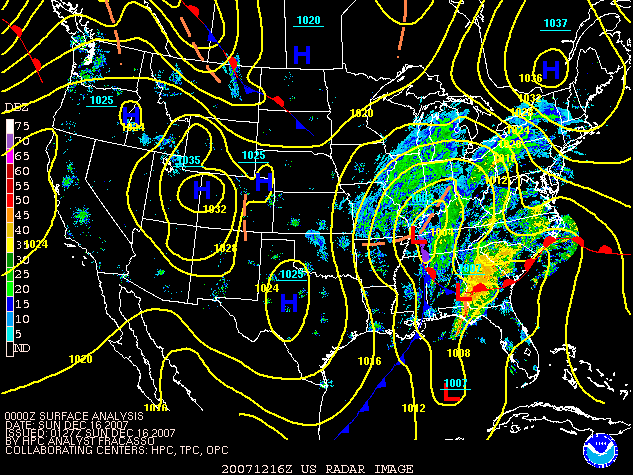
The Mid-December 2007 North American Winter storms was a series of winter storm
s that affected much of central and eastern North America
from December 8 to December 18, 2007. The systems affected areas from Oklahoma
to Newfoundland and Labrador
with freezing rain
, thunderstorm
s, sleet
, snow
, damaging winds, and blizzard-like conditions in various areas. The first two storms produced copious amounts of ice across the Midwestern United States
and Great Plains
from December 8 to December 11, knocking out power to approximately 1.5 million customers from Oklahoma
north to Iowa
. The second storm moved northeast, producing heavy snow across New York
and New England
. A third storm was responsible for a major winter storm from Kansas
to the Canadian Maritimes
, bringing locally record-breaking snowfalls to Ontario
, an icestorm across the Appalachians, and thunderstorms and tornadoes to the Southeastern United States
.
The ice storms were responsible for at least 38 deaths across three states . At least 25 additional deaths were blamed on the December 15–16 Midwest and Eastern snow storm and its aftermath across six US States and three Canadian provinces; 1 additional death was caused by the severe weather outbreak in the Southeast.
. Many areas had received close to three-quarters of an inch of ice from Nebraska
to Illinois
, causing tens of thousands of power outages and at least 16 deaths across nine states and the Canadian
province of Quebec
, the latter receiving a major snow storm.
Following that winter storm, a large dome of cold air penetrated the Midwest following an Alberta Clipper
, which was responsible for major flooding across the Pacific Northwest
and moderate snows from Alberta
to Maryland
. The first wave of low pressure, which developed across the Southwest on December 8, produced light freezing rain throughout much of the Midwest and southern Ontario
on December 9. A second stronger storm developed across the southwest on December 10 and gave significant snows to the higher elevations of Arizona
near Flagstaff
as well as in Colorado
.
The storm then proceeded to produce a significant swath of ice across much of the Central Plains. Both storms in total produced between a half-inch to an inch of ice from Oklahoma to Wisconsin
, while 8 to 24 inches of snow (20–60 cm) fell over the mountains of Utah
, the highest amount being reported in northern Park City
; 6 to 12 inches(15–30 cm) fell over Colorado and New Mexico
while generally less than 6 inches fell on the northern side of the system from Nebraska
to Quebec
, although 10 inches (25 cm) fell in the Saguenay
region of Quebec due to the orographic effect and Lake Saint-Jean. A mixture of snow, sleet, ice, and rain also fell across many of the affected areas. The main energy of the system responsible for the ice storm later moved east and affected portions of the Northeast and Middle Atlantic States with snow and rain on December 13, with the heaviest snow falling across southern and central New York and central New England
. Portions of Massachusetts, Connecticut and New York received as much as 12 inches (30 cm) of snow from the storm, including 7 inches (18 cm) in Boston
.
Another major winter storm developed on December 14 east of the Rockies and across the southern states and traveled across many of the same areas, bringing significant snows to areas that were affected by both ice storms. Portions of Kansas
received over a foot (30 cm) of snow on top of the accumulated ice.. The system moved across the Great Lakes region on December 15 and 16 and intensified while adding moisture from a developing coastal low as well as residual moisture from what was Tropical Storm Olga
that affected most of the Antilles
and Caribbean
. Several areas in the Midwest and eastern North America received close to a foot of snow including Chicago
, some areas of the Toronto
and Detroit areas, Montreal
, and Ottawa
. Accumulations of as much as 20 inches (50 cm) fell across northern New England, northern New York, eastern Ontario from rural eastern Ottawa to Cornwall, and north of the Saint Lawrence River
in the province of Quebec into the Charlevoix
region. Thundersnow was even reported across portions of southern Ontario and Quebec. Widespread amounts of snow between 8 to 14 inches (20–35 cm) were reported across Ontario, Quebec, most of New England and the Canadian Maritimes as well as in several areas of the Midwest including Kansas and Missouri, while between a half-inch to an inch (13–25 mm) of ice fell across higher elevations in Maryland
and Virginia with significant icing as well over West Virginia
and Pennsylvania
. This was accompanied by heavy rain between 2 to 4 inches (50–100 mm) south of the Mason-Dixon Line
towards the Carolinas and the Southeast, with significant rainfall across the Middle Atlantic Coast, coastal sections of Nova Scotia
, and the Avalon Peninsula
of Newfoundland and Labrador. Additionally, heavy thunderstorms developed across the Southern states near the Gulf of Mexico
coast, where tornado watch
es were issued for portions of Alabama
, Florida
, Georgia, and South Carolina
on December 15 with several tornadoes later confirmed. The storm finally exited off the coast into the Atlantic Ocean
on December 18.
The series of storms that affected the Midwest and East are similar to those that took place during January 2007
as several storms traveled across the same areas, killing at least 85 across several states and Canadian provinces. It was also similar to (but much less severe than) the historic Ice Storm of 1998
which blanketed much of eastern Canada from Ontario to New Brunswick
.
, four in Kansas, three in Missouri
and one in Nebraska
; most of the fatalities were from traffic accidents caused by the icy weather, including four people in a single accident on Interstate 40
west of Okemah, Oklahoma
. Two people died from a falling tree branch and from hypothermia.
, 17,000 in Iowa
, 25,000 in Kansas , with scattered power outages also reported in Nebraska
and Illinois
. It was predicted that it could take 7–10 days to restore power to everybody. The city of Jones, Oklahoma
, was left with no electricity to feed high pressure water into the city, while most of its high school was heavily damaged due to a fire. Several other storm-related structural fires occurred, with one smoke-inhalation death from a storm-related fire in Tulsa
. FEMA
and the Army Corps of Engineers shipped generators and bottled water to Oklahoma, where some hospitals were running on backup generators.
Kansas Governor
Kathleen Sebelius
declared a state-wide state of emergency
prior to the storm's arrival while President
George W. Bush
issued a similar state of emergency for the state of Oklahoma before declaring a federal emergency. While the city of Norman
was declared to be a disaster area
by Mayor Cindy Rosenthal. Oklahoma Governor
Brad Henry
cut short a vacation to tour up the hardest hit areas by the storm including northwestern Oklahoma City and later signed a federal disaster declaration. It was reported that damage to utility equipment alone was estimated at over $30 million in seven counties alone including the Oklahoma City
and Tulsa
metropolitan areas. After the initial round of ice on Sunday, Governor Matt Blunt
issued a state of emergency for parts of Missouri.
including Republican
Candidate Mike Huckabee
as his plane was unable to land in western Iowa but did so in Omaha, Nebraska
. An appearance by former President Bill Clinton
on behalf of Hillary Clinton's campaign was also canceled due to the weather. One event scheduled by former North Carolina
Senator
and Democratic
candidate John Edwards
was also canceled.
Chicago O'Hare International Airport canceled at least 560 flights , while Tulsa International Airport
was forced to halt flights on the 10th after losing power for 10 hours while nearly 100 flights were grounded at Kansas City International Airport
. Ice forced schools to close from Oklahoma to upstate New York
.
As the system moved northeast towards New England and New York on December 13, several delays were reported across several airports while 200 flights were canceled at Newark International Airport and 450 at Boston Logan International Airport. Numerous accidents on several Interstate Highways were reported across Connecticut
forcing at times the partial or complete closures of portions of certain highways. In Monroe County, New York, which includes the city of Rochester, the emergency dispatch center received 1,800 calls for collisions but no serious injuries were reported. During the worst of the storm double-trailer rigs and propane tankers were banned from Interstate 90
in western Massachusetts.. There were no weather-related fatalities reported across the Northeast for this storm system.
Schools and government offices from Massachusetts
to New Jersey
and Pennsylvania
were closed early or for all day, and locally some students were stranded for a few hours at various schools particularly in the Boston area where there was criticism over the management of the storm. In Providence, RI, students who had been dismissed early were stranded on school buses for up to eight hours. The storm did not affect professional sporting, as the National Hockey League
game between the New Jersey Devils
and the Boston Bruins
went ahead as scheduled in Boston despite a game attendance of about 1500 at TD Banknorth Garden
.
Heavy snow up to one foot in total hampered recovery efforts across areas that were hit by the ice storm in Kansas as tens of thousands were still without power during the winter storm. In Chicago, more than expected snowfall along with fog and wind caused an additional 200 flight cancellations at O'Hare and Midway Airports. Numerous cancellations were reported in Buffalo
, Toronto (nearly 300 flights in total), Ottawa Macdonald-Cartier International Airport
(over 100 flights), Quebec City
, Montreal (300 total flights), Boston (about 300 additional flights), Portland, Maine
, and other major airports. A U.S. Airways plane carrying 31 passengers slid off a runaway at an airport in Rhode Island
without causing any injuries. At Cleveland-Hopkins International Airport, the NFL's Buffalo Bills airplane got stuck on a runway because of accumulating snow due to a Lake Erie
snowsquall
after their game against the Cleveland Browns so the team was forced to return to Buffalo
by bus.
after the ice melting over the Canadian Arctic and the British Columbia
floods of December 3.
 In Brighton, Massachusetts, the heavy snows and rains caused the roof of a pharmacy to collapse under the heavy weight of the snow but only minor injuries were reported because of falling debris. Severals areas across New York, Michigan and Indiana declared snow emergencies..
Heavy ice across the Poconos and Pennsylvania
was responsible for the collapse of two television towers at Penobscot Mountain in Luzerne County
near Scranton
that knocked out transmission for several nearby television stations. Strong winds in excess of 40 mph (64 km/h) also caused localized damage to roofs, power lines and trees across several states including Pennsylvania, Massachusetts and Rhode Island
. Strong winds in excess of 100 km/h was also reported across much of Eastern Canada, particularly in Cape Breton, the shore of the Gulf of Saint Lawrence
and most of the island of Newfoundland where a peak gust of 181 km/h was reported in the Wreckhouse
region with other gusts measuring over 120 km/h in Bonavista
, Port-aux-Basques and Long Pond. In Matane, Quebec strong winds along the Saint Lawrence River
caused storm surge
waves that crashed ashore and flooded over 10 homes. Over 160,000 customers in Pennsylvania lost power due to ice and sleet, 20 000 in the Canadian Maritimes due to strong winds while scattered power outages were reported in Illinois, Vermont, Ontario and Quebec. In eastern Quebec, 3 000 customers were left without power while roads were mostly inaccessible to maintenance and Hydro-Québec
crews because of near zero visibility and heavy snow accumulations.
 Hundreds of accidents (including two fatal ones) were reported by Ontario Provincial Police
by the Sûreté du Québec
across Ontario, Quebec and across several US States including a pile-up that involved at least seven tractor-trailers on Highway 401
near Cornwall
which temporarily closed the road. A second pile-up on Highway 401 near Kingston
caused a rig to leaked over 300 liters of fuel into a creek. Another pile-up involving a tractor-trailer was reported on Autoroute 40
west of Montreal forcing the shutdown of it as the trailer overturned and spilled kerosene on the roadway. Autoroutes 20
and 440
and Highways 132
, 138
and 175
north and east of Quebec City were shut down due to heavy and blowing snow.
and University of Michigan
where undergraduate students where expected to received their diplomas. The Canadian Broadcasting Corporation
also postponed a fund-raising concert in Summerside, Prince Edward Island
. Several schools across the Northeastern United States, Quebec, Ontario and the Maritimes were closed and mornings sessions at Université Laval
were also suspended.
Games between the New England Patriots
and the New York Jets
in Foxborough, Massachusetts
, the Cleveland Browns
and the Buffalo Bills
in Cleveland
and the Pittsburgh Steelers
and Jacksonville Jaguars
in Pittsburgh
were played in difficult conditions with snow, sleet and strong winds. At Giants Stadium
in East Rutherford, New Jersey
, where the New York Giants
and Washington Redskins
played the Sunday Night match-up
, strong winds collapsed a fabric dome used for hospitality events before and after games but no one was injured on the incident. In the National Basketball Association
game between the Boston Celtics
and the Toronto Raptors
, the game was delayed due to a leak coming the roof of Toronto
's Air Canada Centre
during the peak of the snowstorm while many seats were empty despite an announced sellout for the game.
), one in Wisconsin , seven in Michigan , three in Massachusetts , one in Maine three in Ontario , one in Nova Scotia
and two in Quebec Most fatalities were as a result of motor vehicle accidents, but deaths due to heart-attacks while shoveling and being buried by snow were also reported.
and the Dominican Republic
. 12 tornadoes were reported with an EF2 being the strongest one confirmed in the Lothair, Georgia
area. Another tornado in Georgia was responsible for the death of a truck driver on Interstate 75
when the strong winds overturned his tractor-trailer. Significant damage was reported in several areas from several different tornadoes including one that damaged the Pasco County
Jail
in Florida
.
Winter storm
A winter storm is an event in which the dominant varieties of precipitation are formed that only occur at low temperatures, such as snow or sleet, or a rainstorm where ground temperatures are low enough to allow ice to form...
s that affected much of central and eastern North America
North America
North America is a continent wholly within the Northern Hemisphere and almost wholly within the Western Hemisphere. It is also considered a northern subcontinent of the Americas...
from December 8 to December 18, 2007. The systems affected areas from Oklahoma
Oklahoma
Oklahoma is a state located in the South Central region of the United States of America. With an estimated 3,751,351 residents as of the 2010 census and a land area of 68,667 square miles , Oklahoma is the 28th most populous and 20th-largest state...
to Newfoundland and Labrador
Newfoundland and Labrador
Newfoundland and Labrador is the easternmost province of Canada. Situated in the country's Atlantic region, it incorporates the island of Newfoundland and mainland Labrador with a combined area of . As of April 2011, the province's estimated population is 508,400...
with freezing rain
Freezing rain
Freezing rain is the name given to rain that falls when surface temperatures are below freezing. The raindrops become supercooled while passing through a sub-freezing layer of air, many hundred feet , just above the surface, and then freeze upon impact with any object they encounter. The resulting...
, thunderstorm
Thunderstorm
A thunderstorm, also known as an electrical storm, a lightning storm, thundershower or simply a storm is a form of weather characterized by the presence of lightning and its acoustic effect on the Earth's atmosphere known as thunder. The meteorologically assigned cloud type associated with the...
s, sleet
Ice storm
An ice storm is a type of winter storm characterized by freezing rain, also known as a glaze event or in some parts of the United States as a silver thaw. The U.S. National Weather Service defines an ice storm as a storm which results in the accumulation of at least of ice on exposed surfaces...
, snow
Snow
Snow is a form of precipitation within the Earth's atmosphere in the form of crystalline water ice, consisting of a multitude of snowflakes that fall from clouds. Since snow is composed of small ice particles, it is a granular material. It has an open and therefore soft structure, unless packed by...
, damaging winds, and blizzard-like conditions in various areas. The first two storms produced copious amounts of ice across the Midwestern United States
Midwestern United States
The Midwestern United States is one of the four U.S. geographic regions defined by the United States Census Bureau, providing an official definition of the American Midwest....
and Great Plains
Great Plains
The Great Plains are a broad expanse of flat land, much of it covered in prairie, steppe and grassland, which lies west of the Mississippi River and east of the Rocky Mountains in the United States and Canada. This area covers parts of the U.S...
from December 8 to December 11, knocking out power to approximately 1.5 million customers from Oklahoma
Oklahoma
Oklahoma is a state located in the South Central region of the United States of America. With an estimated 3,751,351 residents as of the 2010 census and a land area of 68,667 square miles , Oklahoma is the 28th most populous and 20th-largest state...
north to Iowa
Iowa
Iowa is a state located in the Midwestern United States, an area often referred to as the "American Heartland". It derives its name from the Ioway people, one of the many American Indian tribes that occupied the state at the time of European exploration. Iowa was a part of the French colony of New...
. The second storm moved northeast, producing heavy snow across New York
New York
New York is a state in the Northeastern region of the United States. It is the nation's third most populous state. New York is bordered by New Jersey and Pennsylvania to the south, and by Connecticut, Massachusetts and Vermont to the east...
and New England
New England
New England is a region in the northeastern corner of the United States consisting of the six states of Maine, New Hampshire, Vermont, Massachusetts, Rhode Island, and Connecticut...
. A third storm was responsible for a major winter storm from Kansas
Kansas
Kansas is a US state located in the Midwestern United States. It is named after the Kansas River which flows through it, which in turn was named after the Kansa Native American tribe, which inhabited the area. The tribe's name is often said to mean "people of the wind" or "people of the south...
to the Canadian Maritimes
Maritimes
The Maritime provinces, also called the Maritimes or the Canadian Maritimes, is a region of Eastern Canada consisting of three provinces, New Brunswick, Nova Scotia, and Prince Edward Island. On the Atlantic coast, the Maritimes are a subregion of Atlantic Canada, which also includes the...
, bringing locally record-breaking snowfalls to Ontario
Ontario
Ontario is a province of Canada, located in east-central Canada. It is Canada's most populous province and second largest in total area. It is home to the nation's most populous city, Toronto, and the nation's capital, Ottawa....
, an icestorm across the Appalachians, and thunderstorms and tornadoes to the Southeastern United States
Southeastern United States
The Southeastern United States, colloquially referred to as the Southeast, is the eastern portion of the Southern United States. It is one of the most populous regions in the United States of America....
.
The ice storms were responsible for at least 38 deaths across three states . At least 25 additional deaths were blamed on the December 15–16 Midwest and Eastern snow storm and its aftermath across six US States and three Canadian provinces; 1 additional death was caused by the severe weather outbreak in the Southeast.
Meteorological synopsis
Much of the affected areas were already hit by a significant winter storm during the weekend of December 1 and December 2Early December 2007 North American winter storm
The Early December 2007 North American winter storm was a major winter storm which affected the majority of the United States and portions of southern Canada from November 29 to December 5, hitting the Intermountain West and Midwestern United States, the Great Lakes region and the Northeast...
. Many areas had received close to three-quarters of an inch of ice from Nebraska
Nebraska
Nebraska is a state on the Great Plains of the Midwestern United States. The state's capital is Lincoln and its largest city is Omaha, on the Missouri River....
to Illinois
Illinois
Illinois is the fifth-most populous state of the United States of America, and is often noted for being a microcosm of the entire country. With Chicago in the northeast, small industrial cities and great agricultural productivity in central and northern Illinois, and natural resources like coal,...
, causing tens of thousands of power outages and at least 16 deaths across nine states and the Canadian
Canada
Canada is a North American country consisting of ten provinces and three territories. Located in the northern part of the continent, it extends from the Atlantic Ocean in the east to the Pacific Ocean in the west, and northward into the Arctic Ocean...
province of Quebec
Quebec
Quebec or is a province in east-central Canada. It is the only Canadian province with a predominantly French-speaking population and the only one whose sole official language is French at the provincial level....
, the latter receiving a major snow storm.
Following that winter storm, a large dome of cold air penetrated the Midwest following an Alberta Clipper
Alberta clipper
An Alberta clipper is a fast moving low pressure area which generally affects the central provinces of Canada and parts of the Upper Midwest and Great Lakes regions of the United States. Most clippers occur between December and February, but can also occur occasionally in the month of November...
, which was responsible for major flooding across the Pacific Northwest
Pacific Northwest
The Pacific Northwest is a region in northwestern North America, bounded by the Pacific Ocean to the west and, loosely, by the Rocky Mountains on the east. Definitions of the region vary and there is no commonly agreed upon boundary, even among Pacific Northwesterners. A common concept of the...
and moderate snows from Alberta
Alberta
Alberta is a province of Canada. It had an estimated population of 3.7 million in 2010 making it the most populous of Canada's three prairie provinces...
to Maryland
Maryland
Maryland is a U.S. state located in the Mid Atlantic region of the United States, bordering Virginia, West Virginia, and the District of Columbia to its south and west; Pennsylvania to its north; and Delaware to its east...
. The first wave of low pressure, which developed across the Southwest on December 8, produced light freezing rain throughout much of the Midwest and southern Ontario
Ontario
Ontario is a province of Canada, located in east-central Canada. It is Canada's most populous province and second largest in total area. It is home to the nation's most populous city, Toronto, and the nation's capital, Ottawa....
on December 9. A second stronger storm developed across the southwest on December 10 and gave significant snows to the higher elevations of Arizona
Arizona
Arizona ; is a state located in the southwestern region of the United States. It is also part of the western United States and the mountain west. The capital and largest city is Phoenix...
near Flagstaff
Flagstaff, Arizona
Flagstaff is a city located in northern Arizona, in the southwestern United States. In 2010, the city's population was 65,870. The population of the Metropolitan Statistical Area was at 134,421 in 2010. It is the county seat of Coconino County...
as well as in Colorado
Colorado
Colorado is a U.S. state that encompasses much of the Rocky Mountains as well as the northeastern portion of the Colorado Plateau and the western edge of the Great Plains...
.
| Total | Location |
|---|---|
| 1.50 in (3.8 cm) | Pittsburg, Kansas Pittsburg, Kansas Pittsburg is a city in Crawford County, in southeastern Kansas, United States. It is the most populous city in Crawford County and in southeastern Kansas. As of the 2010 census, the city population was 20,233.-History:... |
| 1.50 in (3.8 cm) | Joplin, Missouri Joplin, Missouri Joplin is a city in southern Jasper County and northern Newton County in the southwestern corner of the US state of Missouri. Joplin is the largest city in Jasper County, though it is not the county seat. As of the 2010 census, the city population was 50,150... |
| 1.25 in (3.2 cm) | Vinita, Oklahoma Vinita, Oklahoma Vinita is a city in south-central Craig County, Oklahoma. As of 2009, the population estimate was 6,057. It is the county seat of Craig County.-Geography:... |
| 1.00 in (2.5 cm) | Ottumwa, Iowa Ottumwa, Iowa Ottumwa is a city in and the county seat of Wapello County, Iowa, United States. The population was 24,998 at the 2000 census. It is located in the southeastern part of Iowa, and the city is split into northern and southern halves by the Des Moines River.... |
| 0.75 in (1.9 cm) | Danbury, Nebraska Danbury, Nebraska Danbury is a village in Red Willow County, Nebraska, United States. The population was 127 at the 2000 census.-Geography:Danbury is located at .... |
| 0.50 in (1.3 cm) | Spearman, Texas Spearman, Texas Spearman is a city in Hansford County, Texas, in the United States. As of the 2010 census, the city population was 3,368. It is the county seat of Hansford County, and is known for its collection of windmills from the J.B. Buchanan windmill collection. The city was named for Thomas E... |
| 0.50 in (1.3 cm) | Rensselaer, Indiana Rensselaer, Indiana -Demographics:As of the census of 2000, there were 5,294 people, 2,158 households, and 1,404 families residing in the city. The population density was 1,824.8 people per square mile . There were 2,296 housing units at an average density of 791.4 per square mile... |
| 0.30 in (0.8 cm) | Niskayuna, New York |
| 0.25 in (0.6 cm) | Sparta, Illinois Sparta, Illinois Sparta is a city in Randolph County, Illinois, United States. The population was 4,486 at the 2000 census.The city was the principal filming location for the 1967 film In the Heat of the Night.-Geography:Sparta is located at .... |
| 0.25 in (0.6 cm) | Montpelier, Ohio Montpelier, Ohio Montpelier is a village in Williams County, Ohio, United States. The population was 4,320 at the 2000 census.-Geography:Montpelier is located at .... |
| All totals are freezing rain only | |
The storm then proceeded to produce a significant swath of ice across much of the Central Plains. Both storms in total produced between a half-inch to an inch of ice from Oklahoma to Wisconsin
Wisconsin
Wisconsin is a U.S. state located in the north-central United States and is part of the Midwest. It is bordered by Minnesota to the west, Iowa to the southwest, Illinois to the south, Lake Michigan to the east, Michigan to the northeast, and Lake Superior to the north. Wisconsin's capital is...
, while 8 to 24 inches of snow (20–60 cm) fell over the mountains of Utah
Utah
Utah is a state in the Western United States. It was the 45th state to join the Union, on January 4, 1896. Approximately 80% of Utah's 2,763,885 people live along the Wasatch Front, centering on Salt Lake City. This leaves vast expanses of the state nearly uninhabited, making the population the...
, the highest amount being reported in northern Park City
Park City, Utah
Park City is a town in Summit and Wasatch counties in the U.S. state of Utah. It is considered to be part of the Wasatch Back. The city is southeast of downtown Salt Lake City and from Salt Lake City's east edge of Sugar House along Interstate 80. The population was 7,558 at the 2010 census...
; 6 to 12 inches(15–30 cm) fell over Colorado and New Mexico
New Mexico
New Mexico is a state located in the southwest and western regions of the United States. New Mexico is also usually considered one of the Mountain States. With a population density of 16 per square mile, New Mexico is the sixth-most sparsely inhabited U.S...
while generally less than 6 inches fell on the northern side of the system from Nebraska
Nebraska
Nebraska is a state on the Great Plains of the Midwestern United States. The state's capital is Lincoln and its largest city is Omaha, on the Missouri River....
to Quebec
Quebec
Quebec or is a province in east-central Canada. It is the only Canadian province with a predominantly French-speaking population and the only one whose sole official language is French at the provincial level....
, although 10 inches (25 cm) fell in the Saguenay
Saguenay-Lac-Saint-Jean
Saguenay–Lac-Saint-Jean is a region in Quebec, Canada. It contains the Saguenay Fjord, the estuary of the Saguenay River, stretching through much of the region...
region of Quebec due to the orographic effect and Lake Saint-Jean. A mixture of snow, sleet, ice, and rain also fell across many of the affected areas. The main energy of the system responsible for the ice storm later moved east and affected portions of the Northeast and Middle Atlantic States with snow and rain on December 13, with the heaviest snow falling across southern and central New York and central New England
New England
New England is a region in the northeastern corner of the United States consisting of the six states of Maine, New Hampshire, Vermont, Massachusetts, Rhode Island, and Connecticut...
. Portions of Massachusetts, Connecticut and New York received as much as 12 inches (30 cm) of snow from the storm, including 7 inches (18 cm) in Boston
Boston
Boston is the capital of and largest city in Massachusetts, and is one of the oldest cities in the United States. The largest city in New England, Boston is regarded as the unofficial "Capital of New England" for its economic and cultural impact on the entire New England region. The city proper had...
.
Another major winter storm developed on December 14 east of the Rockies and across the southern states and traveled across many of the same areas, bringing significant snows to areas that were affected by both ice storms. Portions of Kansas
Kansas
Kansas is a US state located in the Midwestern United States. It is named after the Kansas River which flows through it, which in turn was named after the Kansa Native American tribe, which inhabited the area. The tribe's name is often said to mean "people of the wind" or "people of the south...
received over a foot (30 cm) of snow on top of the accumulated ice.. The system moved across the Great Lakes region on December 15 and 16 and intensified while adding moisture from a developing coastal low as well as residual moisture from what was Tropical Storm Olga
Tropical Storm Olga (2007)
Tropical Storm Olga was the fifteenth named storm of the 2007 Atlantic hurricane season. In the second week of December, after the official end of the hurricane season, a low developed east of the northernmost Lesser Antilles. It slowly acquired tropical characteristics, and late on December 10,...
that affected most of the Antilles
Antilles
The Antilles islands form the greater part of the West Indies in the Caribbean Sea. The Antilles are divided into two major groups: the "Greater Antilles" to the north and west, including the larger islands of Cuba, Jamaica, Hispaniola , and Puerto Rico; and the smaller "Lesser Antilles" on the...
and Caribbean
Caribbean
The Caribbean is a crescent-shaped group of islands more than 2,000 miles long separating the Gulf of Mexico and the Caribbean Sea, to the west and south, from the Atlantic Ocean, to the east and north...
. Several areas in the Midwest and eastern North America received close to a foot of snow including Chicago
Chicago
Chicago is the largest city in the US state of Illinois. With nearly 2.7 million residents, it is the most populous city in the Midwestern United States and the third most populous in the US, after New York City and Los Angeles...
, some areas of the Toronto
Toronto
Toronto is the provincial capital of Ontario and the largest city in Canada. It is located in Southern Ontario on the northwestern shore of Lake Ontario. A relatively modern city, Toronto's history dates back to the late-18th century, when its land was first purchased by the British monarchy from...
and Detroit areas, Montreal
Montreal
Montreal is a city in Canada. It is the largest city in the province of Quebec, the second-largest city in Canada and the seventh largest in North America...
, and Ottawa
Ottawa
Ottawa is the capital of Canada, the second largest city in the Province of Ontario, and the fourth largest city in the country. The city is located on the south bank of the Ottawa River in the eastern portion of Southern Ontario...
. Accumulations of as much as 20 inches (50 cm) fell across northern New England, northern New York, eastern Ontario from rural eastern Ottawa to Cornwall, and north of the Saint Lawrence River
Saint Lawrence River
The Saint Lawrence is a large river flowing approximately from southwest to northeast in the middle latitudes of North America, connecting the Great Lakes with the Atlantic Ocean. It is the primary drainage conveyor of the Great Lakes Basin...
in the province of Quebec into the Charlevoix
Charlevoix
The Charlevoix region, located in Quebec, includes parts of the north shore of the Saint Lawrence River and the Laurentian Mountains region of the Canadian Shield...
region. Thundersnow was even reported across portions of southern Ontario and Quebec. Widespread amounts of snow between 8 to 14 inches (20–35 cm) were reported across Ontario, Quebec, most of New England and the Canadian Maritimes as well as in several areas of the Midwest including Kansas and Missouri, while between a half-inch to an inch (13–25 mm) of ice fell across higher elevations in Maryland
Maryland
Maryland is a U.S. state located in the Mid Atlantic region of the United States, bordering Virginia, West Virginia, and the District of Columbia to its south and west; Pennsylvania to its north; and Delaware to its east...
and Virginia with significant icing as well over West Virginia
West Virginia
West Virginia is a state in the Appalachian and Southeastern regions of the United States, bordered by Virginia to the southeast, Kentucky to the southwest, Ohio to the northwest, Pennsylvania to the northeast and Maryland to the east...
and Pennsylvania
Pennsylvania
The Commonwealth of Pennsylvania is a U.S. state that is located in the Northeastern and Mid-Atlantic regions of the United States. The state borders Delaware and Maryland to the south, West Virginia to the southwest, Ohio to the west, New York and Ontario, Canada, to the north, and New Jersey to...
. This was accompanied by heavy rain between 2 to 4 inches (50–100 mm) south of the Mason-Dixon Line
Mason-Dixon line
The Mason–Dixon Line was surveyed between 1763 and 1767 by Charles Mason and Jeremiah Dixon in the resolution of a border dispute between British colonies in Colonial America. It forms a demarcation line among four U.S. states, forming part of the borders of Pennsylvania, Maryland, Delaware, and...
towards the Carolinas and the Southeast, with significant rainfall across the Middle Atlantic Coast, coastal sections of Nova Scotia
Nova Scotia
Nova Scotia is one of Canada's three Maritime provinces and is the most populous province in Atlantic Canada. The name of the province is Latin for "New Scotland," but "Nova Scotia" is the recognized, English-language name of the province. The provincial capital is Halifax. Nova Scotia is the...
, and the Avalon Peninsula
Avalon Peninsula
The Avalon Peninsula is a large peninsula that makes up the southeast portion of the island of Newfoundland.The peninsula is home to 257,223 people, which is approximately 51% of Newfoundland's population in 2009, and is the location of the provincial capital, St. John's. It is connected to the...
of Newfoundland and Labrador. Additionally, heavy thunderstorms developed across the Southern states near the Gulf of Mexico
Gulf of Mexico
The Gulf of Mexico is a partially landlocked ocean basin largely surrounded by the North American continent and the island of Cuba. It is bounded on the northeast, north and northwest by the Gulf Coast of the United States, on the southwest and south by Mexico, and on the southeast by Cuba. In...
coast, where tornado watch
Tornado watch
A tornado watch is issued when conditions are right for a tornado to form. Since any thunderstorm capable of producing a tornado is defined as severe, a tornado watch is also automatically a severe thunderstorm watch...
es were issued for portions of Alabama
Alabama
Alabama is a state located in the southeastern region of the United States. It is bordered by Tennessee to the north, Georgia to the east, Florida and the Gulf of Mexico to the south, and Mississippi to the west. Alabama ranks 30th in total land area and ranks second in the size of its inland...
, Florida
Florida
Florida is a state in the southeastern United States, located on the nation's Atlantic and Gulf coasts. It is bordered to the west by the Gulf of Mexico, to the north by Alabama and Georgia and to the east by the Atlantic Ocean. With a population of 18,801,310 as measured by the 2010 census, it...
, Georgia, and South Carolina
South Carolina
South Carolina is a state in the Deep South of the United States that borders Georgia to the south, North Carolina to the north, and the Atlantic Ocean to the east. Originally part of the Province of Carolina, the Province of South Carolina was one of the 13 colonies that declared independence...
on December 15 with several tornadoes later confirmed. The storm finally exited off the coast into the Atlantic Ocean
Atlantic Ocean
The Atlantic Ocean is the second-largest of the world's oceanic divisions. With a total area of about , it covers approximately 20% of the Earth's surface and about 26% of its water surface area...
on December 18.
The series of storms that affected the Midwest and East are similar to those that took place during January 2007
January 2007 North American ice storm
The North American ice storm of 2007 was a severe ice storm that impacted a large swath of North America from the Rio Grande Valley to New England and southeastern Canada starting on January 11, 2007 through January 16, followed by a second wave in the Southern United States from Texas to the...
as several storms traveled across the same areas, killing at least 85 across several states and Canadian provinces. It was also similar to (but much less severe than) the historic Ice Storm of 1998
North American ice storm of 1998
The North American ice storm of 1998 was a massive combination of five smaller successive ice storms which combined to strike a relatively narrow swath of land from eastern Ontario to southern Quebec to Nova Scotia in Canada, and bordering areas from northern New York to central Maine in the...
which blanketed much of eastern Canada from Ontario to New Brunswick
New Brunswick
New Brunswick is one of Canada's three Maritime provinces and is the only province in the federation that is constitutionally bilingual . The provincial capital is Fredericton and Saint John is the most populous city. Greater Moncton is the largest Census Metropolitan Area...
.
Fatalities
At least 38 people were killed by the storm including 27 in OklahomaOklahoma
Oklahoma is a state located in the South Central region of the United States of America. With an estimated 3,751,351 residents as of the 2010 census and a land area of 68,667 square miles , Oklahoma is the 28th most populous and 20th-largest state...
, four in Kansas, three in Missouri
Missouri
Missouri is a US state located in the Midwestern United States, bordered by Iowa, Illinois, Kentucky, Tennessee, Arkansas, Oklahoma, Kansas and Nebraska. With a 2010 population of 5,988,927, Missouri is the 18th most populous state in the nation and the fifth most populous in the Midwest. It...
and one in Nebraska
Nebraska
Nebraska is a state on the Great Plains of the Midwestern United States. The state's capital is Lincoln and its largest city is Omaha, on the Missouri River....
; most of the fatalities were from traffic accidents caused by the icy weather, including four people in a single accident on Interstate 40
Interstate 40
Interstate 40 is the third-longest major east–west Interstate Highway in the United States, after I-90 and I-80. Its western end is at Interstate 15 in Barstow, California; its eastern end is at a concurrency of U.S. Route 117 and North Carolina Highway 132 in Wilmington, North Carolina...
west of Okemah, Oklahoma
Okemah, Oklahoma
Okemah is a city in Okfuskee County, Oklahoma, United States. It is the county seat of Okfuskee County. It is the birthplace of folk music legend Woody Guthrie. Thlopthlocco Tribal Town, a federally recognized Muscogee Indian tribe, is headquartered in Okemah...
. Two people died from a falling tree branch and from hypothermia.
Power outages
Overall, nearly 1.5 million customers have lost power in total. The storm caused the largest power outage in Oklahoma history, where more than 600,000 homes and businesses, accounting for approximately 40% of the population, lost power during the peak of the storm; 350,000 customers were without power in other states , including 100,000 in MissouriMissouri
Missouri is a US state located in the Midwestern United States, bordered by Iowa, Illinois, Kentucky, Tennessee, Arkansas, Oklahoma, Kansas and Nebraska. With a 2010 population of 5,988,927, Missouri is the 18th most populous state in the nation and the fifth most populous in the Midwest. It...
, 17,000 in Iowa
Iowa
Iowa is a state located in the Midwestern United States, an area often referred to as the "American Heartland". It derives its name from the Ioway people, one of the many American Indian tribes that occupied the state at the time of European exploration. Iowa was a part of the French colony of New...
, 25,000 in Kansas , with scattered power outages also reported in Nebraska
Nebraska
Nebraska is a state on the Great Plains of the Midwestern United States. The state's capital is Lincoln and its largest city is Omaha, on the Missouri River....
and Illinois
Illinois
Illinois is the fifth-most populous state of the United States of America, and is often noted for being a microcosm of the entire country. With Chicago in the northeast, small industrial cities and great agricultural productivity in central and northern Illinois, and natural resources like coal,...
. It was predicted that it could take 7–10 days to restore power to everybody. The city of Jones, Oklahoma
Jones, Oklahoma
Jones is a town in Oklahoma County, Oklahoma, United States, and a part of the Oklahoma City Metropolitan Area. The population was 2,517 at the 2000 census.-Early History:...
, was left with no electricity to feed high pressure water into the city, while most of its high school was heavily damaged due to a fire. Several other storm-related structural fires occurred, with one smoke-inhalation death from a storm-related fire in Tulsa
Tulsa, Oklahoma
Tulsa is the second-largest city in the state of Oklahoma and 46th-largest city in the United States. With a population of 391,906 as of the 2010 census, it is the principal municipality of the Tulsa Metropolitan Area, a region with 937,478 residents in the MSA and 988,454 in the CSA. Tulsa's...
. FEMA
Federal Emergency Management Agency
The Federal Emergency Management Agency is an agency of the United States Department of Homeland Security, initially created by Presidential Reorganization Plan No. 1 of 1978 and implemented by two Executive Orders...
and the Army Corps of Engineers shipped generators and bottled water to Oklahoma, where some hospitals were running on backup generators.
State of emergencies
| City | Snowfall Amounts |
|---|---|
| Northern Park City, UT Park City, Utah Park City is a town in Summit and Wasatch counties in the U.S. state of Utah. It is considered to be part of the Wasatch Back. The city is southeast of downtown Salt Lake City and from Salt Lake City's east edge of Sugar House along Interstate 80. The population was 7,558 at the 2010 census... |
24 in (61 cm) |
| Pagosa Springs, CO Pagosa Springs, Colorado Pagosa Springs is a Home Rule Municipality that is the county seat of, and the only incorporated municipality in, Archuleta County, Colorado, United States. The population was 1,591 at the 2000 census... |
11 in (27 cm) |
| Los Alamos, NM Los Alamos, New Mexico Los Alamos is a townsite and census-designated place in Los Alamos County, New Mexico, United States, built upon four mesas of the Pajarito Plateau and the adjoining White Rock Canyon. The population of the CDP was 12,019 at the 2010 Census. The townsite or "the hill" is one part of town while... |
7-11 in (17–27 cm) |
| Washburn, ME Washburn, Maine Washburn is a town in Aroostook County, Maine, United States. It was incorporated on February 25, 1861, and named after Israel Washburn, the governor of Maine at the time... |
10 in (25 cm) |
| Saguenay, QC Saguenay, Quebec Saguenay is a city in the Saguenay-Lac-Saint-Jean region of Quebec, Canada, on the Saguenay River, about north of Quebec City.... |
10 in (25 cm) |
| Boulder, CO Boulder, Colorado Boulder is the county seat and most populous city of Boulder County and the 11th most populous city in the U.S. state of Colorado. Boulder is located at the base of the foothills of the Rocky Mountains at an elevation of... |
6-8 in (10–20 cm) |
| Cozad, NE Cozad, Nebraska Cozad is a city in Dawson County, Nebraska, United States. The population was 3,977 at the 2010 census. The town is on the Great Plains of central Nebraska, along the Union Pacific Railroad and U.S. Highway 30, just north of the Platte River... |
6 in (15 cm) |
| Ottawa, ON | 5 in (12 cm) |
| All amounts are snowfall only | |
Kansas Governor
Governor
A governor is a governing official, usually the executive of a non-sovereign level of government, ranking under the head of state...
Kathleen Sebelius
Kathleen Sebelius
Kathleen Sebelius is an American politician currently serving as the 21st Secretary of Health and Human Services. She was the second female Governor of Kansas from 2003 to 2009, the Democratic respondent to the 2008 State of the Union address, and chair-emerita of the Democratic Governors...
declared a state-wide state of emergency
State of emergency
A state of emergency is a governmental declaration that may suspend some normal functions of the executive, legislative and judicial powers, alert citizens to change their normal behaviours, or order government agencies to implement emergency preparedness plans. It can also be used as a rationale...
prior to the storm's arrival while President
President of the United States
The President of the United States of America is the head of state and head of government of the United States. The president leads the executive branch of the federal government and is the commander-in-chief of the United States Armed Forces....
George W. Bush
George W. Bush
George Walker Bush is an American politician who served as the 43rd President of the United States, from 2001 to 2009. Before that, he was the 46th Governor of Texas, having served from 1995 to 2000....
issued a similar state of emergency for the state of Oklahoma before declaring a federal emergency. While the city of Norman
Norman, Oklahoma
Norman is a city in Cleveland County, Oklahoma, United States, and is located south of downtown Oklahoma City. It is part of the Oklahoma City metropolitan area. As of the 2010 census, Norman was to have 110,925 full-time residents, making it the third-largest city in Oklahoma and the...
was declared to be a disaster area
Disaster area
A disaster area is a region or a locale heavily damaged by either natural hazards, such as tornadoes, hurricanes, tsunamis, floods, earthquakes, technological hazards including nuclear and radiation accidents, or sociological hazards like riots, terrorism or war. The population living there often...
by Mayor Cindy Rosenthal. Oklahoma Governor
Governor of Oklahoma
The governor of the state of Oklahoma is the head of state for the state of Oklahoma, United States. Under the Oklahoma Constitution, the governor is also the head of government, serving as the chief executive of the Oklahoma executive branch, of the government of Oklahoma...
Brad Henry
Brad Henry
Charles Bradford "Brad" Henry was the 26th Governor of the U.S. state of Oklahoma. A member of the Democratic Party, he was elected governor in 2002...
cut short a vacation to tour up the hardest hit areas by the storm including northwestern Oklahoma City and later signed a federal disaster declaration. It was reported that damage to utility equipment alone was estimated at over $30 million in seven counties alone including the Oklahoma City
Oklahoma city
Oklahoma City is the capital and largest city of the U.S. state of Oklahoma.Oklahoma City may also refer to:*Oklahoma City metropolitan area*Downtown Oklahoma City*Uptown Oklahoma City*Oklahoma City bombing*Oklahoma City National Memorial...
and Tulsa
Tulsa, Oklahoma
Tulsa is the second-largest city in the state of Oklahoma and 46th-largest city in the United States. With a population of 391,906 as of the 2010 census, it is the principal municipality of the Tulsa Metropolitan Area, a region with 937,478 residents in the MSA and 988,454 in the CSA. Tulsa's...
metropolitan areas. After the initial round of ice on Sunday, Governor Matt Blunt
Matt Blunt
Matthew Roy Blunt served as the 54th Governor of Missouri from 2005 to 2009. Before his election as governor, Blunt served ten years in the United States Navy, was elected to serve in the Missouri General Assembly in 1998 and as Missouri's Secretary of State in 2000.A Republican, Blunt was elected...
issued a state of emergency for parts of Missouri.
Cancellations
The storm, as did the previous storm, disrupted events scheduled by presidential hopefuls for the 2008 US Presidential electionUnited States presidential election, 2008
The United States presidential election of 2008 was the 56th quadrennial presidential election. It was held on November 4, 2008. Democrat Barack Obama, then the junior United States Senator from Illinois, defeated Republican John McCain, the senior U.S. Senator from Arizona. Obama received 365...
including Republican
Republican Party (United States)
The Republican Party is one of the two major contemporary political parties in the United States, along with the Democratic Party. Founded by anti-slavery expansion activists in 1854, it is often called the GOP . The party's platform generally reflects American conservatism in the U.S...
Candidate Mike Huckabee
Mike Huckabee
Michael "Mike" Dale Huckabee is an American politician who served as the 44th Governor of Arkansas from 1996 to 2007. He was a candidate in the 2008 United States Republican presidential primaries, finishing second in delegate count and third in both popular vote and number of states won . He won...
as his plane was unable to land in western Iowa but did so in Omaha, Nebraska
Omaha, Nebraska
Omaha is the largest city in the state of Nebraska, United States, and is the county seat of Douglas County. It is located in the Midwestern United States on the Missouri River, about 20 miles north of the mouth of the Platte River...
. An appearance by former President Bill Clinton
Bill Clinton
William Jefferson "Bill" Clinton is an American politician who served as the 42nd President of the United States from 1993 to 2001. Inaugurated at age 46, he was the third-youngest president. He took office at the end of the Cold War, and was the first president of the baby boomer generation...
on behalf of Hillary Clinton's campaign was also canceled due to the weather. One event scheduled by former North Carolina
North Carolina
North Carolina is a state located in the southeastern United States. The state borders South Carolina and Georgia to the south, Tennessee to the west and Virginia to the north. North Carolina contains 100 counties. Its capital is Raleigh, and its largest city is Charlotte...
Senator
United States Senate
The United States Senate is the upper house of the bicameral legislature of the United States, and together with the United States House of Representatives comprises the United States Congress. The composition and powers of the Senate are established in Article One of the U.S. Constitution. Each...
and Democratic
Democratic Party (United States)
The Democratic Party is one of two major contemporary political parties in the United States, along with the Republican Party. The party's socially liberal and progressive platform is largely considered center-left in the U.S. political spectrum. The party has the lengthiest record of continuous...
candidate John Edwards
John Edwards
Johnny Reid "John" Edwards is an American politician, who served as a U.S. Senator from North Carolina. He was the Democratic nominee for Vice President in 2004, and was a candidate for the Democratic presidential nomination in 2004 and 2008.He defeated incumbent Republican Lauch Faircloth in...
was also canceled.
Chicago O'Hare International Airport canceled at least 560 flights , while Tulsa International Airport
Tulsa International Airport
Tulsa International Airport is a city-owned public-use airport located five miles northeast of downtown Tulsa, a city in Tulsa County, Oklahoma, United States. It was originally named Tulsa Municipal Airport, when the city acquired it in 1929...
was forced to halt flights on the 10th after losing power for 10 hours while nearly 100 flights were grounded at Kansas City International Airport
Kansas City International Airport
Kansas City International Airport , originally named Mid-Continent International Airport, is a public airport located 15 miles northwest of the central business district of Kansas City, in Platte County, Missouri, United States. In 2008, 10,469,892 passengers used the airport...
. Ice forced schools to close from Oklahoma to upstate New York
New York
New York is a state in the Northeastern region of the United States. It is the nation's third most populous state. New York is bordered by New Jersey and Pennsylvania to the south, and by Connecticut, Massachusetts and Vermont to the east...
.
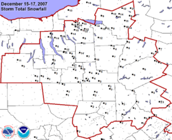
Northeastern United States December 13 storm
| City | Snowfall Amounts |
|---|---|
| Bloomingburg, NY Bloomingburg, New York Bloomingburg, previously Bloomingburgh, is a village in Sullivan County, New York, United States. The population was 353 at the 2000 census.The Village of Bloomingburg is in the Town of Mamakating.- History :... |
10.9 in (26 cm) |
| Boston, MA | 10.5 in (26 cm) |
| Penn Yan, NY Penn Yan, New York Penn Yan is a village in Yates County, New York, USA. The population was 5,219 at the 2000 census. It is the county seat of Yates County and lies at the north end of the east branch of Keuka Lake, one of the Finger Lakes.... |
10 in (25 cm) |
| Binghamton, NY Binghamton, New York Binghamton is a city in the Southern Tier of New York in the United States. It is near the Pennsylvania border, in a bowl-shaped valley at the confluence of the Susquehanna and Chenango Rivers... |
9.5 in (24 cm) |
| Waterbury, CT Waterbury, Connecticut Waterbury is a city in New Haven County, Connecticut, on the Naugatuck River, 33 miles southwest of Hartford and 77 miles northeast of New York City... |
8.4 in (21 cm) |
| Montrose, PA Montrose, Pennsylvania Montrose is a borough in Susquehanna County, Pennsylvania, United States, north by west of Scranton, Pennsylvania. Montrose was laid out in 1812 and incorporated as a borough on March 19, 1824. Its name is a combination of "mont", the French word for “mountain” and Rose, for Dr. L R. Rose, a... |
8.3 cm (21 cm) |
| Emporium, PA Emporium, Pennsylvania Emporium is a borough in Cameron County, Pennsylvania, west-northwest of Williamsport. Early in the twentieth century, it had large powder plants and manufactories of radio tubes, incandescent lamps, paving brick, flour, iron, lumber, sole leather, etc. In 1900, 2,463 people lived in Emporium, and... |
8 in (20 cm) |
| Goshen, NY Goshen (village), New York Goshen is a village in and the county seat of Orange County, New York, United States. The population was 5,676 at the 2000 census. It is part of the Poughkeepsie–Newburgh–Middletown, NY Metropolitan Statistical Area as well as the larger New York–Newark–Bridgeport,... |
7.3 in (19 cm) |
| All amounts are snowfall only | |
As the system moved northeast towards New England and New York on December 13, several delays were reported across several airports while 200 flights were canceled at Newark International Airport and 450 at Boston Logan International Airport. Numerous accidents on several Interstate Highways were reported across Connecticut
Connecticut
Connecticut is a state in the New England region of the northeastern United States. It is bordered by Rhode Island to the east, Massachusetts to the north, and the state of New York to the west and the south .Connecticut is named for the Connecticut River, the major U.S. river that approximately...
forcing at times the partial or complete closures of portions of certain highways. In Monroe County, New York, which includes the city of Rochester, the emergency dispatch center received 1,800 calls for collisions but no serious injuries were reported. During the worst of the storm double-trailer rigs and propane tankers were banned from Interstate 90
Interstate 90
Interstate 90 is the longest Interstate Highway in the United States at . It is the northernmost coast-to-coast interstate, and parallels US 20 for the most part. Its western terminus is in Seattle, at Edgar Martinez Drive S. near Safeco Field and CenturyLink Field, and its eastern terminus is in...
in western Massachusetts.. There were no weather-related fatalities reported across the Northeast for this storm system.
Schools and government offices from Massachusetts
Massachusetts
The Commonwealth of Massachusetts is a state in the New England region of the northeastern United States of America. It is bordered by Rhode Island and Connecticut to the south, New York to the west, and Vermont and New Hampshire to the north; at its east lies the Atlantic Ocean. As of the 2010...
to New Jersey
New Jersey
New Jersey is a state in the Northeastern and Middle Atlantic regions of the United States. , its population was 8,791,894. It is bordered on the north and east by the state of New York, on the southeast and south by the Atlantic Ocean, on the west by Pennsylvania and on the southwest by Delaware...
and Pennsylvania
Pennsylvania
The Commonwealth of Pennsylvania is a U.S. state that is located in the Northeastern and Mid-Atlantic regions of the United States. The state borders Delaware and Maryland to the south, West Virginia to the southwest, Ohio to the west, New York and Ontario, Canada, to the north, and New Jersey to...
were closed early or for all day, and locally some students were stranded for a few hours at various schools particularly in the Boston area where there was criticism over the management of the storm. In Providence, RI, students who had been dismissed early were stranded on school buses for up to eight hours. The storm did not affect professional sporting, as the National Hockey League
National Hockey League
The National Hockey League is an unincorporated not-for-profit association which operates a major professional ice hockey league of 30 franchised member clubs, of which 7 are currently located in Canada and 23 in the United States...
game between the New Jersey Devils
New Jersey Devils
The New Jersey Devils are a professional ice hockey team based in Newark, New Jersey, United States. They are members of the Atlantic Division of the Eastern Conference of the National Hockey League...
and the Boston Bruins
Boston Bruins
The Boston Bruins are a professional ice hockey team based in Boston, Massachusetts, USA. They are members of the Northeast Division of the Eastern Conference of the National Hockey League . The team has been in existence since 1924, and is the league's third-oldest team and its oldest in the...
went ahead as scheduled in Boston despite a game attendance of about 1500 at TD Banknorth Garden
TD Banknorth Garden
TD Garden is a multi-purpose arena in Boston, Massachusetts. It is named after its sponsor, TD Bank, N.A. and is often simply referred to by local Bostonians as, The Garden, The Fleet Center, or the traditional Boston Garden...
.
Impact and flight cancellations
| City | Snowfall Amounts | |
|---|---|---|
| Ottawa, ON | 33–50 cm (13–20 in) region 37 cm (15 in) Ottawa airport 33 cm (13 in) Gatineau airport |
|
| Quebec, QC | 30–40 cm (12–16 in) | |
| Burlington, VT Burlington, Vermont Burlington is the largest city in the U.S. state of Vermont and the shire town of Chittenden County. Burlington lies south of the U.S.-Canadian border and some south of Montreal.... |
12-16 in (30–40 cm) | |
| Syracuse, NY Syracuse, New York Syracuse is a city in and the county seat of Onondaga County, New York, United States, the largest U.S. city with the name "Syracuse", and the fifth most populous city in the state. At the 2010 census, the city population was 145,170, and its metropolitan area had a population of 742,603... |
12-14 in (30–35 cm) | |
| Montreal, QC | 30 cm (12 in) | |
| Toronto, ON | 18–35 cm (7–14 in) region 20 cm (8 in) Toronto airport 33 cm (13 in) Downtown Toronto |
|
| Chicago, IL | 2-12 in (5–30 cm) region 3 in (7 cm) O'Hare Airport |
|
| Detroit, MI Detroit, Michigan Detroit is the major city among the primary cultural, financial, and transportation centers in the Metro Detroit area, a region of 5.2 million people. As the seat of Wayne County, the city of Detroit is the largest city in the U.S. state of Michigan and serves as a major port on the Detroit River... - Windsor, ON Windsor, Ontario Windsor is the southernmost city in Canada and is located in Southwestern Ontario at the western end of the heavily populated Quebec City – Windsor Corridor. It is within Essex County, Ontario, although administratively separated from the county government. Separated by the Detroit River, Windsor... |
9 in (23 cm) | |
| Moncton, NB Moncton, New Brunswick Moncton is a Canadian city, located in Westmorland County, New Brunswick. The city is situated in southeastern New Brunswick, within the Petitcodiac River Valley, and lies at the geographic centre of the Maritime Provinces... |
23 cm (9 in) | |
| Boston, MA | 8 in (20 cm) | |
| St. Louis, MO St. Louis, Missouri St. Louis is an independent city on the eastern border of Missouri, United States. With a population of 319,294, it was the 58th-largest U.S. city at the 2010 U.S. Census. The Greater St... |
6-8 in (15–20 cm) | |
| All amounts are snowfall only | ||
Heavy snow up to one foot in total hampered recovery efforts across areas that were hit by the ice storm in Kansas as tens of thousands were still without power during the winter storm. In Chicago, more than expected snowfall along with fog and wind caused an additional 200 flight cancellations at O'Hare and Midway Airports. Numerous cancellations were reported in Buffalo
Buffalo Niagara International Airport
Buffalo Niagara International Airport is an airport located in Cheektowaga CDP, Town of Cheektowaga, in Erie County, New York, USA. It is named after the Buffalo – Niagara Falls metropolitan area. The airport serves Buffalo, New York as well as Southern Ontario, Canada...
, Toronto (nearly 300 flights in total), Ottawa Macdonald-Cartier International Airport
Ottawa Macdonald-Cartier International Airport
Ottawa/Macdonald-Cartier International Airport or Macdonald-Cartier International Airport , in Ottawa, Ontario, Canada is named after Sirs John A. Macdonald and George-Étienne Cartier...
(over 100 flights), Quebec City
Québec/Jean Lesage International Airport
Québec City Jean Lesage International Airport, also known as Jean Lesage International Airport was established in 1939, a year after the closure of the Aérodrome Saint-Louis. It is located west southwest of Quebec City, Quebec, Canada...
, Montreal (300 total flights), Boston (about 300 additional flights), Portland, Maine
Portland International Jetport
Portland International Jetport is a public airport located two miles west of the central business district of Portland, in Cumberland County, Maine, United States. It is owned by the city of Portland...
, and other major airports. A U.S. Airways plane carrying 31 passengers slid off a runaway at an airport in Rhode Island
Rhode Island
The state of Rhode Island and Providence Plantations, more commonly referred to as Rhode Island , is a state in the New England region of the United States. It is the smallest U.S. state by area...
without causing any injuries. At Cleveland-Hopkins International Airport, the NFL's Buffalo Bills airplane got stuck on a runway because of accumulating snow due to a Lake Erie
Lake Erie
Lake Erie is the fourth largest lake of the five Great Lakes in North America, and the tenth largest globally. It is the southernmost, shallowest, and smallest by volume of the Great Lakes and therefore also has the shortest average water residence time. It is bounded on the north by the...
snowsquall
Snowsquall
A snowsquall is a sudden moderately heavy snow fall with blowing snow and strong, gusty surface winds. It is often referred to as a whiteout and is similar to a blizzard but is localized in time or in space and snow accumulations may or may not be significant.-Lake effect snow:When arctic air...
after their game against the Cleveland Browns so the team was forced to return to Buffalo
Buffalo, New York
Buffalo is the second most populous city in the state of New York, after New York City. Located in Western New York on the eastern shores of Lake Erie and at the head of the Niagara River across from Fort Erie, Ontario, Buffalo is the seat of Erie County and the principal city of the...
by bus.
Snow records
In Ottawa, the 37 centimeters of snow that fell on December 16 broke a new 24-hour December snowfall record set on December 21, 1977 while it fell 3 centimeters short of the all-time one day snowfall record of 40.4 centimeters set on March 2, 1947, which was part of its worst all-time snowfall event of 73 centimeters set on March 2–3, 1947. It also brought its season snowfall total to 5 feet (150 cm) in just over 3 weeks, the same amount of the entire 2006-07 winter. The city would end up breaking a new all-time December snowfall that was previously set in 1970 with a total of just over 120 centimeters (4 feet) after additional snowfalls following the blizzard. In Toronto, the 26 centimeters that fell down was just 2 shy of the all-time 24-hour snowfall set on December 11, 1944 where 28 centimeters and a 2-day storm total of 57 centimeters and which it killed 21. In Boston, the weekend snowfall combined with those of December 14's storm surpass the total snowfall of 2006-07. The snowstorm event coupled with previous snow events on November 22 and December 3 was the third top weather story in Canada in 2007 according to Environment CanadaEnvironment Canada
Environment Canada , legally incorporated as the Department of the Environment under the Department of the Environment Act Environment Canada (EC) (French: Environnement Canada), legally incorporated as the Department of the Environment under the Department of the Environment Act Environment...
after the ice melting over the Canadian Arctic and the British Columbia
British Columbia
British Columbia is the westernmost of Canada's provinces and is known for its natural beauty, as reflected in its Latin motto, Splendor sine occasu . Its name was chosen by Queen Victoria in 1858...
floods of December 3.
Damage and power outages
Heavy ice across the Poconos and Pennsylvania
Pennsylvania
The Commonwealth of Pennsylvania is a U.S. state that is located in the Northeastern and Mid-Atlantic regions of the United States. The state borders Delaware and Maryland to the south, West Virginia to the southwest, Ohio to the west, New York and Ontario, Canada, to the north, and New Jersey to...
was responsible for the collapse of two television towers at Penobscot Mountain in Luzerne County
Luzerne County, Pennsylvania
- Demographics :As of the 2010 census, the county was 90.7% White, 3.4% Black or African American, 0.2% Native American, 1.0% Asian, 3.3% were of some other race, and 1.5% were two or more races. 6.7% of the population was of Hispanic or Latino ancestry...
near Scranton
Scranton, Pennsylvania
Scranton is a city in the northeastern part of Pennsylvania, United States. It is the county seat of Lackawanna County and the largest principal city in the Scranton/Wilkes-Barre metropolitan area. Scranton had a population of 76,089 in 2010, according to the U.S...
that knocked out transmission for several nearby television stations. Strong winds in excess of 40 mph (64 km/h) also caused localized damage to roofs, power lines and trees across several states including Pennsylvania, Massachusetts and Rhode Island
Rhode Island
The state of Rhode Island and Providence Plantations, more commonly referred to as Rhode Island , is a state in the New England region of the United States. It is the smallest U.S. state by area...
. Strong winds in excess of 100 km/h was also reported across much of Eastern Canada, particularly in Cape Breton, the shore of the Gulf of Saint Lawrence
Gulf of Saint Lawrence
The Gulf of Saint Lawrence , the world's largest estuary, is the outlet of North America's Great Lakes via the Saint Lawrence River into the Atlantic Ocean...
and most of the island of Newfoundland where a peak gust of 181 km/h was reported in the Wreckhouse
Wreckhouse, Newfoundland and Labrador
Wreckhouse is a geographic location in the Canadian province of Newfoundland and Labrador that is well known for extremely high winds.Situated at the southern end of the Long Range Mountains at the western mouth of the Codroy Valley, the name originated because high winds - often well in excess of...
region with other gusts measuring over 120 km/h in Bonavista
Bonavista, Newfoundland and Labrador
Bonavista is a town on the Bonavista Peninsula, Newfoundland in the Canadian province of Newfoundland and Labrador. Unlike many Newfoundland coastal settlements, Bonavista was built on an open plain, not in a steep cove, and thus had room to expand to its current area of 31.5 square...
, Port-aux-Basques and Long Pond. In Matane, Quebec strong winds along the Saint Lawrence River
Saint Lawrence River
The Saint Lawrence is a large river flowing approximately from southwest to northeast in the middle latitudes of North America, connecting the Great Lakes with the Atlantic Ocean. It is the primary drainage conveyor of the Great Lakes Basin...
caused storm surge
Storm surge
A storm surge is an offshore rise of water associated with a low pressure weather system, typically tropical cyclones and strong extratropical cyclones. Storm surges are caused primarily by high winds pushing on the ocean's surface. The wind causes the water to pile up higher than the ordinary sea...
waves that crashed ashore and flooded over 10 homes. Over 160,000 customers in Pennsylvania lost power due to ice and sleet, 20 000 in the Canadian Maritimes due to strong winds while scattered power outages were reported in Illinois, Vermont, Ontario and Quebec. In eastern Quebec, 3 000 customers were left without power while roads were mostly inaccessible to maintenance and Hydro-Québec
Hydro-Québec
Hydro-Québec is a government-owned public utility established in 1944 by the Government of Quebec. Based in Montreal, the company is in charge of the generation, transmission and distribution of electricity across Quebec....
crews because of near zero visibility and heavy snow accumulations.
Ground travel impact
Ontario Provincial Police
The Ontario Provincial Police is the Provincial Police service for the province of Ontario, Canada.-Overview:The OPP is the the largest deployed police force in Ontario, and the second largest in Canada. The service is responsible for providing policing services throughout the province in areas...
by the Sûreté du Québec
Sûreté du Québec
Sûreté du Québec or SQ is the provincial police force for the Canadian province of Québec...
across Ontario, Quebec and across several US States including a pile-up that involved at least seven tractor-trailers on Highway 401
Highway 401 (Ontario)
King's Highway 401, also known by its official name as the Macdonald–Cartier Freeway and colloquially as the four-oh-one, is a 400-Series Highway in the Canadian province of Ontario stretching from Windsor to the Quebec border...
near Cornwall
Cornwall, Ontario
Cornwall is a city in Eastern Ontario, Canada and the seat of the United Counties of Stormont, Dundas and Glengarry, Ontario. Cornwall is Ontario's easternmost city, located on the St...
which temporarily closed the road. A second pile-up on Highway 401 near Kingston
Kingston, Ontario
Kingston, Ontario is a Canadian city located in Eastern Ontario where the St. Lawrence River flows out of Lake Ontario. Originally a First Nations settlement called "Katarowki," , growing European exploration in the 17th Century made it an important trading post...
caused a rig to leaked over 300 liters of fuel into a creek. Another pile-up involving a tractor-trailer was reported on Autoroute 40
Quebec Autoroute 40
Autoroute 40 is a major highway on the north shore of the St. Lawrence River in Quebec, Canada. It is one of the two main connections between Montreal and Quebec City...
west of Montreal forcing the shutdown of it as the trailer overturned and spilled kerosene on the roadway. Autoroutes 20
Quebec Autoroute 20
Autoroute 20 is a major Quebec Autoroute, following the Saint Lawrence River through one of the more densely-populated parts of Canada, and is part of the Trans-Canada Highway. At , it is the longest Autoroute in Quebec...
and 440
Quebec Autoroute 440 (Quebec City)
Autoroute 440 is a superhighway located in Quebec City. It includes two separate segments, respectively named Autoroute Charest and Autoroute Dufferin-Montmorency...
and Highways 132
Quebec route 132
Route 132 is the longest highway in Quebec. It follows the south shore of the Saint Lawrence River from the border with the state of New York in the hamlet of Dundee , west of Montreal to the Gulf of Saint Lawrence and circles the Gaspé Peninsula...
, 138
Quebec route 138
Route 138 is a major highway in the Canadian province of Quebec, following the entire north shore of the Saint Lawrence River past Montreal to the eastern terminus in Natashquan on the Gulf of Saint Lawrence. The western terminus is in Elgin, at the border with New York State south-west of Montreal...
and 175
Quebec route 175
Route 175 is a major north/south highway on both sides of the St. Lawrence River in Quebec, Canada. Its southern terminus is in Saint-Lambert-de-Lauzon at the junction of Route 218 and its northern terminus is in Saguenay at the junction of Route 172, in the former city of Chicoutimi...
north and east of Quebec City were shut down due to heavy and blowing snow.
Cancellations
The storm also led to the postponement of several events and concerts across various areas including numerous church services as well as a winter commencement ceremony scheduled at both the University of ConnecticutUniversity of Connecticut
The admission rate to the University of Connecticut is about 50% and has been steadily decreasing, with about 28,000 prospective students applying for admission to the freshman class in recent years. Approximately 40,000 prospective students tour the main campus in Storrs annually...
and University of Michigan
University of Michigan
The University of Michigan is a public research university located in Ann Arbor, Michigan in the United States. It is the state's oldest university and the flagship campus of the University of Michigan...
where undergraduate students where expected to received their diplomas. The Canadian Broadcasting Corporation
Canadian Broadcasting Corporation
The Canadian Broadcasting Corporation, commonly known as CBC and officially as CBC/Radio-Canada, is a Canadian crown corporation that serves as the national public radio and television broadcaster...
also postponed a fund-raising concert in Summerside, Prince Edward Island
Summerside, Prince Edward Island
Summerside is a Canadian city in Prince County, Prince Edward Island. It is the second largest city in the province and the principal municipality for the western part of the island.- History :...
. Several schools across the Northeastern United States, Quebec, Ontario and the Maritimes were closed and mornings sessions at Université Laval
Université Laval
Laval University is the oldest centre of education in Canada and was the first institution in North America to offer higher education in French...
were also suspended.
Professional sports impact
The storm also had impact in professional sports action as National Football LeagueNational Football League
The National Football League is the highest level of professional American football in the United States, and is considered the top professional American football league in the world. It was formed by eleven teams in 1920 as the American Professional Football Association, with the league changing...
Games between the New England Patriots
New England Patriots
The New England Patriots, commonly called the "Pats", are a professional football team based in the Greater Boston area, playing their home games in the town of Foxborough, Massachusetts at Gillette Stadium. The team is part of the East Division of the American Football Conference in the National...
and the New York Jets
New York Jets
The New York Jets are a professional football team headquartered in Florham Park, New Jersey, representing the New York metropolitan area. The team is a member of the Eastern Division of the American Football Conference in the National Football League...
in Foxborough, Massachusetts
Foxborough, Massachusetts
-Demographics:As of the census of 2000, there were 16,246 people, 6,141 households, and 4,396 families residing in the town. The population density was 809.1 people per square mile . There were 6,299 housing units at an average density of 313.7 per square mile...
, the Cleveland Browns
Cleveland Browns
The Cleveland Browns are a professional football team based in Cleveland, Ohio. They are currently members of the North Division of the American Football Conference in the National Football League...
and the Buffalo Bills
Buffalo Bills
The Buffalo Bills are a professional football team based in Buffalo, New York. They are currently members of the East Division of the American Football Conference in the National Football League...
in Cleveland
Cleveland, Ohio
Cleveland is a city in the U.S. state of Ohio and is the county seat of Cuyahoga County, the most populous county in the state. The city is located in northeastern Ohio on the southern shore of Lake Erie, approximately west of the Pennsylvania border...
and the Pittsburgh Steelers
Pittsburgh Steelers
The Pittsburgh Steelers are a professional football team based in Pittsburgh, Pennsylvania. The team currently belongs to the North Division of the American Football Conference in the National Football League . Founded in , the Steelers are the oldest franchise in the AFC...
and Jacksonville Jaguars
Jacksonville Jaguars
The Jacksonville Jaguars are a professional American football team based in Jacksonville, Florida, U.S. They are currently members of the South Division of the American Football Conference in the National Football League...
in Pittsburgh
Pittsburgh, Pennsylvania
Pittsburgh is the second-largest city in the US Commonwealth of Pennsylvania and the county seat of Allegheny County. Regionally, it anchors the largest urban area of Appalachia and the Ohio River Valley, and nationally, it is the 22nd-largest urban area in the United States...
were played in difficult conditions with snow, sleet and strong winds. At Giants Stadium
Giants Stadium
Giants Stadium was a multi-purpose stadium, located in East Rutherford, New Jersey, USA, in the Meadowlands Sports Complex. Maximum seating capacity was 80,242. The building itself was 230.5 m long, 180.5 m wide and 44 m high from service level to the top of the seating bowl and 54 m high to...
in East Rutherford, New Jersey
East Rutherford, New Jersey
East Rutherford is a borough in Bergen County, New Jersey. As of the 2010 United States Census, the borough population was 8,913. It is an inner-ring suburb of New York City, located west of Midtown Manhattan....
, where the New York Giants
New York Giants
The New York Giants are a professional American football team based in East Rutherford, New Jersey, representing the New York City metropolitan area. The Giants are currently members of the Eastern Division of the National Football Conference in the National Football League...
and Washington Redskins
Washington Redskins
The Washington Redskins are a professional American football team and members of the East Division of the National Football Conference in the National Football League . The team plays at FedExField in Landover, Maryland, while its headquarters and training facility are at Redskin Park in Ashburn,...
played the Sunday Night match-up
NBC Sunday Night Football
NBC Sunday Night Football is a weekly television broadcast of Sunday evening National Football League games on NBC that began airing on Sunday, August 6, 2006 with the pre-season opening Hall of Fame Game. Al Michaels serves as the play-by-play announcer, with Cris Collinsworth as the color...
, strong winds collapsed a fabric dome used for hospitality events before and after games but no one was injured on the incident. In the National Basketball Association
National Basketball Association
The National Basketball Association is the pre-eminent men's professional basketball league in North America. It consists of thirty franchised member clubs, of which twenty-nine are located in the United States and one in Canada...
game between the Boston Celtics
Boston Celtics
The Boston Celtics are a National Basketball Association team based in Boston, Massachusetts. They play in the Atlantic Division of the Eastern Conference. Founded in 1946, the team is currently owned by Boston Basketball Partners LLC. The Celtics play their home games at the TD Garden, which...
and the Toronto Raptors
Toronto Raptors
The Toronto Raptors are a professional basketball team based in Toronto, Ontario, Canada. They are part of the Atlantic Division of the Eastern Conference in the National Basketball Association . The team was established in 1995, along with the Vancouver Grizzlies, as part of the NBA's re-expansion...
, the game was delayed due to a leak coming the roof of Toronto
Toronto
Toronto is the provincial capital of Ontario and the largest city in Canada. It is located in Southern Ontario on the northwestern shore of Lake Ontario. A relatively modern city, Toronto's history dates back to the late-18th century, when its land was first purchased by the British monarchy from...
's Air Canada Centre
Air Canada Centre
The Air Canada Centre is a multi-purpose indoor sporting arena located on Bay Street in Downtown Toronto, Ontario, Canada.The arena is popularly known as the ACC or the Hangar ....
during the peak of the snowstorm while many seats were empty despite an announced sellout for the game.
Fatalities
The snow storm and its aftermath were responsible for at least 25 fatalities across six states and three Canadian provinces including five in Indiana including four in a single crash , two in Kansas (both in Montgomery CountyMontgomery County, Kansas
Montgomery County is a county located in southeast Kansas, in the Central United States. As of the 2010 census, the county population was 35,471. Its county seat is Independence, and its most populous city is Coffeyville. The Coffeyville Micropolitan Statistical Area includes all of Montgomery...
), one in Wisconsin , seven in Michigan , three in Massachusetts , one in Maine three in Ontario , one in Nova Scotia
Nova Scotia
Nova Scotia is one of Canada's three Maritime provinces and is the most populous province in Atlantic Canada. The name of the province is Latin for "New Scotland," but "Nova Scotia" is the recognized, English-language name of the province. The provincial capital is Halifax. Nova Scotia is the...
and two in Quebec Most fatalities were as a result of motor vehicle accidents, but deaths due to heart-attacks while shoveling and being buried by snow were also reported.
Southeastern Tornado event
In addition of producing a severe winter storm, the same storm system was responsible for a small tornado outbreak across the southeast which was produced by a cold front associated with the storm and residual moisture from Tropical Storm Olga which killed 35 across HaitiHaiti
Haiti , officially the Republic of Haiti , is a Caribbean country. It occupies the western, smaller portion of the island of Hispaniola, in the Greater Antillean archipelago, which it shares with the Dominican Republic. Ayiti was the indigenous Taíno or Amerindian name for the island...
and the Dominican Republic
Dominican Republic
The Dominican Republic is a nation on the island of La Hispaniola, part of the Greater Antilles archipelago in the Caribbean region. The western third of the island is occupied by the nation of Haiti, making Hispaniola one of two Caribbean islands that are shared by two countries...
. 12 tornadoes were reported with an EF2 being the strongest one confirmed in the Lothair, Georgia
Lothair, Georgia
Lothair is an unincorporated community in Treutlen County, Georgia, United States. It lies along State Route 199 a short distance north of its intersection with State Route 46, to the southwest of the city of Soperton, the county seat of Treutlen County. Its elevation is 217 feet ....
area. Another tornado in Georgia was responsible for the death of a truck driver on Interstate 75
Interstate 75
Interstate 75 is a major north–south Interstate Highway in the Great Lakes and Southeastern regions of the United States. It travels from State Road 826 and State Road 924 in Hialeah, Florida to Sault Ste. Marie, Michigan, at the Ontario, Canada, border...
when the strong winds overturned his tractor-trailer. Significant damage was reported in several areas from several different tornadoes including one that damaged the Pasco County
Pasco County, Florida
Pasco County is a county located in the U.S. state of Florida. As of 2000, the population was 344,765. The July 1, 2007 census estimate according to the U.S. Census Bureau for the county is 462,715. Its county seat is Dade City, Florida which is in the northeast part of the county - somewhat...
Jail
Jail
A jail is a short-term detention facility in the United States and Canada.Jail may also refer to:In entertainment:*Jail , a 1966 Malayalam movie*Jail , a 2009 Bollywood movie...
in Florida
Florida
Florida is a state in the southeastern United States, located on the nation's Atlantic and Gulf coasts. It is bordered to the west by the Gulf of Mexico, to the north by Alabama and Georgia and to the east by the Atlantic Ocean. With a population of 18,801,310 as measured by the 2010 census, it...
.
Tornado table
Confirmed tornadoes
| F# Fujita scale The Fujita scale , or Fujita-Pearson scale, is a scale for rating tornado intensity, based primarily on the damage tornadoes inflict on human-built structures and vegetation... |
Location | County | Time (UTC) | Path length | Damage | |
|---|---|---|---|---|---|---|
| Georgia | ||||||
| F0 | NW of Blakely Blakely, Georgia Blakely is a town in Early County, Georgia. As of the 2010 census, the city had a population of 5,068. This town is the county seat of Early County.-Geography:Blakely is located at .... |
Early Early County, Georgia Early County is a county located in the U.S. state of Georgia. It was created on December 15, 1818 and was named for Peter Early. As of 2010, the population is 11,008. The county seat is Blakely.-Geography:... |
2255 | 4 miles (6.4 km) |
A metal addition to a house was destroyed while trees were uprooted | |
| F0 | Isabella area | Worth Worth County, Georgia Worth County is a county located in the southwestern part of the U.S. state of Georgia. As of 2000, the population was 21,967. The 2007 Census Estimate shows a population of 21,285... |
0203 | 4 miles (6.4 km) |
29 homes and a peanut warehouse were damaged and a few irrigation systems were overturned | |
| F1 | Ashburn Ashburn, Georgia Ashburn is a city in, and the county seat of, Turner County, Georgia, United States. The population was 4,419 at the 2000 census.The 2007 Census Estimate shows a population of 9,898. Ashburn's government is classified as a "council/manager" form of municipal government. The City Manager of Ashburn... area |
Turner Turner County, Georgia Turner County is a county located in the U.S. state of Georgia. It was created on August 18, 1905. As of 2010, the population was 8,930. The county seat is Ashburn.-History:The County is named for Henry Gray Turner, U.S... |
0220 | 4 miles (6.4 km) |
1 death - Four mobile homes were destroyed and 39 frame homes damaged. Two peanut warehouse and several businesses were damaged. A semi-trailer was blown into an embankment on Interstate 75 killing the driver. | |
| F1 | NW of Owensboro | Wilcox | 0230 | 1 miles (1.6 km) |
A cinder block attached to a damaged shed was destroyed | |
| F0 | NE of Jay Bird Springs | Dodge Dodge County, Georgia Dodge County is a county located in the U.S. state of Georgia. As of 2000, the population was 19,171. The 2007 Census Estimate shows a population of 20,042. The county seat is Eastman. Dodge County lies in the Historic South region of Georgia, an area that has architectural wonders and shows the... |
0318 | 1 miles (1.6 km) |
Damage to a mobile home while trees and power lines were downed | |
| F2 | Lothair Lothair, Georgia Lothair is an unincorporated community in Treutlen County, Georgia, United States. It lies along State Route 199 a short distance north of its intersection with State Route 46, to the southwest of the city of Soperton, the county seat of Treutlen County. Its elevation is 217 feet .... area |
Treutlen Treutlen County, Georgia Treutlen County is a county located in the U.S. state of Georgia. As of 2000, the population was 6,854. The 2007 Census Estimate shows a population of 6,938. The county seat is Soperton... |
0341 | 4 miles (6.4 km) |
A fire department building and a mobile home were destroyed. Another home was moved off its foundation while a carport was ripped off. Significant tree was also reported. | |
| Florida Florida Florida is a state in the southeastern United States, located on the nation's Atlantic and Gulf coasts. It is bordered to the west by the Gulf of Mexico, to the north by Alabama and Georgia and to the east by the Atlantic Ocean. With a population of 18,801,310 as measured by the 2010 census, it... |
||||||
| F1 | SE of Hague | Alachua Alachua County, Florida Alachua County is a county located in the U.S. state of Florida. The U.S. Census Bureau 2006 estimate for the county is 227,120. Its county seat is Gainesville, Florida. Alachua County is the home of the University of Florida and is also known for its diverse culture, local music, and artisans... |
0745 | 1 miles (1.6 km) |
A small farm outbuilding and a house were damaged. A farm truck was flipped and numerous trees were damaged | |
| F1 | N of Land O Lakes | Pasco Pasco County, Florida Pasco County is a county located in the U.S. state of Florida. As of 2000, the population was 344,765. The July 1, 2007 census estimate according to the U.S. Census Bureau for the county is 462,715. Its county seat is Dade City, Florida which is in the northeast part of the county - somewhat... |
1020 (12/16) | 3 miles (4.8 km) |
A county jail's housing annex was destroyed. There was damage to a fire station, trees and power lines while cars were flipped | |
| Source: NOAA Storm Data for December 15-16, 2007 | ||||||
See also
- January 2007 North American ice stormJanuary 2007 North American ice stormThe North American ice storm of 2007 was a severe ice storm that impacted a large swath of North America from the Rio Grande Valley to New England and southeastern Canada starting on January 11, 2007 through January 16, followed by a second wave in the Southern United States from Texas to the...
- Winter storms of 2007-08
- Tornadoes of 2007Tornadoes of 2007This page documents the tornadoes and tornado outbreaks that occurred in 2007, primarily in the United States. Most tornadoes form in the U.S., although some events may take place internationally, particularly in parts of neighboring southern Canada during the summer season. Some tornadoes also...
Ice storms of December 8–10
- News briefs from the Oklahoma Department of Emergency Management
- Storm images from NWS Norman, Oklahoma
- Summary from NWS Tulsa, Oklahoma
- Summary of winter storm from NWS Wichita, Kansas
- Storm summary from NWS Goodland, Kansas
- Storm summary and amounts from NWS Kansas City, Missouri
- Summary and storm amounts from NWS Hastings, Nebraska
- Summary and storm amounts from NWS Springfield, Missouri
- Storm amounts from NWS Des Moines, Iowa
Snow event December 8–11
- Storm amount from NWS Quad Cities, Iowa/Illinois
- Snow amounts from NWS Milwaukee, Wisconsin
- Snow amounts from NWS Denver, Colorado
- Snow amounts from NWS Pueblo, Colorado
- Storm summary from NWS Albuquerque, New Mexico
- December 11 snow amounts from NWS Caribou, Maine
December 13–14 Northeast snowstorm
- December 13 snowfall amounts from NWS Binghamton, New York
- December 13 snowfall amounts from NWS New York, New York
- December 13 storm amounts from NWS State College, Pennsylvania
- December 13-14 storm amount from NWS Caribou, Maine
December 15–16 Midwest and Eastern North America Storm
- December 14-15 winter storm summary from NWS Goodland, Kansas
- Storm Amount of December 15 storm from NWS Dodge City, Kansas
- December 15 winter storm summary from NWS Wichita, Kansas
- December 15 storm amounts from NWS Omaha, Nebraska
- Snow amounts from December 15 storm from NWS Kansas City, Missouri
- Preliminary summary of December 15 storm from NWS St-Louis, Missouri
- December 15 storm summary from NWS Springfield, Missouri
- December storm amounts from NWS Lincoln, Illinois
- December 15 storm amounts from NWS Quad Cities, Illinois/Iowa
- Storm amounts map from NWS Chicago, Illinois
- Storm summary from NWS Milwaukee, Wisconsin
- Snow map for December 15 amounts from NWS Wilmington, Ohio
- Snow amounts from NWS Indianapolis, Indiana
- Storm amounts from NWS South Bend, Indiana
- Snowfall Map of December 15-16 storm from NWS Detroit, Michigan
- Snow map from NWS Gaylord, Michigan
- Snow amounts and summary from NWS Grand Rapids, Michigan
- Storm amounts from NWS Caribou, Maine
- Storm amounts from NWS Binghamton, New York
- Snow amounts Map from NWS Albany, New York
- Storm summary and reports from NWS Burlington, Vermont