
Larrys Creek
Encyclopedia
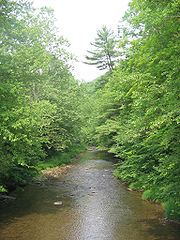
Larrys Creek is a 22.9 miles (36.9 km) tributary
of the West Branch Susquehanna River
in Lycoming County
in the U.S. state
of Pennsylvania
. A part of the Chesapeake Bay
drainage basin
, its watershed drains 89.1 mi2 in six townships
and a borough. The creek flows south from the dissected
Allegheny Plateau
to the Ridge-and-valley Appalachians
through sandstone, limestone, and shale from the Devonian
, Mississippian, and Pennsylvanian
periods.
The valley's first recorded inhabitants were the Susquehannock
s, followed by the Lenape
and other tribes. The Great Shamokin Path
crossed the creek near its mouth, where Larry Burt, the first Euro-American settler and the man who gave the creek its present name, also lived by 1769. In the 19th century, the creek and its watershed were a center for logging and related industries, including 53 sawmills, grist mills
, leather tanneries
, coal and iron mines. A 1903 newspaper article claimed "No other stream in the country had so many mills in so small a territory". For transportation, a plank road
ran along much of the creek for decades, and two "paper railroad
s" were planned, but never built.
As of 2006, the Larrys Creek watershed is 83.1% forest and 15.7% agricultural (a reforestation of land clear-cut in the 19th century). Nearly 9000 acres (3,642.2 ha) of second-growth forest are protected
public and private land for hunting
and trout fishing
, with more land protected in parts of Tiadaghton State Forest
. Pollution from past industrial use is gone and Larrys Creek "has an exceptionally scenic, ultra-highwater, whitewater run" for canoeing
. Despite agricultural runoff
and small amounts of acid mine drainage
, water quality is quite good, and a water filtration plant
on Larrys Creek supplies over 2500 customers.
of Larrys Creek in Piatt Township
. He traded with the indigenous peoples
, and, according to a tradition reported by Meginness (1892), he had a Native American
wife. Larry Burt was already there when surveyors came through in 1769 (after the land was purchased by the colonial government of Pennsylvania on November 5, 1768 as part of the "New Purchase" in the first Treaty of Fort Stanwix
), but disappeared sometime soon after, perhaps moving west with the Native Americans who left the area.
Larrys Creek is the only major creek in Lycoming County for which a Native American name is unknown. As of 2006, it is the only stream named "Larrys Creek" on USGS maps of the United States and in the USGS Geographic Names Information System
. The possessive apostrophe
is not part of the official name of the creek, although records from the 19th century often spell it as "Larry's Creek" (as do some highway bridge signs today).
Today the creek has given its name to the hamlet at its mouth, as well as the village of "Larryville" further upstream. Before it became a borough, Salladasburg was also known as "Larrys Creek" (from the name of its post office). The "First Fork" and "Second Fork" of Larrys Creek are named in the order in which they are encountered traveling upstream, with "Fork" here denoting a major tributary. "Lawshe Run", the major tributary of the Second Fork, is named for Robert Lawshe, who established a tannery in Salladasburg in 1848. "Seeley Run", a minor tributary entering the creek at Larryville, is named for Mr. Seely, who built the first sawmill on Larrys Creek in 1796. While the USGS uses "Seeley Run", it is still "Seely Run Road" that follows the stream. The First Fork, Canoe Run, Joes Run, and Wolf Run also have roads named for them.
. It is 53 miles (85.3 km) from the mouth of Larrys Creek along the West Branch Susquehanna River to its confluence with the Susquehanna River
at Northumberland, Pennsylvania
. The source
of Larrys Creek is in northern Lycoming County in Cogan House Township
, just south of the hamlet of Steam Valley, at an elevation of 1740 feet (530.4 m) It flows west-southwest through the village of Cogan House, and then under the Cogan House Covered Bridge
.
The creek next heads due south through Pennsylvania State Game Lands
Number 114. There it runs for about 3 miles (4.8 km) with only a trail or unimproved road beside it. It passes through Mifflin Township
for a short distance and heads southeast into Anthony Township
, where it leaves the State Game Lands and passes a water filtration plant; there is a dam 8.5 feet (2.6 m) tall and 52.5 feet (16 m) wide here. Further south, it receives Roaring Run (on the left bank). Roaring Run receives the only acid mine drainage in the watershed and enters Larrys Creek 10.4 miles (16.7 km) from the mouth.
Larrys Creek then heads southwest back into Mifflin Township, where it passes through the borough of Salladasburg, with Pennsylvania Route 973
running parallel to the creek from the township line to the borough. At Salladasburg, Larrys Creek receives its major tributary, the Second Fork of Larrys Creek, on the right bank 5.8 miles (9.3 km) from the mouth.
The Second Fork rises in Cogan House Township near the village of White Pine and runs south through the village of Brookside, then a few miles through Cummings Township
, and last through Mifflin Township and Salladasburg. Lawshe Run is its major tributary. Pennsylvania Route 287
runs parallel to the Second Fork its whole length, and continues parallel to Larrys Creek from Salladasburg south to its terminus on U.S. Route 220
(near the creek's mouth).
Just south of Salladasburg, Larrys Creek receives the First Fork of Larrys Creek, 4.2 miles (6.8 km) from the mouth. The First Fork has its source in Cummings Township and flows south-southeast into Mifflin Township. 2.8 miles (4.5 km) from its mouth Larrys Creek receives Canoe Run. Both these tributaries enter on the right bank.
Larrys Creek then enters Piatt Township, flowing east around a ridge and through the village of Larryville where it receives Seeley Run on the left bank, 1.5 miles (2.4 km) from the mouth. It next flows back southwest, then south to the hamlet of Larrys Creek and finally into the West Branch Susquehanna River, 2.6 miles (4.2 km) east of the borough of Jersey Shore
, at an elevation of 515 feet (157 m). U.S. Route 220 and the Lycoming Valley Railroad
cross the creek on separate bridges just north of its mouth. The direct distance between the source and mouth is only 16.9 miles (27.2 km). The difference in elevation between source and mouth, 1225 feet (373.4 m), divided by the length of the creek, 22.9 miles (36.9 km), gives the average drop in elevation per unit length of creek or relief ratio
of 53.5 feet per mile (10.1 m/km). The meander ratio
is 1.08, so the creek is fairly straight in its bed.
(USGS) operated one stream gauge
on Larrys Creek at the village of Cogan House, for the uppermost 6.8 mi2 of the watershed. The mean discharge
measured at this site from 1961 to 1978 was 10.8 cubic feet per second (0.306 m³/s), with a peak discharge of 1,130 cubic feet per second (32.0 m³/s) and peak gauge height of 5.29 feet (1.6 m), both on June 22, 1972 during Hurricane Agnes
. The USGS also estimated mean monthly and annual groundwater recharge at the Cogan House stream gauge. Using data from 1961 to 1977, the upper and lower annual recharge estimates were 18.1 to 14.5 in (46 to 36.8 cm), and the greatest monthly recharge was in March, with 20.1% of the annual total.
The USGS also measured discharge at the village of Larrys Creek, very near the creek's mouth, as part of water quality measurements on seven occasions between 1970 and 1975. The average discharge was 66.0 cubic feet per second (1.87 m3/s), and ranged from a high of 114 cubic feet per second (3.23 m3/s) to a low of 8.8 cubic feet per second (0.25 m3/s). Lycoming County operates a stream gauge at Salladasburg as part of the county-wide flood warning system. It only measures the water height (not discharge) and had a peak gauge height of 8 feet (2.4 m), on September 18, 2004 during Hurricane Ivan
.
 Larrys Creek is in a sandstone
, limestone
, and shale
mountain region, with the source in the dissected Allegheny Plateau and the mouth in the Ridge-and-valley Appalachians. The southern part of the Larrys Creek watershed has sedimentary surface rocks from the Devonian period, with a large area from the Mississippian period in the north of the watershed and a small Pennsylvanian period region within this area. The Cogan House anticline
runs north of and parallel to the upper part of the creek. Iron ore within the watershed was mined south of Salladasburg and along Canoe Run in the 19th century; there are also deposits on Puterbaugh Mountain.
Larrys Creek is in a narrow valley formed by mountains and hills, with steep to moderate slopes. The channel
pattern is regular, with a dendritic drainage pattern. After leaving its source, the creek turns to flow southwest along the northern edge of Green Mountain, turns south into the State Game Lands at Buckhorn Mountain, and flows south along the western edge of Coal Mountain. The only named peak on the west bank of Larrys Creek itself is Harris Point, where it leaves the dissected Allegheny Plateau.
The Second Fork flows south along the eastern side of Henson Ridge, then east of Puterbaugh Mountain. The only named peak on the east bank of the Second Fork is Clapp Point, which marks the boundary of the dissected plateau and is southwest of Harris Point. The First Fork flows past the southwest edge of Little Round Top and then continues on the southwest side of Puterbaugh Mountain. Fishery Point is at the southern end of the Allegheny Plateau, just west of the First Fork. The three features named Point are each part of the Allegheny Front
, the edge of the Allegheny Plateau.
The Larrys Creek watershed has two deposits of low volatile bituminous coal along Roaring Run and a small, deep natural gas
field. A potentially large source of natural gas is the Marcellus Shale, which lies 1.5 to 2 mi (2.4 to 3.2 km) below the surface here and stretches from New York
through Pennsylvania to Ohio
and West Virginia
. Estimates of the total natural gas in the black shale from the Devonian era range from 168 to 516 trillion cubic feet (4.76 to 14.6 trillion m3), with at least 10 percent considered recoverable. In November 2007, drilling within the Larrys Creek watershed started in Mifflin Township, just west of Salladasburg, with a 1.5 miles (2.4 km) deep well. A second well was drilled in Mifflin Township in December 2007, and by February 2008 every well drilled in Lycoming County was producing natural gas. The Marcellus Shale requires special techniques to fracture the rock and release the gas, including pumping sand and water into the well, and, in some cases, horizontal drilling.
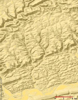
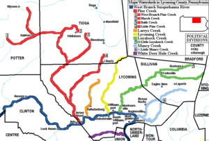
 The Larrys Creek watershed is entirely in Lycoming County and accounts for 7.17% of the county by area. It is the only major creek whose watershed is entirely in the county, and lies between the Pine Creek
watershed (including Little Pine Creek
) 5.2 miles (8.4 km) to the west and the Lycoming Creek
watershed 11.9 miles (19.2 km) to the east (as measured on the river).
The Larrys Creek watershed has a total population of 2,513 (as of 2000) and a total area of 89.1 mi2. Of that area, 74 mi2 are forested and 14 mi2 are given to agricultural uses. Larrys Creek is the largest creek in Lycoming County without its own watershed association.
Starting at the mouth, the tributaries of Larrys Creek are: Seeley Run, Canoe Run, First Fork Larrys Creek, Second Fork Larrys Creek, Mash Run, "Pond Hollow", "Spook Hollow", Roaring Run, "Cramer Hollow", "Pot Lick Hollow", "Match Pine Hollow", "Watt Hollow", Long Run, Wendell Run, Crayton Hollow Run, Wolf Run, Dibber Hollow Run, and Birch Run (unnamed streams in a named feature are given as the name of the feature in quotation marks).
 The clear-cutting of forests in the 19th century adversely affected the ecology of the Larrys Creek watershed and its water quality. Polluting industries on the creek and its tributaries during that period included coal and iron mines and tanneries. As of 2006, water quality in Larrys Creek is quite good, although two small unnamed tributaries of Roaring Run do receive acid mine drainage from an abandoned coal mine. Agricultural runoff is another source of pollution. Effluent limits for Larrys Creek in Mifflin Township for the 5-day test for carbonaceous biochemical oxygen demand (CBOD5) are 25 mg/L, while fecal coliform bacteria count limits are 200 per 100 mL in May through September, and 2000 per 100 mL in October through April.
The mean annual precipitation
for Larrys Creek is 40 to 42 in (1,016 to 1,066.8 mm). According to the Pennsylvania Fish and Boat Commission
: "Pennsylvania receives the most acid deposition
of any state in the nation because, in addition to being the third highest producer of the gases that cause acid deposition, we are also located downwind from the highest concentration of air pollution emitters." The region's geology gives it a relatively low capacity to neutralize added acid. This makes the creek especially vulnerable to increased acidification from rain, which poses a threat to the long term health of the plants and animals in the creek.
The Jersey Shore
Area Joint Water Authority’s water filtration plant is on Larrys Creek, near the border between Mifflin and Anthony Townships. The plant has been there since at least 1914 and provides water from the creek to 2,500 industrial and residential customers in the boroughs of Jersey Shore and Salladasburg, as well as Anthony, Mifflin, Nippenose, Piatt, and Porter Townships
in southwestern Lycoming County, and Pine Creek Township
in the southeastern part of neighboring Clinton County, Pennsylvania
.
 There are at least two camps along Larrys Creek. "Camp Kiwanis
" has a main lodge, four cabins, picnic pavilion, and various recreational facilities on 50 acres (20.2 ha) on Route 287, 1 miles (1.6 km) south of Salladasburg in Mifflin Township. It is operated as a service by the Williamsport
Kiwanis and rented out for fire department training, Girl Scouts, weddings, church, and other groups. Further south along the creek in Piatt Township is the New Tribes Mission
camp for preparing Christian
missionaries
for field work with indigenous peoples
in remote parts of the world. The training at the camp lasts one year.
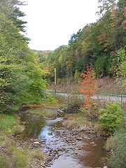
Edward Gertler writes in Keystone Canoeing that Larrys Creek "has an exceptionally scenic, ultra-highwater, whitewater run that is really worthy of your attention". Canoeing and kayak
ing on Larrys Creek are possible when the water is high enough (in Spring and after hard rain), with 8 miles (12.9 km) of Class 3 whitewater
on the International Scale of River Difficulty
from Township Road 786 south through the State Game Lands to Route 973, and 7.4 miles (11.9 km) of Class 1 to 2 whitewater south from PA 973 to U.S. 220.
In addition to the 2881 acres (1,165.9 ha) in State Game Lands No. 114, opportunities for hunting and fishing are available in the areas of Tiadaghton State Forest in the western part of the watershed, along the First and Second Forks. In 2002, a Pennsylvania Department of Conservation and Natural Resources
(DCNR) report on "State Forest Waters with Special Protection" rated the First Fork as a "High Quality-Cold Water Fishery". A stretch of Larrys Creek from the water company filtration plant (near the border between Mifflin and Anthony Townships) to 1 miles (1.6 km) downstream of the confluence with the First Fork has been designated as approved trout
waters by the Pennsylvania Fish and Boat Commission
. This means the waters will be stocked with trout and may be fished during trout season.
There are also private hunting and fishing clubs and cabins along Larrys Creek and its tributaries. The largest is the "Larrys Creek Fish and Game Club", incorporated August 1, 1906, which owns over 6000 acres (2,428.1 ha) along Route 287 on the Second Fork. As of 2006, the club has 55 active and 15 honorary members (all male). The club promotes conservation and stocks its 7 miles (11.3 km) of trout stream with three to four thousand brook and brown trout each year. The club's facilities include a trapshooting range and a helipad
, to aid in medical evacuations from its remote location.
Another large private club is the Ogontz Lodge on the First Fork, established by banker Jay Cooke
about 1884 for fishing and hunting. Cooke owned nearly the whole First Fork, 9.2 miles (14.8 km) long, with the main "Lodge" 1.2 miles (1.9 km) from the mouth, and a smaller "Upper Cabin" 5 miles (8 km) upstream of that. Herbert Hoover
found solitude at the Ogontz Lodge as a guest of Jay Cooke III three times: in June, 1918 (just before leaving for Europe as head of the American Food Administration), mid-May, 1928 (just before his selection as the Republican presidential candidate), and finally in late May, 1930 (as President of the United States
). Other notable guests at the Ogontz Lodge include Theodore Roosevelt, Jr.
and Katharine Hepburn
, and it is still in operation as of 2007.
 Two Clovis point
s found in the Salladasburg area in a "stream site" are the earliest evidence of human activity along Larrys Creek (circa 10,000 BCE
). The earliest recorded inhabitants of the Susquehanna River valley were the Iroquoian
speaking Susquehannock
s. Their name meant "people of the muddy river" in Algonquian
. Decimated by diseases and warfare, they had died out, moved away, or been assimilated
into other tribes by the early 18th century. The lands of the West Branch Susquehanna River Valley were then chiefly occupied by the Munsee phratry
of the Lenape
(or Delaware), and were under the nominal control of the Five (later Six) Nations of the Iroquois
. The Great Shamokin Path crossed the creek at a ford
near its mouth; however, no trails of the indigenous peoples are recorded as having followed Larrys Creek north.
On November 5, 1768, the British
acquired the "New Purchase" from the Iroquois in the Treaty of Fort Stanwix
, opening what is now Lycoming County to settlement. However, the Line of Property
(or Purchase Line
) border defined by "Tiadaghton Creek" dividing colonial and Native American lands was disputed. The colonists claimed this was Pine Creek, the Iroquois and other tribes that it was Lycoming Creek. Larrys Creek was in the disputed territory between these, so the illegal settlers there were part of the "Fair Play Men
" system of self-government, with their own Declaration of Independence from Britain on July 4, 1776.
In the Revolutionary War
, settlements throughout the Susquehanna valley were attacked by Loyalists
and Native Americans allied with the British. After the Wyoming Valley battle and massacre in the summer of 1778 (near what is now Wilkes-Barre
) and smaller local attacks, the "Big Runaway" occurred throughout the West Branch Susquehanna valley. Settlers fled feared and actual attacks by the British and their allies. Homes and fields were abandoned, with livestock driven along and a few possessions floated on rafts on the river east to Muncy
, then further south to Sunbury
. The abandoned property was burnt by the attackers. Some settlers soon returned, only to flee again in the summer of 1779 in the "Little Runaway". Sullivan's Expedition helped stabilize the area and encouraged resettlement, which continued after the war.
On April 13, 1795, Lycoming County was formed from Northumberland County
, prompting further growth. In 1800, the "State Road" was the second major road built in the county and followed part of Larrys Creek in Cogan House Township as it ran from Newberry (the western part of Williamsport today) north to the Pennsylvania-New York
state line near Painted Post, New York
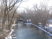
. Larrys Creek had a bridge near the mouth by 1806, the first of the major creeks in the county for which a bridge is mentioned.
 Like all creeks in Lycoming County, Larrys Creek served as an area for settlers to establish homesteads
and farms. As logging became a major industry in the mid-19th century, the creek was a source of power for sawmill
s and other mills. The first sawmill on the creek, in what is now Mifflin Township, was built in 1799. The relatively low flow of water in the creek did not allow rafts of logs to be floated downstream to the river and the lumber boom at Williamsport (as they were on Pine Creek to the west).
This and the lack of logging railroads along the creek led to the development of many small sawmills: the Larrys Creek watershed once had 53 sawmills within 22 miles (35.4 km) of the mouth (as well as other industries of the time). No other stream in the country had so many sawmills in so small a territory. Twelve sawmills were on the Second Fork, six on the First Fork, one each on Canoe Run and Lawshe Run, and the rest were on Larrys Creek itself. Eight were structures rebuilt on the site of previous sawmills, and only four were steam powered (the rest were water powered). The earliest of these sawmills was built in 1796 (near Seeley Run), the last in 1902 (on Lawshe Run), and by 1903 just two mills were still standing and only one of those was operating.
Lumbering removed the tree trunks, but left many flammable limbs, branches, and stumps behind. On May 2, 1872, a large forest fire destroyed the villages of Carter and Gould, 6 miles (9.7 km) north of Salladasburg on Larrys Creek in Mifflin Township. There are large tracts of second growth forest and small lumber companies still operate in the watershed today.
or Long Run, and thence to the New York state line. Its charter was amended April 4, 1854 to run up Marsh Creek
(then known as the Third Fork Pine Creek) and Crooked Creek
to the Tioga Railroad, and again on March 26, 1856 to run up Little Pine Creek (then known as First Fork Pine Creek) to the Larrys Creek Plank Road and then up Blockhouse Creek to Blossburg
. It was still an active corporation in 1865, but the charter of the "Jersey Shore, Pine Creek and Buffalo Railway
" in 1870 (New York City-Reading interests) superseded it. Neither railroad was actually ever built. The only railroad in the watershed crosses the creek just north of the mouth.
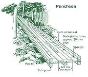 In 1851 a plank road
or puncheon was built along Larrys Creek from the village of Larrys Creek at the creek's mouth north to Salladasburg, then later along the Second Fork and on to the village of Brookside in Cogan House Township. It was later extended north to the village of White Pine and finally to the village of English Center in Pine Township
(along the current course of Pennsylvania Route 287
). A spur of the plank road along Larrys Creek into Anthony Township was also built, but it is not known how far it extended. (Landis claims it may have run nearly as far north as the covered bridge in Cogan House Township).
The plank road was a toll road
run by "The Larrys Creek Plank Road Company", a corporation founded May 8, 1850. It served the sawmills, grist mills, mines, and leather tanneries along the creek. There was a connection to the railroad and the West Branch Division of the Pennsylvania Canal
at the hamlet of Larrys Creek, as well as the West Branch Susquehanna River.
Hemlock
logs were used to build the plank road. At that time, the tree's bark was a major source of tannin
used to tan
leather. The wood was not used much for lumber, so hundreds of thousands of stripped hemlock logs were normally left to rot. There were sawmills and experienced lumber workers available from the local timber industry.
The earth under the plank road was first graded, then ties (similar to those used for railroad tracks) were set into the ground. Next long narrow stringers (similar to rails on a railroad track) were nailed to the ties, with a distance between stringers of about 6 feet (1.8 m). The road surface consisted of planks about 8 feet (2.4 m) wide nailed to the stringers and was fairly smooth. The road had turnoffs (as it was not wide enough for horse drawn vehicles to pass each other). Toll house
s were at regular intervals, with variable tolls for pedestrians, riders on horseback and various carts and wagons. No toll schedule has survived.
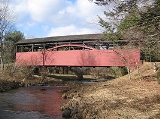
The plank road was operational for about 38 years when a major flood on June 1, 1889 washed out much of it. The flood also destroyed the canal at the creek's mouth. The same storm system caused the Johnstown Flood
, which killed over 2200 people. The Cogan House Covered Bridge was the only one on Larrys Creek to survive the flood, as a fallen tree formed a protective dam just upstream. The 90 foot (27 m) long Burr arch truss
bridge was built in 1877, listed on the National Register of Historic Places
in 1980, rehabilitated in 1998, and is today one of just three left in the county.
 By then most of the original forests in the county had been clear-cut, so no cheap source of wood was available as before. While the road from Salladasburg south to the West Branch Susquehanna River was repaired and rebuilt, the rest was not. In 1900 the county courts recognized a petition
to end tolls on this last portion of the road. The corporation was dissolved and the road and its maintenance passed to the county. As sections of plank road wore out they were replaced by graded dirt
and gravel
, so that it soon became a regular road. The plank road operated as a toll road for about 49 years. Today only the "Plank Road" name survives, in a 0.6 mile (0.965604 km) section of road that runs north from U.S. Route 220, parallel to Route 287.
Tributary
A tributary or affluent is a stream or river that flows into a main stem river or a lake. A tributary does not flow directly into a sea or ocean...
of the West Branch Susquehanna River
West Branch Susquehanna River
The West Branch Susquehanna River is one of the two principal branches, along with the North Branch, of the Susquehanna River in the northeastern United States. The North Branch, which rises in upstate New York, is generally regarded as the extension of the main branch, with the shorter West Branch...
in Lycoming County
Lycoming County, Pennsylvania
-Appalachian Mountains and Allegheny Plateau:Lycoming County is divided between the Appalachian Mountains in the south, the dissected Allegheny Plateau in the north and east, and the valley of the West Branch Susquehanna River between these.-West Branch Susquehanna River:The West Branch of the...
in the U.S. state
U.S. state
A U.S. state is any one of the 50 federated states of the United States of America that share sovereignty with the federal government. Because of this shared sovereignty, an American is a citizen both of the federal entity and of his or her state of domicile. Four states use the official title of...
of Pennsylvania
Pennsylvania
The Commonwealth of Pennsylvania is a U.S. state that is located in the Northeastern and Mid-Atlantic regions of the United States. The state borders Delaware and Maryland to the south, West Virginia to the southwest, Ohio to the west, New York and Ontario, Canada, to the north, and New Jersey to...
. A part of the Chesapeake Bay
Chesapeake Bay
The Chesapeake Bay is the largest estuary in the United States. It lies off the Atlantic Ocean, surrounded by Maryland and Virginia. The Chesapeake Bay's drainage basin covers in the District of Columbia and parts of six states: New York, Pennsylvania, Delaware, Maryland, Virginia, and West...
drainage basin
Drainage basin
A drainage basin is an extent or an area of land where surface water from rain and melting snow or ice converges to a single point, usually the exit of the basin, where the waters join another waterbody, such as a river, lake, reservoir, estuary, wetland, sea, or ocean...
, its watershed drains 89.1 mi2 in six townships
Township (Pennsylvania)
A township in the Commonwealth of Pennsylvania, a state of the United States of America, is one of four types of municipalities in the state . Townships were established based on convenient geographical boundaries and vary in size from six to forty square miles...
and a borough. The creek flows south from the dissected
Dissected plateau
A dissected plateau is a plateau area that has been severely eroded so that the relief is sharp. Such an area may be referred to as mountainous, but dissected plateaus are distinguishable from orogenic mountain belts by the lack of folding, metamorphism, extensive faulting, or magmatic activity...
Allegheny Plateau
Allegheny Plateau
The Allegheny Plateau is a large dissected plateau area in western and central New York, northern and western Pennsylvania, northern and western West Virginia, and eastern Ohio...
to the Ridge-and-valley Appalachians
Ridge-and-valley Appalachians
The Ridge-and-Valley Appalachians, also called the Ridge and Valley Province or the Valley and Ridge Appalachians, are a physiographic province of the larger Appalachian division and are also a belt within the Appalachian Mountains extending from southeastern New York through northwestern New...
through sandstone, limestone, and shale from the Devonian
Devonian
The Devonian is a geologic period and system of the Paleozoic Era spanning from the end of the Silurian Period, about 416.0 ± 2.8 Mya , to the beginning of the Carboniferous Period, about 359.2 ± 2.5 Mya...
, Mississippian, and Pennsylvanian
Pennsylvanian
The Pennsylvanian is, in the ICS geologic timescale, the younger of two subperiods of the Carboniferous Period. It lasted from roughly . As with most other geochronologic units, the rock beds that define the Pennsylvanian are well identified, but the exact date of the start and end are uncertain...
periods.
The valley's first recorded inhabitants were the Susquehannock
Susquehannock
The Susquehannock people were Iroquoian-speaking Native Americans who lived in areas adjacent to the Susquehanna River and its tributaries from the southern part of what is now New York, through Pennsylvania, to the mouth of the Susquehanna in Maryland at the north end of the Chesapeake Bay...
s, followed by the Lenape
Lenape
The Lenape are an Algonquian group of Native Americans of the Northeastern Woodlands. They are also called Delaware Indians. As a result of the American Revolutionary War and later Indian removals from the eastern United States, today the main groups live in Canada, where they are enrolled in the...
and other tribes. The Great Shamokin Path
Great Shamokin Path
The Great Shamokin Path was a major Native American trail in the U.S. State of Pennsylvania that ran from the native village of Shamokin along the left bank of the West Branch Susquehanna River north and then west to the Great Island...
crossed the creek near its mouth, where Larry Burt, the first Euro-American settler and the man who gave the creek its present name, also lived by 1769. In the 19th century, the creek and its watershed were a center for logging and related industries, including 53 sawmills, grist mills
Gristmill
The terms gristmill or grist mill can refer either to a building in which grain is ground into flour, or to the grinding mechanism itself.- Early history :...
, leather tanneries
Tanning
Tanning is the making of leather from the skins of animals which does not easily decompose. Traditionally, tanning used tannin, an acidic chemical compound from which the tanning process draws its name . Coloring may occur during tanning...
, coal and iron mines. A 1903 newspaper article claimed "No other stream in the country had so many mills in so small a territory". For transportation, a plank road
Plank road
A plank road or puncheon is a dirt path or road covered with a series of planks, similar to the wooden sidewalks one would see in a Western movie. Plank roads were very popular in Ontario, the U.S. Northeast and U.S. Midwest in the first half of the 19th century...
ran along much of the creek for decades, and two "paper railroad
Paper railroad
In the United States, a paper railroad is a company in the railroad business which exists "on paper only": as a legal entity which does not own any track, locomotives, or rolling stock. Frequently, paper railroads were set up as subsidiaries by larger parent railroads, or formerly existed and...
s" were planned, but never built.
As of 2006, the Larrys Creek watershed is 83.1% forest and 15.7% agricultural (a reforestation of land clear-cut in the 19th century). Nearly 9000 acres (3,642.2 ha) of second-growth forest are protected
Protected area
Protected areas are locations which receive protection because of their recognised natural, ecological and/or cultural values. There are several kinds of protected areas, which vary by level of protection depending on the enabling laws of each country or the regulations of the international...
public and private land for hunting
Hunting
Hunting is the practice of pursuing any living thing, usually wildlife, for food, recreation, or trade. In present-day use, the term refers to lawful hunting, as distinguished from poaching, which is the killing, trapping or capture of the hunted species contrary to applicable law...
and trout fishing
Fishing
Fishing is the activity of trying to catch wild fish. Fish are normally caught in the wild. Techniques for catching fish include hand gathering, spearing, netting, angling and trapping....
, with more land protected in parts of Tiadaghton State Forest
Tiadaghton State Forest
Tiadaghton State Forest is a Pennsylvania State Forest in Pennsylvania Bureau of Forestry District #12. The forest is chiefly in western and southern Lycoming County, with small portions in Clinton, Potter, Tioga, and Union counties....
. Pollution from past industrial use is gone and Larrys Creek "has an exceptionally scenic, ultra-highwater, whitewater run" for canoeing
Canoeing
Canoeing is an outdoor activity that involves a special kind of canoe.Open canoes may be 'poled' , sailed, 'lined and tracked' or even 'gunnel-bobbed'....
. Despite agricultural runoff
Surface runoff
Surface runoff is the water flow that occurs when soil is infiltrated to full capacity and excess water from rain, meltwater, or other sources flows over the land. This is a major component of the water cycle. Runoff that occurs on surfaces before reaching a channel is also called a nonpoint source...
and small amounts of acid mine drainage
Acid mine drainage
Acid mine drainage , or acid rock drainage , refers to the outflow of acidic water from metal mines or coal mines. However, other areas where the earth has been disturbed may also contribute acid rock drainage to the environment...
, water quality is quite good, and a water filtration plant
Water supply
Water supply is the provision of water by public utilities, commercial organisations, community endeavours or by individuals, usually via a system of pumps and pipes...
on Larrys Creek supplies over 2500 customers.
Name
Larrys Creek is named for Larry Burt, the first European settler in the area, who lived near the mouth of the creek outside what is now the hamletHamlet (place)
A hamlet is usually a rural settlement which is too small to be considered a village, though sometimes the word is used for a different sort of community. Historically, when a hamlet became large enough to justify building a church, it was then classified as a village...
of Larrys Creek in Piatt Township
Piatt Township, Pennsylvania
Piatt Township is a township in Lycoming County, Pennsylvania, in the United States. The population was 1,259 at the 2000 census. It is part of the Williamsport, Pennsylvania Metropolitan Statistical Area.-History:...
. He traded with the indigenous peoples
Indigenous peoples of the Americas
The indigenous peoples of the Americas are the pre-Columbian inhabitants of North and South America, their descendants and other ethnic groups who are identified with those peoples. Indigenous peoples are known in Canada as Aboriginal peoples, and in the United States as Native Americans...
, and, according to a tradition reported by Meginness (1892), he had a Native American
Native Americans in the United States
Native Americans in the United States are the indigenous peoples in North America within the boundaries of the present-day continental United States, parts of Alaska, and the island state of Hawaii. They are composed of numerous, distinct tribes, states, and ethnic groups, many of which survive as...
wife. Larry Burt was already there when surveyors came through in 1769 (after the land was purchased by the colonial government of Pennsylvania on November 5, 1768 as part of the "New Purchase" in the first Treaty of Fort Stanwix
Treaty of Fort Stanwix
The Treaty of Fort Stanwix was an important treaty between North American Indians and the British Empire. It was signed in 1768 at Fort Stanwix, located in present-day Rome, New York...
), but disappeared sometime soon after, perhaps moving west with the Native Americans who left the area.
Larrys Creek is the only major creek in Lycoming County for which a Native American name is unknown. As of 2006, it is the only stream named "Larrys Creek" on USGS maps of the United States and in the USGS Geographic Names Information System
Geographic Names Information System
The Geographic Names Information System is a database that contains name and locative information about more than two million physical and cultural features located throughout the United States of America and its territories. It is a type of gazetteer...
. The possessive apostrophe
Apostrophe
The apostrophe is a punctuation mark, and sometimes a diacritic mark, in languages that use the Latin alphabet or certain other alphabets...
is not part of the official name of the creek, although records from the 19th century often spell it as "Larry's Creek" (as do some highway bridge signs today).
Today the creek has given its name to the hamlet at its mouth, as well as the village of "Larryville" further upstream. Before it became a borough, Salladasburg was also known as "Larrys Creek" (from the name of its post office). The "First Fork" and "Second Fork" of Larrys Creek are named in the order in which they are encountered traveling upstream, with "Fork" here denoting a major tributary. "Lawshe Run", the major tributary of the Second Fork, is named for Robert Lawshe, who established a tannery in Salladasburg in 1848. "Seeley Run", a minor tributary entering the creek at Larryville, is named for Mr. Seely, who built the first sawmill on Larrys Creek in 1796. While the USGS uses "Seeley Run", it is still "Seely Run Road" that follows the stream. The First Fork, Canoe Run, Joes Run, and Wolf Run also have roads named for them.
Course
Larrys Creek is the only major watershed in Lycoming County entirely within the county. Measured directly, Lycoming County is about 130 miles (209.2 km) northwest of Philadelphia and 165 miles (265.5 km) east-northeast of PittsburghPittsburgh, Pennsylvania
Pittsburgh is the second-largest city in the US Commonwealth of Pennsylvania and the county seat of Allegheny County. Regionally, it anchors the largest urban area of Appalachia and the Ohio River Valley, and nationally, it is the 22nd-largest urban area in the United States...
. It is 53 miles (85.3 km) from the mouth of Larrys Creek along the West Branch Susquehanna River to its confluence with the Susquehanna River
Susquehanna River
The Susquehanna River is a river located in the northeastern United States. At long, it is the longest river on the American east coast that drains into the Atlantic Ocean, and with its watershed it is the 16th largest river in the United States, and the longest river in the continental United...
at Northumberland, Pennsylvania
Northumberland, Pennsylvania
Northumberland is a borough in Northumberland County, Pennsylvania, United States. The population was 3,714 at the 2000 census.-History:Northumberland was founded in 1772. The land that became Northumberland was purchased from the Iroquois in the first Treaty of Fort Stanwix in 1768, and the...
. The source
Source (river or stream)
The source or headwaters of a river or stream is the place from which the water in the river or stream originates.-Definition:There is no universally agreed upon definition for determining a stream's source...
of Larrys Creek is in northern Lycoming County in Cogan House Township
Cogan House Township, Pennsylvania
Cogan House Township is a township in Lycoming County, Pennsylvania, in the United States. The population was 974 at the 2000 census. It is part of the Williamsport, Pennsylvania Metropolitan Statistical Area.-History:...
, just south of the hamlet of Steam Valley, at an elevation of 1740 feet (530.4 m) It flows west-southwest through the village of Cogan House, and then under the Cogan House Covered Bridge
Cogan House Covered Bridge
The Cogan House Covered Bridge is a Burr arch truss covered bridge over Larrys Creek in Cogan House Township, Lycoming County in the U.S. state of Pennsylvania. It was built in 1877 and is long. The bridge was placed on the National Register of Historic Places in 1980, and had a major restoration...
.
The creek next heads due south through Pennsylvania State Game Lands
Pennsylvania State Game Lands
The Pennsylvania State Game Lands are lands managed by the Pennsylvania Game Commission for hunting, trapping, and fishing. These lands, often not usable for farming or development, are donated to the PGC or purchased by the PGC with hunting license monies.The Pennsylvania Game Commission runs a...
Number 114. There it runs for about 3 miles (4.8 km) with only a trail or unimproved road beside it. It passes through Mifflin Township
Mifflin Township, Lycoming County, Pennsylvania
Mifflin Township is a township in Lycoming County, Pennsylvania, in the United States. The population was 1,145 at the 2000 census. It is part of the Williamsport, Pennsylvania Metropolitan Statistical Area.- History :...
for a short distance and heads southeast into Anthony Township
Anthony Township, Lycoming County, Pennsylvania
Anthony Township is a township in Lycoming County, Pennsylvania, in the United States. The population was 904 at the 2000 census. It is part of the Williamsport, Pennsylvania Metropolitan Statistical Area.-History:...
, where it leaves the State Game Lands and passes a water filtration plant; there is a dam 8.5 feet (2.6 m) tall and 52.5 feet (16 m) wide here. Further south, it receives Roaring Run (on the left bank). Roaring Run receives the only acid mine drainage in the watershed and enters Larrys Creek 10.4 miles (16.7 km) from the mouth.
Larrys Creek then heads southwest back into Mifflin Township, where it passes through the borough of Salladasburg, with Pennsylvania Route 973
Pennsylvania Route 973
Pennsylvania Route 973 is a highway which runs for 26 miles generally east–west in Lycoming County in north central Pennsylvania in the United States...
running parallel to the creek from the township line to the borough. At Salladasburg, Larrys Creek receives its major tributary, the Second Fork of Larrys Creek, on the right bank 5.8 miles (9.3 km) from the mouth.
The Second Fork rises in Cogan House Township near the village of White Pine and runs south through the village of Brookside, then a few miles through Cummings Township
Cummings Township, Pennsylvania
Cummings Township is a township in Lycoming County, Pennsylvania, in the United States. The population was 355 at the 2000 census. It is part of the Williamsport, Pennsylvania Metropolitan Statistical Area...
, and last through Mifflin Township and Salladasburg. Lawshe Run is its major tributary. Pennsylvania Route 287
Pennsylvania Route 287
Pennsylvania Route 287 is a long state highway in the Tioga Valley of Pennsylvania. Route 287 begins at an intersection with U.S. Route 220 in the community of Larrys Creek in Piatt Township, Lycoming County to an intersection with Pennsylvania Route 49 just south of the New York state line...
runs parallel to the Second Fork its whole length, and continues parallel to Larrys Creek from Salladasburg south to its terminus on U.S. Route 220
U.S. Route 220
U.S. Route 220 is a long U.S. Route in the eastern United States.US 220 is a spur route of U.S. Route 20 but at present, the two routes do not intersect nor do they connect via other spurs of US 20. The former U. S. Route 120, which was signed in Pennsylvania between 1926 and 1967, intersected...
(near the creek's mouth).
Just south of Salladasburg, Larrys Creek receives the First Fork of Larrys Creek, 4.2 miles (6.8 km) from the mouth. The First Fork has its source in Cummings Township and flows south-southeast into Mifflin Township. 2.8 miles (4.5 km) from its mouth Larrys Creek receives Canoe Run. Both these tributaries enter on the right bank.
Larrys Creek then enters Piatt Township, flowing east around a ridge and through the village of Larryville where it receives Seeley Run on the left bank, 1.5 miles (2.4 km) from the mouth. It next flows back southwest, then south to the hamlet of Larrys Creek and finally into the West Branch Susquehanna River, 2.6 miles (4.2 km) east of the borough of Jersey Shore
Jersey Shore, Pennsylvania
Jersey Shore is a borough in Lycoming County, Pennsylvania, United States. It is on the West Branch Susquehanna River, west by south of Williamsport. It is part of the Williamsport, Pennsylvania Metropolitan Statistical Area. In the past, Jersey Shore held farms, railroad shops, cigar factories, a...
, at an elevation of 515 feet (157 m). U.S. Route 220 and the Lycoming Valley Railroad
Lycoming Valley Railroad
The Lycoming Valley Railroad is a short line that operates of track in Lycoming and Clinton counties in Pennsylvania in the United States. It is part of the North Shore Railroad System....
cross the creek on separate bridges just north of its mouth. The direct distance between the source and mouth is only 16.9 miles (27.2 km). The difference in elevation between source and mouth, 1225 feet (373.4 m), divided by the length of the creek, 22.9 miles (36.9 km), gives the average drop in elevation per unit length of creek or relief ratio
Relief ratio
The relief ratio is a number calculated to describe the Grade of a river or stream.The calculation is just the difference in elevation between the river's source and the river's confluence or mouth divided by the total length of the river or stream. This gives the average drop in elevation per...
of 53.5 feet per mile (10.1 m/km). The meander ratio
Meander
A meander in general is a bend in a sinuous watercourse. A meander is formed when the moving water in a stream erodes the outer banks and widens its valley. A stream of any volume may assume a meandering course, alternately eroding sediments from the outside of a bend and depositing them on the...
is 1.08, so the creek is fairly straight in its bed.
Discharge
From 1960 to 1979, the United States Geological SurveyUnited States Geological Survey
The United States Geological Survey is a scientific agency of the United States government. The scientists of the USGS study the landscape of the United States, its natural resources, and the natural hazards that threaten it. The organization has four major science disciplines, concerning biology,...
(USGS) operated one stream gauge
Stream gauge
A stream gauge, stream gage or gauging station is a location used by hydrologists or environmental scientists to monitor and test terrestrial bodies of water. Hydrometric measurements of water surface elevation and/or volumetric discharge are generally taken and observations of biota may also be...
on Larrys Creek at the village of Cogan House, for the uppermost 6.8 mi2 of the watershed. The mean discharge
Discharge (hydrology)
In hydrology, discharge is the volume rate of water flow, including any suspended solids , dissolved chemical species and/or biologic material , which is transported through a given cross-sectional area...
measured at this site from 1961 to 1978 was 10.8 cubic feet per second (0.306 m³/s), with a peak discharge of 1,130 cubic feet per second (32.0 m³/s) and peak gauge height of 5.29 feet (1.6 m), both on June 22, 1972 during Hurricane Agnes
Hurricane Agnes
Hurricane Agnes was the first tropical storm and first hurricane of the 1972 Atlantic hurricane season. A rare June hurricane, it made landfall on the Florida Panhandle before moving northeastward and ravaging the Mid-Atlantic region as a tropical storm...
. The USGS also estimated mean monthly and annual groundwater recharge at the Cogan House stream gauge. Using data from 1961 to 1977, the upper and lower annual recharge estimates were 18.1 to 14.5 in (46 to 36.8 cm), and the greatest monthly recharge was in March, with 20.1% of the annual total.
The USGS also measured discharge at the village of Larrys Creek, very near the creek's mouth, as part of water quality measurements on seven occasions between 1970 and 1975. The average discharge was 66.0 cubic feet per second (1.87 m3/s), and ranged from a high of 114 cubic feet per second (3.23 m3/s) to a low of 8.8 cubic feet per second (0.25 m3/s). Lycoming County operates a stream gauge at Salladasburg as part of the county-wide flood warning system. It only measures the water height (not discharge) and had a peak gauge height of 8 feet (2.4 m), on September 18, 2004 during Hurricane Ivan
Hurricane Ivan
Hurricane Ivan was a large, long-lived, Cape Verde-type hurricane that caused widespread damage in the Caribbean and United States. The cyclone was the ninth named storm, the sixth hurricane and the fourth major hurricane of the active 2004 Atlantic hurricane season...
.
Geology
Sandstone
Sandstone is a sedimentary rock composed mainly of sand-sized minerals or rock grains.Most sandstone is composed of quartz and/or feldspar because these are the most common minerals in the Earth's crust. Like sand, sandstone may be any colour, but the most common colours are tan, brown, yellow,...
, limestone
Limestone
Limestone is a sedimentary rock composed largely of the minerals calcite and aragonite, which are different crystal forms of calcium carbonate . Many limestones are composed from skeletal fragments of marine organisms such as coral or foraminifera....
, and shale
Shale
Shale is a fine-grained, clastic sedimentary rock composed of mud that is a mix of flakes of clay minerals and tiny fragments of other minerals, especially quartz and calcite. The ratio of clay to other minerals is variable. Shale is characterized by breaks along thin laminae or parallel layering...
mountain region, with the source in the dissected Allegheny Plateau and the mouth in the Ridge-and-valley Appalachians. The southern part of the Larrys Creek watershed has sedimentary surface rocks from the Devonian period, with a large area from the Mississippian period in the north of the watershed and a small Pennsylvanian period region within this area. The Cogan House anticline
Anticline
In structural geology, an anticline is a fold that is convex up and has its oldest beds at its core. The term is not to be confused with antiform, which is a purely descriptive term for any fold that is convex up. Therefore if age relationships In structural geology, an anticline is a fold that is...
runs north of and parallel to the upper part of the creek. Iron ore within the watershed was mined south of Salladasburg and along Canoe Run in the 19th century; there are also deposits on Puterbaugh Mountain.
Larrys Creek is in a narrow valley formed by mountains and hills, with steep to moderate slopes. The channel
Stream bed
A stream bed is the channel bottom of a stream, river or creek; the physical confine of the normal water flow. The lateral confines or channel margins, during all but flood stage, are known as the stream banks or river banks. In fact, a flood occurs when a stream overflows its banks and flows onto...
pattern is regular, with a dendritic drainage pattern. After leaving its source, the creek turns to flow southwest along the northern edge of Green Mountain, turns south into the State Game Lands at Buckhorn Mountain, and flows south along the western edge of Coal Mountain. The only named peak on the west bank of Larrys Creek itself is Harris Point, where it leaves the dissected Allegheny Plateau.
The Second Fork flows south along the eastern side of Henson Ridge, then east of Puterbaugh Mountain. The only named peak on the east bank of the Second Fork is Clapp Point, which marks the boundary of the dissected plateau and is southwest of Harris Point. The First Fork flows past the southwest edge of Little Round Top and then continues on the southwest side of Puterbaugh Mountain. Fishery Point is at the southern end of the Allegheny Plateau, just west of the First Fork. The three features named Point are each part of the Allegheny Front
Allegheny Front
The Allegheny Front is the major southeast- or east-facing escarpment in the Allegheny Mountains in southern Pennsylvania, western Maryland, and eastern West Virginia, USA. The Allegheny Front delineates the Ridge-and-Valley Appalachians to its east from the Appalachian Plateau to its west...
, the edge of the Allegheny Plateau.
The Larrys Creek watershed has two deposits of low volatile bituminous coal along Roaring Run and a small, deep natural gas
Natural gas
Natural gas is a naturally occurring gas mixture consisting primarily of methane, typically with 0–20% higher hydrocarbons . It is found associated with other hydrocarbon fuel, in coal beds, as methane clathrates, and is an important fuel source and a major feedstock for fertilizers.Most natural...
field. A potentially large source of natural gas is the Marcellus Shale, which lies 1.5 to 2 mi (2.4 to 3.2 km) below the surface here and stretches from New York
New York
New York is a state in the Northeastern region of the United States. It is the nation's third most populous state. New York is bordered by New Jersey and Pennsylvania to the south, and by Connecticut, Massachusetts and Vermont to the east...
through Pennsylvania to Ohio
Ohio
Ohio is a Midwestern state in the United States. The 34th largest state by area in the U.S.,it is the 7th‑most populous with over 11.5 million residents, containing several major American cities and seven metropolitan areas with populations of 500,000 or more.The state's capital is Columbus...
and West Virginia
West Virginia
West Virginia is a state in the Appalachian and Southeastern regions of the United States, bordered by Virginia to the southeast, Kentucky to the southwest, Ohio to the northwest, Pennsylvania to the northeast and Maryland to the east...
. Estimates of the total natural gas in the black shale from the Devonian era range from 168 to 516 trillion cubic feet (4.76 to 14.6 trillion m3), with at least 10 percent considered recoverable. In November 2007, drilling within the Larrys Creek watershed started in Mifflin Township, just west of Salladasburg, with a 1.5 miles (2.4 km) deep well. A second well was drilled in Mifflin Township in December 2007, and by February 2008 every well drilled in Lycoming County was producing natural gas. The Marcellus Shale requires special techniques to fracture the rock and release the gas, including pumping sand and water into the well, and, in some cases, horizontal drilling.
Watershed
Pine Creek (Pennsylvania)
Pine Creek is a tributary of the West Branch Susquehanna River in Potter, Tioga, Lycoming, and Clinton counties in Pennsylvania in the United States. The creek is long...
watershed (including Little Pine Creek
Little Pine Creek
Little Pine Creek is a tributary of Pine Creek in Lycoming County, Pennsylvania in the United States.Little Pine Creek is formed by the confluence of Blockhouse Creek and Texas Creek, approximately upstream of Pine Creek. Blacks Creek joins Blockhouse Creek approximately above. of Little Pine...
) 5.2 miles (8.4 km) to the west and the Lycoming Creek
Lycoming Creek
Lycoming Creek is a tributary of the West Branch Susquehanna River located in Tioga and Lycoming counties in Pennsylvania in the United States.-Geography:...
watershed 11.9 miles (19.2 km) to the east (as measured on the river).
The Larrys Creek watershed has a total population of 2,513 (as of 2000) and a total area of 89.1 mi2. Of that area, 74 mi2 are forested and 14 mi2 are given to agricultural uses. Larrys Creek is the largest creek in Lycoming County without its own watershed association.
Tributaries
The major smaller streams in the Larrys Creek watershed include the First and Second Forks, Roaring Run, Lawshe Run, and Canoe Run. The Second Fork is the largest tributary, with a watershed of 24.9 mi2 or 28.0% of the total watershed. The First Fork is next largest, with a watershed of 17.6 mi2 or 19.8% of the total. Roaring Run accounts for 5.7% of the total watershed with 5.1 mi2 and other tributaries are less than 5% of the total.Starting at the mouth, the tributaries of Larrys Creek are: Seeley Run, Canoe Run, First Fork Larrys Creek, Second Fork Larrys Creek, Mash Run, "Pond Hollow", "Spook Hollow", Roaring Run, "Cramer Hollow", "Pot Lick Hollow", "Match Pine Hollow", "Watt Hollow", Long Run, Wendell Run, Crayton Hollow Run, Wolf Run, Dibber Hollow Run, and Birch Run (unnamed streams in a named feature are given as the name of the feature in quotation marks).
Water quality, pollution, and filtration plant
The mean annual precipitation
Precipitation (meteorology)
In meteorology, precipitation In meteorology, precipitation In meteorology, precipitation (also known as one of the classes of hydrometeors, which are atmospheric water phenomena is any product of the condensation of atmospheric water vapor that falls under gravity. The main forms of precipitation...
for Larrys Creek is 40 to 42 in (1,016 to 1,066.8 mm). According to the Pennsylvania Fish and Boat Commission
Pennsylvania Fish and Boat Commission
The Pennsylvania Fish and Boat Commission is the state agency responsible for the regulation of all fishing and boating in the Commonwealth of Pennsylvania...
: "Pennsylvania receives the most acid deposition
Acid rain
Acid rain is a rain or any other form of precipitation that is unusually acidic, meaning that it possesses elevated levels of hydrogen ions . It can have harmful effects on plants, aquatic animals, and infrastructure. Acid rain is caused by emissions of carbon dioxide, sulfur dioxide and nitrogen...
of any state in the nation because, in addition to being the third highest producer of the gases that cause acid deposition, we are also located downwind from the highest concentration of air pollution emitters." The region's geology gives it a relatively low capacity to neutralize added acid. This makes the creek especially vulnerable to increased acidification from rain, which poses a threat to the long term health of the plants and animals in the creek.
The Jersey Shore
Jersey Shore, Pennsylvania
Jersey Shore is a borough in Lycoming County, Pennsylvania, United States. It is on the West Branch Susquehanna River, west by south of Williamsport. It is part of the Williamsport, Pennsylvania Metropolitan Statistical Area. In the past, Jersey Shore held farms, railroad shops, cigar factories, a...
Area Joint Water Authority’s water filtration plant is on Larrys Creek, near the border between Mifflin and Anthony Townships. The plant has been there since at least 1914 and provides water from the creek to 2,500 industrial and residential customers in the boroughs of Jersey Shore and Salladasburg, as well as Anthony, Mifflin, Nippenose, Piatt, and Porter Townships
Porter Township, Lycoming County, Pennsylvania
Porter Township is a township in Lycoming County, Pennsylvania, in the United States. The population was 1,633 at the 2000 census. It is part of the Williamsport, Pennsylvania Metropolitan Statistical Area.-History:Porter Township, named for David R...
in southwestern Lycoming County, and Pine Creek Township
Pine Creek Township, Clinton County, Pennsylvania
Pine Creek Township is a township in Clinton County, Pennsylvania, United States. The population was 3,184 at the 2000 census. Pine Creek Township is named for Pine Creek which flows into the West Branch Susquehanna River at the border of the township is Lycoming County between the boroughs of Avis...
in the southeastern part of neighboring Clinton County, Pennsylvania
Clinton County, Pennsylvania
As of the census of 2000, there were 37,914 people, 14,773 households, and 9,927 families residing in the county. The population density was 43 people per square mile . There were 18,166 housing units at an average density of 20 per square mile...
.
Recreation
Kiwanis
Kiwanis International is an international, coeducational service club founded in 1915. It is headquartered in Indianapolis, Indiana. Current membership is 240,000 members in 7,700 clubs in 80 nations...
" has a main lodge, four cabins, picnic pavilion, and various recreational facilities on 50 acres (20.2 ha) on Route 287, 1 miles (1.6 km) south of Salladasburg in Mifflin Township. It is operated as a service by the Williamsport
Williamsport, Pennsylvania
Williamsport is a city in and the county seat of Lycoming County, Pennsylvania in the United States. In 2009, the population was estimated at 29,304...
Kiwanis and rented out for fire department training, Girl Scouts, weddings, church, and other groups. Further south along the creek in Piatt Township is the New Tribes Mission
New Tribes Mission
New Tribes Mission is an international, theologically evangelical Christian mission organization based in Sanford, Florida, United States. NTM has approximately 3,300 missionaries in more than 20 nations, second only to Wycliffe Bible Translators/SIL International David Hesselgrave, Executive...
camp for preparing Christian
Christian
A Christian is a person who adheres to Christianity, an Abrahamic, monotheistic religion based on the life and teachings of Jesus of Nazareth as recorded in the Canonical gospels and the letters of the New Testament...
missionaries
Missionary
A missionary is a member of a religious group sent into an area to do evangelism or ministries of service, such as education, literacy, social justice, health care and economic development. The word "mission" originates from 1598 when the Jesuits sent members abroad, derived from the Latin...
for field work with indigenous peoples
Indigenous peoples
Indigenous peoples are ethnic groups that are defined as indigenous according to one of the various definitions of the term, there is no universally accepted definition but most of which carry connotations of being the "original inhabitants" of a territory....
in remote parts of the world. The training at the camp lasts one year.
Edward Gertler writes in Keystone Canoeing that Larrys Creek "has an exceptionally scenic, ultra-highwater, whitewater run that is really worthy of your attention". Canoeing and kayak
Kayak
A kayak is a small, relatively narrow, human-powered boat primarily designed to be manually propelled by means of a double blade paddle.The traditional kayak has a covered deck and one or more cockpits, each seating one paddler...
ing on Larrys Creek are possible when the water is high enough (in Spring and after hard rain), with 8 miles (12.9 km) of Class 3 whitewater
Whitewater
Whitewater is formed in a rapid, when a river's gradient increases enough to disturb its laminar flow and create turbulence, i.e. form a bubbly, or aerated and unstable current; the frothy water appears white...
on the International Scale of River Difficulty
International Scale of River Difficulty
The International Scale of River Difficulty is a standardized scale used to rate the safety of a stretch of river, or a single rapid. The grade reflects the technical difficulty and skill level required associated with the section of river...
from Township Road 786 south through the State Game Lands to Route 973, and 7.4 miles (11.9 km) of Class 1 to 2 whitewater south from PA 973 to U.S. 220.
In addition to the 2881 acres (1,165.9 ha) in State Game Lands No. 114, opportunities for hunting and fishing are available in the areas of Tiadaghton State Forest in the western part of the watershed, along the First and Second Forks. In 2002, a Pennsylvania Department of Conservation and Natural Resources
Pennsylvania Department of Conservation and Natural Resources
The Pennsylvania Department of Conservation and Natural Resources , established on July 1, 1995, is the agency in the U.S. State of Pennsylvania responsible for maintaining and preserving the state's 117 state parks and 20 state forests; providing information on the state's natural resources; and...
(DCNR) report on "State Forest Waters with Special Protection" rated the First Fork as a "High Quality-Cold Water Fishery". A stretch of Larrys Creek from the water company filtration plant (near the border between Mifflin and Anthony Townships) to 1 miles (1.6 km) downstream of the confluence with the First Fork has been designated as approved trout
Trout
Trout is the name for a number of species of freshwater and saltwater fish belonging to the Salmoninae subfamily of the family Salmonidae. Salmon belong to the same family as trout. Most salmon species spend almost all their lives in salt water...
waters by the Pennsylvania Fish and Boat Commission
Pennsylvania Fish and Boat Commission
The Pennsylvania Fish and Boat Commission is the state agency responsible for the regulation of all fishing and boating in the Commonwealth of Pennsylvania...
. This means the waters will be stocked with trout and may be fished during trout season.
There are also private hunting and fishing clubs and cabins along Larrys Creek and its tributaries. The largest is the "Larrys Creek Fish and Game Club", incorporated August 1, 1906, which owns over 6000 acres (2,428.1 ha) along Route 287 on the Second Fork. As of 2006, the club has 55 active and 15 honorary members (all male). The club promotes conservation and stocks its 7 miles (11.3 km) of trout stream with three to four thousand brook and brown trout each year. The club's facilities include a trapshooting range and a helipad
Helipad
Helipad is a common abbreviation for helicopter landing pad, a landing area for helicopters. While helicopters are able to operate on a variety of relatively flat surfaces, a fabricated helipad provides a clearly marked hard surface away from obstacles where a helicopter can safely...
, to aid in medical evacuations from its remote location.
Another large private club is the Ogontz Lodge on the First Fork, established by banker Jay Cooke
Jay Cooke
Jay Cooke was an American financier. Cooke and his firm Jay Cooke & Company were most notable for their role in financing the Union's war effort during the American Civil War...
about 1884 for fishing and hunting. Cooke owned nearly the whole First Fork, 9.2 miles (14.8 km) long, with the main "Lodge" 1.2 miles (1.9 km) from the mouth, and a smaller "Upper Cabin" 5 miles (8 km) upstream of that. Herbert Hoover
Herbert Hoover
Herbert Clark Hoover was the 31st President of the United States . Hoover was originally a professional mining engineer and author. As the United States Secretary of Commerce in the 1920s under Presidents Warren Harding and Calvin Coolidge, he promoted partnerships between government and business...
found solitude at the Ogontz Lodge as a guest of Jay Cooke III three times: in June, 1918 (just before leaving for Europe as head of the American Food Administration), mid-May, 1928 (just before his selection as the Republican presidential candidate), and finally in late May, 1930 (as President of the United States
President of the United States
The President of the United States of America is the head of state and head of government of the United States. The president leads the executive branch of the federal government and is the commander-in-chief of the United States Armed Forces....
). Other notable guests at the Ogontz Lodge include Theodore Roosevelt, Jr.
Theodore Roosevelt, Jr.
Theodore D. Roosevelt, Jr. , was an American political and business leader, a Medal of Honor recipient who fought in both of the 20th century's world wars. He was the eldest son of President Theodore Roosevelt from his second wife Edith Roosevelt...
and Katharine Hepburn
Katharine Hepburn
Katharine Houghton Hepburn was an American actress of film, stage, and television. In a career that spanned 62 years as a leading lady, she was best known for playing strong-willed, sophisticated women in both dramas and comedies...
, and it is still in operation as of 2007.
Early inhabitants
Clovis point
Clovis points are the characteristically-fluted projectile points associated with the North American Clovis culture. They date to the Paleoindian period around 13,500 years ago. Clovis fluted points are named after the city of Clovis, New Mexico, where examples were first found in 1929.At the right...
s found in the Salladasburg area in a "stream site" are the earliest evidence of human activity along Larrys Creek (circa 10,000 BCE
Common Era
Common Era ,abbreviated as CE, is an alternative designation for the calendar era originally introduced by Dionysius Exiguus in the 6th century, traditionally identified with Anno Domini .Dates before the year 1 CE are indicated by the usage of BCE, short for Before the Common Era Common Era...
). The earliest recorded inhabitants of the Susquehanna River valley were the Iroquoian
Iroquoian languages
The Iroquoian languages are a First Nation and Native American language family.-Family division:*Ruttenber, Edward Manning. 1992 [1872]. History of the Indian tribes of Hudson's River. Hope Farm Press....
speaking Susquehannock
Susquehannock
The Susquehannock people were Iroquoian-speaking Native Americans who lived in areas adjacent to the Susquehanna River and its tributaries from the southern part of what is now New York, through Pennsylvania, to the mouth of the Susquehanna in Maryland at the north end of the Chesapeake Bay...
s. Their name meant "people of the muddy river" in Algonquian
Algonquian languages
The Algonquian languages also Algonkian) are a subfamily of Native American languages which includes most of the languages in the Algic language family. The name of the Algonquian language family is distinguished from the orthographically similar Algonquin dialect of the Ojibwe language, which is a...
. Decimated by diseases and warfare, they had died out, moved away, or been assimilated
Cultural assimilation
Cultural assimilation is a socio-political response to demographic multi-ethnicity that supports or promotes the assimilation of ethnic minorities into the dominant culture. The term assimilation is often used with regard to immigrants and various ethnic groups who have settled in a new land. New...
into other tribes by the early 18th century. The lands of the West Branch Susquehanna River Valley were then chiefly occupied by the Munsee phratry
Phratry
In ancient Greece, a phratry ατρία, "brotherhood", "kinfolk", derived from φρατήρ meaning "brother") was a social division of the Greek tribe...
of the Lenape
Lenape
The Lenape are an Algonquian group of Native Americans of the Northeastern Woodlands. They are also called Delaware Indians. As a result of the American Revolutionary War and later Indian removals from the eastern United States, today the main groups live in Canada, where they are enrolled in the...
(or Delaware), and were under the nominal control of the Five (later Six) Nations of the Iroquois
Iroquois
The Iroquois , also known as the Haudenosaunee or the "People of the Longhouse", are an association of several tribes of indigenous people of North America...
. The Great Shamokin Path crossed the creek at a ford
Ford (crossing)
A ford is a shallow place with good footing where a river or stream may be crossed by wading or in a vehicle. A ford is mostly a natural phenomenon, in contrast to a low water crossing, which is an artificial bridge that allows crossing a river or stream when water is low.The names of many towns...
near its mouth; however, no trails of the indigenous peoples are recorded as having followed Larrys Creek north.
On November 5, 1768, the British
United Kingdom
The United Kingdom of Great Britain and Northern IrelandIn the United Kingdom and Dependencies, other languages have been officially recognised as legitimate autochthonous languages under the European Charter for Regional or Minority Languages...
acquired the "New Purchase" from the Iroquois in the Treaty of Fort Stanwix
Treaty of Fort Stanwix
The Treaty of Fort Stanwix was an important treaty between North American Indians and the British Empire. It was signed in 1768 at Fort Stanwix, located in present-day Rome, New York...
, opening what is now Lycoming County to settlement. However, the Line of Property
Line of Property
The Line of Property is the name commonly given to the line dividing Indian from British Colonial lands established in the Treaty of Fort Stanwix of 1768...
(or Purchase Line
Purchase line
The Purchase Line is the name commonly given to the line dividing Indian from British Colonial lands established in the Treaty of Fort Stanwix of 1768 in western Pennsylvania...
) border defined by "Tiadaghton Creek" dividing colonial and Native American lands was disputed. The colonists claimed this was Pine Creek, the Iroquois and other tribes that it was Lycoming Creek. Larrys Creek was in the disputed territory between these, so the illegal settlers there were part of the "Fair Play Men
Fair Play Men
The Fair Play Men were illegal settlers who established their own system of self-rule from 1773 to 1785 in the West Branch Susquehanna River valley of Pennsylvania in what is now the United States. Because they settled in territory claimed by Native Americans, they had no recourse to the...
" system of self-government, with their own Declaration of Independence from Britain on July 4, 1776.
In the Revolutionary War
American Revolutionary War
The American Revolutionary War , the American War of Independence, or simply the Revolutionary War, began as a war between the Kingdom of Great Britain and thirteen British colonies in North America, and ended in a global war between several European great powers.The war was the result of the...
, settlements throughout the Susquehanna valley were attacked by Loyalists
Loyalist (American Revolution)
Loyalists were American colonists who remained loyal to the Kingdom of Great Britain during the American Revolutionary War. At the time they were often called Tories, Royalists, or King's Men. They were opposed by the Patriots, those who supported the revolution...
and Native Americans allied with the British. After the Wyoming Valley battle and massacre in the summer of 1778 (near what is now Wilkes-Barre
Wilkes-Barre, Pennsylvania
Wilkes-Barre is a city in the U.S. state of Pennsylvania, the county seat of Luzerne County. It is at the center of the Wyoming Valley area and is one of the principal cities in the Scranton/Wilkes-Barre metropolitan area, which had a population of 563,631 as of the 2010 Census...
) and smaller local attacks, the "Big Runaway" occurred throughout the West Branch Susquehanna valley. Settlers fled feared and actual attacks by the British and their allies. Homes and fields were abandoned, with livestock driven along and a few possessions floated on rafts on the river east to Muncy
Muncy, Pennsylvania
For other places named 'Muncy', please see Muncy .Muncy is a borough in Lycoming County, Pennsylvania, in the United States. The name Muncy comes from the Munsee Indians who once lived in the area. The population was 2,663 at the 2000 census. It is part of the Williamsport, Pennsylvania...
, then further south to Sunbury
Sunbury, Pennsylvania
Sunbury is a city in Northumberland County, Pennsylvania, United States. The city is located on the east bank of the Susquehanna River, just downstream of the confluence of its main and West branches. The population was 9,905 at the 2010 census...
. The abandoned property was burnt by the attackers. Some settlers soon returned, only to flee again in the summer of 1779 in the "Little Runaway". Sullivan's Expedition helped stabilize the area and encouraged resettlement, which continued after the war.
On April 13, 1795, Lycoming County was formed from Northumberland County
Northumberland County, Pennsylvania
There were 38,835 households out of which 27.30% had children under the age of 18 living with them, 52.40% were married couples living together, 9.60% had a female householder with no husband present, and 34.10% were non-families. 30.20% of all households were made up of individuals and 15.50% had...
, prompting further growth. In 1800, the "State Road" was the second major road built in the county and followed part of Larrys Creek in Cogan House Township as it ran from Newberry (the western part of Williamsport today) north to the Pennsylvania-New York
New York
New York is a state in the Northeastern region of the United States. It is the nation's third most populous state. New York is bordered by New Jersey and Pennsylvania to the south, and by Connecticut, Massachusetts and Vermont to the east...
state line near Painted Post, New York
Painted Post, New York
Painted Post is a village in Steuben County, New York, United States. The village is in the town of Erwin, west of the city of Corning. The population was 1,842 at the 2000 census. The name comes from a painted and carved post found by explorers at the junction of three local rivers...
. Larrys Creek had a bridge near the mouth by 1806, the first of the major creeks in the county for which a bridge is mentioned.
Lumber
Homesteading
Broadly defined, homesteading is a lifestyle of simple self-sufficiency.-Current practice:The term may apply to anyone who follows the back-to-the-land movement by adopting a sustainable, self-sufficient lifestyle. While land is no longer freely available in most areas of the world, homesteading...
and farms. As logging became a major industry in the mid-19th century, the creek was a source of power for sawmill
Sawmill
A sawmill is a facility where logs are cut into boards.-Sawmill process:A sawmill's basic operation is much like those of hundreds of years ago; a log enters on one end and dimensional lumber exits on the other end....
s and other mills. The first sawmill on the creek, in what is now Mifflin Township, was built in 1799. The relatively low flow of water in the creek did not allow rafts of logs to be floated downstream to the river and the lumber boom at Williamsport (as they were on Pine Creek to the west).
This and the lack of logging railroads along the creek led to the development of many small sawmills: the Larrys Creek watershed once had 53 sawmills within 22 miles (35.4 km) of the mouth (as well as other industries of the time). No other stream in the country had so many sawmills in so small a territory. Twelve sawmills were on the Second Fork, six on the First Fork, one each on Canoe Run and Lawshe Run, and the rest were on Larrys Creek itself. Eight were structures rebuilt on the site of previous sawmills, and only four were steam powered (the rest were water powered). The earliest of these sawmills was built in 1796 (near Seeley Run), the last in 1902 (on Lawshe Run), and by 1903 just two mills were still standing and only one of those was operating.
Lumbering removed the tree trunks, but left many flammable limbs, branches, and stumps behind. On May 2, 1872, a large forest fire destroyed the villages of Carter and Gould, 6 miles (9.7 km) north of Salladasburg on Larrys Creek in Mifflin Township. There are large tracts of second growth forest and small lumber companies still operate in the watershed today.
Paper railroads
Two "paper railroads" were proposed for Larrys Creek: the "Larry's Creek Railroad and Coal Company", incorporated June 24, 1839 to hold 2000 acres (8.1 km²) and operate up to 7 miles (11.3 km) of railroad from the mouth of the creek north to the coal mines; and the "Jersey Shore, Pine Creek & State Line Railroad", incorporated on April 11, 1853 to run north from Jersey Shore up Pine Creek to TiogaTioga, Pennsylvania
Tioga is a borough in Tioga County, Pennsylvania, in the United States. The population was 622 at the 2000 census. It is located north of Tioga and Hammond Lakes.-Geography:Tioga is located at ....
or Long Run, and thence to the New York state line. Its charter was amended April 4, 1854 to run up Marsh Creek
Marsh Creek (Pine Creek)
Marsh Creek is a tributary of Pine Creek in Pennsylvania in the United States.Marsh Creek begins in the borough of Wellsboro, at the confluence of Kelsey Creek, Morris Branch, and Charleston Creek. Marsh Creek flows north, then west, and joins Pine Creek just downstream of Ansonia in Tioga County...
(then known as the Third Fork Pine Creek) and Crooked Creek
Crooked Creek (Pennsylvania)
Crooked Creek is a tributary of the Tioga River located entirely in Tioga County, Pennsylvania in the United States.-Geography:The source is southwest of the unincorporated village of Little Marsh in Chatham Township at an elevation of . The creek first flows east for , then northeast for...
to the Tioga Railroad, and again on March 26, 1856 to run up Little Pine Creek (then known as First Fork Pine Creek) to the Larrys Creek Plank Road and then up Blockhouse Creek to Blossburg
Blossburg, Pennsylvania
Blossburg is a borough in Tioga County, Pennsylvania, in the United States. The population was 1,480 at the 2000 census.-History:In 1792 a party of immigrants who were building the Williamson Road from Williamsport, in Lycoming County, to Painted Post in New York under the leadership of Robert and...
. It was still an active corporation in 1865, but the charter of the "Jersey Shore, Pine Creek and Buffalo Railway
Jersey Shore, Pine Creek and Buffalo Railway
The Jersey Shore, Pine Creek and Buffalo Railway was a railroad built in the early 1880s to give the New York Central and Hudson River Railroad access to the coal regions around Clearfield, Pennsylvania, USA...
" in 1870 (New York City-Reading interests) superseded it. Neither railroad was actually ever built. The only railroad in the watershed crosses the creek just north of the mouth.
Plank road
Plank road
A plank road or puncheon is a dirt path or road covered with a series of planks, similar to the wooden sidewalks one would see in a Western movie. Plank roads were very popular in Ontario, the U.S. Northeast and U.S. Midwest in the first half of the 19th century...
or puncheon was built along Larrys Creek from the village of Larrys Creek at the creek's mouth north to Salladasburg, then later along the Second Fork and on to the village of Brookside in Cogan House Township. It was later extended north to the village of White Pine and finally to the village of English Center in Pine Township
Pine Township, Lycoming County, Pennsylvania
Pine Township is a township in Lycoming County, Pennsylvania, in the United States. The population was 329 at the 2000 census. It is part of the Williamsport, Pennsylvania Metropolitan Statistical Area.-History:...
(along the current course of Pennsylvania Route 287
Pennsylvania Route 287
Pennsylvania Route 287 is a long state highway in the Tioga Valley of Pennsylvania. Route 287 begins at an intersection with U.S. Route 220 in the community of Larrys Creek in Piatt Township, Lycoming County to an intersection with Pennsylvania Route 49 just south of the New York state line...
). A spur of the plank road along Larrys Creek into Anthony Township was also built, but it is not known how far it extended. (Landis claims it may have run nearly as far north as the covered bridge in Cogan House Township).
The plank road was a toll road
Toll road
A toll road is a privately or publicly built road for which a driver pays a toll for use. Structures for which tolls are charged include toll bridges and toll tunnels. Non-toll roads are financed using other sources of revenue, most typically fuel tax or general tax funds...
run by "The Larrys Creek Plank Road Company", a corporation founded May 8, 1850. It served the sawmills, grist mills, mines, and leather tanneries along the creek. There was a connection to the railroad and the West Branch Division of the Pennsylvania Canal
Pennsylvania Canal (West Branch Division)
The West Branch Division of the Pennsylvania Canal ran from the canal basin at Northumberland, Pennsylvania, at the confluence of the West Branch Susquehanna River with the main stem of the Susquehanna River, north through Muncy, then west through Williamsport, Jersey Shore, and Lock Haven to its...
at the hamlet of Larrys Creek, as well as the West Branch Susquehanna River.
Hemlock
Tsuga
Tsuga is a genus of conifers in the family Pinaceae. The common name hemlock is derived from a perceived similarity in the smell of its crushed foliage to that of the unrelated plant poison hemlock....
logs were used to build the plank road. At that time, the tree's bark was a major source of tannin
Tannin
A tannin is an astringent, bitter plant polyphenolic compound that binds to and precipitates proteins and various other organic compounds including amino acids and alkaloids.The term tannin refers to the use of...
used to tan
Tanning
Tanning is the making of leather from the skins of animals which does not easily decompose. Traditionally, tanning used tannin, an acidic chemical compound from which the tanning process draws its name . Coloring may occur during tanning...
leather. The wood was not used much for lumber, so hundreds of thousands of stripped hemlock logs were normally left to rot. There were sawmills and experienced lumber workers available from the local timber industry.
The earth under the plank road was first graded, then ties (similar to those used for railroad tracks) were set into the ground. Next long narrow stringers (similar to rails on a railroad track) were nailed to the ties, with a distance between stringers of about 6 feet (1.8 m). The road surface consisted of planks about 8 feet (2.4 m) wide nailed to the stringers and was fairly smooth. The road had turnoffs (as it was not wide enough for horse drawn vehicles to pass each other). Toll house
Toll house
A tollhouse or toll house is a building with accommodation for a toll collector, beside a tollgate on a toll road or canal. Many tollhouses were built by turnpike trusts in England, Wales and Scotland during the 18th and early 19th centuries...
s were at regular intervals, with variable tolls for pedestrians, riders on horseback and various carts and wagons. No toll schedule has survived.
The plank road was operational for about 38 years when a major flood on June 1, 1889 washed out much of it. The flood also destroyed the canal at the creek's mouth. The same storm system caused the Johnstown Flood
Johnstown Flood
The Johnstown Flood occurred on May 31, 1889. It was the result of the catastrophic failure of the South Fork Dam situated upstream of the town of Johnstown, Pennsylvania, USA, made worse by several days of extremely heavy rainfall...
, which killed over 2200 people. The Cogan House Covered Bridge was the only one on Larrys Creek to survive the flood, as a fallen tree formed a protective dam just upstream. The 90 foot (27 m) long Burr arch truss
Burr Truss
The Burr Arch Truss — or simply Burr Truss or Burr Arch — is a combination of an arch and a multiple kingpost truss design. It was invented in 1804 by Theodore Burr, patented on April 3, 1817, and used in bridges, usually covered bridges....
bridge was built in 1877, listed on the National Register of Historic Places
National Register of Historic Places
The National Register of Historic Places is the United States government's official list of districts, sites, buildings, structures, and objects deemed worthy of preservation...
in 1980, rehabilitated in 1998, and is today one of just three left in the county.
Petition
A petition is a request to do something, most commonly addressed to a government official or public entity. Petitions to a deity are a form of prayer....
to end tolls on this last portion of the road. The corporation was dissolved and the road and its maintenance passed to the county. As sections of plank road wore out they were replaced by graded dirt
Dirt road
Dirt road is a common term for an unpaved road made from the native material of the land surface through which it passes, known to highway engineers as subgrade material. Dirt roads are suitable for vehicles; a narrower path for pedestrians, animals, and possibly small vehicles would be called a...
and gravel
Gravel road
A gravel road is a type of unpaved road surfaced with gravel that has been brought to the site from a quarry or stream bed. They are common in less-developed nations, and also in the rural areas of developed nations such as Canada and the United States. In New Zealand, they are known as 'metal roads'...
, so that it soon became a regular road. The plank road operated as a toll road for about 49 years. Today only the "Plank Road" name survives, in a 0.6 mile (0.965604 km) section of road that runs north from U.S. Route 220, parallel to Route 287.