
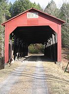
Cogan House Covered Bridge
Encyclopedia
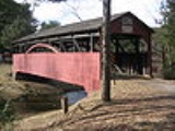
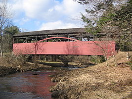
The Cogan House Covered Bridge is a Burr arch truss
covered bridge
over Larrys Creek
in Cogan House Township, Lycoming County
in the U.S. state
of Pennsylvania
. It was built in 1877 and is 94 inch long. The bridge was placed on the National Register of Historic Places
in 1980, and had a major restoration in 1998. The Cogan House bridge is named for the township
and village of Cogan House, but is also known by at least four other names: Buckhorn, Larrys Creek, Day's, and Plankenhorn.
The Cogan House Covered Bridge was constructed by a millwright
who assembled the timber framework in a field next to the sawmill
, before it was reassembled at the bridge site. It was the only bridge on Larrys Creek that survived the flood of June 1889, and one of only a handful that were left intact in the county. Although the bridge used to carry a steady flow of tannery
and sawmill traffic, the clearcutting
of the surrounding forests meant the end of those industries by the early 20th century.
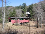
Since then much of the surrounding area has reverted to second growth forest
, and the one-lane bridge is now on a dead end road in a remote valley with little traffic. It is the oldest and longest of the three covered bridges remaining in the county. Despite the 1998 restoration and other repairs, as of 2009 the bridge structure's sufficiency rating on the National Bridge Inventory
was 14.2 percent and its condition was deemed "basically intolerable requiring high priority of corrective action".
on Campbell Road (Township Road 784), 0.1 mile (0.160934 km) past the intersection with Covered Bridge Road. Its official name on the National Register of Historic Places (NRHP) is "Cogan House Covered Bridge". It is the only covered bridge ever built in Cogan House Township and the name comes from the township, as well as the village of Cogan House, which is northeast of the bridge. Cogan House Township and the village are named for David Cogan, who settled on Larrys Creek in 1825. Cogan was one of the few settlers in the area for many years and grew tired of living nearly alone in the wilderness. In 1842 he abandoned his homestead, as did a neighbor named Carter. Their houses were used by hunters and travelers and the name Cogan's House was given to the area. Cogan House Township was formed from parts of Jackson
and Mifflin Townships
on December 6, 1843.
Since the bridge's 1998 restoration, the Lycoming County Commissioners
have officially called it the "Buckhorn Covered Bridge". The name comes from the bridge's location at the base of Buckhorn Mountain, and from the road to the former village of Buckhorn, which crossed the creek on it. This is the name used on the official plaque erected by the commissioners to mark its restoration and placement on the NRHP, despite the different name used on the Register itself. The commissioners chose "Buckhorn Covered Bridge" based on one of the names used in Benjamin and June Evans' 1993 book Pennsylvania's Covered Bridges: A Complete Guide. Historically, the commissioners used "Cogan House Covered Bridge" as the official name.
Historian Milton W. Landis uses "Larrys Creek Covered Bridge" since it crosses Larrys Creek, and notes this was the name used by other local historians. Larrys Creek is named for Larry Burt, who was the first settler at the mouth of the creek when the surveyors came through in 1769. Landis acknowledges the "Cogan House" name, and says the bridge has also been known by the names of "several tenants who lived in the little farm adjacent" to it.
While Landis does not give these different names, two other names for the bridge are known and may come from some of these tenants. The first of these is "Day's Bridge" and it is clear this is another name for the Cogan House Covered Bridge. The second of these, "Plankenhorn Bridge", is a name in a list of existing and vanished covered bridges in Lycoming County. Although the association of this name with the Cogan House Covered Bridge is not made explicitly, it is described as still standing on Larrys Creek and being north of a bridge in Mifflin Township. This is the only known covered bridge that meets those criteria.
in Philadelphia, Pennsylvania in 1800. Some of the first Burr arch truss covered bridges were also built in the state. Pennsylvania is estimated to have once had at least 1,500 covered bridges, and is believed to have had the most in the country between 1830 and 1875. In 2001 Pennsylvania had more surviving historic covered bridges than any other state, with 221 remaining in 40 of the commonwealth's 67 counties.
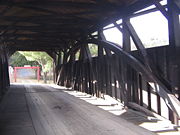
Covered bridges were a transition between stone and cast-iron and steel bridges. In 19th-century Pennsylvania, lumber was an abundant resource for bridge construction, but did not last long when exposed to weather and the elements. The roof and enclosed sides of covered bridges protected the structural elements, allowing some of these bridges to survive well over a century. A Burr arch truss consists of a load-bearing arch
sandwiching multiple King posts, resulting in a bridge which is both stronger and more rigid than one built using either element alone.
In 1850 a plank road
was built in Lycoming County, from the mouth of Larrys Creek to the borough of Salladasburg, Pennsylvania. It was later extended north along the Second Fork of Larrys Creek as far as the unincorporated villages of Brookside and White Pine in Cogan House Township, and eventually went as far as the large tannery
in the village of English Center in Pine Township
on Little Pine Creek
. Another branch of the plank road followed Larrys Creek itself north from Salladasburg. While its exact length is unknown, Landis reports it may have reached nearly to the site of the covered bridge.
Before there was a bridge, there was a ford
at the site where the bridge was later built. Wagons of finished leather and raw hides came from and went to the English Center tannery via White Pine, seeking to avoid traffic on the plank road along the Second Fork. Other traffic went to and from a large sawmill at White Pine and other mills to the west and north. Traffic from the north crossed Larrys Creek, and continued either east over Buckhorn Mountain to the Williamsport and Elmira Railroad
at the village of Cogan Station on Lycoming Creek
, or south down the road along Larrys Creek. This road led to a tannery on Larrys Creek about 1 miles (1.6 km) south of the ford, and to the plank road along the main branch of the creek. The plank road was a toll road
and connected with another railroad, the West Branch Division of the Pennsylvania Canal
, and the West Branch Susquehanna River
at the creek's mouth.
Because the ford was often impassable in winter or bad weather, or during high water, a petition from the citizens of Cogan House Township for a bridge to be built was filed in September 1876. They asked the county to build the bridge as it was beyond the resources of the township to do so. The petition was read on September 30, 1876, and three viewers were appointed to examine the site and report back on November 3. The viewers reported back in favor of building the bridge on November 25. On January 23, 1877, the county grand jury approved the report and the construction of the bridge.
 Landis is not certain if the bridge was built in 1877 or 1878, but every other source that mentions the date agrees it was 1877. Valentine ("Tine") Meyers (or Meyer), a millwright
and resident of the hamlet of Quiggleville in Lycoming Township
, built the bridge. The timbers for the bridge were cut at an "up and down", steam powered sawmill
owned by Robert Wood, a short distance north of the bridge site. The head sawyer at the mill was John Mecum. The wood used was pine, cut in nearby forests and hauled in ox carts to the mill. The largest timbers used in the bridge are up to 16 feet (4.9 m) long.
Meyers is not believed to have had much experience building bridges and set about construction in a unique manner. The timber framework was first assembled in a field next to the sawmill, with each new piece bolted into place after being cut. If a piece did not fit, more careful measurements were made and a new piece was cut and tested. The outlines of the sections for curved beams for the Burr arch were first marked with chalk on the wood, then the saw crew lifted and guided it by hand against the sawblade to cut the curve. After the framework was completed in the field, it was taken apart, loaded onto the same ox carts used to bring the logs to the mill, and taken to the bridge site. There the framework was reassembled on the bridge abutment
s. Bolts were used to hold all of the large pieces together, while cross-pieces and small braces were nailed in place.
The Cogan House Covered Bridge was added to the NRHP in 1980 and was listed on the 2009 National Bridge Inventory (NBI). According to the NBI, the covered bridge is 94 inch long, with a roadway 14 inch wide, and a maximum load of 7.2 short tons (6.5 MT). According to the NRHP, the bridge's "road surface width" is 19 inch, the load is 4 short tons (3.6 MT), and the clearance height is 10 inch. The width is only sufficient for a single lane of traffic. As of 2011, the clearance height posted on the bridge itself has been reduced to 8 inch, and the posted maximum load has been reduced to 3 short tons (2.7 MT). According to Landis, the top of the Burr arch is nearly 11 feet (3.4 m) above the floor of the bridge.
The covered bridge rests on the original stone abutments, which have since been reinforced with concrete. The bridge deck is made of crosswise planking, overlaid with runners in the western half and lengthwise planking in the eastern half. The upper part of the portals and the clapboard
siding is made of pine boards, and stops 3 foot (0.9144 m) below the roof line. Although the bridge was painted red as part of its 1998 restoration, in 1964 it was described as unpainted, and it does not seem to have been painted in 1980, as the NRHP nomination form describes how "its rough horizontal siding ... help[s] this small bridge blend into the surrounding forest". The roof was originally covered with wooden shingles. The bridge does not have parapet
s and has "no steel reinforcements".
 The Cogan House Covered Bridge was the only one on Larrys Creek to survive a major flood on June 1, 1889, which also washed out most other bridges throughout Lycoming County. A large fallen maple tree formed a dam just upstream of the bridge across Larrys Creek, which blocked debris and diverted the brunt of the floodwaters. The same flood destroyed the Larrys Creek plank road and the canal at the creek's mouth. The same storm system also caused the Johnstown Flood
, which killed over 2,200 people.
After the flood the plank road was only reconstructed as far north as Salladasburg, so for a time all the traffic from the English Center tannery went over the bridge on the way to the railroad at Cogan Station. However, the virgin timber which supplied the local tanneries and sawmills was all clear-cut within several years of the flood. Without timber, the industries that used the roads leading to the bridge closed and the local villages declined, or, in the case of Buckhorn, disappeared.
By 1900, there were still four covered bridges on Larrys Creek: going upstream they were at the hamlet of Larryville in Piatt Township
, at or near Mud Run in Mifflin Township, in Salladasburg, and in Cogan House Township. As of 2011, the Cogan House Covered Bridge is the oldest and longest of three 19th-century covered bridges remaining in Lycoming County (the others are the Buttonwood Covered Bridge
in Jackson Township
over Blockhouse Creek
, and the Lairdsville Covered Bridge
in Moreland Township
over Little Muncy Creek
).
The bridge had "needed repairs" made in 1964, and the original stone abutments were reinforced with concrete prior to 1966. It was added to the NRHP on July 24, 1980 in a Multiple Property Submission of seven Covered Bridges of Bradford, Sullivan and Lycoming Counties
, and was "painted and creosote
d" in 1981. The 1980 NRHP form and Zacher's 1994 book both list the bridge's condition as good. The Lycoming County Commissioners had the bridge "rehabilitated" in 1998, at a cost of $105,493. The general contractor for the restoration was Lycoming Supply Inc., which replaced some structural beams with treated southern pine and the "Dutch lap" or clapboard siding with white pine. The purlin
s and rafter
s were reconstructed using treated yellow pine, and support a new roof of cedar
shake shingles
. The deck and floor of the bridge were solid and required few repairs. The bridge was painted red, and a stone pillar was built with plaques marking the restoration and the bridge's inclusion on the NRHP.
 Because the bridge is listed on the NRHP, the Pennsylvania Historical and Museum Commission
had to approve the renovation. Pennsylvania Department of Transportation
(PennDOT) funds helped pay for the work done. The dedication ceremony was held on October 30, 1998, with Lycoming County Commissioner Russell Reitz and PennDOT Director of Municipal Services Thomas Lyons cutting a plank on wooden sawhorses with an old crosscut saw
as the ribbon cutting ceremony
. The other county commissioners and the local state representative and state senator were also present and spoke, as did a representative of the "Theodore Burr
Covered Bridge Society of Pennsylvania".
In August 2000 an inspection revealed that one of the timber arches of the Cogan House Covered Bridge was damaged by a vehicle which was over the weight limit crossing the bridge. A propane
delivery truck making a delivery to the private hunting cabin served by the bridge is thought to have caused the damage. Lycoming Supply Inc. won the bid to do the repair work in December, at a cost of $6,300. Before the repair the bridge remained open and was safe to use. The Evans' 2001 book describes the condition of the bridge as excellent.
Despite the restoration and repairs, the 2009 Federal Highway Administration
National Bridge Inventory
found the sufficiency rating of the bridge structure to be 17.5 percent. The inventory found the condition of the bridge deck was fair, the superstructure was poor, and the substructure was satisfactory. It further found that the bridge's foundations were "determined to be stable for calculated scour
conditions", however the railing "does not meet currently acceptable standards". Its overall condition was deemed "basically intolerable requiring high priority of corrective action"; the 2006 NBI estimated the cost to improve the bridge at $143,000.
The bridge is still used, although the public dirt road to it ends in a cul de sac on the east side. A gated private road continues to the private hunting camp and provides access to Pennsylvania State Game Lands
No. 114. The bridge has a posted speed limit of 10 miles per hour (4.5 m/s) and its average daily traffic was ten vehicles in 2008. Pennsylvania's Covered Bridges: A Complete Guide notes that despite being "located in a rather remote area, it is worth the trip to see this beautifully restored historic treasure."
 The following table is a comparison of published measurements of length, width and load recorded in five different sources using different methods, as well as the name or names cited. The NBI measures bridge length between the "backwalls of abutments" or pavement grooves and the roadway width as "the most restrictive minimum distance between curbs or rails". The NRHP form was prepared by the Pennsylvania Historical and Museum Commission
(PHMC), which surveyed county engineers, historical and covered bridge societies, and others for all the covered bridges in the commonwealth. The Evans visited every covered bridge in Pennsylvania in 2001 and measured each bridge's length (portal to portal) and width (at the portal) for their book. The data in Zacher's book was based on a 1991 survey of all covered bridges in Pennsylvania by the PHMC and the Pennsylvania Department of Transportation, aided by local government and private agencies. The article uses primarily the NBI and NRHP data, as they are national programs.
Burr Truss
The Burr Arch Truss — or simply Burr Truss or Burr Arch — is a combination of an arch and a multiple kingpost truss design. It was invented in 1804 by Theodore Burr, patented on April 3, 1817, and used in bridges, usually covered bridges....
covered bridge
Covered bridge
A covered bridge is a bridge with enclosed sides and a roof, often accommodating only a single lane of traffic. Most covered bridges are wooden; some newer ones are concrete or metal with glass sides...
over Larrys Creek
Larrys Creek
Larrys Creek is a tributary of the West Branch Susquehanna River in Lycoming County in the U.S. state of Pennsylvania. A part of the Chesapeake Bay drainage basin, its watershed drains in six townships and a borough...
in Cogan House Township, Lycoming County
Lycoming County, Pennsylvania
-Appalachian Mountains and Allegheny Plateau:Lycoming County is divided between the Appalachian Mountains in the south, the dissected Allegheny Plateau in the north and east, and the valley of the West Branch Susquehanna River between these.-West Branch Susquehanna River:The West Branch of the...
in the U.S. state
U.S. state
A U.S. state is any one of the 50 federated states of the United States of America that share sovereignty with the federal government. Because of this shared sovereignty, an American is a citizen both of the federal entity and of his or her state of domicile. Four states use the official title of...
of Pennsylvania
Pennsylvania
The Commonwealth of Pennsylvania is a U.S. state that is located in the Northeastern and Mid-Atlantic regions of the United States. The state borders Delaware and Maryland to the south, West Virginia to the southwest, Ohio to the west, New York and Ontario, Canada, to the north, and New Jersey to...
. It was built in 1877 and is 94 inch long. The bridge was placed on the National Register of Historic Places
National Register of Historic Places
The National Register of Historic Places is the United States government's official list of districts, sites, buildings, structures, and objects deemed worthy of preservation...
in 1980, and had a major restoration in 1998. The Cogan House bridge is named for the township
Township (Pennsylvania)
A township in the Commonwealth of Pennsylvania, a state of the United States of America, is one of four types of municipalities in the state . Townships were established based on convenient geographical boundaries and vary in size from six to forty square miles...
and village of Cogan House, but is also known by at least four other names: Buckhorn, Larrys Creek, Day's, and Plankenhorn.
The Cogan House Covered Bridge was constructed by a millwright
Millwright
A millwright is a craftsman or tradesman engaged with the construction and maintenance of machinery.Early millwrights were specialist carpenters who erected machines used in agriculture, food processing and processing lumber and paper...
who assembled the timber framework in a field next to the sawmill
Sawmill
A sawmill is a facility where logs are cut into boards.-Sawmill process:A sawmill's basic operation is much like those of hundreds of years ago; a log enters on one end and dimensional lumber exits on the other end....
, before it was reassembled at the bridge site. It was the only bridge on Larrys Creek that survived the flood of June 1889, and one of only a handful that were left intact in the county. Although the bridge used to carry a steady flow of tannery
Tanning
Tanning is the making of leather from the skins of animals which does not easily decompose. Traditionally, tanning used tannin, an acidic chemical compound from which the tanning process draws its name . Coloring may occur during tanning...
and sawmill traffic, the clearcutting
Clearcutting
Clearcutting, or clearfelling, is a controversial forestry/logging practice in which most or all trees in an area are uniformly cut down. Clearcutting, along with shelterwood and seed tree harvests, is used by foresters to create certain types of forest ecosystems and to promote select species that...
of the surrounding forests meant the end of those industries by the early 20th century.
Since then much of the surrounding area has reverted to second growth forest
Secondary forest
A secondary forest is a forest or woodland area which has re-grown after a major disturbance such as fire, insect infestation, timber harvest or windthrow, until a long enough period has passed so that the effects of the disturbance are no longer evident...
, and the one-lane bridge is now on a dead end road in a remote valley with little traffic. It is the oldest and longest of the three covered bridges remaining in the county. Despite the 1998 restoration and other repairs, as of 2009 the bridge structure's sufficiency rating on the National Bridge Inventory
National Bridge Inventory
The National Bridge Inventory is a database, compiled by the Federal Highway Administration, with information on all bridges and tunnels in the United States that have roads passing above or below. This is similar to the grade crossing identifier number database compiled by the Federal Railroad...
was 14.2 percent and its condition was deemed "basically intolerable requiring high priority of corrective action".
Names
The covered bridge is 1.4 miles (2.3 km) south of Pennsylvania Route 184Pennsylvania Route 184
Pennsylvania Route 184 is an long state highway located in Lycoming county in Pennsylvania. The western terminus is at Route 287 in Brookside. The eastern terminus is at Steam Mill Road, just after an interchange with U.S. Route 15 in Steam Valley, a hamlet of Cogan House Township...
on Campbell Road (Township Road 784), 0.1 mile (0.160934 km) past the intersection with Covered Bridge Road. Its official name on the National Register of Historic Places (NRHP) is "Cogan House Covered Bridge". It is the only covered bridge ever built in Cogan House Township and the name comes from the township, as well as the village of Cogan House, which is northeast of the bridge. Cogan House Township and the village are named for David Cogan, who settled on Larrys Creek in 1825. Cogan was one of the few settlers in the area for many years and grew tired of living nearly alone in the wilderness. In 1842 he abandoned his homestead, as did a neighbor named Carter. Their houses were used by hunters and travelers and the name Cogan's House was given to the area. Cogan House Township was formed from parts of Jackson
Jackson Township, Lycoming County, Pennsylvania
Jackson Township is a township located in northern Lycoming County, Pennsylvania in the United States. The population was 414 at the 2000 census. It is part of the Williamsport, Pennsylvania Metropolitan Statistical Area....
and Mifflin Townships
Mifflin Township, Lycoming County, Pennsylvania
Mifflin Township is a township in Lycoming County, Pennsylvania, in the United States. The population was 1,145 at the 2000 census. It is part of the Williamsport, Pennsylvania Metropolitan Statistical Area.- History :...
on December 6, 1843.
Since the bridge's 1998 restoration, the Lycoming County Commissioners
County commission
A county commission is a group of elected officials charged with administering the county government in local government in some states of the United States. County commissions are usually made up of three or more individuals...
have officially called it the "Buckhorn Covered Bridge". The name comes from the bridge's location at the base of Buckhorn Mountain, and from the road to the former village of Buckhorn, which crossed the creek on it. This is the name used on the official plaque erected by the commissioners to mark its restoration and placement on the NRHP, despite the different name used on the Register itself. The commissioners chose "Buckhorn Covered Bridge" based on one of the names used in Benjamin and June Evans' 1993 book Pennsylvania's Covered Bridges: A Complete Guide. Historically, the commissioners used "Cogan House Covered Bridge" as the official name.
Historian Milton W. Landis uses "Larrys Creek Covered Bridge" since it crosses Larrys Creek, and notes this was the name used by other local historians. Larrys Creek is named for Larry Burt, who was the first settler at the mouth of the creek when the surveyors came through in 1769. Landis acknowledges the "Cogan House" name, and says the bridge has also been known by the names of "several tenants who lived in the little farm adjacent" to it.
While Landis does not give these different names, two other names for the bridge are known and may come from some of these tenants. The first of these is "Day's Bridge" and it is clear this is another name for the Cogan House Covered Bridge. The second of these, "Plankenhorn Bridge", is a name in a list of existing and vanished covered bridges in Lycoming County. Although the association of this name with the Cogan House Covered Bridge is not made explicitly, it is described as still standing on Larrys Creek and being north of a bridge in Mifflin Township. This is the only known covered bridge that meets those criteria.
History
| Map of the covered bridge's location on Larrys Creek |
Background
The first covered bridge in the United States was built over the Schuylkill RiverSchuylkill River
The Schuylkill River is a river in Pennsylvania. It is a designated Pennsylvania Scenic River.The river is about long. Its watershed of about lies entirely within the state of Pennsylvania. The source of its eastern branch is in the Appalachian Mountains at Tuscarora Springs, near Tamaqua in...
in Philadelphia, Pennsylvania in 1800. Some of the first Burr arch truss covered bridges were also built in the state. Pennsylvania is estimated to have once had at least 1,500 covered bridges, and is believed to have had the most in the country between 1830 and 1875. In 2001 Pennsylvania had more surviving historic covered bridges than any other state, with 221 remaining in 40 of the commonwealth's 67 counties.
Covered bridges were a transition between stone and cast-iron and steel bridges. In 19th-century Pennsylvania, lumber was an abundant resource for bridge construction, but did not last long when exposed to weather and the elements. The roof and enclosed sides of covered bridges protected the structural elements, allowing some of these bridges to survive well over a century. A Burr arch truss consists of a load-bearing arch
Arch
An arch is a structure that spans a space and supports a load. Arches appeared as early as the 2nd millennium BC in Mesopotamian brick architecture and their systematic use started with the Ancient Romans who were the first to apply the technique to a wide range of structures.-Technical aspects:The...
sandwiching multiple King posts, resulting in a bridge which is both stronger and more rigid than one built using either element alone.
In 1850 a plank road
Plank road
A plank road or puncheon is a dirt path or road covered with a series of planks, similar to the wooden sidewalks one would see in a Western movie. Plank roads were very popular in Ontario, the U.S. Northeast and U.S. Midwest in the first half of the 19th century...
was built in Lycoming County, from the mouth of Larrys Creek to the borough of Salladasburg, Pennsylvania. It was later extended north along the Second Fork of Larrys Creek as far as the unincorporated villages of Brookside and White Pine in Cogan House Township, and eventually went as far as the large tannery
Tanning
Tanning is the making of leather from the skins of animals which does not easily decompose. Traditionally, tanning used tannin, an acidic chemical compound from which the tanning process draws its name . Coloring may occur during tanning...
in the village of English Center in Pine Township
Pine Township, Lycoming County, Pennsylvania
Pine Township is a township in Lycoming County, Pennsylvania, in the United States. The population was 329 at the 2000 census. It is part of the Williamsport, Pennsylvania Metropolitan Statistical Area.-History:...
on Little Pine Creek
Little Pine Creek
Little Pine Creek is a tributary of Pine Creek in Lycoming County, Pennsylvania in the United States.Little Pine Creek is formed by the confluence of Blockhouse Creek and Texas Creek, approximately upstream of Pine Creek. Blacks Creek joins Blockhouse Creek approximately above. of Little Pine...
. Another branch of the plank road followed Larrys Creek itself north from Salladasburg. While its exact length is unknown, Landis reports it may have reached nearly to the site of the covered bridge.
Before there was a bridge, there was a ford
Ford (crossing)
A ford is a shallow place with good footing where a river or stream may be crossed by wading or in a vehicle. A ford is mostly a natural phenomenon, in contrast to a low water crossing, which is an artificial bridge that allows crossing a river or stream when water is low.The names of many towns...
at the site where the bridge was later built. Wagons of finished leather and raw hides came from and went to the English Center tannery via White Pine, seeking to avoid traffic on the plank road along the Second Fork. Other traffic went to and from a large sawmill at White Pine and other mills to the west and north. Traffic from the north crossed Larrys Creek, and continued either east over Buckhorn Mountain to the Williamsport and Elmira Railroad
Williamsport and Elmira Railroad
The Elmira and Williamsport Railroad is a historic railroad that operated in Pennsylvania.The W&E was organized in 1832 and ran between Williamsport, Pennsylvania and Elmira, New York...
at the village of Cogan Station on Lycoming Creek
Lycoming Creek
Lycoming Creek is a tributary of the West Branch Susquehanna River located in Tioga and Lycoming counties in Pennsylvania in the United States.-Geography:...
, or south down the road along Larrys Creek. This road led to a tannery on Larrys Creek about 1 miles (1.6 km) south of the ford, and to the plank road along the main branch of the creek. The plank road was a toll road
Toll road
A toll road is a privately or publicly built road for which a driver pays a toll for use. Structures for which tolls are charged include toll bridges and toll tunnels. Non-toll roads are financed using other sources of revenue, most typically fuel tax or general tax funds...
and connected with another railroad, the West Branch Division of the Pennsylvania Canal
Pennsylvania Canal (West Branch Division)
The West Branch Division of the Pennsylvania Canal ran from the canal basin at Northumberland, Pennsylvania, at the confluence of the West Branch Susquehanna River with the main stem of the Susquehanna River, north through Muncy, then west through Williamsport, Jersey Shore, and Lock Haven to its...
, and the West Branch Susquehanna River
West Branch Susquehanna River
The West Branch Susquehanna River is one of the two principal branches, along with the North Branch, of the Susquehanna River in the northeastern United States. The North Branch, which rises in upstate New York, is generally regarded as the extension of the main branch, with the shorter West Branch...
at the creek's mouth.
Because the ford was often impassable in winter or bad weather, or during high water, a petition from the citizens of Cogan House Township for a bridge to be built was filed in September 1876. They asked the county to build the bridge as it was beyond the resources of the township to do so. The petition was read on September 30, 1876, and three viewers were appointed to examine the site and report back on November 3. The viewers reported back in favor of building the bridge on November 25. On January 23, 1877, the county grand jury approved the report and the construction of the bridge.
Construction and description
Millwright
A millwright is a craftsman or tradesman engaged with the construction and maintenance of machinery.Early millwrights were specialist carpenters who erected machines used in agriculture, food processing and processing lumber and paper...
and resident of the hamlet of Quiggleville in Lycoming Township
Lycoming Township, Pennsylvania
Lycoming Township is a township in Lycoming County, Pennsylvania, in the United States. The population was 1,606 at the 2000 census. It is part of the Williamsport, Pennsylvania Metropolitan Statistical Area.-History:...
, built the bridge. The timbers for the bridge were cut at an "up and down", steam powered sawmill
Sawmill
A sawmill is a facility where logs are cut into boards.-Sawmill process:A sawmill's basic operation is much like those of hundreds of years ago; a log enters on one end and dimensional lumber exits on the other end....
owned by Robert Wood, a short distance north of the bridge site. The head sawyer at the mill was John Mecum. The wood used was pine, cut in nearby forests and hauled in ox carts to the mill. The largest timbers used in the bridge are up to 16 feet (4.9 m) long.
Meyers is not believed to have had much experience building bridges and set about construction in a unique manner. The timber framework was first assembled in a field next to the sawmill, with each new piece bolted into place after being cut. If a piece did not fit, more careful measurements were made and a new piece was cut and tested. The outlines of the sections for curved beams for the Burr arch were first marked with chalk on the wood, then the saw crew lifted and guided it by hand against the sawblade to cut the curve. After the framework was completed in the field, it was taken apart, loaded onto the same ox carts used to bring the logs to the mill, and taken to the bridge site. There the framework was reassembled on the bridge abutment
Abutment
An abutment is, generally, the point where two structures or objects meet. This word comes from the verb abut, which means adjoin or having common boundary. An abutment is an engineering term that describes a structure located at the ends of a bridge, where the bridge slab adjoins the approaching...
s. Bolts were used to hold all of the large pieces together, while cross-pieces and small braces were nailed in place.
The Cogan House Covered Bridge was added to the NRHP in 1980 and was listed on the 2009 National Bridge Inventory (NBI). According to the NBI, the covered bridge is 94 inch long, with a roadway 14 inch wide, and a maximum load of 7.2 short tons (6.5 MT). According to the NRHP, the bridge's "road surface width" is 19 inch, the load is 4 short tons (3.6 MT), and the clearance height is 10 inch. The width is only sufficient for a single lane of traffic. As of 2011, the clearance height posted on the bridge itself has been reduced to 8 inch, and the posted maximum load has been reduced to 3 short tons (2.7 MT). According to Landis, the top of the Burr arch is nearly 11 feet (3.4 m) above the floor of the bridge.
The covered bridge rests on the original stone abutments, which have since been reinforced with concrete. The bridge deck is made of crosswise planking, overlaid with runners in the western half and lengthwise planking in the eastern half. The upper part of the portals and the clapboard
Clapboard (architecture)
Clapboard, also known as bevel siding or lap siding or weather-board , is a board used typically for exterior horizontal siding that has one edge thicker than the other and where the board above laps over the one below...
siding is made of pine boards, and stops 3 foot (0.9144 m) below the roof line. Although the bridge was painted red as part of its 1998 restoration, in 1964 it was described as unpainted, and it does not seem to have been painted in 1980, as the NRHP nomination form describes how "its rough horizontal siding ... help[s] this small bridge blend into the surrounding forest". The roof was originally covered with wooden shingles. The bridge does not have parapet
Parapet
A parapet is a wall-like barrier at the edge of a roof, terrace, balcony or other structure. Where extending above a roof, it may simply be the portion of an exterior wall that continues above the line of the roof surface, or may be a continuation of a vertical feature beneath the roof such as a...
s and has "no steel reinforcements".
Use and restoration
Johnstown Flood
The Johnstown Flood occurred on May 31, 1889. It was the result of the catastrophic failure of the South Fork Dam situated upstream of the town of Johnstown, Pennsylvania, USA, made worse by several days of extremely heavy rainfall...
, which killed over 2,200 people.
After the flood the plank road was only reconstructed as far north as Salladasburg, so for a time all the traffic from the English Center tannery went over the bridge on the way to the railroad at Cogan Station. However, the virgin timber which supplied the local tanneries and sawmills was all clear-cut within several years of the flood. Without timber, the industries that used the roads leading to the bridge closed and the local villages declined, or, in the case of Buckhorn, disappeared.
By 1900, there were still four covered bridges on Larrys Creek: going upstream they were at the hamlet of Larryville in Piatt Township
Piatt Township, Pennsylvania
Piatt Township is a township in Lycoming County, Pennsylvania, in the United States. The population was 1,259 at the 2000 census. It is part of the Williamsport, Pennsylvania Metropolitan Statistical Area.-History:...
, at or near Mud Run in Mifflin Township, in Salladasburg, and in Cogan House Township. As of 2011, the Cogan House Covered Bridge is the oldest and longest of three 19th-century covered bridges remaining in Lycoming County (the others are the Buttonwood Covered Bridge
Buttonwood Covered Bridge
The Buttonwood Covered Bridge is a covered bridge built in either 1878 or 1898 over Blockhouse Creek in Jackson Township, Lycoming County in the U.S. state of Pennsylvania. It uses a queen post with king post truss and is long. The bridge was placed on the National Register of Historic Places in...
in Jackson Township
Jackson Township, Lycoming County, Pennsylvania
Jackson Township is a township located in northern Lycoming County, Pennsylvania in the United States. The population was 414 at the 2000 census. It is part of the Williamsport, Pennsylvania Metropolitan Statistical Area....
over Blockhouse Creek
Little Pine Creek
Little Pine Creek is a tributary of Pine Creek in Lycoming County, Pennsylvania in the United States.Little Pine Creek is formed by the confluence of Blockhouse Creek and Texas Creek, approximately upstream of Pine Creek. Blacks Creek joins Blockhouse Creek approximately above. of Little Pine...
, and the Lairdsville Covered Bridge
Lairdsville Covered Bridge
The Lairdsville Covered Bridge is a wooden covered bridge over Little Muncy Creek in Moreland Township, Lycoming County, Pennsylvania in the U.S. state of Pennsylvania. It was built in 1888 and placed on the National Register of Historic Places in 1980....
in Moreland Township
Moreland Township, Pennsylvania
Moreland Township is a township in Lycoming County, Pennsylvania, in the United States. The population was 1,036 at the 2000 census. It is part of the Williamsport, Pennsylvania, Metropolitan Statistical Area.-History:...
over Little Muncy Creek
Little Muncy Creek
Little Muncy Creek is the major tributary of Muncy Creek in Lycoming and Sullivan Counties, Pennsylvania, USA. Via Muncy Creek and the West Branch Susquehanna River, it is part of the Susquehanna River drainage basin and waters from it flow ultimately into the Chesapeake Bay.-Course:Little Muncy...
).
The bridge had "needed repairs" made in 1964, and the original stone abutments were reinforced with concrete prior to 1966. It was added to the NRHP on July 24, 1980 in a Multiple Property Submission of seven Covered Bridges of Bradford, Sullivan and Lycoming Counties
Covered Bridges of Bradford, Sullivan and Lycoming Counties
The Covered Bridges of Bradford, Sullivan and Lycoming Counties are seven covered bridges in northcentral Pennsylvania in the United States, which were included on the National Register of Historic Places in a Thematic Resources submission on July 24, 1980. One of the bridges is in Bradford...
, and was "painted and creosote
Creosote
Creosote is the portion of chemical products obtained by the distillation of a tar that remains heavier than water, notably useful for its anti-septic and preservative properties...
d" in 1981. The 1980 NRHP form and Zacher's 1994 book both list the bridge's condition as good. The Lycoming County Commissioners had the bridge "rehabilitated" in 1998, at a cost of $105,493. The general contractor for the restoration was Lycoming Supply Inc., which replaced some structural beams with treated southern pine and the "Dutch lap" or clapboard siding with white pine. The purlin
Purlin
In architecture or structural engineering or building, a purlin is a horizontal structural member in a roof. Purlins support the loads from the roof deck or sheathing and are supported by the principal rafters and/or the building walls, steel beams etc...
s and rafter
Rafter
A rafter is one of a series of sloped structural members , that extend from the ridge or hip to the downslope perimeter or eave, designed to support the roof deck and its associated loads.-Design:...
s were reconstructed using treated yellow pine, and support a new roof of cedar
Cedar wood
Cedar wood comes from several different trees that grow in different parts of the world, and may have different uses.* California incense-cedar, from Calocedrus decurrens, is the primary type of wood used for making pencils...
shake shingles
Shake (shingle)
A shake is a basic wooden shingle that is made from split logs. Shakes have traditionally been used for roofing and siding applications around the world. Higher grade shakes are typically used for roofing purposes, while the lower grades are used for siding purposes...
. The deck and floor of the bridge were solid and required few repairs. The bridge was painted red, and a stone pillar was built with plaques marking the restoration and the bridge's inclusion on the NRHP.
Pennsylvania Historical and Museum Commission
The Pennsylvania Historical and Museum Commission is the governmental agency of the Commonwealth of Pennsylvania responsible for the collection, conservation and interpretation of Pennsylvania's historic heritage...
had to approve the renovation. Pennsylvania Department of Transportation
Pennsylvania Department of Transportation
The Pennsylvania Department of Transportation oversees transportation issues in the Commonwealth of Pennsylvania. The administrator of PennDOT is the Pennsylvania Secretary of Transportation, currently Barry Schoch Presently, PennDOT supports over of state roads and highways, about 25,000...
(PennDOT) funds helped pay for the work done. The dedication ceremony was held on October 30, 1998, with Lycoming County Commissioner Russell Reitz and PennDOT Director of Municipal Services Thomas Lyons cutting a plank on wooden sawhorses with an old crosscut saw
Crosscut saw
A crosscut saw is a saw that is specially designed for making crosscuts. A crosscut is a cut made horizontally through the trunk of a standing tree, but the term also applies to cutting free lumber...
as the ribbon cutting ceremony
Ribbon cutting ceremony
]A ribbon cutting ceremony is a public ceremony conducted to inaugurate the opening to the general public of a new building or business.Often, the ceremony is conducted in just the manner the name suggests: by tying a ceremonial ribbon across the main entrance of the building, which is then cut in...
. The other county commissioners and the local state representative and state senator were also present and spoke, as did a representative of the "Theodore Burr
Theodore Burr
Theodore Burr was an inventor from Torringford, Connecticut, who was credited with the Burr Arch Truss bridge design and was cousin of vice president Aaron Burr. Theodore Burr came to Oxford, New York in 1792. By 1794, he had built a grist mill , and a dam to power the mill...
Covered Bridge Society of Pennsylvania".
In August 2000 an inspection revealed that one of the timber arches of the Cogan House Covered Bridge was damaged by a vehicle which was over the weight limit crossing the bridge. A propane
Propane
Propane is a three-carbon alkane with the molecular formula , normally a gas, but compressible to a transportable liquid. A by-product of natural gas processing and petroleum refining, it is commonly used as a fuel for engines, oxy-gas torches, barbecues, portable stoves, and residential central...
delivery truck making a delivery to the private hunting cabin served by the bridge is thought to have caused the damage. Lycoming Supply Inc. won the bid to do the repair work in December, at a cost of $6,300. Before the repair the bridge remained open and was safe to use. The Evans' 2001 book describes the condition of the bridge as excellent.
Despite the restoration and repairs, the 2009 Federal Highway Administration
Federal Highway Administration
The Federal Highway Administration is a division of the United States Department of Transportation that specializes in highway transportation. The agency's major activities are grouped into two "programs," the Federal-aid Highway Program and the Federal Lands Highway Program...
National Bridge Inventory
National Bridge Inventory
The National Bridge Inventory is a database, compiled by the Federal Highway Administration, with information on all bridges and tunnels in the United States that have roads passing above or below. This is similar to the grade crossing identifier number database compiled by the Federal Railroad...
found the sufficiency rating of the bridge structure to be 17.5 percent. The inventory found the condition of the bridge deck was fair, the superstructure was poor, and the substructure was satisfactory. It further found that the bridge's foundations were "determined to be stable for calculated scour
Bridge scour
Bridge scour is the removal of sediment such as sand and rocks from around bridge abutments or piers. Scour, caused by swiftly moving water, can scoop out scour holes, compromising the integrity of a structure....
conditions", however the railing "does not meet currently acceptable standards". Its overall condition was deemed "basically intolerable requiring high priority of corrective action"; the 2006 NBI estimated the cost to improve the bridge at $143,000.
The bridge is still used, although the public dirt road to it ends in a cul de sac on the east side. A gated private road continues to the private hunting camp and provides access to Pennsylvania State Game Lands
Pennsylvania State Game Lands
The Pennsylvania State Game Lands are lands managed by the Pennsylvania Game Commission for hunting, trapping, and fishing. These lands, often not usable for farming or development, are donated to the PGC or purchased by the PGC with hunting license monies.The Pennsylvania Game Commission runs a...
No. 114. The bridge has a posted speed limit of 10 miles per hour (4.5 m/s) and its average daily traffic was ten vehicles in 2008. Pennsylvania's Covered Bridges: A Complete Guide notes that despite being "located in a rather remote area, it is worth the trip to see this beautifully restored historic treasure."
Bridge data
Pennsylvania Historical and Museum Commission
The Pennsylvania Historical and Museum Commission is the governmental agency of the Commonwealth of Pennsylvania responsible for the collection, conservation and interpretation of Pennsylvania's historic heritage...
(PHMC), which surveyed county engineers, historical and covered bridge societies, and others for all the covered bridges in the commonwealth. The Evans visited every covered bridge in Pennsylvania in 2001 and measured each bridge's length (portal to portal) and width (at the portal) for their book. The data in Zacher's book was based on a 1991 survey of all covered bridges in Pennsylvania by the PHMC and the Pennsylvania Department of Transportation, aided by local government and private agencies. The article uses primarily the NBI and NRHP data, as they are national programs.
| Length feet (m) |
Width feet (m) |
Load short tons (MT) |
Name(s) used |
Source (Year) |
|---|---|---|---|---|
| 95 feet (29 m) | 17 inch | 3 short tons (2.7 MT) | Larrys Creek, Cogan House | Landis (1966, 1981) |
| 94 inch | 14 inch | 7.2 short tons (6.5 MT) | Cogan House | NBI (2009) |
| 93 feet (28.3 m) | 19 inch | 4 short tons (3.6 MT) | Cogan House | NRHP (1980) |
| 91 inch | 17 inch | NA | Cogan House, Buckhorn | Evans (2001) |
| 81 feet (24.7 m) | 19 inch | NA | Cogan House | Zacher (1994) |
See also
- List of bridges on the National Register of Historic Places in Pennsylvania
- List of tributaries of Larrys Creek