

U.S. Route 220
Encyclopedia
U.S. Route 220 is a 680 miles (1,094 km) long U.S. Route in the eastern United States
.
US 220 is a spur route of U.S. Route 20
but at present, the two routes do not intersect nor do they connect via other spurs of US 20. The former U. S. Route 120, which was signed in Pennsylvania between 1926 and 1967, intersected U.S. Route 220 at Lock Haven, Pennsylvania. Also, the 1926 routing of U.S. Route 220 along PA Route 4 north from Williamsport as far as the New York State line ended at that spot only because in the 1920s, New York State's policy was not to sign any three-digit U. S. Route numbers on its roads; U. S. Routes 106 and 219 also ended abruptly at the Pennsylvania-New York border. If the U.S. Route 220 signing had continued north along what in 1925 was designated NY Route 4, and after the adoption of U. S. Route signing in New York NY Route 2, U.S. Route 220 would indeed have intersected U. S. Route 20 in central New York.
The southern terminus of US 220 is at U.S. Route 1
in Rockingham, North Carolina
. The northern terminus is at Chemung Street in Waverly, New York
, just north of its interchange with New York State Route 17
and (future) Interstate 86
. Some sections are part of the Appalachian Development Highway System
's Corridor O as well as Interstate 73
in North Carolina
.
In early 1927, US 220 absorbed most of U.S. Route 711, which had run from Northumberland, Pennsylvania
north to the New York
state line. The portion south of Muncy was already part of U.S. Route 120. Former US 220 north to the state line at Lawrenceville became part of an extension of U.S. Route 111
.
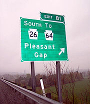
in Rockingham
, North Carolina
. From Rockingham, US 220 travels north through Richmond
, Montgomery
, and Randolph Counties
. South of the town of Ellerbe
, US 220 follows a newly constructed four-lane bypass freeway, sharing Future Interstate 74
and Future Interstate 73
. The old US 220 route is signed as Business/Alternate 220, which passes through the towns of Ellerbe
, Norman
, Candor
, Biscoe
, Star
, and Seagrove
. Rejoining US 220 near the North Carolina Zoo
, ALT 220 continues into Asheboro
and Randleman
as Business 220 while US 220 Bypass continues north to Level Cross. There, the Business and Bypass routes merge and travel north into Guilford County
. Outside Greensboro
, US 220 intersects Interstate 85
and U.S. Route 421
(Greensboro Urban Loop
) before intersecting Business 85
and eventually merging with Interstate 40
in the city. US 220 then exits with U.S. Highway 29 and U.S. Highway 70 onto O'Henry Boulevard and then continues west on Wendover Avenue, just north of Greensboro's Downtown. Exiting onto Battleground Avenue, US 220 travels north out of Greensboro and into Summerfield, North Carolina
before entering Rockingham County
. Business 220 splits to go through Madison
and Mayodan
and returns to US 220 near Stoneville
. US 220 crosses the Virginia
border near the town of Ridgeway, Virginia
.
. It uses freeway spurs to bypass Martinsville
and Rocky Mount
. The remainder of U.S. 220 is a divided four lane highway with a 55 mile per hour speed limit for most of the distance between Martinsville
and State Route 419 in Roanoke County
. Some high traffic areas and non-divided stretches have 45 mile per hour, or lower, speed limits. In particular, the stretch through Boones Mill, Virginia
is not divided; the town is also well known as a speed trap
. U.S. 220 is a winding road in several stretches, and there have been many accidents. The proposed Interstate 73
would generally parallel U.S. 220 between Roanoke
and Greensboro, North Carolina
, though funds have not been allocated for the project and some local residents prefer efforts to fix U.S. 220. At Virginia 419, U.S. 220 becomes a freeway, the Roy L. Webber Expressway, once again. At downtown Roanoke
, it becomes co-signed with Interstate 581
until the freeway reaches Interstate 81
north of Roanoke.
U.S. 220 continues along Interstate 81
northbound until it resumes near Daleville
, at the interchange with Alternate U.S. 220. It once again becomes a four-lane road until just outside of Clifton Forge
, and joins up with Interstate 64
westbound until Covington
. It then continues a primarily two-lane mountainous path until exiting Virginia
.
U.S. Route 311
was designated in 1926 to run from U.S. Route 11 in Roanoke south along State Route 33 to North Carolina
. US 220, another 1926 U.S. Highway, was extended south into Virginia by 1935. It replaced the piece of State Route 18 north of Covington, all of State Route 12(Clifton Forge to near Roanoke), and all of US 311 in Virginia.
2 miles (3 km) south of Harper in Pendleton County
. From the state line, US 220 parallels the South Branch Potomac River as it progresses northward. 13 miles (21 km) north of Harper, US 220 passes through Franklin
, where it intersects with U.S. Route 33
. The route crosses into Grant County
approximately 17 miles (27.4 km) north of Franklin.
Within Grant County, US 220 intersects the concurrent routes of West Virginia Route 28/West Virginia Route 55 in Petersburg
. The two state highways join US 220 eastward into Hardy County
. WV 28 and WV 55 remain concurrent to Moorefield
, where WV 55 splits from US 220 and WV 28. North of Moorefield, US 220/WV 28 intersects the future right-of-way of U.S. Route 48
. US 220 and WV 28 remain concurrent into Hampshire County
, where US 220 and WV 28 meet U.S. Route 50
in Junction
. WV 28 departs US 220, following US 50 to the east, while US 220 joins US 50 westward into Mineral County
.
At the top of Knobly Mountain
northwest of Ridgeville
, US 220 splits from US 50 and resumes a northerly alignment as it descends into the New Creek Valley
. 7 miles (11 km) north of US 50, US 220 enters Keyser
, the county seat of Mineral County. In the center of the city, US 220 intersects West Virginia Route 46. At the northern edge of Keyser, US 220 crosses the North Branch Potomac River via Memorial Bridge, leaving West Virginia and entering Maryland
.
, Allegany County
. In McCoole, US 220 intersects the eastern terminus of Maryland Route 135
. Past MD 135, US 220 turns to the northeast, paralleling the North Branch of the Potomac River
to the east. 12 miles (19 km) into Maryland, with West Virginia
visible to the right, US 220 intersects the western terminus of Maryland Route 956
, a connector to a secondary state highway in West Virginia. Continuing north in the river valley, US 220 enters Cresaptown
, where US 220 intersects with the east end of Maryland Route 53
. 4 miles (6 km) north of Cresaptown, US 220 joins with Interstate 68
and U.S. Route 40
in Cumberland
. At exit 46, US 220 turns north again, separating from I-68 and US 40 for a few miles before crossing the Mason-Dixon Line
into Pennsylvania
. North of I-68, US 220 is designate by the Appalachian Development Highway System
as Corridor O until US 220 reaches Interstate 80
near Bellefonte, Pennsylvania
.
 After crossing the state line from Maryland, US 220 runs north through Bedford County
to Bedford
, where it divides into U.S. Route 220 Business, which enters the town of Bedford, and the main branch, which joins the southern terminus of Interstate 99
at an interchange with the Pennsylvania Turnpike
.
The US 220/I-99 duplex continues northeast along the west side of Dunning Mountain and then Brush Mountain into Blair County
and passes the towns of Altoona
and Tyrone
.
Just north of Port Matilda
in Centre County
, US 220 was recently rerouted to go through State College
to follow the alignment of the I-99. US 322 joins the alignment to form a triplex. US 220 previously continued northeast of Port Matilda to an interchange with Interstate 80 near Milesburg
. This previous route was redesignated as Alternate US 220, which meets back up with US 220 along its own duplex with I-80 near Bellefonte
. This portion of US 220, from Interstate 68
in Maryland
north to Bellefonte
, is designated by the Appalachian Development Highway System
as Corridor O.
From Port Matilda, US 220, I-99, and US 322 continue eastward 12 miles (19 km) to just north of State College
where US 322 diverges eastward while US 220 and I-99 continue northward. The duplex travels past Bellefonte
then joins I-80 eastward, where Interstate 99 currently ends.
US 220 follows I-80 eastward for 11 miles (18 km), then exits northward to travel through Lock Haven
. Near Lock Haven, US 220 alternates between an at-grade road and a limited-access expressway several times, and joins Interstate 180
at Williamsport
, traveling eastbound. East of Williamsport, I-180 turns to the south and US 220 exits the expressway onto a two-lane road that first travels east to Hughesville
, where is turns northeast at an intersection with PA 405
. A short section of super-two limited-access freeway is used to bypass Towanda
, including an interchange with US 6
. US 220 then continues on a northerly path to the New York
state line at South Waverly
.
In the future, US 220 and Interstate 99 two will form a duplex for 135 miles (217 km) throughout much of central Pennsylvania, from the interchange with the Pennsylvania Turnpike at Bedford to the intersection with US 15 at Williamsport, where US 220 will continue on its existing alignment and Interstate 99 will depart north onto US 15.
 US 220 enters New York
at Waverly
. US 220 continues north for less than a tenth of a mile to its northern terminus at Chemung Street, formerly NY 17 prior to construction of the Southern Tier Expressway. The nearest New York State touring routes from US 220's terminus are NY 17C
, NY 17 as noted, and NY 34
. Both NY 17C and NY 34 are reached via a right turn at Chemung Street.
28 March 2006 109th CONGRESS, 2d Session, H. R. 5031, To extend Corridor O of the Appalachian Development Highway System from its current southern terminus at I-68 near Cumberland to Corridor H, which stretches from Weston, West Virginia, to Strasburg, Virginia.
A new highway was proposed in 2006, to extend Appalachian Corridor O, which now runs through Pennsylvania, through Maryland and West Virginia and connect with Corridor H (which will run from Weston, WV to Wardensville, WV and possibly connect with Interstate 81 in Virginia when completed). Committees have been formed and met in the three major cities along the route: Keyser, Cumberland, and Moorefield. Several different proposals have been discussed including one which will follow Interstate 68 west through Cumberland and then go south toward Keyser, WV, becoming the new US 220 replacing McMullen Highway. When Route 220 cuts off to the east just south of Keyser, the highway would follow WV Route 972 through New Creek to US 50. This is the point where the plan alters. One proposal is that it would travel west to WV 93 and follow it south to Scherr which is directly connected to Petersburg, just 10 minutes from Moorefield. Another proposal is that it follows another course of highways south and has a direct intersection with Corridor H (this section is WV 55) near Moorefield. The plan for Corridor O Extended will be chosen in the spring of 2007. This plan is competing with several other plans like one that proposes that the road follow I-68 east and turn south just before Frostburg, MD cutting across Dans Mountain between MD 36 and US 220.
is a limited-access highway.
United States
The United States of America is a federal constitutional republic comprising fifty states and a federal district...
.
US 220 is a spur route of U.S. Route 20
U.S. Route 20
U.S. Route 20 is an east–west United States highway. As the "0" in its route number implies, US 20 is a coast-to-coast route. Spanning , it is the longest road in the United States, and the route sparsely parallels Interstate 90...
but at present, the two routes do not intersect nor do they connect via other spurs of US 20. The former U. S. Route 120, which was signed in Pennsylvania between 1926 and 1967, intersected U.S. Route 220 at Lock Haven, Pennsylvania. Also, the 1926 routing of U.S. Route 220 along PA Route 4 north from Williamsport as far as the New York State line ended at that spot only because in the 1920s, New York State's policy was not to sign any three-digit U. S. Route numbers on its roads; U. S. Routes 106 and 219 also ended abruptly at the Pennsylvania-New York border. If the U.S. Route 220 signing had continued north along what in 1925 was designated NY Route 4, and after the adoption of U. S. Route signing in New York NY Route 2, U.S. Route 220 would indeed have intersected U. S. Route 20 in central New York.
The southern terminus of US 220 is at U.S. Route 1
U.S. Route 1
U.S. Route 1 is a major north–south U.S. Highway that serves the East Coast of the United States. It runs 2,377 miles from Fort Kent, Maine at the Canadian border south to Key West, Florida. U.S. 1 generally parallels Interstate 95, though it is significantly farther west between...
in Rockingham, North Carolina
Rockingham, North Carolina
Rockingham is a city in Richmond County, North Carolina, United States named after the Marquis of Rockingham. The population was 9,672 at the 2000 census. It is the county seat of Richmond County...
. The northern terminus is at Chemung Street in Waverly, New York
Waverly, New York
Waverly is the name of some places in the U.S. state of New York:*Waverly, Tioga County, New York, a village in New York's Southern Tier*Waverly, Franklin County, New York, a town in Northern New York...
, just north of its interchange with New York State Route 17
New York State Route 17
New York State Route 17 is a state highway that extends for through the Southern Tier and Downstate regions of New York in the United States...
and (future) Interstate 86
Interstate 86 (east)
Interstate 86 is an Interstate Highway that extends for through northwestern Pennsylvania and southern New York in the United States...
. Some sections are part of the Appalachian Development Highway System
Appalachian Development Highway System
The Appalachian Development Highway System is part of the Appalachian Regional Commission in the United States. See: .-History:...
's Corridor O as well as Interstate 73
Interstate 73
Interstate 73 is a main route of the Interstate Highway System, currently located entirely within the U.S. state of North Carolina. It is part of a longer planned corridor, defined by various Federal laws to run from Myrtle Beach, South Carolina, to Grayling, Michigan, but only the part south of...
in North Carolina
North Carolina
North Carolina is a state located in the southeastern United States. The state borders South Carolina and Georgia to the south, Tennessee to the west and Virginia to the north. North Carolina contains 100 counties. Its capital is Raleigh, and its largest city is Charlotte...
.
In early 1927, US 220 absorbed most of U.S. Route 711, which had run from Northumberland, Pennsylvania
Northumberland, Pennsylvania
Northumberland is a borough in Northumberland County, Pennsylvania, United States. The population was 3,714 at the 2000 census.-History:Northumberland was founded in 1772. The land that became Northumberland was purchased from the Iroquois in the first Treaty of Fort Stanwix in 1768, and the...
north to the New York
New York
New York is a state in the Northeastern region of the United States. It is the nation's third most populous state. New York is bordered by New Jersey and Pennsylvania to the south, and by Connecticut, Massachusetts and Vermont to the east...
state line. The portion south of Muncy was already part of U.S. Route 120. Former US 220 north to the state line at Lawrenceville became part of an extension of U.S. Route 111
U.S. Route 111
U.S. Route 111 was a U.S. Route that ran from Baltimore, Maryland north to the Harrisburg, Pennsylvania area. It replaced part of the Susquehanna Trail and was in turn replaced by Interstate 83. Portions of its pre-freeway alignment are now Maryland Route 45 and Interstate 83 Business...
.
North Carolina
US 220's southern terminus is at U.S. Highway 1U.S. Route 1
U.S. Route 1 is a major north–south U.S. Highway that serves the East Coast of the United States. It runs 2,377 miles from Fort Kent, Maine at the Canadian border south to Key West, Florida. U.S. 1 generally parallels Interstate 95, though it is significantly farther west between...
in Rockingham
Rockingham, North Carolina
Rockingham is a city in Richmond County, North Carolina, United States named after the Marquis of Rockingham. The population was 9,672 at the 2000 census. It is the county seat of Richmond County...
, North Carolina
North Carolina
North Carolina is a state located in the southeastern United States. The state borders South Carolina and Georgia to the south, Tennessee to the west and Virginia to the north. North Carolina contains 100 counties. Its capital is Raleigh, and its largest city is Charlotte...
. From Rockingham, US 220 travels north through Richmond
Richmond County, North Carolina
-Demographics:As of the census of 2000, there were 46,564 people, 17,873 households, and 12,582 families residing in the county. The population density was 98 people per square mile . There were 19,886 housing units at an average density of 42 per square mile...
, Montgomery
Montgomery County, North Carolina
-Demographics:As of the census of 2000, there were 26,822 people, 9,848 households, and 7,189 families residing in the county. The population density was 55 people per square mile . There were 14,145 housing units at an average density of 29 per square mile...
, and Randolph Counties
Randolph County, North Carolina
-Notable people:*Naomi Wise, murder victim*Richard Petty - Nascar driver.*Lee Petty - Nascar pioneer. Richard Petty's father.*Kyle Petty - Nascar driver. Son of Richard Petty*Adam Petty - Nascar driver. Kyle Petty's son...
. South of the town of Ellerbe
Ellerbe, North Carolina
Ellerbe is a town in Richmond County, North Carolina, United States. The population was 1,021 at the 2000 census. It is perhaps best known as the one-time home of professional wrestler André the Giant, who operated a nearby ranch/farm in his spare time and retirement. His ashes were scattered on...
, US 220 follows a newly constructed four-lane bypass freeway, sharing Future Interstate 74
Interstate 74
Interstate 74 is an Interstate Highway in the Midwestern and Southeastern United States. Its western end is at an intersection with Interstate 80 in Davenport, Iowa; the eastern end of its Midwest segment is at an intersection with Interstate 75 in Cincinnati, Ohio...
and Future Interstate 73
Interstate 73
Interstate 73 is a main route of the Interstate Highway System, currently located entirely within the U.S. state of North Carolina. It is part of a longer planned corridor, defined by various Federal laws to run from Myrtle Beach, South Carolina, to Grayling, Michigan, but only the part south of...
. The old US 220 route is signed as Business/Alternate 220, which passes through the towns of Ellerbe
Ellerbe, North Carolina
Ellerbe is a town in Richmond County, North Carolina, United States. The population was 1,021 at the 2000 census. It is perhaps best known as the one-time home of professional wrestler André the Giant, who operated a nearby ranch/farm in his spare time and retirement. His ashes were scattered on...
, Norman
Norman, North Carolina
Norman is a town in Richmond County, North Carolina, United States. The population was 72 at the 2000 census.-Geography:Norman is located at ....
, Candor
Candor, North Carolina
Candor is a town in Montgomery County, North Carolina, United States. The population was 825 at the 2000 census. Candor is the home of the North Carolina Peach Festival, which is held every year on the third Saturday of July. The town's welcome sign reads: Welcome to Candor...
, Biscoe
Biscoe, North Carolina
Biscoe is a town in Montgomery County, North Carolina, United States. The population was 1,700 at the 2000 census. The town is named after Henry Biscoe, an important customer of the local lumber business.- History :...
, Star
Star, North Carolina
Star is a town in Montgomery County, North Carolina, United States. The population was 807 at the 2000 census.-Geography:Star is known as the geographic center of North Carolina as measured via satellite, according to the Army Corps of Engineers...
, and Seagrove
Seagrove, North Carolina
Seagrove is a town in Randolph County, North Carolina, United States. The population was 246 at the 2000 census. The name is derived from a railroad official...
. Rejoining US 220 near the North Carolina Zoo
North Carolina Zoo
The North Carolina Zoo is located in Asheboro in Randolph County, North Carolina in the Uwharrie Mountains near the geographic center of the state, approximately west of Raleigh, NC, United States. At , it is the largest "walk-through" natural-habitat zoo in the world, the first in the United...
, ALT 220 continues into Asheboro
Asheboro, North Carolina
Asheboro is a city in Randolph County, North Carolina, United States. The population was 21,672 at the 2000 census. It is the county seat of Randolph County, and is the home of the state-owned North Carolina Zoo.-Geography:...
and Randleman
Randleman, North Carolina
Randleman is a city in Randolph County, North Carolina, United States. The population was 3,557 at the 2000 census. It is the home of NASCAR's Petty family, the Richard Petty Museum, and the Victory Junction Gang Camp.-Geography:...
as Business 220 while US 220 Bypass continues north to Level Cross. There, the Business and Bypass routes merge and travel north into Guilford County
Guilford County, North Carolina
Guilford County is a county located in the U.S. state of North Carolina. In 2010, the Census Bureau estimated the county's population to be 491,230. Its seat is Greensboro. Since 1938, an additional county court has been located in High Point, North Carolina, making Guilford one of only a handful...
. Outside Greensboro
Greensboro, North Carolina
Greensboro is a city in the U.S. state of North Carolina. It is the third-largest city by population in North Carolina and the largest city in Guilford County and the surrounding Piedmont Triad metropolitan region. According to the 2010 U.S...
, US 220 intersects Interstate 85
Interstate 85
Interstate 85 is a major interstate highway in the Southeastern United States. Its current southern terminus is at an interchange with Interstate 65 in Montgomery, Alabama; its northern terminus interchanges with Interstate 95 in Petersburg, Virginia, near Richmond...
and U.S. Route 421
U.S. Route 421
U.S. Route 421 is a spur route of U.S. 21. It runs for from Michigan City, Indiana, at U.S. 20, to Fort Fisher in North Carolina. The highway goes through the cities of Indianapolis, Indiana, Lexington, Kentucky, Boone, North Carolina, Winston-Salem, North Carolina, Greensboro, North Carolina and...
(Greensboro Urban Loop
Greensboro Urban Loop
The Greensboro Urban Loop is a planned 41-mile beltway around Greensboro, North Carolina, United States. The loop carries Interstate 85 and U.S. Route 421 on its southern section, and Interstate 73 from U.S. 220 to Bryan Boulevard along the west side of Greensboro...
) before intersecting Business 85
Interstate 85 Business (North Carolina)
In the U.S. state of North Carolina, Interstate 85 Business is a business loop of Interstate 85; which serves several cities in the Piedmont Triad.-Route description:...
and eventually merging with Interstate 40
Interstate 40
Interstate 40 is the third-longest major east–west Interstate Highway in the United States, after I-90 and I-80. Its western end is at Interstate 15 in Barstow, California; its eastern end is at a concurrency of U.S. Route 117 and North Carolina Highway 132 in Wilmington, North Carolina...
in the city. US 220 then exits with U.S. Highway 29 and U.S. Highway 70 onto O'Henry Boulevard and then continues west on Wendover Avenue, just north of Greensboro's Downtown. Exiting onto Battleground Avenue, US 220 travels north out of Greensboro and into Summerfield, North Carolina
Summerfield, North Carolina
Summerfield is a town in Guilford County, North Carolina, United States. The population was 7,018 at the 2000 census. The official town limits of Summerfield are entirely located within Guilford County....
before entering Rockingham County
Rockingham County, North Carolina
Rockingham County is a county located in the U.S. state of North Carolina. As of 2010, the population was 93,643. Its county seat is Wentworth.- History :The county was formed in 1785 from Guilford County...
. Business 220 splits to go through Madison
Madison, North Carolina
Madison is a town located in Rockingham County, North Carolina. As of the 2000 census, the town had a total population of 2,262. It is home to the corporate headquarters of Remington Arms.-Schools:...
and Mayodan
Mayodan, North Carolina
Mayodan is a town in Rockingham County, North Carolina, in the United States. It is a manufacturing site for Bridgestone Aircraft Tire and General Tobacco...
and returns to US 220 near Stoneville
Stoneville, North Carolina
Stoneville is a town in Rockingham County, North Carolina, United States. Stoneville is well known for its many antique stores.-Geography:Stoneville is located at ....
. US 220 crosses the Virginia
Virginia
The Commonwealth of Virginia , is a U.S. state on the Atlantic Coast of the Southern United States. Virginia is nicknamed the "Old Dominion" and sometimes the "Mother of Presidents" after the eight U.S. presidents born there...
border near the town of Ridgeway, Virginia
Ridgeway, Virginia
Ridgeway is a town in Henry County, Virginia, United States. The population was 775 at the 2000 census. It is part of the Martinsville Micropolitan Statistical Area. Ridgeway is also home to Martinsville Speedway.-HIstory:...
.
Virginia
U.S. 220 enters the state from the south just south of MartinsvilleMartinsville, Virginia
Martinsville is an independent city which is surrounded by Henry County, Virginia, United States. The population was 13,821 in 2010. The Bureau of Economic Analysis combines the city of Martinsville with Henry County for statistical purposes...
. It uses freeway spurs to bypass Martinsville
Martinsville, Virginia
Martinsville is an independent city which is surrounded by Henry County, Virginia, United States. The population was 13,821 in 2010. The Bureau of Economic Analysis combines the city of Martinsville with Henry County for statistical purposes...
and Rocky Mount
Rocky Mount, Virginia
Rocky Mount is the county seat of Franklin County, Virginia, United States. The town is part of the Roanoke Metropolitan Statistical Area, and had a population of 4,066 at the 2000 census. It is located in the Roanoke Region of Virginia-History:...
. The remainder of U.S. 220 is a divided four lane highway with a 55 mile per hour speed limit for most of the distance between Martinsville
Martinsville, Virginia
Martinsville is an independent city which is surrounded by Henry County, Virginia, United States. The population was 13,821 in 2010. The Bureau of Economic Analysis combines the city of Martinsville with Henry County for statistical purposes...
and State Route 419 in Roanoke County
Roanoke County, Virginia
Roanoke County is a county located in the U.S. state of the Commonwealth of Virginia. It is part of the Roanoke Metropolitan Statistical Area and located within the Roanoke Region of Virginia. As of the 2000 census, the population was 85,778. As of 2010, the population was 92,376...
. Some high traffic areas and non-divided stretches have 45 mile per hour, or lower, speed limits. In particular, the stretch through Boones Mill, Virginia
Boones Mill, Virginia
Boones Mill is a town in Franklin County, Virginia, United States. The population was 285 at the 2000 census. It is part of the Roanoke Metropolitan Statistical Area.-Geography:Boones Mill is located at ....
is not divided; the town is also well known as a speed trap
Speed Trap
Speed Trap is a live jazz album by Peter King, recorded at Ronnie Scott's Jazz Club in September 1994, and released in 1996 under the Ronnie Scotts Jazz House label...
. U.S. 220 is a winding road in several stretches, and there have been many accidents. The proposed Interstate 73
Interstate 73
Interstate 73 is a main route of the Interstate Highway System, currently located entirely within the U.S. state of North Carolina. It is part of a longer planned corridor, defined by various Federal laws to run from Myrtle Beach, South Carolina, to Grayling, Michigan, but only the part south of...
would generally parallel U.S. 220 between Roanoke
Roanoke, Virginia
Roanoke is an independent city in the Mid-Atlantic U.S. state of Virginia and is the tenth-largest city in the Commonwealth. It is located in the Roanoke Valley of the Roanoke Region of Virginia. The population within the city limits was 97,032 as of 2010...
and Greensboro, North Carolina
Greensboro, North Carolina
Greensboro is a city in the U.S. state of North Carolina. It is the third-largest city by population in North Carolina and the largest city in Guilford County and the surrounding Piedmont Triad metropolitan region. According to the 2010 U.S...
, though funds have not been allocated for the project and some local residents prefer efforts to fix U.S. 220. At Virginia 419, U.S. 220 becomes a freeway, the Roy L. Webber Expressway, once again. At downtown Roanoke
Roanoke, Virginia
Roanoke is an independent city in the Mid-Atlantic U.S. state of Virginia and is the tenth-largest city in the Commonwealth. It is located in the Roanoke Valley of the Roanoke Region of Virginia. The population within the city limits was 97,032 as of 2010...
, it becomes co-signed with Interstate 581
Interstate 581
Interstate 581 is a spur off Interstate 81 into Roanoke, Virginia, United States, completely overlapping U.S. Route 220.-Route description:...
until the freeway reaches Interstate 81
Interstate 81
Interstate 81 is an Interstate Highway in the eastern part of the United States. Its southern terminus is at Interstate 40 in Dandridge, Tennessee; its northern terminus is on Wellesley Island at the Canadian border, where the Thousand Islands Bridge connects it to Highway 401, the main freeway...
north of Roanoke.
U.S. 220 continues along Interstate 81
Interstate 81
Interstate 81 is an Interstate Highway in the eastern part of the United States. Its southern terminus is at Interstate 40 in Dandridge, Tennessee; its northern terminus is on Wellesley Island at the Canadian border, where the Thousand Islands Bridge connects it to Highway 401, the main freeway...
northbound until it resumes near Daleville
Daleville, Virginia
Daleville is a census-designated place in Botetourt County, Virginia, United States. The population was 1,454 as of the 2000 census. It is part of the Roanoke Metropolitan Statistical Area...
, at the interchange with Alternate U.S. 220. It once again becomes a four-lane road until just outside of Clifton Forge
Clifton Forge, Virginia
Clifton Forge is a town in Alleghany County, Virginia, United States which is part of the Roanoke Region. The population was 3,884 at the 2010 census. The Jackson River flows through the town, which as a result was once known as Jackson's River Station....
, and joins up with Interstate 64
Interstate 64
Interstate 64 is an Interstate Highway in the Midwestern and Southeastern United States. Its western terminus is at I-70, U.S. 40, and U.S. 61 in Wentzville, Missouri. Its eastern terminus is at an interchange with I-264 and I-664 at Bowers Hill in Chesapeake, Virginia. As I-64 is concurrent with...
westbound until Covington
Covington, Virginia
Covington is an independent city in the U.S. state of Virginia, located at the confluence of Jackson River and Dunlap Creek. It is in Alleghany County where it is also the county seat. The population was 5,961 in 2010. The Bureau of Economic Analysis combines the city of Covington with Alleghany...
. It then continues a primarily two-lane mountainous path until exiting Virginia
Virginia
The Commonwealth of Virginia , is a U.S. state on the Atlantic Coast of the Southern United States. Virginia is nicknamed the "Old Dominion" and sometimes the "Mother of Presidents" after the eight U.S. presidents born there...
.
U.S. Route 311
U.S. Route 311
U.S. Route 311 is a United States highway that runs for entirely within the state of North Carolina. On its route from Eden it passes through the cities of Madison, Winston-Salem and High Point. Originally a spur route from US 11 starting in Roanoke, Virginia and ending at Rowland, North Carolina,...
was designated in 1926 to run from U.S. Route 11 in Roanoke south along State Route 33 to North Carolina
North Carolina
North Carolina is a state located in the southeastern United States. The state borders South Carolina and Georgia to the south, Tennessee to the west and Virginia to the north. North Carolina contains 100 counties. Its capital is Raleigh, and its largest city is Charlotte...
. US 220, another 1926 U.S. Highway, was extended south into Virginia by 1935. It replaced the piece of State Route 18 north of Covington, all of State Route 12(Clifton Forge to near Roanoke), and all of US 311 in Virginia.
West Virginia
US 220 enters West VirginiaWest Virginia
West Virginia is a state in the Appalachian and Southeastern regions of the United States, bordered by Virginia to the southeast, Kentucky to the southwest, Ohio to the northwest, Pennsylvania to the northeast and Maryland to the east...
2 miles (3 km) south of Harper in Pendleton County
Pendleton County, West Virginia
As of the census of 2000, there were 8,196 people, 3,350 households, and 2,355 families residing in the county. The population density was 12 people per square mile . There were 5,102 housing units at an average density of 7 per square mile...
. From the state line, US 220 parallels the South Branch Potomac River as it progresses northward. 13 miles (21 km) north of Harper, US 220 passes through Franklin
Franklin, West Virginia
Franklin is a town in Pendleton County, West Virginia, United States. The population was 797 at the 2000 census. It is the county seat of Pendleton County...
, where it intersects with U.S. Route 33
U.S. Route 33
U.S. Route 33 is a United States federal highway that runs northwest-southeast for 709 miles from northern Indiana to Richmond, Virginia, passing through Ohio and West Virginia en route. Although most odd-numbered U.S...
. The route crosses into Grant County
Grant County, West Virginia
As of the census of 2000, there were 11,299 people, 4,591 households, and 3,273 families residing in the county. The population density was 24 people per square mile . There were 6,105 housing units at an average density of 13 per square mile...
approximately 17 miles (27.4 km) north of Franklin.
Within Grant County, US 220 intersects the concurrent routes of West Virginia Route 28/West Virginia Route 55 in Petersburg
Petersburg, West Virginia
Petersburg is a city in Grant County, West Virginia, United States. The population was 2,423 at the 2000 census. It is the county seat of Grant County.-History:...
. The two state highways join US 220 eastward into Hardy County
Hardy County, West Virginia
As of the census of 2000, there were 12,669 people, 5,204 households, and 3,564 families residing in the county. The population density was 22 people per square mile . There were 7,115 housing units at an average density of 12 per square mile...
. WV 28 and WV 55 remain concurrent to Moorefield
Moorefield, West Virginia
Moorefield is a town in Hardy County, West Virginia, USA. Moorefield is the county seat of Hardy County. It was originally chartered in 1777 and named for Conrad Moore, who owned the land upon which the town was laid out...
, where WV 55 splits from US 220 and WV 28. North of Moorefield, US 220/WV 28 intersects the future right-of-way of U.S. Route 48
U.S. Route 48
U.S. Route 48 , or Corridor H, is part of the Appalachian Development Highway System. It is an east–west United States highway that runs from northern Virginia to central West Virginia.- West Virginia :...
. US 220 and WV 28 remain concurrent into Hampshire County
Hampshire County, West Virginia
Hampshire County is a county located in the U.S. state of West Virginia. As of 2010, the population was 23,964. Its county seat is Romney, West Virginia's oldest town . Hampshire County was created by the Virginia General Assembly on December 13, 1753, from parts of Frederick and Augusta counties ...
, where US 220 and WV 28 meet U.S. Route 50
U.S. Route 50
U.S. Route 50 is a major east–west route of the U.S. Highway system, stretching just over from Ocean City, Maryland on the Atlantic Ocean to West Sacramento, California. Until 1972, when it was replaced by Interstate Highways west of the Sacramento area, it extended to San Francisco, near...
in Junction
Junction, West Virginia
Junction is an unincorporated community in Hampshire County in the U.S. state of West Virginia. Historically referred to as Moorefield Junction, Junction received its name because of its location at the crossroads of U.S. Highway 220/West Virginia Route 28 and the Northwestern Turnpike...
. WV 28 departs US 220, following US 50 to the east, while US 220 joins US 50 westward into Mineral County
Mineral County, West Virginia
Mineral County is a county located in the U.S. state of West Virginia. It is part of the Cumberland, MD-WV Metropolitan Statistical Area. As of 2010, the population was 28,212. Its county seat is Keyser.-Ancient history:...
.
At the top of Knobly Mountain
Knobly Mountain
Knobly Mountain is a part of the Ridge-and-Valley Appalachians, located east of New Creek Mountain in Mineral and Grant counties, West Virginia, in the United States....
northwest of Ridgeville
Ridgeville, West Virginia
Ridgeville is an unincorporated community in Mineral County, West Virginia, United States. It lies along U.S. Routes 50 and 220 in the Mill Creek Valley, west of Markwood.The zip code for Ridgeville is 26710...
, US 220 splits from US 50 and resumes a northerly alignment as it descends into the New Creek Valley
New Creek
New Creek is an stream in eastern West Virginia in the United States. It is the third major West Virginia tributary to the North Branch Potomac River. Via the Potomac, it is part of the watershed of Chesapeake Bay.-Course:...
. 7 miles (11 km) north of US 50, US 220 enters Keyser
Keyser, West Virginia
Keyser is a city in and the county seat of Mineral County, West Virginia, United States. It is part of the Cumberland, MD-WV Metropolitan Statistical Area. The population was 5,303 at the 2000 census.- History :...
, the county seat of Mineral County. In the center of the city, US 220 intersects West Virginia Route 46. At the northern edge of Keyser, US 220 crosses the North Branch Potomac River via Memorial Bridge, leaving West Virginia and entering Maryland
Maryland
Maryland is a U.S. state located in the Mid Atlantic region of the United States, bordering Virginia, West Virginia, and the District of Columbia to its south and west; Pennsylvania to its north; and Delaware to its east...
.
Maryland
US 220 enters Maryland at McCooleMcCoole, Maryland
McCoole is an unincorporated community in Allegany County, Maryland, USA. It is located at the intersection of U.S. Route 220 and the east end of Maryland Route 135. McCoole lies directly across the North Branch Potomac River from Keyser, West Virginia. McCoole had its own post office in operation...
, Allegany County
Allegany County, Maryland
Allegany County is a county located in the northwestern part of the US state of Maryland. It is part of the Cumberland, MD-WV Metropolitan Statistical Area. As of 2010, the population was 75,087. Its county seat is Cumberland...
. In McCoole, US 220 intersects the eastern terminus of Maryland Route 135
Maryland Route 135
Maryland Route 135 is a state highway in the U.S. state of Maryland. Known for most of its length as Maryland Highway, the state highway runs from U.S. Route 219 in Oakland in Garrett County east to US 220 in McCoole in Allegany County...
. Past MD 135, US 220 turns to the northeast, paralleling the North Branch of the Potomac River
Potomac River
The Potomac River flows into the Chesapeake Bay, located along the mid-Atlantic coast of the United States. The river is approximately long, with a drainage area of about 14,700 square miles...
to the east. 12 miles (19 km) into Maryland, with West Virginia
West Virginia
West Virginia is a state in the Appalachian and Southeastern regions of the United States, bordered by Virginia to the southeast, Kentucky to the southwest, Ohio to the northwest, Pennsylvania to the northeast and Maryland to the east...
visible to the right, US 220 intersects the western terminus of Maryland Route 956
Maryland Route 956
Maryland Route 956 is a state highway in the U.S. state of Maryland. Known as Patriot Parkway. the state highway runs from U.S. Route 220 in Pinto east to the West Virginia state line at the Potomac River, where the highway continues as West Virginia Route 956 in Rocket Center...
, a connector to a secondary state highway in West Virginia. Continuing north in the river valley, US 220 enters Cresaptown
Cresaptown, Maryland
Cresaptown is a community located in Allegany County, Maryland, United States of America. It is an unincorporated community which, for United States Census Bureau purposes, is united with Bel Air to form the census-designated place of Cresaptown-Bel Air. Cresaptown's post office was established...
, where US 220 intersects with the east end of Maryland Route 53
Maryland Route 53
Maryland Route 53 is a state highway in the U.S. state of Maryland. Known as Winchester Road, the state highway runs from U.S. Route 220 in Cresaptown north to US 40 Alternate in La Vale...
. 4 miles (6 km) north of Cresaptown, US 220 joins with Interstate 68
Interstate 68
Interstate 68 is a Interstate highway in the U.S. states of West Virginia and Maryland, connecting in Morgantown to in Hancock. is also Corridor E of the Appalachian Development Highway System. From 1965 until the freeway's construction was completed in 1991, it was designated as...
and U.S. Route 40
U.S. Route 40
U.S. Route 40 is an east–west United States highway. As with most routes whose numbers end in a zero, U.S. 40 once traversed the entire United States. It is one of the original 1920s U.S. Highways, and its first termini were San Francisco, California, and Atlantic City, New Jersey...
in Cumberland
Cumberland, Maryland
Cumberland is a city in the far western, Appalachian portion of Maryland, United States. It is the county seat of Allegany County, and the primary city of the Cumberland, MD-WV Metropolitan Statistical Area. At the 2010 census, the city had a population of 20,859, and the metropolitan area had a...
. At exit 46, US 220 turns north again, separating from I-68 and US 40 for a few miles before crossing the Mason-Dixon Line
Mason-Dixon line
The Mason–Dixon Line was surveyed between 1763 and 1767 by Charles Mason and Jeremiah Dixon in the resolution of a border dispute between British colonies in Colonial America. It forms a demarcation line among four U.S. states, forming part of the borders of Pennsylvania, Maryland, Delaware, and...
into Pennsylvania
Pennsylvania
The Commonwealth of Pennsylvania is a U.S. state that is located in the Northeastern and Mid-Atlantic regions of the United States. The state borders Delaware and Maryland to the south, West Virginia to the southwest, Ohio to the west, New York and Ontario, Canada, to the north, and New Jersey to...
. North of I-68, US 220 is designate by the Appalachian Development Highway System
Appalachian Development Highway System
The Appalachian Development Highway System is part of the Appalachian Regional Commission in the United States. See: .-History:...
as Corridor O until US 220 reaches Interstate 80
Interstate 80
Interstate 80 is the second-longest Interstate Highway in the United States, following Interstate 90. It is a transcontinental artery running from downtown San Francisco, California to Teaneck, New Jersey in the New York City Metropolitan Area...
near Bellefonte, Pennsylvania
Bellefonte, Pennsylvania
Bellefonte is a borough in Centre County, Pennsylvania, United States. It lies about twelve miles northeast of State College and is part of the State College, Pennsylvania Metropolitan Statistical Area...
.
Pennsylvania
Bedford County, Pennsylvania
Bedford County is a county located in the U.S. state of Pennsylvania. As of the 2010 census, the population was 49,762. The county seat is Bedford. It is part of the Altoona, Pennsylvania, Metropolitan Statistical Area.- History :...
to Bedford
Bedford, Pennsylvania
Bedford is a borough in Bedford County, Pennsylvania, west of the State Capital, Harrisburg. It is the county seat of Bedford County. Bedford was established in the mid-18th century. Population counts follow: 1890, 2,242; 1900, 2,167; 1910, 2,385. The population was 3,141 at the 2000...
, where it divides into U.S. Route 220 Business, which enters the town of Bedford, and the main branch, which joins the southern terminus of Interstate 99
Interstate 99
Interstate 99 is an intrastate Interstate Highway located in central Pennsylvania in the United States. The southern terminus of the route is at exit 146 of the Pennsylvania Turnpike north of Bedford, where the road continues south as U.S. Route 220 . The northern terminus is at...
at an interchange with the Pennsylvania Turnpike
Pennsylvania Turnpike
The Pennsylvania Turnpike is a toll highway system operated by the Pennsylvania Turnpike Commission in the Commonwealth of Pennsylvania, United States. The three sections of the turnpike system total . The main section extends from Ohio to New Jersey and is long...
.
The US 220/I-99 duplex continues northeast along the west side of Dunning Mountain and then Brush Mountain into Blair County
Blair County, Pennsylvania
-Significant Topographic Features:*Brush Mountain*Logan Valley*Morrison Cove*Tussey Mountain-Demographics:As of the census of 2000, there were 129,144 people, 51,518 households, and 34,877 families residing in the county. The population density was 246 people per square mile . There were 55,061...
and passes the towns of Altoona
Altoona, Pennsylvania
-History:A major railroad town, Altoona was founded by the Pennsylvania Railroad in 1849 as the site for a shop complex. Altoona was incorporated as a borough on February 6, 1854, and as a city under legislation approved on April 3, 1867, and February 8, 1868...
and Tyrone
Tyrone, Pennsylvania
Tyrone is a borough in Blair County, Pennsylvania, northeast of Altoona, on the Little Juniata River. Tyrone was of considerable commercial importance in the twentieth century. It was an outlet for the Clearfield coal fields, and it was noted for the manufacture of paper products. There were...
.
Just north of Port Matilda
Port Matilda, Pennsylvania
Port Matilda is a borough in Centre County, Pennsylvania, United States. It is part of the State College, Pennsylvania Metropolitan Statistical Area...
in Centre County
Centre County, Pennsylvania
Centre County is a county located in the U.S. state of Pennsylvania. It is part of the State College, Pennsylvania Metropolitan Statistical Area. As of 2010, the population was 153,990....
, US 220 was recently rerouted to go through State College
State College, Pennsylvania
State College is the largest borough in Centre County in the U.S. state of Pennsylvania. It is the principal city of the State College, Pennsylvania Metropolitan Statistical Area which encompasses all of Centre County. As of the 2010 census, the borough population was 42,034, and roughly double...
to follow the alignment of the I-99. US 322 joins the alignment to form a triplex. US 220 previously continued northeast of Port Matilda to an interchange with Interstate 80 near Milesburg
Milesburg, Pennsylvania
Milesburg is a borough in Centre County, Pennsylvania, United States. It is part of the State College, Pennsylvania Metropolitan Statistical Area. The population was 1,187 at the 2000 census...
. This previous route was redesignated as Alternate US 220, which meets back up with US 220 along its own duplex with I-80 near Bellefonte
Bellefonte, Pennsylvania
Bellefonte is a borough in Centre County, Pennsylvania, United States. It lies about twelve miles northeast of State College and is part of the State College, Pennsylvania Metropolitan Statistical Area...
. This portion of US 220, from Interstate 68
Interstate 68
Interstate 68 is a Interstate highway in the U.S. states of West Virginia and Maryland, connecting in Morgantown to in Hancock. is also Corridor E of the Appalachian Development Highway System. From 1965 until the freeway's construction was completed in 1991, it was designated as...
in Maryland
Maryland
Maryland is a U.S. state located in the Mid Atlantic region of the United States, bordering Virginia, West Virginia, and the District of Columbia to its south and west; Pennsylvania to its north; and Delaware to its east...
north to Bellefonte
Bellefonte, Pennsylvania
Bellefonte is a borough in Centre County, Pennsylvania, United States. It lies about twelve miles northeast of State College and is part of the State College, Pennsylvania Metropolitan Statistical Area...
, is designated by the Appalachian Development Highway System
Appalachian Development Highway System
The Appalachian Development Highway System is part of the Appalachian Regional Commission in the United States. See: .-History:...
as Corridor O.
From Port Matilda, US 220, I-99, and US 322 continue eastward 12 miles (19 km) to just north of State College
State College, Pennsylvania
State College is the largest borough in Centre County in the U.S. state of Pennsylvania. It is the principal city of the State College, Pennsylvania Metropolitan Statistical Area which encompasses all of Centre County. As of the 2010 census, the borough population was 42,034, and roughly double...
where US 322 diverges eastward while US 220 and I-99 continue northward. The duplex travels past Bellefonte
Bellefonte, Pennsylvania
Bellefonte is a borough in Centre County, Pennsylvania, United States. It lies about twelve miles northeast of State College and is part of the State College, Pennsylvania Metropolitan Statistical Area...
then joins I-80 eastward, where Interstate 99 currently ends.
US 220 follows I-80 eastward for 11 miles (18 km), then exits northward to travel through Lock Haven
Lock Haven, Pennsylvania
The city of Lock Haven is the county seat of Clinton County, in the U.S. state of Pennsylvania. Located near the confluence of the West Branch Susquehanna River and Bald Eagle Creek, it is the principal city of the Lock Haven, Pennsylvania, micropolitan statistical area, itself part of the...
. Near Lock Haven, US 220 alternates between an at-grade road and a limited-access expressway several times, and joins Interstate 180
Interstate 180 (Pennsylvania)
Interstate 180 is a spur highway that connects Williamsport, Pennsylvania to Interstate 80 near Milton, Pennsylvania. The length of the highway is . It was also the designation of present-day Interstate 176 between Morgantown, Pennsylvania and Reading, when the Pennsylvania Turnpike carried the...
at Williamsport
Williamsport, Pennsylvania
Williamsport is a city in and the county seat of Lycoming County, Pennsylvania in the United States. In 2009, the population was estimated at 29,304...
, traveling eastbound. East of Williamsport, I-180 turns to the south and US 220 exits the expressway onto a two-lane road that first travels east to Hughesville
Hughesville, Pennsylvania
Hughesville is a borough in Lycoming County, Pennsylvania, United States. The population was 2,220 at the 2000 census. It is part of the Williamsport, Pennsylvania Metropolitan Statistical Area.-History:...
, where is turns northeast at an intersection with PA 405
Pennsylvania Route 405
Pennsylvania Route 405 is a state highway that runs for in north central Pennsylvania, United States. The southern terminus of Pennsylvania Route 147 in West Chillisquaque Township...
. A short section of super-two limited-access freeway is used to bypass Towanda
Towanda, Pennsylvania
Towanda is a borough in and the county seat of Bradford County, Pennsylvania, United States, northwest of Wilkes Barre, on the Susquehanna River. The name means "burial ground" in the Algonquian language...
, including an interchange with US 6
U.S. Route 6 in Pennsylvania
U.S. Route 6 travels east–west near the north edge of the U.S. state of Pennsylvania from the Ohio state line near Pymatuning Reservoir east to the Mid-Delaware Bridge over the Delaware River into Port Jervis, New York. It is the longest highway segment in the Commonwealth. Most of it is a...
. US 220 then continues on a northerly path to the New York
New York
New York is a state in the Northeastern region of the United States. It is the nation's third most populous state. New York is bordered by New Jersey and Pennsylvania to the south, and by Connecticut, Massachusetts and Vermont to the east...
state line at South Waverly
South Waverly, Pennsylvania
South Waverly is a borough in Bradford County, Pennsylvania, United States. The population was 987 at the 2000 census. It runs into Sayre, Pennsylvania in the south and to the north Waverly in Tioga County in New York...
.
In the future, US 220 and Interstate 99 two will form a duplex for 135 miles (217 km) throughout much of central Pennsylvania, from the interchange with the Pennsylvania Turnpike at Bedford to the intersection with US 15 at Williamsport, where US 220 will continue on its existing alignment and Interstate 99 will depart north onto US 15.
New York
New York
New York is a state in the Northeastern region of the United States. It is the nation's third most populous state. New York is bordered by New Jersey and Pennsylvania to the south, and by Connecticut, Massachusetts and Vermont to the east...
at Waverly
Waverly, Tioga County, New York
----Waverly is the largest village in Tioga County, New York, United States. It is located southeast of Elmira in the Southern Tier region. This village was incorporated as the southwest part of the town of Barton in 1854...
. US 220 continues north for less than a tenth of a mile to its northern terminus at Chemung Street, formerly NY 17 prior to construction of the Southern Tier Expressway. The nearest New York State touring routes from US 220's terminus are NY 17C
New York State Route 17C
New York State Route 17C is a state highway in the Southern Tier of New York. Its western terminus is at an intersection with NY 34 in Waverly, Tioga County while its eastern terminus is at an intersection with U.S. Route 11 in Binghamton, Broome County...
, NY 17 as noted, and NY 34
New York State Route 34
New York State Route 34 is a north–south New York state route located in Central New York. Its southern terminus is at the Pennsylvania state line in the village of Waverly, where it connects to Pennsylvania Route 199 and meets NY 17...
. Both NY 17C and NY 34 are reached via a right turn at Chemung Street.
Original Alignment
- North CarolinaNorth CarolinaNorth Carolina is a state located in the southeastern United States. The state borders South Carolina and Georgia to the south, Tennessee to the west and Virginia to the north. North Carolina contains 100 counties. Its capital is Raleigh, and its largest city is Charlotte...
- The US-220 terminus in Rockingham used to be at the intersection of US-1 and US-74 at East Broad and Hancock streets where a sign said "US 220 Ends Here". US-220 is currently passes south of US 74 Business to intersect US-1 further south on Hancock not far from US-74/I-74. From US-1, US-220 originally followed current US-74 Business east to Harvest Church Road then north, then north on Old Ellerbe Road back to the current alignment then looping to the right on what is now Billy Covington Road before rejoining the current alignment. The 4 lane portion of US-220 between Ellerbe and Rockingham was completed in two sections with the northern one, ending at the north end of Billy Covington Road, finished first in the 1960s. Some of the old alignment is still visible at the north end of Billy Covington Road.
- VirginiaVirginiaThe Commonwealth of Virginia , is a U.S. state on the Atlantic Coast of the Southern United States. Virginia is nicknamed the "Old Dominion" and sometimes the "Mother of Presidents" after the eight U.S. presidents born there...
- US-220 used to go through downtown Martinsville via West Church Street and Starling Avenue until the late 1940s when Memorial Boulevard was built. The alignment bypassing Collinsville and Martinsville was built in the mid 1970s.
- Parts of US-220 south of Roanoke follow what used to be called the Carolina Road or the Great Road. These roads, stretching from the current day Philadelphia area to the current day Atlanta (southern end of the Appalachian Mountains), were mostly roads built over old Indian trails. Another branch went west from present day Roanoke to Cumberland Gap. Parts of this road in Henry County are now known as the Old Stage Road. It crossed the Smith River just north of the current US-220 crossing. From Henry County the road crossed the Mayo River and headed towards Winston-Salem, NC. The Mayo River crossing is still visible. There was another Carolina Road to the east, apparently from near Frederick, Md to the Virginia-North Carolina border at the Roanoke River.
- PennsylvaniaPennsylvaniaThe Commonwealth of Pennsylvania is a U.S. state that is located in the Northeastern and Mid-Atlantic regions of the United States. The state borders Delaware and Maryland to the south, West Virginia to the southwest, Ohio to the west, New York and Ontario, Canada, to the north, and New Jersey to...
- US-220 used to take current PA Route 199 from Greens Landing through Athens Borough prior to 1973, when the Route 220 By-Pass was constructed. US 220 continued on Keystone Avenue in Sayre, PA into South Waverly, PA where it went around Banana Curve to Pennsylvania Ave, where it crossed the state border into NY. The original State Line marker is still standing on a segment of the old highway which was abandoned when NY Route 17 was constructed in 1972.
- New YorkNew YorkNew York is a state in the Northeastern region of the United States. It is the nation's third most populous state. New York is bordered by New Jersey and Pennsylvania to the south, and by Connecticut, Massachusetts and Vermont to the east...
- US-220 continued on Pennsylvania Ave. approximately 1/2 mile where it junctioned with NY Route 17 or Chemung St. in Waverly, NY. At this time prior to 1973 Chemung Street was the original route of NY Route 17.
Historical names
- West VirginiaWest VirginiaWest Virginia is a state in the Appalachian and Southeastern regions of the United States, bordered by Virginia to the southeast, Kentucky to the southwest, Ohio to the northwest, Pennsylvania to the northeast and Maryland to the east...
- It travels north to Junction, West VirginiaJunction, West VirginiaJunction is an unincorporated community in Hampshire County in the U.S. state of West Virginia. Historically referred to as Moorefield Junction, Junction received its name because of its location at the crossroads of U.S. Highway 220/West Virginia Route 28 and the Northwestern Turnpike...
where it joins U.S. Highway 50 West. This stretch of U.S. Highway 50 that is co-signed as U.S. Highway 220 is known as the Northwestern TurnpikeNorthwestern TurnpikeThe Northwestern Turnpike is a historic road in West Virginia , important for being historically one of the major roads crossing the Appalachians, financed by the Virginia Board of Public Works in the 1830s. In modern times, west of Winchester, Virginia, U.S... - From U.S. Highway 50 it departs and proceeds towards Keyser, West VirginiaKeyser, West VirginiaKeyser is a city in and the county seat of Mineral County, West Virginia, United States. It is part of the Cumberland, MD-WV Metropolitan Statistical Area. The population was 5,303 at the 2000 census.- History :...
. Between U.S. Highway 50 and WV 972 it is known as Cut Off Road. - Between WV 972 and Keyser, West Virginia the highway is known as New Creek Drive.
- In Keyser, West VirginiaKeyser, West VirginiaKeyser is a city in and the county seat of Mineral County, West Virginia, United States. It is part of the Cumberland, MD-WV Metropolitan Statistical Area. The population was 5,303 at the 2000 census.- History :...
the highway is known as Mineral Street until it exits the city limits and West Virginia into Maryland at the North Branch of the Potomac River.
- It travels north to Junction, West Virginia
- MarylandMarylandMaryland is a U.S. state located in the Mid Atlantic region of the United States, bordering Virginia, West Virginia, and the District of Columbia to its south and west; Pennsylvania to its north; and Delaware to its east...
- North from Keyser, West VirginiaKeyser, West VirginiaKeyser is a city in and the county seat of Mineral County, West Virginia, United States. It is part of the Cumberland, MD-WV Metropolitan Statistical Area. The population was 5,303 at the 2000 census.- History :...
to Cumberland, MarylandCumberland, MarylandCumberland is a city in the far western, Appalachian portion of Maryland, United States. It is the county seat of Allegany County, and the primary city of the Cumberland, MD-WV Metropolitan Statistical Area. At the 2010 census, the city had a population of 20,859, and the metropolitan area had a...
the highway is known as McMullen Highway. There, it joins Interstate 68Interstate 68Interstate 68 is a Interstate highway in the U.S. states of West Virginia and Maryland, connecting in Morgantown to in Hancock. is also Corridor E of the Appalachian Development Highway System. From 1965 until the freeway's construction was completed in 1991, it was designated as...
and U.S. Highway 40, which is known as The National Freeway west of Cumberland, MarylandCumberland, MarylandCumberland is a city in the far western, Appalachian portion of Maryland, United States. It is the county seat of Allegany County, and the primary city of the Cumberland, MD-WV Metropolitan Statistical Area. At the 2010 census, the city had a population of 20,859, and the metropolitan area had a...
and The Baltimore Pike east of CumberlandCumberland, MarylandCumberland is a city in the far western, Appalachian portion of Maryland, United States. It is the county seat of Allegany County, and the primary city of the Cumberland, MD-WV Metropolitan Statistical Area. At the 2010 census, the city had a population of 20,859, and the metropolitan area had a...
. From Baltimore Pike it departs for the Mason-Dixon LineMason-Dixon lineThe Mason–Dixon Line was surveyed between 1763 and 1767 by Charles Mason and Jeremiah Dixon in the resolution of a border dispute between British colonies in Colonial America. It forms a demarcation line among four U.S. states, forming part of the borders of Pennsylvania, Maryland, Delaware, and...
via a recently upgraded roadway opened to traffic on September 18, 2000. - Originally the highway known as McMullen highway proceeded into the city limits of Cumberland, MarylandCumberland, MarylandCumberland is a city in the far western, Appalachian portion of Maryland, United States. It is the county seat of Allegany County, and the primary city of the Cumberland, MD-WV Metropolitan Statistical Area. At the 2010 census, the city had a population of 20,859, and the metropolitan area had a...
onto Greene Street. Via Baltimore Street, it then connected to Mechanic Street. From Mechanic Street to the city limits, traffic was split between two parallel one way streets, with northbound traffic carried by Frederick Street and southbound traffic carried by a narrower Bedford Street until the streets merged as Bedford Road, now unsigned MD 807Maryland Route 807Maryland Route 807 is an unsigned state highway in the U.S. state of Maryland. Known as Bedford Road, the state highway runs from the city limits of Cumberland north to U.S. Route 220 in Dickens. MD 807 is the original alignment of US 220 north of Cumberland...
, which connected to Pennsylvania at the Mason-Dixon LineMason-Dixon lineThe Mason–Dixon Line was surveyed between 1763 and 1767 by Charles Mason and Jeremiah Dixon in the resolution of a border dispute between British colonies in Colonial America. It forms a demarcation line among four U.S. states, forming part of the borders of Pennsylvania, Maryland, Delaware, and...
.
- North from Keyser, West Virginia
- PennsylvaniaPennsylvaniaThe Commonwealth of Pennsylvania is a U.S. state that is located in the Northeastern and Mid-Atlantic regions of the United States. The state borders Delaware and Maryland to the south, West Virginia to the southwest, Ohio to the west, New York and Ontario, Canada, to the north, and New Jersey to...
- From the Mason-Dixon LineMason-Dixon lineThe Mason–Dixon Line was surveyed between 1763 and 1767 by Charles Mason and Jeremiah Dixon in the resolution of a border dispute between British colonies in Colonial America. It forms a demarcation line among four U.S. states, forming part of the borders of Pennsylvania, Maryland, Delaware, and...
north to BedfordBedford, PennsylvaniaBedford is a borough in Bedford County, Pennsylvania, west of the State Capital, Harrisburg. It is the county seat of Bedford County. Bedford was established in the mid-18th century. Population counts follow: 1890, 2,242; 1900, 2,167; 1910, 2,385. The population was 3,141 at the 2000...
it is known as the Cumberland Road. - From BedfordBedford, PennsylvaniaBedford is a borough in Bedford County, Pennsylvania, west of the State Capital, Harrisburg. It is the county seat of Bedford County. Bedford was established in the mid-18th century. Population counts follow: 1890, 2,242; 1900, 2,167; 1910, 2,385. The population was 3,141 at the 2000...
North to State CollegeState College, PennsylvaniaState College is the largest borough in Centre County in the U.S. state of Pennsylvania. It is the principal city of the State College, Pennsylvania Metropolitan Statistical Area which encompasses all of Centre County. As of the 2010 census, the borough population was 42,034, and roughly double...
it is known as Bud ShusterBud ShusterElmer Greinert "Bud" Shuster is an American politician who represented Pennsylvania in the United States House of Representatives as a Republican from 1973 to 2001. He is best known for his advocacy of transportation projects that critics deride as "pork barrel" spending.-Career:Shuster was born...
Highway, where it is cosigned as Interstate 99Interstate 99Interstate 99 is an intrastate Interstate Highway located in central Pennsylvania in the United States. The southern terminus of the route is at exit 146 of the Pennsylvania Turnpike north of Bedford, where the road continues south as U.S. Route 220 . The northern terminus is at...
. - The old alignment of US 220 is known as the Appalachian Throughway.
- From the Mason-Dixon Line
Corridor O Extension
6 April 2005 109th CONGRESS, 1st Session, S. 719, To extend Corridor O of the Appalachian Development Highway System from its current southern terminus at I-68 near Cumberland to Corridor H, which stretches from Weston, West Virginia, to Strasburg, Virginia.28 March 2006 109th CONGRESS, 2d Session, H. R. 5031, To extend Corridor O of the Appalachian Development Highway System from its current southern terminus at I-68 near Cumberland to Corridor H, which stretches from Weston, West Virginia, to Strasburg, Virginia.
A new highway was proposed in 2006, to extend Appalachian Corridor O, which now runs through Pennsylvania, through Maryland and West Virginia and connect with Corridor H (which will run from Weston, WV to Wardensville, WV and possibly connect with Interstate 81 in Virginia when completed). Committees have been formed and met in the three major cities along the route: Keyser, Cumberland, and Moorefield. Several different proposals have been discussed including one which will follow Interstate 68 west through Cumberland and then go south toward Keyser, WV, becoming the new US 220 replacing McMullen Highway. When Route 220 cuts off to the east just south of Keyser, the highway would follow WV Route 972 through New Creek to US 50. This is the point where the plan alters. One proposal is that it would travel west to WV 93 and follow it south to Scherr which is directly connected to Petersburg, just 10 minutes from Moorefield. Another proposal is that it follows another course of highways south and has a direct intersection with Corridor H (this section is WV 55) near Moorefield. The plan for Corridor O Extended will be chosen in the spring of 2007. This plan is competing with several other plans like one that proposes that the road follow I-68 east and turn south just before Frostburg, MD cutting across Dans Mountain between MD 36 and US 220.
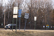
Major intersections
- U.S. Route 1U.S. Route 1U.S. Route 1 is a major north–south U.S. Highway that serves the East Coast of the United States. It runs 2,377 miles from Fort Kent, Maine at the Canadian border south to Key West, Florida. U.S. 1 generally parallels Interstate 95, though it is significantly farther west between...
in Rockingham, North CarolinaRockingham, North CarolinaRockingham is a city in Richmond County, North Carolina, United States named after the Marquis of Rockingham. The population was 9,672 at the 2000 census. It is the county seat of Richmond County... - Interstate 73Interstate 73Interstate 73 is a main route of the Interstate Highway System, currently located entirely within the U.S. state of North Carolina. It is part of a longer planned corridor, defined by various Federal laws to run from Myrtle Beach, South Carolina, to Grayling, Michigan, but only the part south of...
near Candor, North CarolinaCandor, North CarolinaCandor is a town in Montgomery County, North Carolina, United States. The population was 825 at the 2000 census. Candor is the home of the North Carolina Peach Festival, which is held every year on the third Saturday of July. The town's welcome sign reads: Welcome to Candor... - U.S. Route 64U.S. Route 64U.S. Route 64 is an east–west United States highway that runs for 2,326 miles from eastern North Carolina to just southwest of the Four Corners in northeast Arizona. The western terminus is at U.S. Route 160 in Teec Nos Pos, Arizona. The highway's eastern terminus is at NC 12 and U.S. Route...
in Asheboro, North CarolinaAsheboro, North CarolinaAsheboro is a city in Randolph County, North Carolina, United States. The population was 21,672 at the 2000 census. It is the county seat of Randolph County, and is the home of the state-owned North Carolina Zoo.-Geography:... - Interstate 85Interstate 85Interstate 85 is a major interstate highway in the Southeastern United States. Its current southern terminus is at an interchange with Interstate 65 in Montgomery, Alabama; its northern terminus interchanges with Interstate 95 in Petersburg, Virginia, near Richmond...
/U.S. Route 421U.S. Route 421U.S. Route 421 is a spur route of U.S. 21. It runs for from Michigan City, Indiana, at U.S. 20, to Fort Fisher in North Carolina. The highway goes through the cities of Indianapolis, Indiana, Lexington, Kentucky, Boone, North Carolina, Winston-Salem, North Carolina, Greensboro, North Carolina and...
in Greensboro, North CarolinaGreensboro, North CarolinaGreensboro is a city in the U.S. state of North Carolina. It is the third-largest city by population in North Carolina and the largest city in Guilford County and the surrounding Piedmont Triad metropolitan region. According to the 2010 U.S... - Interstate 40Interstate 40Interstate 40 is the third-longest major east–west Interstate Highway in the United States, after I-90 and I-80. Its western end is at Interstate 15 in Barstow, California; its eastern end is at a concurrency of U.S. Route 117 and North Carolina Highway 132 in Wilmington, North Carolina...
in Greensboro, North CarolinaGreensboro, North CarolinaGreensboro is a city in the U.S. state of North Carolina. It is the third-largest city by population in North Carolina and the largest city in Guilford County and the surrounding Piedmont Triad metropolitan region. According to the 2010 U.S... - U.S. Route 58U.S. Route 58U.S. Route 58 is an east–west U.S. Highway that runs for from U.S. Route 25E just northwest of Harrogate, Tennessee to U.S. Route 60 in Virginia Beach, Virginia. Until 1996, when the Cumberland Gap Tunnel opened, US 58 ran only inside the commonwealth of Virginia...
in Martinsville, VirginiaMartinsville, VirginiaMartinsville is an independent city which is surrounded by Henry County, Virginia, United States. The population was 13,821 in 2010. The Bureau of Economic Analysis combines the city of Martinsville with Henry County for statistical purposes... - Interstate 81Interstate 81Interstate 81 is an Interstate Highway in the eastern part of the United States. Its southern terminus is at Interstate 40 in Dandridge, Tennessee; its northern terminus is on Wellesley Island at the Canadian border, where the Thousand Islands Bridge connects it to Highway 401, the main freeway...
near Roanoke, VirginiaRoanoke, VirginiaRoanoke is an independent city in the Mid-Atlantic U.S. state of Virginia and is the tenth-largest city in the Commonwealth. It is located in the Roanoke Valley of the Roanoke Region of Virginia. The population within the city limits was 97,032 as of 2010... - U.S. Route 50U.S. Route 50U.S. Route 50 is a major east–west route of the U.S. Highway system, stretching just over from Ocean City, Maryland on the Atlantic Ocean to West Sacramento, California. Until 1972, when it was replaced by Interstate Highways west of the Sacramento area, it extended to San Francisco, near...
in New Creek, West VirginiaNew Creek, West VirginiaThe town of New Creek is an unincorporated community in Mineral County, West Virginia. It lies near the intersection of New Creek and U.S. Route 50, and is south of Keyser. The ZIP code for New Creek is 26743.... - U.S. Route 33U.S. Route 33U.S. Route 33 is a United States federal highway that runs northwest-southeast for 709 miles from northern Indiana to Richmond, Virginia, passing through Ohio and West Virginia en route. Although most odd-numbered U.S...
in Franklin, West VirginiaFranklin, West VirginiaFranklin is a town in Pendleton County, West Virginia, United States. The population was 797 at the 2000 census. It is the county seat of Pendleton County... - Interstate 68Interstate 68Interstate 68 is a Interstate highway in the U.S. states of West Virginia and Maryland, connecting in Morgantown to in Hancock. is also Corridor E of the Appalachian Development Highway System. From 1965 until the freeway's construction was completed in 1991, it was designated as...
/U.S. Route 40U.S. Route 40U.S. Route 40 is an east–west United States highway. As with most routes whose numbers end in a zero, U.S. 40 once traversed the entire United States. It is one of the original 1920s U.S. Highways, and its first termini were San Francisco, California, and Atlantic City, New Jersey...
in Cumberland, MarylandCumberland, MarylandCumberland is a city in the far western, Appalachian portion of Maryland, United States. It is the county seat of Allegany County, and the primary city of the Cumberland, MD-WV Metropolitan Statistical Area. At the 2010 census, the city had a population of 20,859, and the metropolitan area had a... - Interstate 70Interstate 70Interstate 70 is an Interstate Highway in the United States that runs from Interstate 15 near Cove Fort, Utah, to a Park and Ride near Baltimore, Maryland. It was the first Interstate Highway project in the United States. I-70 approximately traces the path of U.S. Route 40 east of the Rocky...
/Interstate 76Interstate 76 (east)Interstate 76 is an Interstate Highway in the United States, running 435 miles from an interchange with Interstate 71 west of Akron, Ohio, east to Interstate 295 near Camden, New Jersey....
/Pennsylvania TurnpikePennsylvania TurnpikeThe Pennsylvania Turnpike is a toll highway system operated by the Pennsylvania Turnpike Commission in the Commonwealth of Pennsylvania, United States. The three sections of the turnpike system total . The main section extends from Ohio to New Jersey and is long...
near Bedford, PennsylvaniaBedford, PennsylvaniaBedford is a borough in Bedford County, Pennsylvania, west of the State Capital, Harrisburg. It is the county seat of Bedford County. Bedford was established in the mid-18th century. Population counts follow: 1890, 2,242; 1900, 2,167; 1910, 2,385. The population was 3,141 at the 2000... - Interstate 99Interstate 99Interstate 99 is an intrastate Interstate Highway located in central Pennsylvania in the United States. The southern terminus of the route is at exit 146 of the Pennsylvania Turnpike north of Bedford, where the road continues south as U.S. Route 220 . The northern terminus is at...
from Bedford, PennsylvaniaBedford, PennsylvaniaBedford is a borough in Bedford County, Pennsylvania, west of the State Capital, Harrisburg. It is the county seat of Bedford County. Bedford was established in the mid-18th century. Population counts follow: 1890, 2,242; 1900, 2,167; 1910, 2,385. The population was 3,141 at the 2000...
to Bellefonte, PennsylvaniaBellefonte, PennsylvaniaBellefonte is a borough in Centre County, Pennsylvania, United States. It lies about twelve miles northeast of State College and is part of the State College, Pennsylvania Metropolitan Statistical Area... - U.S. Route 22U.S. Route 22 in PennsylvaniaU.S. Route 22 is an east–west route stretching from Cincinnati, Ohio in the west to Newark, New Jersey in the east. In Pennsylvania, the route runs for between the West Virginia state line at Washington County, where it is a limited-access expressway-grade route through the western suburbs...
near Altoona, PennsylvaniaAltoona, Pennsylvania-History:A major railroad town, Altoona was founded by the Pennsylvania Railroad in 1849 as the site for a shop complex. Altoona was incorporated as a borough on February 6, 1854, and as a city under legislation approved on April 3, 1867, and February 8, 1868... - U.S. Route 322U.S. Route 322U.S. Route 322 is a long, east–west United States Highway, traversing Ohio, Pennsylvania, and New Jersey. The road is a spur of U.S. Route 22 and one of the original highways from 1926...
in State College, PennsylvaniaState College, PennsylvaniaState College is the largest borough in Centre County in the U.S. state of Pennsylvania. It is the principal city of the State College, Pennsylvania Metropolitan Statistical Area which encompasses all of Centre County. As of the 2010 census, the borough population was 42,034, and roughly double... - Interstate 80Interstate 80Interstate 80 is the second-longest Interstate Highway in the United States, following Interstate 90. It is a transcontinental artery running from downtown San Francisco, California to Teaneck, New Jersey in the New York City Metropolitan Area...
near Bellefonte, PennsylvaniaBellefonte, PennsylvaniaBellefonte is a borough in Centre County, Pennsylvania, United States. It lies about twelve miles northeast of State College and is part of the State College, Pennsylvania Metropolitan Statistical Area... - Interstate 180Interstate 180 (Pennsylvania)Interstate 180 is a spur highway that connects Williamsport, Pennsylvania to Interstate 80 near Milton, Pennsylvania. The length of the highway is . It was also the designation of present-day Interstate 176 between Morgantown, Pennsylvania and Reading, when the Pennsylvania Turnpike carried the...
/U.S. Route 15U.S. Route 15U.S. Route 15 is a -long United States highway, designated along South Carolina, North Carolina, Virginia, Maryland, Pennsylvania, and New York. The route is signed north–south, from U.S. Route 17 Alternate in Walterboro, South Carolina to Interstate 86 and NY 17 in Painted Post, New York.US...
in Williamsport, PennsylvaniaWilliamsport, PennsylvaniaWilliamsport is a city in and the county seat of Lycoming County, Pennsylvania in the United States. In 2009, the population was estimated at 29,304... - U.S. Route 6U.S. Route 6 in PennsylvaniaU.S. Route 6 travels east–west near the north edge of the U.S. state of Pennsylvania from the Ohio state line near Pymatuning Reservoir east to the Mid-Delaware Bridge over the Delaware River into Port Jervis, New York. It is the longest highway segment in the Commonwealth. Most of it is a...
in Towanda, PennsylvaniaTowanda, PennsylvaniaTowanda is a borough in and the county seat of Bradford County, Pennsylvania, United States, northwest of Wilkes Barre, on the Susquehanna River. The name means "burial ground" in the Algonquian language... - New York State Route 17New York State Route 17New York State Route 17 is a state highway that extends for through the Southern Tier and Downstate regions of New York in the United States...
in South Waverly, PennsylvaniaSouth Waverly, PennsylvaniaSouth Waverly is a borough in Bradford County, Pennsylvania, United States. The population was 987 at the 2000 census. It runs into Sayre, Pennsylvania in the south and to the north Waverly in Tioga County in New York...
Exit list
A segment of US 220 in PennsylvaniaPennsylvania
The Commonwealth of Pennsylvania is a U.S. state that is located in the Northeastern and Mid-Atlantic regions of the United States. The state borders Delaware and Maryland to the south, West Virginia to the southwest, Ohio to the west, New York and Ontario, Canada, to the north, and New Jersey to...
is a limited-access highway.
| County | Location | Mile | Exit | Destinations | Notes |
|---|---|---|---|---|---|
| Centre Centre County, Pennsylvania Centre County is a county located in the U.S. state of Pennsylvania. It is part of the State College, Pennsylvania Metropolitan Statistical Area. As of 2010, the population was 153,990.... |
Worth Township Worth Township, Centre County, Pennsylvania Worth Township is a township in Centre County, Pennsylvania, United States. It is part of the State College, Pennsylvania Metropolitan Statistical Area... |
Port Matilda Port Matilda, Pennsylvania Port Matilda is a borough in Centre County, Pennsylvania, United States. It is part of the State College, Pennsylvania Metropolitan Statistical Area... |
|||
| Southbound exit, northbound entrance. US 322 joins northbound and leaves southbound. |
|||||
| Patton Township Patton Township, Pennsylvania Patton Township is a township in Centre County, Pennsylvania, United States. It is part of the State College, Pennsylvania Metropolitan Statistical Area. The population was 15,311 at the 2010 census, which is a 34.1% increase from the 2000 census... |
Northbound exit, southbound entrance. | ||||
| Valley Vista Drive | Southbound exit, northbound entrance. | ||||
| Toftrees/Woodycrest | |||||
| College Township College Township, Pennsylvania College Township is a township in Centre County, Pennsylvania, United States. It is part of the State College, Pennsylvania Metropolitan Statistical Area. The population was 9,521 at the 2010 census, which was a 12.2% increase from the 2000 census... |
US 322 leaves northbound and joins southbound. | ||||
| Innovation Park Innovation Park Innovation Park may refer to:* Innovation Park * Innovation Park * Innovation Park... /Penn State University |
Southbound exit, northbound entrance. | ||||
| Benner Township Benner Township, Pennsylvania Benner Township is a township in Centre County, Pennsylvania, United States. It is part of the State College, Pennsylvania Metropolitan Statistical Area... |
Dale Summit/Nittany Mall Nittany Mall Nittany Mall is an enclosed shopping mall in State College, Pennsylvania. The mall is noteworthy because it is the only enclosed shopping mall in the State College region.-Anchors:*J.C. Penney*Sears*Bon-Ton... |
State Correctional Institution - Rockview State Correctional Institution - Rockview The State Correctional Institution at Rockview, commonly referred to as Rockview, is a Pennsylvania Department of Corrections prison located in Benner Township, Pennsylvania, away from Bellefonte.... area. Do not stop vehicle for next 2 miles (3.2 km). |
|||
| Spring Township Spring Township, Centre County, Pennsylvania Spring Township is a township in Centre County, Pennsylvania, United States. It is part of the State College, Pennsylvania Metropolitan Statistical Area... |
Harrison Road | Northbound exit, southbound entrance. | |||
| PA 26 joins northbound and leaves southbound. | |||||
| Exit 161 (I-80). US 220 joins I-80 northbound and leaves southbound. Future four-way interchange. |