

Fair Play Men
Encyclopedia
The Fair Play Men were illegal settler
s (squatters) who established their own system of self-rule from 1773 to 1785 in the West Branch Susquehanna River
valley of Pennsylvania
in what is now the United States
. Because they settled in territory claimed by Native Americans
, they had no recourse to the Pennsylvania colonial government. Accordingly they established what was known as the Fair Play System, with three elected commissioners who ruled on land claims and other issues for the group. In a remarkable coincidence, the Fair Play Men made their own Declaration of Independence
from Britain
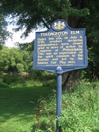
on July 4, 1776 beneath the "Tiadaghton Elm" on the banks of Pine Creek
.
in the Treaty of Fort Stanwix
of 1768, opening new lands in Pennsylvania and New York
for settlement, including what is now Lycoming County, Pennsylvania
. As the crow flies
, Lycoming County is about 100 mi (160 km) northwest of Philadelphia and about 165 mi (265 km) east-northeast of Pittsburgh
.
 However, some of the treaty's Line of Property
(or Purchase Line
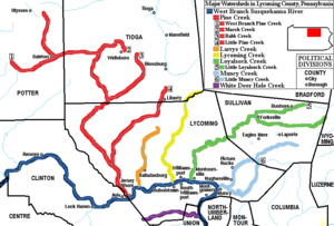
) border along the West Branch Susquehanna River was disputed. Part of the western border which divided colonial and Native American lands north of the river was defined by "Tiadaghton Creek". The colonists claimed this was Pine Creek
(further west, giving them more land), the Iroquois and other tribes claimed it was Lycoming Creek
(further east). The colonial government recognized the tribal claim and so all land west of Lycoming Creek was considered Native American and off bounds for settlement. Despite this, illegal settlers settled in the disputed area along the West Branch Susquehanna River, the west bank of Lycoming Creek, Larrys Creek
, and especially at the mouth of Pine Creek.
started in April, 1775. Men from the area volunteered to serve in the Continental Army
that year. Most of the settlers in the West Branch Susquehanna River valley were for the revolution. On July 4, 1776 the Fair Play Men met on the west bank of Pine Creek near the mouth of the West Branch Susquehanna River and declared their Independence from Britain. The traditional site for the declaration was beneath the "Tiadaghton Elm
" tree, which stood until the 1970s in what is now Clinton County, Pennsylvania
. This was west of Pine Creek in what was clearly Native American land.
Afterwards the Fair Play Men met in their own Fort Horn (near the elm tree) and chose to send two men with the news to Philadelphia, not knowing that the Second Continental Congress
had declared independence there the same day. The two messengers, Patrick Gilfillen and Michael Quigley Jr., were ambushed and robbed by Native Americans and later jailed by Loyalists
, but escaped and made it to Philadelphia on July 10. They returned a short time later to bring word of the United States Declaration of Independence
.
 In the American Revolutionary War, settlements throughout the Susquehanna valley were attacked by Loyalists
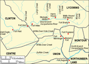
and Native Americans allied with the British. In the early summer of 1778 news came of a group of Native American warriors, perhaps accompanied by Loyalist and British soldiers, heading for the West Branch Susquehanna River valley to destroy settlements. There were many smaller incidents of violence against settlers, but on June 10, 1778 a party of sixteen settlers were attacked in what is now Williamsport
. In what became known as the "Plum Tree Massacre", twelve of the sixteen were killed and scalped
, including two women and six children. The Wyoming Valley Massacre occurred on July 3, 1778 (near what is now Wilkes-Barre
). This news caused the local authorities to order the evacuation of the whole West Branch valley.
At least two riders braved attacks to warn their fellow settlers. Rachel Silverthorn volunteered (when no man would) to leave the relative safety of Fort Muncy (in Muncy Township
). She rode along Muncy Creek
and the Wyalusing Path
and warned settlers, who fled to the safety of Fort Muncy. Her own family's cabin was later burnt to the ground. Robert Covenhoven, who had served under George Washington
in the Continental Army, rode west along the ridge
of Bald Eagle Mountain
to warn settlers at Fort Antes (opposite what is now Jersey Shore
) and the western part of the valley. Covenhoven is listed as a Fair Play Man and one of the signers of the Tiadaghton Declaration of Independence.
Most settlers had already gathered at five small forts for safety, but now the forts and the settlers' homes and fields were abandoned, with livestock driven along and a few possessions floated on rafts on the river east to what is now Muncy
, then further south to Fort Augusta at what is now Sunbury
. The abandoned property was burnt by the attackers. Some settlers reported fleeing at night with the glow of their burning settlements lighting the sky behind them. Fort Horn and the other Fair Play Men settlements were all destroyed.
Some settlers soon returned, only to flee a second time in the summer of 1779 in the "Little Runaway", when another force of Native Americans and British soldiers attacked the valley again. Also in 1779, Sullivan's Expedition destroyed at least forty Native American villages in New York and helped reduce attacks to stabilize the area and encourage resettlement.
 The Fair Play Men and their system continued after the end of the war. In 1784, a second Treaty at Fort Stanwix ceded the Native American lands to the new government of the United States (and recognized Pine Creek as "Tiadaghton Creek"). When the land office opened in May 1785, the Fair Play men were no longer illegal settlers and their existing land claims were recognized.
In the absence of primary written records, some modern historians have doubted whether the actual Tiadaghton Declaration of Independence took place on July 4, 1776, or whether it was made before knowledge of the United States Declaration of Independence in Philadelphia reached the Fair Play Men.
The closest borough
to the "Tiadaghton Elm" site is Jersey Shore
in Lycoming County, which has a week-long Town Meeting each year over the Fourth of July. The Town Meeting includes a procession of people dressed as the Fair Play Men and a Tiadaghton Elm ceremony.
Settler
A settler is a person who has migrated to an area and established permanent residence there, often to colonize the area. Settlers are generally people who take up residence on land and cultivate it, as opposed to nomads...
s (squatters) who established their own system of self-rule from 1773 to 1785 in the West Branch Susquehanna River
West Branch Susquehanna River
The West Branch Susquehanna River is one of the two principal branches, along with the North Branch, of the Susquehanna River in the northeastern United States. The North Branch, which rises in upstate New York, is generally regarded as the extension of the main branch, with the shorter West Branch...
valley of Pennsylvania
Pennsylvania
The Commonwealth of Pennsylvania is a U.S. state that is located in the Northeastern and Mid-Atlantic regions of the United States. The state borders Delaware and Maryland to the south, West Virginia to the southwest, Ohio to the west, New York and Ontario, Canada, to the north, and New Jersey to...
in what is now the United States
United States
The United States of America is a federal constitutional republic comprising fifty states and a federal district...
. Because they settled in territory claimed by Native Americans
Native Americans in the United States
Native Americans in the United States are the indigenous peoples in North America within the boundaries of the present-day continental United States, parts of Alaska, and the island state of Hawaii. They are composed of numerous, distinct tribes, states, and ethnic groups, many of which survive as...
, they had no recourse to the Pennsylvania colonial government. Accordingly they established what was known as the Fair Play System, with three elected commissioners who ruled on land claims and other issues for the group. In a remarkable coincidence, the Fair Play Men made their own Declaration of Independence
Declaration of independence
A declaration of independence is an assertion of the independence of an aspiring state or states. Such places are usually declared from part or all of the territory of another nation or failed nation, or are breakaway territories from within the larger state...
from Britain
United Kingdom
The United Kingdom of Great Britain and Northern IrelandIn the United Kingdom and Dependencies, other languages have been officially recognised as legitimate autochthonous languages under the European Charter for Regional or Minority Languages...
on July 4, 1776 beneath the "Tiadaghton Elm" on the banks of Pine Creek
Pine Creek (Pennsylvania)
Pine Creek is a tributary of the West Branch Susquehanna River in Potter, Tioga, Lycoming, and Clinton counties in Pennsylvania in the United States. The creek is long...
.
The 1768 Treaty of Fort Stanwix
The British colonial government purchased land from the IroquoisIroquois
The Iroquois , also known as the Haudenosaunee or the "People of the Longhouse", are an association of several tribes of indigenous people of North America...
in the Treaty of Fort Stanwix
Treaty of Fort Stanwix
The Treaty of Fort Stanwix was an important treaty between North American Indians and the British Empire. It was signed in 1768 at Fort Stanwix, located in present-day Rome, New York...
of 1768, opening new lands in Pennsylvania and New York
New York
New York is a state in the Northeastern region of the United States. It is the nation's third most populous state. New York is bordered by New Jersey and Pennsylvania to the south, and by Connecticut, Massachusetts and Vermont to the east...
for settlement, including what is now Lycoming County, Pennsylvania
Lycoming County, Pennsylvania
-Appalachian Mountains and Allegheny Plateau:Lycoming County is divided between the Appalachian Mountains in the south, the dissected Allegheny Plateau in the north and east, and the valley of the West Branch Susquehanna River between these.-West Branch Susquehanna River:The West Branch of the...
. As the crow flies
As the crow flies
"As the crow flies" or beelining is an idiom for the shortest route between two points; the geodesic distance.An example is the great-circle distance between Key West and Pensacola, at either end of the U.S...
, Lycoming County is about 100 mi (160 km) northwest of Philadelphia and about 165 mi (265 km) east-northeast of Pittsburgh
Pittsburgh, Pennsylvania
Pittsburgh is the second-largest city in the US Commonwealth of Pennsylvania and the county seat of Allegheny County. Regionally, it anchors the largest urban area of Appalachia and the Ohio River Valley, and nationally, it is the 22nd-largest urban area in the United States...
.
Line of Property
The Line of Property is the name commonly given to the line dividing Indian from British Colonial lands established in the Treaty of Fort Stanwix of 1768...
(or Purchase Line
Purchase line
The Purchase Line is the name commonly given to the line dividing Indian from British Colonial lands established in the Treaty of Fort Stanwix of 1768 in western Pennsylvania...
) border along the West Branch Susquehanna River was disputed. Part of the western border which divided colonial and Native American lands north of the river was defined by "Tiadaghton Creek". The colonists claimed this was Pine Creek
Pine Creek (Pennsylvania)
Pine Creek is a tributary of the West Branch Susquehanna River in Potter, Tioga, Lycoming, and Clinton counties in Pennsylvania in the United States. The creek is long...
(further west, giving them more land), the Iroquois and other tribes claimed it was Lycoming Creek
Lycoming Creek
Lycoming Creek is a tributary of the West Branch Susquehanna River located in Tioga and Lycoming counties in Pennsylvania in the United States.-Geography:...
(further east). The colonial government recognized the tribal claim and so all land west of Lycoming Creek was considered Native American and off bounds for settlement. Despite this, illegal settlers settled in the disputed area along the West Branch Susquehanna River, the west bank of Lycoming Creek, Larrys Creek
Larrys Creek
Larrys Creek is a tributary of the West Branch Susquehanna River in Lycoming County in the U.S. state of Pennsylvania. A part of the Chesapeake Bay drainage basin, its watershed drains in six townships and a borough...
, and especially at the mouth of Pine Creek.
The Fair Play system
The settlers elected three commissioners each March who were responsible that everyone was dealt with fairly (hence the name "fair play"). Most of their rulings seem to have dealt with property issues, but they dealt with any legal or criminal cases in the Fair Play area. They granted permission for new settlers to enter the area, could take away a settler's land claim if they were absent more than six weeks (except for military service), and could expel a person (by setting them adrift in a canoe on the river). The commissioners' decisions were final and supposedly were never challenged. In 1776 the three commissioners of the Fair Play Men were Bratton Caldwell, John Walker, and James Brandon. They are the only commissioners whose names are now known and it is conjectured that they were the only three for the duration of the Fair Play system.The Pine Creek Declaration of Independence
The American Revolutionary WarAmerican Revolutionary War
The American Revolutionary War , the American War of Independence, or simply the Revolutionary War, began as a war between the Kingdom of Great Britain and thirteen British colonies in North America, and ended in a global war between several European great powers.The war was the result of the...
started in April, 1775. Men from the area volunteered to serve in the Continental Army
Continental Army
The Continental Army was formed after the outbreak of the American Revolutionary War by the colonies that became the United States of America. Established by a resolution of the Continental Congress on June 14, 1775, it was created to coordinate the military efforts of the Thirteen Colonies in...
that year. Most of the settlers in the West Branch Susquehanna River valley were for the revolution. On July 4, 1776 the Fair Play Men met on the west bank of Pine Creek near the mouth of the West Branch Susquehanna River and declared their Independence from Britain. The traditional site for the declaration was beneath the "Tiadaghton Elm
Elm
Elms are deciduous and semi-deciduous trees comprising the genus Ulmus in the plant family Ulmaceae. The dozens of species are found in temperate and tropical-montane regions of North America and Eurasia, ranging southward into Indonesia. Elms are components of many kinds of natural forests...
" tree, which stood until the 1970s in what is now Clinton County, Pennsylvania
Clinton County, Pennsylvania
As of the census of 2000, there were 37,914 people, 14,773 households, and 9,927 families residing in the county. The population density was 43 people per square mile . There were 18,166 housing units at an average density of 20 per square mile...
. This was west of Pine Creek in what was clearly Native American land.
Afterwards the Fair Play Men met in their own Fort Horn (near the elm tree) and chose to send two men with the news to Philadelphia, not knowing that the Second Continental Congress
Second Continental Congress
The Second Continental Congress was a convention of delegates from the Thirteen Colonies that started meeting on May 10, 1775, in Philadelphia, Pennsylvania, soon after warfare in the American Revolutionary War had begun. It succeeded the First Continental Congress, which met briefly during 1774,...
had declared independence there the same day. The two messengers, Patrick Gilfillen and Michael Quigley Jr., were ambushed and robbed by Native Americans and later jailed by Loyalists
Loyalist (American Revolution)
Loyalists were American colonists who remained loyal to the Kingdom of Great Britain during the American Revolutionary War. At the time they were often called Tories, Royalists, or King's Men. They were opposed by the Patriots, those who supported the revolution...
, but escaped and made it to Philadelphia on July 10. They returned a short time later to bring word of the United States Declaration of Independence
United States Declaration of Independence
The Declaration of Independence was a statement adopted by the Continental Congress on July 4, 1776, which announced that the thirteen American colonies then at war with Great Britain regarded themselves as independent states, and no longer a part of the British Empire. John Adams put forth a...
.
The Big Runaway
Loyalist (American Revolution)
Loyalists were American colonists who remained loyal to the Kingdom of Great Britain during the American Revolutionary War. At the time they were often called Tories, Royalists, or King's Men. They were opposed by the Patriots, those who supported the revolution...
and Native Americans allied with the British. In the early summer of 1778 news came of a group of Native American warriors, perhaps accompanied by Loyalist and British soldiers, heading for the West Branch Susquehanna River valley to destroy settlements. There were many smaller incidents of violence against settlers, but on June 10, 1778 a party of sixteen settlers were attacked in what is now Williamsport
Williamsport, Pennsylvania
Williamsport is a city in and the county seat of Lycoming County, Pennsylvania in the United States. In 2009, the population was estimated at 29,304...
. In what became known as the "Plum Tree Massacre", twelve of the sixteen were killed and scalped
Scalping
Scalping is the act of removing another person's scalp or a portion of their scalp, either from a dead body or from a living person. The initial purpose of scalping was to provide a trophy of battle or portable proof of a combatant's prowess in war...
, including two women and six children. The Wyoming Valley Massacre occurred on July 3, 1778 (near what is now Wilkes-Barre
Wilkes-Barre, Pennsylvania
Wilkes-Barre is a city in the U.S. state of Pennsylvania, the county seat of Luzerne County. It is at the center of the Wyoming Valley area and is one of the principal cities in the Scranton/Wilkes-Barre metropolitan area, which had a population of 563,631 as of the 2010 Census...
). This news caused the local authorities to order the evacuation of the whole West Branch valley.
At least two riders braved attacks to warn their fellow settlers. Rachel Silverthorn volunteered (when no man would) to leave the relative safety of Fort Muncy (in Muncy Township
Muncy Township, Pennsylvania
Muncy Township is a township in Lycoming County, Pennsylvania, in the United States. The population was 1,059 at the 2000 census. It is part of the Williamsport, Pennsylvania Metropolitan Statistical Area.The unincorporated village of Pennsdale is located here...
). She rode along Muncy Creek
Muncy Creek
Muncy Creek is a tributary of the West Branch Susquehanna River in Lycoming and Sullivan counties, Pennsylvania, USA. Little Muncy Creek is its major tributary.-Course:The creek is long. For much of its length, U.S. Route 220 runs parallel to Muncy Creek....
and the Wyalusing Path
Wyalusing Path
The Wyalusing Path or trail was a historical trace that ran from what is now Wyalusing to the Native American village of Canaserage in Pennsylvania in the United States...
and warned settlers, who fled to the safety of Fort Muncy. Her own family's cabin was later burnt to the ground. Robert Covenhoven, who had served under George Washington
George Washington
George Washington was the dominant military and political leader of the new United States of America from 1775 to 1799. He led the American victory over Great Britain in the American Revolutionary War as commander-in-chief of the Continental Army from 1775 to 1783, and presided over the writing of...
in the Continental Army, rode west along the ridge
Ridge-and-valley Appalachians
The Ridge-and-Valley Appalachians, also called the Ridge and Valley Province or the Valley and Ridge Appalachians, are a physiographic province of the larger Appalachian division and are also a belt within the Appalachian Mountains extending from southeastern New York through northwestern New...
of Bald Eagle Mountain
Bald Eagle Mountain
Bald Eagle Mountain, once known locally as Muncy Mountain, is a stratigraphic ridge in central Pennsylvania, United States, running east of the Allegheny Front and northwest of Mount Nittany. It lies along the southeast side of Bald Eagle Creek, and south of the West Branch Susquehanna River, and...
to warn settlers at Fort Antes (opposite what is now Jersey Shore
Jersey Shore, Pennsylvania
Jersey Shore is a borough in Lycoming County, Pennsylvania, United States. It is on the West Branch Susquehanna River, west by south of Williamsport. It is part of the Williamsport, Pennsylvania Metropolitan Statistical Area. In the past, Jersey Shore held farms, railroad shops, cigar factories, a...
) and the western part of the valley. Covenhoven is listed as a Fair Play Man and one of the signers of the Tiadaghton Declaration of Independence.
Most settlers had already gathered at five small forts for safety, but now the forts and the settlers' homes and fields were abandoned, with livestock driven along and a few possessions floated on rafts on the river east to what is now Muncy
Muncy, Pennsylvania
For other places named 'Muncy', please see Muncy .Muncy is a borough in Lycoming County, Pennsylvania, in the United States. The name Muncy comes from the Munsee Indians who once lived in the area. The population was 2,663 at the 2000 census. It is part of the Williamsport, Pennsylvania...
, then further south to Fort Augusta at what is now Sunbury
Sunbury, Pennsylvania
Sunbury is a city in Northumberland County, Pennsylvania, United States. The city is located on the east bank of the Susquehanna River, just downstream of the confluence of its main and West branches. The population was 9,905 at the 2010 census...
. The abandoned property was burnt by the attackers. Some settlers reported fleeing at night with the glow of their burning settlements lighting the sky behind them. Fort Horn and the other Fair Play Men settlements were all destroyed.
Some settlers soon returned, only to flee a second time in the summer of 1779 in the "Little Runaway", when another force of Native Americans and British soldiers attacked the valley again. Also in 1779, Sullivan's Expedition destroyed at least forty Native American villages in New York and helped reduce attacks to stabilize the area and encourage resettlement.
After the war
Legacy
There are no original written records from the Fair Play Men or their Declaration of Independence, although many later accounts exist. The two main theories that have been advanced to explain this are: first that any records were destroyed in the Great Runaway (only one house survived in the whole West Branch valley); or second that they kept no records to avoid incriminating themselves as they were illegal settlers. The riders to Philadelphia are supposed to have lost their copy of the Declaration of Independence when ambushed or later when jailed.In the absence of primary written records, some modern historians have doubted whether the actual Tiadaghton Declaration of Independence took place on July 4, 1776, or whether it was made before knowledge of the United States Declaration of Independence in Philadelphia reached the Fair Play Men.
The closest borough
Borough
A borough is an administrative division in various countries. In principle, the term borough designates a self-governing township although, in practice, official use of the term varies widely....
to the "Tiadaghton Elm" site is Jersey Shore
Jersey Shore, Pennsylvania
Jersey Shore is a borough in Lycoming County, Pennsylvania, United States. It is on the West Branch Susquehanna River, west by south of Williamsport. It is part of the Williamsport, Pennsylvania Metropolitan Statistical Area. In the past, Jersey Shore held farms, railroad shops, cigar factories, a...
in Lycoming County, which has a week-long Town Meeting each year over the Fourth of July. The Town Meeting includes a procession of people dressed as the Fair Play Men and a Tiadaghton Elm ceremony.