

Line of Property
Encyclopedia
British North America
British North America is a historical term. It consisted of the colonies and territories of the British Empire in continental North America after the end of the American Revolutionary War and the recognition of American independence in 1783.At the start of the Revolutionary War in 1775 the British...
Colonial lands established in the Treaty of Fort Stanwix
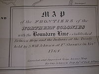
Treaty of Fort Stanwix
The Treaty of Fort Stanwix was an important treaty between North American Indians and the British Empire. It was signed in 1768 at Fort Stanwix, located in present-day Rome, New York...
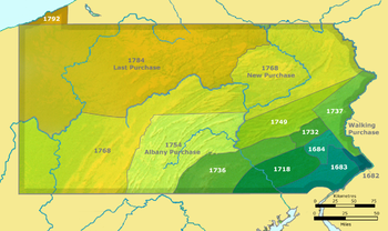
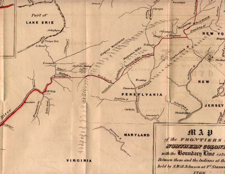
of 1768. In western Pennsylvania
Pennsylvania
The Commonwealth of Pennsylvania is a U.S. state that is located in the Northeastern and Mid-Atlantic regions of the United States. The state borders Delaware and Maryland to the south, West Virginia to the southwest, Ohio to the west, New York and Ontario, Canada, to the north, and New Jersey to...
it is referred to as the Purchase line
Purchase line
The Purchase Line is the name commonly given to the line dividing Indian from British Colonial lands established in the Treaty of Fort Stanwix of 1768 in western Pennsylvania...
.
Treaty description of the line
As written with original spellings and place names; (modern names in parentheses):- "Beginning at the Mouth of the Cherokee or Hogohee River" (Tennessee RiverTennessee RiverThe Tennessee River is the largest tributary of the Ohio River. It is approximately 652 miles long and is located in the southeastern United States in the Tennessee Valley. The river was once popularly known as the Cherokee River, among other names...
) "where it empties into the River Ohio" (at Paducah, KentuckyPaducah, KentuckyPaducah is the largest city in Kentucky's Jackson Purchase Region and the county seat of McCracken County, Kentucky, United States. It is located at the confluence of the Tennessee River and the Ohio River, halfway between the metropolitan areas of St. Louis, Missouri, to the west and Nashville,...
) - "& running from thence upwards along the South side of said River to KittanningKittanning, PennsylvaniaKittanning is a borough and the county seat of Armstrong County, Pennsylvania in the United States. It is situated northeast of Pittsburgh, along the east bank of the Allegheny River. The name means "at the great stream" in the Delaware language...
, which is above Fort Pitt" (Pittsburgh, PennsylvaniaPittsburgh, PennsylvaniaPittsburgh is the second-largest city in the US Commonwealth of Pennsylvania and the county seat of Allegheny County. Regionally, it anchors the largest urban area of Appalachia and the Ohio River Valley, and nationally, it is the 22nd-largest urban area in the United States...
) - "from thence a direct Line to the nearest Fork of the west branch of SusquehannaWest Branch Susquehanna RiverThe West Branch Susquehanna River is one of the two principal branches, along with the North Branch, of the Susquehanna River in the northeastern United States. The North Branch, which rises in upstate New York, is generally regarded as the extension of the main branch, with the shorter West Branch...
- "thence through the Allegany Mountains along the south side of the said West Branch until it comes opposite to the mouth of a creek called Tiadaghton" (Pine CreekPine Creek (Pennsylvania)Pine Creek is a tributary of the West Branch Susquehanna River in Potter, Tioga, Lycoming, and Clinton counties in Pennsylvania in the United States. The creek is long...
just west of Jersey Shore, PennsylvaniaJersey Shore, PennsylvaniaJersey Shore is a borough in Lycoming County, Pennsylvania, United States. It is on the West Branch Susquehanna River, west by south of Williamsport. It is part of the Williamsport, Pennsylvania Metropolitan Statistical Area. In the past, Jersey Shore held farms, railroad shops, cigar factories, a...
) - "thence across the West Branch along the South Side of that Creek"
- "and along the North Side of Burnetts Hills to a Creek called Awandae" (Towanda CreekTowanda Creekthumb|right|250px|Towanda CreekTowanda Creek is a tributary of the Susquehanna River in Bradford County, Pennsylvania, in the United States.Towanda Creek rises in the southwest corner of Bradford County, south of Canton, and flows east, joining the Susquehanna River just below...
) - "thence down the same to the East Branch of SasquehannaSusquehanna RiverThe Susquehanna River is a river located in the northeastern United States. At long, it is the longest river on the American east coast that drains into the Atlantic Ocean, and with its watershed it is the 16th largest river in the United States, and the longest river in the continental United...
" (at Towanda, PennsylvaniaTowanda, PennsylvaniaTowanda is a borough in and the county seat of Bradford County, Pennsylvania, United States, northwest of Wilkes Barre, on the Susquehanna River. The name means "burial ground" in the Algonquian language...
) - "& across the same and up the East side of that River to Oswegy" (Owego, New YorkOwego (village), New YorkOwego is a village in and the county seat of Tioga County, New York, USA. The population was 3,911 at the 2000 census. It is part of the Binghamton Metropolitan Statistical Area...
) - "from thence East to Delawar River" (Delaware RiverDelaware RiverThe Delaware River is a major river on the Atlantic coast of the United States.A Dutch expedition led by Henry Hudson in 1609 first mapped the river. The river was christened the South River in the New Netherland colony that followed, in contrast to the North River, as the Hudson River was then...
) - "and up that River to opposite where Tianaderha" (Unadilla RiverUnadilla RiverThe Unadilla River in New York State flows from south of Utica to the village of Sidney, where it flows into the Susquehanna River, which eventually empties into the Chesapeake Bay, an arm of the Atlantic Ocean....
) "falls into Sasquehanna" (Susquehanna RiverSusquehanna RiverThe Susquehanna River is a river located in the northeastern United States. At long, it is the longest river on the American east coast that drains into the Atlantic Ocean, and with its watershed it is the 16th largest river in the United States, and the longest river in the continental United...
) - "thence to Tianaderha" (New Berlin, New YorkNew Berlin, New YorkNew Berlin, New York is the name of two locations in Chenango County, New York:*New Berlin , New York*New Berlin , New York...
?) "and up the West side of the West branch" (Beaver Creek) "to the head thereof" - "& thence by a direct Line to Canada Creek, where it empties into the Wood Creek at the West of the Carrying Place beyond Fort Stanwix" (Rome, New YorkRome, New YorkRome is a city in Oneida County, New York, United States. It is located in north-central or "upstate" New York. The population was 44,797 at the 2010 census. It is in New York's 24th congressional district. In 1758, British forces began construction of Fort Stanwix at this strategic location, but...
).
Actual line
The starting point is the confluence of the Tennessee RiverTennessee River
The Tennessee River is the largest tributary of the Ohio River. It is approximately 652 miles long and is located in the southeastern United States in the Tennessee Valley. The river was once popularly known as the Cherokee River, among other names...
with the Ohio River
Ohio River
The Ohio River is the largest tributary, by volume, of the Mississippi River. At the confluence, the Ohio is even bigger than the Mississippi and, thus, is hydrologically the main stream of the whole river system, including the Allegheny River further upstream...
at Paducah, Kentucky. The line follows the south bank of the Ohio almost the entire length of Kentucky
Kentucky
The Commonwealth of Kentucky is a state located in the East Central United States of America. As classified by the United States Census Bureau, Kentucky is a Southern state, more specifically in the East South Central region. Kentucky is one of four U.S. states constituted as a commonwealth...
and all of West Virginia
West Virginia
West Virginia is a state in the Appalachian and Southeastern regions of the United States, bordered by Virginia to the southeast, Kentucky to the southwest, Ohio to the northwest, Pennsylvania to the northeast and Maryland to the east...
to Pittsburgh where the Allegheny River
Allegheny River
The Allegheny River is a principal tributary of the Ohio River; it is located in the Eastern United States. The Allegheny River joins with the Monongahela River to form the Ohio River at the "Point" of Point State Park in Downtown Pittsburgh, Pennsylvania...
joins the Monongahela River
Monongahela River
The Monongahela River is a river on the Allegheny Plateau in north-central West Virginia and southwestern Pennsylvania in the United States...
to form the Ohio. It then follows the Allegheny River north.
For the line from Kittanning, Pennsylvania
Kittanning, Pennsylvania
Kittanning is a borough and the county seat of Armstrong County, Pennsylvania in the United States. It is situated northeast of Pittsburgh, along the east bank of the Allegheny River. The name means "at the great stream" in the Delaware language...
to the "nearest fork" of the west branch of the Susquehanna River
Susquehanna River
The Susquehanna River is a river located in the northeastern United States. At long, it is the longest river on the American east coast that drains into the Atlantic Ocean, and with its watershed it is the 16th largest river in the United States, and the longest river in the continental United...
at Cherry Tree, Pennsylvania
Cherry Tree, Pennsylvania
Cherry Tree is a borough in Indiana County, Pennsylvania, United States. The population was 443 at the 2000 census.-History:Cherry Tree is situated mostly in a valley near the headwaters of West Branch of the Susquehanna River where the river is fed by Cush Cushion Creek.Cherry Tree was originally...
, see the article on the Purchase line.
From Cherry Tree the line followed the West Branch on its sinuous course due north and then northeast to Clearfield, Pennsylvania
Clearfield, Pennsylvania
Clearfield is a borough in Clearfield County, Pennsylvania, United States. The population was 6,631 at the 2000 census. It is the county seat of Clearfield County.-Geography:Clearfield is located at ....
and then meandered through the deep gorges of the Alleghenies past Renovo, Pennsylvania
Renovo, Pennsylvania
Renovo is a borough in Clinton County, Pennsylvania, northwest of Lock Haven. Deposits of bituminous coal and fire clay are in the region. In 1900, 4,082 people lived there, and in 1910, 4,621 lived there...
, exiting the mountains into Bald Eagle Valley
Bald Eagle Valley
The Bald Eagle Valley of central Pennsylvania, United States is the low lying area draining into the Bald Eagle Creek between the Allegheny Front and the Bald Eagle Mountain ridge, south of the West Branch Susquehanna River, in the Ridge-and-valley Appalachians...
at Lock Haven, Pennsylvania
Lock Haven, Pennsylvania
The city of Lock Haven is the county seat of Clinton County, in the U.S. state of Pennsylvania. Located near the confluence of the West Branch Susquehanna River and Bald Eagle Creek, it is the principal city of the Lock Haven, Pennsylvania, micropolitan statistical area, itself part of the...
, and then east-northeast to the confluence with Pine Creek at Jersey Shore, Pennsylvania.
The next section of the line is difficult to fix, since the "Burnetts Hills" of the treaty never been positively identified. Also, the distance to follow Pine Creek, let alone which of the forks of that Creek to follow, is not specified.
The only part of this section that can be definitely established is the lowest (easternmost) portion of Towanda Creek
Towanda Creek
thumb|right|250px|Towanda CreekTowanda Creek is a tributary of the Susquehanna River in Bradford County, Pennsylvania, in the United States.Towanda Creek rises in the southwest corner of Bradford County, south of Canton, and flows east, joining the Susquehanna River just below...
from Monroeton, Pennsylvania
Monroe, Pennsylvania
Monroe is a borough in Bradford County, Pennsylvania, United States. The population was 514 at the 2000 census.-Geography:Monroe is located at ....
to Towanda, Pennsylvania.
From Jersey Shore to this point there are two competing interpretations.
The first interpretation is that the line was intended to follow the principal (west) branch of Towanda Creek which runs eastward along the base of the very prominent north face of Barclay Mountain (which forms the northernmost range of the Endless Mountains
Endless Mountains
The Endless Mountains are a chain of mountains in northeastern Pennsylvania. The Endless Mountains region includes Bradford, Sullivan, Susquehanna, Northern Wayne, and Wyoming Counties.-History and geography:...
) from Canton, Pennsylvania
Canton, Pennsylvania
Canton is a borough in Bradford County, Pennsylvania, United States. The population was 1,807 at the 2000 census.-Geography:Canton is located at ....
to Towanda.
Then the question is how the line was intended to run from Jersey Shore to Towanda Creek. This creek rises a few miles south of Canton at the watershed divide that marks the tri-point between Tioga County, Pennsylvania
Tioga County, Pennsylvania
Tioga County is a county located in the U.S. state of Pennsylvania. As of the 2010 census, the population was 41,981. Tioga County was created on March 26, 1804, from part of Lycoming County and named for the Tioga River. Its county seat is Wellsboro....
, Bradford County, Pennsylvania
Bradford County, Pennsylvania
-Demographics:As of the census of 2000, there were 62,761 people, 24,453 households, and 17,312 families residing in the county. The population density was 54 people per square mile . There were 28,664 housing units at an average density of 25 per square mile...
, and Lycoming County, Pennsylvania
Lycoming County, Pennsylvania
-Appalachian Mountains and Allegheny Plateau:Lycoming County is divided between the Appalachian Mountains in the south, the dissected Allegheny Plateau in the north and east, and the valley of the West Branch Susquehanna River between these.-West Branch Susquehanna River:The West Branch of the...
. Most likely, the line was intended to reach the Towanda Creek headwaters along the headwaters of Lycoming Creek
Lycoming Creek
Lycoming Creek is a tributary of the West Branch Susquehanna River located in Tioga and Lycoming counties in Pennsylvania in the United States.-Geography:...
, which flows southwest along the base of Barclay Mountain to Roaring Branch, Pennsylvania, where it is joined by Roaring Branch which itself follows the base of Laurel Hill upstream in the same direction from a watershed divide at Jackson Corners on US 15. This is then the headwaters of Blockhouse Creek which flows in the same direction into Little Pine Creek, which flows into Pine Creek at Waterville; from there Pine Creek flows down to the West Branch at Jersey Shore, Pennsylvania.
A second interpretation is based primarily on the existence of a Burnett's Ridge in Lycoming County on the east of PA14 beginning at Bodines south of Ralston, Pennsylvania
McIntyre Township, Pennsylvania
McIntyre Township is a township in Lycoming County, Pennsylvania, in the United States. The population was 539 at the 2000 census. It is part of the Williamsport, Pennsylvania Metropolitan Statistical Area.-History:...
and running east into Sullivan County, Pennsylvania
Sullivan County, Pennsylvania
Sullivan County is a county located in the U.S. state of Pennsylvania. As of 2010, the population is 6,428. Sullivan County was created on March 15, 1847, from part of Lycoming County and named for Charles Sullivan, leader of the Pennsylvania Senate...
; on its plateau are the headwaters of Schrader Creek
Schrader Creek
Schrader Creek is a tributary of Towanda Creek in Bradford County, Pennsylvania, in the United States.Schrader Creek rises in the northwest corner of Sullivan County and flows northeast, quickly entering Bradford County. It joins Towanda Creek at the community of Powell, 6.7 miles upstream...
, a major tributary of Towanda Creek which flows to the south of Barclay Mountain. The line would presumably follow Pleasant Stream upstream from Lycoming Creek at Marsh Hill, Pennsylvania to the watershed divide near Wheelerville in Sullivan County and then down Schrader Creek; this is the route later taken by the Susquehanna and New York Railroad
Susquehanna and New York Railroad
The Susquehanna and New York Railroad was a short-line railroad connecting the Lehigh Valley Railroad at Towanda, Pennsylvania with the Pennsylvania Railroad at Marsh Hill Junction...
and is the easiest and most direct footpath between the two branches of the Susquehanna River.
The difficulty with the second interpretation is that it would require the line to follow Lycoming Creek which flows into the West Branch just west of Williamsport, Pennsylvania
Williamsport, Pennsylvania
Williamsport is a city in and the county seat of Lycoming County, Pennsylvania in the United States. In 2009, the population was estimated at 29,304...
, not Pine Creek. This would require the identification of "Tiadaghton" with the Lycoming, which is contrary to many other documented uses of the "Tiadaghton" name. The line would then have continued some miles down the Susquehanna from Pine Creek before turning into the hills.
The sketch map of 1768 is ambiguous and its geometry is very poor, but it seems to favor the second interpretation. It seems to show a section of the West Branch between what is labeled the Tiadaghton (Pine Creek) and the stream actually followed by the line somewhat to the east; this would appear to be Lycoming Creek.
The second interpretation would have been in favor of the Indians, adding the valley lands from Jersey Shore to Williamsport and a large hunting area at the headwaters of Pine Creek to their portion.
Athens, Pennsylvania
Athens is a borough in Bradford County, Pennsylvania, two miles south of the N. Y. State line on the Susquehanna and Chemung rivers. Population in 1900, 3,749; and in 1910, 3,796. The population was 3,415 at the 2000 census...
) and then east to Owego, New York.
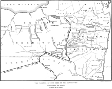
The section of the line east from Owego is also troublesome, because of the faulty geographic references of the negotiators.
The line was to follow a straight line from Owego east to the Delaware River and upriver to a point due south of the confluence of the Unadilla River and east branch of the Susquehanna River just west of Sidney, New York
Sidney, New York
Sidney in the U.S. state of New York may refer to a town in Delaware County, or the village contained in the town.*Sidney , New York*Sidney , New York...
. Apparently the surveys of the day were too poor to realize that
a line due east from Owego at the Owego Creek/Susquehanna confluence (at 42° 05' 41"N) would not have intersected the Delaware River before reaching the line directly south from the mouth of the Unadilla. The sketch map of 1768 places the Delaware much too far north, and shows the projected east-west line intersecting it below the confluence of the East Branch at Hancock
Hancock (village), New York
Hancock is a village in Delaware County, New York, United States. The population was 1,189 at the 2000 census.The Village of Hancock is in the west part of the Town of Hancock at the junction of NY Routes 17 and 97....
, which is actually considerably to the south of the latitude of Owego. Thus at some point the line was adjusted to the Oquaga Creek/Delaware River confluence (at 42° 03' 27"N)
at Deposit, New York
Deposit, New York
Deposit, New York may refer to:*Deposit , New York, in Delaware County*Deposit , New York, located partly within the town to the north and partly in Broome County...
, which forms a natural corner point at the big bend in the West Branch of the Delaware. It is probable that this portion of the line was never surveyed before the Revolution, but instead a north-south line (present-day boundary between the towns of Tioga and Owego in Tioga County, New York
Tioga County, New York
As of the census of 2010, there were 51,125 people residing in the county, with 22,203 housing units, of these 20,350 occupied, 1,853 vacant. The population density was 98 people per square mile...
) was dropped from Owego to the New York - Pennsylvania Border
New York - Pennsylvania Border
The New York–Pennsylvania border is the state line between the U.S. states of New York and Pennsylvania. It has three sections:* along the center line of the Delaware River from the tri-point with New Jersey at the confluence of the Delaware with the Neversink River in Port Jervis, New York to the...
near the 42nd parallel north
42nd parallel north
The 42nd parallel north is a circle of latitude that is 42 degrees north of the Earth's equatorial plane. It crosses Europe, the Mediterranean Sea, Asia, the Pacific Ocean, North America, and the Atlantic Ocean....
sometime after this border was surveyed in 1786, and the Delaware River was followed a few miles upstream (north) from the initial monument of this border near the 42nd parallel north to reach Deposit.
The line to the mouth of the Unadilla was then drawn straight from Deposit, a bit east of north. This is the modern-day boundary between Broome County, New York
Broome County, New York
Broome County is a county located in the U.S. state of New York. As of the 2010 census, the population was 200,600. It was named in honor of John Broome, who was lieutenant governor in 1806 when Broome County was established. Its county seat is Binghamton, which is also its major city. The current...
and Chenango County, New York
Chenango County, New York
Chenango County is a county located in the U.S. state of New York. As of the 2010 census, the population was 50,477. The county's name originates from an Oneida word meaning "large bull-thistle." Its county seat is Norwich.-History:...
(west or Indian side) and Delaware County, New York
Delaware County, New York
Delaware County is a county located in the U.S. state of New York. As of 2010 the population was 47,980. The county seat is Delhi. It is named after the Delaware River, which was named in honor of Thomas West, 3rd Baron De La Warr, appointed governor of Virginia in 1609.-History:When counties...
(east or Colonial side).
The Unadilla River then forms the modern-day boundary between Chenango County, New York (west) and Otsego County, New York (east); the "west branch of the Tianaderha" referred to is not the modern West Branch of the Unadilla that rises near Bridgewater, New York
Bridgewater, New York
Bridgewater is the name of both a town in New York State and a village within that town:*Bridgewater , New York*Bridgewater , New York....
, but rather Beaver Creek a few miles to the west that flows through Brookfield, New York
Brookfield, New York
Brookfield is a town in Madison County, New York, United States. The population was 2,403 at the 2000 census.The Town of Brookfield is located in the southeast part of the county...
to join the Unadilla near New Berlin, New York; Beaver Creek rises at approximately 42° 55' 11" N, 75° 19' 01" W) near Hobin Corners on US 20.
The line then strikes out in a NW direction towards the named confluence (43° 13' 33" N, 75° 32' 39" W) west of present-day Rome, New York, near East Verona, New York. This is a few miles west of Rome, so that Fort Stanwix fell in lands assigned to the Colonials.
The line as finally surveyed went through the Hamilton College campus on College Hill just west of Clinton, New York
Clinton, Oneida County, New York
Clinton is a village in Oneida County, New York, United States. The population was 1,952 at the 2000 census. It was named for George Clinton, a royal governor of the colony of New York....
where there are two stone markers.
Consequences
The first clause effectively cedes most of modern-day Kentucky and West Virginia to the Virginia colonyColony and Dominion of Virginia
The Colony of Virginia was the English colony in North America that existed briefly during the 16th century, and then continuously from 1607 until the American Revolution...
.
This line substantially enlarged the Colonial area designated in the Royal Proclamation of 1763
Royal Proclamation of 1763
The Royal Proclamation of 1763 was issued October 7, 1763, by King George III following Great Britain's acquisition of French territory in North America after the end of the French and Indian War/Seven Years' War...
, especially in Pennsylvania. It also included a slice of New York State east of the Unadilla and west of the previous line of settlement near Cherry Valley. Thus the Iroquois
Iroquois
The Iroquois , also known as the Haudenosaunee or the "People of the Longhouse", are an association of several tribes of indigenous people of North America...
ceded only a small area in New York state, a larger area in Pennsylvania, and a huge tract that was in fact south of their area of control.
Maps
 |
 |
 |
External links
- Tri-Counties Genealogy & History page, includes text of treaty
- 1769 map from A Documentary History of the State of New York Vol. I, by E. B. O'Callaghan (cited in References, above)
- Historical Maps of Pennsylvania, 1765–1769
- History of Lycoming County, Pennsylvania
- Photograph of boundary stone at Hamilton College
- The Old New York Frontier, by Francis Whiting Halsey; New York; Charles Scribner's Sons, 1901 (Part 3, Chapter 2 The Fort Stanwix Deed, and Patents that Followed It (1768–1770), pp. 99–105)