
.gif)
Interstate 190 (New York)
Encyclopedia
Interstate 190 runs 28.34 miles (45.61 km) from Interstate 90
near Buffalo, New York
to Lewiston, New York
via Niagara Falls
. Parts of this highway were built on the former rights-of-way of the Lehigh Valley Railroad
and the Erie Canal
. It is referred to by locals as The One-Ninety. Officially, I-190 from I-90 north to NY 384
is named the Niagara Thruway and is part of the New York State Thruway
system. The remainder, from NY 384 to Lewiston, is known as the Niagara Expressway (maintained by the New York State Department of Transportation
).
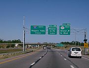
I-190 is the only three-digit Interstate Highway to reach the Canada – United States border. Upon reaching Lewiston, it continues across the Lewiston-Queenston Bridge
over the Niagara River
and into the Canadian
province of Ontario
as Highway 405, a short freeway spur to the Queen Elizabeth Way
(QEW). I-190 also has an interchange in Buffalo leading to the Peace Bridge
, which also crosses the Niagara River into Canada and continues as the QEW on the Canadian side.
 I-190 begins at an interchange with the New York State Thruway
(Interstate 90) in Cheektowaga in Erie County
, just north of the West Seneca
town line and east of the Buffalo
city line. I-190 heads west into Buffalo, passing the former location of the City Line toll barrier ahead of an interchange with South Ogden Street (exit 1). Farther west, I-190 meets NY 354
(exit 2), NY 16
(exit 3), and several local streets before entering downtown Buffalo. Within the downtown area, I-190 passes between First Niagara Center and Coca-Cola Field near an interchange with NY 5
(exit 7) on the shores of Lake Erie
. At NY 5, I-190 turns northward to follow the path of the Niagara River
. Shortly after meeting NY 266
(exit 8) immediately northwest of downtown, I-190 interchanges with Porter Avenue (exit 9), a local roadway connecting I-190 to the Peace Bridge
and, thus, the Queen Elizabeth Way
in Canada
.
North of downtown Buffalo, I-190 follows the eastern edge of the Black Rock Canal (and passes the site of the former Black Rock toll barrier) before rejoining the banks of the Niagara near an exit with the Scajaquada Expressway (NY 198
, exit 11). I-190 continues north through the northern extents of Buffalo, meeting multiple streets before separating from the Niagara and interchanging with NY 266
and NY 324
(exits 15 and 16) in quick succession. At exit 16, NY 324 joins I-190 northward through western Tonawanda
. The two routes then meet Interstate 290
and NY 266 a second time prior to crossing the Niagara River on the South Grand Island Bridge
. NY 324 leaves the expressway shortly after arriving on Grand Island
at exit 18.
 NY 324 and I-190 follow parallel routings across Grand Island, with both roads passing on opposite sides of Martin's Fantasy Island
, a local amusement park, near the center of the island. At the northern edge of the island, NY 324, as signed, terminates at exit 20; however, officially, NY 324 rejoins I-190 across the Niagara River once again via the North Grand Island Bridge
. Now in Niagara Falls
, Niagara County
, NY 324 ends at a complex interchange featuring NY 384
, the Robert Moses State Parkway
, and the LaSalle Expressway
on the eastern bank of the river. Farther north, I-190 meets U.S. Route 62 (exit 22) and NY 182
(exit 23).
Past NY 182, I-190 turns to the northwest, skirting the northeastern edge of Niagara Falls and roughly paralleling NY 265
to the east. In Lewiston
, the expressway meets NY 31
at exit 24 southwest of the large Robert Moses Niagara Power Plant reservoir. I-190 continues onward, crossing the canal between the reservoir and the power plant on a small dam also used by NY 265. The freeway then interchanges with NY 265, the Robert Moses Parkway, and NY 104
at the expansive exit 25 before curving to the west and terminating at the approach to the Lewiston-Queenston Bridge
. Across the bridge in Queenston, Ontario
, the roadway becomes Highway 405.
in Niagara Falls
was originally built by the New York State Thruway Authority as part of the New York State Thruway
system. Construction on two segments of the highway—from Church Street to Porter Avenue in downtown Buffalo
and from Beaver Island Parkway to West River Road on Grand Island
—began in the early 1950s. The section in downtown Buffalo was completed by 1954 while the Grand Island portion opened at some point between 1956 and 1958. A short segment of the highway between the Skyway and Church Street was completed around the same time. By 1958, construction had begun on the remainder of the Niagara Thruway. It was completed ca. 1961.
On August 14, 1957, the routing of what is now I-190 (including the then-partially complete Niagara Thruway) was originally designated as Interstate 90N. This is because intercity routes—such as I-90N, which connected Buffalo
to Canada
via Niagara Falls
—were numbered before the three-digit Interstates were assigned to the shorter intracity routes. I-90N was renumbered to I-190 on February 24, 1959. Construction on the portion of I-190 north of NY 384 began ca. 1962 and was completed by 1964.
In 1991, maintenance of I-84
in downstate New York was transferred from the New York State Department of Transportation
(NYSDOT) to the New York State Thruway Authority (NYSTA). The monies for that purpose came from tolls levied on I-190 in downtown Buffalo
. Under the laws authorizing the thruway construction, the tolls were to be removed once the original bonds used to pay for the construction were paid off, which occurred in 1996; however, the tolls would remain for ten more years. Attorney Carl Paladino
brought a lawsuit against the state in 2006 to force the removal of the tolls. On October 30, 2006, the Thruway Authority voted to both begin the process of returning maintenance of I-84 to NYSDOT and to remove the tolls on I-190 in Buffalo. Collection of the tolls stopped that day. Both major candidates in the 2006 New York gubernatorial election
, Democrat Eliot Spitzer
and Republican John Faso
, had pledged to remove the tolls on I-190 if elected. While the toll barriers in Buffalo have since been demolished, the tolls further north on the Grand Island bridges still remain.
|rowspan=31|Erie
|Cheektowaga
|0.00
|
|
|Southbound exit and northbound entrance
|-
|rowspan=17|Buffalo
|0.70
|1
|South Ogden Street
|
|-
|1.56
|2
|
|
|-
|2.22
|3
|
|Southbound exit and northbound entrance
|-
|3.14
|4
|Smith Street / Fillmore Avenue
|
|-
|3.79
|rowspan=2|5
|Hamburg Street
|Northbound exit and entrance
|-
|4.13
|Louisiana Street
|Southbound exit and entrance
|-
|4.99
|6
|Elm Street
|
|-
|5.10
|rowspan=2|7
|
|No northbound exit
|-
|5.20
|Church Street
|No southbound exit
|-
|5.86
|8
|
|
|-
|6.58
|9
|Porter Avenue – Peace Bridge
, Fort Erie
, Canada
|To Queen Elizabeth Way
and Highway 3
|-
|7.78
|10
|West Ferry Street
|Exit was part of the original design but never constructed
|-
|8.69
|11
|
|Western terminus of NY 198
|-
|9.18
|12
|Amherst Street
|Northbound exit and southbound entrance
|-
|9.44
|13
|Austin Street
|Northbound exit and southbound entrance
|-
|9.88
|rowspan=2|14
|Ontario Street
|Southbound exit and northbound entrance
|-
|10.50
|Vulcan Street
|Northbound exit and southbound entrance
|-
|rowspan=5|Tonawanda
|12.36
|15
|/ Kenmore Avenue
|NY 324 joins northbound and leaves southbound; northbound access via NY 325
|-
|13.33
|16
|
|
|-
|14.20
|17
|
|North Tonawanda and Tonawanda shown as "Tonawandas" on guide signs
|-
|14.26
|colspan=3 align="center"|Tonawanda
toll barrier ($1.00 cash or 95¢ E-ZPass
northbound)
|-
|rowspan=2 colspan=4 align="center"|South Grand Island Bridge
over the Niagara River
|-
|rowspan=8|Grand Island
|-
|15.35
|18A
|
|Northbound exit and southbound entrance; NY 324 leaves northbound and joins southbound
|-
|15.46
|18B
|Beaver Island State Park
|Exit 18 southbound
|-
|17.27
|19
|Whitehaven Road
|
|-
|19.32
|20B
|
|Exit 20 northbound; NY 324 joins northbound and leaves southbound
|-
|19.69
|20A
|West River Parkway
|No northbound exit
|-
|20.22
|colspan=3 align="center"|Niagara
toll barrier ($1.00 cash or 95¢ E-ZPass southbound)
|-
|rowspan=2 colspan=4 align="center"|North Grand Island Bridge
over the Niagara River
|-
|rowspan=10|Niagara
|rowspan=5|Niagara Falls
|-
|21.10
21.20
|21
|
|NY 324 terminates northbound and joins I-190 southbound
|-
|21.24
|colspan=3 align="center"|Begin Niagara Expressway (NYSDOT maintenance) northbound; begin Niagara Thruway (NYSTA maintenance) southbound
|-
|
|21A
|
|North Tonawanda and Tonawanda shown as "Tonawandas" on guide signs
|-
|22.08
|22
|
|
|-
|rowspan="2"|Niagara
|23.74
|23
|
|
|-
|25.87
|24
|
|
|-
|rowspan="3"|Lewiston
|rowspan="2"|27.72
|25A
|
|No southbound exit
|-
|25B
|
|
|-
|28.34
|colspan=3 align="center"|Lewiston-Queenston Bridge
over the Niagara River
(United States-Canada border); I-190 becomes Highway 405 in Ontario
Interstate 90 in New York
Interstate 90 is a part of the Interstate Highway System that runs from Seattle, Washington, to Boston, Massachusetts. In the U.S. state of New York, I-90 extends from the Pennsylvania state line at Ripley to the Massachusetts state line at Canaan...
near Buffalo, New York
Buffalo, New York
Buffalo is the second most populous city in the state of New York, after New York City. Located in Western New York on the eastern shores of Lake Erie and at the head of the Niagara River across from Fort Erie, Ontario, Buffalo is the seat of Erie County and the principal city of the...
to Lewiston, New York
Lewiston, New York
Lewiston is a village in Niagara County, New York, United States. The population was 2,781 at the 2000 census. The village is named after Morgan Lewis, an early 19th-century governor of New York. It is part of the Buffalo–Niagara Falls Metropolitan Statistical Area.The Village of Lewiston,...
via Niagara Falls
Niagara Falls
The Niagara Falls, located on the Niagara River draining Lake Erie into Lake Ontario, is the collective name for the Horseshoe Falls and the adjacent American Falls along with the comparatively small Bridal Veil Falls, which combined form the highest flow rate of any waterfalls in the world and has...
. Parts of this highway were built on the former rights-of-way of the Lehigh Valley Railroad
Lehigh Valley Railroad
The Lehigh Valley Railroad was one of a number of railroads built in the northeastern United States primarily to haul anthracite coal.It was authorized April 21, 1846 in the U.S. state of Pennsylvania and incorporated September 20, 1847 as the Delaware, Lehigh, Schuylkill and Susquehanna Railroad...
and the Erie Canal
Erie Canal
The Erie Canal is a waterway in New York that runs about from Albany, New York, on the Hudson River to Buffalo, New York, at Lake Erie, completing a navigable water route from the Atlantic Ocean to the Great Lakes. The canal contains 36 locks and encompasses a total elevation differential of...
. It is referred to by locals as The One-Ninety. Officially, I-190 from I-90 north to NY 384
New York State Route 384
New York State Route 384 is a state highway in Western New York in the United States. It is a north–south route extending from the city of Buffalo, Erie County to the city of Niagara Falls, Niagara County, and is one of several routes directly connecting the two cities. The southern terminus...
is named the Niagara Thruway and is part of the New York State Thruway
New York State Thruway
The New York State Thruway is a system of limited-access highways located within the state of New York in the United States. The system, known officially as the Governor Thomas E. Dewey Thruway for former New York Governor Thomas E. Dewey, is operated by the New York State Thruway Authority and...
system. The remainder, from NY 384 to Lewiston, is known as the Niagara Expressway (maintained by the New York State Department of Transportation
New York State Department of Transportation
The New York State Department of Transportation is responsible for the development and operation of highways, railroads, mass transit systems, ports, waterways and aviation facilities in the U.S...
).
I-190 is the only three-digit Interstate Highway to reach the Canada – United States border. Upon reaching Lewiston, it continues across the Lewiston-Queenston Bridge
Lewiston-Queenston Bridge
The Lewiston–Queenston Bridge is an arch bridge that crosses the Niagara River gorge just south of the Niagara Escarpment. The bridge was officially opened on November 1, 1962. It is an international bridge between the United States and Canada. It connects Interstate 190 in the town of Lewiston,...
over the Niagara River
Niagara River
The Niagara River flows north from Lake Erie to Lake Ontario. It forms part of the border between the Province of Ontario in Canada and New York State in the United States. There are differing theories as to the origin of the name of the river...
and into the Canadian
Canada
Canada is a North American country consisting of ten provinces and three territories. Located in the northern part of the continent, it extends from the Atlantic Ocean in the east to the Pacific Ocean in the west, and northward into the Arctic Ocean...
province of Ontario
Ontario
Ontario is a province of Canada, located in east-central Canada. It is Canada's most populous province and second largest in total area. It is home to the nation's most populous city, Toronto, and the nation's capital, Ottawa....
as Highway 405, a short freeway spur to the Queen Elizabeth Way
Queen Elizabeth Way
The Queen Elizabeth Way, commonly abbreviated as the QEW, is a 400-Series highway in the Canadian province of Ontario. The freeway links Buffalo, New York and the Niagara Peninsula with Toronto. It begins at the Peace Bridge in Fort Erie and travels around the western shore of Lake Ontario, ending...
(QEW). I-190 also has an interchange in Buffalo leading to the Peace Bridge
Peace Bridge
The Peace Bridge is an international bridge between Canada and the United States at the east end of Lake Erie at the source of the Niagara River, about upriver of Niagara Falls. It connects the City of Buffalo, New York, in the United States to the Town of Fort Erie, Ontario, in Canada...
, which also crosses the Niagara River into Canada and continues as the QEW on the Canadian side.
Route description
New York State Thruway
The New York State Thruway is a system of limited-access highways located within the state of New York in the United States. The system, known officially as the Governor Thomas E. Dewey Thruway for former New York Governor Thomas E. Dewey, is operated by the New York State Thruway Authority and...
(Interstate 90) in Cheektowaga in Erie County
Erie County, New York
Erie County is a county located in the U.S. state of New York. As of the 2010 census, the population was 919,040. The county seat is Buffalo. The county's name comes from Lake Erie, which in turn comes from the Erie tribe of American Indians who lived south and east of the lake before 1654.Erie...
, just north of the West Seneca
West Seneca, New York
West Seneca is a town in Erie County, New York, United States. The population was 44,711 at the 2010 census. West Seneca is a centrally-located interior town of the county, and a suburb of Buffalo...
town line and east of the Buffalo
Buffalo, New York
Buffalo is the second most populous city in the state of New York, after New York City. Located in Western New York on the eastern shores of Lake Erie and at the head of the Niagara River across from Fort Erie, Ontario, Buffalo is the seat of Erie County and the principal city of the...
city line. I-190 heads west into Buffalo, passing the former location of the City Line toll barrier ahead of an interchange with South Ogden Street (exit 1). Farther west, I-190 meets NY 354
New York State Route 354
New York State Route 354 is a state highway in New York, USA. NY 354 is one of several highways radiating eastward from its western terminus in downtown Buffalo, New York. The east terminus of NY 354 is in the Village of Attica, where it ends at NY 98 and NY 238 as West...
(exit 2), NY 16
New York State Route 16
New York State Route 16 is a state highway in western New York, United States. It runs from the Pennsylvania state line, where it is one of the highest highways in the state in elevation, to downtown Buffalo. NY 16 is a major route through Erie County, despite the construction of the...
(exit 3), and several local streets before entering downtown Buffalo. Within the downtown area, I-190 passes between First Niagara Center and Coca-Cola Field near an interchange with NY 5
New York State Route 5
New York State Route 5 is a state highway that extends for across the state of New York in the United States. It begins at the Pennsylvania state line in the Chautauqua County town of Ripley and passes through Buffalo, Syracuse, Utica, Schenectady, and several other smaller cities and...
(exit 7) on the shores of Lake Erie
Lake Erie
Lake Erie is the fourth largest lake of the five Great Lakes in North America, and the tenth largest globally. It is the southernmost, shallowest, and smallest by volume of the Great Lakes and therefore also has the shortest average water residence time. It is bounded on the north by the...
. At NY 5, I-190 turns northward to follow the path of the Niagara River
Niagara River
The Niagara River flows north from Lake Erie to Lake Ontario. It forms part of the border between the Province of Ontario in Canada and New York State in the United States. There are differing theories as to the origin of the name of the river...
. Shortly after meeting NY 266
New York State Route 266
New York State Route 266 is a state highway in Erie County, New York, in the United States. It runs along the Niagara River from the city of Buffalo to the city of North Tonawanda. The southern terminus of the route is at the ramps leading to Interstate 190 exit 8 in Buffalo...
(exit 8) immediately northwest of downtown, I-190 interchanges with Porter Avenue (exit 9), a local roadway connecting I-190 to the Peace Bridge
Peace Bridge
The Peace Bridge is an international bridge between Canada and the United States at the east end of Lake Erie at the source of the Niagara River, about upriver of Niagara Falls. It connects the City of Buffalo, New York, in the United States to the Town of Fort Erie, Ontario, in Canada...
and, thus, the Queen Elizabeth Way
Queen Elizabeth Way
The Queen Elizabeth Way, commonly abbreviated as the QEW, is a 400-Series highway in the Canadian province of Ontario. The freeway links Buffalo, New York and the Niagara Peninsula with Toronto. It begins at the Peace Bridge in Fort Erie and travels around the western shore of Lake Ontario, ending...
in Canada
Canada
Canada is a North American country consisting of ten provinces and three territories. Located in the northern part of the continent, it extends from the Atlantic Ocean in the east to the Pacific Ocean in the west, and northward into the Arctic Ocean...
.
North of downtown Buffalo, I-190 follows the eastern edge of the Black Rock Canal (and passes the site of the former Black Rock toll barrier) before rejoining the banks of the Niagara near an exit with the Scajaquada Expressway (NY 198
New York State Route 198
New York State Route 198 is a state highway located entirely within the city of Buffalo, New York, in the United States. It is named the Scajaquada Expressway for Scajaquada Creek, which it parallels as it heads across northern Buffalo...
, exit 11). I-190 continues north through the northern extents of Buffalo, meeting multiple streets before separating from the Niagara and interchanging with NY 266
New York State Route 266
New York State Route 266 is a state highway in Erie County, New York, in the United States. It runs along the Niagara River from the city of Buffalo to the city of North Tonawanda. The southern terminus of the route is at the ramps leading to Interstate 190 exit 8 in Buffalo...
and NY 324
New York State Route 324
New York State Route 324 is an east–west state highway located in the western portion of New York in the United States...
(exits 15 and 16) in quick succession. At exit 16, NY 324 joins I-190 northward through western Tonawanda
Tonawanda (town), New York
Tonawanda is a town in Erie County, New York, United States. As of the 2000 census, the town had a population of 78,155. The town is at the north border of the county and is the northern suburb of Buffalo...
. The two routes then meet Interstate 290
Interstate 290 (New York)
Interstate 290 runs for near Buffalo, New York from I-90 to I-190. It connects Buffalo with its northern suburbs of Amherst and Tonawanda, and provides a route to Niagara Falls that bypasses the city of Buffalo. I-290 also connects to Interstate 990, and through this connection,...
and NY 266 a second time prior to crossing the Niagara River on the South Grand Island Bridge
South Grand Island Bridge
The South Grand Island Bridge carries Interstate 190 across the Niagara River between Tonawanda, New York and Grand Island, New York. The toll plaza is found on the Tonawanda side of the bridge; Only 2 booths are EZ-Pass, the remainder are manned booths.The twin Truss arch bridges crosses from...
. NY 324 leaves the expressway shortly after arriving on Grand Island
Grand Island, New York
Grand Island is a town and an island in Erie County, New York, USA. As of the 2010 census, the town population is 20,374. This represents an increase of 9.41% from the 2000 census figure . The current town name derives from the French name La Grande Île, as Grand Island is the largest island in...
at exit 18.
Martin's Fantasy Island
Martin's Fantasy Island is an amusement park located in Grand Island, New York.- History :Fantasy Island opened in 1961 and went bankrupt in 1982. It was acquired out of bankruptcy by Charles Wood, the original owner of Storytown USA. He sold the park to International Broadcasting Corporation in...
, a local amusement park, near the center of the island. At the northern edge of the island, NY 324, as signed, terminates at exit 20; however, officially, NY 324 rejoins I-190 across the Niagara River once again via the North Grand Island Bridge
North Grand Island Bridge
The North Grand Island Bridge carries Interstate 190 across the Niagara River between Grand Island, New York and Niagara Falls, New York. The toll plaza are found on the Grand Island, New York side of the bridge....
. Now in Niagara Falls
Niagara Falls, New York
Niagara Falls is a city in Niagara County, New York, United States. As of the 2010 census, the city had a total population of 50,193, down from the 55,593 recorded in the 2000 census. It is across the Niagara River from Niagara Falls, Ontario , both named after the famed Niagara Falls which they...
, Niagara County
Niagara County, New York
Niagara County is a county located in the U.S. state of New York. As of the 2010 census, the population was 216,469. The county seat is Lockport. The county name is from the Iroquois word Onguiaahra; meaning the strait or thunder of waters. It is the location of Niagara Falls and Fort Niagara, and...
, NY 324 ends at a complex interchange featuring NY 384
New York State Route 384
New York State Route 384 is a state highway in Western New York in the United States. It is a north–south route extending from the city of Buffalo, Erie County to the city of Niagara Falls, Niagara County, and is one of several routes directly connecting the two cities. The southern terminus...
, the Robert Moses State Parkway
Robert Moses State Parkway
The Robert Moses State Parkway is an long north–south highway in western Niagara County, New York, United States. Its southern terminus is at the LaSalle Expressway on the east bank of the Niagara River in Niagara Falls. The northern terminus is at NY 18 at Four Mile Creek State Park in...
, and the LaSalle Expressway
LaSalle Expressway
The LaSalle Expressway is a long limited-access highway in Niagara County, New York, United States. It begins near the North Grand Island Bridge at an interchange with Interstate 190 in Niagara Falls and ends just south of the Niagara Falls International Airport at Williams Road in Wheatfield...
on the eastern bank of the river. Farther north, I-190 meets U.S. Route 62 (exit 22) and NY 182
New York State Route 182
New York State Route 182 is a state highway in Niagara County, New York, United States. It serves as a signed connection between the Whirlpool Rapids Bridge over the Niagara River and the Niagara Falls International Airport east of the city of Niagara Falls...
(exit 23).
Past NY 182, I-190 turns to the northwest, skirting the northeastern edge of Niagara Falls and roughly paralleling NY 265
New York State Route 265
New York State Route 265 is a state highway located in the western part of New York in the United States. NY 265 is a north–south route that roughly parallels the western parts of the Niagara River in Erie County and Niagara County...
to the east. In Lewiston
Lewiston (town), New York
Lewiston is a town in Niagara County, New York United States. The population was 16,262 at the 2010 census. The town and its contained village are named after Morgan Lewis, a governor of New York....
, the expressway meets NY 31
New York State Route 31
New York State Route 31 is a state highway that extends for across western and central New York in the United States. The western terminus of the route is at an intersection with NY 104 in the city of Niagara Falls. Its eastern terminus is at a traffic circle with NY 26 in Vernon...
at exit 24 southwest of the large Robert Moses Niagara Power Plant reservoir. I-190 continues onward, crossing the canal between the reservoir and the power plant on a small dam also used by NY 265. The freeway then interchanges with NY 265, the Robert Moses Parkway, and NY 104
New York State Route 104
New York State Route 104 is a long east–west state highway in Upstate New York, United States. It spans six counties and enters the vicinity of four cities—Niagara Falls, Lockport, Rochester, and Oswego—as it follows a routing largely parallel to that of the southern shoreline of Lake...
at the expansive exit 25 before curving to the west and terminating at the approach to the Lewiston-Queenston Bridge
Lewiston-Queenston Bridge
The Lewiston–Queenston Bridge is an arch bridge that crosses the Niagara River gorge just south of the Niagara Escarpment. The bridge was officially opened on November 1, 1962. It is an international bridge between the United States and Canada. It connects Interstate 190 in the town of Lewiston,...
. Across the bridge in Queenston, Ontario
Queenston, Ontario
Queenston is located 5 km north of Niagara Falls, Ontario in the Town of Niagara-on-the-Lake. The community is bordered by Highway 405 and the Niagara River; its location on the Niagara Escarpment led to the establishment of the now-defunct Queenston Quarry in the area...
, the roadway becomes Highway 405.
History
The portion of modern I-190 south of NY 384New York State Route 384
New York State Route 384 is a state highway in Western New York in the United States. It is a north–south route extending from the city of Buffalo, Erie County to the city of Niagara Falls, Niagara County, and is one of several routes directly connecting the two cities. The southern terminus...
in Niagara Falls
Niagara Falls, New York
Niagara Falls is a city in Niagara County, New York, United States. As of the 2010 census, the city had a total population of 50,193, down from the 55,593 recorded in the 2000 census. It is across the Niagara River from Niagara Falls, Ontario , both named after the famed Niagara Falls which they...
was originally built by the New York State Thruway Authority as part of the New York State Thruway
New York State Thruway
The New York State Thruway is a system of limited-access highways located within the state of New York in the United States. The system, known officially as the Governor Thomas E. Dewey Thruway for former New York Governor Thomas E. Dewey, is operated by the New York State Thruway Authority and...
system. Construction on two segments of the highway—from Church Street to Porter Avenue in downtown Buffalo
Buffalo, New York
Buffalo is the second most populous city in the state of New York, after New York City. Located in Western New York on the eastern shores of Lake Erie and at the head of the Niagara River across from Fort Erie, Ontario, Buffalo is the seat of Erie County and the principal city of the...
and from Beaver Island Parkway to West River Road on Grand Island
Grand Island, New York
Grand Island is a town and an island in Erie County, New York, USA. As of the 2010 census, the town population is 20,374. This represents an increase of 9.41% from the 2000 census figure . The current town name derives from the French name La Grande Île, as Grand Island is the largest island in...
—began in the early 1950s. The section in downtown Buffalo was completed by 1954 while the Grand Island portion opened at some point between 1956 and 1958. A short segment of the highway between the Skyway and Church Street was completed around the same time. By 1958, construction had begun on the remainder of the Niagara Thruway. It was completed ca. 1961.
On August 14, 1957, the routing of what is now I-190 (including the then-partially complete Niagara Thruway) was originally designated as Interstate 90N. This is because intercity routes—such as I-90N, which connected Buffalo
Buffalo, New York
Buffalo is the second most populous city in the state of New York, after New York City. Located in Western New York on the eastern shores of Lake Erie and at the head of the Niagara River across from Fort Erie, Ontario, Buffalo is the seat of Erie County and the principal city of the...
to Canada
Canada
Canada is a North American country consisting of ten provinces and three territories. Located in the northern part of the continent, it extends from the Atlantic Ocean in the east to the Pacific Ocean in the west, and northward into the Arctic Ocean...
via Niagara Falls
Niagara Falls, New York
Niagara Falls is a city in Niagara County, New York, United States. As of the 2010 census, the city had a total population of 50,193, down from the 55,593 recorded in the 2000 census. It is across the Niagara River from Niagara Falls, Ontario , both named after the famed Niagara Falls which they...
—were numbered before the three-digit Interstates were assigned to the shorter intracity routes. I-90N was renumbered to I-190 on February 24, 1959. Construction on the portion of I-190 north of NY 384 began ca. 1962 and was completed by 1964.
In 1991, maintenance of I-84
Interstate 84 (east)
Interstate 84 is an Interstate Highway extending from Dunmore, Pennsylvania at an interchange with Interstate 81 to Sturbridge, Massachusetts, at an interchange with the Massachusetts Turnpike . I-84 has mile-log junction numbering in Pennsylvania; otherwise, exit numbers are roughly sequential...
in downstate New York was transferred from the New York State Department of Transportation
New York State Department of Transportation
The New York State Department of Transportation is responsible for the development and operation of highways, railroads, mass transit systems, ports, waterways and aviation facilities in the U.S...
(NYSDOT) to the New York State Thruway Authority (NYSTA). The monies for that purpose came from tolls levied on I-190 in downtown Buffalo
Buffalo, New York
Buffalo is the second most populous city in the state of New York, after New York City. Located in Western New York on the eastern shores of Lake Erie and at the head of the Niagara River across from Fort Erie, Ontario, Buffalo is the seat of Erie County and the principal city of the...
. Under the laws authorizing the thruway construction, the tolls were to be removed once the original bonds used to pay for the construction were paid off, which occurred in 1996; however, the tolls would remain for ten more years. Attorney Carl Paladino
Carl Paladino
Carl Pasquale Paladino is an American businessman and political activist from Buffalo, New York. Paladino is the founder and chairman of Ellicott Development Company, a real estate development company he founded in 1973. He was the 2010 Republican nominee for the New York gubernatorial election,...
brought a lawsuit against the state in 2006 to force the removal of the tolls. On October 30, 2006, the Thruway Authority voted to both begin the process of returning maintenance of I-84 to NYSDOT and to remove the tolls on I-190 in Buffalo. Collection of the tolls stopped that day. Both major candidates in the 2006 New York gubernatorial election
New York gubernatorial election, 2006
The New York gubernatorial election of 2006 was a race for the governorship of this U.S. state. Eliot Spitzer was elected on November 7, 2006, succeeding Governor George Pataki, the three-term incumbent, who did not run for a fourth term....
, Democrat Eliot Spitzer
Eliot Spitzer
Eliot Laurence Spitzer is an American lawyer, former Democratic Party politician, and political commentator. He was the co-host of In the Arena, a talk-show and punditry forum broadcast on CNN until CNN cancelled his show in July of 2011...
and Republican John Faso
John Faso
John Faso was the Republican nominee for Governor of New York in 2006, and was defeated by Democratic nominee Eliot Spitzer in the largest defeat for a Republican gubernatorial candidate in the state's history. This followed his loss to Alan Hevesi four years earlier in his run for State Comptroller...
, had pledged to remove the tolls on I-190 if elected. While the toll barriers in Buffalo have since been demolished, the tolls further north on the Grand Island bridges still remain.
Exit list
|-|rowspan=31|Erie
Erie County, New York
Erie County is a county located in the U.S. state of New York. As of the 2010 census, the population was 919,040. The county seat is Buffalo. The county's name comes from Lake Erie, which in turn comes from the Erie tribe of American Indians who lived south and east of the lake before 1654.Erie...
|Cheektowaga
|0.00
|
|
|Southbound exit and northbound entrance
|-
|rowspan=17|Buffalo
Buffalo, New York
Buffalo is the second most populous city in the state of New York, after New York City. Located in Western New York on the eastern shores of Lake Erie and at the head of the Niagara River across from Fort Erie, Ontario, Buffalo is the seat of Erie County and the principal city of the...
|0.70
|1
|South Ogden Street
|
|-
|1.56
|2
|
|
|-
|2.22
|3
|
|Southbound exit and northbound entrance
|-
|3.14
|4
|Smith Street / Fillmore Avenue
|
|-
|3.79
|rowspan=2|5
|Hamburg Street
|Northbound exit and entrance
|-
|4.13
|Louisiana Street
|Southbound exit and entrance
|-
|4.99
|6
|Elm Street
|
|-
|5.10
|rowspan=2|7
|
|No northbound exit
|-
|5.20
|Church Street
|No southbound exit
|-
|5.86
|8
|
|
|-
|6.58
|9
|Porter Avenue – Peace Bridge
Peace Bridge
The Peace Bridge is an international bridge between Canada and the United States at the east end of Lake Erie at the source of the Niagara River, about upriver of Niagara Falls. It connects the City of Buffalo, New York, in the United States to the Town of Fort Erie, Ontario, in Canada...
, Fort Erie
Fort Erie, Ontario
Fort Erie is a town on the Niagara River in the Niagara Region, Ontario, Canada. It is located directly across the river from Buffalo, New York....
, Canada
Canada
Canada is a North American country consisting of ten provinces and three territories. Located in the northern part of the continent, it extends from the Atlantic Ocean in the east to the Pacific Ocean in the west, and northward into the Arctic Ocean...
|To Queen Elizabeth Way
Queen Elizabeth Way
The Queen Elizabeth Way, commonly abbreviated as the QEW, is a 400-Series highway in the Canadian province of Ontario. The freeway links Buffalo, New York and the Niagara Peninsula with Toronto. It begins at the Peace Bridge in Fort Erie and travels around the western shore of Lake Ontario, ending...
and Highway 3
Highway 3 (Ontario)
King's Highway 3, commonly referred to as Highway 3 and historically as the Talbot Trail, is a provincially maintained highway in the Canadian province of Ontario which travels parallel to the shore of Lake Erie. It has three segments, the first of which runs from the Ambassador Bridge in Windsor...
|-
|7.78
|10
|West Ferry Street
|Exit was part of the original design but never constructed
|-
|8.69
|11
|
|Western terminus of NY 198
|-
|9.18
|12
|Amherst Street
|Northbound exit and southbound entrance
|-
|9.44
|13
|Austin Street
|Northbound exit and southbound entrance
|-
|9.88
|rowspan=2|14
|Ontario Street
|Southbound exit and northbound entrance
|-
|10.50
|Vulcan Street
|Northbound exit and southbound entrance
|-
|rowspan=5|Tonawanda
Tonawanda (town), New York
Tonawanda is a town in Erie County, New York, United States. As of the 2000 census, the town had a population of 78,155. The town is at the north border of the county and is the northern suburb of Buffalo...
|12.36
|15
|/ Kenmore Avenue
|NY 324 joins northbound and leaves southbound; northbound access via NY 325
|-
|13.33
|16
|
|
|-
|14.20
|17
|
|North Tonawanda and Tonawanda shown as "Tonawandas" on guide signs
|-
|14.26
|colspan=3 align="center"|Tonawanda
Tonawanda (town), New York
Tonawanda is a town in Erie County, New York, United States. As of the 2000 census, the town had a population of 78,155. The town is at the north border of the county and is the northern suburb of Buffalo...
toll barrier ($1.00 cash or 95¢ E-ZPass
E-ZPass
E-ZPass is an electronic toll-collection system used on most tolled roads, bridges, and tunnels in the northeastern US, south to Virginia and West Virginia, and west to Illinois. Currently, there are 25 agencies spread across 14 states that make up the . All member agencies use the same technology,...
northbound)
|-
|rowspan=2 colspan=4 align="center"|South Grand Island Bridge
South Grand Island Bridge
The South Grand Island Bridge carries Interstate 190 across the Niagara River between Tonawanda, New York and Grand Island, New York. The toll plaza is found on the Tonawanda side of the bridge; Only 2 booths are EZ-Pass, the remainder are manned booths.The twin Truss arch bridges crosses from...
over the Niagara River
Niagara River
The Niagara River flows north from Lake Erie to Lake Ontario. It forms part of the border between the Province of Ontario in Canada and New York State in the United States. There are differing theories as to the origin of the name of the river...
|-
|rowspan=8|Grand Island
Grand Island, New York
Grand Island is a town and an island in Erie County, New York, USA. As of the 2010 census, the town population is 20,374. This represents an increase of 9.41% from the 2000 census figure . The current town name derives from the French name La Grande Île, as Grand Island is the largest island in...
|-
|15.35
|18A
|
|Northbound exit and southbound entrance; NY 324 leaves northbound and joins southbound
|-
|15.46
|18B
|Beaver Island State Park
Beaver Island State Park
Beaver Island State Park is a New York state park located in the town of Grand Island in northwestern Erie County, New York. The historic summer home of Lewis Allen, the uncle of US President Grover Cleveland is within the park...
|Exit 18 southbound
|-
|17.27
|19
|Whitehaven Road
|
|-
|19.32
|20B
|
|Exit 20 northbound; NY 324 joins northbound and leaves southbound
|-
|19.69
|20A
|West River Parkway
|No northbound exit
|-
|20.22
|colspan=3 align="center"|Niagara
Niagara Falls, New York
Niagara Falls is a city in Niagara County, New York, United States. As of the 2010 census, the city had a total population of 50,193, down from the 55,593 recorded in the 2000 census. It is across the Niagara River from Niagara Falls, Ontario , both named after the famed Niagara Falls which they...
toll barrier ($1.00 cash or 95¢ E-ZPass southbound)
|-
|rowspan=2 colspan=4 align="center"|North Grand Island Bridge
North Grand Island Bridge
The North Grand Island Bridge carries Interstate 190 across the Niagara River between Grand Island, New York and Niagara Falls, New York. The toll plaza are found on the Grand Island, New York side of the bridge....
over the Niagara River
Niagara River
The Niagara River flows north from Lake Erie to Lake Ontario. It forms part of the border between the Province of Ontario in Canada and New York State in the United States. There are differing theories as to the origin of the name of the river...
|-
|rowspan=10|Niagara
Niagara County, New York
Niagara County is a county located in the U.S. state of New York. As of the 2010 census, the population was 216,469. The county seat is Lockport. The county name is from the Iroquois word Onguiaahra; meaning the strait or thunder of waters. It is the location of Niagara Falls and Fort Niagara, and...
|rowspan=5|Niagara Falls
Niagara Falls, New York
Niagara Falls is a city in Niagara County, New York, United States. As of the 2010 census, the city had a total population of 50,193, down from the 55,593 recorded in the 2000 census. It is across the Niagara River from Niagara Falls, Ontario , both named after the famed Niagara Falls which they...
|-
|21.10
21.20
|21
|
|NY 324 terminates northbound and joins I-190 southbound
|-
|21.24
|colspan=3 align="center"|Begin Niagara Expressway (NYSDOT maintenance) northbound; begin Niagara Thruway (NYSTA maintenance) southbound
|-
|
|21A
|
|North Tonawanda and Tonawanda shown as "Tonawandas" on guide signs
|-
|22.08
|22
|
|
|-
|rowspan="2"|Niagara
Niagara, New York
Niagara is a town in Niagara County, New York, United States. As of the 2010 census, the town had a total population of 8,378. The town is named after the famous waterfall Niagara Falls....
|23.74
|23
|
|
|-
|25.87
|24
|
|
|-
|rowspan="3"|Lewiston
Lewiston (town), New York
Lewiston is a town in Niagara County, New York United States. The population was 16,262 at the 2010 census. The town and its contained village are named after Morgan Lewis, a governor of New York....
|rowspan="2"|27.72
|25A
|
|No southbound exit
|-
|25B
|
|
|-
|28.34
|colspan=3 align="center"|Lewiston-Queenston Bridge
Lewiston-Queenston Bridge
The Lewiston–Queenston Bridge is an arch bridge that crosses the Niagara River gorge just south of the Niagara Escarpment. The bridge was officially opened on November 1, 1962. It is an international bridge between the United States and Canada. It connects Interstate 190 in the town of Lewiston,...
over the Niagara River
Niagara River
The Niagara River flows north from Lake Erie to Lake Ontario. It forms part of the border between the Province of Ontario in Canada and New York State in the United States. There are differing theories as to the origin of the name of the river...
(United States-Canada border); I-190 becomes Highway 405 in Ontario
Ontario
Ontario is a province of Canada, located in east-central Canada. It is Canada's most populous province and second largest in total area. It is home to the nation's most populous city, Toronto, and the nation's capital, Ottawa....