
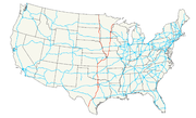
Interstate 35
Encyclopedia
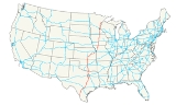
Interstate 35 is a north–south Interstate Highway in the central United States
. I-35 stretches from Laredo
, Texas
, on the U.S.-Mexico border to Duluth
, Minnesota
, at Minnesota Highway 61
(London Road) and 26th Avenue East. Many interstates used to have splits or spurs indicated with suffixed letters (N
/S
/E
/W
), but I-35 is the only one that still has such divisions. In two stretches, both through twin cities, the highway splits into Interstate 35E (Dallas and St. Paul
) and Interstate 35W (Fort Worth
and Minneapolis).
Interstate 35 does not directly connect to either international border. I-35's southern terminus is a traffic signal in Laredo
, Texas
, just short of the United States-Mexico border. Travelers going south can take one of two toll bridges across the Rio Grande
and the Mexican border—straight ahead into Juarez-Lincoln International Bridge
, or via Interstate 35 Business through downtown Laredo into Gateway to the Americas International Bridge
. To the north, I-35 terminates in Duluth
, Minnesota
, with connections to Canada from the interstate's terminus via Minnesota Highway 61
to Grand Portage
, or north to the border at International Falls
by U.S. Route 53
in Duluth, but that route is more typically accessed from the south by Minnesota Highway 33
at Cloquet
.
|TX
|505
|813
|-
|OK
|235
|378
|-
|KS
|234
|377
|-
|MO
|114
|183
|-
|IA
|218
|351
|-
|MN
|259
|416
|-
|
|1565
|2518
|}
 Interstate 35 northbound begins at an intersection (controlled by a stoplight) with Business Spur I-35 in Laredo, Texas, just north of the Rio Grande
and the international border with Mexico
. Through Webb
, La Salle, and Frio Counties, it has a mostly north-northeastern course, turning more northeast around Moore
. It then cuts across the corners of Medina and Atascosa Counties before entering Bexar County
and San Antonio.
Interstate 35 is named the Pan Am Expressway
in San Antonio. There, it has brief concurrencies
with both Interstate 10
and Interstate 410
, and serves as the northern terminus of Interstate 37
. I-35 heads northward out of the city towards the state capital, Austin
.
In Austin, Interstate 35 is the Interregional Highway. Throughout Austin, elevated express lanes were constructed on either side of the original freeway. Prior to this expansion, this section included an at-grade railroad crossing
, which is extremely unusual for a freeway. From Austin, I-35 goes through Round Rock
, Temple
, and Waco
. In Waco, I-35 is the Jack Kultgen Freeway. The campuses of the University of Texas and Baylor University are located directly adjacent to I-35.
I-35 then heads to Hillsboro
, where it splits up into I-35W
and I-35E
and runs through the Dallas
/Fort Worth
area. The official mile markers follow I-35E through Dallas—I-35W, which is 85 miles (136.8 km) in length, carries its own mileage from Hillsboro to Denton, as though it were an x35 loop. In Dallas, I-35 is the R.L. Thornton Freeway south of I-30, which picks up the name heading east. North of I-30, it is the Stemmons Freeway.
After passing through D/FW, I-35's two forks merge in Denton
. The unified interstate then continues north to Gainesville
before crossing the Red River into Oklahoma.
 In Oklahoma, I-35 runs from the Red River at the Texas border to the Kansas line near Braman, passing through many of the state's major cities, including Ardmore
and the cities of the Oklahoma City Metropolitan Area
such as Norman
, Guthrie
, Edmond
, and the state capital and largest city, Oklahoma City. In Downtown Oklahoma City
, I-35 has a major junction with I-40 and spurs into I-235
through the north central inner city.
, I-35 is part of the Kansas Turnpike
. This section of interstate serves Wichita
and passes through the Flint Hills
area. At Emporia, I-35 branches off on its own alignment. This free section of I-35 provides access to Ottawa
before entering the Kansas City Metropolitan Area
, where it serves Johnson County
, and Kansas City, Kansas
.
Of note on the route, at several points between Cassoday and Emporia in the Flint Hills dirt driveways that provide direct access without a ramp, for cattle trucks, may be found in either direction along the highway.
BETO Junction is a highway intersection in Coffey County, Kansas
that is the intersection of U.S. Highway 75 and I-35. It derives its name from the four major cities nearest the intersection: Burlington
, Emporia
, Topeka
, and Ottawa
. It is located 16 miles (25.7 km) north of Burlington at exit 155. Historically, the intersection referred to as "BETO Junction" before I-35 was constructed was located on the old US 75 highway alignments 2 miles (3.2 km) south and 2 miles (3.2 km) east, near Waverly, Kansas
.
as a six-lane highway. After merging with Southwest Trafficway
and Broadway, it becomes eight lanes and continues north to downtown Kansas City, where it serves as the west and north legs of the Downtown freeway loop
. Along the north edge of the loop, I-35 joins with I-70
immediately west of Broadway and carries six lanes of traffic with a speed limit of 45 mi/h. Upon leaving the loop, Interstate 29
begins, concurrent with I-35. The two interstates cross the Missouri River
together on the Bond Bridge.
After crossing the river, I-29 and I-35 split. I-35 heads north to Cameron, Missouri
, and then continues northward to the Iowa state line.
between Clear Lake
and St. Paul, Minnesota. A four-lane link has been completed between Clear Lake and Interstate 380
in Waterloo
, Iowa
.
In the southern sections of the state, I-35 is parallel to U.S. Route 69
, for much of its course.
In Des Moines, I-35 has a 12 miles (19.3 km) overlap
with I-80. The concurrency takes place northwest of the downtown district of the city. At exit 127 of I-80, the overlap turns east and terminates at exit 137 via an interchange with Interstate 235
.
North of Des Moines, I-35 is mainly parallel with US 69, traversing a vast and rural area of Iowa.
 All of I-35 in the state of Minnesota from the Iowa state line to the city of Duluth is officially designated the Red Bull Highway, after the 34th Infantry (Red Bull) Division.
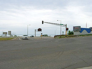
At Medford
, Minnesota
, the on/off ramps lead to roundabout
s rather than standard cross intersections. This is the first site in the state linked to a major highway to use roundabouts.
I-35 splits again into I-35W
and I-35E
in the Minneapolis
/Saint Paul
, Minnesota
area. The mile- and exit-numbering sequence continues along I-35E. At one sharp turn in I-35W near the junction with I-94, it is advised to slow to 35 mph (55 km/h) (although many drivers are able to maintain the speed limit of 55 mph (90 km/h)). Additionally, it is not possible to go from westbound I-94 to northbound I-35W, from southbound I-35W to eastbound I-94, from eastbound I-94 to southbound I-35E, and from northbound I-35E to westbound I-94 without resorting to surface streets.
On I-35E in Minnesota between Minnesota Highway 5
and Interstate 94
, in both directions, trucks weighing more than 9,000 lbs (4,082 kg) are banned from the freeway, and the speed limit drops to 45 mph (70 km/h) but it is rarely obeyed. This section was not completed until the late 1980s (although the route was cleared and graded earlier) due to opposition from the historic Crocus Hill neighborhood, which sits only a few hundred feet from the alignment. The four-lane alignment, "parkway" design was a compromise. The truck bypass for this section is signed on I-494 and I-694 to the east of Saint Paul.
I-35 has an interchange
with I-535
/ U.S. 53 in Duluth, Minnesota
, known locally as the "Can of Worms". This junction
features a pair of left exits from I-35, a stoplight, and lane drops over the I-35 bridge.
The national northern terminus of I-35 is at an intersection
in eastern Duluth. Driver's options include merging with London Road / Minnesota Highway 61
northbound; proceeding through the stop lights onto 26th Avenue East; or turning left onto London Road southbound.
, Oklahoma
, the interstate opened in June 1959. In Moore
, it opened in two parts: the northern half, connecting Moore to Oklahoma City, opened in January 1960. The southern half, linking it to Norman, was opened to traffic in June 1967.
I-35 through Oklahoma largely parallels U.S. Route 77
. This is in large part due to efforts of the towns of Wynnewood
, Paoli
, and Wayne
, which fought to keep I-35 as close as possible to U.S. 77. This was successful due to a threat from Governor Henry Bellmon
to build a toll road rather than I-35, and legislation preventing state funds for the interstate from being spent if it were more than 1 miles (1.6 km) from the U.S. route.
I-35 was completed in Oklahoma in 1971, when parts of the interstate running through Carter Co.
and Murray Co.
were opened to traffic.
The final segment of I-35 (as originally planned) to open was in north central Iowa
, between Mason City
and US 20 near Iowa Falls
. This segment was delayed due to some controversy. Originally, I-35 was to follow the alignment of US 69 from Des Moines
all the way to the Minnesota
border. However, Mason City's business community lobbied for the route to be moved closer to their city. On September 1, 1965, the alignment was changed to instead parallel US 65 through northern Iowa, which brought the highway much closer to Mason City. This, however, created a long diagonal section through Wright
and Franklin
counties. Local farmers objected to their farms being bisected into triangular pieces, and resulting litigation delayed I-35 for several years. A November 1972 ruling rejected a lawsuit filed by the farmers, and the final segment of I-35 was allowed to proceed, eventually opening in 1975. One of the final pieces of the highway puzzle happened in Faribault
, Minnesota
. For approximately 25 years, Highway 35 actually went through the town and travelers had to deal with several traffic lights. In 1975, the highway went around Faribault where today a traveler actually has three exit choices for this southern Minnesota town.
The Paseo Bridge
over the Missouri River
in Kansas City, Missouri was replaced by the dual-span cable-stayed
Christopher S. Bond Bridge
in December 2010.
 The proposed Trans-Texas Corridor
toll-road project includes one proposal (TTC-35) to primarily parallel I-35 from the Mexico border up to the Oklahoma border. There are major disagreements as to what impact this parallel route would have on I-35 in terms of traffic, maintenance, and commerce.
The Trans-Texas Corridor was first proposed by Texas
Governor Rick Perry
in 2002. It consists of a 1,200 foot (366 m) wide highway that also carries utilities such as electricity, petroleum and water as well as railway track and fiber-optic cables. In July 2007, U.S. Representative Duncan Hunter
successfully offered an amendment to House Resolution 3074, the FY2008 Transportation Appropriations Act, prohibiting the use of federal funds for Department of Transportation
participation in the activities of the Security and Prosperity Partnership of North America
(SPP). Hunter stated that: "Unfortunately, very little is known about the NAFTA Super Highway. This amendment will provide Congress the opportunity to exercise oversight of the highway, which remains a subject of question and uncertainty, and ensure that our safety and security will not be compromised in order to promote the business interests of our neighbors." Fellow Republican Congressman and presidential candidate Ron Paul
brought the issue to mainstream prominence during the December 2007 CNN
-YouTube
GOP debate, where he rejected the concept and also called it the NAFTA Superhighway after the North American Free Trade Agreement
and, like Hunter, framed it within the ultimate goal of creating a North American Union
.
United States
The United States of America is a federal constitutional republic comprising fifty states and a federal district...
. I-35 stretches from Laredo
Laredo, Texas
Laredo is the county seat of Webb County, Texas, United States, located on the north bank of the Rio Grande in South Texas, across from Nuevo Laredo, Tamaulipas, Mexico. According to the 2010 census, the city population was 236,091 making it the 3rd largest on the United States-Mexican border,...
, Texas
Texas
Texas is the second largest U.S. state by both area and population, and the largest state by area in the contiguous United States.The name, based on the Caddo word "Tejas" meaning "friends" or "allies", was applied by the Spanish to the Caddo themselves and to the region of their settlement in...
, on the U.S.-Mexico border to Duluth
Duluth, Minnesota
Duluth is a port city in the U.S. state of Minnesota and is the county seat of Saint Louis County. The fourth largest city in Minnesota, Duluth had a total population of 86,265 in the 2010 census. Duluth is also the second largest city that is located on Lake Superior after Thunder Bay, Ontario,...
, Minnesota
Minnesota
Minnesota is a U.S. state located in the Midwestern United States. The twelfth largest state of the U.S., it is the twenty-first most populous, with 5.3 million residents. Minnesota was carved out of the eastern half of the Minnesota Territory and admitted to the Union as the thirty-second state...
, at Minnesota Highway 61
Minnesota State Highway 61
Minnesota State Highway 61 is a highway in northeast Minnesota, which runs from the junction of Interstate Highway 35 and Minnesota 61 in Duluth and continues northeast to its northern terminus at the U.S.-Canadian border near Grand Portage...
(London Road) and 26th Avenue East. Many interstates used to have splits or spurs indicated with suffixed letters (N
North
North is a noun, adjective, or adverb indicating direction or geography.North is one of the four cardinal directions or compass points. It is the opposite of south and is perpendicular to east and west.By convention, the top side of a map is north....
/S
South
South is a noun, adjective, or adverb indicating direction or geography.South is one of the four cardinal directions or compass points. It is the opposite of north and is perpendicular to east and west.By convention, the bottom side of a map is south....
/E
East
East is a noun, adjective, or adverb indicating direction or geography.East is one of the four cardinal directions or compass points. It is the opposite of west and is perpendicular to north and south.By convention, the right side of a map is east....
/W
West
West is a noun, adjective, or adverb indicating direction or geography.West is one of the four cardinal directions or compass points. It is the opposite of east and is perpendicular to north and south.By convention, the left side of a map is west....
), but I-35 is the only one that still has such divisions. In two stretches, both through twin cities, the highway splits into Interstate 35E (Dallas and St. Paul
Saint Paul, Minnesota
Saint Paul is the capital and second-most populous city of the U.S. state of Minnesota. The city lies mostly on the east bank of the Mississippi River in the area surrounding its point of confluence with the Minnesota River, and adjoins Minneapolis, the state's largest city...
) and Interstate 35W (Fort Worth
Fort Worth, Texas
Fort Worth is the 16th-largest city in the United States of America and the fifth-largest city in the state of Texas. Located in North Central Texas, just southeast of the Texas Panhandle, the city is a cultural gateway into the American West and covers nearly in Tarrant, Parker, Denton, and...
and Minneapolis).
Interstate 35 does not directly connect to either international border. I-35's southern terminus is a traffic signal in Laredo
Laredo, Texas
Laredo is the county seat of Webb County, Texas, United States, located on the north bank of the Rio Grande in South Texas, across from Nuevo Laredo, Tamaulipas, Mexico. According to the 2010 census, the city population was 236,091 making it the 3rd largest on the United States-Mexican border,...
, Texas
Texas
Texas is the second largest U.S. state by both area and population, and the largest state by area in the contiguous United States.The name, based on the Caddo word "Tejas" meaning "friends" or "allies", was applied by the Spanish to the Caddo themselves and to the region of their settlement in...
, just short of the United States-Mexico border. Travelers going south can take one of two toll bridges across the Rio Grande
Rio Grande
The Rio Grande is a river that flows from southwestern Colorado in the United States to the Gulf of Mexico. Along the way it forms part of the Mexico – United States border. Its length varies as its course changes...
and the Mexican border—straight ahead into Juarez-Lincoln International Bridge
Juárez-Lincoln International Bridge
The Juárez–Lincoln International Bridge is one of four vehicular international bridges located in the cities of Laredo, Texas, and Nuevo Laredo, Tamaulipas, that connect the United States and Mexico over the Rio Grande...
, or via Interstate 35 Business through downtown Laredo into Gateway to the Americas International Bridge
Gateway to the Americas International Bridge
The Gateway to the Americas International Bridge is one of four vehicular international bridges located in the cities of Laredo, Texas, and Nuevo Laredo, Tamaulipas, that connect the United States and Mexico over the Rio Grande...
. To the north, I-35 terminates in Duluth
Duluth, Minnesota
Duluth is a port city in the U.S. state of Minnesota and is the county seat of Saint Louis County. The fourth largest city in Minnesota, Duluth had a total population of 86,265 in the 2010 census. Duluth is also the second largest city that is located on Lake Superior after Thunder Bay, Ontario,...
, Minnesota
Minnesota
Minnesota is a U.S. state located in the Midwestern United States. The twelfth largest state of the U.S., it is the twenty-first most populous, with 5.3 million residents. Minnesota was carved out of the eastern half of the Minnesota Territory and admitted to the Union as the thirty-second state...
, with connections to Canada from the interstate's terminus via Minnesota Highway 61
Minnesota State Highway 61
Minnesota State Highway 61 is a highway in northeast Minnesota, which runs from the junction of Interstate Highway 35 and Minnesota 61 in Duluth and continues northeast to its northern terminus at the U.S.-Canadian border near Grand Portage...
to Grand Portage
Grand Portage, Minnesota
Grand Portage is an unorganized territory in Cook County, Minnesota, on Lake Superior, at the northeast corner of the state near the border with northwestern Ontario. The population was 557 at the 2000 census...
, or north to the border at International Falls
International Falls, Minnesota
International Falls is a city in and the county seat of Koochiching County, Minnesota, United States. The population was 6,424 at the 2010 census....
by U.S. Route 53
U.S. Route 53
U.S. Route 53 is a north–south U.S. highway that runs for 403 miles from La Crosse, Wisconsin to northern Minnesota. It is the primary north–south route in northwestern Wisconsin, serving as a vital link between I-94 at Eau Claire, Wisconsin and the city of Duluth, Minnesota...
in Duluth, but that route is more typically accessed from the south by Minnesota Highway 33
Minnesota State Highway 33
Minnesota State Highway 33 is a highway in northeast Minnesota, which runs from its interchange with Interstate 35 at Cloquet and continues north to its northern terminus at its interchange with U.S. Highway 53 at Independence...
at Cloquet
Cloquet, Minnesota
As of the census of 2000, there were 11,201 people, 4,636 households, and 2,967 families residing in the city. The population density was 317.9 people per square mile . There were 4,805 housing units at an average density of 136.4 per square mile...
.
Route description
|-|TX
Interstate 35 in Texas
Interstate 35 in Texas is a major north–south Interstate Highway running from Laredo near the United States-Mexico border to the Red River north of Gainesville where it crosses into Oklahoma. Along its route, it passes through the cities of San Antonio, Austin, and Waco before it splits into two...
|505
|813
|-
|OK
Interstate 35 in Oklahoma
Oklahoma is the second state that Interstate 35 passes through from south to north. In Oklahoma, I-35 runs from the Red River at the Texas border to the Kansas line near Braman, for a length of 236 miles . I-35 has one spur route in the state, Interstate 235 in the inner city of Oklahoma...
|235
|378
|-
|KS
|234
|377
|-
|MO
|114
|183
|-
|IA
Interstate 35 in Iowa
In the U.S. state of Iowa, Interstate 35 runs north–south through the Des Moines area, parallel to US 65 and US 69. Segments of the Interstate Highway overlap with Interstate 80 and Iowa Highway 27, Iowa's designation for the Avenue of the Saints....
|218
|351
|-
|MN
Interstate 35 in Minnesota
In the U.S. state of Minnesota, Interstate 35 is a highway in southeast, east-central, and northeast Minnesota. The route runs north–south from the Iowa state line through the twin cities of Minneapolis and Saint Paul; where it splits into Interstates 35E and 35W; and ends in the city of...
|259
|416
|-
|
|1565
|2518
|}
Texas
Rio Grande
The Rio Grande is a river that flows from southwestern Colorado in the United States to the Gulf of Mexico. Along the way it forms part of the Mexico – United States border. Its length varies as its course changes...
and the international border with Mexico
Mexico
The United Mexican States , commonly known as Mexico , is a federal constitutional republic in North America. It is bordered on the north by the United States; on the south and west by the Pacific Ocean; on the southeast by Guatemala, Belize, and the Caribbean Sea; and on the east by the Gulf of...
. Through Webb
Webb County, Texas
Webb County is a county located in the U.S. state of Texas. The official 2010 population for the county is 250,304. In 2000, its population was 193,117, and in 2006 its population had been estimated to have reached to 231,470. Its county seat is Laredo...
, La Salle, and Frio Counties, it has a mostly north-northeastern course, turning more northeast around Moore
Moore, Texas
Moore is a census-designated place in Frio County, Texas, United States. The population was 644 at the 2000 census.-Geography:Moore is located at ....
. It then cuts across the corners of Medina and Atascosa Counties before entering Bexar County
Bexar County, Texas
As of the census of 2000, there were 1,392,931 people, 488,942 households, and 345,681 families residing in the county. The population density was 1,117 people per square mile . There were 521,359 housing units at an average density of 418 per square mile...
and San Antonio.
Interstate 35 is named the Pan Am Expressway
Pan-American Highway
The Pan-American Highway is a network of roads measuring about in total length. Except for an rainforest break, called the Darién Gap, the road links the mainland nations of the Americas in a connected highway system. According to Guinness World Records, the Pan-American Highway is the world's...
in San Antonio. There, it has brief concurrencies
Concurrency (road)
A concurrency, overlap, or coincidence in a road network is an instance of one physical road bearing two or more different highway, motorway, or other route numbers...
with both Interstate 10
Interstate 10
Interstate 10 is the fourth-longest Interstate Highway in the United States, after I-90, I-80, and I-40. It is the southernmost east–west, coast-to-coast Interstate Highway, although I-4 and I-8 are further south. It stretches from the Pacific Ocean at State Route 1 in Santa Monica,...
and Interstate 410
Interstate 410
Interstate 410 is a loop route of Interstate 10 around San Antonio, Texas. It is identified as Connally Loop in honor of former Texas governor John Connally...
, and serves as the northern terminus of Interstate 37
Interstate 37
Interstate 37 is a intrastate Interstate Highway located within the U.S. state of Texas. The highway was first designated in 1959 as a route between Corpus Christi and San Antonio. Construction in the urban areas of Corpus Christi and San Antonio began in the 1960s and the segments of the...
. I-35 heads northward out of the city towards the state capital, Austin
Austin, Texas
Austin is the capital city of the U.S. state of :Texas and the seat of Travis County. Located in Central Texas on the eastern edge of the American Southwest, it is the fourth-largest city in Texas and the 14th most populous city in the United States. It was the third-fastest-growing large city in...
.
In Austin, Interstate 35 is the Interregional Highway. Throughout Austin, elevated express lanes were constructed on either side of the original freeway. Prior to this expansion, this section included an at-grade railroad crossing
Level crossing
A level crossing occurs where a railway line is intersected by a road or path onone level, without recourse to a bridge or tunnel. It is a type of at-grade intersection. The term also applies when a light rail line with separate right-of-way or reserved track crosses a road in the same fashion...
, which is extremely unusual for a freeway. From Austin, I-35 goes through Round Rock
Round Rock, Texas
Round Rock is a city in Travis and Williamson counties in the U.S. state of Texas. It is part of the metropolitan area. The 2010 census places the population at 99,887....
, Temple
Temple, Texas
Temple is a city in Bell County, Texas, United States. Located near the county seat of Belton, Temple lies in the region referred to as Central Texas. Located off Interstate 35, Temple is 65 miles north of Austin and 34 miles south of Waco. In the 2010 Census, Temple's population was 66,102, an...
, and Waco
Waco, Texas
Waco is a city in and the county seat of McLennan County, Texas. Situated along the Brazos River and on the I-35 corridor, halfway between Dallas and Austin, it is the economic, cultural, and academic center of the 'Heart of Texas' region....
. In Waco, I-35 is the Jack Kultgen Freeway. The campuses of the University of Texas and Baylor University are located directly adjacent to I-35.
I-35 then heads to Hillsboro
Hillsboro, Texas
Hillsboro is a city in and the county seat of Hill County in Central Texas. The population was 8,232 at the 2000 census.Hillsboro, located on Interstate 35 where I-35E and I-35W meet south of the Dallas-Fort Worth Metroplex, is the primary center for trade and commerce in Hill County...
, where it splits up into I-35W
Interstate 35W (Texas)
Interstate 35W , an Interstate Highway, is the western half of Interstate 35 where it splits to serve different cities in Texas. I-35 splits into two branch routes, I-35W and I-35E at Hillsboro. I-35W runs north for , carrying its own separate sequence of exit numbers. It runs through Fort Worth...
and I-35E
Interstate 35E (Texas)
Interstate 35E , an Interstate Highway, is the eastern half of Interstate 35 where it splits to serve different cities in Texas. I-35 splits into two branch routes, I-35W and I-35E at Hillsboro. I-35E runs north for , maintaining I-35's sequence of exit numbers. It runs through Dallas before...
and runs through the Dallas
Dallas, Texas
Dallas is the third-largest city in Texas and the ninth-largest in the United States. The Dallas-Fort Worth Metroplex is the largest metropolitan area in the South and fourth-largest metropolitan area in the United States...
/Fort Worth
Fort Worth, Texas
Fort Worth is the 16th-largest city in the United States of America and the fifth-largest city in the state of Texas. Located in North Central Texas, just southeast of the Texas Panhandle, the city is a cultural gateway into the American West and covers nearly in Tarrant, Parker, Denton, and...
area. The official mile markers follow I-35E through Dallas—I-35W, which is 85 miles (136.8 km) in length, carries its own mileage from Hillsboro to Denton, as though it were an x35 loop. In Dallas, I-35 is the R.L. Thornton Freeway south of I-30, which picks up the name heading east. North of I-30, it is the Stemmons Freeway.
After passing through D/FW, I-35's two forks merge in Denton
Denton, Texas
The city of Denton is the county seat of Denton County, Texas in the United States. Its population was 119,454 according to the 2010 U.S. Census, making it the eleventh largest city in the Dallas/Fort Worth Metroplex...
. The unified interstate then continues north to Gainesville
Gainesville, Texas
Gainesville is a city in and the county seat of Cooke County, Texas, United States. The population was 15,538 at the 2000 census.-History:...
before crossing the Red River into Oklahoma.
Oklahoma
Ardmore, Oklahoma
Ardmore is a business, cultural and tourism city in and the county seat of Carter County, Oklahoma, United States. As of the 2010 Census, the city had a population of 24,283, while a 2007 estimate has the Ardmore micropolitan statistical area totaling 56,694 residents...
and the cities of the Oklahoma City Metropolitan Area
Oklahoma City metropolitan area
-Metro-area suburbs and exurbs:The following communities are suburbs and exurbs of Oklahoma City with populations of at least 1,000 found within the bounds of State Highway 33 to the north, State Highway 18 and US-177 to the east, State Highway 39 and State Highway 9 to the south, and US-81 to the...
such as Norman
Norman, Oklahoma
Norman is a city in Cleveland County, Oklahoma, United States, and is located south of downtown Oklahoma City. It is part of the Oklahoma City metropolitan area. As of the 2010 census, Norman was to have 110,925 full-time residents, making it the third-largest city in Oklahoma and the...
, Guthrie
Guthrie, Oklahoma
Guthrie is a city in and the county seat of Logan County, Oklahoma, United States, and a part of the Oklahoma City Metroplex. The population was 9,925 at the 2000 census.Guthrie was the territorial and later the first state capital for Oklahoma...
, Edmond
Edmond, Oklahoma
Edmond is a city in Oklahoma County, Oklahoma, United States, and a part of the Oklahoma City metropolitan area in the central part of the state. As of the 2010 census, the population was 81,405, making it the sixth largest city in the state of Oklahoma....
, and the state capital and largest city, Oklahoma City. In Downtown Oklahoma City
Downtown Oklahoma City
Downtown Oklahoma City is located at the geographic center of the Oklahoma City metropolitan area and is the principal business district of the city. With 115 city blocks and around of office space, downtown Oklahoma City also is the economic, financial, and entertainment center of the city...
, I-35 has a major junction with I-40 and spurs into I-235
Interstate 235 (Oklahoma)
Interstate 235 in Oklahoma is also known as the Centennial Expressway. The spur route of Interstate 35 is a 5.4-mile-long north–south spur route in central and north-central Oklahoma City. It connects northbound to U.S. Highway 77 on to suburban Edmond and southbound at Interstate 44 on to...
through the north central inner city.
Kansas
Between the Oklahoma state line and EmporiaEmporia, Kansas
Emporia is a city in and the county seat of Lyon County, Kansas, United States. As of the 2010 census, the city population was 24,916. Emporia lies between Topeka and Wichita at the intersection of U.S. Route 50 with Interstates 335 and 35 on the Kansas Turnpike...
, I-35 is part of the Kansas Turnpike
Kansas Turnpike
The Kansas Turnpike is a freeway-standard toll road that lies entirely within the U.S. state of Kansas. It runs in a general southwest-northeast direction from the Oklahoma border, and passes through several major Kansas cities, including Wichita, Topeka, Lawrence and Kansas City...
. This section of interstate serves Wichita
Wichita, Kansas
Wichita is the largest city in the U.S. state of Kansas.As of the 2010 census, the city population was 382,368. Located in south-central Kansas on the Arkansas River, Wichita is the county seat of Sedgwick County and the principal city of the Wichita metropolitan area...
and passes through the Flint Hills
Flint Hills
The Flint Hills, historically known as Bluestem Pastures or Blue Stem Hills, are a band of hills in eastern Kansas stretching into north-central Oklahoma, extending from Marshall County, Kansas and Washington County, Kansas in the north to Cowley County, Kansas and Osage County, Oklahoma in the south...
area. At Emporia, I-35 branches off on its own alignment. This free section of I-35 provides access to Ottawa
Ottawa, Kansas
Ottawa is a city situated along the Marais des Cygnes River in the central part of Franklin County, located in east-central Kansas, 50 miles southwest of Kansas City, Mo., in the central United States. As of the 2010 census, the city population was 12,649. It is the county seat and most populous...
before entering the Kansas City Metropolitan Area
Kansas City Metropolitan Area
The Kansas City Metropolitan Area is a fifteen-county metropolitan area that is anchored by Kansas City, Missouri and is bisected by the border between the states of Missouri and Kansas. As of the 2010 Census, the metropolitan area has a population of 2,035,334. The metropolitan area is the...
, where it serves Johnson County
Johnson County, Kansas
Johnson County is a county located in northeast Kansas, in the central United States. The county is largely suburban, being part of the Kansas City metropolitan area, and containing many of its affluent southwestern suburbs. As of the 2010 census, the county population was 544,179. Its county...
, and Kansas City, Kansas
Kansas City, Kansas
Kansas City is the third-largest city in the state of Kansas and is the county seat of Wyandotte County. It is a suburb of Kansas City, Missouri, and is the third largest city in the Kansas City Metropolitan Area. The city is part of a consolidated city-county government known as the "Unified...
.
Of note on the route, at several points between Cassoday and Emporia in the Flint Hills dirt driveways that provide direct access without a ramp, for cattle trucks, may be found in either direction along the highway.
BETO Junction is a highway intersection in Coffey County, Kansas
Coffey County, Kansas
Coffey County is a county located in East Central Kansas, in the Central United States. As of the 2010 census, the county population was 8,601...
that is the intersection of U.S. Highway 75 and I-35. It derives its name from the four major cities nearest the intersection: Burlington
Burlington, Kansas
Burlington is a city in and the county seat of Coffey County, Kansas, United States. As of the 2010 census, the city population was 2,674.-Geography:Burlington is located at...
, Emporia
Emporia, Kansas
Emporia is a city in and the county seat of Lyon County, Kansas, United States. As of the 2010 census, the city population was 24,916. Emporia lies between Topeka and Wichita at the intersection of U.S. Route 50 with Interstates 335 and 35 on the Kansas Turnpike...
, Topeka
Topeka, Kansas
Topeka |Kansa]]: Tó Pee Kuh) is the capital city of the U.S. state of Kansas and the county seat of Shawnee County. It is situated along the Kansas River in the central part of Shawnee County, located in northeast Kansas, in the Central United States. As of the 2010 census, the city population was...
, and Ottawa
Ottawa, Kansas
Ottawa is a city situated along the Marais des Cygnes River in the central part of Franklin County, located in east-central Kansas, 50 miles southwest of Kansas City, Mo., in the central United States. As of the 2010 census, the city population was 12,649. It is the county seat and most populous...
. It is located 16 miles (25.7 km) north of Burlington at exit 155. Historically, the intersection referred to as "BETO Junction" before I-35 was constructed was located on the old US 75 highway alignments 2 miles (3.2 km) south and 2 miles (3.2 km) east, near Waverly, Kansas
Waverly, Kansas
Waverly is a city in Coffey County, Kansas, United States. The population was 589 at the 2000 census.-Geography:Waverly is located at ....
.
Missouri
I-35 enters Missouri two miles (3 km) southwest of Kansas City's Central Business DistrictCentral business district
A central business district is the commercial and often geographic heart of a city. In North America this part of a city is commonly referred to as "downtown" or "city center"...
as a six-lane highway. After merging with Southwest Trafficway
Southwest Trafficway
Southwest Trafficway is a major north/south road that runs in Kansas City, Missouri from 27th Street & I-35 to 43rd Street at Madison Avenue and Belleview Avenue.Southwest Trafficway connects Downtown Kansas City to Westport and Country Club Plaza...
and Broadway, it becomes eight lanes and continues north to downtown Kansas City, where it serves as the west and north legs of the Downtown freeway loop
Downtown freeway loop (Kansas City)
The downtown loop, also nicknamed the "Alphabet Loop", is a complex layout of highways in downtown Kansas City, Missouri involving 23 exits, four Interstate Highways, four U.S. Highways and numerous city streets...
. Along the north edge of the loop, I-35 joins with I-70
Interstate 70
Interstate 70 is an Interstate Highway in the United States that runs from Interstate 15 near Cove Fort, Utah, to a Park and Ride near Baltimore, Maryland. It was the first Interstate Highway project in the United States. I-70 approximately traces the path of U.S. Route 40 east of the Rocky...
immediately west of Broadway and carries six lanes of traffic with a speed limit of 45 mi/h. Upon leaving the loop, Interstate 29
Interstate 29
Interstate 29 is an Interstate Highway in the Midwestern United States. I-29 runs from Kansas City, Missouri, at a junction with Interstate 35 and Interstate 70 to the Canadian border near Pembina, North Dakota, where it connects with Manitoba Highway 75 via the short Manitoba Highway 29.-Route...
begins, concurrent with I-35. The two interstates cross the Missouri River
Missouri River
The Missouri River flows through the central United States, and is a tributary of the Mississippi River. It is the longest river in North America and drains the third largest area, though only the thirteenth largest by discharge. The Missouri's watershed encompasses most of the American Great...
together on the Bond Bridge.
After crossing the river, I-29 and I-35 split. I-35 heads north to Cameron, Missouri
Cameron, Missouri
Cameron is a city in Clinton and DeKalb Counties in the U.S. state of Missouri. The population was 8,312 at the 2000 census.The Clinton County portion of Cameron is part of the Kansas City, MO–KS Metropolitan Statistical Area, while the DeKalb County portion is part of the St...
, and then continues northward to the Iowa state line.
Iowa
I-35 is part of the Avenue of the SaintsAvenue of the Saints
The Avenue of the Saints is a highway in the Midwestern United States that connects St. Paul, Minnesota, and St. Louis, Missouri.-Missouri:Within Missouri, the Avenue of the Saints is Interstate 64, U.S...
between Clear Lake
Clear Lake, Iowa
Clear Lake is a city in Cerro Gordo County, Iowa, United States. The population was 8,161 at the 2000 census. The city is named for the large lake on which it is located. It is the home of a number of marinas, state parks and tourism-related businesses. Clear Lake is also a major stop on Interstate...
and St. Paul, Minnesota. A four-lane link has been completed between Clear Lake and Interstate 380
Interstate 380 (Iowa)
Interstate 380 is a auxiliary Interstate Highway located in eastern Iowa. The route extends from Interstate 80 near Coralville to Waterloo. I-380 connects the cities of Cedar Rapids and Waterloo, the second- and fifth-largest cities in the state, respectively, to the Interstate Highway System. ...
in Waterloo
Waterloo, Iowa
Waterloo is a city in and the county seat of Black Hawk County, Iowa, United States. As of the 2010 United States Census the population decreased by 0.5% to 68,406. Waterloo is part of the Waterloo – Cedar Falls Metropolitan Statistical Area, and is the more populous of the two...
, Iowa
Iowa
Iowa is a state located in the Midwestern United States, an area often referred to as the "American Heartland". It derives its name from the Ioway people, one of the many American Indian tribes that occupied the state at the time of European exploration. Iowa was a part of the French colony of New...
.
In the southern sections of the state, I-35 is parallel to U.S. Route 69
U.S. Route 69
U.S. Route 69 is a north–south United States highway. When it was first created, it was only long, but it has since been expanded into a Minnesota to Texas cross-country route. The highway's southern terminus is in Port Arthur, Texas at an intersection with State Highway 87...
, for much of its course.
In Des Moines, I-35 has a 12 miles (19.3 km) overlap
Concurrency (road)
A concurrency, overlap, or coincidence in a road network is an instance of one physical road bearing two or more different highway, motorway, or other route numbers...
with I-80. The concurrency takes place northwest of the downtown district of the city. At exit 127 of I-80, the overlap turns east and terminates at exit 137 via an interchange with Interstate 235
Interstate 235 (Iowa)
Interstate 235 in Iowa is an auxiliary Interstate Highway that runs just north of downtown Des Moines through the heart of the Des Moines metropolitan area. I-235 runs from the junction of Interstate 35 and Interstate 80 in West Des Moines to the separation of the same two interstates in Ankeny...
.
North of Des Moines, I-35 is mainly parallel with US 69, traversing a vast and rural area of Iowa.
Minnesota
At Medford
Medford, Minnesota
Medford is a city in Steele County, Minnesota, United States. The population was 1,239 at the 2010 census.-Geography:According to the United States Census Bureau, the city has a total area of , all land...
, Minnesota
Minnesota
Minnesota is a U.S. state located in the Midwestern United States. The twelfth largest state of the U.S., it is the twenty-first most populous, with 5.3 million residents. Minnesota was carved out of the eastern half of the Minnesota Territory and admitted to the Union as the thirty-second state...
, the on/off ramps lead to roundabout
Roundabout
A roundabout is the name for a road junction in which traffic moves in one direction around a central island. The word dates from the early 20th century. Roundabouts are common in many countries around the world...
s rather than standard cross intersections. This is the first site in the state linked to a major highway to use roundabouts.
I-35 splits again into I-35W
Interstate 35W (Minnesota)
Interstate 35W , is an Interstate Highway in the U.S. state of Minnesota, passing through downtown Minneapolis. It is one of two through routes for Interstate 35 through the Twin Cities of Minneapolis and Saint Paul, the other being Interstate 35E through downtown Saint Paul...
and I-35E
Interstate 35E (Minnesota)
Interstate 35E is an Interstate Highway in the U.S. state of Minnesota, passing through downtown Saint Paul. It is one of two through routes for Interstate 35 through the Twin Cities of Minneapolis and Saint Paul, the other being Interstate 35W through Minneapolis. Thus, both ends of I-35E are...
in the Minneapolis
Minneapolis, Minnesota
Minneapolis , nicknamed "City of Lakes" and the "Mill City," is the county seat of Hennepin County, the largest city in the U.S. state of Minnesota, and the 48th largest in the United States...
/Saint Paul
Saint Paul, Minnesota
Saint Paul is the capital and second-most populous city of the U.S. state of Minnesota. The city lies mostly on the east bank of the Mississippi River in the area surrounding its point of confluence with the Minnesota River, and adjoins Minneapolis, the state's largest city...
, Minnesota
Minnesota
Minnesota is a U.S. state located in the Midwestern United States. The twelfth largest state of the U.S., it is the twenty-first most populous, with 5.3 million residents. Minnesota was carved out of the eastern half of the Minnesota Territory and admitted to the Union as the thirty-second state...
area. The mile- and exit-numbering sequence continues along I-35E. At one sharp turn in I-35W near the junction with I-94, it is advised to slow to 35 mph (55 km/h) (although many drivers are able to maintain the speed limit of 55 mph (90 km/h)). Additionally, it is not possible to go from westbound I-94 to northbound I-35W, from southbound I-35W to eastbound I-94, from eastbound I-94 to southbound I-35E, and from northbound I-35E to westbound I-94 without resorting to surface streets.
On I-35E in Minnesota between Minnesota Highway 5
Minnesota State Highway 5
Minnesota State Highway 5 is a highway in Minnesota, which runs from its intersection with State Highways 19 and 22 in Gaylord and continues east and northeast to its eastern terminus at its interchange with State Highway 36 and Washington County Road 5 in Stillwater...
and Interstate 94
Interstate 94 in Minnesota
In the U.S. state of Minnesota, Interstate 94 runs east–west through the central portion of the state. The route connects the cities of Moorhead, Fergus Falls, Alexandria, St...
, in both directions, trucks weighing more than 9,000 lbs (4,082 kg) are banned from the freeway, and the speed limit drops to 45 mph (70 km/h) but it is rarely obeyed. This section was not completed until the late 1980s (although the route was cleared and graded earlier) due to opposition from the historic Crocus Hill neighborhood, which sits only a few hundred feet from the alignment. The four-lane alignment, "parkway" design was a compromise. The truck bypass for this section is signed on I-494 and I-694 to the east of Saint Paul.
I-35 has an interchange
Interchange (road)
In the field of road transport, an interchange is a road junction that typically uses grade separation, and one or more ramps, to permit traffic on at least one highway to pass through the junction without directly crossing any other traffic stream. It differs from a standard intersection, at which...
with I-535
Interstate 535
Interstate 535 is a long Interstate Highway spur route of Interstate 35 in Minnesota and Wisconsin, in the United States. It is paired with U.S...
/ U.S. 53 in Duluth, Minnesota
Duluth, Minnesota
Duluth is a port city in the U.S. state of Minnesota and is the county seat of Saint Louis County. The fourth largest city in Minnesota, Duluth had a total population of 86,265 in the 2010 census. Duluth is also the second largest city that is located on Lake Superior after Thunder Bay, Ontario,...
, known locally as the "Can of Worms". This junction
Junction (road)
A road junction is a location where vehicular traffic going in different directions can proceed in a controlled manner designed to minimize accidents. In some cases, vehicles can change between different routes or directions of travel.-Origins:...
features a pair of left exits from I-35, a stoplight, and lane drops over the I-35 bridge.
The national northern terminus of I-35 is at an intersection
Intersection (road)
An intersection is a road junction where two or more roads either meet or cross at grade . An intersection may be 3-way - a T junction or fork, 4-way - a crossroads, or 5-way or more...
in eastern Duluth. Driver's options include merging with London Road / Minnesota Highway 61
Minnesota State Highway 61
Minnesota State Highway 61 is a highway in northeast Minnesota, which runs from the junction of Interstate Highway 35 and Minnesota 61 in Duluth and continues northeast to its northern terminus at the U.S.-Canadian border near Grand Portage...
northbound; proceeding through the stop lights onto 26th Avenue East; or turning left onto London Road southbound.
History
Some sections of I-35 in Oklahoma City were already built in 1953, before the Interstate system was created. Through NormanNorman, Oklahoma
Norman is a city in Cleveland County, Oklahoma, United States, and is located south of downtown Oklahoma City. It is part of the Oklahoma City metropolitan area. As of the 2010 census, Norman was to have 110,925 full-time residents, making it the third-largest city in Oklahoma and the...
, Oklahoma
Oklahoma
Oklahoma is a state located in the South Central region of the United States of America. With an estimated 3,751,351 residents as of the 2010 census and a land area of 68,667 square miles , Oklahoma is the 28th most populous and 20th-largest state...
, the interstate opened in June 1959. In Moore
Moore, Oklahoma
Moore is a city in Cleveland County, Oklahoma and is part of the Oklahoma City Metropolitan Area. The population was 55,081 at the 2010 census, making it the seventh largest city in the state of Oklahoma....
, it opened in two parts: the northern half, connecting Moore to Oklahoma City, opened in January 1960. The southern half, linking it to Norman, was opened to traffic in June 1967.
I-35 through Oklahoma largely parallels U.S. Route 77
U.S. Route 77
U.S. Route 77 is a north–south United States highway. It is unsigned in and around Dallas, Texas. Its historic segment through South Dakota and Minnesota was decommissioned with the advent of Interstate 29 but otherwise the route has been spared the decommissioning that has shortened other US...
. This is in large part due to efforts of the towns of Wynnewood
Wynnewood, Oklahoma
Wynnewood is a city in Garvin County, Oklahoma, United States. The population was 2,367 at the 2000 census.- History :There is also a Wynnewood, Pennsylvania. The railroad workers were from Pennsylvania and named the existing townsites what they wanted. They also named Paoli and Ardmore, Oklahoma...
, Paoli
Paoli, Oklahoma
Paoli is a town in Garvin County, Oklahoma, United States. The population was 649 at the 2000 census. It was named after Paoli, an unincorporated community outside of Philadelphia, Pennsylvania, where most of the railroad workers that basically built the town were from.-Geography:Paoli is located...
, and Wayne
Wayne, Oklahoma
Wayne is a town in McClain County, Oklahoma, United States. Wayne and McClain County are part of the Oklahoma City Metropolitan Area The population was 519 according to the 2000 census and is part of the "Heart of Oklahoma" area. Wayne was so named by early railroad workers from Pennsylvania who...
, which fought to keep I-35 as close as possible to U.S. 77. This was successful due to a threat from Governor Henry Bellmon
Henry Bellmon
Henry Louis "Harry" Bellmon was an American Republican politician from Oklahoma. He was a member of the Oklahoma Legislature, the 18th and 23rd Governor of Oklahoma , and a two-term United States Senator.-Service in World War II:Bellmon was born in Tonkawa, Oklahoma and graduated from Billings...
to build a toll road rather than I-35, and legislation preventing state funds for the interstate from being spent if it were more than 1 miles (1.6 km) from the U.S. route.
I-35 was completed in Oklahoma in 1971, when parts of the interstate running through Carter Co.
Carter County, Oklahoma
Carter County is a county located in the U.S. state of Oklahoma. As of 2010, the population was 47,557. Its county seat is Ardmore.Carter County is part of the Ardmore, Oklahoma, Micropolitan Statistical Area.-Geography:According to the U.S...
and Murray Co.
Murray County, Oklahoma
Murray County is a county located in the U.S. state of Oklahoma. As of 2000, the population was 12,623. Its county seat is Sulphur.-Geography:...
were opened to traffic.
The final segment of I-35 (as originally planned) to open was in north central Iowa
Iowa
Iowa is a state located in the Midwestern United States, an area often referred to as the "American Heartland". It derives its name from the Ioway people, one of the many American Indian tribes that occupied the state at the time of European exploration. Iowa was a part of the French colony of New...
, between Mason City
Mason City, Iowa
Mason City is the county seat of Cerro Gordo County, Iowa, United States. The population was 28,079 in the 2010 census, a decline from 29,172 in the 2000 census. The Mason City Micropolitan Statistical Area includes all of Cerro Gordo and Worth counties....
and US 20 near Iowa Falls
Iowa Falls, Iowa
Iowa Falls is a city in Hardin County, Iowa, United States. Iowa Falls is the home of Ellsworth Community College. It is also a regional transportation center, located along U.S. Routes 20 and 65 and the Canadian National and Union Pacific Railroads. The population was 5,193 at the 2000 census. A...
. This segment was delayed due to some controversy. Originally, I-35 was to follow the alignment of US 69 from Des Moines
Des Moines, Iowa
Des Moines is the capital and the most populous city in the US state of Iowa. It is also the county seat of Polk County. A small portion of the city extends into Warren County. It was incorporated on September 22, 1851, as Fort Des Moines which was shortened to "Des Moines" in 1857...
all the way to the Minnesota
Minnesota
Minnesota is a U.S. state located in the Midwestern United States. The twelfth largest state of the U.S., it is the twenty-first most populous, with 5.3 million residents. Minnesota was carved out of the eastern half of the Minnesota Territory and admitted to the Union as the thirty-second state...
border. However, Mason City's business community lobbied for the route to be moved closer to their city. On September 1, 1965, the alignment was changed to instead parallel US 65 through northern Iowa, which brought the highway much closer to Mason City. This, however, created a long diagonal section through Wright
Wright County, Iowa
-2010 census:The 2010 census recorded a population of 13,229 in the county, with a population density of . There were 6,529 housing units, of which 5,625 were occupied.-2000 census:...
and Franklin
Franklin County, Iowa
-2010 census:The 2010 census recorded a population of 10,680 in the county, with a population density of . There were 4,894 housing units, of which 4,332 were occupied.-2000 census:...
counties. Local farmers objected to their farms being bisected into triangular pieces, and resulting litigation delayed I-35 for several years. A November 1972 ruling rejected a lawsuit filed by the farmers, and the final segment of I-35 was allowed to proceed, eventually opening in 1975. One of the final pieces of the highway puzzle happened in Faribault
Faribault, Minnesota
As of the census of 2000, there were 20,818 people, 7,472 households, and 4,946 families residing in the city. The population density was 1,644.8 people per square mile . There were 7,668 housing units at an average density of 605.8 per square mile...
, Minnesota
Minnesota
Minnesota is a U.S. state located in the Midwestern United States. The twelfth largest state of the U.S., it is the twenty-first most populous, with 5.3 million residents. Minnesota was carved out of the eastern half of the Minnesota Territory and admitted to the Union as the thirty-second state...
. For approximately 25 years, Highway 35 actually went through the town and travelers had to deal with several traffic lights. In 1975, the highway went around Faribault where today a traveler actually has three exit choices for this southern Minnesota town.
The Paseo Bridge
Paseo Bridge
The Paseo Bridge was a suspension bridge over the Missouri River in Kansas City, Missouri. Before being replaced by the Christopher S. Bond Bridge, it carried Interstates 29 and 35 and U.S. Route 71 over the river.-Background and History:...
over the Missouri River
Missouri River
The Missouri River flows through the central United States, and is a tributary of the Mississippi River. It is the longest river in North America and drains the third largest area, though only the thirteenth largest by discharge. The Missouri's watershed encompasses most of the American Great...
in Kansas City, Missouri was replaced by the dual-span cable-stayed
Cable-stayed bridge
A cable-stayed bridge is a bridge that consists of one or more columns , with cables supporting the bridge deck....
Christopher S. Bond Bridge
Christopher S. Bond Bridge (Kansas City)
The Christopher S. Bond Bridge in Kansas City, Missouri is a cable-stayed bridge across the Missouri River. The bridge opened to limited traffic on September 27, 2010 and all lanes opened on December 18, 2010...
in December 2010.
"NAFTA Superhighway" controversy
Trans-Texas Corridor
The Trans-Texas Corridor was a transportation network that was discontinued in the planning and early construction stages in the U.S. State of Texas. The network, as originally envisioned, would have been composed of a network of supercorridors up to wide to carry parallel links of tollways,...
toll-road project includes one proposal (TTC-35) to primarily parallel I-35 from the Mexico border up to the Oklahoma border. There are major disagreements as to what impact this parallel route would have on I-35 in terms of traffic, maintenance, and commerce.
The Trans-Texas Corridor was first proposed by Texas
Texas
Texas is the second largest U.S. state by both area and population, and the largest state by area in the contiguous United States.The name, based on the Caddo word "Tejas" meaning "friends" or "allies", was applied by the Spanish to the Caddo themselves and to the region of their settlement in...
Governor Rick Perry
Rick Perry
James Richard "Rick" Perry is the 47th and current Governor of Texas. A Republican, Perry was elected Lieutenant Governor of Texas in 1998 and assumed the governorship in December 2000 when then-governor George W. Bush resigned to become President of the United States. Perry was elected to full...
in 2002. It consists of a 1,200 foot (366 m) wide highway that also carries utilities such as electricity, petroleum and water as well as railway track and fiber-optic cables. In July 2007, U.S. Representative Duncan Hunter
Duncan Hunter
Duncan Lee Hunter is an American politician. He was a Republican member of the House of Representatives from California's 52nd, 45th and 42nd districts from 1981 to 2009....
successfully offered an amendment to House Resolution 3074, the FY2008 Transportation Appropriations Act, prohibiting the use of federal funds for Department of Transportation
Department of Transportation
The Department of Transportation is the most common name for a government agency in North America devoted to transportation. The largest is the United States Department of Transportation, which oversees interstate travel. All U.S. states, Canadian provinces, and many local agencies also have...
participation in the activities of the Security and Prosperity Partnership of North America
Security and Prosperity Partnership of North America
The Security and Prosperity Partnership of North America was a region-level dialogue with the stated purpose of providing greater cooperation on security and economic issues. The Partnership was founded in Waco, Texas on March 23, 2005 by Paul Martin, Prime Minister of Canada, Vicente Fox,...
(SPP). Hunter stated that: "Unfortunately, very little is known about the NAFTA Super Highway. This amendment will provide Congress the opportunity to exercise oversight of the highway, which remains a subject of question and uncertainty, and ensure that our safety and security will not be compromised in order to promote the business interests of our neighbors." Fellow Republican Congressman and presidential candidate Ron Paul
Ron Paul
Ronald Ernest "Ron" Paul is an American physician, author and United States Congressman who is seeking to be the Republican Party candidate in the 2012 presidential election. Paul represents Texas's 14th congressional district, which covers an area south and southwest of Houston that includes...
brought the issue to mainstream prominence during the December 2007 CNN
CNN
Cable News Network is a U.S. cable news channel founded in 1980 by Ted Turner. Upon its launch, CNN was the first channel to provide 24-hour television news coverage, and the first all-news television channel in the United States...
-YouTube
YouTube
YouTube is a video-sharing website, created by three former PayPal employees in February 2005, on which users can upload, view and share videos....
GOP debate, where he rejected the concept and also called it the NAFTA Superhighway after the North American Free Trade Agreement
North American Free Trade Agreement
The North American Free Trade Agreement or NAFTA is an agreement signed by the governments of Canada, Mexico, and the United States, creating a trilateral trade bloc in North America. The agreement came into force on January 1, 1994. It superseded the Canada – United States Free Trade Agreement...
and, like Hunter, framed it within the ultimate goal of creating a North American Union
North American Union
The North American Union is a theoretical economic union, in some instances also a political union, of Canada, Mexico, and the United States...
.
Major intersections
- Interstate 410Interstate 410Interstate 410 is a loop route of Interstate 10 around San Antonio, Texas. It is identified as Connally Loop in honor of former Texas governor John Connally...
in San Antonio, Texas (twice) - Interstate 10Interstate 10Interstate 10 is the fourth-longest Interstate Highway in the United States, after I-90, I-80, and I-40. It is the southernmost east–west, coast-to-coast Interstate Highway, although I-4 and I-8 are further south. It stretches from the Pacific Ocean at State Route 1 in Santa Monica,...
in San Antonio, TexasSan Antonio, TexasSan Antonio is the seventh-largest city in the United States of America and the second-largest city within the state of Texas, with a population of 1.33 million. Located in the American Southwest and the south–central part of Texas, the city serves as the seat of Bexar County. In 2011,... - Interstate 37Interstate 37Interstate 37 is a intrastate Interstate Highway located within the U.S. state of Texas. The highway was first designated in 1959 as a route between Corpus Christi and San Antonio. Construction in the urban areas of Corpus Christi and San Antonio began in the 1960s and the segments of the...
in San Antonio, TexasSan Antonio, TexasSan Antonio is the seventh-largest city in the United States of America and the second-largest city within the state of Texas, with a population of 1.33 million. Located in the American Southwest and the south–central part of Texas, the city serves as the seat of Bexar County. In 2011,... - Interstate 35 splits into I-35E and I-35W in Hillsboro, TexasHillsboro, TexasHillsboro is a city in and the county seat of Hill County in Central Texas. The population was 8,232 at the 2000 census.Hillsboro, located on Interstate 35 where I-35E and I-35W meet south of the Dallas-Fort Worth Metroplex, is the primary center for trade and commerce in Hill County...
- Interstate 20Interstate 20Interstate 20 is a major east–west Interstate Highway in the Southern United States. I‑20 runs 1,535 miles from near Kent, Texas, at Interstate 10 to Florence, South Carolina, at Interstate 95...
in DallasDallas, TexasDallas is the third-largest city in Texas and the ninth-largest in the United States. The Dallas-Fort Worth Metroplex is the largest metropolitan area in the South and fourth-largest metropolitan area in the United States...
(I-35E) and in Fort Worth, TexasFort Worth, TexasFort Worth is the 16th-largest city in the United States of America and the fifth-largest city in the state of Texas. Located in North Central Texas, just southeast of the Texas Panhandle, the city is a cultural gateway into the American West and covers nearly in Tarrant, Parker, Denton, and...
(I-35W) - Interstate 30Interstate 30Interstate 30 is an Interstate Highway in the southern United States. I-30 runs from Interstate 20 west of Fort Worth, Texas, northeast via Dallas, Texas, and Texarkana, Texas, to Interstate 40 in North Little Rock, Arkansas. The route parallels U.S. Route 67 except for the portion west of...
in DallasDallas, TexasDallas is the third-largest city in Texas and the ninth-largest in the United States. The Dallas-Fort Worth Metroplex is the largest metropolitan area in the South and fourth-largest metropolitan area in the United States...
(I-35E) and in Fort Worth, TexasFort Worth, TexasFort Worth is the 16th-largest city in the United States of America and the fifth-largest city in the state of Texas. Located in North Central Texas, just southeast of the Texas Panhandle, the city is a cultural gateway into the American West and covers nearly in Tarrant, Parker, Denton, and...
(I-35W) - Interstate 820Interstate 820Interstate 820 is a loop of Interstate 20 in Fort Worth, Texas of approximately around the city and some of its suburbs. Exit numbers begin at its intersection with I-20 in southwest Fort Worth, and continue in a clockwise direction around the city until it ends at its intersection with I-20 in...
in Fort Worth, Texas (I-35W only) - Interstate 635Interstate 635 (Texas)Interstate 635 or the Lyndon B. Johnson Freeway is a partial loop around Dallas, Texas between Interstate 20 in Balch Springs, Texas and State Highway 121 at the north entrance of the Dallas-Fort Worth International Airport in Grapevine, Texas. The route is long...
in Dallas, Texas (I-35E only)
- Interstate 20
- I-35E and I-35W rejoin in Denton, TexasDenton, TexasThe city of Denton is the county seat of Denton County, Texas in the United States. Its population was 119,454 according to the 2010 U.S. Census, making it the eleventh largest city in the Dallas/Fort Worth Metroplex...
- Interstate 240Interstate 240 (Oklahoma)Interstate 240 is an Interstate Highway in Oklahoma, USA, that runs 16.22 miles west from Interstate 40 to Interstate 44 in southern Oklahoma City. After its terminus in southwest Oklahoma City, the main I-240 roadbed becomes Interstate 44 and Airport Road toward Will Rogers World Airport...
in Oklahoma City, Oklahoma - Interstate 235Interstate 235 (Oklahoma)Interstate 235 in Oklahoma is also known as the Centennial Expressway. The spur route of Interstate 35 is a 5.4-mile-long north–south spur route in central and north-central Oklahoma City. It connects northbound to U.S. Highway 77 on to suburban Edmond and southbound at Interstate 44 on to...
in Oklahoma City, Oklahoma - Interstate 40Interstate 40Interstate 40 is the third-longest major east–west Interstate Highway in the United States, after I-90 and I-80. Its western end is at Interstate 15 in Barstow, California; its eastern end is at a concurrency of U.S. Route 117 and North Carolina Highway 132 in Wilmington, North Carolina...
in Oklahoma City, OklahomaOklahoma City, OklahomaOklahoma City is the capital and the largest city in the state of Oklahoma. The county seat of Oklahoma County, the city ranks 31st among United States cities in population. The city's population, from the 2010 census, was 579,999, with a metro-area population of 1,252,987 . In 2010, the Oklahoma...
concurrent with I-35 for 2 miles (3 km) - Interstate 44Interstate 44Interstate 44 is a major highway in the central United States. Its western terminus is in Wichita Falls, Texas at a concurrency with US 277, US 281 and US 287; its eastern terminus is at the Illinois state line on the Poplar Street Bridge over the Mississippi River in St...
in Oklahoma City, OklahomaOklahoma City, OklahomaOklahoma City is the capital and the largest city in the state of Oklahoma. The county seat of Oklahoma County, the city ranks 31st among United States cities in population. The city's population, from the 2010 census, was 579,999, with a metro-area population of 1,252,987 . In 2010, the Oklahoma...
concurrent with I-35 for 5 miles (8 km) - Interstate 135Interstate 135Interstate 135 is a 95.7-mile-long Interstate Highway in central and south-central Kansas, USA. I-135 runs between the cities of Salina and Wichita. The interstate's northern terminus is at the junction of Interstate 70 and its southern terminus is with Interstate 35 .Until 1976, I-135 was...
and Interstate 235Interstate 235 (Kansas)Interstate 235 in Kansas is a 16.52 mile-long north–south bypass spur route of Interstate 35 that travels through the western part of Wichita. Its northern terminus is at an interchange with K-96 and Interstate 135/U.S. Route 81 north of the city, where the freeway continues east as K-254...
in Wichita, KansasWichita, KansasWichita is the largest city in the U.S. state of Kansas.As of the 2010 census, the city population was 382,368. Located in south-central Kansas on the Arkansas River, Wichita is the county seat of Sedgwick County and the principal city of the Wichita metropolitan area...
(the Kansas TurnpikeKansas TurnpikeThe Kansas Turnpike is a freeway-standard toll road that lies entirely within the U.S. state of Kansas. It runs in a general southwest-northeast direction from the Oklahoma border, and passes through several major Kansas cities, including Wichita, Topeka, Lawrence and Kansas City...
continues along I-35 east of Wichita, while I-135 passes through downtown Wichita) - Interstate 335 in Emporia, KansasEmporia, KansasEmporia is a city in and the county seat of Lyon County, Kansas, United States. As of the 2010 census, the city population was 24,916. Emporia lies between Topeka and Wichita at the intersection of U.S. Route 50 with Interstates 335 and 35 on the Kansas Turnpike...
(I-35 splits from the Kansas Turnpike at this point, and I-335 picks up the Kansas Turnpike designation) - Interstate 435Interstate 435Interstate 435 is an Interstate Highway beltway that encircles much of the Kansas City, Missouri Metropolitan Area in the states of Kansas and Missouri, USA.- Route description :...
in Lenexa, KansasLenexa, KansasLenexa is a city in the central part of Johnson County, located in northeast Kansas, in the central United States of America. As of the 2010 census, the city population was 48,190. As a satellite city of Kansas City, Kansas, Lenexa is included in the Kansas City Metropolitan Area... - Interstate 635 in Kansas City, KansasKansas City, KansasKansas City is the third-largest city in the state of Kansas and is the county seat of Wyandotte County. It is a suburb of Kansas City, Missouri, and is the third largest city in the Kansas City Metropolitan Area. The city is part of a consolidated city-county government known as the "Unified...
- Interstate 670 in Kansas City, Missouri
- Interstate 70Interstate 70Interstate 70 is an Interstate Highway in the United States that runs from Interstate 15 near Cove Fort, Utah, to a Park and Ride near Baltimore, Maryland. It was the first Interstate Highway project in the United States. I-70 approximately traces the path of U.S. Route 40 east of the Rocky...
in Kansas City, MissouriKansas City, MissouriKansas City, Missouri is the largest city in the U.S. state of Missouri and is the anchor city of the Kansas City Metropolitan Area, the second largest metropolitan area in Missouri. It encompasses in parts of Jackson, Clay, Cass, and Platte counties...
concurrent with I-35 between exits 2A and 2H - Interstate 29Interstate 29Interstate 29 is an Interstate Highway in the Midwestern United States. I-29 runs from Kansas City, Missouri, at a junction with Interstate 35 and Interstate 70 to the Canadian border near Pembina, North Dakota, where it connects with Manitoba Highway 75 via the short Manitoba Highway 29.-Route...
in Kansas City, MissouriKansas City, MissouriKansas City, Missouri is the largest city in the U.S. state of Missouri and is the anchor city of the Kansas City Metropolitan Area, the second largest metropolitan area in Missouri. It encompasses in parts of Jackson, Clay, Cass, and Platte counties...
concurrent with I-35 for 6 miles (10 km) - Interstate 435Interstate 435Interstate 435 is an Interstate Highway beltway that encircles much of the Kansas City, Missouri Metropolitan Area in the states of Kansas and Missouri, USA.- Route description :...
in Kansas City, Missouri - Interstate 80Interstate 80Interstate 80 is the second-longest Interstate Highway in the United States, following Interstate 90. It is a transcontinental artery running from downtown San Francisco, California to Teaneck, New Jersey in the New York City Metropolitan Area...
in Des Moines, IowaDes Moines, IowaDes Moines is the capital and the most populous city in the US state of Iowa. It is also the county seat of Polk County. A small portion of the city extends into Warren County. It was incorporated on September 22, 1851, as Fort Des Moines which was shortened to "Des Moines" in 1857...
. I-80 is cosigned with I-35 bypassing Downtown Des Moines (served by I-235) for 13 miles (20.9 km). - Interstate 235Interstate 235 (Iowa)Interstate 235 in Iowa is an auxiliary Interstate Highway that runs just north of downtown Des Moines through the heart of the Des Moines metropolitan area. I-235 runs from the junction of Interstate 35 and Interstate 80 in West Des Moines to the separation of the same two interstates in Ankeny...
in Des Moines, Iowa (twice) - Interstate 90Interstate 90Interstate 90 is the longest Interstate Highway in the United States at . It is the northernmost coast-to-coast interstate, and parallels US 20 for the most part. Its western terminus is in Seattle, at Edgar Martinez Drive S. near Safeco Field and CenturyLink Field, and its eastern terminus is in...
in Albert Lea, MinnesotaAlbert Lea, MinnesotaAlbert Lea is a city in and the county seat of Freeborn County in the southeastern part of the U.S. state of Minnesota. The population was 18,016 at the 2010 census.... - Interstate 35 splits into I-35E and I-35W in Burnsville, MinnesotaBurnsville, MinnesotaBurnsville is a city south of downtown Minneapolis in Dakota County in the U.S. state of Minnesota. The city lies on the south bank of the Minnesota River, upstream from the confluence with the Mississippi River...
- Interstate 494Interstate 494Interstate 494 is a loop route making up part of a beltway of Interstate 94, circling through the southern and western portions of the Minneapolis – Saint Paul metropolitan area in Minnesota...
in BloomingtonBloomington, MinnesotaBloomington is the fifth largest city in the U.S. state of Minnesota in Hennepin County. Located on the north bank of the Minnesota River above its confluence with the Mississippi River, Bloomington lies at the heart of the southern...
(I-35W) and Eagan, MinnesotaEagan, MinnesotaEagan is a city south of Saint Paul in Dakota County in the U.S. state of Minnesota. The city lies on the south bank of the Minnesota River, upstream from the confluence with the Mississippi River. Eagan and nearby suburbs form the southern portion of Minneapolis-St. Paul, the fifteenth largest... - Interstate 94Interstate 94Interstate 94 is the northernmost east–west Interstate Highway, connecting the Great Lakes and Intermountain regions of the United States. I-94's western terminus is in Billings, Montana at a junction with Interstate 90; its eastern terminus is the U.S...
in MinneapolisMinneapolis, MinnesotaMinneapolis , nicknamed "City of Lakes" and the "Mill City," is the county seat of Hennepin County, the largest city in the U.S. state of Minnesota, and the 48th largest in the United States...
(I-35W) and in Saint Paul, MinnesotaSaint Paul, MinnesotaSaint Paul is the capital and second-most populous city of the U.S. state of Minnesota. The city lies mostly on the east bank of the Mississippi River in the area surrounding its point of confluence with the Minnesota River, and adjoins Minneapolis, the state's largest city...
(I-35E concurrent with I-94 for less than a half mile) - Interstate 694Interstate 694Interstate 694 is an east–west auxiliary Interstate Highway located in the Minneapolis – Saint Paul metropolitan area in the U.S. state of Minnesota. The western terminus of the route is at its junction with Interstate 94 and Interstate 494 in Maple Grove...
in New BrightonNew Brighton, MinnesotaAs of the census of 2000, there were 22,206 people, 9,013 households, and 5,903 families residing in the city. The population density was 3,343.9 people per square mile . There were 9,121 housing units at an average density of 1,373.5 per square mile...
(I-35W) and Little Canada, MinnesotaLittle Canada, MinnesotaAs of the census of 2000, there were 9,771 people, 4,375 households, and 2,393 families residing in the city. The population density was 2,445.8 people per square mile . There were 4,471 housing units at an average density of 1,119.1 per square mile...
/Vadnais Heights, MinnesotaVadnais Heights, MinnesotaVadnais Heights is a city in Ramsey County, Minnesota, United States. The population was 12,302 at the 2010 census.-Geography:According to the United States Census Bureau, the city has a total area of , of which, is land and is water. It borders the cities of Shoreview, Little Canada, White Bear...
(I-35E concurrent with I-694 for less than a half mile)
- Interstate 494
- I-35E and I-35W rejoin in Columbus, Minnesota
- Interstate 535Interstate 535Interstate 535 is a long Interstate Highway spur route of Interstate 35 in Minnesota and Wisconsin, in the United States. It is paired with U.S...
in Duluth, MinnesotaDuluth, MinnesotaDuluth is a port city in the U.S. state of Minnesota and is the county seat of Saint Louis County. The fourth largest city in Minnesota, Duluth had a total population of 86,265 in the 2010 census. Duluth is also the second largest city that is located on Lake Superior after Thunder Bay, Ontario,...