Interstate 93 is an Interstate Highway in the
New EnglandNew England is a region in the northeastern corner of the United States consisting of the six states of Maine, New Hampshire, Vermont, Massachusetts, Rhode Island, and Connecticut...
section of the
United StatesThe United States of America is a federal constitutional republic comprising fifty states and a federal district...
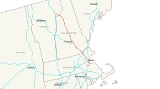
. Its southern terminus is in
CantonCanton is a town in Norfolk County, Massachusetts, United States. The population was 21,561 at the 2010 census. Canton is part of Greater Boston, about 15 miles southwest of downtown Boston.- History :...
,
MassachusettsThe Commonwealth of Massachusetts is a state in the New England region of the northeastern United States of America. It is bordered by Rhode Island and Connecticut to the south, New York to the west, and Vermont and New Hampshire to the north; at its east lies the Atlantic Ocean. As of the 2010...
, in the
BostonBoston is the capital of and largest city in Massachusetts, and is one of the oldest cities in the United States. The largest city in New England, Boston is regarded as the unofficial "Capital of New England" for its economic and cultural impact on the entire New England region. The city proper had...
metropolitan area, at
Interstate 95Interstate 95 is the main highway on the East Coast of the United States, paralleling the Atlantic Ocean from Florida to Maine. The Massachusetts portion of the highway enters from the state of Rhode Island in Attleboro and travels in a northeasterly direction to the junction with Route 128 in...
; its northern terminus is near
St. JohnsburySt. Johnsbury is the shire town of Caledonia County, Vermont, United States. The population was 7,571 at the 2000 census. St. Johnsbury is located approximately northwest of the Connecticut River and south of the Canadian border.St...
,
VermontVermont is a state in the New England region of the northeastern United States of America. The state ranks 43rd in land area, , and 45th in total area. Its population according to the 2010 census, 630,337, is the second smallest in the country, larger only than Wyoming. It is the only New England...
, at
Interstate 91Interstate 91 is an Interstate Highway in the New England region of the United States. It provides the primary north–south thoroughfare in the western part of New England...
. It is one of three mainline Interstate highways whose entire route is located within the New England states, the other two being
I-89Interstate 89 is an interstate highway in the New England region of the United States travelling between Bow, New Hampshire and Highgate Springs, Vermont. As with all odd-numbered primary interstates, I-89 is signed as a north–south highway...
and
I-91Interstate 91 is an Interstate Highway in the New England region of the United States. It provides the primary north–south thoroughfare in the western part of New England...
. The largest cities along its route are
Manchester, New HampshireManchester is the largest city in the U.S. state of New Hampshire, the tenth largest city in New England, and the largest city in northern New England, an area comprising the states of Maine, New Hampshire, and Vermont. It is in Hillsborough County along the banks of the Merrimack River, which...
,
Concord, New HampshireThe city of Concord is the capital of the state of New Hampshire in the United States. It is also the county seat of Merrimack County. As of the 2010 census, its population was 42,695....
and
Boston, MassachusettsBoston is the capital of and largest city in Massachusetts, and is one of the oldest cities in the United States. The largest city in New England, Boston is regarded as the unofficial "Capital of New England" for its economic and cultural impact on the entire New England region. The city proper had...
.
For most of its length, Interstate 93 indirectly parallels
U.S. Route 3U.S. Route 3 is a north–south United States highway that runs from its southern terminus in Cambridge, Massachusetts through New Hampshire to its terminus near Third Connecticut Lake at the Canadian border, where the road continues north as Quebec Route 257.In New Hampshire parts of US 3 are...
. Particularly in
New HampshireNew Hampshire is a state in the New England region of the northeastern United States of America. The state was named after the southern English county of Hampshire. It is bordered by Massachusetts to the south, Vermont to the west, Maine and the Atlantic Ocean to the east, and the Canadian...
, the two highways have several interchanges with each other, as well as a concurrency through
Franconia Notch State ParkFranconia Notch State Park is located in the White Mountains in northern New Hampshire and straddles of Interstate 93 as it passes through Franconia Notch, a mountain pass between the Kinsman Range and Franconia Range...
.
Route description
|-
|MA
|46.19
|74.33
|-
|NH
|131.39
|211.45
|-
|VT
|11.10
|17.86
|-
|Total
|188.68
|303.65
|}
Massachusetts
Interstate 93 begins in the south at exit 12 of
I-95Interstate 95 is the main highway on the East Coast of the United States, paralleling the Atlantic Ocean from Florida to Maine. The Massachusetts portion of the highway enters from the state of Rhode Island in Attleboro and travels in a northeasterly direction to the junction with Route 128 in...
in
CantonCanton is a town in Norfolk County, Massachusetts, United States. The population was 21,561 at the 2010 census. Canton is part of Greater Boston, about 15 miles southwest of downtown Boston.- History :...
. I-93 begins co-signed with
U.S. Route 1U.S. Route 1 is a major north–south U.S. Highway that serves the East Coast of the United States. It runs 2,377 miles from Fort Kent, Maine at the Canadian border south to Key West, Florida. U.S. 1 generally parallels Interstate 95, though it is significantly farther west between...
North. At this junction, I-95 North heads to the northwest (co-signed with
U.S. Route 1U.S. Route 1 is a major north–south U.S. Highway that serves the East Coast of the United States. It runs 2,377 miles from Fort Kent, Maine at the Canadian border south to Key West, Florida. U.S. 1 generally parallels Interstate 95, though it is significantly farther west between...
South, as well as Route 128, which begins at the interchange), to serve as the beltway around Boston, while I-95 South runs by itself southwest through Boston's southwestern suburbs toward
Rhode IslandThe state of Rhode Island and Providence Plantations, more commonly referred to as Rhode Island , is a state in the New England region of the United States. It is the smallest U.S. state by area...
.
The first few miles of I-93 run east through
BostonBoston is the capital of and largest city in Massachusetts, and is one of the oldest cities in the United States. The largest city in New England, Boston is regarded as the unofficial "Capital of New England" for its economic and cultural impact on the entire New England region. The city proper had...
's southern suburbs, passing through
CantonCanton is a town in Norfolk County, Massachusetts, United States. The population was 21,561 at the 2010 census. Canton is part of Greater Boston, about 15 miles southwest of downtown Boston.- History :...
and
RandolphThe Town of Randolph is a city in Norfolk County, Massachusetts, United States. As of the 2010 census, the town population was 32,112. Randolph adopted a new charter effective January 2010 providing for a council-manager form of government instead of the traditional town meeting...
. In Randolph, I-93 meets the northern end of
Route 24Route 24 is a freeway south of I-93 in southeastern Massachusetts, linking Fall River with the Boston metropolitan area. It begins in the south in Fall River at the border with Tiverton, Rhode Island where it connects with Rhode Island Route 24, and runs north to an interchange with Interstate...
(Fall River Expressway/AMVETS Memorial Highway) at Exit 4. I-93 continues east into
BraintreeThe Town of Braintree is a suburban city in Norfolk County, Massachusetts, United States. Although officially known as a town, Braintree adopted a municipal charter, effective 2008, with a mayor-council form of government and is considered a city under Massachusetts law. The population was 35,744...
, interchanging with
Route 3Route 3 is a southward continuation of U.S. Route 3, connecting Cambridge, Massachusetts with Cape Cod. All of it, except for the northernmost end in downtown Boston and Cambridge, is a freeway....
, the major freeway linking Boston to
Cape CodCape Cod, often referred to locally as simply the Cape, is a cape in the easternmost portion of the state of Massachusetts, in the Northeastern United States...
, at Exit 7 (known locally as the "
Braintree SplitThe Braintree Split is the intersection of Interstate 93/U.S. Route 1 and Massachusetts Route 3 located along the city line separating Braintree and Quincy, Massachusetts. The Braintree Split was also the southern end of Route 128 until 1997, when Route 128 was truncated to the I-95/I-93...
"). Route 3 North joins I-93 and US-1, and the highway turns north toward Boston.
Upon turning northward, the highway is known as the Southeast Expressway through
QuincyQuincy is a city in Norfolk County, Massachusetts, United States. Its nicknames are "City of Presidents", "City of Legends", and "Birthplace of the American Dream". As a major part of Metropolitan Boston, Quincy is a member of Boston's Inner Core Committee for the Metropolitan Area Planning Council...
,
MiltonMilton is a town in Norfolk County, Massachusetts, United States and part of the Greater Boston area. The population was 27,003 at the 2010 census. Milton is the birthplace of former U.S. President George H. W. Bush and architect Buckminster Fuller. Milton also has the highest percentage of...
and Boston's
DorchesterDorchester is a dissolved municipality and current neighborhood of Boston, Massachusetts, United States. It is named after the town of Dorchester in the English county of Dorset, from which Puritans emigrated and is today endearingly nicknamed "Dot" by its residents. Dorchester, including a large...
section. After the
Massachusetts AvenueMassachusetts Avenue, known to locals as Mass Ave, is a major thoroughfare in Boston, Massachusetts, and several cities and towns northwest of Boston...
connector exit, the highway officially becomes the John F. Fitzgerald Expressway, which is also known as the
Central ArteryThe John F. Fitzgerald Expressway, known locally as the Central Artery, is a section of freeway in downtown Boston, Massachusetts, designated as Interstate 93, U.S. Route 1 and Route 3. It was initially constructed in the 1950s as a partly elevated and partly tunneled divided highway...
, and passes beneath downtown Boston. A major intersection with the
Massachusetts TurnpikeThe Massachusetts Turnpike is the easternmost stretch of Interstate 90. The Turnpike begins at the western border of Massachusetts in West Stockbridge connecting with the Berkshire Connector portion of the New York State Thruway...
/Interstate 90 (Exit 20) takes place just south of downtown Boston. After the massive interchange, motorists use the
Thomas P. O'Neill Jr. TunnelThe Thomas P. "Tip" O'Neill, Jr. Tunnel is a highway tunnel built as part of the Big Dig in Boston, Massachusetts. It carries the Central Artery underneath downtown Boston, and is numbered as Interstate 93, U.S. Route 1, and Route 3. It roughly follows the route of the old elevated Central Artery,...
to travel underneath the city and then use
Zakim Bunker Hill BridgeThe Leonard P. Zakim Bunker Hill Memorial Bridge is a cable-stayed bridge across the Charles River in Boston, Massachusetts. It is a replacement for the Charlestown High Bridge, an older truss bridge constructed in the 1950s, and is the world's widest cable-stayed bridge...
to cross the
Charles RiverThe Charles River is an long river that flows in an overall northeasterly direction in eastern Massachusetts, USA. From its source in Hopkinton, the river travels through 22 cities and towns until reaching the Atlantic Ocean at Boston...
. Two exits are located in the tunnel, where the speed limit is 45 miles (72.4 km) an hour.
Route 3Route 3 is a southward continuation of U.S. Route 3, connecting Cambridge, Massachusetts with Cape Cod. All of it, except for the northernmost end in downtown Boston and Cambridge, is a freeway....
leaves the Artery just before the Zakim bridge via Exit 26, and
U.S. Route 1U.S. Route 1 is a major north–south U.S. Highway that serves the East Coast of the United States. It runs 2,377 miles from Fort Kent, Maine at the Canadian border south to Key West, Florida. U.S. 1 generally parallels Interstate 95, though it is significantly farther west between...
leaves the Artery just after the bridge, via Exit 27 (no southbound access). From Boston through the rest of Massachusetts,
Concord, NHThe city of Concord is the capital of the state of New Hampshire in the United States. It is also the county seat of Merrimack County. As of the 2010 census, its population was 42,695....
appears as the control city on northbound overhead signs. The Artery ends as I-93 continues north out of the city.
I-93 continues through the northern suburbs of Boston, coming to a second intersection in Woburn with
Interstate 95Interstate 95 is the main highway on the East Coast of the United States, paralleling the Atlantic Ocean from Florida to Maine. The Massachusetts portion of the highway enters from the state of Rhode Island in Attleboro and travels in a northeasterly direction to the junction with Route 128 in...
, and Route 128, which runs congruent. Travelers going north can either change over to I-95 north to eventually reach Maine, or remain on I-93 toward New Hampshire. Farther north, in
AndoverAndover is a town in Essex County, Massachusetts, United States. It was incorporated in 1646 and as of the 2010 census, the population was 33,201...
, I-93 meets
I-495Interstate 495 is the designation of an Interstate Highway half-beltway in Massachusetts. It was the longest auxiliary Interstate Highway of its kind—measuring 120.74 miles —until 1996, when the PA Route 9 section of the Pennsylvania Turnpike was redesignated as Interstate 476, making it about ...
, providing access to
WorcesterWorcester is a city and the county seat of Worcester County, Massachusetts, United States. Named after Worcester, England, as of the 2010 Census the city's population is 181,045, making it the second largest city in New England after Boston....
to the southwest and New Hampshire's
seacoast regionThe Seacoast Region is the southeast area of the U.S. state of New Hampshire. The region stretches 18 miles along the Atlantic Ocean from New Hampshire's border with Salisbury, Massachusetts to the Piscataqua River and New Hampshire's border with Kittery, Maine. The shoreline is generally very...
to the northeast. Just south of the state line, I-93 crosses the
Merrimack RiverThe Merrimack River is a river in the northeastern United States. It rises at the confluence of the Pemigewasset and Winnipesaukee rivers in Franklin, New Hampshire, flows southward into Massachusetts, and then flows northeast until it empties into the Atlantic Ocean at Newburyport...
into
MethuenMethuen is a city in Essex County, Massachusetts, United States. The population was 43,789 at the 2000 census.-History:Methuen was first settled in 1642 and was officially incorporated in 1726; it is named for the British diplomat Sir Paul Methuen. Methuen was originally part of Haverhill,...
, where it interchanges with Route 213, a connector between I-93 and
I-495Interstate 495 is the designation of an Interstate Highway half-beltway in Massachusetts. It was the longest auxiliary Interstate Highway of its kind—measuring 120.74 miles —until 1996, when the PA Route 9 section of the Pennsylvania Turnpike was redesignated as Interstate 476, making it about ...
. I-93 then crosses into
New HampshireNew Hampshire is a state in the New England region of the northeastern United States of America. The state was named after the southern English county of Hampshire. It is bordered by Massachusetts to the south, Vermont to the west, Maine and the Atlantic Ocean to the east, and the Canadian...
.
In all, I-93 has 48 numbered exits in Massachusetts, although several numbers are skipped in and near Boston. One noteworthy reason that some exits were removed from I-93 is to further address traffic problems in addition to converting the Central Artery from six to eight to ten lanes, by reducing the combined number of on- and off-ramps from 27 to 14. Exit 48 in Methuen, just before the New Hampshire state line, is the highest-numbered exit along the entire route. Due to the highway being one of the two major Interstates that enter Boston directly (
Interstate 90Interstate 90 is the longest Interstate Highway in the United States at . It is the northernmost coast-to-coast interstate, and parallels US 20 for the most part. Its western terminus is in Seattle, at Edgar Martinez Drive S. near Safeco Field and CenturyLink Field, and its eastern terminus is in...
is the other), nearly the entire length of the highway in Massachusetts carries four lanes in each direction. Average daily traffic volumes on I-93 in the state range from 100,000 vehicles at the New Hampshire border and 150,000 vehicles at the southern end at I-95 to over 200,000 vehicles through Braintree and Quincy.
New Hampshire
Interstate 93 travels just over 131 miles (210.8 km) in the Granite State; around two-thirds of the highway's total distance. Serving as the main interstate route in New Hampshire, it connects the state capital,
ConcordThe city of Concord is the capital of the state of New Hampshire in the United States. It is also the county seat of Merrimack County. As of the 2010 census, its population was 42,695....
, and its largest city,
ManchesterManchester is the largest city in the U.S. state of New Hampshire, the tenth largest city in New England, and the largest city in northern New England, an area comprising the states of Maine, New Hampshire, and Vermont. It is in Hillsborough County along the banks of the Merrimack River, which...
. Beyond Concord are the towns of
TiltonTilton is a town located on the Winnipesaukee River in Belknap County, New Hampshire, United States. The population was 3,567 at the 2010 census. It includes the village of Lochmere. Tilton is home to the Tilton School, a private preparatory school.-History:...
,
PlymouthPlymouth is a town in Grafton County, New Hampshire, United States, in the White Mountains Region. Plymouth is located at the convergence of the Pemigewasset and Baker rivers. The population was 6,990 at the 2010 census...
, and
LittletonLittleton is a town in Grafton County, New Hampshire, United States. The population was 5,928 at the 2010 census. Situated at the edge of the White Mountains, Littleton is bounded on the northwest by the Connecticut River....
. I-93 is known as the Alan B. Shepard Highway from the Massachusetts line to
HooksettHooksett is a town in Merrimack County, New Hampshire, United States. The population was 13,451 at the 2010 census. The town is located between Manchester, the state's largest city, and Concord, the state capital...
(just north of Manchester), as the F.E. Everett Turnpike from Hooksett to Concord, and as the
Styles BridgesHenry Styles Bridges was an American teacher, editor, and Republican Party politician from Concord, New Hampshire. He served one term as 63rd Governor of New Hampshire before a twenty-four year career in the United States Senate.Bridges was born in West Pembroke, Maine. He attended the public...
Highway from Concord to the Vermont line.
Between the northern end of
I-293Interstate 293 is an long loop surrounding Manchester, New Hampshire, USA roughly shaped like two sides of a triangle. Completing the loop in the northeast is Interstate 93. The southern portion of the loop shares the road with NH 101 and passes near Manchester-Boston Regional Airport and the...
in Hooksett and the beginning of
I-89Interstate 89 is an interstate highway in the New England region of the United States travelling between Bow, New Hampshire and Highgate Springs, Vermont. As with all odd-numbered primary interstates, I-89 is signed as a north–south highway...
in
BowBow is a town in Merrimack County, New Hampshire, United States. The population was 7,519 at the 2010 census.- History :Incorporated in 1727, the town was one of several formed to ease population pressures on the Seacoast. The town's name comes from its establishment along a bend, or "bow", in the...
, I-93 also carries the northern end of the
Everett TurnpikeThe Frederick E. Everett Turnpike, also called the Central New Hampshire Turnpike, is a toll road in New Hampshire, USA, running from the Massachusetts border at Nashua north to Concord...
. There is one toll booth along this section, at Exit 11 in Hooksett; toll for passenger cars is currently $1 (50¢ at the ramp toll booth). This is the only toll collected along the entire length of Interstate 93. I-93 in New Hampshire is also notable for having state liquor stores serve as rest areas, which are passed just after the toll plaza, traveling north. There are separate stores on both sides of the Interstate for travelers in each direction.
I-93 enters New Hampshire at
SalemSalem is a town in Rockingham County, New Hampshire, United States. The population was 28,776 at the 2010 census. Salem is a marketing and distributing center north of Boston, with a major amusement attraction, Canobie Lake Park, and a large shopping mall, the Mall at Rockingham Park.- History :The...
, where the current reconstruction of the Exit 1 ramps (leading to
the Mall at Rockingham ParkThe Mall at Rockingham Park is located in Salem, New Hampshire. It is the largest shopping mall in New Hampshire, as well as northern New England, with of floor space. The mall is adjacent to the Rockingham Park race track in Salem, and was the state's third shopping mall to be built...
) along with the reduction of the freeway from 4 northbound lanes to only 2 tends to cause traffic backups. A rest area/welcome center is available on the northbound side of the freeway, directly before Exit 1. I-93 remains only two lanes wide in each direction for its first 18 miles (29 km), until the split with
Interstate 293Interstate 293 is an long loop surrounding Manchester, New Hampshire, USA roughly shaped like two sides of a triangle. Completing the loop in the northeast is Interstate 93. The southern portion of the loop shares the road with NH 101 and passes near Manchester-Boston Regional Airport and the...
and the junction with
New Hampshire Route 101New Hampshire Route 101 is a state-maintained highway in southern New Hampshire extending from Keene to Hampton Beach. It is the major east–west highway in the southern portion of the state....
add a third and fourth lane back to the freeway. I-93 and New Hampshire Route 101 run concurrently for about a mile before New Hampshire Route 101 heads directly east as its own freeway, serving Portsmouth and the Seacoast region. I-93 keeps three lanes of traffic in each direction until the junction with
Interstate 89Interstate 89 is an interstate highway in the New England region of the United States travelling between Bow, New Hampshire and Highgate Springs, Vermont. As with all odd-numbered primary interstates, I-89 is signed as a north–south highway...
, when each side reduces back to two, and remains a four-lane freeway through most of its journey northward, with the only exception being the
Franconia NotchFranconia Notch is a major mountain pass through the White Mountains of New Hampshire. Dominated by Cannon Mountain, it lies principally within Franconia Notch State Park and is traversed by the Franconia Notch Parkway Franconia Notch (el. 1950 ft. / 590 m.) is a major mountain pass through...
section.
It crosses the
Merrimack RiverThe Merrimack River is a river in the northeastern United States. It rises at the confluence of the Pemigewasset and Winnipesaukee rivers in Franklin, New Hampshire, flows southward into Massachusetts, and then flows northeast until it empties into the Atlantic Ocean at Newburyport...
again before going through the state capital of
ConcordThe city of Concord is the capital of the state of New Hampshire in the United States. It is also the county seat of Merrimack County. As of the 2010 census, its population was 42,695....
. In Concord,
Interstate 393Interstate 393 is a spur extending east from Interstate 93 at Concord, New Hampshire, USA. The primary purpose of the road is to bypass a densely-built commercial strip on Route 9 in the eastern part of Concord. Several times a year, I-393 also serves traffic to events at New Hampshire Motor...
heads directly east (co-signed with eastbound
U.S. Route 4U.S. Route 4 is a long United States highway that runs from East Greenbush, New York, in the west to Portsmouth, New Hampshire, in the east, traversing through Vermont.In New York, US 4 is signed north–south to reflect its alignment in the state...
and
U.S. Route 202U.S. Route 202 is a highway stretching from Delaware to Maine, also passing through the states of Pennsylvania, New Jersey, New York, Connecticut, Massachusetts, and New Hampshire....
), providing another route to the Seacoast region. Westbound U.S. Route 4 joins I-93 and runs concurrently with it until Exit 17 for Penacook, about 5 miles (8 km) further north, before exiting westward. Continuing north, I-93 traverses the
Lake WinnipesaukeeLake Winnipesaukee is the largest lake in the U.S. state of New Hampshire. It is approximately long and from wide , covering — when Paugus Bay is included—with a maximum depth of ....
tourist region and makes its way north through the heart of the
White Mountains RegionThe White Mountains Region is a tourism region designated by the New Hampshire Division of Travel and Tourism. It is located in northern New Hampshire in the United States and is named for the White Mountains, which cover most of the region. The southern boundary of the region begins at Piermont...
. I-93 passes through
Franconia Notch State ParkFranconia Notch State Park is located in the White Mountains in northern New Hampshire and straddles of Interstate 93 as it passes through Franconia Notch, a mountain pass between the Kinsman Range and Franconia Range...
as a
Super-2A super two, super two-lane highway or wide two lane is a two-lane surface road built to high standards, typically including partial control of access, occasional passing lanes and hard shoulders...
parkway. This stretch carries a 45-mile-per-hour speed limit. For the trip through Franconia Notch, I-93 and
U.S. Route 3U.S. Route 3 is a north–south United States highway that runs from its southern terminus in Cambridge, Massachusetts through New Hampshire to its terminus near Third Connecticut Lake at the Canadian border, where the road continues north as Quebec Route 257.In New Hampshire parts of US 3 are...
run concurrently.
Beyond Franconia Notch State Park, U.S. 3 heads northeastward through the
Great North Woods regionThe Great North Woods Region is located at the northern tip of New Hampshire, U.S.A., north of the White Mountains Region. The Great North Woods is a tourism region of New Hampshire and is located in Coos County...
, while I-93 runs to the northwest. The final town along I-93 in New Hampshire is
LittletonLittleton is a town in Grafton County, New Hampshire, United States. The population was 5,928 at the 2010 census. Situated at the edge of the White Mountains, Littleton is bounded on the northwest by the Connecticut River....
, served by three exits. Many motorist services are available at Exit 42. After passing through town, it crosses the
Connecticut RiverThe Connecticut River is the largest and longest river in New England, and also an American Heritage River. It flows roughly south, starting from the Fourth Connecticut Lake in New Hampshire. After flowing through the remaining Connecticut Lakes and Lake Francis, it defines the border between the...
into
VermontVermont is a state in the New England region of the northeastern United States of America. The state ranks 43rd in land area, , and 45th in total area. Its population according to the 2010 census, 630,337, is the second smallest in the country, larger only than Wyoming. It is the only New England...
. The last exit along I-93 is exit 44 for
MonroeMonroe is a town in Grafton County, New Hampshire, United States. The population was 788 at the 2010 census. The town is located along a bend of the Connecticut River, across from Barnet, Vermont...
, through which a rest area/welcome center is accessible to travelers on both sides of the highway.
Vermont
Interstate 93 runs for only 11 miles (17.7 km) in
VermontVermont is a state in the New England region of the northeastern United States of America. The state ranks 43rd in land area, , and 45th in total area. Its population according to the 2010 census, 630,337, is the second smallest in the country, larger only than Wyoming. It is the only New England...
, with only one numbered exit in the state before ending at the interchange with
Interstate 91Interstate 91 is an Interstate Highway in the New England region of the United States. It provides the primary north–south thoroughfare in the western part of New England...
in St. Johnsbury. A rest area/welcome center is located along the northbound side of the highway for travelers entering from New Hampshire. The final few miles of the Interstate, just before its terminus, actually veer to the southwest. Vehicles bound for Canada can use northbound I-91 to reach the
QuebecQuebec or is a province in east-central Canada. It is the only Canadian province with a predominantly French-speaking population and the only one whose sole official language is French at the provincial level....
border crossing at that Interstate's end. The portion of I-93 in Vermont parallels both
U.S. Route 2U.S. Route 2 is an east–west U.S. Highway spanning across the northern continental United States. US 2 consists of two segments connected by various roadways in southern Canada...
and
Vermont Route 18Vermont Route 18 is a state highway in Caledonia County, Vermont, United States. It runs southeast from the town of St. Johnsbury to the New Hampshire state line, continuing there as New Hampshire Route 18...
.
Southeast Expressway
The Southeast Expressway in and near Boston was constructed between 1954 and 1959, at the same time the Fitzgerald Expressway (Central Artery) was built. It begins at the
Braintree SplitThe Braintree Split is the intersection of Interstate 93/U.S. Route 1 and Massachusetts Route 3 located along the city line separating Braintree and Quincy, Massachusetts. The Braintree Split was also the southern end of Route 128 until 1997, when Route 128 was truncated to the I-95/I-93...
and ends at the
Thomas P. O'Neill Jr. TunnelThe Thomas P. "Tip" O'Neill, Jr. Tunnel is a highway tunnel built as part of the Big Dig in Boston, Massachusetts. It carries the Central Artery underneath downtown Boston, and is numbered as Interstate 93, U.S. Route 1, and Route 3. It roughly follows the route of the old elevated Central Artery,...
. A section of the Expressway, beginning south of the Savin Hill overpass and ending just before the junction with
Route 3Route 3 is a southward continuation of U.S. Route 3, connecting Cambridge, Massachusetts with Cape Cod. All of it, except for the northernmost end in downtown Boston and Cambridge, is a freeway....
, utilizes a zipper lane, in which a movable barrier carves out a reversible high occupancy vehicle lane on the non-peak side of the highway during
rush hourA rush hour or peak hour is a part of the day during which traffic congestion on roads and crowding on public transport is at its highest. Normally, this happens twice a day—once in the morning and once in the evening, the times during when the most people commute...
.
Boston
The Central Artery, officially the John F. Fitzgerald Expressway, was a section of highway in downtown Boston constructed in the 1950s and was originally designed as a fully elevated highway. This new highway was greatly disliked by the citizens of the city because it cut the heart of the city in half, cast long, dreary shadows and was an eyesore to the community. Because of the public outcry, Gov. John Volpe ordered the southern half of the highway redesigned so that it was underground; this section became known as the
Dewey Square TunnelThe Dewey Square Tunnel in Boston, Massachusetts, is part of Interstate 93 , running under the heart of the city's financial district, including Dewey Square...
. With the cancellation of the highway projects leading into the city in 1972 by Gov.
Francis W. SargentFrancis William Sargent was the 64th Governor of Massachusetts from 1969 to 1975. Born in 1915 in Hamilton, Massachusetts, he was known for his sharp wit and self-deprecating manner...
, the Central Artery gained the designation of Interstate 93 in 1974. It has also carried the local highway designations of U.S. 1 (since 1989) and
Route 3Route 3 is a southward continuation of U.S. Route 3, connecting Cambridge, Massachusetts with Cape Cod. All of it, except for the northernmost end in downtown Boston and Cambridge, is a freeway....
.
By the mid-1970s, I-93 had outgrown its capacity and had begun to deteriorate due a lack of maintenance. State Transportation Secretary
Frederick P. SalvucciFrederick Peter Salvucci is a civil engineer specializing in transportation, in particular infrastructure, urban transportation, public transportation and institutional development in decision-making. He was the Secretary of Transportation for the Commonwealth of Massachusetts under Governor...
, aware of the issues surrounding the elevated roadway, proposed a plan conceived in the early 1970s by the
Boston Transportation Planning ReviewBoston Transportation Planning Review is a transportation planning program for metropolitan Boston, United States which was responsible for analyzing and re-designing the entire area-wide transit and highway system in the 1970s. The major contractors involved were Alan M...
to replace the rusting elevated six-lane Central Artery with a new, more efficient underground roadway. This plan was merged with a long-standing proposal to build a third harbor tunnel to alleviate congestion in the
SumnerThe Sumner Tunnel is a road tunnel in Boston, Massachusetts, USA. It carries traffic under Boston Harbor in one direction, from Logan International Airport and Route 1A in East Boston. The tunnel originally deposited traffic at the west side of the North End but with the completion of the Big Dig,...
and
CallahanThe Callahan Tunnel, officially the Lieutenant William F. Callahan Tunnel is one of four tunnels beneath Boston Harbor in Boston, Massachusetts. It carries motor vehicles from the North End to Logan International Airport and Route 1A in East Boston...
tunnels to East Boston; the new plan became known as the Central Artery/Tunnel Project or the
Big Dig.
These new roadways were built during a twelve-year period from 1994 to early 2006. The massive project became the largest urban construction project ever undertaken in American history. Construction on the new I-93 segment was not without serious issues: a lengthly Federal environmental review pushed the start of construction back from approximately 1990, causing many inflationary increases; funding for the project was the subject of several political battles between Pres.
Ronald ReaganRonald Wilson Reagan was the 40th President of the United States , the 33rd Governor of California and, prior to that, a radio, film and television actor....
and Rep. Thomas P. O'Neill, Jr. Major construction on the new roadway was done while maintaining the old roadway, a step that also greatly increased the cost of the project. The original
Charles RiverThe Charles River is an long river that flows in an overall northeasterly direction in eastern Massachusetts, USA. From its source in Hopkinton, the river travels through 22 cities and towns until reaching the Atlantic Ocean at Boston...
crossing, named Scheme Z, was the object to great public outcry similar to that of the building of the original highway. The outcry eventually led to the replacement of Scheme Z with a newer, more sleek
cable-stayed bridgeA cable-stayed bridge is a bridge that consists of one or more columns , with cables supporting the bridge deck....
and complementing exit for
CambridgeCambridge is a city in Middlesex County, Massachusetts, United States, in the Greater Boston area. It was named in honor of the University of Cambridge in England, an important center of the Puritan theology embraced by the town's founders. Cambridge is home to two of the world's most prominent...
, increasing the cost even more.
In Downtown Boston, I-93 is now made up of the
Thomas P. O'Neill Jr. TunnelThe Thomas P. "Tip" O'Neill, Jr. Tunnel is a highway tunnel built as part of the Big Dig in Boston, Massachusetts. It carries the Central Artery underneath downtown Boston, and is numbered as Interstate 93, U.S. Route 1, and Route 3. It roughly follows the route of the old elevated Central Artery,...
and the
Zakim Bunker Hill BridgeThe Leonard P. Zakim Bunker Hill Memorial Bridge is a cable-stayed bridge across the Charles River in Boston, Massachusetts. It is a replacement for the Charlestown High Bridge, an older truss bridge constructed in the 1950s, and is the world's widest cable-stayed bridge...
, which spans the Charles River. The underground construction of the tunnel system was completed as of October, 2006; however, repairs continue to many parts of the tunnel due to water leakage because of improper construction of the
slurry wallA slurry wall is a technique used to build reinforced-concrete walls in areas of soft earth close to open water or with a high ground water table. This technique is typically used to build diaphragm walls surrounding tunnels and open cuts, and to lay foundations.A trench is excavated to create a...
s supporting the O'Neill tunnel. The former route of the above-ground Artery, so named "the other
Green MonsterThe Green Monster is a popular nickname for the thirty-seven foot , two-inch high left field wall at Fenway Park, home to the Boston Red Sox baseball team...
" by Mayor
Thomas MeninoThomas Michael "Tom" Menino is the mayor of Boston, Massachusetts, United States and the city's first Italian-American mayor...
, was replaced mostly by open space known formally as the
Rose Kennedy GreenwayThe Rose Kennedy Greenway is a roughly 1.5-mile-long long series of parks and public spaces being created in downtown Boston, Massachusetts, USA. It is the final part of the Big Dig that put Interstate 93 underground and removed the elevated freeway that served as the main highway through downtown...
.
Additional improvements were done in the
South BaySouth Bay is a 10-acre site in Boston, Massachusetts sandwiched between Chinatown and the Leather District. It is roughly bounded by Kneeland Street, Hudson Street, the Massachusetts Turnpike mainline, and the Interstate 93 mainline. Currently owned by the Massachusetts Turnpike Authority , the...
section of the highway: The I-90/I-93 interchange was completely redesigned, a new HOV lane extending from the zipper lane in Quincy was added and the South Boston Haul road that was constructed to bypass truck traffic around residential streets in the South End is now open to general traffic.
Hazardous cargoes are now prohibited from I-93 in Boston due to safety issues in the tunnels; these cargoes must now exit at either the
Leverett CircleLeverett Circle is an intersection in Boston, Massachusetts. Completely rebuilt during the Big Dig, it is no longer a rotary. It marks the confluence of Storrow Drive, Charles River Dam Road, Nashua Street, Charles Street, and Martha Road....
connector in Cambridge when traveling southbound or at the Massachusetts Ave. exit when traveling northbound.
Northern Expressway
The Northern Expressway was constructed from
MedfordMedford is a city in Middlesex County, Massachusetts, in the United States, on the Mystic River, five miles northwest of downtown Boston. In the 2010 U.S. Census, Medford's population was 56,173...
to the New Hampshire border between 1956 and 1963. It was extended through
SomervilleSomerville is a city in Middlesex County, Massachusetts, United States, located just north of Boston. As of the 2010 census, the city had a total population of 75,754 and was the most densely populated municipality in New England. It is also the 17th most densely populated incorporated place in...
and
CharlestownCharlestown is a neighborhood of Boston, Massachusetts, United States, and is located on a peninsula north of downtown Boston. Charlestown was originally a separate town and the first capital of the Massachusetts Bay Colony; it became a city in 1847 and was annexed by Boston on January 5, 1874...
to the
Central ArteryThe John F. Fitzgerald Expressway, known locally as the Central Artery, is a section of freeway in downtown Boston, Massachusetts, designated as Interstate 93, U.S. Route 1 and Route 3. It was initially constructed in the 1950s as a partly elevated and partly tunneled divided highway...
,
U.S. Route 1U.S. Route 1 is a major north–south U.S. Highway that serves the East Coast of the United States. It runs 2,377 miles from Fort Kent, Maine at the Canadian border south to Key West, Florida. U.S. 1 generally parallels Interstate 95, though it is significantly farther west between...
, and the planned route of the Inner Belt between 1965 and 1973. Because it was already under construction, the highway was granted an exception to the moratorium on highway expansion inside Route 128 which was announced in 1970.
New Hampshire
Originally planned to follow the alignment of US 3 through
Nashua-Climate:-Demographics:As of the census of 2010, there were 86,494 people, 35,044 households, and 21,876 families residing in the city. The population density was 2,719.9 people per square mile . There were 37,168 housing units at an average density of 1,202.8 per square mile...
along the
Everett TurnpikeThe Frederick E. Everett Turnpike, also called the Central New Hampshire Turnpike, is a toll road in New Hampshire, USA, running from the Massachusetts border at Nashua north to Concord...
, this was changed before construction to the current route through
SalemSalem is a town in Rockingham County, New Hampshire, United States. The population was 28,776 at the 2010 census. Salem is a marketing and distributing center north of Boston, with a major amusement attraction, Canobie Lake Park, and a large shopping mall, the Mall at Rockingham Park.- History :The...
largely due to the intervention of the owners of
Rockingham ParkRockingham Park is a horse racing establishment in Salem, New Hampshire, in the United States. First built in 1906, it was used as an area for many to gamble on the weekends. Seabiscuit raced there in 1935 and 1936, and Mom's Command ran in her first race and gained her first victory there in...
. Exit 1 in Salem was originally designed and built with ramps allowing northbound traffic to exit to the race track and return drivers to southbound 93 only. The complementary ramps were added much later, with the southbound off ramp being a particularly tight and dangerous turn squeezed within the curve of the southbound on ramp.
An 8 miles (13 km) section of I-93 through
Franconia Notch State ParkFranconia Notch State Park is located in the White Mountains in northern New Hampshire and straddles of Interstate 93 as it passes through Franconia Notch, a mountain pass between the Kinsman Range and Franconia Range...
, called the
Franconia Notch Parkway in New Hampshire, was constructed as a
two-lane freewayA two-lane expressway is an expressway with only one lane in each direction, and usually no median barrier. It may be built that way because of constraints, or may be intended for expansion once traffic volumes rise. The term super two is often used by roadgeeks for this type of road, but traffic...
with a median divider. This was built as a compromise between the state's park department and highway officials. The speed limit on the Parkway is 45 mph (70 km/h). Originally, this section's signage read "U.S. 3 TO I-93" in this area complete with its own exit number sequence, but this has since been replaced by I-93 and
US-3U.S. Route 3 is a north–south United States highway that runs from its southern terminus in Cambridge, Massachusetts through New Hampshire to its terminus near Third Connecticut Lake at the Canadian border, where the road continues north as Quebec Route 257.In New Hampshire parts of US 3 are...
signage along the entire length of the Parkway. The exits were renumbered to Exit 34A, 34B, and 34C.
A 59-vehicle accident briefly closed the turnpike near
Derry-Climate:-Demographics:As of the census of 2010, there were 33,109 people, 12,537 households, and 8,767 families residing in the town. The population density was 924.8 people per square mile . There were 13,277 housing units at an average density of 143.2/km²...
, Exit 4, on January 11, 2009. A bus had tried to avoid a car going out of control. There were no major injuries. A 12-vehicle accident occurred the following Sunday, January 18, near the previous week's accident. The pair of accidents has led proponents of widening the highway to urge that there be no more delays in the project.
Vermont
Construction of Interstate 93 was completed in 1983 in Vermont. It was the last interstate to be built in the state.
Massachusetts plans
Since 1996, MassHighway has studied rebuilding the intersection of I-93 and I-95 in
WoburnWoburn is a city in Middlesex County, Massachusetts, USA. The population was 38,120 at the 2010 census. Woburn is located north of Boston, Massachusetts, and just south of the intersection of I-93 and I-95.- History :...
along the border with
StonehamStoneham is a town in Middlesex County, Massachusetts. Its population was 21,437 at the 2010 census, down from 22,219 in 2000. The town is the birthplace of Olympic figure skating medalist Nancy Kerrigan and is the home of the Stone Zoo.- History :...
and
ReadingReading is an affluent town situated in Middlesex County, Massachusetts, United States, some north of central Boston. The population was 24,747 at the 2010 census.-Settlement and Independence:...
. The project is expected to start in 2017 and cost $267 million.
The Massachusetts Department of Transportation and its predecessor MassHighway have planned on widening I-93 to a uniform four travel lanes in both directions from the current lane drop near Exit 41 in
WilmingtonWilmington is a town in Middlesex County, Massachusetts, United States. The population was 22,325 at the 2010 census.-History:Wilmington was first settled in 1665 and was officially incorporated in 1730, from parts of Woburn, Reading and Billerica. Minutemen from Wilmington responded to the alarm...
to the New Hampshire border since the beginning of the 2000s. The first section of widening will be done as part of the I-93 Tri-Town Interchange Project. The project will construct a new interchange in Wilmington. I-93 will be widened from 3 to 4 lanes from Exit 41 to I-495, a distance of approximately 5 miles (8 km), as the first phase in widening I-93 from Exit 41 to the New Hampshire state line. Early estimates of the entire project place the cost at $567 million.
Rapid bridge replacement project
In September 2010, a section of a bridge in
MedfordMedford is a city in Middlesex County, Massachusetts, in the United States, on the Mystic River, five miles northwest of downtown Boston. In the 2010 U.S. Census, Medford's population was 56,173...
when a 25 foot section of bridge deck on the northbound side partially collapsed due to age-related structural fatigue. The collapse forced the Massachusetts Department of Transportation to evaluate the remaining bridges along the corridor, eventually deciding to replace several bridges along the highway in a plan called 93 Fast 14. MassDOT set in motion a plan to replace the superstructure and concrete decks on 14 overpass bridges along that section of the interstate. The $98.1 million project replaced bridges originally built in 1957 with a set of prefabricated modular concrete bridges in a series of weekend roadway closures. Traffic was diverted into a series of crossover lanes during construction. The main part of the project took place each weekend from June through August 2011,with the exception of the July 4th holiday weekend. One or two bridges were replaced each weekend during the construction time frame. The project was part of the Commonwealth's Accelerated Bridge Program.
New Hampshire plans
Initial plans to widen I-93 to a uniform four travel lanes in both directions from
SalemSalem is a town in Rockingham County, New Hampshire, United States. The population was 28,776 at the 2010 census. Salem is a marketing and distributing center north of Boston, with a major amusement attraction, Canobie Lake Park, and a large shopping mall, the Mall at Rockingham Park.- History :The...
to
ManchesterManchester is the largest city in the U.S. state of New Hampshire, the tenth largest city in New England, and the largest city in northern New England, an area comprising the states of Maine, New Hampshire, and Vermont. It is in Hillsborough County along the banks of the Merrimack River, which...
beginning in 2008 were put on hold due to a lawsuit designed to force the
NH Department of TransportationThe State of New Hampshire Department of Transportation is a government agency of the U.S. state of New Hampshire. The NHDOT is under the executive direction of Commissioner of Transportation George Campbell. The main office of the NHDOT is located in the J.O...
to update the plans to include other transportation options. Under orders from US District Court, the NHDOT and US Department of Transportation must provide an updated environmental review. The
Conservation Law FoundationConservation Law Foundation is an environmental advocacy organization based in New England. Since 1966, CLF's mission has been to advocate on behalf of the region's environment and its communities. CLF's advocacy work takes place in four program areas: Clean Energy & Climate Change, Clean Water &...
(CLF) filed a lawsuit in February 2006, hoping to force any expansion plans in the area to include the restoration of commuter rail service between Manchester and Boston. Despite the suit, the Exit 1 interchange construction was allowed to undergo upgrading and expansion; other associated projects related to the widening, chiefly around Exits 3 and 5, were also eventually allowed to proceed. The whole set of projects were eventually allowed to move forward when an agreement between the state and the CLF that removed the group's opposition to construction which does not pose a threat to the environment.
As part of the
2009 stimulus packageThe American Recovery and Reinvestment Act of 2009, abbreviated ARRA and commonly referred to as the Stimulus or The Recovery Act, is an economic stimulus package enacted by the 111th United States Congress in February 2009 and signed into law on February 17, 2009, by President Barack Obama.To...
, New Hampshire is set to receive several million dollars in highway construction funds. One of the projects will be widening a portion of the highway between the Massachusetts border and Manchester. Bidding is set to begin in February 2009 with construction slated to begin in late 2009 or early 2010. The plans call for the New Hampshire Department of Transportation to widen the southernmost 20 miles (32.2 km) of I-93 to four lanes in each direction, from the current two. In addition, all five interchanges along this length will be upgraded to accommodate larger amounts of traffic, including replacing many aging bridges. Smaller construction projects at some of the interchanges are already taking place. According to plans filed by the state with US DOT, the project is scheduled to run from 2009 through 2016, with work starting at the Massachusetts line and moving northward to Manchester. The project is designed with an intermodal transit bent; new or improved park and ride facilities deployed at exits 1, 3 and 5 and a widened median strip that is designed to accommodate a planned commuter rail service between Boston and Manchester.
As a way to help defray the costs of the expansion, in early 2010 the NHDOT made a formal request to the
Federal Highway AdministrationThe Federal Highway Administration is a division of the United States Department of Transportation that specializes in highway transportation. The agency's major activities are grouped into two "programs," the Federal-aid Highway Program and the Federal Lands Highway Program...
to add tolls to I-93 at the Massachusetts-New Hampshire border. The new toll facility was to be located in Salem, New Hampshire, approximately 0.5 mi (0.80467 km) from the state line, and would cost travelers $2 per car. The proposal faced opposition from state legislators in both states who claimed the tolls would cause severe congestion in the area and lead to an economic burden to local residents. Opponents included US senator
Scott BrownScott Brown is a United States senator.Scott Brown may also refer to:-Sportsmen:*Scott Brown , American college football coach of Kentucky State...
(
RThe Republican Party is one of the two major contemporary political parties in the United States, along with the Democratic Party. Founded by anti-slavery expansion activists in 1854, it is often called the GOP . The party's platform generally reflects American conservatism in the U.S...
-Massachusetts). The proposal was eventually dropped in favor of issuing new state bonds to pay for expansion. The new policy was laid out by Transportation Commissioner George Campbell after reviewing the proposal and receiving a promise from the MassDOT that it would not be enacting a similar toll on the Massachusetts side of the border.
Exit list
Exits 17, 19, 21 & 25 were eliminated as part of the Big Dig.
{| class="wikitable"
!County
!Location
!Mile
!
#An exit number is a number assigned to a road junction, usually an exit from a freeway. It is usually marked on the same sign as the destinations of the exit, as well as a sign in the gore....
!Destinations
!Notes
|-
|rowspan=14|Norfolk
|rowspan=3|
CantonCanton is a town in Norfolk County, Massachusetts, United States. The population was 21,561 at the 2010 census. Canton is part of Greater Boston, about 15 miles southwest of downtown Boston.- History :...
|0.00
|
|bgcolor=#ddffdd|, Portsmouth
|bgcolor=#ddffdd|I-93's southern terminus and southern end of US 1 concurrency.
The mainline of I-93 South defaults onto I-95 North. US 1 South continues concurrent with I-95 North and Route 128 North begins at this interchange.
|-
|0.24
|1
|bgcolor=#ffdddd| - Providence
|bgcolor=#ffdddd|Southbound exit and northbound entrance
|-
|1.41
|2A-B
|
|
|-
|
MiltonMilton is a town in Norfolk County, Massachusetts, United States and part of the Greater Boston area. The population was 27,003 at the 2010 census. Milton is the birthplace of former U.S. President George H. W. Bush and architect Buckminster Fuller. Milton also has the highest percentage of...
|2.59
|3
|Ponkapoag Trail -
Houghton's PondHoughton's Pond is a spring-fed kettle hole pond in Milton, Massachusetts, south of Boston. Like many ponds and lakes in the United States, it was formed by receding glaciers about 10,000 years ago...
|
|-
|rowspan=2|
RandolphThe Town of Randolph is a city in Norfolk County, Massachusetts, United States. As of the 2010 census, the town population was 32,112. Randolph adopted a new charter effective January 2010 providing for a council-manager form of government instead of the traditional town meeting...
|3.45
|4
|
|Fall River Expressway/Amvets Highway
|-
|4.22
|5A-B
|
|
|-
|rowspan=2|
BraintreeThe Town of Braintree is a suburban city in Norfolk County, Massachusetts, United States. Although officially known as a town, Braintree adopted a municipal charter, effective 2008, with a mayor-council form of government and is considered a city under Massachusetts law. The population was 35,744...
|6.43
|6
|
|
|-
|7.07
|7
|bgcolor=#ddffdd|
|bgcolor=#ddffdd|Route 3 enters northbound and exits southbound
|-
|
QuincyQuincy is a city in Norfolk County, Massachusetts, United States. Its nicknames are "City of Presidents", "City of Legends", and "Birthplace of the American Dream". As a major part of Metropolitan Boston, Quincy is a member of Boston's Inner Core Committee for the Metropolitan Area Planning Council...
|8.20
|8
|
Furnace Brook ParkwayFurnace Brook Parkway is a historic parkway in Quincy, Massachusetts. Part of the Metropolitan Park System of Greater Boston, it serves as a connector between the Blue Hills Reservation and Quincy Shore Reservation at Quincy Bay...
-
QuincyQuincy is a city in Norfolk County, Massachusetts, United States. Its nicknames are "City of Presidents", "City of Legends", and "Birthplace of the American Dream". As a major part of Metropolitan Boston, Quincy is a member of Boston's Inner Core Committee for the Metropolitan Area Planning Council...
|
|-
|rowspan=5|
MiltonMilton is a town in Norfolk County, Massachusetts, United States and part of the Greater Boston area. The population was 27,003 at the 2010 census. Milton is the birthplace of former U.S. President George H. W. Bush and architect Buckminster Fuller. Milton also has the highest percentage of...
|9.31
|9
|bgcolor=#ffdddd|Bryant Avenue - West Quincy
|bgcolor=#ffdddd|Southbound exit and northbound entrance
|-
|9.38
|9
|bgcolor=#ffdddd|Adams Street -
MiltonMilton is a town in Norfolk County, Massachusetts, United States and part of the Greater Boston area. The population was 27,003 at the 2010 census. Milton is the birthplace of former U.S. President George H. W. Bush and architect Buckminster Fuller. Milton also has the highest percentage of...
,
North QuincyNorth Quincy is a neighborhood of Quincy, Massachusetts. It is separated from the city of Boston by the Neponset River, and borders the Quincy neighborhoods of Squantum, Montclair and Wollaston...
|bgcolor=#ffdddd|Northbound exit and southbound entrance
|-
|9.59
|10
|bgcolor=#ffdddd|Squantum Street -
MiltonMilton is a town in Norfolk County, Massachusetts, United States and part of the Greater Boston area. The population was 27,003 at the 2010 census. Milton is the birthplace of former U.S. President George H. W. Bush and architect Buckminster Fuller. Milton also has the highest percentage of...
|bgcolor=#ffdddd|Southbound exit only
|-
|10.84
|11A
|bgcolor=#ffdddd|Granite Avenue - East Milton
|bgcolor=#ffdddd|Southbound exit and northbound entrance
|-
|10.84
|11B
|bgcolor=#ffdddd|
|bgcolor=#ffdddd|Signed as exit 11 northbound; no northbound entrance
|-
|rowspan=15|Suffolk
|rowspan=15|
BostonBoston is the capital of and largest city in Massachusetts, and is one of the oldest cities in the United States. The largest city in New England, Boston is regarded as the unofficial "Capital of New England" for its economic and cultural impact on the entire New England region. The city proper had...
|11.72
|12
|bgcolor=#ffdddd|
|bgcolor=#ffdddd|Southbound exit and northbound entrance
|-
|12.61
|13
|bgcolor=#ffdddd|Freeport Street -
DorchesterDorchester is a dissolved municipality and current neighborhood of Boston, Massachusetts, United States. It is named after the town of Dorchester in the English county of Dorset, from which Puritans emigrated and is today endearingly nicknamed "Dot" by its residents. Dorchester, including a large...
|bgcolor=#ffdddd|Northbound exit and southbound entrance
|-
|12.84
|14
|bgcolor=#ffdddd|
Morrissey BoulevardMorrissey Boulevard is a six-lane divided coastal road in the Dorchester neighborhood of Boston, Massachusetts. It is owned and maintained by the Massachusetts Department of Conservation and Recreation .- Route description :...
- JFK Library
|bgcolor=#ffdddd|Northbound exit and southbound entrance
|-
|14.36
|15
|Columbia Road -
Edward Everett SquareEdward Everett Square, in Dorchester, Boston, is an intersection of Columbia Road, Massachusetts Avenue, East Cottage Street and Boston Street, and named after a former Governor of Massachusetts, Edward Everett. In 1995 efforts were undertaken by the local community to redevelop the square, with...
, JFK Library
|
|-
|15.08
|16
|bgcolor=#ffdddd|Southampton Street - Andrew Square
|bgcolor=#ffdddd|Northbound exit and southbound entrance
|-
|15.49
|18
|Frontage Road,
Massachusetts AvenueMassachusetts Avenue, known to locals as Mass Ave, is a major thoroughfare in Boston, Massachusetts, and several cities and towns northwest of Boston...
-
RoxburyRoxbury is a dissolved municipality and current neighborhood of Boston, Massachusetts, United States. It was one of the first towns founded in the Massachusetts Bay Colony in 1630, and became a city in 1846 until annexed to Boston on January 5, 1868...
, Andrew Square
|
|-
|16.31
|20
|bgcolor=#ffdddd|
|bgcolor=#ffdddd|Northbound exit and southbound entrance
|-
|
|20B
|bgcolor=#ffdddd|
|bgcolor=#ffdddd|Southbound exit to and northbound entrance part of Exit 20; also a ramp from I-90 west to I-93 north
|-
|
|20A
|
South StationSouth Station, New England's second-largest transportation center , located at the intersection of Atlantic Avenue and Summer Street in Dewey Square, Boston, Massachusetts, is the largest train station and intercity bus terminal in Greater Boston, a prominent train station in the northeastern...
,
ChinatownThe only historically Chinese area in New England, Chinatown, Boston is a neighborhood located in downtown Boston, Massachusetts. Centered on Beach Street, the neighborhood borders Boston Common, Downtown Crossing, the South End, and the Southeast Expressway/Massachusetts Turnpike.Part of it...
|Northbound exit is part of exit 20
|-
|17.36
|23
|bgcolor=#ffdddd|Purchase Street
|bgcolor=#ffdddd|No northbound exit
|-
|17.69
|24A
|
Government CenterGovernment Center is an area in downtown Boston, bounded by Cambridge, Court, Congress, and Sudbury Streets. Formerly the site of Scollay Square, it is now the location of Boston City Hall, two Suffolk County courthouses, two state office buildings, and two federal office buildings, a major MBTA...
|Signed as exit 23 northbound
|-
|17.90
|24B
|bgcolor=#ffdddd|
|bgcolor=#ffdddd|Southbound exit and northbound entrance
|-
|18.10
|26
|bgcolor=#ddffdd|,
North StationNorth Station is a major transportation hub located at Causeway and Nashua Streets in Boston, Massachusetts. It is one of the city's two terminals for Amtrak and MBTA commuter trains, the other being South Station...
|bgcolor=#ddffdd|North end of Route 3 overlap; Leverett Connector
|-
|18.36
|27
|bgcolor=#ddffdd|
|bgcolor=#ddffdd|North end of US 1 overlap.Northbound exit/southbound entrance only. Access to US 1 North via Exit 26 southbound.
|-
| colspan="4" style="text-align:center;"|End of Upper Deck northbound, beginning of Lower Deck southbound
|-
|rowspan=15|Middlesex
|rowspan=2|
SomervilleSomerville is a city in Middlesex County, Massachusetts, United States, located just north of Boston. As of the 2010 census, the city had a total population of 75,754 and was the most densely populated municipality in New England. It is also the 17th most densely populated incorporated place in...
|19.52
|28
|
|traffic landmark: Schrafft's building
|-
|rowspan=2|20.41
|rowspan=2|29
|rowspan=2|
|rowspan=2|Signed as exit 30, at Mile 21.2 southbound
|-
|rowspan=4|
MedfordMedford is a city in Middlesex County, Massachusetts, in the United States, on the Mystic River, five miles northwest of downtown Boston. In the 2010 U.S. Census, Medford's population was 56,173...
|-
|22.09
|31
|
|
|-
|22.49
|32
|
|Tufts University (Medford/Somerville Campus)
|-
|23.16
|33
|
|Roosevelt Circle
|-
|rowspan=2|
StonehamStoneham is a town in Middlesex County, Massachusetts. Its population was 21,437 at the 2010 census, down from 22,219 in 2000. The town is the birthplace of Olympic figure skating medalist Nancy Kerrigan and is the home of the Stone Zoo.- History :...
|25.28
|34
|bgcolor=#ffdddd|
|bgcolor=#ffdddd|Northbound exit and southbound entrance
|-
|26.03
|35
|bgcolor=#ffdddd|
Winchester HighlandsWinchester is a town located in Middlesex County, Massachusetts, eight miles north of Boston. With its agricultural roots having mostly disappeared, it is now an affluent suburb...
,
Melrose-Government:Robert J. Dolan is the mayor. Melrose is represented in the Massachusetts House of Representatives by Paul Brodeur . Katherine Clark is the state senator for wards 1 through 5 and Thomas McGee is the state senator for wards 6 and 7. Melrose is part of the seventh Congressional...
|bgcolor=#ffdddd|Southbound exit and northbound entrance
|-
|
WoburnWoburn is a city in Middlesex County, Massachusetts, USA. The population was 38,120 at the 2010 census. Woburn is located north of Boston, Massachusetts, and just south of the intersection of I-93 and I-95.- History :...
|26.87
|36
|Montvale Avenue -
StonehamStoneham is a town in Middlesex County, Massachusetts. Its population was 21,437 at the 2010 census, down from 22,219 in 2000. The town is the birthplace of Olympic figure skating medalist Nancy Kerrigan and is the home of the Stone Zoo.- History :...
,
WoburnWoburn is a city in Middlesex County, Massachusetts, USA. The population was 38,120 at the 2010 census. Woburn is located north of Boston, Massachusetts, and just south of the intersection of I-93 and I-95.- History :...
|
|-
|
ReadingReading is an affluent town situated in Middlesex County, Massachusetts, United States, some north of central Boston. The population was 24,747 at the 2010 census.-Settlement and Independence:...
|28.42
|37
|
|Signed as exits 37A (north) and 37B (south)
|-
|
WoburnWoburn is a city in Middlesex County, Massachusetts, USA. The population was 38,120 at the 2010 census. Woburn is located north of Boston, Massachusetts, and just south of the intersection of I-93 and I-95.- History :...
|29.88
|37C
|Commerce Way, Atlantic Avenue
|
|-
|rowspan=4|
WilmingtonWilmington is a town in Middlesex County, Massachusetts, United States. The population was 22,325 at the 2010 census.-History:Wilmington was first settled in 1665 and was officially incorporated in 1730, from parts of Woburn, Reading and Billerica. Minutemen from Wilmington responded to the alarm...
|31.07
|38
|
|
|-
|32.57
|39
|Concord Street
|
|-
|34.00
|40
|
|
|-
|34.57
|41
|
|
|-
|rowspan=7|Essex
|rowspan=4|
AndoverAndover is a town in Essex County, Massachusetts, United States. It was incorporated in 1646 and as of the 2010 census, the population was 33,201...
|37.62
|42
|Dascomb Road -
TewksburyTewksbury is a town in Middlesex County, Massachusetts, United States. The population was 28,961 at the 2010 census.- History :Tewksbury was first settled in 1637 and was officially incorporated in 1734 from Billerica. Like Tewksbury Township, New Jersey, it is named after the town of Tewkesbury,...
|
|-
|39.13
|43
|
|Signed as exits 43A (east) and 43B (west) southbound
|-
|40.44
|44
|
|Signed as exits 44A (north) and 44B (south)
|-
|42.36
|45
|River Road - South Lawrence
|
|-
|rowspan=3|
MethuenMethuen is a city in Essex County, Massachusetts, United States. The population was 43,789 at the 2000 census.-History:Methuen was first settled in 1642 and was officially incorporated in 1726; it is named for the British diplomat Sir Paul Methuen. Methuen was originally part of Haverhill,...
|43.40
|46
|
|
|-
|45.04
|47
|Pelham Street
|
|-
|45.42
|48
|
|
|-
| colspan="6" style="text-align:center;"|Massachusetts – New Hampshire state line
|-
|rowspan=5|
Rockingham-Demographics:As of the census of 2000, there were 277,359 people, 104,529 households, and 74,320 families residing in the county. The population density was 399 people per square mile . There were 113,023 housing units at an average density of 163 per square mile...
|rowspan=2|
SalemSalem is a town in Rockingham County, New Hampshire, United States. The population was 28,776 at the 2010 census. Salem is a marketing and distributing center north of Boston, with a major amusement attraction, Canobie Lake Park, and a large shopping mall, the Mall at Rockingham Park.- History :The...
|1.76
|1
|
|
|-
|3.00
|2
|
|
|-
|
WindhamWindham is a town in Rockingham County, New Hampshire, United States. The population was 13,592 at the 2010 census.- History :The area was initially home to the Pawtucket Native Americans. Scottish immigrants began to settle in the area in 1719. The region was known as “Nutfield” and included what...
|5.78
|3
|
|
|-
|rowspan=2|
Londonderry-Demographics:As of the census of 2000, there were 23,236 people, 7,623 households, and 6,319 families residing in the town. The population density was 555.8 people per square mile . There were 7,718 housing units at an average density of 184.6 per square mile...
|11.66
|4
|
|
|-
|15.24
|5
| – North Londonderry
|
|-
|rowspan=4|
Hillsborough-Demographics:As of the census of 2000, there were 380,841 people, 144,455 households, and 98,807 families residing in the county. The population density was 435 people per square mile . There were 149,961 housing units at an average density of 171 per square mile...
|rowspan=4|
ManchesterManchester is the largest city in the U.S. state of New Hampshire, the tenth largest city in New England, and the largest city in northern New England, an area comprising the states of Maine, New Hampshire, and Vermont. It is in Hillsborough County along the banks of the Merrimack River, which...
|19.43
|
|bgcolor=#ddffdd|,
Manchester AirportManchester-Boston Regional Airport , commonly referred to simply as "Manchester Airport," is a public airport located three miles south of the central business district of Manchester, New Hampshire on the county line of Hillsborough and Rockingham counties...
|bgcolor=#ddffdd|Southern terminus of I-293; NH 101 joins northbound and leaves southbound
|-
|20.60
|6
|Candia Road, Hanover Street
|
|-
|21.31
|7
|bgcolor=#ddffdd|,
SeacoastThe Seacoast Region is the southeast area of the U.S. state of New Hampshire. The region stretches 18 miles along the Atlantic Ocean from New Hampshire's border with Salisbury, Massachusetts to the Piscataqua River and New Hampshire's border with Kittery, Maine. The shoreline is generally very...
|bgcolor=#ddffdd|NH 101 leaves northbound and joins southbound
|-
|22.01
|8
|
|
|-
|rowspan=14|
Merrimack-Demographics:As of the census of 2000, there were 136,225 people, 51,843 households, and 35,460 families residing in the county. The population density was 146 people per square mile . There were 56,244 housing units at an average density of 60 per square mile...
|rowspan=4|
HooksettHooksett is a town in Merrimack County, New Hampshire, United States. The population was 13,451 at the 2010 census. The town is located between Manchester, the state's largest city, and Concord, the state capital...
|23.86
|9S-N
|
|
|-
|25.65
|10
|
|
|-
|26.31
|
|bgcolor=#ddffdd|
|bgcolor=#ddffdd|Everett Turnpike continues south on I-293, joins northbound (unsigned)
|-
|28.66
|11
|
|
|-
|
BowBow is a town in Merrimack County, New Hampshire, United States. The population was 7,519 at the 2010 census.- History :Incorporated in 1727, the town was one of several formed to ease population pressures on the Seacoast. The town's name comes from its establishment along a bend, or "bow", in the...
|35.37
|
|,
White River Junction VTWhite River Junction is an unincorporated village and census-designated place in the town of Hartford in Windsor County, Vermont, United States...
|Southern terminus of I-89.
|-
|rowspan=7|
ConcordThe city of Concord is the capital of the state of New Hampshire in the United States. It is also the county seat of Merrimack County. As of the 2010 census, its population was 42,695....
|36.04
|12
| –
Bow JunctionBow is a town in Merrimack County, New Hampshire, United States. The population was 7,519 at the 2010 census.- History :Incorporated in 1727, the town was one of several formed to ease population pressures on the Seacoast. The town's name comes from its establishment along a bend, or "bow", in the...
|
|-
|37.21
|13
| – Downtown
ConcordThe city of Concord is the capital of the state of New Hampshire in the United States. It is also the county seat of Merrimack County. As of the 2010 census, its population was 42,695....
|
|-
|38.34
|14
| – State Offices
|
|-
|38.87
|15E
|bgcolor=#ddffdd|
|bgcolor=#ddffdd|Western terminus of I-393; US 4 joins northbound and leaves southbound; Everett Turnpike designation ends
|-
|38.87
|15W
|
|
|-
|40.29
|16
| – East Concord
|
|-
|44.45
|17
|bgcolor=#ddffdd|
|bgcolor=#ddffdd|US 4 joins southbound and leaves northbound
|-
|
CanterburyCanterbury is a town in Merrimack County, New Hampshire, United States. The population was 2,352 at the 2010 census. Canterbury is home to Ayers State Forest and Shaker State Forest. On the last Saturday in July, the town hosts the annual .- History :...
|47.72
|18
|
|
|-
|
NorthfieldNorthfield is a town in Merrimack County, New Hampshire, United States. The population was 4,829 at the 2010 census.-History:The area was settled in 1760 as a part of Canterbury. In the late 1770s the residents of the "north fields" of Canterbury petitioned the State Legislature to become their...
|54.80
|19
|bgcolor=#ffdddd|
|bgcolor=#ffdddd|Northbound exit and southbound entrance
|-
|rowspan=3|
Belknap-Demographics:As of the census of 2000, there were 56,325 people, 22,459 households, and 15,496 families residing in the county. The population density was 140 people per square mile . There were 32,121 housing units at an average density of 80 per square mile...
|
TiltonTilton is a town located on the Winnipesaukee River in Belknap County, New Hampshire, United States. The population was 3,567 at the 2010 census. It includes the village of Lochmere. Tilton is home to the Tilton School, a private preparatory school.-History:...
|56.72
|20
|
|
|-
|
SanborntonSanbornton is a town in Belknap County, New Hampshire, United States. The population was 2,966 at the 2010 census. It includes the villages of North Sanbornton and Gaza.-History:...
|60.97
|22
|,
West FranklinThe median income for a household in the city was $34,613, and the median income for a family was $41,698. Males had a median income of $32,318 versus $25,062 for females. The per capita income for the city was $17,155...
|
|-
|
New HamptonNew Hampton is a town in Belknap County, New Hampshire, United States. The population was 2,165 at the 2010 census. A winter sports resort area, New Hampton is home to George Duncan State Forest and to the New Hampton School, a private preparatory school established in 1821.The primary village in...
|69.01
|23
|
|
|-
|rowspan=25|
GraftonGrafton County is a county located in the U.S. state of New Hampshire. As of the 2010 census, the population was 89,118. Its county seat is North Haverhill, which is a village within the town of Haverhill. Until 1972, the county courthouse and other offices were located in downtown Woodsville, a...
|
AshlandAshland is a town in Grafton County, New Hampshire, United States. The population was 2,076 at the 2010 census. Located near the geographical center of the state, Ashland is home to Scribner-Fellows State Forest....
|75.06
|24
|
|
|-
|
HoldernessHolderness is a town in Grafton County, New Hampshire, United States. The population was 2,108 at the 2010 census. An agricultural and resort area, Holderness is home to the Squam Lakes Natural Science Center and is located on Squam Lake...
|79.75
|25
|
|
|-
|
PlymouthPlymouth is a town in Grafton County, New Hampshire, United States, in the White Mountains Region. Plymouth is located at the convergence of the Pemigewasset and Baker rivers. The population was 6,990 at the 2010 census...
|80.64
|26
|
|Northern terminus of Route 3A
|-
|rowspan=2|
CamptonCampton is a town in Grafton County, New Hampshire, United States. The population was 3,333 at the 2010 census. Campton, which includes the villages of Blair, Campton Hollow, Lower Campton and West Campton, is home to Blair State Forest and Livermore Falls State Forest...
|83.50
|27
| – West Campton
|
|-
|
|28
|
|
|-
|
ThorntonThornton is a town in Grafton County, New Hampshire, United States. The population was 2,490 at the 2010 census.- History :Thornton was incorporated in 1763, and named for Doctor Matthew Thornton, a signer of the Declaration of Independence.- Geography :...
|88.29
|29
|
|
|-
|rowspan=3|
WoodstockWoodstock is a town in Grafton County, New Hampshire, United States. The population was 1,374 at the 2010 census. Woodstock includes the village of North Woodstock, the commercial center. Its extensive land area is largely forested, and includes the Hubbard Brook Experimental Forest. Parts of the...
|94.78
|30
|
|
|-
|97.05
|31
|
|
|-
|100.20
|32
|
|
|-
|rowspan=3|
LincolnLincoln is a town in Grafton County, New Hampshire, United States. It is the second-largest town by area in New Hampshire. The population was 1,662 at the 2010 census. The town is home to the New Hampshire Highland Games and to a portion of Franconia Notch State Park. Set in the White Mountains,...
|102.23
|33
| – North Woodstock, North Lincoln
|
|-
| colspan="4" style="text-align:center;"|Begin Franconia Notch Parkway
|-
|104.16
105.23
|34A
|bgcolor=#ddffdd| –
Flume Gorge Park Information CenterFranconia Notch State Park is located in the White Mountains in northern New Hampshire and straddles of Interstate 93 as it passes through Franconia Notch, a mountain pass between the Kinsman Range and Franconia Range...
|bgcolor=#ddffdd|No southbound entrance, begin US 3 concurrency
|-
|rowspan=7|
FranconiaFranconia is a town in Grafton County, New Hampshire, United States. The population was 1,104 at the 2010 census. Set in the White Mountains, Franconia is home to the northern half of Franconia Notch State Park. Parts of the White Mountain National Forest are in the eastern and southern portions...
|110.02
|34B
|
Cannon MountainCannon Mountain is a peak in the White Mountains of New Hampshire. Known for both its technical rock and ice climbing and its skiing , the mountain was home to the Old Man of the Mountain until the formation collapsed on May 3, 2003...
Tramway –
Old Man Historic SiteThe Old Man of the Mountain, also known as the Great Stone Face or the Profile, was a series of five granite cliff ledges on Cannon Mountain in the White Mountains of New Hampshire, USA that, when viewed from the north, appeared to be the jagged profile of a face. The rock formation was above...
|
|-
|110.82
|34C
| –
Echo LakeEcho Lake is a water body located in Franconia Notch in the White Mountains of New Hampshire, at the foot of Cannon Mountain. The lake is in the Connecticut River watershed, near the height of land in Franconia Notch; water from the lake's outlet flows north via Lafayette Brook to the Gale River,...
Beach, Peabody Slopes, Cannon Mountain
|Southern terminus of Route 18.
|-
| colspan="4" style="text-align:center;"|End Franconia Notch Parkway
|-
|112.36
|35
|bgcolor=#ddffdd|
|bgcolor=#ddffdd|Northbound exit and southbound entrance, end US 3 concurrency
|-
|112.91
|36
|, South Franconia
|
|-
|115.61
|37
|bgcolor=#ffdddd|
|bgcolor=#ffdddd|Northbound exit and southbound entrance
|-
|116.39
|38
|
|Also signed southbound as to NH 142
|-
|rowspan=2|
BethlehemBethlehem is a hillside town in Grafton County, New Hampshire, United States. The population was 2,526 at the 2010 census. It is home to Cushman and Strawberry Hill state forests. The eastern half of the town is within the White Mountain National Forest...
|118.95
|39
|bgcolor=#ffdddd| – North Franconia, Sugar Hill
|bgcolor=#ffdddd|Southbound exit and northbound entrance
|-
|120.72
|40
|
|
|-
|rowspan=4|
LittletonLittleton is a town in Grafton County, New Hampshire, United States. The population was 5,928 at the 2010 census. Situated at the edge of the White Mountains, Littleton is bounded on the northwest by the Connecticut River....
|122.28
|41
|
|
|-
|124.26
|42
|
|
|-
|125.88
|43
|
|
|-
|130.07
|44
|,
Waterford VTWaterford is a town in Caledonia County, Vermont, United States. The population was 1,104 at the 2000 census.The town was originally called Littleton but the name was changed to Waterford in 1797.-Geography:...
|
|-
| colspan="6" style="text-align:center;"|New Hampshire – Vermont state line
|-
|rowspan=2|
CaledoniaCaledonia County is a county located in the U.S. state of Vermont. As of 2010, the population was 31,227. Its shire town is St. Johnsbury.The county was given the Latin name for Scotland, in honor of the many settlers who claimed ancestry there....
|rowspan=2|
WaterfordWaterford is a town in Caledonia County, Vermont, United States. The population was 1,104 at the 2000 census.The town was originally called Littleton but the name was changed to Waterford in 1797.-Geography:...
|7.51
|1
|
|
|-
|11.10
|
|bgcolor=#ffdddd|
|bgcolor=#ffdddd|Northbound junction only
Northern terminus
|-
Auxiliary routes
- Manchester
Manchester is the largest city in the U.S. state of New Hampshire, the tenth largest city in New England, and the largest city in northern New England, an area comprising the states of Maine, New Hampshire, and Vermont. It is in Hillsborough County along the banks of the Merrimack River, which...
, New HampshireNew Hampshire is a state in the New England region of the northeastern United States of America. The state was named after the southern English county of Hampshire. It is bordered by Massachusetts to the south, Vermont to the west, Maine and the Atlantic Ocean to the east, and the Canadian...
—I-293Interstate 293 is an long loop surrounding Manchester, New Hampshire, USA roughly shaped like two sides of a triangle. Completing the loop in the northeast is Interstate 93. The southern portion of the loop shares the road with NH 101 and passes near Manchester-Boston Regional Airport and the...
: The southernmost portion of this highway, between I-93 and the Everett TurnpikeThe Frederick E. Everett Turnpike, also called the Central New Hampshire Turnpike, is a toll road in New Hampshire, USA, running from the Massachusetts border at Nashua north to Concord...
, was once known as Interstate 193.
- Concord
The city of Concord is the capital of the state of New Hampshire in the United States. It is also the county seat of Merrimack County. As of the 2010 census, its population was 42,695....
, New HampshireNew Hampshire is a state in the New England region of the northeastern United States of America. The state was named after the southern English county of Hampshire. It is bordered by Massachusetts to the south, Vermont to the west, Maine and the Atlantic Ocean to the east, and the Canadian...
—I-393Interstate 393 is a spur extending east from Interstate 93 at Concord, New Hampshire, USA. The primary purpose of the road is to bypass a densely-built commercial strip on Route 9 in the eastern part of Concord. Several times a year, I-393 also serves traffic to events at New Hampshire Motor...
External links