
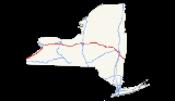
Interstate 90 in New York
Encyclopedia
Interstate 90 is a part of the Interstate Highway System
that runs from Seattle, Washington
, to Boston, Massachusetts. In the U.S. state
of New York
, I-90 extends 385.88 miles (621.01 km) from the Pennsylvania state line at Ripley
to the Massachusetts
state line at Canaan
. Although most of the route is part of the New York State Thruway
, a non-tolled section (situated in the Capital District
and not part of the Thruway system) links Albany
and its eastern suburbs. Within New York, I-90 has a complete set of auxiliary Interstates. For most of its length in New York, I-90 runs parallel to the former Erie Canal
route, New York State Route 5 (NY 5), U.S. Route 20
(US 20) and the CSX railroad mainline that traverses the state.
I-90 was assigned in 1957 as part of the establishment of the Interstate Highway System. In New York, it was overlaid on the pre-existing New York State Thruway from Pennsylvania to Albany, from where it would have continued to Massachusetts on a new freeway that bypassed the Berkshire Connector to the north. Ultimately, the freeway was built from the Thruway mainline in Albany to the Berkshire Connector in Schodack
, and I-90 was assigned to the segment of the Connector east of the proposed freeway. The Albany–Schodack freeway was completed in stages during the 1960s and 1970s and fully open by 1977.
, I-90 in New York is designated along the mainline of the New York State Thruway
. The Thruway begins at the Pennsylvania
state line in Chautauqua County
, following the shore of Lake Erie
northeast and passes through the town of Cheektowaga, a large suburb
of Buffalo
directly east of the city. Two auxiliary routes, I-190
(leading to Niagara Falls
) and I-290
(a northerly bypass of Buffalo) connect with I-90 here. East of Erie County
, the Thruway turns east and passes through the suburbs of several major cities in Upstate New York
, generally following the path of the Erie Canal
. It passes south of Rochester
and north of Syracuse
, which are served by three auxiliary Interstate Highways: I-490
and I-390
connect to Rochester, while I-690
leads to Syracuse.
East of Syracuse, the Thruway follows the Erie Canal and, later, the Mohawk River
into the Mohawk Valley
toward Utica
, where I-90 skirts the northern edge of downtown and meets I-790
, a short route leading into the city's center. Farther east, the freeway indirectly serves the canal and riverside cities of Little Falls
(via NY 169
) and Amsterdam
(NY 30
) on its way to Schenectady
, where I-890
splits from the Thruway and serves as the connection to the city center. It rejoins I-90 in Albany County
, where I-90 leaves the mainline of the Thruway at exit 24 in Albany
, which is signed for I-87 north and I-90 east. Here, the route designation of the Thruway changes from I-90 east to I-87 south. Traffic intending to continue on I-90 or reach I-87 north must exit the Thruway here. Exit numbers and mile markers for I-90 reset after exiting.
section of I-90—the only portion of I-90 in New York that is not part of the Thruway system—begins concurrent with I-87 and heads southeast from Thruway exit 24 to a toll barrier that, for now, marks the end of tolls along the freeway. Now a toll-free highway, I-90 and I-87 continue to exits 1N and 1S, which are for the Adirondack Northway (I-87) and Fuller Road Alternate (unsigned NY 910F), respectively. Located off exit 1S and Fuller Road Alternate, a spur of the Northway leading to Western Avenue (US 20
), is the Crossgates Mall
in Guilderland
. I-90 proceeds eastward, meeting Washington Avenue at an interchange connecting to UAlbany, a state college, eastbound and Fuller Road (County Route 156 or CR 156) westbound.
Exits 3 and 4, located 0.6 mile (0.965604 km) apart in an area bounded by Washington and Central (NY 5
) Avenues, lead to the W. Averell Harriman State Office Building Campus
and the New York State Police Academy (exit 3) and to the Crosstown Arterial (NY 85
at exit 4). I-90 subsequently crosses over NY 5 and passes north of Westgate Plaza
as it connects to Everett Road (CR 155). The freeway continues along the northern edge of Albany to exit 5A, a large trumpet interchange originally built to serve I-687
. After that project was cancelled, it was repurposed as an exit for Corporate Woods Boulevard. East of exit 5A, I-90 passes by slightly more residential areas ahead of a stack interchange
with US 9 1 miles (1.6 km) north of downtown Albany. Albany Memorial Hospital is located just north of the exit on US 9.
Not far to the east of US 9 is a second stack interchange, connecting I-90 to I-787
in the industrial northeasternmost section of the city of Albany. At this point, I-90 turns to the southeast and follows the Patroon Island Bridge
over the Hudson River
and into Rensselaer County
. Across the river, I-90 becomes the Rensselaer County Veterans Memorial Highway and passes through much less developed areas. In its first 1.5 miles (2.4 km) in the county, the freeway meets Washington Avenue at the northern edge of the city of Rensselaer
and the west end of NY 43
in the town of North Greenbush
, southwest of US 4
and Defreestville. South of NY 43, I-90 and US 4 follow parallel routings into East Greenbush, where I-90 directly connects to US 4 at exit 11.
I-90 heads southeastward across an undeveloped, forested section of the county, crossing over NY 151
and entering the town of Schodack, where it meets Miller Road, a connector between I-90 and the concurrent routes of US 9 and US 20
. The freeway and the overlapping U.S. Routes follow similar routings to Schodack Center
, at which point I-90 finally connects to US 9 and US 20 at exits 11E and 11W. I-90 heads due south from this point, passing over NY 150
and paralleling US 9, which splits from US 20 at Schodack Center. The routes cross paths again at exit 12 just north of where I-90 rejoins the Thruway system at a toll barrier preceding exit B1 of the Berkshire Connector.
in the Columbia County
town of Chatham
at exit B2 and NY 22
at exit B3 in the town of Canaan
1 miles (1.6 km) from the Massachusetts
state line. The Berkshire Connector ends at the state line; however, I-90 continues southeast into Massachusetts as the Massachusetts Turnpike
.
(1825), New York Central Railroad
(1853), and later the Yellowstone Trail
(1912), which became US 20
and NY 5
. It was planned as part of a nationwide toll road
system as early as 1938. Exactly which cities would be served changed over the years, but it was the state of New York that made the decision in 1942, when they passed a law for the construction of a New York City
– Albany
– Buffalo
– Pennsylvania
"thruway". This highway, passing Utica
, Syracuse
, and Rochester
on its path between Albany and Buffalo, would provide construction jobs in the post-World War II period. The Berkshire Thruway, a branch east from near Albany to Massachusetts
, was authorized in 1944, completing the east–west route across the state. However, construction, which began in 1946, proceeded very slowly, with only one four-mile (6 km) portion open by 1950, when a law created the New York State Thruway Authority (NYSTA) to operate the route as a toll road
. Construction then progressed much more rapidly, especially after 1954, when the authority was allowed to issue bond
s not backed by the state (thus having higher interest rate
s). The roadway was completed between Buffalo and Albany in 1954, to New York City in 1956, to Pennsylvania in 1957, and to Massachusetts in 1959.
In the meantime, the National Interstate and Defense Highways Act was enacted in 1956, promising a toll-free network of Interstate Highways throughout the nation. The Bureau of Public Roads (BPR) commissioner soon announced that the toll road met all federal Interstate Highway standards
, and on August 14, 1957, most of the mainline of the Thruway was incorporated into the system as part of Interstates 87
and 90. Most of the connecting Massachusetts Turnpike
was also included, but a more northerly alignment, avoiding the Berkshire Thruway, was proposed by the states of New York and Massachusetts for I-90 through Albany past Pittsfield to East Lee, Massachusetts. This alignment would be about 30% shorter than the all-toll alignment, and would provide relief to the four-lane Castleton Bridge
on the Berkshire Thruway, which had been built narrower than the rest of the system because of the planned parallel alternate. The BPR objected to the duplication, which would cost over $90 million, and refused to approve this alignment. The eventual route ran southeast from Albany to the Berkshire Thruway at the Nassau interchange, providing Albany with an alternate route and additional bridge, but not offering any savings in distance, and creating a "toll trap" for drivers accessing the Taconic State Parkway
from Albany.
Construction on the route of I-90 through Albany began ca. 1963, with both ends at existing Thruway interchanges: exit 24, which crossed the Adirondack Northway (I-87) at a cloverleaf interchange
and connected to Washington Avenue in western Albany, and exit B1, which connected to US 9 near Nassau. Work on the freeway began at the Northway and progressed southeasterly to the Berkshire Connector in Rensselaer County. The portion between the Northway and Everett Road was opened to traffic in the mid-1960s while the piece extending from Everett Road to US 4
east of Rensselaer
was completed in the early 1970s. The last section of the highway was completed to US 9 and US 20 in Schodack Center
ca. 1974 and finished by 1977. The Northway cloverleaf was rebuilt in the late 1980s.
In 1999, the New York State Department of Transportation
, the Federal Highway Administration
and NYSTA discussed redesignating the Berkshire Connector as I-90 and redesignating the non-toll part of I-90 from Thruway exit 24 to exit B1 on the Connector as I-88
. The section of the Thruway between exits 25 and 24 would then be co-designated
as both I-90 and I-88. This was never implemented.
|rowspan=10|Albany
|rowspan=10|Albany
|0.00
|25-61-23-1
|
|East end of Thruway (mainline) overlap; west end of I-87 overlap
|-
|0.25
|1S
|
|
|-
|0.40
|1N
|
|East end of I-87 overlap
|-
|1.10
|2
|Washington Avenue / Fuller Road – UAlbany
|
|-
|2.04
|3
|State Offices
|
|-
|2.36
|4
|
|Eastern terminus of NY 85
|-
|3.38
|5
|Everett Road
|
|-
|4.00
|5A
|Corporate Woods Boulevard
|Formerly planned for I-687
|-
|5.51
|6
|
|
|-
|6.36
|6A
|
|
|-
|rowspan=7|Rensselaer
|Rensselaer
|7.15
|7
|Washington Avenue – Rensselaer
|Eastbound exit and westbound entrance
|-
|North Greenbush
|7.95
|8
|
|Western terminus of NY 43
|-
|East Greenbush
|9.68
|9
|
|
|-
|rowspan=4|Schodack
|13.32
|10
|Miller Road – Schodack Center
, East Greenbush
|
|-
|14.74
|11
|
|Signed as exits 11W (north/west) and 11E (south/east) eastbound
|-
|19.80
|12
|
|
|-
|20.18
|
|
|West end of Thruway (Berkshire Connector) overlap
Interstate Highway System
The Dwight D. Eisenhower National System of Interstate and Defense Highways, , is a network of limited-access roads including freeways, highways, and expressways forming part of the National Highway System of the United States of America...
that runs from Seattle, Washington
Seattle, Washington
Seattle is the county seat of King County, Washington. With 608,660 residents as of the 2010 Census, Seattle is the largest city in the Northwestern United States. The Seattle metropolitan area of about 3.4 million inhabitants is the 15th largest metropolitan area in the country...
, to Boston, Massachusetts. In the U.S. state
U.S. state
A U.S. state is any one of the 50 federated states of the United States of America that share sovereignty with the federal government. Because of this shared sovereignty, an American is a citizen both of the federal entity and of his or her state of domicile. Four states use the official title of...
of New York
New York
New York is a state in the Northeastern region of the United States. It is the nation's third most populous state. New York is bordered by New Jersey and Pennsylvania to the south, and by Connecticut, Massachusetts and Vermont to the east...
, I-90 extends 385.88 miles (621.01 km) from the Pennsylvania state line at Ripley
Ripley, New York
Ripley is a town on Lake Erie in the westernmost part of Chautauqua County, New York, USA. The population was 2,636 at the 2000 census. The town was named after General Eleazer Wheelock Ripley. There are no incorporated villages in the town, but there is one CDP: Ripley.- History :Ripley was...
to the Massachusetts
Massachusetts
The Commonwealth of Massachusetts is a state in the New England region of the northeastern United States of America. It is bordered by Rhode Island and Connecticut to the south, New York to the west, and Vermont and New Hampshire to the north; at its east lies the Atlantic Ocean. As of the 2010...
state line at Canaan
Canaan, New York
Canaan is a town in Columbia County, New York, United States. The population was 1,820 at the 2000 census.The Town of Canaan is in the northeast part of the county.- History :The first settlers arrived around 1759....
. Although most of the route is part of the New York State Thruway
New York State Thruway
The New York State Thruway is a system of limited-access highways located within the state of New York in the United States. The system, known officially as the Governor Thomas E. Dewey Thruway for former New York Governor Thomas E. Dewey, is operated by the New York State Thruway Authority and...
, a non-tolled section (situated in the Capital District
Capital District
New York's Capital District, also known as the Capital Region, is a region in upstate New York that generally refers to the four counties surrounding Albany, the capital of the state: Albany County, Schenectady County, Rensselaer County, and Saratoga County...
and not part of the Thruway system) links Albany
Albany, New York
Albany is the capital city of the U.S. state of New York, the seat of Albany County, and the central city of New York's Capital District. Roughly north of New York City, Albany sits on the west bank of the Hudson River, about south of its confluence with the Mohawk River...
and its eastern suburbs. Within New York, I-90 has a complete set of auxiliary Interstates. For most of its length in New York, I-90 runs parallel to the former Erie Canal
Erie Canal
The Erie Canal is a waterway in New York that runs about from Albany, New York, on the Hudson River to Buffalo, New York, at Lake Erie, completing a navigable water route from the Atlantic Ocean to the Great Lakes. The canal contains 36 locks and encompasses a total elevation differential of...
route, New York State Route 5 (NY 5), U.S. Route 20
U.S. Route 20 in New York
U.S. Route 20 is a part of the U.S. Highway System that runs from Newport, Oregon, to Boston, Massachusetts. In the U.S. state of New York, US 20 extends from the Pennsylvania state line at Ripley to the Massachusetts state line in the Berkshire Mountains. US 20 is the longest...
(US 20) and the CSX railroad mainline that traverses the state.
I-90 was assigned in 1957 as part of the establishment of the Interstate Highway System. In New York, it was overlaid on the pre-existing New York State Thruway from Pennsylvania to Albany, from where it would have continued to Massachusetts on a new freeway that bypassed the Berkshire Connector to the north. Ultimately, the freeway was built from the Thruway mainline in Albany to the Berkshire Connector in Schodack
Schodack, New York
Schodack is a town in Rensselaer County, New York, United States. The population was 12,536 at the 2000 census. The town name is derived from the native word, Escotak. The town is in the southwestern part of the county. Schodack is southeast of Albany, New York.- History :Prior to the advent of...
, and I-90 was assigned to the segment of the Connector east of the proposed freeway. The Albany–Schodack freeway was completed in stages during the 1960s and 1970s and fully open by 1977.
New York State Thruway
West of AlbanyAlbany, New York
Albany is the capital city of the U.S. state of New York, the seat of Albany County, and the central city of New York's Capital District. Roughly north of New York City, Albany sits on the west bank of the Hudson River, about south of its confluence with the Mohawk River...
, I-90 in New York is designated along the mainline of the New York State Thruway
New York State Thruway
The New York State Thruway is a system of limited-access highways located within the state of New York in the United States. The system, known officially as the Governor Thomas E. Dewey Thruway for former New York Governor Thomas E. Dewey, is operated by the New York State Thruway Authority and...
. The Thruway begins at the Pennsylvania
Pennsylvania
The Commonwealth of Pennsylvania is a U.S. state that is located in the Northeastern and Mid-Atlantic regions of the United States. The state borders Delaware and Maryland to the south, West Virginia to the southwest, Ohio to the west, New York and Ontario, Canada, to the north, and New Jersey to...
state line in Chautauqua County
Chautauqua County, New York
-Major highways:* Interstate 86/New York State Route 17 * Interstate 90 * U.S. Route 20* U.S. Route 62* New York State Route 5* New York State Route 39* New York State Route 60* New York State Route 394...
, following the shore of Lake Erie
Lake Erie
Lake Erie is the fourth largest lake of the five Great Lakes in North America, and the tenth largest globally. It is the southernmost, shallowest, and smallest by volume of the Great Lakes and therefore also has the shortest average water residence time. It is bounded on the north by the...
northeast and passes through the town of Cheektowaga, a large suburb
Suburb
The word suburb mostly refers to a residential area, either existing as part of a city or as a separate residential community within commuting distance of a city . Some suburbs have a degree of administrative autonomy, and most have lower population density than inner city neighborhoods...
of Buffalo
Buffalo, New York
Buffalo is the second most populous city in the state of New York, after New York City. Located in Western New York on the eastern shores of Lake Erie and at the head of the Niagara River across from Fort Erie, Ontario, Buffalo is the seat of Erie County and the principal city of the...
directly east of the city. Two auxiliary routes, I-190
Interstate 190 (New York)
Interstate 190 runs 28.34 miles from Interstate 90 near Buffalo, New York to Lewiston, New York via Niagara Falls. Parts of this highway were built on the former rights-of-way of the Lehigh Valley Railroad and the Erie Canal. It is referred to by locals as The One-Ninety...
(leading to Niagara Falls
Niagara Falls, New York
Niagara Falls is a city in Niagara County, New York, United States. As of the 2010 census, the city had a total population of 50,193, down from the 55,593 recorded in the 2000 census. It is across the Niagara River from Niagara Falls, Ontario , both named after the famed Niagara Falls which they...
) and I-290
Interstate 290 (New York)
Interstate 290 runs for near Buffalo, New York from I-90 to I-190. It connects Buffalo with its northern suburbs of Amherst and Tonawanda, and provides a route to Niagara Falls that bypasses the city of Buffalo. I-290 also connects to Interstate 990, and through this connection,...
(a northerly bypass of Buffalo) connect with I-90 here. East of Erie County
Erie County, New York
Erie County is a county located in the U.S. state of New York. As of the 2010 census, the population was 919,040. The county seat is Buffalo. The county's name comes from Lake Erie, which in turn comes from the Erie tribe of American Indians who lived south and east of the lake before 1654.Erie...
, the Thruway turns east and passes through the suburbs of several major cities in Upstate New York
Upstate New York
Upstate New York is the region of the U.S. state of New York that is located north of the core of the New York metropolitan area.-Definition:There is no clear or official boundary between Upstate New York and Downstate New York...
, generally following the path of the Erie Canal
Erie Canal
The Erie Canal is a waterway in New York that runs about from Albany, New York, on the Hudson River to Buffalo, New York, at Lake Erie, completing a navigable water route from the Atlantic Ocean to the Great Lakes. The canal contains 36 locks and encompasses a total elevation differential of...
. It passes south of Rochester
Rochester, New York
Rochester is a city in Monroe County, New York, south of Lake Ontario in the United States. Known as The World's Image Centre, it was also once known as The Flour City, and more recently as The Flower City...
and north of Syracuse
Syracuse, New York
Syracuse is a city in and the county seat of Onondaga County, New York, United States, the largest U.S. city with the name "Syracuse", and the fifth most populous city in the state. At the 2010 census, the city population was 145,170, and its metropolitan area had a population of 742,603...
, which are served by three auxiliary Interstate Highways: I-490
Interstate 490 (New York)
Interstate 490 is an auxiliary Interstate Highway that serves the city of Rochester, New York, in the United States. It acts as a northerly alternate route to the New York State Thruway , leaving it at exit 47 in the town of Le Roy and rejoining the highway at exit 45 in the town of...
and I-390
Interstate 390
Interstate 390 is a north–south auxiliary Interstate Highway located entirely within New York in the United States. The southern terminus of the route is at the Southern Tier Expressway in the town of Avoca. Its northern terminus is at I-490 in Rochester...
connect to Rochester, while I-690
Interstate 690
Interstate 690 is an auxiliary Interstate Highway that extends for through the vicinity of Syracuse, New York, in the United States. It is a spur of I-90 that travels southeast from Thruway exit 39 in Van Buren to I-481 in DeWitt...
leads to Syracuse.
East of Syracuse, the Thruway follows the Erie Canal and, later, the Mohawk River
Mohawk River
The Mohawk River is a river in the U.S. state of New York. It is the largest tributary of the Hudson River. The Mohawk flows into the Hudson in the Capital District, a few miles north of the city of Albany. The river is named for the Mohawk Nation of the Iroquois Confederacy...
into the Mohawk Valley
Mohawk Valley
The Mohawk Valley region of the U.S. state of New York is the area surrounding the Mohawk River, sandwiched between the Adirondack Mountains and Catskill Mountains....
toward Utica
Utica, New York
Utica is a city in and the county seat of Oneida County, New York, United States. The population was 62,235 at the 2010 census, an increase of 2.6% from the 2000 census....
, where I-90 skirts the northern edge of downtown and meets I-790
Interstate 790
Interstate 790 is an auxiliary Interstate Highway in the city of Utica, New York, in the United States. It runs for from an interchange with NY 5A and NY 5S in downtown Utica to exit 31 of the New York State Thruway east of the city...
, a short route leading into the city's center. Farther east, the freeway indirectly serves the canal and riverside cities of Little Falls
Little Falls (city), New York
Little Falls is a city in Herkimer County, New York, USA. The population was 5,188 at the 2000 census. The name is derived from a small cataract near the city....
(via NY 169
New York State Route 169
New York State Route 169 is a north–south state highway located within Herkimer County, New York, in the United States. It extends for from an intersection with NY 5S in the town of Danube to a junction with NY 28 and NY 29 in the village of Middleville...
) and Amsterdam
Amsterdam (city), New York
Amsterdam is a city located in Montgomery County, New York, USA. As of the 2010 census, the city had a total population of 18,620. The name is derived from the city of Amsterdam in the Netherlands....
(NY 30
New York State Route 30
New York State Route 30 is a state highway in the central part of New York in the United States. It extends for from an interchange with NY 17 in the Southern Tier to the Canadian border in the state's North Country, where it continues into Quebec as Route 138. On a regional level,...
) on its way to Schenectady
Schenectady, New York
Schenectady is a city in Schenectady County, New York, United States, of which it is the county seat. As of the 2010 census, the city had a population of 66,135...
, where I-890
Interstate 890
Interstate 890 is a long auxiliary Interstate Highway in the vicinity of Schenectady, New York, United States. The highway runs southeast–northwest from an interchange with the New York State Thruway northwest of Schenectady to another junction with the Thruway south of the city and passes...
splits from the Thruway and serves as the connection to the city center. It rejoins I-90 in Albany County
Albany County, New York
Albany County is a county located in the U.S. state of New York, and is part of the Albany-Schenectady-Troy Metropolitan Statistical Area. The name is from the title of the Duke of York and Albany, who became James II of England . As of the 2010 census, the population was 304,204...
, where I-90 leaves the mainline of the Thruway at exit 24 in Albany
Albany, New York
Albany is the capital city of the U.S. state of New York, the seat of Albany County, and the central city of New York's Capital District. Roughly north of New York City, Albany sits on the west bank of the Hudson River, about south of its confluence with the Mohawk River...
, which is signed for I-87 north and I-90 east. Here, the route designation of the Thruway changes from I-90 east to I-87 south. Traffic intending to continue on I-90 or reach I-87 north must exit the Thruway here. Exit numbers and mile markers for I-90 reset after exiting.
Albany and Rensselaer counties
The Albany–SchodackSchodack, New York
Schodack is a town in Rensselaer County, New York, United States. The population was 12,536 at the 2000 census. The town name is derived from the native word, Escotak. The town is in the southwestern part of the county. Schodack is southeast of Albany, New York.- History :Prior to the advent of...
section of I-90—the only portion of I-90 in New York that is not part of the Thruway system—begins concurrent with I-87 and heads southeast from Thruway exit 24 to a toll barrier that, for now, marks the end of tolls along the freeway. Now a toll-free highway, I-90 and I-87 continue to exits 1N and 1S, which are for the Adirondack Northway (I-87) and Fuller Road Alternate (unsigned NY 910F), respectively. Located off exit 1S and Fuller Road Alternate, a spur of the Northway leading to Western Avenue (US 20
U.S. Route 20 in New York
U.S. Route 20 is a part of the U.S. Highway System that runs from Newport, Oregon, to Boston, Massachusetts. In the U.S. state of New York, US 20 extends from the Pennsylvania state line at Ripley to the Massachusetts state line in the Berkshire Mountains. US 20 is the longest...
), is the Crossgates Mall
Crossgates Mall
Crossgates Mall is a shopping mall located in Albany, New York, United States, not far from Schenectady. The mall opened on March 4, 1984, and in October 1994 underwent a large expansion that nearly doubled its size. It now has a gross leasable area of with two floors including 250 shops and...
in Guilderland
Guilderland, New York
Guilderland is a town in Albany County, New York, United States. In the 2010 census, the town had a population of 35,303. The town is named for the Gelderland province in the Netherlands....
. I-90 proceeds eastward, meeting Washington Avenue at an interchange connecting to UAlbany, a state college, eastbound and Fuller Road (County Route 156 or CR 156) westbound.
Exits 3 and 4, located 0.6 mile (0.965604 km) apart in an area bounded by Washington and Central (NY 5
New York State Route 5
New York State Route 5 is a state highway that extends for across the state of New York in the United States. It begins at the Pennsylvania state line in the Chautauqua County town of Ripley and passes through Buffalo, Syracuse, Utica, Schenectady, and several other smaller cities and...
) Avenues, lead to the W. Averell Harriman State Office Building Campus
W. Averell Harriman State Office Building Campus
The W. Averell Harriman State Office Building Campus is an office park in western Albany, New York, United States that houses sixteen New York State Government office buildings. The land totals roughly and over 3 million square feet of office space, and about 7,000 state employees work there...
and the New York State Police Academy (exit 3) and to the Crosstown Arterial (NY 85
New York State Route 85
New York State Route 85 is a state highway in Albany County, New York, in the United States. It is long and runs from County Route 351 and CR 353 in Rensselaerville to Interstate 90 exit 4 in Albany. It also has a loop route, NY 85A, which connects NY 85 to...
at exit 4). I-90 subsequently crosses over NY 5 and passes north of Westgate Plaza
Westgate Plaza (Albany, New York)
Westgate Plaza is a large strip mall in the city of Albany, New York, located on Central Avenue. Westgate is considered the first mall in the Albany area, and opened in 1957.-Tenants:Over the years, tenants have included:-Redevelopment:...
as it connects to Everett Road (CR 155). The freeway continues along the northern edge of Albany to exit 5A, a large trumpet interchange originally built to serve I-687
Interstate 687
Interstate 687 was a proposed auxiliary Interstate Highway in the Capital District region of New York in the United States. The highway would have connected I-90 in Albany to I-87 near Albany International Airport in Colonie...
. After that project was cancelled, it was repurposed as an exit for Corporate Woods Boulevard. East of exit 5A, I-90 passes by slightly more residential areas ahead of a stack interchange
Stack interchange
A stack interchange is a free-flowing grade separated junction between two roads.In countries where one drives on the right, left turns are handled by semi-directional flyover/under ramps...
with US 9 1 miles (1.6 km) north of downtown Albany. Albany Memorial Hospital is located just north of the exit on US 9.
Not far to the east of US 9 is a second stack interchange, connecting I-90 to I-787
Interstate 787
Interstate 787 is an auxiliary Interstate Highway in the U.S. state of New York. I-787 is the main highway for those traveling into and out of downtown Albany. The southern terminus is at the Interstate 87/New York State Thruway exit 23 toll plaza southwest of downtown Albany...
in the industrial northeasternmost section of the city of Albany. At this point, I-90 turns to the southeast and follows the Patroon Island Bridge
Patroon Island Bridge
The Patroon Island Bridge is a major crossing of the Hudson River in Albany, New York. The bridge carries Interstate 90, in the east-west direction, over the Hudson River between Albany and Rensselaer Counties....
over the Hudson River
Hudson River
The Hudson is a river that flows from north to south through eastern New York. The highest official source is at Lake Tear of the Clouds, on the slopes of Mount Marcy in the Adirondack Mountains. The river itself officially begins in Henderson Lake in Newcomb, New York...
and into Rensselaer County
Rensselaer County, New York
Rensselaer County is a county in the U.S. state of New York. As of the 2010 census, the population was 159,429. Its name is in honor of the family of Kiliaen van Rensselaer, the original Dutch owner of the land in the area. Its county seat is Troy...
. Across the river, I-90 becomes the Rensselaer County Veterans Memorial Highway and passes through much less developed areas. In its first 1.5 miles (2.4 km) in the county, the freeway meets Washington Avenue at the northern edge of the city of Rensselaer
Rensselaer, New York
Rensselaer is a city in Rensselaer County, New York, United States, and is located on the Hudson River directly opposite Albany. As of the 2010 census, the city population was 9,392; in 1920, it was 10,832. The name is from Kiliaen van Rensselaer, the original landowner of the region in New...
and the west end of NY 43
New York State Route 43
New York State Route 43 is a state highway in Rensselaer County, New York, United States. It extends for from Interstate 90 exit 8 in North Greenbush to the Massachusetts state line, where it continues into Williamstown as Massachusetts Route 43...
in the town of North Greenbush
North Greenbush, New York
North Greenbush is a town in Rensselaer County, New York, United States. North Greenbush is located in the western part of the county. The population was 10,805 at the 2000 census....
, southwest of US 4
U.S. Route 4 in New York
U.S. Route 4 is a part of the U.S. Highway System that runs from East Greenbush, New York, to Portsmouth, New Hampshire. In the U.S. state of New York, US 4 extends from an intersection with US 9 and US 20 in East Greenbush to the Vermont state line northeast of Whitehall...
and Defreestville. South of NY 43, I-90 and US 4 follow parallel routings into East Greenbush, where I-90 directly connects to US 4 at exit 11.
I-90 heads southeastward across an undeveloped, forested section of the county, crossing over NY 151
New York State Route 151
New York State Route 151 is an state highway located in Rensselaer County, New York, in the United States. Its western terminus is at an interchange with U.S. Route 9 and US 20 in Rensselaer, and its eastern terminus is at a junction with NY 150 in Shivers Corners, a hamlet...
and entering the town of Schodack, where it meets Miller Road, a connector between I-90 and the concurrent routes of US 9 and US 20
U.S. Route 20 in New York
U.S. Route 20 is a part of the U.S. Highway System that runs from Newport, Oregon, to Boston, Massachusetts. In the U.S. state of New York, US 20 extends from the Pennsylvania state line at Ripley to the Massachusetts state line in the Berkshire Mountains. US 20 is the longest...
. The freeway and the overlapping U.S. Routes follow similar routings to Schodack Center
Schodack Center, New York
Schodack Center is a hamlet in the town of Schodack, Rensselaer County, New York, United States. Schodack Center is located at the junction of Interstate 90, U.S. Route 20, and U.S. Route 9....
, at which point I-90 finally connects to US 9 and US 20 at exits 11E and 11W. I-90 heads due south from this point, passing over NY 150
New York State Route 150
New York State Route 150 is a north–south state highway in Rensselaer County, New York, United States. The southern terminus of the route is at NY 9J in Castleton-on-Hudson...
and paralleling US 9, which splits from US 20 at Schodack Center. The routes cross paths again at exit 12 just north of where I-90 rejoins the Thruway system at a toll barrier preceding exit B1 of the Berkshire Connector.
Berkshire Connector
I-90 heads southeast on the Connector, meeting the north end of the Taconic State ParkwayTaconic State Parkway
The Taconic State Parkway , is a divided highway between Kensico Dam and Chatham, the longest parkway in the U.S. state of New York. It follows a generally northward route midway between the Hudson River and the Connecticut and Massachusetts state lines...
in the Columbia County
Columbia County, New York
Columbia County is a county located in the U.S. state of New York. As of the 2010 census, the population was 63,096. The county seat is Hudson. The name comes from the Latin feminine form of the name of Christopher Columbus, which was at the time of the formation of the county a popular proposal...
town of Chatham
Chatham (town), New York
Chatham is a town in Columbia County, United States. New York, United States. The population was 4,249 at the 2000 census.The Town of Chatham has a village also called Chatham on its south town line...
at exit B2 and NY 22
New York State Route 22
New York State Route 22 is a north–south state highway in eastern New York in the United States. It runs parallel to the state's eastern edge from the outskirts of New York City to a short distance south of the Canadian border. At , it is the state's longest north–south route and...
at exit B3 in the town of Canaan
Canaan, New York
Canaan is a town in Columbia County, New York, United States. The population was 1,820 at the 2000 census.The Town of Canaan is in the northeast part of the county.- History :The first settlers arrived around 1759....
1 miles (1.6 km) from the Massachusetts
Massachusetts
The Commonwealth of Massachusetts is a state in the New England region of the northeastern United States of America. It is bordered by Rhode Island and Connecticut to the south, New York to the west, and Vermont and New Hampshire to the north; at its east lies the Atlantic Ocean. As of the 2010...
state line. The Berkshire Connector ends at the state line; however, I-90 continues southeast into Massachusetts as the Massachusetts Turnpike
Massachusetts Turnpike
The Massachusetts Turnpike is the easternmost stretch of Interstate 90. The Turnpike begins at the western border of Massachusetts in West Stockbridge connecting with the Berkshire Connector portion of the New York State Thruway...
.
History
The east–west corridor I-90 follows across New York has always been major, followed by the Genesee Trail (1790s), Erie CanalErie Canal
The Erie Canal is a waterway in New York that runs about from Albany, New York, on the Hudson River to Buffalo, New York, at Lake Erie, completing a navigable water route from the Atlantic Ocean to the Great Lakes. The canal contains 36 locks and encompasses a total elevation differential of...
(1825), New York Central Railroad
New York Central Railroad
The New York Central Railroad , known simply as the New York Central in its publicity, was a railroad operating in the Northeastern United States...
(1853), and later the Yellowstone Trail
Yellowstone Trail
The Yellowstone Trail was the first transcontinental automobile highway through the upper tier of states in the United States. It ran from Massachusetts to Seattle. It was conceived by J.W. Parmley of Ipswich, South Dakota in 1912. Originally, Parmley and his business colleagues wanted a good road...
(1912), which became US 20
U.S. Route 20 in New York
U.S. Route 20 is a part of the U.S. Highway System that runs from Newport, Oregon, to Boston, Massachusetts. In the U.S. state of New York, US 20 extends from the Pennsylvania state line at Ripley to the Massachusetts state line in the Berkshire Mountains. US 20 is the longest...
and NY 5
New York State Route 5
New York State Route 5 is a state highway that extends for across the state of New York in the United States. It begins at the Pennsylvania state line in the Chautauqua County town of Ripley and passes through Buffalo, Syracuse, Utica, Schenectady, and several other smaller cities and...
. It was planned as part of a nationwide toll road
Toll road
A toll road is a privately or publicly built road for which a driver pays a toll for use. Structures for which tolls are charged include toll bridges and toll tunnels. Non-toll roads are financed using other sources of revenue, most typically fuel tax or general tax funds...
system as early as 1938. Exactly which cities would be served changed over the years, but it was the state of New York that made the decision in 1942, when they passed a law for the construction of a New York City
New York City
New York is the most populous city in the United States and the center of the New York Metropolitan Area, one of the most populous metropolitan areas in the world. New York exerts a significant impact upon global commerce, finance, media, art, fashion, research, technology, education, and...
– Albany
Albany, New York
Albany is the capital city of the U.S. state of New York, the seat of Albany County, and the central city of New York's Capital District. Roughly north of New York City, Albany sits on the west bank of the Hudson River, about south of its confluence with the Mohawk River...
– Buffalo
Buffalo, New York
Buffalo is the second most populous city in the state of New York, after New York City. Located in Western New York on the eastern shores of Lake Erie and at the head of the Niagara River across from Fort Erie, Ontario, Buffalo is the seat of Erie County and the principal city of the...
– Pennsylvania
Pennsylvania
The Commonwealth of Pennsylvania is a U.S. state that is located in the Northeastern and Mid-Atlantic regions of the United States. The state borders Delaware and Maryland to the south, West Virginia to the southwest, Ohio to the west, New York and Ontario, Canada, to the north, and New Jersey to...
"thruway". This highway, passing Utica
Utica, New York
Utica is a city in and the county seat of Oneida County, New York, United States. The population was 62,235 at the 2010 census, an increase of 2.6% from the 2000 census....
, Syracuse
Syracuse, New York
Syracuse is a city in and the county seat of Onondaga County, New York, United States, the largest U.S. city with the name "Syracuse", and the fifth most populous city in the state. At the 2010 census, the city population was 145,170, and its metropolitan area had a population of 742,603...
, and Rochester
Rochester, New York
Rochester is a city in Monroe County, New York, south of Lake Ontario in the United States. Known as The World's Image Centre, it was also once known as The Flour City, and more recently as The Flower City...
on its path between Albany and Buffalo, would provide construction jobs in the post-World War II period. The Berkshire Thruway, a branch east from near Albany to Massachusetts
Massachusetts
The Commonwealth of Massachusetts is a state in the New England region of the northeastern United States of America. It is bordered by Rhode Island and Connecticut to the south, New York to the west, and Vermont and New Hampshire to the north; at its east lies the Atlantic Ocean. As of the 2010...
, was authorized in 1944, completing the east–west route across the state. However, construction, which began in 1946, proceeded very slowly, with only one four-mile (6 km) portion open by 1950, when a law created the New York State Thruway Authority (NYSTA) to operate the route as a toll road
Toll road
A toll road is a privately or publicly built road for which a driver pays a toll for use. Structures for which tolls are charged include toll bridges and toll tunnels. Non-toll roads are financed using other sources of revenue, most typically fuel tax or general tax funds...
. Construction then progressed much more rapidly, especially after 1954, when the authority was allowed to issue bond
Bond (finance)
In finance, a bond is a debt security, in which the authorized issuer owes the holders a debt and, depending on the terms of the bond, is obliged to pay interest to use and/or to repay the principal at a later date, termed maturity...
s not backed by the state (thus having higher interest rate
Interest rate
An interest rate is the rate at which interest is paid by a borrower for the use of money that they borrow from a lender. For example, a small company borrows capital from a bank to buy new assets for their business, and in return the lender receives interest at a predetermined interest rate for...
s). The roadway was completed between Buffalo and Albany in 1954, to New York City in 1956, to Pennsylvania in 1957, and to Massachusetts in 1959.
In the meantime, the National Interstate and Defense Highways Act was enacted in 1956, promising a toll-free network of Interstate Highways throughout the nation. The Bureau of Public Roads (BPR) commissioner soon announced that the toll road met all federal Interstate Highway standards
Interstate Highway standards
Standards for Interstate Highways in the United States are defined by the American Association of State Highway and Transportation Officials in the publication A Policy on Design Standards - Interstate System...
, and on August 14, 1957, most of the mainline of the Thruway was incorporated into the system as part of Interstates 87
Interstate 87
Interstate 87 is a Interstate Highway located entirely within New York State in the United States of America. I-87 is the longest intrastate Interstate highway in the Interstate Highway System. Its southern end is at the Bronx approaches of the Robert F. Kennedy Bridge in New York City...
and 90. Most of the connecting Massachusetts Turnpike
Massachusetts Turnpike
The Massachusetts Turnpike is the easternmost stretch of Interstate 90. The Turnpike begins at the western border of Massachusetts in West Stockbridge connecting with the Berkshire Connector portion of the New York State Thruway...
was also included, but a more northerly alignment, avoiding the Berkshire Thruway, was proposed by the states of New York and Massachusetts for I-90 through Albany past Pittsfield to East Lee, Massachusetts. This alignment would be about 30% shorter than the all-toll alignment, and would provide relief to the four-lane Castleton Bridge
Castleton Bridge
The Castleton Bridge is a cantilever truss bridge over the Hudson River that carries the Berkshire Connector of the New York State Thruway. This bridge is also sometimes called the Castleton-on-Hudson Bridge and is situated in close proximity to the Alfred H...
on the Berkshire Thruway, which had been built narrower than the rest of the system because of the planned parallel alternate. The BPR objected to the duplication, which would cost over $90 million, and refused to approve this alignment. The eventual route ran southeast from Albany to the Berkshire Thruway at the Nassau interchange, providing Albany with an alternate route and additional bridge, but not offering any savings in distance, and creating a "toll trap" for drivers accessing the Taconic State Parkway
Taconic State Parkway
The Taconic State Parkway , is a divided highway between Kensico Dam and Chatham, the longest parkway in the U.S. state of New York. It follows a generally northward route midway between the Hudson River and the Connecticut and Massachusetts state lines...
from Albany.
Construction on the route of I-90 through Albany began ca. 1963, with both ends at existing Thruway interchanges: exit 24, which crossed the Adirondack Northway (I-87) at a cloverleaf interchange
Cloverleaf interchange
A cloverleaf interchange is a two-level interchange in which left turns, reverse direction in left-driving regions, are handled by ramp roads...
and connected to Washington Avenue in western Albany, and exit B1, which connected to US 9 near Nassau. Work on the freeway began at the Northway and progressed southeasterly to the Berkshire Connector in Rensselaer County. The portion between the Northway and Everett Road was opened to traffic in the mid-1960s while the piece extending from Everett Road to US 4
U.S. Route 4 in New York
U.S. Route 4 is a part of the U.S. Highway System that runs from East Greenbush, New York, to Portsmouth, New Hampshire. In the U.S. state of New York, US 4 extends from an intersection with US 9 and US 20 in East Greenbush to the Vermont state line northeast of Whitehall...
east of Rensselaer
Rensselaer, New York
Rensselaer is a city in Rensselaer County, New York, United States, and is located on the Hudson River directly opposite Albany. As of the 2010 census, the city population was 9,392; in 1920, it was 10,832. The name is from Kiliaen van Rensselaer, the original landowner of the region in New...
was completed in the early 1970s. The last section of the highway was completed to US 9 and US 20 in Schodack Center
Schodack Center, New York
Schodack Center is a hamlet in the town of Schodack, Rensselaer County, New York, United States. Schodack Center is located at the junction of Interstate 90, U.S. Route 20, and U.S. Route 9....
ca. 1974 and finished by 1977. The Northway cloverleaf was rebuilt in the late 1980s.
In 1999, the New York State Department of Transportation
New York State Department of Transportation
The New York State Department of Transportation is responsible for the development and operation of highways, railroads, mass transit systems, ports, waterways and aviation facilities in the U.S...
, the Federal Highway Administration
Federal Highway Administration
The Federal Highway Administration is a division of the United States Department of Transportation that specializes in highway transportation. The agency's major activities are grouped into two "programs," the Federal-aid Highway Program and the Federal Lands Highway Program...
and NYSTA discussed redesignating the Berkshire Connector as I-90 and redesignating the non-toll part of I-90 from Thruway exit 24 to exit B1 on the Connector as I-88
Interstate 88 (east)
Interstate 88 is an intrastate Interstate Highway entirely within the U.S. state of New York. Its western end is at Interstate 81 in Binghamton and its eastern end is at Interstate 90 in Schenectady. It serves as an important connector route from Albany to Binghamton, Elmira , and...
. The section of the Thruway between exits 25 and 24 would then be co-designated
Concurrency (road)
A concurrency, overlap, or coincidence in a road network is an instance of one physical road bearing two or more different highway, motorway, or other route numbers...
as both I-90 and I-88. This was never implemented.
Exit list (non-Thruway part of I-90 in New York)
|-|rowspan=10|Albany
Albany County, New York
Albany County is a county located in the U.S. state of New York, and is part of the Albany-Schenectady-Troy Metropolitan Statistical Area. The name is from the title of the Duke of York and Albany, who became James II of England . As of the 2010 census, the population was 304,204...
|rowspan=10|Albany
Albany, New York
Albany is the capital city of the U.S. state of New York, the seat of Albany County, and the central city of New York's Capital District. Roughly north of New York City, Albany sits on the west bank of the Hudson River, about south of its confluence with the Mohawk River...
|0.00
|25-61-23-1
|
|East end of Thruway (mainline) overlap; west end of I-87 overlap
|-
|0.25
|1S
|
|
|-
|0.40
|1N
|
|East end of I-87 overlap
|-
|1.10
|2
|Washington Avenue / Fuller Road – UAlbany
|
|-
|2.04
|3
|State Offices
|
|-
|2.36
|4
|
|Eastern terminus of NY 85
|-
|3.38
|5
|Everett Road
|
|-
|4.00
|5A
|Corporate Woods Boulevard
|Formerly planned for I-687
|-
|5.51
|6
|
|
|-
|6.36
|6A
|
|
|-
|rowspan=7|Rensselaer
Rensselaer County, New York
Rensselaer County is a county in the U.S. state of New York. As of the 2010 census, the population was 159,429. Its name is in honor of the family of Kiliaen van Rensselaer, the original Dutch owner of the land in the area. Its county seat is Troy...
|Rensselaer
Rensselaer, New York
Rensselaer is a city in Rensselaer County, New York, United States, and is located on the Hudson River directly opposite Albany. As of the 2010 census, the city population was 9,392; in 1920, it was 10,832. The name is from Kiliaen van Rensselaer, the original landowner of the region in New...
|7.15
|7
|Washington Avenue – Rensselaer
Rensselaer, New York
Rensselaer is a city in Rensselaer County, New York, United States, and is located on the Hudson River directly opposite Albany. As of the 2010 census, the city population was 9,392; in 1920, it was 10,832. The name is from Kiliaen van Rensselaer, the original landowner of the region in New...
|Eastbound exit and westbound entrance
|-
|North Greenbush
North Greenbush, New York
North Greenbush is a town in Rensselaer County, New York, United States. North Greenbush is located in the western part of the county. The population was 10,805 at the 2000 census....
|7.95
|8
|
|Western terminus of NY 43
|-
|East Greenbush
|9.68
|9
|
|
|-
|rowspan=4|Schodack
Schodack, New York
Schodack is a town in Rensselaer County, New York, United States. The population was 12,536 at the 2000 census. The town name is derived from the native word, Escotak. The town is in the southwestern part of the county. Schodack is southeast of Albany, New York.- History :Prior to the advent of...
|13.32
|10
|Miller Road – Schodack Center
Schodack Center, New York
Schodack Center is a hamlet in the town of Schodack, Rensselaer County, New York, United States. Schodack Center is located at the junction of Interstate 90, U.S. Route 20, and U.S. Route 9....
, East Greenbush
|
|-
|14.74
|11
|
|Signed as exits 11W (north/west) and 11E (south/east) eastbound
|-
|19.80
|12
|
|
|-
|20.18
|
|
|West end of Thruway (Berkshire Connector) overlap