
Missoula, Montana
Overview
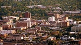
Missoula is a city located in western Montana
and is the county seat
of Missoula County
. The 2010 Census put the population of Missoula at 66,788 and the population of Missoula County at 109,299. Missoula is the principal city of the Missoula Metropolitan Area
. In 2000 Missoula became the second largest city in Montana, and since that time it has had the third largest actual growth amongst Montana's cities, with an increase in population of 9,735.
Missoula was founded in 1860 as Hellgate Trading Post before being renamed Missoula Mills ("Missoula" from the Salish
name for the area, "Nemissoolatakoo", and "Mills" after the prosperous flour mill and sawmill that served as Missoula's first industry).
Montana
Montana is a state in the Western United States. The western third of Montana contains numerous mountain ranges. Smaller, "island ranges" are found in the central third of the state, for a total of 77 named ranges of the Rocky Mountains. This geographical fact is reflected in the state's name,...
and is the county seat
County seat
A county seat is an administrative center, or seat of government, for a county or civil parish. The term is primarily used in the United States....
of Missoula County
Missoula County, Montana
-National protected areas:*Bitterroot National Forest *Flathead National Forest *Lolo National Forest *Rattlesnake National Recreation Area-Demographics:...
. The 2010 Census put the population of Missoula at 66,788 and the population of Missoula County at 109,299. Missoula is the principal city of the Missoula Metropolitan Area
Missoula Metropolitan area
The Missoula Metropolitan Statistical Area is located in the West-central portion of the state, the 2010 census put its population at 109,299 making it the 2nd largest metropolitan statistical area in Montana and the 331st largest in the nation between Decatur, Illinois and Bismarck, North...
. In 2000 Missoula became the second largest city in Montana, and since that time it has had the third largest actual growth amongst Montana's cities, with an increase in population of 9,735.
Missoula was founded in 1860 as Hellgate Trading Post before being renamed Missoula Mills ("Missoula" from the Salish
Salishan languages
The Salishan languages are a group of languages of the Pacific Northwest...
name for the area, "Nemissoolatakoo", and "Mills" after the prosperous flour mill and sawmill that served as Missoula's first industry).
Unanswered Questions