
.gif)
Interstate 86 (east)
Encyclopedia
Interstate 86 is an Interstate Highway that extends for 197 miles (317 km) through northwestern Pennsylvania
and southern New York
in the United States
. The highway currently exists in two segments: the longer of the two begins at an interchange with I-90 east of Erie, Pennsylvania
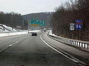
, and ends at an interchange with New York State Route 352 (NY 352) in Elmira, New York
, while the second extends from I-81 east of Binghamton to NY 79
in Windsor
. When projects to upgrade the existing NY 17
to Interstate Highway standards
are completed, I-86 will extend from I-90 near Erie to the New York State Thruway
(I-87
) in Woodbury
. The current and future alignment of I-86 is known as the Southern Tier Expressway west of I-81 in Binghamton and the Quickway east of I-81.
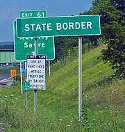
I-86 currently travels 6.99 miles (11.25 km) in Pennsylvania and 199.86 miles (321.64 km) in New York. Except for a section of about 1.5 miles (2.4 km) that dips into Pennsylvania near Sayre, Pennsylvania
, the rest of I-86 will be in New York. That section of NY 17 is maintained by the New York State Department of Transportation
, however. The Southern Tier Expressway section of I-86 and NY 17 comprises Corridor T of the Appalachian Development Highway System
. I-86 connects to U.S. Route 219 in Salamanca
, I-390
near Avoca
and U.S. Route 15 (future Interstate 99) just west of Corning
.
Most of the Quickway and the Southern Tier Expressway was built in stages from the 1950s to the 1980s. The I-86 designation was officially assigned on December 3, 1999, to the entirety of then-Pennsylvania Route 17 and the westernmost 177 miles (285 km) of NY 17. It has been extended eastward as more sections of the existing NY 17 freeway have been upgraded to Interstate Highway standards, first to NY 14
in Horseheads
in 2004 and to its current eastern terminus at NY 352 in Elmira in 2008. The segment of NY 17 between I-81 and NY 79 was designated as part of I-86 in 2006.
|PA
|-
|NY
|-
|Total
|}
. It heads to the southeast, meeting Pennsylvania Route 89 at exit 3 before curving to the east and crossing into New York
, where it becomes concurrent
to New York State Route 17 (NY 17). The freeway heads generally east–west across southwest Chautauqua County
, serving the hamlet of Findley Lake and the village of Sherman
via NY 426
and NY 76
, respectively, as it proceeds toward Chautauqua Lake
.
After crossing Chautauqua Lake, I-86 merges into an older section of freeway at exit 10 near Bemus Point
; this freeway is now NY 954J northwest of the newer extension. NY 954J runs into NY 430
, which (along with NY 394
) carried NY 17 to Westfield
before the 1980s extension. From Bemus Point to Jamestown
(exit 12), I-86 parallels the old NY 17 - now NY 430
- along the northeast shore of Chautauqua Lake. The Erie Railroad
extension to Chicago
(built as the Atlantic and Great Western Railroad
) comes into Jamestown from the southwest, and parallels I-86 to its junction with the Erie's original main line to Dunkirk at Salamanca
.
From Jamestown to Salamanca, the old NY 17 (now mostly NY 394
), the new I-86 and the railroad run generally parallel through river valleys. The transportation routes run along the Chadakoin River, Conewango Creek
and Little Conewango Creek to Steamburg
(exit 17), cutting east to the Allegheny River
at Coldspring
there. The valley of the Allegheny takes the routes to Salamanca (exit 20), where the railroads merged, and beyond to Olean
(Exits 25 and 26). From Salamanca to Olean, the old NY 17 is now NY 417
. At Olean, the Allegheny River and NY 417 (old NY 17) continue southeast, while I-86 and the Erie Railroad head northeast. NY 417 does not return to I-86 until exit 44 near Painted Post
, and the Erie switches between the two alignments several times.
(exit 28). From Cuba to Friendship
(exit 29), they run through a valley and over a summit, then following the Van Campen Creek northeast to Belvidere (exit 30). At Belvidere, the Erie turns southeast to meet NY 417 at Wellsville
, but I-86 continues northeast through the valleys of the Genesee River
and Angelica Creek
to Angelica
(exit 31), and then east along the Angelica Creek, over a summit which is the highest point on the Interstate, and along the Karr Valley Creek to Almond
(exit 33). This summit, at 2,110 feet (634 m) above sea level
, is the highest point along I-86, located between exits 32 (West Almond
) and 33 and marked with a sign.
At Almond, I-86 rejoins the Erie Railroad, passing through the Canacadea Creek valley about halfway to Hornellsville
. However, where the railroad turns southeast to Hornellsville, I-86 continues northeast across a summit and into the wide Canisteo River
valley (exit 34). It leaves the valley along the Carrington Creek, but quickly turns east across a summit to follow the Big Creek and cross another summit to Howard
(exit 35). I-86 runs alongside Goff Creek from Howard to the wide Cohocton River
valley, where it meets the south end of Interstate 390 (exit 36) near Avoca and turns southeast through that valley, parallel to the Erie's Rochester
-Painted Post
line (Buffalo, New York
and Erie Railroad
).
I-86, NY 415
(old US 15) and the Erie branch all run southeast along the Cohocton River past Bath
(exit 38) to Painted Post
(exit 44), now the north end of US 15. NY 417 - old NY 17 - also ends at exit 44, while NY 415 continues east into Corning (exits 45–46). From Painted Post through Corning to Big Flats
(exit 49), I-86, NY 352
(old NY 17) and the Erie Railroad run through the Chemung River
valley. NY 352 begins at exit 45, west of downtown Corning, and is a recently bypassed four-lane road through Corning. East of East Corning (exit 48), the freeway was built as an on-the-spot upgrade of the old NY 17.
 At Big Flats, the Chemung River (and NY 352) turns southeast to downtown Elmira
, while I-86 and the Erie continue east-northeast alongside Singsing Creek to the vicinity of Elmira/Corning Regional Airport. The highway continues into the Horseheads
, where it becomes an elevated highway through the use of a large arrangement of embankments and bridges. It connects to NY 14
and NY 13
via exits 52 and 54, respectively, before turning south to follow Newtown Creek into Elmira. Just east of the city's downtown district, I-86 meets NY 352
(exit 56). The I-86 designation ends here; however, a 9.9 miles (15.9 km) section of NY 17 just east of Binghamton is also designated as I-86, creating a temporary gap in the designation. The Broome County
segment runs from Interstate 81 at exit 75 in Kirkwood
to NY 79
at exit 79 in Windsor
.
, which extended from Westfield
to New Jersey
via Harriman
when it was assigned in 1924. Much of NY 17 followed a routing parallel or identical to that of the modern Southern Tier Expressway and Quickway; however, it followed a more northerly routing between Westfield and Bemus Point
(via modern NY 394
and NY 430
) and a more southerly track from Belvidere to Corning
(via what is now NY 19
and NY 417
). NY 17 was realigned as part of the 1930 renumbering of state highways in New York to travel directly from Olean
to Wellsville
on modern NY 417, located well to the south of today's Southern Tier Expressway.
 By the late 1940s, the portion of NY 17 through the Catskill Mountains
and Orange
and Rockland
Counties had become prone to massive traffic jams due to both its winding and narrow composition and congestion in the villages and hamlets along the highway. As a result, the state of New York
began making plans to construct an expressway leading from the New York State Thruway
at Harriman to the Catskills. Construction of the NY 17 freeway began in 1947 in the Hudson Valley town of Wallkill
. The first section of the new freeway, a bypass of Middletown
between Fair Oaks (exit 118A, since removed) and Goshen
(exit 123), opened to traffic in July 1951 as a realignment of NY 17. In 1954, several severe accidents occurred along parts of the surface NY 17, compelling the state to make constructing the freeway, dubbed the "Quickway", a higher priority.
The road was extended east first, reaching Chester
(exit 127) in October 1954 and the Thruway near Harriman in August 1955. To the west, a section of the highway through Sullivan
and Delaware
Counties was built over the right-of-way of the defunct Ontario & Western Railway
. Most of the Sullivan County section of the Quickway was completed during the 1950s, with the first section within the county—between Rock Hill (exit 108) and Wurtsboro
(exit 114)—opening in December 1956. A second section, from Ferndale (exit 101) to north of Liberty
(exit 98), was completed in July 1958. The gap between Wurtsboro and Fair Oaks in Orange County
was filled on October 23, 1958, while the section between Ferndale and Rock Hill was completed in two stages. The section east of modern exit 104 in Monticello
was opened in July 1959; the part north of that point opened in December 1960.
By 1969, with the assistance of federal funding from the Appalachian Regional Commission
procured by New York's U.S. Senator Robert F. Kennedy
, the 130 miles (209 km) route provided nonstop access between Harriman and Binghamton
, from the New York State Thruway (Interstate 87) to Interstate 81. Despite flaws in the highway's design — it included a grade-level railroad crossing near Fair Oaks
(since removed) and two stretches with intersections and driveway access — the Quickway succeeded in easing travel through southern New York, cutting the driving time in half and the accident rate by 70 percent.
 In February 1953, New York Governor Thomas Dewey
proposed constructing four "superhighways" across the state to supplement the New York State Thruway. One of the four proposed limited-access highways would cut across the Southern Tier
, linking Interstate 90 in the west to Binghamton in the east. The first segments of what became known as the Southern Tier Expressway, a westward continuation of the Quickway, were completed in the mid-1960s. Four sections were opened to traffic at this time: Kennedy (exit 14) to Randolph
(16); Coldspring
(17) to western Salamanca
(20); Campbell
(41) to Corning
(45); and East Corning (48) to Lowman (58), parts of which were built as a surface highway. A fifth section, from Owego
(65) to Johnson City
(69), opened in early 1969. The portion of the expressway between Nichols
(exit 62) and Owego was opened to traffic on October 3, 1969.
Four more segments of the Southern Tier Expressway were completed over the course of the next three years. By 1972, the gaps between Randolph and Coldspring and from Johnson City to I-81 in Binghamton were filled while the expressway was extended west from Kennedy to Falconer
(exit 13) and east from Lowman to Waverly
(exit 60). The missing link between Waverly and Nichols was completed by 1974. The portion of the freeway in and around Waverly was originally planned to be built on the right-of-way of the Delaware, Lackawanna and Western Railroad
through southern Waverly; however, the plan was scrapped in favor of a more southerly alignment that passed through the borough of South Waverly, Pennsylvania
. The realignment saved $2 million (equivalent to $ in ) in construction costs and spared a handful of industries in the highway's proposed path. Both state legislatures approved the realignment in 1966 after New York agreed to maintain the section of the freeway in Pennsylvania. As part of an agreement made between the two states, Pennsylvania acquired the necessary right-of-way and easements for the freeway at the expense of New York.
Three other segments of the freeway were completed by 1974. Two of the three—from Jamestown
(exit 11) and Falconer and between Almond
(33) and Campbell—were extensions of pre-existing sections while the third, connecting Allegany
(24) to Hinsdale
(27), was isolated from the other portions of the highway. This was only temporary, however, as the freeway was completed between Hinsdale and Belvidere (exit 30) by January 1975 and opened to traffic from Belvidere to Almond on January 30, 1975. The Southern Tier Expressway was extended westward to Bemus Point
by 1977, initially utilizing what is now NY 954J. In the early 1980s, work began on a westward extension to the vicinity of Erie, Pennsylvania
. The Findley Lake (exit 4) – Bemus Point (10) segment was completed by 1985 while the portion from I-90 east of Erie to Findley Lake was opened by 1989. From I-90 to exit 8, the freeway was initially built as a super two
highway, with both directions utilizing what are now the eastbound lanes. The westbound lanes were built at a cost of $34 million (equivalent to $ in ) and opened to traffic on October 2, 1997.
, who objected to the freeway's proposed routing through the Allegany Indian Reservation. On June 29, 1976, the state of New York made an agreement with the Seneca nation that paid approximately $1.8 million (equivalent to $ in ) to the Seneca nation and property owners for the 795 acres (322 ha) of land comprising the highway's proposed routing. In addition, the state ceded 795 acres (3.2 km²) of land to the Seneca nation—750 of which were taken from the adjacent Allegany State Park
—and agreed to support several tax and regulatory exemptions for the Senecas. The transaction was completed in September 1981, and construction on the segment began in 1982. The portion of the expressway between exits 20 and 21 was completed by 1985.
On July 21, 1985, construction was halted by protesting Seneca Indians who did not accept the authority of the Seneca nation. The protest was organized in part by two owners of property in the path of the highway and involved the construction of an encampment on the right-of-way of the Southern Tier Expressway. The state had conducted studies on realigning the highway to bypass the disputed section; however, the Indians vacated the encampment five days later. A temporary injunction prohibiting further disruptions of the highway's construction was issued in early August, allowing work on the Salamanca – Seneca Junction (exit 23) section of the expressway to resume on August 13. This segment was completed by 1989 while the last section between Seneca Junction and Allegany was opened to traffic by 1995.
Work on the Corning Bypass, a freeway around the northern and eastern fringes of the city of Corning, began in the mid-1980s. The first segment of the highway—between NY 414
(exit 46) and East Corning—was completed by 1989 while the rest opened in the mid-1990s. The completion of the Corning Bypass, the last substantial gap in the freeway, created a continuous, mostly limited-access highway between Erie, Pennsylvania, and Harriman, New York. The completed highway, designated as Pennsylvania Route 17 (PA 17) and NY 17, serves as a time-saving, non-toll shortcut past the Thruway for motorists going from the New York City
area to Ohio
and points west. In fact, the New York State Thruway Authority initially opposed the highway's construction, fearing the loss of toll revenue on its own route from motorists shunpiking
via the free alternate route.
. In 1998, all of PA 17 and the portion of NY 17 from the Pennsylvania state line to Harriman were designated "High Priority Corridor 36" in the Transportation Equity Act for the 21st Century
(TEA-21). New York politicians, including Senator Daniel Patrick Moynihan
, and businessmen backed the move in the hope that an efficient, high-speed roadway would inspire companies to do business in the state's southern counties. Shortly after the passage of TEA-21, Corridor 36 was legislatively designated as Interstate 86 in an amendment to the bill. The American Association of State Highway and Transportation Officials
formally approved the designation on November 6, 1998, as "Future I-86".
On December 3, 1999, all of PA 17 and the westernmost 177 miles (285 km) of NY 17 were officially designated as I-86 by the Federal Highway Administration
(FHWA) following improvements to bring the roadway up to Interstate Highway standards
. The designation was extended 8 miles (13 km) eastward to NY 14
in Horseheads
on January 28, 2004, after that section had been brought up to standards. On May 1, 2006, the 10 miles (16 km) portion of NY 17 from I-81 in Binghamton east to NY 79
in Windsor
was designated as part of I-86 following the elimination of at-grade intersections and the reconstruction of exit ramps along the stretch. The completion of the $30 million project increased the total mileage of I-86 to 195 miles (314 km) and created a temporary gap in the designation.
In Horseheads, a $60 million project to elevate the highway and remove at-grade intersections in the village between NY 14 (exit 52) and NY 13
(exit 54) began in April 2004 and was completed on August 20, 2007. The New York State Department of Transportation
(NYSDOT) subsequently sought permission from FHWA to extend I-86 over the new bypass and the existing NY 17 freeway to NY 352
in Elmira; it was granted on March 28, 2008, adding another 5.9 miles (9.5 km) to the route.
is slated to be designated as I-86 in about 2012 after the remaining at-grade sections are eliminated and the highway is brought up to Interstate Highway standards
. Temporary signs mark the route as "Future Interstate 86" where it is not already designated as I-86. Cost estimates for the I-86 renovation range from $550 million to $900 million. Two projects to improve sub-standard sections of NY 17 are currently in development or under construction. The first covers the 5.5 miles (8.9 km) of NY 17 between the current east end of I-86 and exit 58 in Lowman. As part of the project, three discontinuous sections of County Route 60 (CR 60)—Brant Road, Oneida Road, and Old NY 17—will be linked together and several at-grade intersections on NY 17 will be eliminated. Two of the three at-grade junctions—the east junction with Brant Road and the west junction with Oneida Road—were permanently closed on March 24, 2010, to allow construction to begin on the new alignment of CR 60 between the two locations. The $84.7 million project is expected to be completed in mid-2012.
The second of the two involves improvements to the interchange with Interstate 81 in Binghamton near the stretch named "Kamikaze Curve
". Work on the Prospect Mountain project, as it is known by NYSDOT, is projected to begin in mid-2011 and last until early 2013. The projected total cost of the project is $193.2 million. Other projects that need to be completed to extend I-86 eastward include the removal of at-grade intersections from exit 58 to exit 59 in Chemung
, the elimination of at-grade intersections in the Catskills between exits 84 and 87 and between exits 97 and 99, and other interchange
improvements in the Catskills.
|rowspan=3|Erie
|rowspan=3|Greenfield Township
|0.00
|1
|
|Westbound exit and eastbound entrance; signed as exits 1A (west) and 1B (east)
|-
|
|3
|
|
|-
|rowspan=2|6.99
0.00
|rowspan=2 colspan=3 align="center"|Pennsylvania – New York state line
|-
|rowspan=11|Chautauqua
|rowspan=2|Mina
|-
|1.03
|4
|
|
|-
|Sherman
|9.17
|6
|
|
|-
|rowspan=2|North Harmony
|15.34
|7
|Panama
, Chautauqua Institution
|
|-
|18.86
|8
|
|
|-
|rowspan=2|Ellery
|20.22
|9
|
|Eastbound exit and westbound entrance
|-
|20.29
|10
|
|
|-
|rowspan=3|Ellicott
|26.23
|11
|Strunk Road (NY 953B)
|
|-
|28.00
|12
|
|
|-
|30.69
|13
|
|
|-
|Poland
|36.04
|14
|
|
|-
|rowspan=12|Cattaraugus
|Town of Randolph
|39.33
|15
|School House Road (NY 953A)
|
|-
|Village of Randolph
|41.38
|16
|West Main Street (NY 952M) – Randolph, Gowanda
|
|-
|rowspan=2|Coldspring
|47.88
|17
|
|
|-
|50.61
|18
|
|
|-
|Red House
|54.43
|19
|Allegany State Park
, Red House Area
|
|-
|rowspan=2|Salamanca
|58.14
|20
|
|
|-
|60.45
|21
|
|West end of US 219 overlap
|-
|Carrollton
|67.52
|23
|
|East end of US 219 overlap
|-
|Allegany
|74.07
|24
|
|
|-
|rowspan=2|Olean
|77.27
|25
|Buffalo Street (NY 954E) – Olean
|
|-
|78.77
|26
|
|
|-
|Hinsdale
|84.69
|27
|
|
|-
|rowspan=6|Allegany
|Cuba
|91.35
|28
|
|
|-
|Friendship
|98.72
|29
|
|
|-
|Amity
|104.45
|30
|
|
|-
|Angelica
|108.55
|31
|Angelica
|
|-
|West Almond
|115.78
|32
|West Almond
|
|-
|Almond
|123.61
|33
|
|
|-
|rowspan=17|Steuben
|Hornellsville
|128.30
|34
|
|Signed as exits 34S (south) and 34N (north)
|-
|Howard
|137.98
|35
|Howard
(NY 962B)
|
|-
|Avoca
|145.17
|36
|
|
|-
|Town of Bath
|146.30
|37
|
|
|-
|Village of Bath
|149.50
|38
|
|
|-
|rowspan=2|Town of Bath
|152.61
|39
|
|
|-
|156.40
|40
|
|
|-
|rowspan=2|Campbell
|161.20
|41
|
|
|-
|165.24
|42
|Coopers Plains (NY 960M)
|
|-
|Erwin
|167.51
|43
|
|
|-
|rowspan=2|Painted Post
|168.64
|44A
|
|Northern Terminus of US 15
|-
|168.64
|44B
|
|
|-
|rowspan=2|Riverside
|169.02
|45
|
|Eastbound exit and westbound entrance
|-
|
|45
|
|Westbound exit and eastbound entrance
|-
|rowspan=3|Corning
|171.49
|46
|
|
|-
|174.20
|47
|
|
|-
|176.57
|48
|
|
|-
|rowspan=9|Chemung
|rowspan=4|Big Flats
|178.85
|49
|Big Flats
|
|-
|
|50
|
|
|-
|182.30
|51A
|Chambers Road – Shopping Malls, Elmira/Corning Regional Airport
|
|-
|
|51B
|Colonial Drive – Shopping Mall
|Westbound exit only
|-
|rowspan=4|Horseheads
|
|52A
|Commerce Center Road (NY 962E)
|No westbound exit
|-
|184.35
|52B
|
|Signed as exits 52B (south) and 52N (north) westbound
|-
|
|53
|Horseheads
|
|-
|185.72
|54
|
|
|-
|Elmira
|189.90
|56
|
|
|-
|colspan=6 align="center"|Temporary gap in I-86 designation; see NY 17 for exits 57 through 74
|-
|rowspan=5|Broome
|rowspan=2|Kirkwood
|249.62
|75
|
|Exit number signed westbound only
|-
|251.31
|76
|Haskins Road / Foley Road
|
|-
|rowspan=2|Windsor town
|
|77
|West Windsor
|
|-
|256.25
|78
|Dunbar Road – Occanum
|
|-
|Windsor village
|259.64
|79
|
|
|-
|colspan=6 align="center"|Temporary east end of I-86; highway continues east as NY 17
Pennsylvania
The Commonwealth of Pennsylvania is a U.S. state that is located in the Northeastern and Mid-Atlantic regions of the United States. The state borders Delaware and Maryland to the south, West Virginia to the southwest, Ohio to the west, New York and Ontario, Canada, to the north, and New Jersey to...
and southern New York
New York
New York is a state in the Northeastern region of the United States. It is the nation's third most populous state. New York is bordered by New Jersey and Pennsylvania to the south, and by Connecticut, Massachusetts and Vermont to the east...
in the United States
United States
The United States of America is a federal constitutional republic comprising fifty states and a federal district...
. The highway currently exists in two segments: the longer of the two begins at an interchange with I-90 east of Erie, Pennsylvania
Erie, Pennsylvania
Erie is a city located in northwestern Pennsylvania in the United States. Named for the lake and the Native American tribe that resided along its southern shore, Erie is the state's fourth-largest city , with a population of 102,000...
, and ends at an interchange with New York State Route 352 (NY 352) in Elmira, New York
Elmira, New York
Elmira is a city in Chemung County, New York, USA. It is the principal city of the 'Elmira, New York Metropolitan Statistical Area' which encompasses Chemung County, New York. The population was 29,200 at the 2010 census. It is the county seat of Chemung County.The City of Elmira is located in...
, while the second extends from I-81 east of Binghamton to NY 79
New York State Route 79
New York State Route 79 is an east–west state highway in the Southern Tier of New York, United States. The western terminus of the route is at the intersection with NY 414 near the southern end of Seneca Lake east of Watkins Glen...
in Windsor
Windsor (village), New York
Windsor is a village in Broome County, New York, United States. The population was 901 at the 2000 census. It is part of the Binghamton Metropolitan Statistical Area....
. When projects to upgrade the existing NY 17
New York State Route 17
New York State Route 17 is a state highway that extends for through the Southern Tier and Downstate regions of New York in the United States...
to Interstate Highway standards
Interstate Highway standards
Standards for Interstate Highways in the United States are defined by the American Association of State Highway and Transportation Officials in the publication A Policy on Design Standards - Interstate System...
are completed, I-86 will extend from I-90 near Erie to the New York State Thruway
New York State Thruway
The New York State Thruway is a system of limited-access highways located within the state of New York in the United States. The system, known officially as the Governor Thomas E. Dewey Thruway for former New York Governor Thomas E. Dewey, is operated by the New York State Thruway Authority and...
(I-87
Interstate 87
Interstate 87 is a Interstate Highway located entirely within New York State in the United States of America. I-87 is the longest intrastate Interstate highway in the Interstate Highway System. Its southern end is at the Bronx approaches of the Robert F. Kennedy Bridge in New York City...
) in Woodbury
Woodbury, Orange County, New York
Woodbury is a town and village in Orange County, New York, United States. The town population was 9,460 at the 2000 census. The village was incorporated in 2006 and comprises all of the town that is not part of the village of Harriman. The region was once called Woodbury Clove...
. The current and future alignment of I-86 is known as the Southern Tier Expressway west of I-81 in Binghamton and the Quickway east of I-81.
I-86 currently travels 6.99 miles (11.25 km) in Pennsylvania and 199.86 miles (321.64 km) in New York. Except for a section of about 1.5 miles (2.4 km) that dips into Pennsylvania near Sayre, Pennsylvania
Sayre, Pennsylvania
Sayre is the largest borough in Bradford County, Pennsylvania, northwest of Scranton. In the past, various iron products were made there. In 1900, 5,243 people lived there; in 1910, 6,426 people lived there, and in 1940, 7,569 persons made their homes in Sayre. The population was 5,813 at the 2000...
, the rest of I-86 will be in New York. That section of NY 17 is maintained by the New York State Department of Transportation
New York State Department of Transportation
The New York State Department of Transportation is responsible for the development and operation of highways, railroads, mass transit systems, ports, waterways and aviation facilities in the U.S...
, however. The Southern Tier Expressway section of I-86 and NY 17 comprises Corridor T of the Appalachian Development Highway System
Appalachian Development Highway System
The Appalachian Development Highway System is part of the Appalachian Regional Commission in the United States. See: .-History:...
. I-86 connects to U.S. Route 219 in Salamanca
Salamanca (city), New York
Salamanca is a city in Cattaraugus County, New York, United States, located inside the Allegany Indian Reservation. The population was 6,097 at the 2000 census.-Geography:...
, I-390
Interstate 390
Interstate 390 is a north–south auxiliary Interstate Highway located entirely within New York in the United States. The southern terminus of the route is at the Southern Tier Expressway in the town of Avoca. Its northern terminus is at I-490 in Rochester...
near Avoca
Avoca (village), New York
Avoca is a village located in the Town of Avoca in Steuben County, New York, United States. The population was 1,008 at the 2000 census.The Village of Avoca is located in the eastern part of the town, northwest of Bath, New York.- History :...
and U.S. Route 15 (future Interstate 99) just west of Corning
Corning (city), New York
Corning is a city in Steuben County, New York, United States, on the Chemung River. The population was 10,842 at the 2000 census. It is named for Erastus Corning, an Albany financier and railroad executive who was an investor in the company that developed the community.- Overview :The city of...
.
Most of the Quickway and the Southern Tier Expressway was built in stages from the 1950s to the 1980s. The I-86 designation was officially assigned on December 3, 1999, to the entirety of then-Pennsylvania Route 17 and the westernmost 177 miles (285 km) of NY 17. It has been extended eastward as more sections of the existing NY 17 freeway have been upgraded to Interstate Highway standards, first to NY 14
New York State Route 14
New York State Route 14 is a state highway located in western New York in the United States. Along with NY 19, it is one of two routes to transect the state in a north–south fashion between the Pennsylvania border and Lake Ontario...
in Horseheads
Horseheads (village), New York
Horseheads is a village in Chemung County, New York, USA. The population was 6,461 at the 2010 census. The name is derived from the number of bleached skulls of pack horses left behind by the Sullivan Expedition....
in 2004 and to its current eastern terminus at NY 352 in Elmira in 2008. The segment of NY 17 between I-81 and NY 79 was designated as part of I-86 in 2006.
Route description
|-|PA
Pennsylvania
The Commonwealth of Pennsylvania is a U.S. state that is located in the Northeastern and Mid-Atlantic regions of the United States. The state borders Delaware and Maryland to the south, West Virginia to the southwest, Ohio to the west, New York and Ontario, Canada, to the north, and New Jersey to...
|-
|NY
New York
New York is a state in the Northeastern region of the United States. It is the nation's third most populous state. New York is bordered by New Jersey and Pennsylvania to the south, and by Connecticut, Massachusetts and Vermont to the east...
|-
|Total
|}
Pennsylvania to Olean
I-86 begins at an interchange with Interstate 90 in a relatively flat area of northwestern PennsylvaniaPennsylvania
The Commonwealth of Pennsylvania is a U.S. state that is located in the Northeastern and Mid-Atlantic regions of the United States. The state borders Delaware and Maryland to the south, West Virginia to the southwest, Ohio to the west, New York and Ontario, Canada, to the north, and New Jersey to...
. It heads to the southeast, meeting Pennsylvania Route 89 at exit 3 before curving to the east and crossing into New York
New York
New York is a state in the Northeastern region of the United States. It is the nation's third most populous state. New York is bordered by New Jersey and Pennsylvania to the south, and by Connecticut, Massachusetts and Vermont to the east...
, where it becomes concurrent
Concurrency (road)
A concurrency, overlap, or coincidence in a road network is an instance of one physical road bearing two or more different highway, motorway, or other route numbers...
to New York State Route 17 (NY 17). The freeway heads generally east–west across southwest Chautauqua County
Chautauqua County, New York
-Major highways:* Interstate 86/New York State Route 17 * Interstate 90 * U.S. Route 20* U.S. Route 62* New York State Route 5* New York State Route 39* New York State Route 60* New York State Route 394...
, serving the hamlet of Findley Lake and the village of Sherman
Sherman (village), New York
Sherman is a village in the town of Sherman, Chautauqua County, New York, USA. The village lies in the northern part of the town at intersections of Routes 15, 18, NY-76 and NY-430. The population was 714 at the 2000 census.- History :...
via NY 426
New York State Route 426
New York State Route 426 is a state highway located entirely within Chautauqua County, New York, United States. It runs just over from one section of the Pennsylvania state line to another, passing through two small hamlets and providing the Southern Tier Expressway with its westernmost...
and NY 76
New York State Route 76
New York State Route 76 is located entirely within Chautauqua County, New York, United States. It runs north–south from NY 474 in the hamlet of North Clymer in the town of Clymer at its southern end to NY 5 along the Lake Erie shoreline in the town of Ripley...
, respectively, as it proceeds toward Chautauqua Lake
Chautauqua Lake
Chautauqua Lake is located entirely within Chautauqua County, New York, USA. The lake is approximately long and wide at its greatest width. The surface area is approximately 13,000 acres . The maximum depth is about 78 feet...
.
After crossing Chautauqua Lake, I-86 merges into an older section of freeway at exit 10 near Bemus Point
Bemus Point, New York
Bemus Point is a village in Chautauqua County, New York, United States. The village is within the Town of Ellery and located along the eastern shore of Chautauqua Lake. The population was 340 at the 2000 census...
; this freeway is now NY 954J northwest of the newer extension. NY 954J runs into NY 430
New York State Route 430
New York State Route 430 is a state highway located entirely within Chautauqua County, New York, in the United States. Its western terminus is located at the Pennsylvania state line near the hamlet of Findley Lake in the town of Mina. The eastern terminus is located in the city of Jamestown...
, which (along with NY 394
New York State Route 394
New York State Route 394 is a state highway located within Cattaraugus and Chautauqua Counties in southwestern New York, United States. Its western terminus is located on the shore of Lake Erie at an intersection with NY 5 in the Westfield hamlet of Barcelona...
) carried NY 17 to Westfield
Westfield (village), New York
Westfield is a village in Chautauqua County, New York, United States. USA. The population was 3,481 at the 2010 census.The Village of Westfield lies within the Town of Westfield in the northern part of the county...
before the 1980s extension. From Bemus Point to Jamestown
Jamestown, New York
Jamestown is a city in Chautauqua County, New York in the United States. The population was 31,146 at the 2010 census.The City of Jamestown is adjacent to Town of Ellicott and is at the southern tip of Chautauqua Lake...
(exit 12), I-86 parallels the old NY 17 - now NY 430
New York State Route 430
New York State Route 430 is a state highway located entirely within Chautauqua County, New York, in the United States. Its western terminus is located at the Pennsylvania state line near the hamlet of Findley Lake in the town of Mina. The eastern terminus is located in the city of Jamestown...
- along the northeast shore of Chautauqua Lake. The Erie Railroad
Erie Railroad
The Erie Railroad was a railroad that operated in New York State, New Jersey, Pennsylvania, Ohio, Indiana, and Illinois, originally connecting New York City with Lake Erie...
extension to Chicago
Chicago
Chicago is the largest city in the US state of Illinois. With nearly 2.7 million residents, it is the most populous city in the Midwestern United States and the third most populous in the US, after New York City and Los Angeles...
(built as the Atlantic and Great Western Railroad
Atlantic and Great Western Railroad
The Atlantic and Great Western Railroad began as three separate railroads: the Erie and New York City Railroad based in Jamestown, New York; the Meadville Railroad based in Meadville, Pennsylvania ; and the Franklin and Warren Railroad based in Franklin Mills, Ohio...
) comes into Jamestown from the southwest, and parallels I-86 to its junction with the Erie's original main line to Dunkirk at Salamanca
Salamanca (city), New York
Salamanca is a city in Cattaraugus County, New York, United States, located inside the Allegany Indian Reservation. The population was 6,097 at the 2000 census.-Geography:...
.
From Jamestown to Salamanca, the old NY 17 (now mostly NY 394
New York State Route 394
New York State Route 394 is a state highway located within Cattaraugus and Chautauqua Counties in southwestern New York, United States. Its western terminus is located on the shore of Lake Erie at an intersection with NY 5 in the Westfield hamlet of Barcelona...
), the new I-86 and the railroad run generally parallel through river valleys. The transportation routes run along the Chadakoin River, Conewango Creek
Conewango Creek
Conewango Creek is a tributary of the Allegheny River in Pennsylvania and western New York in the United States.The creek's drainage covers much of southeastern Chautauqua County, New York and southwestern Cattaraugus County, New York. The creek's most notable tributary is the Chadakoin River,...
and Little Conewango Creek to Steamburg
Steamburg, New York
Steamburg is a hamlet in the town of Coldspring in Cattaraugus County, New York, United States. The community is located at the eastern terminus of New York State Route 394, at I-86 exit 17. Also converging on the hamlet is New York State Reference Route 950A Steamburg is a hamlet in the town of...
(exit 17), cutting east to the Allegheny River
Allegheny River
The Allegheny River is a principal tributary of the Ohio River; it is located in the Eastern United States. The Allegheny River joins with the Monongahela River to form the Ohio River at the "Point" of Point State Park in Downtown Pittsburgh, Pennsylvania...
at Coldspring
Coldspring, New York
Coldspring is a town in Cattaraugus County, New York, United States. It is located in the southwest part of the county, west of the City of Salamanca.- History :The first settler arrived around 1818....
there. The valley of the Allegheny takes the routes to Salamanca (exit 20), where the railroads merged, and beyond to Olean
Olean, New York
Olean is a city in Cattaraugus County, New York, United States. Olean is the largest city in Cattaraugus County, and serves as the financial, business, transportation and entertainment center of the county. It is one of the principal cities of the Southern Tier region of New York.The city is...
(Exits 25 and 26). From Salamanca to Olean, the old NY 17 is now NY 417
New York State Route 417
New York State Route 417 is an east–west state highway located in the Southern Tier of New York in the United States. It begins at exit 20 of the Southern Tier Expressway in the city of Salamanca and ends at a junction with NY 415 in Painted Post, west of the city of Corning...
. At Olean, the Allegheny River and NY 417 (old NY 17) continue southeast, while I-86 and the Erie Railroad head northeast. NY 417 does not return to I-86 until exit 44 near Painted Post
Painted Post, New York
Painted Post is a village in Steuben County, New York, United States. The village is in the town of Erwin, west of the city of Corning. The population was 1,842 at the 2000 census. The name comes from a painted and carved post found by explorers at the junction of three local rivers...
, and the Erie switches between the two alignments several times.
Olean to Elmira
I-86 and the old Erie line (now part of the Western New York and Pennsylvania Railroad) run northeast along the valleys of the Olean Creek and Oil Creek to CubaCuba (village), New York
Cuba is a village in Allegany County, New York, United States. The population was 1,633 at the 2000 census.The Village of Cuba is in the western part of the Town of Cuba at the junction of Routes 305 and 446 on Oil Creek.- History :...
(exit 28). From Cuba to Friendship
Friendship, New York
Friendship is a town in Allegany County, New York, USA. The population was 1,927 at the 2000 census. The town's name was adopted to mark the resolution of earlier conflicts....
(exit 29), they run through a valley and over a summit, then following the Van Campen Creek northeast to Belvidere (exit 30). At Belvidere, the Erie turns southeast to meet NY 417 at Wellsville
Wellsville (village), New York
Wellsville is a Village in Allegany County of New York State. At the top of the Eastern Triple Continental Divide, in south-central wooded and rural Allegany County, it is the largest population and business center in a 30-mile radius. The population was 5,171 at the 2000 census...
, but I-86 continues northeast through the valleys of the Genesee River
Genesee River
The Genesee River is a North American river flowing northward through the Twin Tiers of Pennsylvania and New York. The river provided the original power for the Rochester area's 19th century mills and still provides hydroelectric power for downtown Rochester....
and Angelica Creek
Angelica Creek
Angelica Creek is a tributary of the Schuylkill River in Berks County, Pennsylvania in the United States.Angelica Creek joins the Schuylkill River at Kenhorst.-References:*Gertler, Edward. Keystone Canoeing, Seneca Press, 2004. ISBN 0-9749692-0-6...
to Angelica
Angelica (village), New York
Angelica is a village in Allegany County, New York, USA. The population was 903 at the 2000 census. The village and the town are named after Angelica Church, a daughter of General Philip Schuyler and wife of John Barker Church....
(exit 31), and then east along the Angelica Creek, over a summit which is the highest point on the Interstate, and along the Karr Valley Creek to Almond
Almond (village), New York
Almond is a village located in the Town of Almond in Allegany County, New York, United States. The population was 461 at the 2000 census.Because the Village of Almond is located on the county line, a small part is in the Town of Hornellsville in Steuben County, New York.-Geography:According to the...
(exit 33). This summit, at 2,110 feet (634 m) above sea level
Sea level
Mean sea level is a measure of the average height of the ocean's surface ; used as a standard in reckoning land elevation...
, is the highest point along I-86, located between exits 32 (West Almond
West Almond, New York
West Almond is a town in Allegany County, New York, United States. The population was 353 at the 2000 census.The Town of West Almond is centrally located in the eastern part of the county and is west of Hornell, New York.- History :...
) and 33 and marked with a sign.
At Almond, I-86 rejoins the Erie Railroad, passing through the Canacadea Creek valley about halfway to Hornellsville
Hornellsville, New York
Hornellsville is a town in Steuben County, New York, United States. United States. The population was 4,042 at the 2000 census. The name is taken from a prominent pioneer family....
. However, where the railroad turns southeast to Hornellsville, I-86 continues northeast across a summit and into the wide Canisteo River
Canisteo River
The Canisteo River is a tributary of the Tioga River in western New York in the United States. It drains a dissected plateau, a portion of the northern Allegheny Plateau southwest of the Finger Lakes region, in the far northwestern reaches of the watershed of the Susquehanna River.It rises in the...
valley (exit 34). It leaves the valley along the Carrington Creek, but quickly turns east across a summit to follow the Big Creek and cross another summit to Howard
Howard, New York
Howard is a town in Steuben County, New York, United States. The population was 1,430 at the 2000 census.The Town of Howard is in the west-central part of the county, east of Hornell, New York.- History :...
(exit 35). I-86 runs alongside Goff Creek from Howard to the wide Cohocton River
Cohocton River
The Cohocton River is a tributary of the Chemung River in western New York in the United States. Via the Chemung River, it is part of the Susquehanna River watershed, flowing to Chesapeake Bay...
valley, where it meets the south end of Interstate 390 (exit 36) near Avoca and turns southeast through that valley, parallel to the Erie's Rochester
Rochester, New York
Rochester is a city in Monroe County, New York, south of Lake Ontario in the United States. Known as The World's Image Centre, it was also once known as The Flour City, and more recently as The Flower City...
-Painted Post
Painted Post, New York
Painted Post is a village in Steuben County, New York, United States. The village is in the town of Erwin, west of the city of Corning. The population was 1,842 at the 2000 census. The name comes from a painted and carved post found by explorers at the junction of three local rivers...
line (Buffalo, New York
Buffalo, New York
Buffalo is the second most populous city in the state of New York, after New York City. Located in Western New York on the eastern shores of Lake Erie and at the head of the Niagara River across from Fort Erie, Ontario, Buffalo is the seat of Erie County and the principal city of the...
and Erie Railroad
Erie Railroad
The Erie Railroad was a railroad that operated in New York State, New Jersey, Pennsylvania, Ohio, Indiana, and Illinois, originally connecting New York City with Lake Erie...
).
I-86, NY 415
New York State Route 415
New York State Route 415 is a state highway located in Steuben County, New York, United States. It is a north–south trunk road that parallels in part, the Cohocton River, Interstate 86 and Interstate 390. The southern terminus of the route is at an intersection with NY 414 in...
(old US 15) and the Erie branch all run southeast along the Cohocton River past Bath
Bath (village), New York
Bath is a village in Steuben County, New York, United States. The population was 5,641 at the 2000 census. Bath is the county seat of Steuben County. The community was named either for the English city or for Lady Bath, daughter of William Pulteney, one of the original landowners.The Village of...
(exit 38) to Painted Post
Painted Post, New York
Painted Post is a village in Steuben County, New York, United States. The village is in the town of Erwin, west of the city of Corning. The population was 1,842 at the 2000 census. The name comes from a painted and carved post found by explorers at the junction of three local rivers...
(exit 44), now the north end of US 15. NY 417 - old NY 17 - also ends at exit 44, while NY 415 continues east into Corning (exits 45–46). From Painted Post through Corning to Big Flats
Big Flats (CDP), New York
Big Flats is a community in Chemung County, New York, United States. The population was 2,482 at the 2000 census.Big Flats is in the Town of Big Flats.-Geography:Big Flats is located at ....
(exit 49), I-86, NY 352
New York State Route 352
New York State Route 352 is a state highway in the Southern Tier of New York, United States. It generally parallels the Southern Tier Expressway from the village of Riverside east through the city of Corning to the city of Elmira...
(old NY 17) and the Erie Railroad run through the Chemung River
Chemung River
The Chemung River is a tributary of the Susquehanna River, approximately long, in south central New York and northern Pennsylvania in the United States. It drains a mountainous region of the northern Allegheny Plateau in the Southern Tier of New York...
valley. NY 352 begins at exit 45, west of downtown Corning, and is a recently bypassed four-lane road through Corning. East of East Corning (exit 48), the freeway was built as an on-the-spot upgrade of the old NY 17.
Elmira, New York
Elmira is a city in Chemung County, New York, USA. It is the principal city of the 'Elmira, New York Metropolitan Statistical Area' which encompasses Chemung County, New York. The population was 29,200 at the 2010 census. It is the county seat of Chemung County.The City of Elmira is located in...
, while I-86 and the Erie continue east-northeast alongside Singsing Creek to the vicinity of Elmira/Corning Regional Airport. The highway continues into the Horseheads
Horseheads (village), New York
Horseheads is a village in Chemung County, New York, USA. The population was 6,461 at the 2010 census. The name is derived from the number of bleached skulls of pack horses left behind by the Sullivan Expedition....
, where it becomes an elevated highway through the use of a large arrangement of embankments and bridges. It connects to NY 14
New York State Route 14
New York State Route 14 is a state highway located in western New York in the United States. Along with NY 19, it is one of two routes to transect the state in a north–south fashion between the Pennsylvania border and Lake Ontario...
and NY 13
New York State Route 13
New York State Route 13 is a state highway that runs mainly north–south for between NY 14 in Horseheads and NY 3 west of Pulaski in Central New York in the United States. In between, NY 13 intersects with Interstate 81 in Cortland and Pulaski and meets the New York...
via exits 52 and 54, respectively, before turning south to follow Newtown Creek into Elmira. Just east of the city's downtown district, I-86 meets NY 352
New York State Route 352
New York State Route 352 is a state highway in the Southern Tier of New York, United States. It generally parallels the Southern Tier Expressway from the village of Riverside east through the city of Corning to the city of Elmira...
(exit 56). The I-86 designation ends here; however, a 9.9 miles (15.9 km) section of NY 17 just east of Binghamton is also designated as I-86, creating a temporary gap in the designation. The Broome County
Broome County, New York
Broome County is a county located in the U.S. state of New York. As of the 2010 census, the population was 200,600. It was named in honor of John Broome, who was lieutenant governor in 1806 when Broome County was established. Its county seat is Binghamton, which is also its major city. The current...
segment runs from Interstate 81 at exit 75 in Kirkwood
Kirkwood, New York
Kirkwood is a town in Broome County, New York, United States. The population was 5,651 at the 2000 census. The town is named after James P. Kirkwood, who was an engineer responsible for constructing the local railroad....
to NY 79
New York State Route 79
New York State Route 79 is an east–west state highway in the Southern Tier of New York, United States. The western terminus of the route is at the intersection with NY 414 near the southern end of Seneca Lake east of Watkins Glen...
at exit 79 in Windsor
Windsor (village), New York
Windsor is a village in Broome County, New York, United States. The population was 901 at the 2000 census. It is part of the Binghamton Metropolitan Statistical Area....
.
Origins and the Quickway
The first long-distance route through the modern I-86 corridor was NY 17New York State Route 17
New York State Route 17 is a state highway that extends for through the Southern Tier and Downstate regions of New York in the United States...
, which extended from Westfield
Westfield (village), New York
Westfield is a village in Chautauqua County, New York, United States. USA. The population was 3,481 at the 2010 census.The Village of Westfield lies within the Town of Westfield in the northern part of the county...
to New Jersey
New Jersey
New Jersey is a state in the Northeastern and Middle Atlantic regions of the United States. , its population was 8,791,894. It is bordered on the north and east by the state of New York, on the southeast and south by the Atlantic Ocean, on the west by Pennsylvania and on the southwest by Delaware...
via Harriman
Harriman, New York
Harriman is a village in Orange County, New York, United States. The population was 2,252 at the 2000 census. It is part of the Poughkeepsie–Newburgh–Middletown, NY Metropolitan Statistical Area as well as the larger New York–Newark–Bridgeport, NY-NJ-CT-PA Combined...
when it was assigned in 1924. Much of NY 17 followed a routing parallel or identical to that of the modern Southern Tier Expressway and Quickway; however, it followed a more northerly routing between Westfield and Bemus Point
Bemus Point, New York
Bemus Point is a village in Chautauqua County, New York, United States. The village is within the Town of Ellery and located along the eastern shore of Chautauqua Lake. The population was 340 at the 2000 census...
(via modern NY 394
New York State Route 394
New York State Route 394 is a state highway located within Cattaraugus and Chautauqua Counties in southwestern New York, United States. Its western terminus is located on the shore of Lake Erie at an intersection with NY 5 in the Westfield hamlet of Barcelona...
and NY 430
New York State Route 430
New York State Route 430 is a state highway located entirely within Chautauqua County, New York, in the United States. Its western terminus is located at the Pennsylvania state line near the hamlet of Findley Lake in the town of Mina. The eastern terminus is located in the city of Jamestown...
) and a more southerly track from Belvidere to Corning
Corning (city), New York
Corning is a city in Steuben County, New York, United States, on the Chemung River. The population was 10,842 at the 2000 census. It is named for Erastus Corning, an Albany financier and railroad executive who was an investor in the company that developed the community.- Overview :The city of...
(via what is now NY 19
New York State Route 19
New York State Route 19 is a north–south state highway in Western New York in the United States. It is the longest state highway in that region, and the only other one besides NY 14 to completely transect the state from the Pennsylvania state line to the shore of Lake Ontario...
and NY 417
New York State Route 417
New York State Route 417 is an east–west state highway located in the Southern Tier of New York in the United States. It begins at exit 20 of the Southern Tier Expressway in the city of Salamanca and ends at a junction with NY 415 in Painted Post, west of the city of Corning...
). NY 17 was realigned as part of the 1930 renumbering of state highways in New York to travel directly from Olean
Olean, New York
Olean is a city in Cattaraugus County, New York, United States. Olean is the largest city in Cattaraugus County, and serves as the financial, business, transportation and entertainment center of the county. It is one of the principal cities of the Southern Tier region of New York.The city is...
to Wellsville
Wellsville (village), New York
Wellsville is a Village in Allegany County of New York State. At the top of the Eastern Triple Continental Divide, in south-central wooded and rural Allegany County, it is the largest population and business center in a 30-mile radius. The population was 5,171 at the 2000 census...
on modern NY 417, located well to the south of today's Southern Tier Expressway.
Catskill Mountains
The Catskill Mountains, an area in New York State northwest of New York City and southwest of Albany, are a mature dissected plateau, an uplifted region that was subsequently eroded into sharp relief. They are an eastward continuation, and the highest representation, of the Allegheny Plateau...
and Orange
Orange County, New York
Orange County is a county located in the U.S. state of New York. It is part of the Poughkeepsie–Newburgh–Middletown, NY Metropolitan Statistical Area and is located at the northern reaches of the New York metropolitan area. The county sits in the state's scenic Mid-Hudson Region of the Hudson Valley...
and Rockland
Rockland County, New York
Rockland County is a suburban county 15 miles to the northwest of Manhattan and part of the New York City Metropolitan Area, in the U.S. state of New York. It is the southernmost county in New York west of the Hudson River, and the smallest county in New York outside of New York City. The...
Counties had become prone to massive traffic jams due to both its winding and narrow composition and congestion in the villages and hamlets along the highway. As a result, the state of New York
New York
New York is a state in the Northeastern region of the United States. It is the nation's third most populous state. New York is bordered by New Jersey and Pennsylvania to the south, and by Connecticut, Massachusetts and Vermont to the east...
began making plans to construct an expressway leading from the New York State Thruway
New York State Thruway
The New York State Thruway is a system of limited-access highways located within the state of New York in the United States. The system, known officially as the Governor Thomas E. Dewey Thruway for former New York Governor Thomas E. Dewey, is operated by the New York State Thruway Authority and...
at Harriman to the Catskills. Construction of the NY 17 freeway began in 1947 in the Hudson Valley town of Wallkill
Wallkill, Orange County, New York
Wallkill is a town in Orange County, New York, United States. The population was 24,659 at the 2000 census.The Town of Wallkill is centrally located in the county. Interstate 84 crosses New York State Route 17 in the southern part of the town. U.S...
. The first section of the new freeway, a bypass of Middletown
Middletown, Orange County, New York
Middletown is a city in Orange County, New York, United States. It lies in New York's Hudson Valley region, near the Wallkill River and the foothills of the Shawangunk Mountains. Middletown is situated between Port Jervis and Newburgh, New York. The city's population was 25,388 at the 2000 census...
between Fair Oaks (exit 118A, since removed) and Goshen
Goshen (village), New York
Goshen is a village in and the county seat of Orange County, New York, United States. The population was 5,676 at the 2000 census. It is part of the Poughkeepsie–Newburgh–Middletown, NY Metropolitan Statistical Area as well as the larger New York–Newark–Bridgeport,...
(exit 123), opened to traffic in July 1951 as a realignment of NY 17. In 1954, several severe accidents occurred along parts of the surface NY 17, compelling the state to make constructing the freeway, dubbed the "Quickway", a higher priority.
The road was extended east first, reaching Chester
Chester (village), New York
Chester is a village in Orange County, New York, United States. The population was 3,445 at the 2000 census. It was named after the City of Chester in England...
(exit 127) in October 1954 and the Thruway near Harriman in August 1955. To the west, a section of the highway through Sullivan
Sullivan County, New York
Sullivan County is a county located in the U.S. state of New York. As of the 2010 census, the population was 77,547. The county seat is Monticello. The name is in honor of Major General John Sullivan, who was a hero in the American Revolutionary War...
and Delaware
Delaware County, New York
Delaware County is a county located in the U.S. state of New York. As of 2010 the population was 47,980. The county seat is Delhi. It is named after the Delaware River, which was named in honor of Thomas West, 3rd Baron De La Warr, appointed governor of Virginia in 1609.-History:When counties...
Counties was built over the right-of-way of the defunct Ontario & Western Railway
New York, Ontario and Western Railway
The New York, Ontario and Western Railway, more commonly known as the O&W or NYO&W, was a regional railroad with origins in 1868, lasting until March 29, 1957 when it was ordered liquidated by a US bankruptcy judge. The O&W holds the distinction of being the first major U.S...
. Most of the Sullivan County section of the Quickway was completed during the 1950s, with the first section within the county—between Rock Hill (exit 108) and Wurtsboro
Wurtsboro, New York
Wurtsboro is a village located on U.S. Route 209 in the town of Mamakating in Sullivan County, New York, United States, near its junction with New York State Route 17...
(exit 114)—opening in December 1956. A second section, from Ferndale (exit 101) to north of Liberty
Liberty (village), New York
Liberty is a village in Sullivan County, New York, United States. The population was 3,975 at the 2000 census.The Village of Liberty is centrally located in the Town of Liberty and is adjacent to New York Route 17.- History :...
(exit 98), was completed in July 1958. The gap between Wurtsboro and Fair Oaks in Orange County
Orange County, New York
Orange County is a county located in the U.S. state of New York. It is part of the Poughkeepsie–Newburgh–Middletown, NY Metropolitan Statistical Area and is located at the northern reaches of the New York metropolitan area. The county sits in the state's scenic Mid-Hudson Region of the Hudson Valley...
was filled on October 23, 1958, while the section between Ferndale and Rock Hill was completed in two stages. The section east of modern exit 104 in Monticello
Monticello, New York
Monticello is a village located in the Town of Thompson in Sullivan County, New York, United States. The population was 6,512 at the 2000 census. It is the seat for the Town of Thompson and the county seat of Sullivan County...
was opened in July 1959; the part north of that point opened in December 1960.
By 1969, with the assistance of federal funding from the Appalachian Regional Commission
Appalachian Regional Commission
The Appalachian Regional Commission is a United States federal-state partnership that works with the people of Appalachia to create opportunities for self-sustaining economic development and improved quality of life...
procured by New York's U.S. Senator Robert F. Kennedy
Robert F. Kennedy
Robert Francis "Bobby" Kennedy , also referred to by his initials RFK, was an American politician, a Democratic senator from New York, and a noted civil rights activist. An icon of modern American liberalism and member of the Kennedy family, he was a younger brother of President John F...
, the 130 miles (209 km) route provided nonstop access between Harriman and Binghamton
Binghamton, New York
Binghamton is a city in the Southern Tier of New York in the United States. It is near the Pennsylvania border, in a bowl-shaped valley at the confluence of the Susquehanna and Chenango Rivers...
, from the New York State Thruway (Interstate 87) to Interstate 81. Despite flaws in the highway's design — it included a grade-level railroad crossing near Fair Oaks
Wallkill, Orange County, New York
Wallkill is a town in Orange County, New York, United States. The population was 24,659 at the 2000 census.The Town of Wallkill is centrally located in the county. Interstate 84 crosses New York State Route 17 in the southern part of the town. U.S...
(since removed) and two stretches with intersections and driveway access — the Quickway succeeded in easing travel through southern New York, cutting the driving time in half and the accident rate by 70 percent.
Southern Tier Expressway
Thomas Dewey
Thomas Edmund Dewey was the 47th Governor of New York . In 1944 and 1948, he was the Republican candidate for President, but lost both times. He led the liberal faction of the Republican Party, in which he fought conservative Ohio Senator Robert A. Taft...
proposed constructing four "superhighways" across the state to supplement the New York State Thruway. One of the four proposed limited-access highways would cut across the Southern Tier
Southern Tier
The Southern Tier is a geographical term that refers to the counties of New York State west of the Catskill Mountains along the northern border of Pennsylvania. It is a loosely defined term that generally includes the counties that border Pennsylvania west of Delaware County inclusive...
, linking Interstate 90 in the west to Binghamton in the east. The first segments of what became known as the Southern Tier Expressway, a westward continuation of the Quickway, were completed in the mid-1960s. Four sections were opened to traffic at this time: Kennedy (exit 14) to Randolph
Randolph (village), New York
Randolph is currently a village in Cattaraugus County, New York, USA. The population was 1,316 at the 2000 census.The Village of Randolph is within the Town of Randolph...
(16); Coldspring
Coldspring, New York
Coldspring is a town in Cattaraugus County, New York, United States. It is located in the southwest part of the county, west of the City of Salamanca.- History :The first settler arrived around 1818....
(17) to western Salamanca
Salamanca (city), New York
Salamanca is a city in Cattaraugus County, New York, United States, located inside the Allegany Indian Reservation. The population was 6,097 at the 2000 census.-Geography:...
(20); Campbell
Campbell, New York
Campbell is a town in Steuben County, New York, United States. The population was 3,691 at the 2000 census. The name is from Robert Campbell, an early landowner.The Town of Campbell is centrally located in the county and is northwest of Corning....
(41) to Corning
Corning (city), New York
Corning is a city in Steuben County, New York, United States, on the Chemung River. The population was 10,842 at the 2000 census. It is named for Erastus Corning, an Albany financier and railroad executive who was an investor in the company that developed the community.- Overview :The city of...
(45); and East Corning (48) to Lowman (58), parts of which were built as a surface highway. A fifth section, from Owego
Owego (village), New York
Owego is a village in and the county seat of Tioga County, New York, USA. The population was 3,911 at the 2000 census. It is part of the Binghamton Metropolitan Statistical Area...
(65) to Johnson City
Johnson City, New York
Johnson City is a village in Broome County, New York, United States. The population was 15,535 at the 2000 census. It is part of the Binghamton Metropolitan Statistical Area....
(69), opened in early 1969. The portion of the expressway between Nichols
Nichols (village), New York
Nichols is a village located in the Town of Nichols in Tioga County, New York, USA. The population was 574 at the 2000 census. It is part of the Binghamton Metropolitan Statistical Area. The name is that of a local benefactor, Colonel Nichols....
(exit 62) and Owego was opened to traffic on October 3, 1969.
Four more segments of the Southern Tier Expressway were completed over the course of the next three years. By 1972, the gaps between Randolph and Coldspring and from Johnson City to I-81 in Binghamton were filled while the expressway was extended west from Kennedy to Falconer
Falconer, New York
Falconer is a village in Chautauqua County, New York, United States. The population was 2,540 at the 2000 census.The Village of Falconer is within the Town of Ellicott. Falconer is on the eastern edge of the City of Jamestown, New York.- History :...
(exit 13) and east from Lowman to Waverly
Waverly, Tioga County, New York
----Waverly is the largest village in Tioga County, New York, United States. It is located southeast of Elmira in the Southern Tier region. This village was incorporated as the southwest part of the town of Barton in 1854...
(exit 60). The missing link between Waverly and Nichols was completed by 1974. The portion of the freeway in and around Waverly was originally planned to be built on the right-of-way of the Delaware, Lackawanna and Western Railroad
Delaware, Lackawanna and Western Railroad
The Delaware, Lackawanna and Western Railroad Company was a railroad connecting Pennsylvania's Lackawanna Valley, rich in anthracite coal, to Hoboken, New Jersey, , Buffalo and Oswego, New York...
through southern Waverly; however, the plan was scrapped in favor of a more southerly alignment that passed through the borough of South Waverly, Pennsylvania
South Waverly, Pennsylvania
South Waverly is a borough in Bradford County, Pennsylvania, United States. The population was 987 at the 2000 census. It runs into Sayre, Pennsylvania in the south and to the north Waverly in Tioga County in New York...
. The realignment saved $2 million (equivalent to $ in ) in construction costs and spared a handful of industries in the highway's proposed path. Both state legislatures approved the realignment in 1966 after New York agreed to maintain the section of the freeway in Pennsylvania. As part of an agreement made between the two states, Pennsylvania acquired the necessary right-of-way and easements for the freeway at the expense of New York.
Three other segments of the freeway were completed by 1974. Two of the three—from Jamestown
Jamestown, New York
Jamestown is a city in Chautauqua County, New York in the United States. The population was 31,146 at the 2010 census.The City of Jamestown is adjacent to Town of Ellicott and is at the southern tip of Chautauqua Lake...
(exit 11) and Falconer and between Almond
Almond (village), New York
Almond is a village located in the Town of Almond in Allegany County, New York, United States. The population was 461 at the 2000 census.Because the Village of Almond is located on the county line, a small part is in the Town of Hornellsville in Steuben County, New York.-Geography:According to the...
(33) and Campbell—were extensions of pre-existing sections while the third, connecting Allegany
Allegany (village), New York
Allegany is a village in Cattaraugus County, New York, USA. The population was 1,883 at the 2000 census.The Village of Allegany is by the east town line of the Town of Allegany, west of the City of Olean.St...
(24) to Hinsdale
Hinsdale, New York
Hinsdale is a town in Cattaraugus County, New York, United States. The population was 2,270 at the 2000 census. The town was named after another location: Hinsdale, New Hampshire....
(27), was isolated from the other portions of the highway. This was only temporary, however, as the freeway was completed between Hinsdale and Belvidere (exit 30) by January 1975 and opened to traffic from Belvidere to Almond on January 30, 1975. The Southern Tier Expressway was extended westward to Bemus Point
Bemus Point, New York
Bemus Point is a village in Chautauqua County, New York, United States. The village is within the Town of Ellery and located along the eastern shore of Chautauqua Lake. The population was 340 at the 2000 census...
by 1977, initially utilizing what is now NY 954J. In the early 1980s, work began on a westward extension to the vicinity of Erie, Pennsylvania
Erie, Pennsylvania
Erie is a city located in northwestern Pennsylvania in the United States. Named for the lake and the Native American tribe that resided along its southern shore, Erie is the state's fourth-largest city , with a population of 102,000...
. The Findley Lake (exit 4) – Bemus Point (10) segment was completed by 1985 while the portion from I-90 east of Erie to Findley Lake was opened by 1989. From I-90 to exit 8, the freeway was initially built as a super two
Super two
A super two, super two-lane highway or wide two lane is a two-lane surface road built to high standards, typically including partial control of access, occasional passing lanes and hard shoulders...
highway, with both directions utilizing what are now the eastbound lanes. The westbound lanes were built at a cost of $34 million (equivalent to $ in ) and opened to traffic on October 2, 1997.
Salamanca and Corning
Construction of the freeway between exits 20 and 24 was delayed for several years by members of the Seneca nationSeneca nation
The Seneca are a group of indigenous people native to North America. They were the nation located farthest to the west within the Six Nations or Iroquois League in New York before the American Revolution. While exact population figures are unknown, approximately 15,000 to 25,000 Seneca live in...
, who objected to the freeway's proposed routing through the Allegany Indian Reservation. On June 29, 1976, the state of New York made an agreement with the Seneca nation that paid approximately $1.8 million (equivalent to $ in ) to the Seneca nation and property owners for the 795 acres (322 ha) of land comprising the highway's proposed routing. In addition, the state ceded 795 acres (3.2 km²) of land to the Seneca nation—750 of which were taken from the adjacent Allegany State Park
Allegany State Park
Allegany State Park is a state park in western New York State, located in Cattaraugus County just north of Allegheny National Forest in Pennsylvania. The park is divided into two sections: The Red House Area and the Quaker Run Area. It lies within the Allegheny Highlands forests ecoregion.The Red...
—and agreed to support several tax and regulatory exemptions for the Senecas. The transaction was completed in September 1981, and construction on the segment began in 1982. The portion of the expressway between exits 20 and 21 was completed by 1985.
On July 21, 1985, construction was halted by protesting Seneca Indians who did not accept the authority of the Seneca nation. The protest was organized in part by two owners of property in the path of the highway and involved the construction of an encampment on the right-of-way of the Southern Tier Expressway. The state had conducted studies on realigning the highway to bypass the disputed section; however, the Indians vacated the encampment five days later. A temporary injunction prohibiting further disruptions of the highway's construction was issued in early August, allowing work on the Salamanca – Seneca Junction (exit 23) section of the expressway to resume on August 13. This segment was completed by 1989 while the last section between Seneca Junction and Allegany was opened to traffic by 1995.
Work on the Corning Bypass, a freeway around the northern and eastern fringes of the city of Corning, began in the mid-1980s. The first segment of the highway—between NY 414
New York State Route 414
New York State Route 414 is a north–south state highway in the Southern Tier and Finger Lakes regions of New York in the United States. It extends for from an intersection with NY 352 in the Steuben County city of Corning to a junction with NY 104 in the Wayne County town of Huron...
(exit 46) and East Corning—was completed by 1989 while the rest opened in the mid-1990s. The completion of the Corning Bypass, the last substantial gap in the freeway, created a continuous, mostly limited-access highway between Erie, Pennsylvania, and Harriman, New York. The completed highway, designated as Pennsylvania Route 17 (PA 17) and NY 17, serves as a time-saving, non-toll shortcut past the Thruway for motorists going from the New York City
New York City
New York is the most populous city in the United States and the center of the New York Metropolitan Area, one of the most populous metropolitan areas in the world. New York exerts a significant impact upon global commerce, finance, media, art, fashion, research, technology, education, and...
area to Ohio
Ohio
Ohio is a Midwestern state in the United States. The 34th largest state by area in the U.S.,it is the 7th‑most populous with over 11.5 million residents, containing several major American cities and seven metropolitan areas with populations of 500,000 or more.The state's capital is Columbus...
and points west. In fact, the New York State Thruway Authority initially opposed the highway's construction, fearing the loss of toll revenue on its own route from motorists shunpiking
Shunpiking
The term shunpiking comes from the word shun, meaning "to avoid", and pike, a term referring to turnpikes, which are roads that require payment of a toll to travel on them...
via the free alternate route.
Designation and conversion
The portion of the two-state freeway from I-90 near Erie to I-81 in Binghamton is designated as Corridor T of the Appalachian Development Highway SystemAppalachian Development Highway System
The Appalachian Development Highway System is part of the Appalachian Regional Commission in the United States. See: .-History:...
. In 1998, all of PA 17 and the portion of NY 17 from the Pennsylvania state line to Harriman were designated "High Priority Corridor 36" in the Transportation Equity Act for the 21st Century
Transportation Equity Act for the 21st Century
The Transportation Equity Act for the 21st Century was enacted June 9, 1998, as Public Law 105-178. TEA-21 authorized the Federal surface transportation programs for highways, highway safety, and transit for the 6-year period 1998-2003...
(TEA-21). New York politicians, including Senator Daniel Patrick Moynihan
Daniel Patrick Moynihan
Daniel Patrick "Pat" Moynihan was an American politician and sociologist. A member of the Democratic Party, he was first elected to the United States Senate for New York in 1976, and was re-elected three times . He declined to run for re-election in 2000...
, and businessmen backed the move in the hope that an efficient, high-speed roadway would inspire companies to do business in the state's southern counties. Shortly after the passage of TEA-21, Corridor 36 was legislatively designated as Interstate 86 in an amendment to the bill. The American Association of State Highway and Transportation Officials
American Association of State Highway and Transportation Officials
AASHTO, the American Association of State Highway and Transportation Officials, is a standards setting body which publishes specifications, test protocols and guidelines which are used in highway design and construction throughout the United States...
formally approved the designation on November 6, 1998, as "Future I-86".
On December 3, 1999, all of PA 17 and the westernmost 177 miles (285 km) of NY 17 were officially designated as I-86 by the Federal Highway Administration
Federal Highway Administration
The Federal Highway Administration is a division of the United States Department of Transportation that specializes in highway transportation. The agency's major activities are grouped into two "programs," the Federal-aid Highway Program and the Federal Lands Highway Program...
(FHWA) following improvements to bring the roadway up to Interstate Highway standards
Interstate Highway standards
Standards for Interstate Highways in the United States are defined by the American Association of State Highway and Transportation Officials in the publication A Policy on Design Standards - Interstate System...
. The designation was extended 8 miles (13 km) eastward to NY 14
New York State Route 14
New York State Route 14 is a state highway located in western New York in the United States. Along with NY 19, it is one of two routes to transect the state in a north–south fashion between the Pennsylvania border and Lake Ontario...
in Horseheads
Horseheads (village), New York
Horseheads is a village in Chemung County, New York, USA. The population was 6,461 at the 2010 census. The name is derived from the number of bleached skulls of pack horses left behind by the Sullivan Expedition....
on January 28, 2004, after that section had been brought up to standards. On May 1, 2006, the 10 miles (16 km) portion of NY 17 from I-81 in Binghamton east to NY 79
New York State Route 79
New York State Route 79 is an east–west state highway in the Southern Tier of New York, United States. The western terminus of the route is at the intersection with NY 414 near the southern end of Seneca Lake east of Watkins Glen...
in Windsor
Windsor (village), New York
Windsor is a village in Broome County, New York, United States. The population was 901 at the 2000 census. It is part of the Binghamton Metropolitan Statistical Area....
was designated as part of I-86 following the elimination of at-grade intersections and the reconstruction of exit ramps along the stretch. The completion of the $30 million project increased the total mileage of I-86 to 195 miles (314 km) and created a temporary gap in the designation.
In Horseheads, a $60 million project to elevate the highway and remove at-grade intersections in the village between NY 14 (exit 52) and NY 13
New York State Route 13
New York State Route 13 is a state highway that runs mainly north–south for between NY 14 in Horseheads and NY 3 west of Pulaski in Central New York in the United States. In between, NY 13 intersects with Interstate 81 in Cortland and Pulaski and meets the New York...
(exit 54) began in April 2004 and was completed on August 20, 2007. The New York State Department of Transportation
New York State Department of Transportation
The New York State Department of Transportation is responsible for the development and operation of highways, railroads, mass transit systems, ports, waterways and aviation facilities in the U.S...
(NYSDOT) subsequently sought permission from FHWA to extend I-86 over the new bypass and the existing NY 17 freeway to NY 352
New York State Route 352
New York State Route 352 is a state highway in the Southern Tier of New York, United States. It generally parallels the Southern Tier Expressway from the village of Riverside east through the city of Corning to the city of Elmira...
in Elmira; it was granted on March 28, 2008, adding another 5.9 miles (9.5 km) to the route.
Future
The remainder of NY 17 west of I-87Interstate 87
Interstate 87 is a Interstate Highway located entirely within New York State in the United States of America. I-87 is the longest intrastate Interstate highway in the Interstate Highway System. Its southern end is at the Bronx approaches of the Robert F. Kennedy Bridge in New York City...
is slated to be designated as I-86 in about 2012 after the remaining at-grade sections are eliminated and the highway is brought up to Interstate Highway standards
Interstate Highway standards
Standards for Interstate Highways in the United States are defined by the American Association of State Highway and Transportation Officials in the publication A Policy on Design Standards - Interstate System...
. Temporary signs mark the route as "Future Interstate 86" where it is not already designated as I-86. Cost estimates for the I-86 renovation range from $550 million to $900 million. Two projects to improve sub-standard sections of NY 17 are currently in development or under construction. The first covers the 5.5 miles (8.9 km) of NY 17 between the current east end of I-86 and exit 58 in Lowman. As part of the project, three discontinuous sections of County Route 60 (CR 60)—Brant Road, Oneida Road, and Old NY 17—will be linked together and several at-grade intersections on NY 17 will be eliminated. Two of the three at-grade junctions—the east junction with Brant Road and the west junction with Oneida Road—were permanently closed on March 24, 2010, to allow construction to begin on the new alignment of CR 60 between the two locations. The $84.7 million project is expected to be completed in mid-2012.
The second of the two involves improvements to the interchange with Interstate 81 in Binghamton near the stretch named "Kamikaze Curve
Dead Man's Curve
"Dead Man's Curve" is the unofficial but commonly used name given to hazardous curves on Interstate Highways and other roads in the United States that have claimed lives because of accidents.-Cleveland Innerbelt:...
". Work on the Prospect Mountain project, as it is known by NYSDOT, is projected to begin in mid-2011 and last until early 2013. The projected total cost of the project is $193.2 million. Other projects that need to be completed to extend I-86 eastward include the removal of at-grade intersections from exit 58 to exit 59 in Chemung
Chemung, New York
Chemung is a town in Chemung County, New York, USA. The population was 2,665 at the 2000 census. The town name is derived from the river flowing through it, which means in the native dialect, "Big Horn."...
, the elimination of at-grade intersections in the Catskills between exits 84 and 87 and between exits 97 and 99, and other interchange
Interchange (road)
In the field of road transport, an interchange is a road junction that typically uses grade separation, and one or more ramps, to permit traffic on at least one highway to pass through the junction without directly crossing any other traffic stream. It differs from a standard intersection, at which...
improvements in the Catskills.
2011 Washout
On May 31, 2011, a section of the westbound highway between exits 18 (Allegany State Park/Quaker Run Area) and 19 (Allegany State Park/Red House Area) collapsed as a result of recent rain in the area. The stretch was closed immediately, but it has since reopened.Exit list
|-|rowspan=3|Erie
Erie County, Pennsylvania
Erie County is a county located in the U.S. state of Pennsylvania. As of 2010, the population was 280,566. Its county seat is the City of Erie.- Geography :...
|rowspan=3|Greenfield Township
Greenfield Township, Erie County, Pennsylvania
Greenfield Township is a township in Erie County, Pennsylvania, United States. The population was 1,909 at the 2000 census.-Geography:According to the United States Census Bureau, the township has a total area of , of which, of it is land and of it is water.-Demographics:As of the census of...
|0.00
|1
|
|Westbound exit and eastbound entrance; signed as exits 1A (west) and 1B (east)
|-
|
|3
|
|
|-
|rowspan=2|6.99
0.00
|rowspan=2 colspan=3 align="center"|Pennsylvania – New York state line
|-
|rowspan=11|Chautauqua
Chautauqua County, New York
-Major highways:* Interstate 86/New York State Route 17 * Interstate 90 * U.S. Route 20* U.S. Route 62* New York State Route 5* New York State Route 39* New York State Route 60* New York State Route 394...
|rowspan=2|Mina
Mina, New York
Mina is a town in Chautauqua County, New York, USA. The population was 1,176 at the 2000 census.The Town of Mina is at the western county border. The town is best known as a summer resort area...
|-
|1.03
|4
|
|
|-
|Sherman
Sherman (village), New York
Sherman is a village in the town of Sherman, Chautauqua County, New York, USA. The village lies in the northern part of the town at intersections of Routes 15, 18, NY-76 and NY-430. The population was 714 at the 2000 census.- History :...
|9.17
|6
|
|
|-
|rowspan=2|North Harmony
North Harmony, New York
North Harmony is a town in Chautauqua County, New York, United States. The population was 2,521 at the 2000 census.The Town of North Harmony is on the west side of Chautauqua Lake...
|15.34
|7
|Panama
Panama, New York
Panama is a village in Chautauqua County, New York, United States. The population was 491 at the 2000 census. The village is named after a large rock formation south of the village, called Panama Rocks. This site has become a tourist attraction, and the owners charge admission at the gate.The...
, Chautauqua Institution
Chautauqua Institution
The Chautauqua Institution is a non-profit adult education center and summer resort located on 750 acres in Chautauqua, New York, 17 miles northwest of Jamestown in the western part of New York State...
|
|-
|18.86
|8
|
|
|-
|rowspan=2|Ellery
Ellery, New York
Ellery is a town in Chautauqua County, New York, located northwest of Jamestown, New York and with an extended lakefront on the east side of Chautauqua Lake. In the 2000 Census, Ellery had a population of 4,576.-History:...
|20.22
|9
|
|Eastbound exit and westbound entrance
|-
|20.29
|10
|
|
|-
|rowspan=3|Ellicott
Ellicott, New York
Ellicott is a town in Chautauqua County, New York, United States. The population was 9,280 at the 2000 census. The town is named after Joseph Ellicott, an agent of the Holland Land Company....
|26.23
|11
|Strunk Road (NY 953B)
|
|-
|28.00
|12
|
|
|-
|30.69
|13
|
|
|-
|Poland
Poland, Chautauqua County, New York
Poland is a town in Chautauqua County, New York, U.S. The population was 2,467 at the 2000 census.The Town of Poland is on the county's eastern border.-History:The town was first settled in 1804....
|36.04
|14
|
|
|-
|rowspan=12|Cattaraugus
Cattaraugus County, New York
Cattaraugus County is a county located in the U.S. state of New York. As of the 2010 census, the population was 80,317. The county seat is Little Valley.-History:...
|Town of Randolph
Randolph (town), New York
Randolph is a town in Cattaraugus County, New York, United States. The population was 2,681 at the 2000 census. The town was named after Randolph, Vermont....
|39.33
|15
|School House Road (NY 953A)
|
|-
|Village of Randolph
Randolph (village), New York
Randolph is currently a village in Cattaraugus County, New York, USA. The population was 1,316 at the 2000 census.The Village of Randolph is within the Town of Randolph...
|41.38
|16
|West Main Street (NY 952M) – Randolph, Gowanda
Gowanda, New York
Gowanda is a village in New York in the United States and lies partly in Erie County and partly in Cattaraugus County. The population was 2,842 at the 2000 census. The name is a local native term meaning "almost surrounded by hills" or "beautiful place among the hills...
|
|-
|rowspan=2|Coldspring
Coldspring, New York
Coldspring is a town in Cattaraugus County, New York, United States. It is located in the southwest part of the county, west of the City of Salamanca.- History :The first settler arrived around 1818....
|47.88
|17
|
|
|-
|50.61
|18
|
|
|-
|Red House
Red House, New York
Red House is a town in Cattaraugus County, New York, United States. As of the 2000 census, the town population was 38, making it the least populous town in the state. The name comes from a small stream, Red House Creek....
|54.43
|19
|Allegany State Park
Allegany State Park
Allegany State Park is a state park in western New York State, located in Cattaraugus County just north of Allegheny National Forest in Pennsylvania. The park is divided into two sections: The Red House Area and the Quaker Run Area. It lies within the Allegheny Highlands forests ecoregion.The Red...
, Red House Area
|
|-
|rowspan=2|Salamanca
Salamanca (city), New York
Salamanca is a city in Cattaraugus County, New York, United States, located inside the Allegany Indian Reservation. The population was 6,097 at the 2000 census.-Geography:...
|58.14
|20
|
|
|-
|60.45
|21
|
|West end of US 219 overlap
|-
|Carrollton
Carrollton, New York
Carrollton is a town in Cattaraugus County, New York, United States. The population was 1,410 at the 2000 census. The name comes from an early settler.The Town of Carrollton is on the south border of Cattaraugus County...
|67.52
|23
|
|East end of US 219 overlap
|-
|Allegany
Allegany (town), New York
Allegany is a town in Cattaraugus County, New York, United States. The population was 8,230 at the 2000 census.The Town of Allegany is on the south border of the county, west of the City of Olean. There is a village called Allegany inside this town....
|74.07
|24
|
|
|-
|rowspan=2|Olean
Olean, New York
Olean is a city in Cattaraugus County, New York, United States. Olean is the largest city in Cattaraugus County, and serves as the financial, business, transportation and entertainment center of the county. It is one of the principal cities of the Southern Tier region of New York.The city is...
|77.27
|25
|Buffalo Street (NY 954E) – Olean
Olean, New York
Olean is a city in Cattaraugus County, New York, United States. Olean is the largest city in Cattaraugus County, and serves as the financial, business, transportation and entertainment center of the county. It is one of the principal cities of the Southern Tier region of New York.The city is...
|
|-
|78.77
|26
|
|
|-
|Hinsdale
Hinsdale, New York
Hinsdale is a town in Cattaraugus County, New York, United States. The population was 2,270 at the 2000 census. The town was named after another location: Hinsdale, New Hampshire....
|84.69
|27
|
|
|-
|rowspan=6|Allegany
Allegany County, New York
Allegany County is a county located in the U.S. state of New York. As of the 2010 census, the population was 48,946. Its name derives from a Delaware Indian word, applied by settlers of Western New York State to a trail that followed the Allegheny River. Its county seat is...
|Cuba
Cuba (village), New York
Cuba is a village in Allegany County, New York, United States. The population was 1,633 at the 2000 census.The Village of Cuba is in the western part of the Town of Cuba at the junction of Routes 305 and 446 on Oil Creek.- History :...
|91.35
|28
|
|
|-
|Friendship
Friendship, New York
Friendship is a town in Allegany County, New York, USA. The population was 1,927 at the 2000 census. The town's name was adopted to mark the resolution of earlier conflicts....
|98.72
|29
|
|
|-
|Amity
Amity, New York
Amity is a town in Allegany County, New York, United States. The population was 2,245 at the 2000 census. The name of the town means "friendship."The Town of Amity is near the middle of Allegany County and is northeast of Olean, New York...
|104.45
|30
|
|
|-
|Angelica
Angelica (village), New York
Angelica is a village in Allegany County, New York, USA. The population was 903 at the 2000 census. The village and the town are named after Angelica Church, a daughter of General Philip Schuyler and wife of John Barker Church....
|108.55
|31
|Angelica
Angelica (town), New York
Angelica is a town in the middle of Allegany County, New York, United States. The population was 1,411 at the 2000 census. The name Angelica is from Angelica Schuyler Church, Alexander Hamilton's sister-in-law and wife of John Barker Church. There is also a village called Angelica located in...
|
|-
|West Almond
West Almond, New York
West Almond is a town in Allegany County, New York, United States. The population was 353 at the 2000 census.The Town of West Almond is centrally located in the eastern part of the county and is west of Hornell, New York.- History :...
|115.78
|32
|West Almond
West Almond, New York
West Almond is a town in Allegany County, New York, United States. The population was 353 at the 2000 census.The Town of West Almond is centrally located in the eastern part of the county and is west of Hornell, New York.- History :...
|
|-
|Almond
Almond (village), New York
Almond is a village located in the Town of Almond in Allegany County, New York, United States. The population was 461 at the 2000 census.Because the Village of Almond is located on the county line, a small part is in the Town of Hornellsville in Steuben County, New York.-Geography:According to the...
|123.61
|33
|
|
|-
|rowspan=17|Steuben
Steuben County, New York
Steuben County is a county located in the U.S. state of New York. As of the 2010 census, the population was 98,990. Its name is in honor of Baron von Steuben, a German general who fought on the American side in the American Revolutionary War, though it is not pronounced the same...
|Hornellsville
Hornellsville, New York
Hornellsville is a town in Steuben County, New York, United States. United States. The population was 4,042 at the 2000 census. The name is taken from a prominent pioneer family....
|128.30
|34
|
|Signed as exits 34S (south) and 34N (north)
|-
|Howard
Howard, New York
Howard is a town in Steuben County, New York, United States. The population was 1,430 at the 2000 census.The Town of Howard is in the west-central part of the county, east of Hornell, New York.- History :...
|137.98
|35
|Howard
Howard, New York
Howard is a town in Steuben County, New York, United States. The population was 1,430 at the 2000 census.The Town of Howard is in the west-central part of the county, east of Hornell, New York.- History :...
(NY 962B)
|
|-
|Avoca
Avoca (village), New York
Avoca is a village located in the Town of Avoca in Steuben County, New York, United States. The population was 1,008 at the 2000 census.The Village of Avoca is located in the eastern part of the town, northwest of Bath, New York.- History :...
|145.17
|36
|
|
|-
|Town of Bath
Bath (town), New York
Bath is a town in Steuben County, New York, United States. The 2000 population was 12,097. The Town are either named after the city in England or after Lady Bath, daughter of a landowner.The Town of Bath contains the village Bath...
|146.30
|37
|
|
|-
|Village of Bath
Bath (village), New York
Bath is a village in Steuben County, New York, United States. The population was 5,641 at the 2000 census. Bath is the county seat of Steuben County. The community was named either for the English city or for Lady Bath, daughter of William Pulteney, one of the original landowners.The Village of...
|149.50
|38
|
|
|-
|rowspan=2|Town of Bath
Bath (town), New York
Bath is a town in Steuben County, New York, United States. The 2000 population was 12,097. The Town are either named after the city in England or after Lady Bath, daughter of a landowner.The Town of Bath contains the village Bath...
|152.61
|39
|
|
|-
|156.40
|40
|
|
|-
|rowspan=2|Campbell
Campbell, New York
Campbell is a town in Steuben County, New York, United States. The population was 3,691 at the 2000 census. The name is from Robert Campbell, an early landowner.The Town of Campbell is centrally located in the county and is northwest of Corning....
|161.20
|41
|
|
|-
|165.24
|42
|Coopers Plains (NY 960M)
|
|-
|Erwin
Erwin, New York
Erwin is a town in Steuben County, New York, United States. The population was 7,227 at the 2000 census. The name is that of an early settler, who became the first Town Supervisor....
|167.51
|43
|
|
|-
|rowspan=2|Painted Post
Painted Post, New York
Painted Post is a village in Steuben County, New York, United States. The village is in the town of Erwin, west of the city of Corning. The population was 1,842 at the 2000 census. The name comes from a painted and carved post found by explorers at the junction of three local rivers...
|168.64
|44A
|
|Northern Terminus of US 15
|-
|168.64
|44B
|
|
|-
|rowspan=2|Riverside
Riverside, Steuben County, New York
----Riverside is a village in Steuben County, New York, United States. The population was 594 at the 2000 census.Riverside is situated in the town of Corning and is a western suburb of the city of Corning.-Geography:...
|169.02
|45
|
|Eastbound exit and westbound entrance
|-
|
|45
|
|Westbound exit and eastbound entrance
|-
|rowspan=3|Corning
Corning (town), New York
Corning is a town in Steuben County, New York, USA. The town is in the eastern part of the county and borders the city of Corning. The town population was 6,426 at the 2000 census...
|171.49
|46
|
|
|-
|174.20
|47
|
|
|-
|176.57
|48
|
|
|-
|rowspan=9|Chemung
Chemung County, New York
Chemung County is a county located in the U.S. state of New York. It is part of the 'Elmira, New York Metropolitan Statistical Area' which encompasses all of Chemung County. As of the 2010 census, the population was 88,830. Its name is derived from the name of a Delaware Indian village . Its...
|rowspan=4|Big Flats
Big Flats (town), New York
Big Flats is a town in Chemung County, New York, USA, New York. The population was 7,224 at the 2000 census.The Town of Big Flats is on the west border of the county, west of Elmira, New York...
|178.85
|49
|Big Flats
Big Flats (town), New York
Big Flats is a town in Chemung County, New York, USA, New York. The population was 7,224 at the 2000 census.The Town of Big Flats is on the west border of the county, west of Elmira, New York...
|
|-
|
|50
|
|
|-
|182.30
|51A
|Chambers Road – Shopping Malls, Elmira/Corning Regional Airport
|
|-
|
|51B
|Colonial Drive – Shopping Mall
|Westbound exit only
|-
|rowspan=4|Horseheads
Horseheads (town), New York
Horseheads is a town in Chemung County, New York, United States. The population was 19,561 at the 2000 census. The name of the town is derived from the number of bleached horses' skulls found there....
|
|52A
|Commerce Center Road (NY 962E)
|No westbound exit
|-
|184.35
|52B
|
|Signed as exits 52B (south) and 52N (north) westbound
|-
|
|53
|Horseheads
Horseheads (town), New York
Horseheads is a town in Chemung County, New York, United States. The population was 19,561 at the 2000 census. The name of the town is derived from the number of bleached horses' skulls found there....
|
|-
|185.72
|54
|
|
|-
|Elmira
Elmira, New York
Elmira is a city in Chemung County, New York, USA. It is the principal city of the 'Elmira, New York Metropolitan Statistical Area' which encompasses Chemung County, New York. The population was 29,200 at the 2010 census. It is the county seat of Chemung County.The City of Elmira is located in...
|189.90
|56
|
|
|-
|colspan=6 align="center"|Temporary gap in I-86 designation; see NY 17 for exits 57 through 74
|-
|rowspan=5|Broome
Broome County, New York
Broome County is a county located in the U.S. state of New York. As of the 2010 census, the population was 200,600. It was named in honor of John Broome, who was lieutenant governor in 1806 when Broome County was established. Its county seat is Binghamton, which is also its major city. The current...
|rowspan=2|Kirkwood
Kirkwood, New York
Kirkwood is a town in Broome County, New York, United States. The population was 5,651 at the 2000 census. The town is named after James P. Kirkwood, who was an engineer responsible for constructing the local railroad....
|249.62
|75
|
|Exit number signed westbound only
|-
|251.31
|76
|Haskins Road / Foley Road
|
|-
|rowspan=2|Windsor town
Windsor (town), New York
Windsor is a town in Broome County, New York, United States. The population was 6,421 at the 2000 census.The Town of Windsor is on the south border of the county and is east of Binghamton. The town also includes a village named Windsor, located on the Susquehanna River...
|
|77
|West Windsor
|
|-
|256.25
|78
|Dunbar Road – Occanum
|
|-
|Windsor village
Windsor (village), New York
Windsor is a village in Broome County, New York, United States. The population was 901 at the 2000 census. It is part of the Binghamton Metropolitan Statistical Area....
|259.64
|79
|
|
|-
|colspan=6 align="center"|Temporary east end of I-86; highway continues east as NY 17