
Fremont, Indiana
Encyclopedia
Fremont is a town in Fremont Township
, Steuben County
, Indiana
, United States
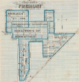
. The population was 2,138 at the 2010 census. Settled in 1834 as Willow Prairie, it became the Village of Brockville when it was plat
ted in 1837. In 1848, it was renamed to honor John C. Frémont
, "the Great Pathfinder", in part because there was already a Brockville in Indiana.
In 1914, the first hospital in Steuben County was opened in Fremont by Dr. Wade.
and the Indiana Toll Road
(Interstate 80
/90
) on State Road 120.
According to the United States Census Bureau
, the town has a total area of 2.2 square miles (5.7 km²), of which, 2.2 square miles (5.7 km²) of it is land and 0.45% is water.
As an oddity, someone traveling due east from Fremont crosses into Michigan—not into Ohio. This is due to the early 19th century Ohio-Michigan boundary dispute over Toledo (qv. Toledo War
for details).
of 2000, there were 1,696 people, 640 households, and 455 families residing in the town. The population density
was 761.9 people per square mile (293.6/km²). There were 679 housing units at an average density of 305.0 per square mile (117.6/km²). The racial makeup of the town was 98.11% White, 0.18% African American, 0.29% Native American, 0.06% Asian, 0.47% from other races
, and 0.88% from two or more races. Hispanic or Latino of any race were 1.95% of the population.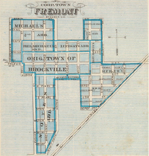 There were 640 households out of which 43.4% had children under the age of 18 living with them, 50.8% were married couples
living together, 15.2% had a female householder with no husband present, and 28.9% were non-families. 26.1% of all households were made up of individuals and 11.7% had someone living alone who was 65 years of age or older. The average household size was 2.65 and the average family size was 3.18.
In the town the population was spread out with 33.1% under the age of 18, 8.1% from 18 to 24, 29.7% from 25 to 44, 18.3% from 45 to 64, and 10.8% who were 65 years of age or older. The median age was 32 years. For every 100 females there were 83.0 males. For every 100 females age 18 and over, there were 80.4 males.
The median income for a household in the town was $38,462, and the median income for a family was $42,446. Males had a median income of $31,333 versus $22,260 for females. The per capita income
for the town was $16,067. About 5.7% of families and 7.3% of the population were below the poverty line, including 6.6% of those under age 18 and 10.1% of those age 65 or over.
sites in or near Fremont:
Fremont and the surrounding area enjoys several facilities and activities throughout the year:
Fremont Township, Steuben County, Indiana
Fremont Township is one of twelve townships in Steuben County, Indiana, USA. As of the 2000 census, its population was 2,467.-Geography:Fremont Township covers an area of ; of this, or 0.88 percent is water...
, Steuben County
Steuben County, Indiana
Steuben County is a county located in the northeast corner of the U.S. state of Indiana. As of 2010, the population was 34,185. The county seat is Angola...
, Indiana
Indiana
Indiana is a US state, admitted to the United States as the 19th on December 11, 1816. It is located in the Midwestern United States and Great Lakes Region. With 6,483,802 residents, the state is ranked 15th in population and 16th in population density. Indiana is ranked 38th in land area and is...
, United States
United States
The United States of America is a federal constitutional republic comprising fifty states and a federal district...
. The population was 2,138 at the 2010 census. Settled in 1834 as Willow Prairie, it became the Village of Brockville when it was plat
Plat
A plat in the U.S. is a map, drawn to scale, showing the divisions of a piece of land. Other English-speaking countries generally call such documents a cadastral map or plan....
ted in 1837. In 1848, it was renamed to honor John C. Frémont
John C. Frémont
John Charles Frémont , was an American military officer, explorer, and the first candidate of the anti-slavery Republican Party for the office of President of the United States. During the 1840s, that era's penny press accorded Frémont the sobriquet The Pathfinder...
, "the Great Pathfinder", in part because there was already a Brockville in Indiana.
In 1914, the first hospital in Steuben County was opened in Fremont by Dr. Wade.
Geography
Fremont is located at 41°43′52"N 84°55′57"W, four miles east of the interchange between Interstate 69Interstate 69
Interstate 69 is an Interstate Highway in the United States. It exists in two parts: a completed highway from Indianapolis, Indiana, northeast to the Canadian border in Port Huron, Michigan, and a mostly proposed extension southwest to the Mexican border in Texas...
and the Indiana Toll Road
Indiana Toll Road
The Indiana Toll Road, officially the Indiana East–West Toll Road, is a toll road that runs for east–west across northern Indiana from the Illinois state line to the Ohio state line...
(Interstate 80
Interstate 80
Interstate 80 is the second-longest Interstate Highway in the United States, following Interstate 90. It is a transcontinental artery running from downtown San Francisco, California to Teaneck, New Jersey in the New York City Metropolitan Area...
/90
Interstate 90
Interstate 90 is the longest Interstate Highway in the United States at . It is the northernmost coast-to-coast interstate, and parallels US 20 for the most part. Its western terminus is in Seattle, at Edgar Martinez Drive S. near Safeco Field and CenturyLink Field, and its eastern terminus is in...
) on State Road 120.
According to the United States Census Bureau
United States Census Bureau
The United States Census Bureau is the government agency that is responsible for the United States Census. It also gathers other national demographic and economic data...
, the town has a total area of 2.2 square miles (5.7 km²), of which, 2.2 square miles (5.7 km²) of it is land and 0.45% is water.
As an oddity, someone traveling due east from Fremont crosses into Michigan—not into Ohio. This is due to the early 19th century Ohio-Michigan boundary dispute over Toledo (qv. Toledo War
Toledo War
The Toledo War , also known as the Michigan-Ohio War, was the almost entirely bloodless boundary dispute between the U.S. state of Ohio and the adjoining territory of Michigan....
for details).
Demographics
As of the censusCensus
A census is the procedure of systematically acquiring and recording information about the members of a given population. It is a regularly occurring and official count of a particular population. The term is used mostly in connection with national population and housing censuses; other common...
of 2000, there were 1,696 people, 640 households, and 455 families residing in the town. The population density
Population density
Population density is a measurement of population per unit area or unit volume. It is frequently applied to living organisms, and particularly to humans...
was 761.9 people per square mile (293.6/km²). There were 679 housing units at an average density of 305.0 per square mile (117.6/km²). The racial makeup of the town was 98.11% White, 0.18% African American, 0.29% Native American, 0.06% Asian, 0.47% from other races
Race (United States Census)
Race and ethnicity in the United States Census, as defined by the Federal Office of Management and Budget and the United States Census Bureau, are self-identification data items in which residents choose the race or races with which they most closely identify, and indicate whether or not they are...
, and 0.88% from two or more races. Hispanic or Latino of any race were 1.95% of the population.
Marriage
Marriage is a social union or legal contract between people that creates kinship. It is an institution in which interpersonal relationships, usually intimate and sexual, are acknowledged in a variety of ways, depending on the culture or subculture in which it is found...
living together, 15.2% had a female householder with no husband present, and 28.9% were non-families. 26.1% of all households were made up of individuals and 11.7% had someone living alone who was 65 years of age or older. The average household size was 2.65 and the average family size was 3.18.
In the town the population was spread out with 33.1% under the age of 18, 8.1% from 18 to 24, 29.7% from 25 to 44, 18.3% from 45 to 64, and 10.8% who were 65 years of age or older. The median age was 32 years. For every 100 females there were 83.0 males. For every 100 females age 18 and over, there were 80.4 males.
The median income for a household in the town was $38,462, and the median income for a family was $42,446. Males had a median income of $31,333 versus $22,260 for females. The per capita income
Per capita income
Per capita income or income per person is a measure of mean income within an economic aggregate, such as a country or city. It is calculated by taking a measure of all sources of income in the aggregate and dividing it by the total population...
for the town was $16,067. About 5.7% of families and 7.3% of the population were below the poverty line, including 6.6% of those under age 18 and 10.1% of those age 65 or over.
Sites of interest
The following are National Register of Historic PlacesNational Register of Historic Places
The National Register of Historic Places is the United States government's official list of districts, sites, buildings, structures, and objects deemed worthy of preservation...
sites in or near Fremont:
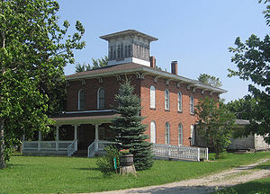
- The Enos Michael House, 200 E. Toledo St, built c. 1850.
- The William L. Lords House, Clear Lake Rd., built c. 1848.
- Pokagon State ParkPokagon State ParkPokagon State Park is located in northeastern Indiana close to the village of Fremont and north of Angola. It was named for the 19th-century Potawatomi chief, Leopold Pokagon, and his widely known son, Simon Pokagon, at Richard Lieber's suggestion...
, 4 miles west of Fremont, is known for recreational activities such as swimming in Lake James, campingCampingCamping is an outdoor recreational activity. The participants leave urban areas, their home region, or civilization and enjoy nature while spending one or several nights outdoors, usually at a campsite. Camping may involve the use of a tent, caravan, motorhome, cabin, a primitive structure, or no...
and tobogganing in the winter months. In addition to the park itself, the Combination Shelter (known locally as the CCCCivilian Conservation CorpsThe Civilian Conservation Corps was a public work relief program that operated from 1933 to 1942 in the United States for unemployed, unmarried men from relief families, ages 18–25. A part of the New Deal of President Franklin D...
Shelter) at the park is also on the Register.
Fremont and the surrounding area enjoys several facilities and activities throughout the year:
- Fremont hosts their annual Music Fest each July, which features a parade, live music, games and vendors. In 2011, the event will feature the Second Annual Mud Volleyball Tournament.
- City Park hosts a farmers' marketFarmers' marketA farmers' market consists of individual vendors—mostly farmers—who set up booths, tables or stands, outdoors or indoors, to sell produce, meat products, fruits and sometimes prepared foods and beverages...
on Saturday mornings during the summer months. - Pokagon State ParkPokagon State ParkPokagon State Park is located in northeastern Indiana close to the village of Fremont and north of Angola. It was named for the 19th-century Potawatomi chief, Leopold Pokagon, and his widely known son, Simon Pokagon, at Richard Lieber's suggestion...
sponsors a deer hunt in the autumn of most years to help control the population. - Vistula Park is home to Fremont's little league baseball and softball diamonds. It also has basketball hoops, a pavilion and over a mile of paved walking trails in its woods.
- On Lake George, a former hotel and now a restaurant, the Lake George Retreat, serves a variety of cuisine in a historic setting.
- The Fremont Public Library, with over 51,000 titles, opened in 2003 and is one of the premier libraries in the region.
Schools
Fremont Community Schools oversees three schools in its district: Fremont High School, Fremont Middle School and Fremont Elementary School. Enrollment in each building ranges from between 350 and 400 students annually. Several extracurricular athletic programs are available at the middle and high school levels, including football, basketball, volleyball, wrestling, cross country, track and golf. FHS also fields teams for tennis, baseball and softball.Manufacturing
Fremont is home to several manufacturing facilities, including Cold Heading, Swager Communications, New Horizons Baking Company and Dexter Axle. Among others is Cardinal IG, which came to Fremont in March of 1998. Cardinal IG, manufacturers of glass products, have been recognized as a green company, recycling virtually all of the plastic, paper and cardboard used in manufacturing processes.Downtown Revitalization
In December 2010, Fremont was awarded $500,000 from the State of Indiana for its downtown revitalization project. According to the Town of Fremont website, the plan includes improvements for pedestrian traffic, new street lighting and signage options, and reverse angle parking along Toledo Street for two blocks between Tolford and Pleasant Streets. Construction is set to begin in September 2011 and finish roughly 90 days later.See also
- "Life's Better Here" feature on Fremont, Indiana on June 8, 2011
- Photo of Fremont High School
- Map of Vistula Park