
Interstate 90 in Washington
Encyclopedia
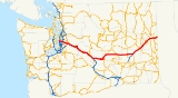
Interstate 90 a transcontinental Interstate Highway
from Seattle, Washington, to Boston
, Massachusetts
, crosses the state of Washington before crossing the Idaho
state line between Spokane
and Post Falls
. It serves the cities of Seattle, Bellevue
, Issaquah
, Ellensburg
, Moses Lake
, Ritzville
, and Spokane.
It is the only Interstate Highway to cross the state east to west, but there are two U.S. Routes
that also do the same, U.S. Route 2
and U.S. Route 12
, along with a few state highways
. I-90 is also the only highway in Washington to connect the two largest cities in the state (Seattle and Spokane). The road is the third busiest in the state, behind I-5
at 240,000 and I-405
at 201,000. An estimated 148,000 motorists use the road daily.
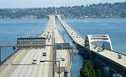
I-90 incorporates two of the longest floating bridge
s in the world, the Lacey V. Murrow Memorial Bridge
and the Homer M. Hadley Memorial Bridge
, which cross Lake Washington
from Seattle to Mercer Island, Washington
. They are the second- and fifth-longest such bridges, respectively.
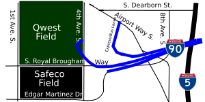
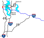 Interstate 90 starts at the merging of onramps from 4th Avenue S. and Edgar Martínez Drive S. (formerly S. Atlantic Street) south of Downtown Seattle. The recently rebuilt freeway joins the I-90 Express Lanes and goes east to an interchange with I-5
. After leaving the interchange, the highway travels through the Central Area and into the Mount Baker Tunnel
, a tunnel on the National Register of Historic Places
that carries I-90 and its express lanes under the Mount Baker neighborhood
. After emerging from the eastern portal of the tunnel, I-90 splits and the eastbound lanes go on the Lacey V. Murrow Memorial Bridge
and the westbound lanes exit off the Homer M. Hadley Memorial Bridge
, which is shared with the I-90 express lanes, both over Lake Washington
.
After crossing Lake Washington, I-90 enters Mercer Island and goes under the Mercer Island Lid
at West Mercer Way and emerges at 76th Avenue SE before leaving Mercer Island to cross over Lake Washington again on the shorter East Channel Bridge
into Eastside
. Once in Eastside, the highway enters Bellevue
and travels east to Bellevue Way, where the express lanes merge with I-90 or keep going to exit off to I-405
.
After leaving a stack interchange
with I-405 north of the Factoria Mall, the freeway passes Bellevue College, Lake Sammamish
, and Lake Sammamish State Park
before entering Issaquah
and intersecting SR 900.
After passing by downtown Issaquah, the highway goes along the northern boundary of the Tiger Mountain State Forest and passes Preston, where the speed limit raises from 60 MPH to 70 MPH, before intersecting SR 18 in Upper Preston. From Upper Preston, I-90 passes Echo Lake
and Snoqualmie
before entering North Bend
, where SR 202 begins after an interchange with the highway.
 Interstate 90 has a 7.45 miles (11.99 km) long reversible
express lane that go across Lake Washington
from Seattle to Bellevue
. The express lane starts at two different locations, one at the southern terminus of the Downtown Seattle Transit Tunnel and the other at a signalled intersection at 5th Avenue S., S. Dearborn Street, and Airport Way S. The lanes turn east and travel in a separated right-of-way before traveling towards the middle of I-90 east of the interchange with I-5. This section is bi-directional, containing two lanes separated by a barrier, and allows buses to use the lanes in both directions at all times. From there, the lanes travel through the Mount Baker Tunnel
and onto the Homer M. Hadley Memorial Bridge
, sharing the bridge with the westbound lanes. From there, the lanes travel through Mercer Island and ends at its terminus with the I-90 interchange with Bellevue Way, with ramps connecting to mainline I-90 and I-405
.
Segments of the express lanes between the western terminus to I-90 ramps and Island Crest Way and the eastern terminus are reserved for HOV only. The westbound traffic uses the express lanes from 1 am to 12:30 pm (MondayFriday) The eastbound traffic uses the express lanes from 2 pm to 12 midnight (MondayFriday) and all day from Saturday to Sunday. The express lanes are closed every other Tuesday from 10 am to 1:30 pm.
 Forty-two miles east of Bellevue, at milepost 53, I-90 traverses the Cascade Mountain
s via Snoqualmie Pass
, elevation 3022 feet (921.1 m), the only interstate crossing and second-lowest east–west crossing in Washington State. I-90 then goes out towards the Columbia Plateau
, passing through the cities of Cle Elum
and Ellensburg
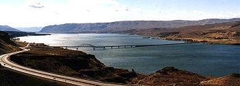
. It crosses the Columbia River
on the Vantage Bridge
. After passing in to Grant County, North Frontage Road and South Frontage Road parallel I-90 through Grant County. The frontage roads intersect each exit off I-90 (Exits 143 to 174 and Exits 179 to 184. In Moses Lake
at Exit 174, the frontage roads end. The freeway passes through Moses Lake
. The frontage roads begin again at Exit 179 in Moses Lake
and end at the Adams County line.
 At Ritzville, I-90 forms a concurrency
with US 395 towards Spokane
, where US 2 also forms a concurrency and both US 395 and US 2 branch off from I-90 at Downtown Spokane. I-90 continues to head east through the suburbs of Spokane and into Idaho
.
As part of the state's first connected state highway system, the Washington State Legislature
designated the Sunset Highway between Seattle and Idaho
in 1913. Later in 1915, the Legislature also designated the North Central Highway between Ellensburg
and Davenport
. The State Highway Board selected two routes that would partially connect the main cities of Western Washington
to Eastern Washington
and Idaho
. In 1923, by which time the entire road had been improved and a new connection had filled in a small gap, the Sunset Highway
became State Road 2 (Primary State Highway 2 after 1937), but retained its name. The North Central Highway became State Road 7 (Primary State Highway 7 after 1937), but retained its name. Another highway, named Primary State Highway 18 between George
and Ritzville
. By that time, most of the route of Interstate 90 became US 10
, which was established in 1926. Until 1940, the route headed south from Seattle to Renton, then east to Issaquah, in order to travel around Lake Washington
.
Interstate 90 crosses Lake Washington
between Seattle and Bellevue
on a pair of floating bridges that are two of the world's longest floating bridges. The westbound lanes travel on the Homer M. Hadley Memorial Bridge
, the fifth longest floating bridge, and the eastbound lanes travel on the Lacey V. Murrow Memorial Bridge
, the second longest floating bridge. The Lacey V. Murrow Memorial Bridge, originally called the Lake Washington Floating Bridge, opened on July 2, 1940. The bridge collapsed during construction on November 25, 1990. It was later rebuilt and the new bridge opened later in 1993. The second bridge, the Homer M. Hadley Memorial Bridge, opened on June 4, 1989.
 Later in 1956, President
Dwight D. Eisenhower
signed the Federal-Aid Highway Act of 1956 which started the construction of Interstate Highways
. By 1969, US 10 was removed from the system entirely. During the construction of the freeway between Seattle and Bellevue
, lawsuits were filed on May 28, 1970 and stopped construction of Interstate 90 until the early 1990s. Legally, the Washington section of I-90 is defined at Washington Revised Code § 47.17.140. In 1980, I-90 from Seattle to Thorp
was designated the Mountains to Sound Greenway to protect its outstanding scenic and cultural resources.
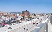
Before 2003, Interstate 90 used to end at a signalled intersection with 4th Avenue S. However, increasing traffic from Downtown Seattle, Colman Dock, Safeco Field
, and Qwest Field
forced city, county, and state officials to look for improvements to the area. The first stage of the improvements, the SR 519 South Seattle Intermodal Access Project, included the construction of a new on-ramp to Interstate 90 via a new interchange with 4th Avenue S. and Edgar Martínez Drive S. (formerly S. Atlantic Street). Other projects are currently ongoing and have been completed in the recent years on I-90.
Interstate Highway System
The Dwight D. Eisenhower National System of Interstate and Defense Highways, , is a network of limited-access roads including freeways, highways, and expressways forming part of the National Highway System of the United States of America...
from Seattle, Washington, to Boston
Boston
Boston is the capital of and largest city in Massachusetts, and is one of the oldest cities in the United States. The largest city in New England, Boston is regarded as the unofficial "Capital of New England" for its economic and cultural impact on the entire New England region. The city proper had...
, Massachusetts
Massachusetts
The Commonwealth of Massachusetts is a state in the New England region of the northeastern United States of America. It is bordered by Rhode Island and Connecticut to the south, New York to the west, and Vermont and New Hampshire to the north; at its east lies the Atlantic Ocean. As of the 2010...
, crosses the state of Washington before crossing the Idaho
Idaho
Idaho is a state in the Rocky Mountain area of the United States. The state's largest city and capital is Boise. Residents are called "Idahoans". Idaho was admitted to the Union on July 3, 1890, as the 43rd state....
state line between Spokane
Spokane, Washington
Spokane is a city located in the Northwestern United States in the state of Washington. It is the largest city of Spokane County of which it is also the county seat, and the metropolitan center of the Inland Northwest region...
and Post Falls
Post Falls, Idaho
Post Falls is a city in Kootenai County, Idaho, United States near the Idaho state line between Spokane, Washington, and Coeur d'Alene, Idaho. The population was 17,247 at the 2000 census, and grew to 27,574 people by the 2010 census, making it Idaho's tenth largest city.-History:Post Falls is...
. It serves the cities of Seattle, Bellevue
Bellevue, Washington
Bellevue is a city in the Eastside region of King County, Washington, United States, across Lake Washington from Seattle. Long known as a suburb or satellite city of Seattle, it is now categorized as an edge city or a boomburb. The population was 122,363 at the 2010 census.Downtown Bellevue is...
, Issaquah
Issaquah, Washington
Issaquah is a city in King County, Washington, United States. The population was 30,434 at the 2010 census.Based on per capita income, Issaquah ranks 25th of 522 areas in the State of Washington to be ranked....
, Ellensburg
Ellensburg, Washington
Ellensburg is a city in, and the county seat of, Kittitas County, Washington, United States. The population was 18,174 at the 2010 census. The population was 18,250 at 2011 Estimate from Office of Financial Management. Ellensburg is located just east of the Cascade Range on I-90 and is known as the...
, Moses Lake
Moses Lake, Washington
Moses Lake is a city in Grant County, Washington, United States. The population was 20,366 as of the 2010 census. Moses Lake is the largest city in Grant County.-Background:...
, Ritzville
Ritzville, Washington
Ritzville is a city in Adams County, Washington, United States. The population was 1,673 at the 2010 census. It is the county seat of Adams County.-History:...
, and Spokane.
It is the only Interstate Highway to cross the state east to west, but there are two U.S. Routes
United States Numbered Highways
The system of United States Numbered Highways is an integrated system of roads and highways in the United States numbered within a nationwide grid...
that also do the same, U.S. Route 2
U.S. Route 2 in Washington
U.S. Route 2 is a part of the United States Numbered Highway System that has a western segment that runs from Everett, Washington, to the Upper Peninsula of the US state of Michigan. In Washington, it is a state highway that begins at in Downtown Everett. The of US 2 that lie within...
and U.S. Route 12
U.S. Route 12 in Washington
U.S. Route 12 is a major east-west U.S. Highway, running from Aberdeen, Washington, to Detroit, Michigan. It spans across the state of Washington, and is the only numbered highway to span the entire state from west to east, starting near the Pacific Ocean, and crossing the Idaho state line near...
, along with a few state highways
State highways in Washington
In the U.S. state of Washington, the Washington State Department of Transportation maintains a network of over 7000 miles of state highways, including all Interstate and U.S. Highways that pass through the state. The system comprises 8.5% of the state's public road mileage, but carries over half...
. I-90 is also the only highway in Washington to connect the two largest cities in the state (Seattle and Spokane). The road is the third busiest in the state, behind I-5
Interstate 5 in Washington
Interstate 5 in Washington is a highway in the U.S. state of Washington that extends from its border with Oregon to its border with Canada...
at 240,000 and I-405
Interstate 405 (Washington)
Interstate 405 in Washington is a stretch of freeway that bypasses Seattle east of Lake Washington. The northern terminus is in Lynnwood and the southern terminus is in Tukwila...
at 201,000. An estimated 148,000 motorists use the road daily.
I-90 incorporates two of the longest floating bridge
Pontoon bridge
A pontoon bridge or floating bridge is a bridge that floats on water and in which barge- or boat-like pontoons support the bridge deck and its dynamic loads. While pontoon bridges are usually temporary structures, some are used for long periods of time...
s in the world, the Lacey V. Murrow Memorial Bridge
Lacey V. Murrow Memorial Bridge
The Lacey V. Murrow Memorial Bridge is a floating bridge that carries the eastbound lanes of Interstate 90 across Lake Washington from Seattle to Mercer Island, Washington. It is the second longest floating bridge on Earth at , whereas the longest is the Evergreen Point Floating Bridge just a few...
and the Homer M. Hadley Memorial Bridge
Homer M. Hadley Memorial Bridge
The Third Lake Washington Bridge, officially the Homer M. Hadley Memorial Bridge, is the fifth-longest floating bridge in the world, at 5,811 feet...
, which cross Lake Washington
Lake Washington
Lake Washington is a large freshwater lake adjacent to the city of Seattle. It is the largest lake in King County and the second largest in the state of Washington, after Lake Chelan. It is bordered by the cities of Seattle on the west, Bellevue and Kirkland on the east, Renton on the south and...
from Seattle to Mercer Island, Washington
Mercer Island, Washington
Mercer Island is a city in King County, Washington, United States and the name of the island in Lake Washington on which the city sits. The population was 22,699 at the 2010 census....
. They are the second- and fifth-longest such bridges, respectively.
Seattle to Snoqualmie Pass
Interstate 5 in Washington
Interstate 5 in Washington is a highway in the U.S. state of Washington that extends from its border with Oregon to its border with Canada...
. After leaving the interchange, the highway travels through the Central Area and into the Mount Baker Tunnel
Mount Baker Tunnel
The Mount Baker Tunnel or Mount Baker Ridge Tunnel carries Interstate 90 under the Mount Baker neighborhood of Seattle, Washington. It is actually a group of four tunnels that carry eight lanes of freeway traffic, plus a separate tunnel for bicycles and pedestrians. The two originals are twin...
, a tunnel on the National Register of Historic Places
National Register of Historic Places
The National Register of Historic Places is the United States government's official list of districts, sites, buildings, structures, and objects deemed worthy of preservation...
that carries I-90 and its express lanes under the Mount Baker neighborhood
Mount Baker, Seattle, Washington
Mount Baker is a neighborhood in southeast Seattle. The neighborhood's name comes from the view of Mount Baker in Whatcom County, that is seen by looking north over Lake Washington. It is bounded by Lake Washington to the east, Interstate 90 and then Leschi to the north, Rainier Valley to the west,...
. After emerging from the eastern portal of the tunnel, I-90 splits and the eastbound lanes go on the Lacey V. Murrow Memorial Bridge
Lacey V. Murrow Memorial Bridge
The Lacey V. Murrow Memorial Bridge is a floating bridge that carries the eastbound lanes of Interstate 90 across Lake Washington from Seattle to Mercer Island, Washington. It is the second longest floating bridge on Earth at , whereas the longest is the Evergreen Point Floating Bridge just a few...
and the westbound lanes exit off the Homer M. Hadley Memorial Bridge
Homer M. Hadley Memorial Bridge
The Third Lake Washington Bridge, officially the Homer M. Hadley Memorial Bridge, is the fifth-longest floating bridge in the world, at 5,811 feet...
, which is shared with the I-90 express lanes, both over Lake Washington
Lake Washington
Lake Washington is a large freshwater lake adjacent to the city of Seattle. It is the largest lake in King County and the second largest in the state of Washington, after Lake Chelan. It is bordered by the cities of Seattle on the west, Bellevue and Kirkland on the east, Renton on the south and...
.
After crossing Lake Washington, I-90 enters Mercer Island and goes under the Mercer Island Lid
Mercer Island Lid
The Mercer Island Lid, officially the Luther Burbank Lid, is a half-mile concrete and steel structure that covers a section of Interstate 90 from just west of W. Mercer Way to 76th Avenue S.E. The Lid is home to a landscaped park, Park on the Lid, in Mercer Island, Washington, USA The Lid is also,...
at West Mercer Way and emerges at 76th Avenue SE before leaving Mercer Island to cross over Lake Washington again on the shorter East Channel Bridge
East Channel Bridge
The East Channel Bridge is a bridge carrying Interstate 90 from Mercer Island, Washington, to Bellevue, Washington, over the East Channel of Lake Washington, which separates Mercer Island from the rest of the Eastside....
into Eastside
Eastside (King County, Washington)
File:Seattle-lakewashington-lakesammamish.PNG|250px|right|The Eastside is to the right of Seattle.# rough city boundariespoly 137 256 148 256 158 194 172 179 172 237 212 266 133 266Renton...
. Once in Eastside, the highway enters Bellevue
Bellevue, Washington
Bellevue is a city in the Eastside region of King County, Washington, United States, across Lake Washington from Seattle. Long known as a suburb or satellite city of Seattle, it is now categorized as an edge city or a boomburb. The population was 122,363 at the 2010 census.Downtown Bellevue is...
and travels east to Bellevue Way, where the express lanes merge with I-90 or keep going to exit off to I-405
Interstate 405 (Washington)
Interstate 405 in Washington is a stretch of freeway that bypasses Seattle east of Lake Washington. The northern terminus is in Lynnwood and the southern terminus is in Tukwila...
.
After leaving a stack interchange
Stack interchange
A stack interchange is a free-flowing grade separated junction between two roads.In countries where one drives on the right, left turns are handled by semi-directional flyover/under ramps...
with I-405 north of the Factoria Mall, the freeway passes Bellevue College, Lake Sammamish
Lake Sammamish
Lake Sammamish is a freshwater lake east of Seattle in King County, Washington, United States. The lake is long and wide, with a maximum depth of and a surface area of . It lies east of Lake Washington and west of the Sammamish Plateau, and stretches from Issaquah in the south to Redmond in...
, and Lake Sammamish State Park
Lake Sammamish State Park
Lake Sammamish State Park is a park at the south end of Lake Sammamish, in King County, Washington, United States. The park is administered by the Washington State Park System. The park covers an area of and has of waterfront and is known for its boating and watersport activities, such as...
before entering Issaquah
Issaquah, Washington
Issaquah is a city in King County, Washington, United States. The population was 30,434 at the 2010 census.Based on per capita income, Issaquah ranks 25th of 522 areas in the State of Washington to be ranked....
and intersecting SR 900.
After passing by downtown Issaquah, the highway goes along the northern boundary of the Tiger Mountain State Forest and passes Preston, where the speed limit raises from 60 MPH to 70 MPH, before intersecting SR 18 in Upper Preston. From Upper Preston, I-90 passes Echo Lake
Echo Lake, Washington
Echo Lake is a census-designated place in Snohomish County, Washington, United States. The population was 849 at the 2000 census.-Geography:Echo Lake is located at ....
and Snoqualmie
Snoqualmie, Washington
Snoqualmie is a city next to Snoqualmie Falls in King County, Washington. The city is home to the Northwest Railway Museum. The population was of 10,670 at the 2010 census...
before entering North Bend
North Bend, Washington
North Bend is a city in King County, Washington, United States. The town was made famous by David Lynch's television series Twin Peaks Since the Weyerhaeuser sawmill closed, North Bend has become an upscale bedroom community for the Eastside of Seattle, Washington, with property values more than...
, where SR 202 begins after an interchange with the highway.
Seattle-Bellevue Express Lanes
Reversible lane
A reversible lane , called a counterflow lane or contraflow lane in transport engineering nomenclature, is a lane in which traffic may travel in either direction, depending on certain conditions...
express lane that go across Lake Washington
Lake Washington
Lake Washington is a large freshwater lake adjacent to the city of Seattle. It is the largest lake in King County and the second largest in the state of Washington, after Lake Chelan. It is bordered by the cities of Seattle on the west, Bellevue and Kirkland on the east, Renton on the south and...
from Seattle to Bellevue
Bellevue, Washington
Bellevue is a city in the Eastside region of King County, Washington, United States, across Lake Washington from Seattle. Long known as a suburb or satellite city of Seattle, it is now categorized as an edge city or a boomburb. The population was 122,363 at the 2010 census.Downtown Bellevue is...
. The express lane starts at two different locations, one at the southern terminus of the Downtown Seattle Transit Tunnel and the other at a signalled intersection at 5th Avenue S., S. Dearborn Street, and Airport Way S. The lanes turn east and travel in a separated right-of-way before traveling towards the middle of I-90 east of the interchange with I-5. This section is bi-directional, containing two lanes separated by a barrier, and allows buses to use the lanes in both directions at all times. From there, the lanes travel through the Mount Baker Tunnel
Mount Baker Tunnel
The Mount Baker Tunnel or Mount Baker Ridge Tunnel carries Interstate 90 under the Mount Baker neighborhood of Seattle, Washington. It is actually a group of four tunnels that carry eight lanes of freeway traffic, plus a separate tunnel for bicycles and pedestrians. The two originals are twin...
and onto the Homer M. Hadley Memorial Bridge
Homer M. Hadley Memorial Bridge
The Third Lake Washington Bridge, officially the Homer M. Hadley Memorial Bridge, is the fifth-longest floating bridge in the world, at 5,811 feet...
, sharing the bridge with the westbound lanes. From there, the lanes travel through Mercer Island and ends at its terminus with the I-90 interchange with Bellevue Way, with ramps connecting to mainline I-90 and I-405
Interstate 405 (Washington)
Interstate 405 in Washington is a stretch of freeway that bypasses Seattle east of Lake Washington. The northern terminus is in Lynnwood and the southern terminus is in Tukwila...
.
Segments of the express lanes between the western terminus to I-90 ramps and Island Crest Way and the eastern terminus are reserved for HOV only. The westbound traffic uses the express lanes from 1 am to 12:30 pm (MondayFriday) The eastbound traffic uses the express lanes from 2 pm to 12 midnight (MondayFriday) and all day from Saturday to Sunday. The express lanes are closed every other Tuesday from 10 am to 1:30 pm.
Snoqualmie Pass to Ritzville
Cascade Mountain
Cascade Mountain can refer to:* Cascade Mountain in Alberta, Canada.* Cascade Mountain in New York, United States.When pluralized, Cascade Mountains generally refers either to the Cascade Range that runs north-south along the west coast of North America from British Columbia to Mount Shasta in...
s via Snoqualmie Pass
Snoqualmie Pass
Snoqualmie Pass is a mountain pass that carries Interstate 90 through the Cascade Range in the U.S. State of Washington. The elevation of the pass summit is , and is on the county line between Kittitas County and King County...
, elevation 3022 feet (921.1 m), the only interstate crossing and second-lowest east–west crossing in Washington State. I-90 then goes out towards the Columbia Plateau
Columbia Plateau
The Columbia Plateau is a geologic and geographic region that lies across parts of the U.S. states of Washington, Oregon, and Idaho. It is a wide flood basalt plateau between the Cascade Range and the Rocky Mountains, cut through by the Columbia River...
, passing through the cities of Cle Elum
Cle Elum, Washington
Cle Elum is a city in Kittitas County, Washington, United States. The population was 1,872 at the 2010 census. Only an hour and a half's drive from Seattle, Cle Elum is a popular area for camping and outdoor activities.-Early years and industries:...
and Ellensburg
Ellensburg, Washington
Ellensburg is a city in, and the county seat of, Kittitas County, Washington, United States. The population was 18,174 at the 2010 census. The population was 18,250 at 2011 Estimate from Office of Financial Management. Ellensburg is located just east of the Cascade Range on I-90 and is known as the...
. It crosses the Columbia River
Columbia River
The Columbia River is the largest river in the Pacific Northwest region of North America. The river rises in the Rocky Mountains of British Columbia, Canada, flows northwest and then south into the U.S. state of Washington, then turns west to form most of the border between Washington and the state...
on the Vantage Bridge
Vantage Bridge
The Vantage Bridge is a bridge in the U.S. state of Washington. It carries Interstate 90 across the Columbia River, near Vantage and George, Washington. This section of the river is named Wanapum Lake; it is the reservoir formed by Wanapum Dam...
. After passing in to Grant County, North Frontage Road and South Frontage Road parallel I-90 through Grant County. The frontage roads intersect each exit off I-90 (Exits 143 to 174 and Exits 179 to 184. In Moses Lake
Moses Lake, Washington
Moses Lake is a city in Grant County, Washington, United States. The population was 20,366 as of the 2010 census. Moses Lake is the largest city in Grant County.-Background:...
at Exit 174, the frontage roads end. The freeway passes through Moses Lake
Moses Lake, Washington
Moses Lake is a city in Grant County, Washington, United States. The population was 20,366 as of the 2010 census. Moses Lake is the largest city in Grant County.-Background:...
. The frontage roads begin again at Exit 179 in Moses Lake
Moses Lake, Washington
Moses Lake is a city in Grant County, Washington, United States. The population was 20,366 as of the 2010 census. Moses Lake is the largest city in Grant County.-Background:...
and end at the Adams County line.
Ritzville to Idaho
Concurrency (road)
A concurrency, overlap, or coincidence in a road network is an instance of one physical road bearing two or more different highway, motorway, or other route numbers...
with US 395 towards Spokane
Spokane, Washington
Spokane is a city located in the Northwestern United States in the state of Washington. It is the largest city of Spokane County of which it is also the county seat, and the metropolitan center of the Inland Northwest region...
, where US 2 also forms a concurrency and both US 395 and US 2 branch off from I-90 at Downtown Spokane. I-90 continues to head east through the suburbs of Spokane and into Idaho
Interstate 90 in Idaho
In the U.S. state of Idaho, Interstate 90 has a small routing in the panhandle, just under 74 miles . Traveling east from Spokane, Washington, I-90 passes through Post Falls and Coeur d'Alene, over Fourth of July Summit, and through the Silver Valley before entering Montana at Lookout Pass.I-90 is...
.
History
   |
| The shields of Primary State Highways 2, 7, and 18. |
As part of the state's first connected state highway system, the Washington State Legislature
Washington State Legislature
The Washington State Legislature is the state legislature of the U.S. state of Washington. It is a bipartisan, bicameral body, composed of the lower Washington House of Representatives, composed of 98 Representatives, and the upper Washington State Senate, with 49 Senators.The State Legislature...
designated the Sunset Highway between Seattle and Idaho
Idaho
Idaho is a state in the Rocky Mountain area of the United States. The state's largest city and capital is Boise. Residents are called "Idahoans". Idaho was admitted to the Union on July 3, 1890, as the 43rd state....
in 1913. Later in 1915, the Legislature also designated the North Central Highway between Ellensburg
Ellensburg, Washington
Ellensburg is a city in, and the county seat of, Kittitas County, Washington, United States. The population was 18,174 at the 2010 census. The population was 18,250 at 2011 Estimate from Office of Financial Management. Ellensburg is located just east of the Cascade Range on I-90 and is known as the...
and Davenport
Davenport, Washington
Davenport is a city in Lincoln County, Washington, United States. The population was 1,734 at the 2010 census. It is the county seat of Lincoln County.-History:Davenport was first settled in 1880, and was named in 1882 for resident J.C. Davenport...
. The State Highway Board selected two routes that would partially connect the main cities of Western Washington
Western Washington
Western Washington is a region of the United States defined as that part of Washington west of the Cascade Mountains.It is known as being far wetter in climate than the eastern portion of the state, which...
to Eastern Washington
Eastern Washington
Eastern Washington is the portion of the U.S. state of Washington east of the Cascade Range. The region contains the city of Spokane , the Tri-Cities, the Columbia River and the Grand Coulee Dam, the Hanford Nuclear Reservation and the fertile farmlands of the Yakima Valley and the...
and Idaho
Idaho
Idaho is a state in the Rocky Mountain area of the United States. The state's largest city and capital is Boise. Residents are called "Idahoans". Idaho was admitted to the Union on July 3, 1890, as the 43rd state....
. In 1923, by which time the entire road had been improved and a new connection had filled in a small gap, the Sunset Highway
Sunset Highway
Sunset Highway may refer to:*Sunset Highway , the western most portion of U.S. Highway 26 in Oregon*Sunset Highway , a.k.a Primary State Highway 2...
became State Road 2 (Primary State Highway 2 after 1937), but retained its name. The North Central Highway became State Road 7 (Primary State Highway 7 after 1937), but retained its name. Another highway, named Primary State Highway 18 between George
George, Washington
George is a city in Grant County, Washington, United States. The population was 528 at the 2000 census. Its name is a play on the name of George Washington.The city is known for being near the Gorge Amphitheatre, sometimes being called, "The Gorge at George"....
and Ritzville
Ritzville, Washington
Ritzville is a city in Adams County, Washington, United States. The population was 1,673 at the 2010 census. It is the county seat of Adams County.-History:...
. By that time, most of the route of Interstate 90 became US 10
U.S. Route 10
U.S. Route 10 is an east–west United States highway formed in 1926. Though it never became the cross-country highway suggested by the "0" as the last digit of its route number, U.S...
, which was established in 1926. Until 1940, the route headed south from Seattle to Renton, then east to Issaquah, in order to travel around Lake Washington
Lake Washington
Lake Washington is a large freshwater lake adjacent to the city of Seattle. It is the largest lake in King County and the second largest in the state of Washington, after Lake Chelan. It is bordered by the cities of Seattle on the west, Bellevue and Kirkland on the east, Renton on the south and...
.
Interstate 90 crosses Lake Washington
Lake Washington
Lake Washington is a large freshwater lake adjacent to the city of Seattle. It is the largest lake in King County and the second largest in the state of Washington, after Lake Chelan. It is bordered by the cities of Seattle on the west, Bellevue and Kirkland on the east, Renton on the south and...
between Seattle and Bellevue
Bellevue, Washington
Bellevue is a city in the Eastside region of King County, Washington, United States, across Lake Washington from Seattle. Long known as a suburb or satellite city of Seattle, it is now categorized as an edge city or a boomburb. The population was 122,363 at the 2010 census.Downtown Bellevue is...
on a pair of floating bridges that are two of the world's longest floating bridges. The westbound lanes travel on the Homer M. Hadley Memorial Bridge
Homer M. Hadley Memorial Bridge
The Third Lake Washington Bridge, officially the Homer M. Hadley Memorial Bridge, is the fifth-longest floating bridge in the world, at 5,811 feet...
, the fifth longest floating bridge, and the eastbound lanes travel on the Lacey V. Murrow Memorial Bridge
Lacey V. Murrow Memorial Bridge
The Lacey V. Murrow Memorial Bridge is a floating bridge that carries the eastbound lanes of Interstate 90 across Lake Washington from Seattle to Mercer Island, Washington. It is the second longest floating bridge on Earth at , whereas the longest is the Evergreen Point Floating Bridge just a few...
, the second longest floating bridge. The Lacey V. Murrow Memorial Bridge, originally called the Lake Washington Floating Bridge, opened on July 2, 1940. The bridge collapsed during construction on November 25, 1990. It was later rebuilt and the new bridge opened later in 1993. The second bridge, the Homer M. Hadley Memorial Bridge, opened on June 4, 1989.
President of the United States
The President of the United States of America is the head of state and head of government of the United States. The president leads the executive branch of the federal government and is the commander-in-chief of the United States Armed Forces....
Dwight D. Eisenhower
Dwight D. Eisenhower
Dwight David "Ike" Eisenhower was the 34th President of the United States, from 1953 until 1961. He was a five-star general in the United States Army...
signed the Federal-Aid Highway Act of 1956 which started the construction of Interstate Highways
Interstate Highway System
The Dwight D. Eisenhower National System of Interstate and Defense Highways, , is a network of limited-access roads including freeways, highways, and expressways forming part of the National Highway System of the United States of America...
. By 1969, US 10 was removed from the system entirely. During the construction of the freeway between Seattle and Bellevue
Bellevue, Washington
Bellevue is a city in the Eastside region of King County, Washington, United States, across Lake Washington from Seattle. Long known as a suburb or satellite city of Seattle, it is now categorized as an edge city or a boomburb. The population was 122,363 at the 2010 census.Downtown Bellevue is...
, lawsuits were filed on May 28, 1970 and stopped construction of Interstate 90 until the early 1990s. Legally, the Washington section of I-90 is defined at Washington Revised Code § 47.17.140. In 1980, I-90 from Seattle to Thorp
Thorp, Washington
Thorp is an unincorporated town and census-designated place in Kittitas County, Washington, United States. The population was 240 at the 2010 census...
was designated the Mountains to Sound Greenway to protect its outstanding scenic and cultural resources.
Before 2003, Interstate 90 used to end at a signalled intersection with 4th Avenue S. However, increasing traffic from Downtown Seattle, Colman Dock, Safeco Field
Safeco Field
Safeco Field is a retractable roof baseball stadium located in Seattle, Washington. The stadium, owned and operated by the Washington-King County Stadium Authority, is the home stadium of the Seattle Mariners of Major League Baseball and has a seating capacity of 47,878 for baseball...
, and Qwest Field
Qwest Field
CenturyLink Field is a multi-purpose stadium in Seattle, Washington, United States. It serves as the home field for the Seattle Seahawks of the National Football League and Seattle Sounders FC of Major League Soccer...
forced city, county, and state officials to look for improvements to the area. The first stage of the improvements, the SR 519 South Seattle Intermodal Access Project, included the construction of a new on-ramp to Interstate 90 via a new interchange with 4th Avenue S. and Edgar Martínez Drive S. (formerly S. Atlantic Street). Other projects are currently ongoing and have been completed in the recent years on I-90.
Exit list
| County | Location | Mile | # Exit number An exit number is a number assigned to a road junction, usually an exit from a freeway. It is usually marked on the same sign as the destinations of the exit, as well as a sign in the gore.... |
Destinations | Notes |
|---|---|---|---|---|---|
| King King County, Washington King County is a county located in the U.S. state of Washington. The population in the 2010 census was 1,931,249. King is the most populous county in Washington, and the 14th most populous in the United States.... |
Seattle | 0.00 | Edgar Martinez Edgar Martinez Edgar Martínez , nicknamed "Gar" and "Papi", is a former Major League Baseball third baseman and designated hitter. He spent his entire 18-year Major League career with the Seattle Mariners. He is the cousin of Carmelo Martínez.-Seattle Mariners:On December 19, 1982, the Seattle Mariners signed... Drive South, South Atlantic Street |
Westbound exit and eastbound entrance | |
| 0.00 | – Seattle City Center Downtown Seattle Downtown is the central business district of Seattle, Washington. It is fairly compact compared to other city centers on the West Coast because of its geographical situation: hemmed in on the north and east by hills, on the west by the Elliott Bay, and on the south by reclaimed land that was once... , Amtrak, Ferries Washington State Ferries Washington State Ferries is a passenger and automobile ferry service owned and operated by the Washington State Department of Transportation that serves communities on Puget Sound and in the San Juan Islands. It is the most used ferry system in the world and the largest passenger and automobile... , Safeco Field Safeco Field Safeco Field is a retractable roof baseball stadium located in Seattle, Washington. The stadium, owned and operated by the Washington-King County Stadium Authority, is the home stadium of the Seattle Mariners of Major League Baseball and has a seating capacity of 47,878 for baseball... , CenturyLink Field |
Westbound exit and eastbound entrance | |||
| 0.32 | 2 | – Vancouver, Portland | Signed as exits 2A (south) and 2B (north) eastbound and 2B (south) and 2C (north) westbound | ||
| 1.39 | 3 | Rainier Avenue | Signed as exits 3A (south) and 3B (north) westbound; no westbound entrance | ||
| 1.58 | Express Lanes | Eastbound exit and westbound entrance | |||
| 2.13 | Lacey V. Murrow Memorial Bridge Lacey V. Murrow Memorial Bridge The Lacey V. Murrow Memorial Bridge is a floating bridge that carries the eastbound lanes of Interstate 90 across Lake Washington from Seattle to Mercer Island, Washington. It is the second longest floating bridge on Earth at , whereas the longest is the Evergreen Point Floating Bridge just a few... over Lake Washington Lake Washington Lake Washington is a large freshwater lake adjacent to the city of Seattle. It is the largest lake in King County and the second largest in the state of Washington, after Lake Chelan. It is bordered by the cities of Seattle on the west, Bellevue and Kirkland on the east, Renton on the south and... |
||||
| Mercer Island Mercer Island, Washington Mercer Island is a city in King County, Washington, United States and the name of the island in Lake Washington on which the city sits. The population was 22,699 at the 2010 census.... |
|||||
| 4.09 | 6 | West Mercer Way | Eastbound exit and westbound entrance | ||
| 4.91 | 7A | 77th Avenue Southeast | Eastbound exit and westbound entrance | ||
| 5.17 | 7B | Island Crest Way | Signed as exit 7 westbound | ||
| 6.38 | Express Lanes | Westbound exit and eastbound entrance | |||
| 6.41 | 8 | East Mercer Way | |||
| 6.78 | Homer M. Hadley Memorial Bridge Homer M. Hadley Memorial Bridge The Third Lake Washington Bridge, officially the Homer M. Hadley Memorial Bridge, is the fifth-longest floating bridge in the world, at 5,811 feet... over Lake Washington Lake Washington Lake Washington is a large freshwater lake adjacent to the city of Seattle. It is the largest lake in King County and the second largest in the state of Washington, after Lake Chelan. It is bordered by the cities of Seattle on the west, Bellevue and Kirkland on the east, Renton on the south and... |
||||
| Bellevue Bellevue, Washington Bellevue is a city in the Eastside region of King County, Washington, United States, across Lake Washington from Seattle. Long known as a suburb or satellite city of Seattle, it is now categorized as an edge city or a boomburb. The population was 122,363 at the 2010 census.Downtown Bellevue is... |
7.19 | 9 | Bellevue Way | ||
| 7.98 | 10A | Signed as exit 10 westbound | |||
| 8.23 | 10B | Richards Road – Factoria Factoria, Bellevue, Washington Factoria is a mixed-use urban neighborhood in south Bellevue, Washington and is one of the city's significant commercial districts. Originally timberland from the 1890s to 1920s and later envisioned as an industrial center, Factoria has since the 1960s evolved into commercial and residential... |
Eastbound exit and westbound entrance | ||
| 9.09 | 142nd Place Southeast | HOV HOV HOV may refer to:* High-occupancy vehicle lane* Ørsta-Volda Airport, Hovden in Hovden, Norway* Hovig* A small street gang located in Naperville* see Hov... only |
|||
| 9.60 | 11B | 148th Avenue Southeast – Bellevue College | Westbound exit is via 156th Avenue | ||
| 9.60 | 11A | 150th Avenue Southeast, 156th Avenue Southeast | Signed as exit 11 westbound | ||
| 11 | 161st Avenue Southeast | Eastbound exit is via 150th Avenue | |||
| 11.73 | 13 | West Lake Sammamish Parkway, Lakemont Boulevard Southeast, Southeast Newport Way | |||
| Issaquah Issaquah, Washington Issaquah is a city in King County, Washington, United States. The population was 30,434 at the 2010 census.Based on per capita income, Issaquah ranks 25th of 522 areas in the State of Washington to be ranked.... |
13.89 | 15 | |||
| 15.20 | 17 | Front Street, East Lake Sammamish Parkway Southeast | |||
| 16.13 | 18 | East Sunset Way, Highlands Drive | |||
| 18.32 | 20 | High Point Way | |||
| 20.59 | 22 | Preston, Fall City Fall City, Washington Fall City is a census-designated place in King County, Washington, United States. Located 26 miles east of Seattle, the community lies along the Snoqualmie River. The population was 1,993 at the 2010 census... |
|||
| 23.72 | 25 | ||||
| 25.40 | 27 | Snoqualmie Snoqualmie, Washington Snoqualmie is a city next to Snoqualmie Falls in King County, Washington. The city is home to the Northwest Railway Museum. The population was of 10,670 at the 2010 census... , North Bend North Bend, Washington North Bend is a city in King County, Washington, United States. The town was made famous by David Lynch's television series Twin Peaks Since the Weyerhaeuser sawmill closed, North Bend has become an upscale bedroom community for the Eastside of Seattle, Washington, with property values more than... |
Eastbound exit and westbound entrance | ||
| North Bend North Bend, Washington North Bend is a city in King County, Washington, United States. The town was made famous by David Lynch's television series Twin Peaks Since the Weyerhaeuser sawmill closed, North Bend has become an upscale bedroom community for the Eastside of Seattle, Washington, with property values more than... |
28.63 | 31 | |||
| 30.95 | 32 | 436th Avenue Southeast | |||
| 33.06 | 34 | 468th Avenue Southeast | |||
| 36.14 | 38 | (no name) | Eastbound exit and westbound entrance | ||
| 37.96 | 38 | (no name) | Westbound exit and eastbound entrance | ||
| 40.68 | 42 | Tinkham Road | |||
| 43.91 | 45 | USFS Road 9030 | |||
| 46.09 | 47 | Denny Creek, Asahel Curtis | |||
| Snoqualmie Pass Snoqualmie Pass Snoqualmie Pass is a mountain pass that carries Interstate 90 through the Cascade Range in the U.S. State of Washington. The elevation of the pass summit is , and is on the county line between Kittitas County and King County... |
50.58 | 52 | West Summit, Alpental | Eastbound exit and westbound entrance | |
| Kittitas | 51.29 | 53 | East Summit, Snoqualmie Pass Recreational Area | ||
| 53.03 | 54 | Hyak Hyak, Washington Hyak is an unincorporated community located on Snoqualmie Pass in Kittitas County, Washington.Hyak was established around 1915 at the eastern portal of the Snoqualmie Pass Milwaukee Road Railroad tunnel. Originally a train station, the community began to grow in the 1930s when the railroad built a... , Gold Creek |
|||
| 61.30 | 62 | Stampede Pass Stampede Pass Stampede Pass is a mountain pass through the Cascade Range just south of Snoqualmie Pass in Washington.-Discovery of the Pass:The pass was discovered by Virgil Bogue, a civil engineer working for the Northern Pacific Railway... , Lake Kachess |
|||
| 62.31 | 63 | Cabin Creek Road | |||
| 68.63 | 70 | Sparks Road – Easton | |||
| 69.85 | 71 | Easton | |||
| 72.34 | 74 | West Nelson Siding Road | |||
| 76.35 | 78 | Golf Course Road | |||
| 78.60 | 80 | Roslyn Roslyn, Washington Roslyn is a city in Kittitas County, Washington, United States. The population was 893 at the 2010 census.-Geography:Roslyn is located at... , Salmon la Sac |
|||
| Cle Elum Cle Elum, Washington Cle Elum is a city in Kittitas County, Washington, United States. The population was 1,872 at the 2010 census. Only an hour and a half's drive from Seattle, Cle Elum is a popular area for camping and outdoor activities.-Early years and industries:... |
81.41- 82.49 |
84 | Cle Elum, South Cle Elum South Cle Elum, Washington South Cle Elum is a town in Kittitas County, Washington, United States. The population was 457 at the 2000 census.-History:In mid 1909, the Chicago, Milwaukee & Puget Sound Railway chose Cle Elum as a division point between the Coast and Columbia divisions on its future transcontinental line... |
||
| 84.15 | 85 | ||||
| 91.91 | 93 | Elk Heights Road | |||
| 99.36 | 101 | Thorp Highway – Thorp Thorp, Washington Thorp is an unincorporated town and census-designated place in Kittitas County, Washington, United States. The population was 240 at the 2010 census... |
|||
| 104.35 | 106 | West end of US 97 overlap | |||
| Ellensburg | 107.65 | 109 | |||
| 109.15 | 110 | East end of US 97 overlap | |||
| 113.76 | 115 | Kittitas Kittitas, Washington Kittitas is a city in Kittitas County, Washington, United States. The population was 1,381 at the 2010 census.There are numerous interpretations of the name, which is from the language of the Kittitas American Indian language. According to one source, it "has been said to mean everything from... |
|||
| 134.72 | 136 | Huntzinger Road – Vantage Vantage, Washington Vantage is a census-designated place in Kittitas County, Washington, United States. The population was 70 at the 2000 census.-History:The area around Vantage has been occupied by the Wanapum Native Americans since prehistory. A number of well-preserved rock-paintings have been found on the cliff... |
|||
| 135.72 | Vantage Bridge Vantage Bridge The Vantage Bridge is a bridge in the U.S. state of Washington. It carries Interstate 90 across the Columbia River, near Vantage and George, Washington. This section of the river is named Wanapum Lake; it is the reservoir formed by Wanapum Dam... over the Columbia River Columbia River The Columbia River is the largest river in the Pacific Northwest region of North America. The river rises in the Rocky Mountains of British Columbia, Canada, flows northwest and then south into the U.S. state of Washington, then turns west to form most of the border between Washington and the state... |
||||
| Grant | |||||
| 136.08 | 137 | ||||
| 139.65 | 139 | Scenic View | |||
| 142.14 | 143 | Silica Road | |||
| 148.07 | 149 | ||||
| 150.02 | 151 | ||||
| 152.90 | 154 | Adams Road | |||
| 162.88 | 164 | Dodson Road | |||
| 167.96 | 169 | Hiawatha Road | |||
| Moses Lake Moses Lake, Washington Moses Lake is a city in Grant County, Washington, United States. The population was 20,366 as of the 2010 census. Moses Lake is the largest city in Grant County.-Background:... |
172.89 | 174 | Hansen Road – Mae Valley | ||
| 173.69 | 175 | Westshore Drive – Mae Valley | Westbound exit only | ||
| 174.28 | 176 | ||||
| 177.74 | 179 | ||||
| 181.12 | 182 | O Road Northeast/Southeast – Wheeler | |||
| 183.18 | 184 | Q Road Northeast/Southeast | |||
| 187.18 | 188 | U Road Northeast/Southeast – Warden Warden, Washington Warden is a city in Grant County, Washington, United States. The population was 2,544 at the 2000 census.-History:The Central Basin plateau was settled in the late 1800s by immigrants of Russian-German ancestry who homesteaded in the area and farmed dryland wheat... |
|||
| Adams | 195.20 | 196 | Deal Road – Schrag | ||
| 205.13 | 206 | ||||
| 213.52 | 215 | Paha, Packard | |||
| 218.21- 218.49 |
220 | West end of US 395 overlap | |||
| 219.67 | 221 | ||||
| 224.14 | 226 | Schoessler Road | |||
| 228.95 | 231 | Tokio | |||
| Lincoln | Sprague | 242.98 | 245 | ||
| 251.74 | 254 | Fishtrap | |||
| Spokane Spokane County, Washington Spokane County is a county located in the U.S. state of Washington, named after the Spokane tribe. As of the 2010 census the population was 471,221, making it the fourth most populous county in Washington state. The largest city and county seat is Spokane, the second largest city in the state,... |
255.41 | 257 | |||
| 262.02 | 264 | ||||
| 268.27 | 270 | ||||
| 270.53 | 272 | ||||
| 274.04 | 276 | ||||
| 275.45 | 277B | West end of US 2 overlap; signed as exit 277 westbound | |||
| 275.92 | 277A | Garden Springs | Signed as exit 277 westbound; no entrance ramps | ||
| Spokane Spokane, Washington Spokane is a city located in the Northwestern United States in the state of Washington. It is the largest city of Spokane County of which it is also the county seat, and the metropolitan center of the Inland Northwest region... |
277.06 | 279 | |||
| 277.88 | 280A | Maple Street | Signed as exit 280 eastbound | ||
| 280B | Lincoln Street | Eastbound exit is via exit 280 | |||
| 279.05 | 281 | East end of US 2/US 395 overlap | |||
| 279.83 | 282A | Signed as exit 282 eastbound | |||
| 280.08 | 282B | Second Avenue | Westbound exit only | ||
| 280.74 | 283A | Altamont Street | |||
| 281.44 | 283B | Thor Street, Freya Street | |||
| 282.05 | Havana Street | Eastbound entrance only | |||
| Spokane Valley Spokane Valley, Washington Spokane Valley is an incorporated city in Spokane County, Washington, United States. It is located east of Spokane and west of Coeur d'Alene. It surrounds the town of Millwood on three sides... |
|||||
| 283.32 | 285 | Sprague Avenue | No eastbound entrance | ||
| 283.95 | 286 | Broadway Avenue | |||
| 285.54 | 287 | Argonne Road | |||
| 287.56 | 289 | ||||
| 288.74 | 291A | Evergreen Road – Spokane Valley Mall Spokane Valley Mall Spokane Valley Mall is a shopping mall located in Spokane Valley, Washington, United States. It is about 9.5 miles away from NorthTown Mall in Spokane which is the largest mall in Eastern Washington... |
|||
| 289.62 | 291B | Sullivan Road | |||
| 291.66 | 293 | Barker Road | |||
| Liberty Lake Liberty Lake, Washington Liberty Lake is an incorporated city in Spokane County, Washington, United States, on the Idaho state line. Liberty Lake is a suburb of Spokane, Washington. Thus, it is situated between Spokane and Coeur d'Alene, Idaho... |
292.63 | 294 | Country Vista Drive, Appleway Avenue | Westbound exit and eastbound entrance | |
| 293.89 | 296 | Liberty Lake Liberty Lake, Washington Liberty Lake is an incorporated city in Spokane County, Washington, United States, on the Idaho state line. Liberty Lake is a suburb of Spokane, Washington. Thus, it is situated between Spokane and Coeur d'Alene, Idaho... , Otis Orchards |
|||
| 297.20 | 299 | State Line, Idaho State Line, Idaho State Line is a city in Kootenai County, Idaho, United States. The population was 28 at the 2000 census. The city is known for the adult services it provides which attracts business from nearby Spokane, Washington and Coeur d'Alene, Idaho.-Geography:... |
|||
| 297.52 | Idaho state line Interstate 90 in Idaho In the U.S. state of Idaho, Interstate 90 has a small routing in the panhandle, just under 74 miles . Traveling east from Spokane, Washington, I-90 passes through Post Falls and Coeur d'Alene, over Fourth of July Summit, and through the Silver Valley before entering Montana at Lookout Pass.I-90 is... |
||||
Reversible express lanes
| County | Location | Mile | # Exit number An exit number is a number assigned to a road junction, usually an exit from a freeway. It is usually marked on the same sign as the destinations of the exit, as well as a sign in the gore.... |
Destinations | Notes |
|---|---|---|---|---|---|
| King King County, Washington King County is a county located in the U.S. state of Washington. The population in the 2010 census was 1,931,249. King is the most populous county in Washington, and the 14th most populous in the United States.... |
Seattle | 1.99 | Airport Way South, South Dearborn Street | HOV entrance/exit only | |
| 2.21 | Downtown Seattle Transit Tunnel | Bus only | |||
| 3.21 | Rainier Freeway Station | Bus only | |||
| 3.66 | Westbound off-ramp only (All Mercer Island SOVs exit here) | ||||
| 3.87 | Eastbound on-ramp only (All Mercer Island SOVs enter here) | ||||
| Mercer Island Mercer Island, Washington Mercer Island is a city in King County, Washington, United States and the name of the island in Lake Washington on which the city sits. The population was 22,699 at the 2010 census.... |
6.58 | 7A | 77th Avenue SE | ||
| 6.80 | 7B | Island Crest Way | All Mercer Island SOVs enter/exit here | ||
| 7.45 | 7C | 80th Avenue SE | HOV entrance/exit only | ||
| 8.01 | Westbound on-ramp only; HOV entrance only | ||||
| 8.39 | Eastbound off-ramp only; HOV exit only | ||||
| Bellevue Bellevue, Washington Bellevue is a city in the Eastside region of King County, Washington, United States, across Lake Washington from Seattle. Long known as a suburb or satellite city of Seattle, it is now categorized as an edge city or a boomburb. The population was 122,363 at the 2010 census.Downtown Bellevue is... |
8.90 | Eastbound on-ramp only; HOV entrance only | |||
| 9.44 | 9 | Bellevue Way | HOV entrance/exit only | ||
| Express lanes END | |||||