
Erie Canal
Encyclopedia
The Erie Canal is a waterway in New York that runs about 363 miles (584.2 km) from Albany, New York
, on the Hudson River
to Buffalo, New York
, at Lake Erie
, completing a navigable water route from the Atlantic Ocean to the Great Lakes
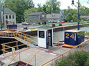
. The canal contains 36 locks and encompasses a total elevation differential of around 565 ft. (169 m). First proposed in 1807, it was under construction from 1817 to 1825 and officially opened on October 26, 1825.
It was the first transportation system between the eastern seaboard (New York City) and the western interior (Great Lakes) of the United States that did not require portage
, was faster than carts pulled by draft animals, and cut transport costs by about 95%. The canal fostered a population surge in western New York state, opened regions farther west to settlement, and helped New York City become the chief U.S. port. It was enlarged between 1834 and 1862. In 1918, the enlarged canal was replaced by the larger New York State Barge Canal.
Today, it is part of the New York State Canal System
. In 2000, the United States Congress
designated the Erie Canalway National Heritage Corridor to recognize the national significance of the canal system as the most successful and influential human-built waterway and one of the most important works of civil engineering and construction in North America. Mainly used by recreational watercraft in the recent past, the canal saw an upsurge in commercial traffic in 2008.
from the coast of North America into the heartland of the continent, a recurring problem was that of transportation between the coastal ports and the interior. Close to the seacoast, rivers often provided adequate waterways, but the presence of the Appalachian Mountains
, a few hundred miles inland, presented a great challenge. Passengers and freight had to travel overland, a journey made more difficult by the rough condition of the roads. That the principal exportable product of the Ohio Valley was grain did not help matters, as grain was a high-volume, low-priced commodity, frequently not worth the cost of transporting it to far-away population centers (this was a factor leading to the Whiskey Rebellion
). In the 18th and early 19th centuries, it became clear to coastal residents that the city or state that succeeded in developing a cheap, reliable route to the West would enjoy economic success, and that the port at the seaward end of such a route would see business increase greatly. In time, projects were devised in Virginia
, Maryland
, Pennsylvania
, and elsewhere.
 The extraordinary success of the Bridgewater Canal
in Britain, completed in 1761, led to a frenzy of canal building in England. The colonial idea of a canal or artificially improved waterway to tie the east coast to the new western settlements was in the air: in 1724, New York provincial official Cadwallader Colden
made a passing reference (in a report on fur trading) to improving the natural waterways of western New York. George Washington
led a serious effort to turn the Potomac River
into a navigable link to the west, sinking substantial energy and capital into the Patowmack Canal
from 1785 until his death fourteen years later. Christopher Colles, who was familiar with the Bridgewater Canal, surveyed the Mohawk valley and made a presentation to the New York state legislature in 1784 proposing a canal from Lake Ontario
. The proposal drew attention and some action, but ultimately came to nothing.
Gouverneur Morris
and Elkanah Watson
were other early proponents of a canal along the Mohawk. Their efforts led to creation of the Western Inland Lock Navigation Company, which took the first steps to improve navigation on the Mohawk, but the company proved that private financing was inadequate. In 1798, the Niagara Canal Company was incorporated.
The advocate who finally got the canal built was entrepreneur Jesse Hawley
. He envisioned growing huge quantities of grain on the Western New York plains, then largely unsettled, for sale on the Eastern Seaboard
. He went bankrupt, however, trying to ship it to the coast. While in Canandaigua
debtors' prison, he started pressing for the construction of a canal along the 90-mile-long Mohawk River
and valley. He had strong support from Joseph Ellicott
, agent for the Holland Land Company
in Batavia
. Ellicott realized that a canal would add immense value to the land he was selling in the western part of the state. Ellicott later became the first canal commissioner.
The Mohawk River, a tributary of the Hudson, runs in a glacial meltwater
channel across the Appalachians
in New York state, separating them into the Catskills and Adirondacks. The Mohawk Valley was the only cut across the Appalachians north of Alabama
, and led almost directly from the Hudson River in the east to Lake Ontario
and Lake Erie
in the west. From there, much of the interior and many settlements would be accessible by the Great Lakes
and related rivers.
The problem was that the land rises about 600 feet (182.9 m) from the Hudson to Lake Erie. Locks at the time could handle up to 12 feet (3.7 m), so at least fifty locks would be required along the 360 miles (579.4 km) canal. Such a canal would cost a fortune even today; in 1800 the expense was barely imaginable. President Jefferson
called it "a little short of madness" and rejected it. Nevertheless, Hawley managed to interest New York Governor DeWitt Clinton
. There was much opposition, and the project was scorned as "Clinton's Folly," or "Clinton's Ditch." But in 1817 Clinton got the legislature to appropriate $7 million for construction.
The original canal was 363 miles (584.2 km) long, from Albany
on the Hudson to Buffalo
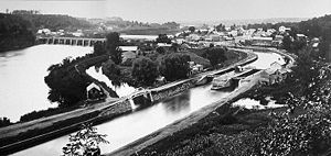
on Lake Erie. The channel was a cut 40 feet (12.2 m) wide and 4 feet (1.2 m) deep, with removed soil piled on the downhill side to form a walkway called the towpath. Canal boats, up to 3.5 feet (1.1 m) in draft, were pulled by horses and mules on the towpath. There was only one towpath, generally on the north side of the ditch. When canal boats met, the boat with right-of-way steered to the towpath side of the canal. The other boat steered toward the berm or heelpath side of the canal. The driver or "hoggee" of the privileged boat brought his team to the canalside edge of the towpath while the hoggee of the other boat moved to the outside of the towpath and stopped his team. His towline would go slack, fall into the water and sink to the bottom while his boat continued on by momentum. The privileged boat's team would step over the other boat's towline, and then their boat would pass over the sunken towline without stopping. Once clear, the other boat's team would continue on its way.
The Erie Canal started construction in 1817 and was completed 8 years later. It was the first commercial link between New York East and the West. The Erie Canal cost $7 million to construct and was acclaimed as one the greatest engineering marvels in the world. It united the country and help NYC become the financial state it is. In 1809 New York delegation went to Washington DC to propose a funding for the Canal. Thomas Jefferson said to come back in a 100 years because the project would bankrupt the nation let alone the state. Yet, Dewitt who was head of the committee who later became governor did not listen. There was a lot of political opposition, but in 1817 the canal bill was passed.
Reality hit when they realized that they had to build through limestone and mountains, battle water, and deal with other environmental factors. Malaria, borne by mosquitos killed over 1000 men who were working on the canal in a single season. The canal was built using one of the most engineering technology marvels from Holland. In 1823, the building reached Niagara escarpment and faced with the problem on how to flow water up. With the use of technology it built 5 locks that would fill the water and move the water and boat 12 ft each time until it reached the Erie Canal. The sides of the cut were lined with stone set in clay, and the bottom was also lined with clay. The stonework required hundreds of German mason
s, who later built many of New York's famous buildings.
All of the labor on the canal depended upon either human and animal power or the force of water. Engineering techniques developed during the building. To redirect water, the builders utilized the aqueduct, a structure for transporting water which was originally developed by the Ancient Romans. One aqueduct was 950 foot long to span 800 feet of river. As the canal progressed, the crews and engineers working on the project developed expertise and became a skilled labor force. The building of the locks at the Niagara escarpment also required specialized engineering skills to dig through solid rock and build a 3-mile corridor. To move earth, animals pulled a new type of Slip Scraper, akin to a bulldozer.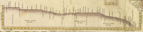
 Construction began July 4, 1817, at Rome, New York
. The first 15 miles (24.1 km), from Rome to Utica
, opened in 1819. At that rate the canal would not be finished for thirty years. The main problems were felling trees to clear a path through virgin forest and moving excavated soil, both of which took longer than expected, but the builders solved these problems. To fell a tree, they threw rope over the top branches and winched it down. They pulled out the stumps with an innovative stump puller. A pair of huge wheels were set loose on an axle. A large wheel, barely smaller than the others, was fixed to the center of the axle. A chain was wrapped around the axle and hooked to the stump. A rope was wrapped around the center wheel and hooked to a team of oxen. The mechanical advantage (torque
) obtained ripped the stumps out of the soil. Soil to be moved was shoveled into large wheelbarrows that were dumped into mule-pulled carts.
A three-man team with mules could build a mile in a year. The remaining problem was finding enough labor, and increased immigration helped fill the need. The men who planned and oversaw construction were novices, both as surveyors and as engineers. There were no civil engineer
s in the United States. James Geddes
and Benjamin Wright
, who laid out the route, were judges whose experience in surveying was in settling boundary disputes. Geddes had only used a surveying instrument for a few hours. Canvass White
was a 27-year-old amateur engineer who persuaded Clinton to let him go to Britain at his own expense to study the canal system there. Nathan Roberts was a mathematics
teacher and land speculator. Yet these men "carried the Erie Canal up the Niagara escarpment at Lockport
, maneuvered it onto a towering embankment to cross over Irondequoit Creek
, spanned the Genesee River
on an awesome aqueduct
, and carved a route for it out of the solid rock between Little Falls
and Schenectady—and all of those venturesome designs worked precisely as planned." (Bernstein, p. 381) Many of the laborers working on the canal were Scots Irish, who had recently come to the United States as a group of about 5,000 from Northern Ireland, most of whom were Protestants and wealthy enough to pay for this caravan.
 Construction continued at an increased rate as new workers arrived. When the canal reached Montezuma Marsh
(at the outlet of Cayuga Lake
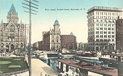
west of Syracuse
), over 1,000 workers died of swamp fever
and construction stopped. Work continued on the downhill side towards the Hudson, and when the marsh froze in winter, the crews worked to complete the section across the swamps.
The middle section from Utica to Salina
(Syracuse) was completed in 1820 and traffic on that section started up immediately. The eastern section, 250 miles (402.3 km) from Brockport
to Albany, opened on September 10, 1823 to great fanfare.
The Champlain Canal
, a 64 miles (103 km) north-south route from Watervliet
on the Hudson to Lake Champlain
, opened on the same date.
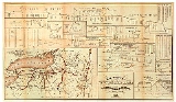
In 1824, before the canal was completed, a detailed Pocket Guide for the Tourist and Traveler, Along the Line of the Canals, and the Interior Commerce of the State of New York, was published for the benefit of travelers and land speculators — possibly America's first tour guide.
After Montezuma Marsh, the next obstacle was crossing the Niagara Escarpment
, an 80 feet (24.4 m) wall of hard dolomitic
limestone
, to rise to the level of Lake Erie. The route followed the channel of a creek that had cut a ravine steeply down the escarpment, with two sets of five locks in a series, giving rise to the community of Lockport
. These 12 feet (3.7 m) lift-locks had a total lift of 60 feet (18.3 m), exiting into a deeply cut channel. The final leg had to be cut 30 feet (9.1 m) through another limestone layer, the Onondaga ridge
. Much of that section was blasted with black powder. The inexperience of the crews often led to accidents, and sometimes rocks falling on nearby homes.
Two villages competed to be the terminus: Black Rock, on the Niagara River
, and Buffalo, at the eastern tip of Lake Erie. Buffalo expended great energy to widen and deepen Buffalo Creek
to make it navigable and to create a harbor at its mouth. Buffalo won over Black Rock, and grew into a large city, encompassing its former competitor.
Work was completed on October 26, 1825. The event was marked by a statewide "Grand Celebration," culminating in successive cannon
shots along the length of the canal and the Hudson, a 90-minute cannonade from Buffalo to New York City. A flotilla of boats, led by Governor Dewitt Clinton aboard the Seneca Chief, sailed from Buffalo to New York City in ten days. Clinton then ceremonially poured Lake Erie water into New York Harbor to mark the "Wedding of the Waters." On its return trip, the Seneca Chief brought a keg of Atlantic Ocean
water back to Buffalo to be poured into Lake Erie by Buffalo's Judge Samuel Wilkeson
, who would later become mayor.
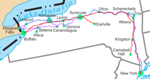
 The canal began on the west side of the Hudson River at Albany, and ran north to Watervliet
, where the Champlain Canal branched off. At Cohoes
, it climbed the escarpment on the west side of the Hudson River and then turned west along the south shore of the Mohawk River, crossing to the north side at Crescent
and again to the south at Rexford
. The canal continued west near the south shore of the Mohawk River all the way to Rome, where the Mohawk turns north.
At Rome, the canal continued west parallel to Wood Creek
, which flows westward into Oneida Lake
, and turned southwest and west cross-country to avoid the lake. From Canastota
west, it ran roughly along the north (lower) edge of the Onondaga Escarpment, passing through Syracuse and Rochester. Before reaching Rochester, the canal uses a series of natural ridges to cross the deep valley of Irondequoit Creek (a preglacial course of the Genesee River). At Lockport the canal turned southwest to rise to the top of the Niagara Escarpment
, using the ravine of Eighteenmile Creek
. The canal continued south-southwest to Pendleton
, where it turned west and southwest, mainly using the channel of Tonawanda Creek
. From Tonawanda south toward Buffalo, it ran just east of the Niagara River, where it reached its "Western Terminus" at Little Buffalo Creek (later it became the Commercial Slip
), which discharged into the Buffalo River
just above its confluence with Lake Erie
. With Buffalo's recent re-watering of the Commercial Slip
, a water route from the eastern terminus at Albany to the western terminus at Buffalo is once again open.
The Erie made use of the favorable conditions of New York's unique topography providing that area with the only break in the Appalachians
range south of the St. Lawrence River. A major feature of New York is that the Hudson River below Glens Falls follows a valley formed by geologic forces, not erosion. The Hudson is tidal to Troy and Albany is west of the Appalachians. It allowed for east-west navigation from the coast to the Great Lakes within US territory. The canal system thus gave New York State a competitive advantage, helped New York City develop as an international trade center, and allowed Buffalo to grow from just 200 settlers in 1820 to more than 18,000 people by 1840. The port of New York became essentially the Atlantic home port for all of the Midwest. It was because of this vital and critical connection that New York State would become known as the great "Empire State."
 Problems developed but were quickly solved. Leaks developed along the entire length of the canal, but these were sealed with a newly invented cement
that hardened underwater (hydraulic cement). Erosion on the clay bottom proved to be a problem and the speed was limited to 4 mph (6 km/h).
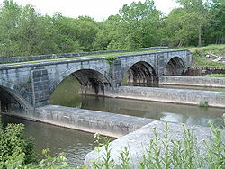
The original design planned for an annual tonnage of 1.5 million tons (1.36 million metric tons), but this was exceeded immediately. An ambitious program to improve the canal began in 1834. During this massive series of construction projects, known as the First Enlargement, the canal was widened to 70 feet (21.3 m) and deepened to 7 feet (2.1 m). Locks were widened and/or rebuilt in new locations, and many new aqueducts were constructed. The canal was straightened and slightly re-routed in some stretches, resulting in the abandonment of short segments of the original 1825 canal. The First Enlargement was completed in 1862, with further minor enlargements in later decades.
Today, the reconfiguration of the canal created during the First Enlargement is commonly referred to as the Improved Erie Canal or the Old Erie Canal
, to distinguish it from the canal's modern-day course. Existing remains of the 1825 canal abandoned during the Enlargement are sometimes referred to today as Clinton's Ditch (which was also the popular nickname for the entire Erie Canal project during its original 1817-1825 construction).
Additional feeder canals soon extended the Erie Canal into a system. These included the Cayuga-Seneca Canal south to the Finger Lakes
, the Oswego Canal from Three Rivers north to Lake Ontario at Oswego
, and the Champlain Canal from Troy north to Lake Champlain. From 1833 to 1877, the short Crooked Lake Canal connected Keuka Lake
and Seneca Lake. The Chemung Canal
connected the south end of Seneca Lake to Elmira
in 1833, and was an important route for Pennsylvania coal
and timber
into the canal system. The Chenango Canal
in 1836 connected the Erie Canal at Utica to Binghamton
and caused a business boom in the Chenango River
valley. The Chenango and Chemung canals linked the Erie with the Susquehanna River
system. The Black River Canal
connected the Black River
to the Erie Canal at Rome and remained in operation until the 1920s. The Genesee Valley Canal
was run along the Genesee River
to connect with the Allegheny River
at Olean
, but the Allegheny section, which would have connected to the Ohio and Mississippi rivers, was never built. The Genesee Valley Canal was later abandoned and became the route of the Genesee Valley Canal Railroad
.
In 1903, the New York state legislature authorized construction of the New York State Barge Canal as the "Improvement of the Erie, the Oswego, the Champlain, and the Cayuga and Seneca Canals".
In 1905, construction of the Barge Canal began, which was completed in 1918, at a cost of $96.7 million.
Freight traffic reached a total of 5.2 million short tons (4.7 million metric tons) by 1951, before declining in the face of combined rail and truck competition.
 As the canal brought travelers to New York City, it took business away from other ports such as Philadelphia, Pennsylvania
, and Baltimore, Maryland. Those cities and their states chartered projects to compete with the Erie Canal. In Pennsylvania, the Main Line of Public Works
was a combined canal and railroad running west from Philadelphia to Pittsburgh
on the Ohio River
, opened in 1834. In Maryland, the Baltimore and Ohio Railroad
ran west to Wheeling, West Virginia
, also on the Ohio River, and was completed in 1853.
Other competition was more direct. The Mohawk and Hudson Railroad opened in 1837, providing a bypass to the slowest part of the canal between Albany and Schenectady. Other railroads were soon chartered and built to continue the line west to Buffalo, and in 1842 a continuous line (which later became the New York Central Railroad
and its Auburn Road in 1853) was open the whole way to Buffalo. As the railroad served the same general route as the canal, but provided for faster travel, passengers soon switched to it. However as late as 1852, the canal carried thirteen times more freight tonnage than all the railroads in New York state combined; it continued to compete well with the railroads through 1882, when tolls were abolished.
The New York, West Shore and Buffalo Railway was completed in 1884, as a route running closely parallel to both the canal and the New York Central Railroad
. However, it went bankrupt and was acquired the next year by the New York Central.
 The Erie Canal made an immense contribution to the wealth and importance of New York City, Buffalo, and New York State. Its impact went much further, increasing trade throughout the nation by opening eastern and overseas markets to Midwestern farm products and by enabling migration to the West. New ethnic Irish communities formed in some towns along its route after completion, as Irish immigrants were a large portion of the construction labor force. Earth extracted from the canal was transported to the New York city area and used as landfill in New York and New Jersey. A plaque honoring the canal's construction is located in Battery Park
in southern Manhattan.
Because so many immigrants traveled on the canal, many genealogists have sought copies of canal passenger lists. Apart from the years 1827–1829, canal boat operators were not required to record or report passenger names to the government, which, in this case, was the State of New York. Those 1827–1829 passenger lists survive today in the New York State Archives, and other sources of traveler information are sometimes available.
The Canal also helped bind the still-new nation closer to Britain and Europe. British repeal of the Corn Law resulted in a huge increase in exports of Midwestern wheat to Britain. Trade between the US and Canada also increased as a result of the Corn Law and a reciprocity (free-trade) agreement signed in 1854; much of this trade flowed along the Erie.
Its success also prompted imitation: a rash of canal-building followed. Also, the many technical hurdles that had to be overcome made heroes of those whose innovations made the canal possible. This led to an increased public esteem for practical education. Chicago
, among other Great Lakes
cities, recognized the commercial importance of the canal to its economy, and two West Loop
streets are named Canal and Clinton (for canal proponent DeWitt Clinton).
Concern that erosion caused by logging in the Adirondacks
could silt up the canal contributed to the creation of another New York National Historic Landmark, the Adirondack Park, in 1885.
Many notable authors wrote about the canal, including Herman Melville
, Frances Trollope
, Nathaniel Hawthorne
, Harriet Beecher Stowe
, Mark Twain
, Samuel Hopkins Adams
and the Marquis de Lafayette, and many tales and songs were written about life on the canal. The popular song "Low Bridge" by Thomas S. Allen
was written in 1905 to memorialize the canal's early heyday, when barges were pulled by mules rather than engines.
 In 1918, the Canal was replaced by the larger New York State Barge Canal
. This new canal replaced much of the original route, leaving many abandoned sections (most notably between Syracuse and Rome). New digging and flood control technologies allowed engineers to canalize rivers that the original canal sought to avoid, such as the Mohawk, Seneca
, and Clyde rivers, and Oneida Lake. In sections which did not consist of canalized rivers (particularly between Rochester and Buffalo), the original Erie Canal channel was enlarged to 120 feet (36.6 m) wide and 12 feet (3.7 m) deep. The expansion allowed barges up to 2000 short tons (1,814.4 t) to use the Canal. This expensive project was politically unpopular in parts of the state not served by the canal, and failed to save it from becoming obsolete.
The new alignment began on the Hudson River at the border between Cohoes and Waterford, where it ran northwest with five locks, running into the Mohawk east of Crescent. While the old Canal ran next to the Mohawk all the way to Rome, the new canal ran through the river, straightened or widened where necessary. At Ilion
the new canal left the river for good, but continued to run on a new alignment parallel to both the river and the old canal to Rome. From Rome, the new route continued almost due west, merging with Fish Creek just east of its entry into Oneida Lake.
From Oneida Lake, the new canal ran west along the Oneida River
, with cutoffs to shorten the route. At Three Rivers the Oneida River turns northwest, and was deepened for the Oswego Canal to Lake Ontario. The new Erie Canal turned south there along the Seneca River, which turns west near Syracuse and continues west to a point in the Montezuma Marsh (43.00296°N 76.73115°W). There the Cayuga and Seneca Canal continued south with the Seneca River, and the new Erie Canal again ran parallel to the old Canal along the bottom of the Niagara Escarpment, in some places running along the Clyde River, and in some places replacing the old Canal. At Pittsford
, southeast of Rochester, the Canal turned west to run around the south side of Rochester, rather than through downtown. The Canal currently crosses the Genesee River
at the Genesee Valley Park
(43.1215°N 77.6425°W), then rejoins the old path near North Gates.
From there it was again roughly an upgrade to the original canal, running west to Lockport. This reach of 64.2 miles from Henrietta to Lockport is called "the 60-mile level" since there are no locks and the water level rises only two feet over the entire segment. Diversions from and to adjacent natural streams along the way are used to maintain the canal's level. It runs southwest to Tonawanda, where the new alignment discharges into the Niagara River, which is navigable upstream to the New York Barge Canal's Black Rock Lock
and thence to the Canal's original "Western Terminus" at Buffalo's Inner Harbor
.
The growth of railroads and highways across the state, and the opening of the Saint Lawrence Seaway
, caused commercial traffic on the canal to decline dramatically during the second half of the 20th century.
(including the Erie, Cayuga-Seneca
, Oswego, and Champlain canals) and placed under the newly created New York State Canal Corporation
, a subsidiary of the New York State Thruway Authority
. The Canal System is operated using money generated by Thruway tolls.
 Since the 1990s, the Canal system has been used primarily by recreational traffic, although a small but growing amount of cargo traffic still uses it.
Today, the Erie Canal Corridor covers 524 miles (843.3 km) of navigable water from Lake Champlain to the Capital Region
and west to Buffalo. The area has a population of 2.7 million: about 75% of Central and Western New York's population lives within 25 miles (40.2 km) of the Erie Canal.
The Erie Canal is open to small craft and some larger vessels from May through November each year. During winter, water is drained from parts of the canal for maintenance. The Champlain Canal, Lake Champlain, and the Chambly Canal
and Richelieu River
in Canada form the Lakes to Locks Passage
, making a tourist attraction of the former waterway linking eastern Canada to the Erie Canal. In 2006, recreational boating fees were eliminated to attract more visitors.
Travel on the Canal's middle section (particularly in the Mohawk Valley) was severely hampered by flooding in late June and early July 2006. Flood damage to the canal and its facilities was estimated as at least $15 million.
There were some 42 commercial shipments on the canal in 2008, compared to 15 such shipments in 2007 and more than 33,000 shipments in 1855, the canal's peak year. According to the New York Times, the new growth in commercial traffic is due to the rising cost of diesel fuel. Canal barges can carry a short ton of cargo 514 miles on one gallon of diesel fuel, while a gallon allows a train to haul the same amount of cargo 202 miles and a truck 59 miles. Canal barges can carry loads up to 3,000 short tons and are used to transport objects that would be too large for road or rail shipment. The system is served by several commercial towing companies.
 Sections of the old Erie Canal abandoned after 1918 are owned by New York state or have been ceded to or purchased by counties or municipalities. Many stretches of the old canal have been filled in to create roads such as Erie Boulevard in Syracuse and Schenectady, and Broad Street and the Rochester Subway
in Rochester. A 36-mile (58 km) stretch of the old canal is preserved by New York State as Old Erie Canal State Historic Park
. In 1960 the Schoharie Crossing State Historic Site
, a section of the canal in Montgomery County
, was one of the first sites recognized as a National Historic Landmark
.
Some municipalities have preserved sections as town or county canal parks, or have plans to do so. Camillus Erie Canal Park
preserves a 7 miles (11.3 km) stretch and the city plans to restore Nine Mile Creek Aqueduct
, built in 1841 as part of the First Enlargement of the canal. In some communities, the old canal has refilled with overgrowth and debris. Proposals have been made to rehydrate the old canal through downtown Rochester or Syracuse as a tourist attraction
. In Syracuse, the location of the old canal is represented by a reflecting pool in downtown's Clinton Square and the downtown hosts a canal barge and weigh lock
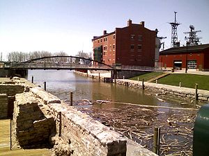
structure, now dry. Buffalo's Commercial Slip
is the recently restored and re-watered segment of the canal which formed its "Western Terminus".
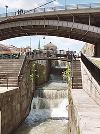
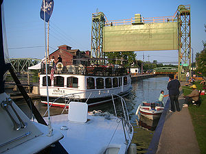
The Erie Canal is a destination for tourists from all over the world. An Erie Canal Cruise company, based in Herkimer, operates from mid-May until mid-October with daily cruises. The cruise goes through the history of the canal and also takes passengers through Lock 18.
In 2004, the administration of New York Governor George Pataki
was criticized when officials of New York State Canal Corporation attempted to sell private development rights to large stretches of the Old Erie Canal to a single developer for US$30,000, far less than the land was worth on the open market. After an investigation by the Syracuse Post-Standard
newspaper, the Pataki administration nullified the deal.
 The creation of a unified, statewide Erie Canal historic trail or greenway
to attract tourism has been an elusive goal since it was first proposed in the 1990s. But, many communities along the old Erie Canal have made progress in establishing parks, improving towpaths and raising funds for restoration of old canal structures such as locks and aqueducts. Biking, hiking, snowmobiling, cross-country skiing, horseback riding, canoeing and fishing are among activities promoted.
Records of the planning, design, construction and administration of the Erie Canal are vast and can be found in the New York State Archives. Except for two years (1827–1829), the State of New York did not require canal boat operators to maintain or submit passenger lists.
is provided for the current canal, from east to west:
Note: There is no Lock 1 or Lock 31 on the Erie Canal. The place of "Lock 1" on the passage from the lower Hudson to Lake Erie is taken by the Federal Lock, located just north of Troy, NY, and is not part of the Erie Canal System proper.
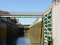
*Note: The Black Rock Lock
is in the New York State Barge Canal, and allows passage beside the Niagara River to the Erie Canal's "Western Terminus" at the Commercial Slip
. Upstream and downstream water levels, as well as Black Rock Lock's lift, vary with the naturally fluctuating levels of Lake Erie and the Niagara River. Although a portion of the Erie Canal through Buffalo has been filled in, travel by water is still possible, from the Commercial Slip, through Buffalo's Inner Harbor and the Black Rock Lock, to Tonawanda, NY
, Lockport, and eastward to Albany.
Images and maps
Parks and museums
Albany, New York
Albany is the capital city of the U.S. state of New York, the seat of Albany County, and the central city of New York's Capital District. Roughly north of New York City, Albany sits on the west bank of the Hudson River, about south of its confluence with the Mohawk River...
, on the Hudson River
Hudson River
The Hudson is a river that flows from north to south through eastern New York. The highest official source is at Lake Tear of the Clouds, on the slopes of Mount Marcy in the Adirondack Mountains. The river itself officially begins in Henderson Lake in Newcomb, New York...
to Buffalo, New York
Buffalo, New York
Buffalo is the second most populous city in the state of New York, after New York City. Located in Western New York on the eastern shores of Lake Erie and at the head of the Niagara River across from Fort Erie, Ontario, Buffalo is the seat of Erie County and the principal city of the...
, at Lake Erie
Lake Erie
Lake Erie is the fourth largest lake of the five Great Lakes in North America, and the tenth largest globally. It is the southernmost, shallowest, and smallest by volume of the Great Lakes and therefore also has the shortest average water residence time. It is bounded on the north by the...
, completing a navigable water route from the Atlantic Ocean to the Great Lakes
Great Lakes
The Great Lakes are a collection of freshwater lakes located in northeastern North America, on the Canada – United States border. Consisting of Lakes Superior, Michigan, Huron, Erie, and Ontario, they form the largest group of freshwater lakes on Earth by total surface, coming in second by volume...
. The canal contains 36 locks and encompasses a total elevation differential of around 565 ft. (169 m). First proposed in 1807, it was under construction from 1817 to 1825 and officially opened on October 26, 1825.
It was the first transportation system between the eastern seaboard (New York City) and the western interior (Great Lakes) of the United States that did not require portage
Portage
Portage or portaging refers to the practice of carrying watercraft or cargo over land to avoid river obstacles, or between two bodies of water. A place where this carrying occurs is also called a portage; a person doing the carrying is called a porter.The English word portage is derived from the...
, was faster than carts pulled by draft animals, and cut transport costs by about 95%. The canal fostered a population surge in western New York state, opened regions farther west to settlement, and helped New York City become the chief U.S. port. It was enlarged between 1834 and 1862. In 1918, the enlarged canal was replaced by the larger New York State Barge Canal.
Today, it is part of the New York State Canal System
New York State Canal System
The New York State Canal System is a successor to the Erie Canal and other canals within New York...
. In 2000, the United States Congress
United States Congress
The United States Congress is the bicameral legislature of the federal government of the United States, consisting of the Senate and the House of Representatives. The Congress meets in the United States Capitol in Washington, D.C....
designated the Erie Canalway National Heritage Corridor to recognize the national significance of the canal system as the most successful and influential human-built waterway and one of the most important works of civil engineering and construction in North America. Mainly used by recreational watercraft in the recent past, the canal saw an upsurge in commercial traffic in 2008.
Background
From the first days of the expansion of the English coloniesThirteen Colonies
The Thirteen Colonies were English and later British colonies established on the Atlantic coast of North America between 1607 and 1733. They declared their independence in the American Revolution and formed the United States of America...
from the coast of North America into the heartland of the continent, a recurring problem was that of transportation between the coastal ports and the interior. Close to the seacoast, rivers often provided adequate waterways, but the presence of the Appalachian Mountains
Appalachian Mountains
The Appalachian Mountains #Whether the stressed vowel is or ,#Whether the "ch" is pronounced as a fricative or an affricate , and#Whether the final vowel is the monophthong or the diphthong .), often called the Appalachians, are a system of mountains in eastern North America. The Appalachians...
, a few hundred miles inland, presented a great challenge. Passengers and freight had to travel overland, a journey made more difficult by the rough condition of the roads. That the principal exportable product of the Ohio Valley was grain did not help matters, as grain was a high-volume, low-priced commodity, frequently not worth the cost of transporting it to far-away population centers (this was a factor leading to the Whiskey Rebellion
Whiskey Rebellion
The Whiskey Rebellion, or Whiskey Insurrection, was a tax protest in the United States in the 1790s, during the presidency of George Washington. Farmers who sold their corn in the form of whiskey had to pay a new tax which they strongly resented...
). In the 18th and early 19th centuries, it became clear to coastal residents that the city or state that succeeded in developing a cheap, reliable route to the West would enjoy economic success, and that the port at the seaward end of such a route would see business increase greatly. In time, projects were devised in Virginia
Patowmack Canal
The Patowmack Canal is an inoperative canal located in Virginia, United States, that was designed to bypass rapids in the Potomac River upstream of the present Washington, D.C. area...
, Maryland
Chesapeake and Ohio Canal
The Chesapeake and Ohio Canal, abbreviated as the C&O Canal, and occasionally referred to as the "Grand Old Ditch," operated from 1831 until 1924 parallel to the Potomac River in Maryland from Cumberland, Maryland to Washington, D.C. The total length of the canal is about . The elevation change of...
, Pennsylvania
Main Line of Public Works
The Main Line of Public Works was a railroad and canal system built by the Commonwealth of Pennsylvania in the 19th century. It ran from Philadelphia west through Harrisburg and across the state to Pittsburgh and connected with other divisions of the Pennsylvania Canal...
, and elsewhere.
Proposal and logistics
Bridgewater Canal
The Bridgewater Canal connects Runcorn, Manchester and Leigh, in North West England. It was commissioned by Francis Egerton, 3rd Duke of Bridgewater, to transport coal from his mines in Worsley to Manchester...
in Britain, completed in 1761, led to a frenzy of canal building in England. The colonial idea of a canal or artificially improved waterway to tie the east coast to the new western settlements was in the air: in 1724, New York provincial official Cadwallader Colden
Cadwallader Colden
Cadwallader Colden was a physician, farmer, surveyor, botanist, and a lieutenant governor for the Province of New York.-Biography:...
made a passing reference (in a report on fur trading) to improving the natural waterways of western New York. George Washington
George Washington
George Washington was the dominant military and political leader of the new United States of America from 1775 to 1799. He led the American victory over Great Britain in the American Revolutionary War as commander-in-chief of the Continental Army from 1775 to 1783, and presided over the writing of...
led a serious effort to turn the Potomac River
Potomac River
The Potomac River flows into the Chesapeake Bay, located along the mid-Atlantic coast of the United States. The river is approximately long, with a drainage area of about 14,700 square miles...
into a navigable link to the west, sinking substantial energy and capital into the Patowmack Canal
Patowmack Canal
The Patowmack Canal is an inoperative canal located in Virginia, United States, that was designed to bypass rapids in the Potomac River upstream of the present Washington, D.C. area...
from 1785 until his death fourteen years later. Christopher Colles, who was familiar with the Bridgewater Canal, surveyed the Mohawk valley and made a presentation to the New York state legislature in 1784 proposing a canal from Lake Ontario
Lake Ontario
Lake Ontario is one of the five Great Lakes of North America. It is bounded on the north and southwest by the Canadian province of Ontario, and on the south by the American state of New York. Ontario, Canada's most populous province, was named for the lake. In the Wyandot language, ontarío means...
. The proposal drew attention and some action, but ultimately came to nothing.
Gouverneur Morris
Gouverneur Morris
Gouverneur Morris , was an American statesman, a Founding Father of the United States, and a native of New York City who represented Pennsylvania in the Constitutional Convention of 1787. He was a signatory to the Articles of Confederation. Morris was also an author of large sections of the...
and Elkanah Watson
Elkanah Watson
Elkanah Watson was a visionary traveller and writer, agriculturist and canal promoter. He was born in Plymouth, Massachusetts and died at Port Kent, New York. During the American Revolutionary War he carried dispatches to Benjamin Franklin in France...
were other early proponents of a canal along the Mohawk. Their efforts led to creation of the Western Inland Lock Navigation Company, which took the first steps to improve navigation on the Mohawk, but the company proved that private financing was inadequate. In 1798, the Niagara Canal Company was incorporated.
The advocate who finally got the canal built was entrepreneur Jesse Hawley
Jesse Hawley (merchant)
Jesse Hawley was a flour merchant in Geneva, New York who became an early and major proponent of building of the Erie Canal.Struggling to receive shipments and make deliveries over the wretched roadways of the era, Hawley imagined the canal as early as 1805...
. He envisioned growing huge quantities of grain on the Western New York plains, then largely unsettled, for sale on the Eastern Seaboard
Eastern seaboard
An Eastern seaboard can mean any easternmost part of a continent, or its countries, states and/or cities.Eastern seaboard may also refer to:* East Coast of Australia* East Coast of the United States* Eastern Seaboard of Thailand-See also:...
. He went bankrupt, however, trying to ship it to the coast. While in Canandaigua
Canandaigua (city), New York
Canandaigua is a city in Ontario County, New York, USA, of which it is the county seat. The population was 11,264 at the 2000 census...
debtors' prison, he started pressing for the construction of a canal along the 90-mile-long Mohawk River
Mohawk River
The Mohawk River is a river in the U.S. state of New York. It is the largest tributary of the Hudson River. The Mohawk flows into the Hudson in the Capital District, a few miles north of the city of Albany. The river is named for the Mohawk Nation of the Iroquois Confederacy...
and valley. He had strong support from Joseph Ellicott
Joseph Ellicott
Joseph Ellicott was an American surveyor, city planner, land office agent, lawyer and politician of the Quaker faith.-Life:He was the son of Joseph Ellicott ....
, agent for the Holland Land Company
Holland Land Company
The Holland Land Company was a purchaser of the western two-thirds of the western New York land tract known as the Phelps and Gorham Purchase. This tract was known thereafter as The Holland Purchase...
in Batavia
Batavia (city), New York
Batavia is a city in Genesee County, Western New York, USA, located near the middle of Genesee County, entirely within the Town of Batavia. Its population as of the 2000 census was 16,256...
. Ellicott realized that a canal would add immense value to the land he was selling in the western part of the state. Ellicott later became the first canal commissioner.
The Mohawk River, a tributary of the Hudson, runs in a glacial meltwater
Ice age
An ice age or, more precisely, glacial age, is a generic geological period of long-term reduction in the temperature of the Earth's surface and atmosphere, resulting in the presence or expansion of continental ice sheets, polar ice sheets and alpine glaciers...
channel across the Appalachians
Appalachian Mountains
The Appalachian Mountains #Whether the stressed vowel is or ,#Whether the "ch" is pronounced as a fricative or an affricate , and#Whether the final vowel is the monophthong or the diphthong .), often called the Appalachians, are a system of mountains in eastern North America. The Appalachians...
in New York state, separating them into the Catskills and Adirondacks. The Mohawk Valley was the only cut across the Appalachians north of Alabama
Alabama
Alabama is a state located in the southeastern region of the United States. It is bordered by Tennessee to the north, Georgia to the east, Florida and the Gulf of Mexico to the south, and Mississippi to the west. Alabama ranks 30th in total land area and ranks second in the size of its inland...
, and led almost directly from the Hudson River in the east to Lake Ontario
Lake Ontario
Lake Ontario is one of the five Great Lakes of North America. It is bounded on the north and southwest by the Canadian province of Ontario, and on the south by the American state of New York. Ontario, Canada's most populous province, was named for the lake. In the Wyandot language, ontarío means...
and Lake Erie
Lake Erie
Lake Erie is the fourth largest lake of the five Great Lakes in North America, and the tenth largest globally. It is the southernmost, shallowest, and smallest by volume of the Great Lakes and therefore also has the shortest average water residence time. It is bounded on the north by the...
in the west. From there, much of the interior and many settlements would be accessible by the Great Lakes
Great Lakes
The Great Lakes are a collection of freshwater lakes located in northeastern North America, on the Canada – United States border. Consisting of Lakes Superior, Michigan, Huron, Erie, and Ontario, they form the largest group of freshwater lakes on Earth by total surface, coming in second by volume...
and related rivers.
The problem was that the land rises about 600 feet (182.9 m) from the Hudson to Lake Erie. Locks at the time could handle up to 12 feet (3.7 m), so at least fifty locks would be required along the 360 miles (579.4 km) canal. Such a canal would cost a fortune even today; in 1800 the expense was barely imaginable. President Jefferson
Thomas Jefferson
Thomas Jefferson was the principal author of the United States Declaration of Independence and the Statute of Virginia for Religious Freedom , the third President of the United States and founder of the University of Virginia...
called it "a little short of madness" and rejected it. Nevertheless, Hawley managed to interest New York Governor DeWitt Clinton
DeWitt Clinton
DeWitt Clinton was an early American politician and naturalist who served as United States Senator and the sixth Governor of New York. In this last capacity he was largely responsible for the construction of the Erie Canal...
. There was much opposition, and the project was scorned as "Clinton's Folly," or "Clinton's Ditch." But in 1817 Clinton got the legislature to appropriate $7 million for construction.
The original canal was 363 miles (584.2 km) long, from Albany
Albany, New York
Albany is the capital city of the U.S. state of New York, the seat of Albany County, and the central city of New York's Capital District. Roughly north of New York City, Albany sits on the west bank of the Hudson River, about south of its confluence with the Mohawk River...
on the Hudson to Buffalo
Buffalo, New York
Buffalo is the second most populous city in the state of New York, after New York City. Located in Western New York on the eastern shores of Lake Erie and at the head of the Niagara River across from Fort Erie, Ontario, Buffalo is the seat of Erie County and the principal city of the...
on Lake Erie. The channel was a cut 40 feet (12.2 m) wide and 4 feet (1.2 m) deep, with removed soil piled on the downhill side to form a walkway called the towpath. Canal boats, up to 3.5 feet (1.1 m) in draft, were pulled by horses and mules on the towpath. There was only one towpath, generally on the north side of the ditch. When canal boats met, the boat with right-of-way steered to the towpath side of the canal. The other boat steered toward the berm or heelpath side of the canal. The driver or "hoggee" of the privileged boat brought his team to the canalside edge of the towpath while the hoggee of the other boat moved to the outside of the towpath and stopped his team. His towline would go slack, fall into the water and sink to the bottom while his boat continued on by momentum. The privileged boat's team would step over the other boat's towline, and then their boat would pass over the sunken towline without stopping. Once clear, the other boat's team would continue on its way.
The Erie Canal started construction in 1817 and was completed 8 years later. It was the first commercial link between New York East and the West. The Erie Canal cost $7 million to construct and was acclaimed as one the greatest engineering marvels in the world. It united the country and help NYC become the financial state it is. In 1809 New York delegation went to Washington DC to propose a funding for the Canal. Thomas Jefferson said to come back in a 100 years because the project would bankrupt the nation let alone the state. Yet, Dewitt who was head of the committee who later became governor did not listen. There was a lot of political opposition, but in 1817 the canal bill was passed.
Reality hit when they realized that they had to build through limestone and mountains, battle water, and deal with other environmental factors. Malaria, borne by mosquitos killed over 1000 men who were working on the canal in a single season. The canal was built using one of the most engineering technology marvels from Holland. In 1823, the building reached Niagara escarpment and faced with the problem on how to flow water up. With the use of technology it built 5 locks that would fill the water and move the water and boat 12 ft each time until it reached the Erie Canal. The sides of the cut were lined with stone set in clay, and the bottom was also lined with clay. The stonework required hundreds of German mason
Masonry
Masonry is the building of structures from individual units laid in and bound together by mortar; the term masonry can also refer to the units themselves. The common materials of masonry construction are brick, stone, marble, granite, travertine, limestone; concrete block, glass block, stucco, and...
s, who later built many of New York's famous buildings.
All of the labor on the canal depended upon either human and animal power or the force of water. Engineering techniques developed during the building. To redirect water, the builders utilized the aqueduct, a structure for transporting water which was originally developed by the Ancient Romans. One aqueduct was 950 foot long to span 800 feet of river. As the canal progressed, the crews and engineers working on the project developed expertise and became a skilled labor force. The building of the locks at the Niagara escarpment also required specialized engineering skills to dig through solid rock and build a 3-mile corridor. To move earth, animals pulled a new type of Slip Scraper, akin to a bulldozer.
Construction
Rome, New York
Rome is a city in Oneida County, New York, United States. It is located in north-central or "upstate" New York. The population was 44,797 at the 2010 census. It is in New York's 24th congressional district. In 1758, British forces began construction of Fort Stanwix at this strategic location, but...
. The first 15 miles (24.1 km), from Rome to Utica
Utica, New York
Utica is a city in and the county seat of Oneida County, New York, United States. The population was 62,235 at the 2010 census, an increase of 2.6% from the 2000 census....
, opened in 1819. At that rate the canal would not be finished for thirty years. The main problems were felling trees to clear a path through virgin forest and moving excavated soil, both of which took longer than expected, but the builders solved these problems. To fell a tree, they threw rope over the top branches and winched it down. They pulled out the stumps with an innovative stump puller. A pair of huge wheels were set loose on an axle. A large wheel, barely smaller than the others, was fixed to the center of the axle. A chain was wrapped around the axle and hooked to the stump. A rope was wrapped around the center wheel and hooked to a team of oxen. The mechanical advantage (torque
Torque
Torque, moment or moment of force , is the tendency of a force to rotate an object about an axis, fulcrum, or pivot. Just as a force is a push or a pull, a torque can be thought of as a twist....
) obtained ripped the stumps out of the soil. Soil to be moved was shoveled into large wheelbarrows that were dumped into mule-pulled carts.
A three-man team with mules could build a mile in a year. The remaining problem was finding enough labor, and increased immigration helped fill the need. The men who planned and oversaw construction were novices, both as surveyors and as engineers. There were no civil engineer
Civil engineer
A civil engineer is a person who practices civil engineering; the application of planning, designing, constructing, maintaining, and operating infrastructures while protecting the public and environmental health, as well as improving existing infrastructures that have been neglected.Originally, a...
s in the United States. James Geddes
James Geddes (engineer)
James Geddes was born in Carlisle, Pennsylvania and was a prominent engineer, surveyor, New York State legislator and U.S. Congressman who was instrumental in the planning of the Erie Canal and other canals in the United States...
and Benjamin Wright
Benjamin Wright
Benjamin Wright was an American civil engineer who served as Chief Engineer of both the Erie Canal and Chesapeake and Ohio Canal. In 1969 he was declared the "Father of American Civil Engineering" by the American Society of Civil Engineers.Wright was born in Wethersfield, Connecticut to Ebenezer...
, who laid out the route, were judges whose experience in surveying was in settling boundary disputes. Geddes had only used a surveying instrument for a few hours. Canvass White
Canvass White
Canvass White was an American engineer and inventor. He was chief engineer at the Delaware and Raritan Canal and he patented a type of hydraulic cement.-Birth:He was born on September 8, 1790, in Whitestown, New York...
was a 27-year-old amateur engineer who persuaded Clinton to let him go to Britain at his own expense to study the canal system there. Nathan Roberts was a mathematics
Mathematics
Mathematics is the study of quantity, space, structure, and change. Mathematicians seek out patterns and formulate new conjectures. Mathematicians resolve the truth or falsity of conjectures by mathematical proofs, which are arguments sufficient to convince other mathematicians of their validity...
teacher and land speculator. Yet these men "carried the Erie Canal up the Niagara escarpment at Lockport
Lockport (city), New York
Lockport is a city in Niagara County, New York, United States. The population was 21,165 at the 2010 census. The name is derived from a set of Erie canal locks within the city. Lockport is the county seat of Niagara County and is surrounded by the town of Lockport...
, maneuvered it onto a towering embankment to cross over Irondequoit Creek
Irondequoit Creek
Irondequoit Creek is a stream in eastern Monroe County, New York that feeds Irondequoit Bay. It actually begins in rural West Bloomfield in Ontario County, flowing north into the town of Mendon in Monroe County...
, spanned the Genesee River
Genesee River
The Genesee River is a North American river flowing northward through the Twin Tiers of Pennsylvania and New York. The river provided the original power for the Rochester area's 19th century mills and still provides hydroelectric power for downtown Rochester....
on an awesome aqueduct
Aqueduct
An aqueduct is a water supply or navigable channel constructed to convey water. In modern engineering, the term is used for any system of pipes, ditches, canals, tunnels, and other structures used for this purpose....
, and carved a route for it out of the solid rock between Little Falls
Little Falls (city), New York
Little Falls is a city in Herkimer County, New York, USA. The population was 5,188 at the 2000 census. The name is derived from a small cataract near the city....
and Schenectady—and all of those venturesome designs worked precisely as planned." (Bernstein, p. 381) Many of the laborers working on the canal were Scots Irish, who had recently come to the United States as a group of about 5,000 from Northern Ireland, most of whom were Protestants and wealthy enough to pay for this caravan.
Montezuma Marsh
Montezuma Marsh is a marsh at the northern end of Cayuga Lake in the Finger Lakes region of New York. Much of the marsh is part of the Montezuma National Wildlife Refuge, which is a major point on the route of many migratory birds, such as Canada geese and mallard ducks.The Cayuga valley is an old...
(at the outlet of Cayuga Lake
Cayuga Lake
Cayuga Lake is the longest of central New York's glacial Finger Lakes, and is the second largest in surface area and second largest in volume. It is just under 40 miles long. Its average width is 1.7 miles , and it is at its widest point near Aurora...
west of Syracuse
Syracuse, New York
Syracuse is a city in and the county seat of Onondaga County, New York, United States, the largest U.S. city with the name "Syracuse", and the fifth most populous city in the state. At the 2010 census, the city population was 145,170, and its metropolitan area had a population of 742,603...
), over 1,000 workers died of swamp fever
Swamp fever
Swamp fever is a term given to a number of diseases that are acquired in wet, swampy environments. Swamp fever may refer to:* Leptospirosis* Malaria* Equine infectious anemia...
and construction stopped. Work continued on the downhill side towards the Hudson, and when the marsh froze in winter, the crews worked to complete the section across the swamps.
The middle section from Utica to Salina
Salina, New York
Salina is a town in Onondaga County, New York, United States. The population was 33,290 at the 2000 census. The name of the town is derived from the Latin word for "salt."...
(Syracuse) was completed in 1820 and traffic on that section started up immediately. The eastern section, 250 miles (402.3 km) from Brockport
Brockport, New York
Brockport is a village located in the Town of Sweden in Monroe County, New York, USA. The population was 8,103 at the 2000 census. The name is derived from Hiel Brockway, an early settler....
to Albany, opened on September 10, 1823 to great fanfare.
The Champlain Canal
Champlain Canal
The Champlain Canal is a canal that connects the south end of Lake Champlain to the Hudson River in New York. It was simultaneously constructed with the Erie Canal and is now part of the New York State Canal System and the Lakes to Locks Passage....
, a 64 miles (103 km) north-south route from Watervliet
Watervliet, New York
Watervliet is a city in Albany County in the US state of New York. The population was 10,254 as of the 2010 census. Watervliet is north of Albany, the capital of the state, and is bordered on the north, west, and south by the town of Colonie. The city is also known as "the Arsenal City".- History...
on the Hudson to Lake Champlain
Lake Champlain
Lake Champlain is a natural, freshwater lake in North America, located mainly within the borders of the United States but partially situated across the Canada—United States border in the Canadian province of Quebec.The New York portion of the Champlain Valley includes the eastern portions of...
, opened on the same date.
In 1824, before the canal was completed, a detailed Pocket Guide for the Tourist and Traveler, Along the Line of the Canals, and the Interior Commerce of the State of New York, was published for the benefit of travelers and land speculators — possibly America's first tour guide.
After Montezuma Marsh, the next obstacle was crossing the Niagara Escarpment
Niagara Escarpment
The Niagara Escarpment is a long escarpment, or cuesta, in the United States and Canada that runs westward from New York State, through Ontario, Michigan, Wisconsin and Illinois...
, an 80 feet (24.4 m) wall of hard dolomitic
Dolomite
Dolomite is a carbonate mineral composed of calcium magnesium carbonate CaMg2. The term is also used to describe the sedimentary carbonate rock dolostone....
limestone
Limestone
Limestone is a sedimentary rock composed largely of the minerals calcite and aragonite, which are different crystal forms of calcium carbonate . Many limestones are composed from skeletal fragments of marine organisms such as coral or foraminifera....
, to rise to the level of Lake Erie. The route followed the channel of a creek that had cut a ravine steeply down the escarpment, with two sets of five locks in a series, giving rise to the community of Lockport
Lockport (city), New York
Lockport is a city in Niagara County, New York, United States. The population was 21,165 at the 2010 census. The name is derived from a set of Erie canal locks within the city. Lockport is the county seat of Niagara County and is surrounded by the town of Lockport...
. These 12 feet (3.7 m) lift-locks had a total lift of 60 feet (18.3 m), exiting into a deeply cut channel. The final leg had to be cut 30 feet (9.1 m) through another limestone layer, the Onondaga ridge
Onondaga (geological formation)
The Onondaga Formation is a group of hard limestones and dolostones of Devonian age that form an important geographic feature in some areas in which it outcrops, in others; especially its Southern Ontario portion, the formation can be less prominent as a local surface feature.In upstate New York...
. Much of that section was blasted with black powder. The inexperience of the crews often led to accidents, and sometimes rocks falling on nearby homes.
Two villages competed to be the terminus: Black Rock, on the Niagara River
Niagara River
The Niagara River flows north from Lake Erie to Lake Ontario. It forms part of the border between the Province of Ontario in Canada and New York State in the United States. There are differing theories as to the origin of the name of the river...
, and Buffalo, at the eastern tip of Lake Erie. Buffalo expended great energy to widen and deepen Buffalo Creek
Buffalo River (New York)
The Buffalo River is a river that empties into the eastern end of Lake Erie, one of the Great Lakes, by the City of Buffalo in the United States of America. This stream is called the Buffalo River only in the vicinity of the city and is known as Buffalo Creek as it flows through other parts of...
to make it navigable and to create a harbor at its mouth. Buffalo won over Black Rock, and grew into a large city, encompassing its former competitor.
Work was completed on October 26, 1825. The event was marked by a statewide "Grand Celebration," culminating in successive cannon
Cannon
A cannon is any piece of artillery that uses gunpowder or other usually explosive-based propellents to launch a projectile. Cannon vary in caliber, range, mobility, rate of fire, angle of fire, and firepower; different forms of cannon combine and balance these attributes in varying degrees,...
shots along the length of the canal and the Hudson, a 90-minute cannonade from Buffalo to New York City. A flotilla of boats, led by Governor Dewitt Clinton aboard the Seneca Chief, sailed from Buffalo to New York City in ten days. Clinton then ceremonially poured Lake Erie water into New York Harbor to mark the "Wedding of the Waters." On its return trip, the Seneca Chief brought a keg of Atlantic Ocean
Atlantic Ocean
The Atlantic Ocean is the second-largest of the world's oceanic divisions. With a total area of about , it covers approximately 20% of the Earth's surface and about 26% of its water surface area...
water back to Buffalo to be poured into Lake Erie by Buffalo's Judge Samuel Wilkeson
Samuel Wilkeson
Samuel Wilkeson was mayor of Buffalo, New York, serving 1836–1837. He was born in Carlisle, Pennsylvania on June 1, 1781, a child of immigrants from Northern Ireland. Around 1802 he married Jane Oram and moved to Mahoning County, Ohio where he built a farm and the first grist mill in the area. He...
, who would later become mayor.
Route
Watervliet, New York
Watervliet is a city in Albany County in the US state of New York. The population was 10,254 as of the 2010 census. Watervliet is north of Albany, the capital of the state, and is bordered on the north, west, and south by the town of Colonie. The city is also known as "the Arsenal City".- History...
, where the Champlain Canal branched off. At Cohoes
Cohoes, New York
Cohoes is an incorporated city located at the northeast corner of Albany County in the US state of New York. It is called the "Spindle City" because of the importance of textile production to its growth. As of the 2010 census, the city population was 16,168...
, it climbed the escarpment on the west side of the Hudson River and then turned west along the south shore of the Mohawk River, crossing to the north side at Crescent
Crescent, New York
Crescent is a hamlet in the town of Halfmoon, New York. It lies on the north bank of the Hudson River in Saratoga County. The Erie Canal originally entered this community over an aqueduct, today it is the location of the Crescent Bridge carrying US Route 9 from Albany County. In 1860 the population...
and again to the south at Rexford
Rexford, New York
Rexford is a hamlet in Saratoga County, New York, USA, located on the north bank of the Mohawk River.Rexford is in the Town of Clifton Park, near the southwest town line. Its boundaries, like those of neighboring Alplaus, are unofficial and necessarily vague. To the south, it is bounded by the...
. The canal continued west near the south shore of the Mohawk River all the way to Rome, where the Mohawk turns north.
At Rome, the canal continued west parallel to Wood Creek
Wood Creek
Wood Creek is a creek in central New York and flows from Rome, New York to Fish Creek in Sylvan Beach . It is the west-flowing waterway of the Oneida Carry, an important portage in the early history of New York...
, which flows westward into Oneida Lake
Oneida Lake
Oneida Lake is the largest lake entirely within New York State . The lake is located northeast of Syracuse and near the Great Lakes. It serves as one of the links in the Erie Canal. It empties into the Oneida River which flows into the Oswego River which in turn flows into Lake Ontario...
, and turned southwest and west cross-country to avoid the lake. From Canastota
Canastota, New York
Canastota is a village located inside the Town of Lenox in Madison County, New York, United States. The population was 4,425 at the 2000 census.The Village of Canastota is in the south part of the Town of Lenox.- History :...
west, it ran roughly along the north (lower) edge of the Onondaga Escarpment, passing through Syracuse and Rochester. Before reaching Rochester, the canal uses a series of natural ridges to cross the deep valley of Irondequoit Creek (a preglacial course of the Genesee River). At Lockport the canal turned southwest to rise to the top of the Niagara Escarpment
Niagara Escarpment
The Niagara Escarpment is a long escarpment, or cuesta, in the United States and Canada that runs westward from New York State, through Ontario, Michigan, Wisconsin and Illinois...
, using the ravine of Eighteenmile Creek
Eighteen Mile Creek (Niagara County)
Eighteen Mile Creek in Niagara County, New York, USA, is a tributary of Lake Ontario and is located entirely in Niagara County. The name "Eighteen Mile" creek refers not to the length of the creek, but to its distance from the Niagara River to the west....
. The canal continued south-southwest to Pendleton
Pendleton, New York
Pendleton is a town on the southern edge of Niagara County, New York, United States. It is east of the city of Niagara Falls and southwest of the city of Lockport. The population was 6,397 at the 2010 census.- History :...
, where it turned west and southwest, mainly using the channel of Tonawanda Creek
Tonawanda Creek
Tonawanda Creek is a small river in Western New York, in the United States. William Bright says the best that can be said of the name is that it is "probably from an Iroquoian source, but of unclear derivation".-Description:...
. From Tonawanda south toward Buffalo, it ran just east of the Niagara River, where it reached its "Western Terminus" at Little Buffalo Creek (later it became the Commercial Slip
Commercial Slip
Buffalo, New York's Commercial Slip is a recently re-excavated and restored portion of the western terminus of the Erie Canal.The Slip was a remnant of Little Buffalo Creek, which flowed into the Buffalo River just before the larger stream entered Lake Erie...
), which discharged into the Buffalo River
Buffalo River (New York)
The Buffalo River is a river that empties into the eastern end of Lake Erie, one of the Great Lakes, by the City of Buffalo in the United States of America. This stream is called the Buffalo River only in the vicinity of the city and is known as Buffalo Creek as it flows through other parts of...
just above its confluence with Lake Erie
Lake Erie
Lake Erie is the fourth largest lake of the five Great Lakes in North America, and the tenth largest globally. It is the southernmost, shallowest, and smallest by volume of the Great Lakes and therefore also has the shortest average water residence time. It is bounded on the north by the...
. With Buffalo's recent re-watering of the Commercial Slip
Commercial Slip
Buffalo, New York's Commercial Slip is a recently re-excavated and restored portion of the western terminus of the Erie Canal.The Slip was a remnant of Little Buffalo Creek, which flowed into the Buffalo River just before the larger stream entered Lake Erie...
, a water route from the eastern terminus at Albany to the western terminus at Buffalo is once again open.
The Erie made use of the favorable conditions of New York's unique topography providing that area with the only break in the Appalachians
Appalachian Mountains
The Appalachian Mountains #Whether the stressed vowel is or ,#Whether the "ch" is pronounced as a fricative or an affricate , and#Whether the final vowel is the monophthong or the diphthong .), often called the Appalachians, are a system of mountains in eastern North America. The Appalachians...
range south of the St. Lawrence River. A major feature of New York is that the Hudson River below Glens Falls follows a valley formed by geologic forces, not erosion. The Hudson is tidal to Troy and Albany is west of the Appalachians. It allowed for east-west navigation from the coast to the Great Lakes within US territory. The canal system thus gave New York State a competitive advantage, helped New York City develop as an international trade center, and allowed Buffalo to grow from just 200 settlers in 1820 to more than 18,000 people by 1840. The port of New York became essentially the Atlantic home port for all of the Midwest. It was because of this vital and critical connection that New York State would become known as the great "Empire State."
Enlargements and improvements
Cement
In the most general sense of the word, a cement is a binder, a substance that sets and hardens independently, and can bind other materials together. The word "cement" traces to the Romans, who used the term opus caementicium to describe masonry resembling modern concrete that was made from crushed...
that hardened underwater (hydraulic cement). Erosion on the clay bottom proved to be a problem and the speed was limited to 4 mph (6 km/h).
The original design planned for an annual tonnage of 1.5 million tons (1.36 million metric tons), but this was exceeded immediately. An ambitious program to improve the canal began in 1834. During this massive series of construction projects, known as the First Enlargement, the canal was widened to 70 feet (21.3 m) and deepened to 7 feet (2.1 m). Locks were widened and/or rebuilt in new locations, and many new aqueducts were constructed. The canal was straightened and slightly re-routed in some stretches, resulting in the abandonment of short segments of the original 1825 canal. The First Enlargement was completed in 1862, with further minor enlargements in later decades.
Today, the reconfiguration of the canal created during the First Enlargement is commonly referred to as the Improved Erie Canal or the Old Erie Canal
Old Erie Canal State Historic Park
Old Erie Canal State Historic Park is a part of the New York State Park system. It is a linear park encompassing a 36-mile segment of the original Erie Canal's Long Level section, and extends eastward from Butternut Creek in the town of Dewitt, New York, east of Syracuse, to just outside of the...
, to distinguish it from the canal's modern-day course. Existing remains of the 1825 canal abandoned during the Enlargement are sometimes referred to today as Clinton's Ditch (which was also the popular nickname for the entire Erie Canal project during its original 1817-1825 construction).
Additional feeder canals soon extended the Erie Canal into a system. These included the Cayuga-Seneca Canal south to the Finger Lakes
Finger Lakes
The Finger Lakes are a pattern of lakes in the west-central section of Upstate New York in the United States. They are a popular tourist destination. The lakes are long and thin , each oriented roughly on a north-south axis. The two longest, Cayuga Lake and Seneca Lake, are among the deepest in...
, the Oswego Canal from Three Rivers north to Lake Ontario at Oswego
Oswego, New York
Oswego is a city in Oswego County, New York, United States. The population was 18,142 at the 2010 census. Oswego is located on Lake Ontario in north-central New York and promotes itself as "The Port City of Central New York"...
, and the Champlain Canal from Troy north to Lake Champlain. From 1833 to 1877, the short Crooked Lake Canal connected Keuka Lake
Keuka Lake
Keuka Lake is an unusual member of New York's Finger Lakes because it is Y-shaped, instead of long and narrow. Because of its shape, it was referred to in the past as Crooked Lake...
and Seneca Lake. The Chemung Canal
Chemung Canal
The Chemung Canal is a former canal in New York, USA. The canal connected Seneca Lake at Watkins Glen to the Chemung River at Elmira, New York. Its larger significance was to connect New York's Erie Canal system with Pennsylvania's Susquehanna River watershed....
connected the south end of Seneca Lake to Elmira
Elmira, New York
Elmira is a city in Chemung County, New York, USA. It is the principal city of the 'Elmira, New York Metropolitan Statistical Area' which encompasses Chemung County, New York. The population was 29,200 at the 2010 census. It is the county seat of Chemung County.The City of Elmira is located in...
in 1833, and was an important route for Pennsylvania coal
Coal
Coal is a combustible black or brownish-black sedimentary rock usually occurring in rock strata in layers or veins called coal beds or coal seams. The harder forms, such as anthracite coal, can be regarded as metamorphic rock because of later exposure to elevated temperature and pressure...
and timber
Timber
Timber may refer to:* Timber, a term common in the United Kingdom and Australia for wood materials * Timber, Oregon, an unincorporated community in the U.S...
into the canal system. The Chenango Canal
Chenango Canal
The Chenango Canal was a towpath canal that was built and operated in the mid-19th century in Upstate New York in the United States. It was 97 miles long and for much of its course followed the Chenango River, from Binghamton on the south end to Utica on the north end...
in 1836 connected the Erie Canal at Utica to Binghamton
Binghamton, New York
Binghamton is a city in the Southern Tier of New York in the United States. It is near the Pennsylvania border, in a bowl-shaped valley at the confluence of the Susquehanna and Chenango Rivers...
and caused a business boom in the Chenango River
Chenango River
The Chenango River is a tributary of the Susquehanna River in central New York in the United States. It drains a dissected plateau area in upstate New York at the northern end of the Susquehanna watershed....
valley. The Chenango and Chemung canals linked the Erie with the Susquehanna River
Susquehanna River
The Susquehanna River is a river located in the northeastern United States. At long, it is the longest river on the American east coast that drains into the Atlantic Ocean, and with its watershed it is the 16th largest river in the United States, and the longest river in the continental United...
system. The Black River Canal
Black River Canal
The Black River Canal was a canal built in northern New York in the USA to connect the Erie Canal to the Black River. This canal was only 35 miles long, but it had 109 locks...
connected the Black River
Black River (New York)
The Black River is a blackwater river that empties into the eastern end of Lake Ontario on the shore of Jefferson County, New York in the United States of America...
to the Erie Canal at Rome and remained in operation until the 1920s. The Genesee Valley Canal
Genesee Valley Canal
- History :On 6 May 1836, an act was passed in the New York Legislature authorizing the construction of the Genesee Valley Canal. It was to run from the Erie Canal on the south side of Rochester south-southwest along the Genesee River valley to Mount Morris, Portageville, and Belfast, and then...
was run along the Genesee River
Genesee River
The Genesee River is a North American river flowing northward through the Twin Tiers of Pennsylvania and New York. The river provided the original power for the Rochester area's 19th century mills and still provides hydroelectric power for downtown Rochester....
to connect with the Allegheny River
Allegheny River
The Allegheny River is a principal tributary of the Ohio River; it is located in the Eastern United States. The Allegheny River joins with the Monongahela River to form the Ohio River at the "Point" of Point State Park in Downtown Pittsburgh, Pennsylvania...
at Olean
Olean, New York
Olean is a city in Cattaraugus County, New York, United States. Olean is the largest city in Cattaraugus County, and serves as the financial, business, transportation and entertainment center of the county. It is one of the principal cities of the Southern Tier region of New York.The city is...
, but the Allegheny section, which would have connected to the Ohio and Mississippi rivers, was never built. The Genesee Valley Canal was later abandoned and became the route of the Genesee Valley Canal Railroad
Genesee Valley Canal Railroad
The Genesee Valley Canal Railroad was a part of the Pennsylvania Railroad system in central New York. It was built on the former Genesee Valley Canal alignment.-Genesee Valley Canal: 1836-1878:...
.
In 1903, the New York state legislature authorized construction of the New York State Barge Canal as the "Improvement of the Erie, the Oswego, the Champlain, and the Cayuga and Seneca Canals".
In 1905, construction of the Barge Canal began, which was completed in 1918, at a cost of $96.7 million.
Freight traffic reached a total of 5.2 million short tons (4.7 million metric tons) by 1951, before declining in the face of combined rail and truck competition.
Competition
Philadelphia, Pennsylvania
Philadelphia is the largest city in the Commonwealth of Pennsylvania and the county seat of Philadelphia County, with which it is coterminous. The city is located in the Northeastern United States along the Delaware and Schuylkill rivers. It is the fifth-most-populous city in the United States,...
, and Baltimore, Maryland. Those cities and their states chartered projects to compete with the Erie Canal. In Pennsylvania, the Main Line of Public Works
Main Line of Public Works
The Main Line of Public Works was a railroad and canal system built by the Commonwealth of Pennsylvania in the 19th century. It ran from Philadelphia west through Harrisburg and across the state to Pittsburgh and connected with other divisions of the Pennsylvania Canal...
was a combined canal and railroad running west from Philadelphia to Pittsburgh
Pittsburgh, Pennsylvania
Pittsburgh is the second-largest city in the US Commonwealth of Pennsylvania and the county seat of Allegheny County. Regionally, it anchors the largest urban area of Appalachia and the Ohio River Valley, and nationally, it is the 22nd-largest urban area in the United States...
on the Ohio River
Ohio River
The Ohio River is the largest tributary, by volume, of the Mississippi River. At the confluence, the Ohio is even bigger than the Mississippi and, thus, is hydrologically the main stream of the whole river system, including the Allegheny River further upstream...
, opened in 1834. In Maryland, the Baltimore and Ohio Railroad
Baltimore and Ohio Railroad
The Baltimore and Ohio Railroad was one of the oldest railroads in the United States and the first common carrier railroad. It came into being mostly because the city of Baltimore wanted to compete with the newly constructed Erie Canal and another canal being proposed by Pennsylvania, which...
ran west to Wheeling, West Virginia
Wheeling, West Virginia
Wheeling is a city in Ohio and Marshall counties in the U.S. state of West Virginia; it is the county seat of Ohio County. Wheeling is the principal city of the Wheeling Metropolitan Statistical Area...
, also on the Ohio River, and was completed in 1853.
Other competition was more direct. The Mohawk and Hudson Railroad opened in 1837, providing a bypass to the slowest part of the canal between Albany and Schenectady. Other railroads were soon chartered and built to continue the line west to Buffalo, and in 1842 a continuous line (which later became the New York Central Railroad
New York Central Railroad
The New York Central Railroad , known simply as the New York Central in its publicity, was a railroad operating in the Northeastern United States...
and its Auburn Road in 1853) was open the whole way to Buffalo. As the railroad served the same general route as the canal, but provided for faster travel, passengers soon switched to it. However as late as 1852, the canal carried thirteen times more freight tonnage than all the railroads in New York state combined; it continued to compete well with the railroads through 1882, when tolls were abolished.
The New York, West Shore and Buffalo Railway was completed in 1884, as a route running closely parallel to both the canal and the New York Central Railroad
New York Central Railroad
The New York Central Railroad , known simply as the New York Central in its publicity, was a railroad operating in the Northeastern United States...
. However, it went bankrupt and was acquired the next year by the New York Central.
Impact
Battery Park
Battery Park is a 25-acre public park located at the Battery, the southern tip of Manhattan Island in New York City, facing New York Harbor. The Battery is named for artillery batteries that were positioned there in the city's early years in order to protect the settlement behind them...
in southern Manhattan.
Because so many immigrants traveled on the canal, many genealogists have sought copies of canal passenger lists. Apart from the years 1827–1829, canal boat operators were not required to record or report passenger names to the government, which, in this case, was the State of New York. Those 1827–1829 passenger lists survive today in the New York State Archives, and other sources of traveler information are sometimes available.
The Canal also helped bind the still-new nation closer to Britain and Europe. British repeal of the Corn Law resulted in a huge increase in exports of Midwestern wheat to Britain. Trade between the US and Canada also increased as a result of the Corn Law and a reciprocity (free-trade) agreement signed in 1854; much of this trade flowed along the Erie.
Its success also prompted imitation: a rash of canal-building followed. Also, the many technical hurdles that had to be overcome made heroes of those whose innovations made the canal possible. This led to an increased public esteem for practical education. Chicago
Chicago
Chicago is the largest city in the US state of Illinois. With nearly 2.7 million residents, it is the most populous city in the Midwestern United States and the third most populous in the US, after New York City and Los Angeles...
, among other Great Lakes
Great Lakes
The Great Lakes are a collection of freshwater lakes located in northeastern North America, on the Canada – United States border. Consisting of Lakes Superior, Michigan, Huron, Erie, and Ontario, they form the largest group of freshwater lakes on Earth by total surface, coming in second by volume...
cities, recognized the commercial importance of the canal to its economy, and two West Loop
Chicago Loop
The Loop or Chicago Loop is one of 77 officially designated Chicago community areas located in the City of Chicago, Illinois. It is the historic commercial center of downtown Chicago...
streets are named Canal and Clinton (for canal proponent DeWitt Clinton).
Concern that erosion caused by logging in the Adirondacks
Adirondack Mountains
The Adirondack Mountains are a mountain range located in the northeastern part of New York, that runs through Clinton, Essex, Franklin, Fulton, Hamilton, Herkimer, Lewis, Saint Lawrence, Saratoga, Warren, and Washington counties....
could silt up the canal contributed to the creation of another New York National Historic Landmark, the Adirondack Park, in 1885.
Many notable authors wrote about the canal, including Herman Melville
Herman Melville
Herman Melville was an American novelist, short story writer, essayist, and poet. He is best known for his novel Moby-Dick and the posthumous novella Billy Budd....
, Frances Trollope
Frances Trollope
Frances Milton Trollope was an English novelist and writer who published as Mrs. Trollope or Mrs. Frances Trollope...
, Nathaniel Hawthorne
Nathaniel Hawthorne
Nathaniel Hawthorne was an American novelist and short story writer.Nathaniel Hawthorne was born in 1804 in the city of Salem, Massachusetts to Nathaniel Hathorne and the former Elizabeth Clarke Manning. His ancestors include John Hathorne, a judge during the Salem Witch Trials...
, Harriet Beecher Stowe
Harriet Beecher Stowe
Harriet Beecher Stowe was an American abolitionist and author. Her novel Uncle Tom's Cabin was a depiction of life for African-Americans under slavery; it reached millions as a novel and play, and became influential in the United States and United Kingdom...
, Mark Twain
Mark Twain
Samuel Langhorne Clemens , better known by his pen name Mark Twain, was an American author and humorist...
, Samuel Hopkins Adams
Samuel Hopkins Adams
Samuel Hopkins Adams was an American writer, best known for his investigative journalism.-Biography:Adams was born in Dunkirk, New York...
and the Marquis de Lafayette, and many tales and songs were written about life on the canal. The popular song "Low Bridge" by Thomas S. Allen
Thomas S. Allen
Thomas S. Allen , an early figure in Tin Pan Alley, was an American vaudeville composer, manager, and violinist.-Popular songs:...
was written in 1905 to memorialize the canal's early heyday, when barges were pulled by mules rather than engines.
20th century
New York State Canal System
The New York State Canal System is a successor to the Erie Canal and other canals within New York...
. This new canal replaced much of the original route, leaving many abandoned sections (most notably between Syracuse and Rome). New digging and flood control technologies allowed engineers to canalize rivers that the original canal sought to avoid, such as the Mohawk, Seneca
Seneca River (New York)
The Seneca River in central New York flows from west to east, from Seneca Lake, through the Montezuma Marsh at the north end of Cayuga Lake to the Seneca's confluence with the Oneida and Oswego rivers at the Three Rivers area north of Syracuse. Much of the river has been channelized to form part...
, and Clyde rivers, and Oneida Lake. In sections which did not consist of canalized rivers (particularly between Rochester and Buffalo), the original Erie Canal channel was enlarged to 120 feet (36.6 m) wide and 12 feet (3.7 m) deep. The expansion allowed barges up to 2000 short tons (1,814.4 t) to use the Canal. This expensive project was politically unpopular in parts of the state not served by the canal, and failed to save it from becoming obsolete.
The new alignment began on the Hudson River at the border between Cohoes and Waterford, where it ran northwest with five locks, running into the Mohawk east of Crescent. While the old Canal ran next to the Mohawk all the way to Rome, the new canal ran through the river, straightened or widened where necessary. At Ilion
Ilion, New York
Ilion is a village in Herkimer County, New York, United States. The population was 8,610 at the 2000 census. Ilion is a name for the ancient city of Troy.The Village of Ilion is at the north town line of the Town of German Flatts...
the new canal left the river for good, but continued to run on a new alignment parallel to both the river and the old canal to Rome. From Rome, the new route continued almost due west, merging with Fish Creek just east of its entry into Oneida Lake.
From Oneida Lake, the new canal ran west along the Oneida River
Oneida River
The Oneida River in central New York state flows from Oneida Lake to its confluence with the Seneca and Oswego rivers. The Oswego empties the water of the other two rivers into Lake Ontario....
, with cutoffs to shorten the route. At Three Rivers the Oneida River turns northwest, and was deepened for the Oswego Canal to Lake Ontario. The new Erie Canal turned south there along the Seneca River, which turns west near Syracuse and continues west to a point in the Montezuma Marsh (43.00296°N 76.73115°W). There the Cayuga and Seneca Canal continued south with the Seneca River, and the new Erie Canal again ran parallel to the old Canal along the bottom of the Niagara Escarpment, in some places running along the Clyde River, and in some places replacing the old Canal. At Pittsford
Pittsford (village), New York
Pittsford is a village in Monroe County, New York, United States. The population was 1,418 at the 2000 census. It is named after Pittsford, Vermont, the native town of a founding father....
, southeast of Rochester, the Canal turned west to run around the south side of Rochester, rather than through downtown. The Canal currently crosses the Genesee River
Genesee River
The Genesee River is a North American river flowing northward through the Twin Tiers of Pennsylvania and New York. The river provided the original power for the Rochester area's 19th century mills and still provides hydroelectric power for downtown Rochester....
at the Genesee Valley Park
Genesee Valley Park
Genesee Valley Park is located in the south side of Rochester, New York along the shores of the Genesee River. The New York State Barge Canal crosses the Genesee River within the park...
(43.1215°N 77.6425°W), then rejoins the old path near North Gates.
From there it was again roughly an upgrade to the original canal, running west to Lockport. This reach of 64.2 miles from Henrietta to Lockport is called "the 60-mile level" since there are no locks and the water level rises only two feet over the entire segment. Diversions from and to adjacent natural streams along the way are used to maintain the canal's level. It runs southwest to Tonawanda, where the new alignment discharges into the Niagara River, which is navigable upstream to the New York Barge Canal's Black Rock Lock
Black Rock Lock
The Black Rock Lock located in Buffalo, New York is in length and in wide. There is only one chamber and the total weight of the gate is 480 tons. The lock has been a part of Black Rock since the state of New York built the Erie Canal in 1833....
and thence to the Canal's original "Western Terminus" at Buffalo's Inner Harbor
Erie Canal Harbor
-History:Originally built in Buffalo, New York in 1825 as the "portal to the west," the Erie Canal Harbor served as the terminus for the passage of goods and passengers from the East Coast across the Great Lakes for much of the 19th century. More importantly for Buffalo, the commercial activity...
.
The growth of railroads and highways across the state, and the opening of the Saint Lawrence Seaway
Saint Lawrence Seaway
The Saint Lawrence Seaway , , is the common name for a system of locks, canals and channels that permits ocean-going vessels to travel from the Atlantic Ocean to the North American Great Lakes, as far as Lake Superior. Legally it extends from Montreal to Lake Erie, including the Welland Canal...
, caused commercial traffic on the canal to decline dramatically during the second half of the 20th century.
New York State Canal System
In 1992, the New York State Barge Canal was renamed the New York State Canal SystemNew York State Canal System
The New York State Canal System is a successor to the Erie Canal and other canals within New York...
(including the Erie, Cayuga-Seneca
Cayuga-Seneca Canal
The Cayuga–Seneca Canal is a canal in New York, USA. It is now part of the New York State Canal System.The Cayuga–Seneca Canal connects the Erie Canal to Cayuga Lake and Seneca Lake. It is approximately long.-History:...
, Oswego, and Champlain canals) and placed under the newly created New York State Canal Corporation
New York State Canal Corporation
The New York State Canal Corporation is a subsidiary of the New York State Thruway Authority. It is responsible for the oversight, administration and maintenance of the New York State Canal System, which consists of the Erie Canal, Cayuga–Seneca Canal, Oswego Canal and Champlain Canal...
, a subsidiary of the New York State Thruway Authority
New York State Thruway
The New York State Thruway is a system of limited-access highways located within the state of New York in the United States. The system, known officially as the Governor Thomas E. Dewey Thruway for former New York Governor Thomas E. Dewey, is operated by the New York State Thruway Authority and...
. The Canal System is operated using money generated by Thruway tolls.
21st century
Today, the Erie Canal Corridor covers 524 miles (843.3 km) of navigable water from Lake Champlain to the Capital Region
Capital District
New York's Capital District, also known as the Capital Region, is a region in upstate New York that generally refers to the four counties surrounding Albany, the capital of the state: Albany County, Schenectady County, Rensselaer County, and Saratoga County...
and west to Buffalo. The area has a population of 2.7 million: about 75% of Central and Western New York's population lives within 25 miles (40.2 km) of the Erie Canal.
The Erie Canal is open to small craft and some larger vessels from May through November each year. During winter, water is drained from parts of the canal for maintenance. The Champlain Canal, Lake Champlain, and the Chambly Canal
Chambly Canal
The Chambly Canal is a National Historic Site of Canada in the Province of Quebec, running along the Richelieu River past Saint-Jean-sur-Richelieu, Carignan, and Chambly. Building commenced in 1831 and the canal opened in 1843. It served as a major commercial route during a time of heightened trade...
and Richelieu River
Richelieu River
The Richelieu River is a river in Quebec, Canada. It flows from the north end of Lake Champlain about north, ending at the confluence with the St. Lawrence River at Sorel-Tracy, Quebec downstream and northeast of Montreal...
in Canada form the Lakes to Locks Passage
Lakes to Locks Passage
The New York State byway known as Lakes to Locks Passage unifies the interconnected waterway of the upper Hudson River, Champlain Canal, Lake George, and Lake Champlain; this waterway is the core of North America’s first “super-highway” between upstate New York, USA and the Province of Quebec, Canada...
, making a tourist attraction of the former waterway linking eastern Canada to the Erie Canal. In 2006, recreational boating fees were eliminated to attract more visitors.
Travel on the Canal's middle section (particularly in the Mohawk Valley) was severely hampered by flooding in late June and early July 2006. Flood damage to the canal and its facilities was estimated as at least $15 million.
There were some 42 commercial shipments on the canal in 2008, compared to 15 such shipments in 2007 and more than 33,000 shipments in 1855, the canal's peak year. According to the New York Times, the new growth in commercial traffic is due to the rising cost of diesel fuel. Canal barges can carry a short ton of cargo 514 miles on one gallon of diesel fuel, while a gallon allows a train to haul the same amount of cargo 202 miles and a truck 59 miles. Canal barges can carry loads up to 3,000 short tons and are used to transport objects that would be too large for road or rail shipment. The system is served by several commercial towing companies.
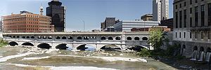 |
 |
Old Erie Canal
Rochester Subway
The Rochester Subway or Rochester Industrial and Rapid Transit Railway was an underground rapid transit line in the city of Rochester, New York from 1927 to 1956. Contemporary photos show it used single streetcars, like Boston's Green Line, as a light rail line, with a large portion underground...
in Rochester. A 36-mile (58 km) stretch of the old canal is preserved by New York State as Old Erie Canal State Historic Park
Old Erie Canal State Historic Park
Old Erie Canal State Historic Park is a part of the New York State Park system. It is a linear park encompassing a 36-mile segment of the original Erie Canal's Long Level section, and extends eastward from Butternut Creek in the town of Dewitt, New York, east of Syracuse, to just outside of the...
. In 1960 the Schoharie Crossing State Historic Site
Schoharie Crossing State Historic Site
Schoharie Crossing State Historic Site, also known as Erie Canal National Historic Landmark, is a historic district that includes the ruins of the Erie Canal aqueduct over Schoharie Creek, and a long part of the Erie Canal, in the towns of Glen and Florida within Montgomery County, New York...
, a section of the canal in Montgomery County
Montgomery County, New York
As of the census of 2000, there were 49,708 people, 20,038 households, and 13,104 families residing in the county. The population density was 123 people per square mile . There were 22,522 housing units at an average density of 56 per square mile...
, was one of the first sites recognized as a National Historic Landmark
National Historic Landmark
A National Historic Landmark is a building, site, structure, object, or district, that is officially recognized by the United States government for its historical significance...
.
Some municipalities have preserved sections as town or county canal parks, or have plans to do so. Camillus Erie Canal Park
Camillus Erie Canal Park
Camillus Erie Canal Park is a town park in Camillus, New York that preserves a seven mile stretch of the Erie Canal. It includes the Nine Mile Creek Aqueduct, which is listed on the National Register of Historic Places...
preserves a 7 miles (11.3 km) stretch and the city plans to restore Nine Mile Creek Aqueduct
Nine Mile Creek Aqueduct
Nine Mile Creek Aqueduct is a restored stone and wood aqueduct of the Erie Canal over Nine Mile Creek in Camillus, New York. It was built in 1841 and was listed on the National Register of Historic Places in 1976....
, built in 1841 as part of the First Enlargement of the canal. In some communities, the old canal has refilled with overgrowth and debris. Proposals have been made to rehydrate the old canal through downtown Rochester or Syracuse as a tourist attraction
Tourist attraction
A tourist attraction is a place of interest where tourists visit, typically for its inherent or exhibited cultural value, historical significance, natural or built beauty, or amusement opportunities....
. In Syracuse, the location of the old canal is represented by a reflecting pool in downtown's Clinton Square and the downtown hosts a canal barge and weigh lock
Weigh lock
A weigh lock is a specialized canal lock designed to determine the weight of barges in order to assess toll payments based upon the weight and value of the cargo carried. This requires that the unladen weight of the barge be known....
structure, now dry. Buffalo's Commercial Slip
Commercial Slip
Buffalo, New York's Commercial Slip is a recently re-excavated and restored portion of the western terminus of the Erie Canal.The Slip was a remnant of Little Buffalo Creek, which flowed into the Buffalo River just before the larger stream entered Lake Erie...
is the recently restored and re-watered segment of the canal which formed its "Western Terminus".
The Erie Canal is a destination for tourists from all over the world. An Erie Canal Cruise company, based in Herkimer, operates from mid-May until mid-October with daily cruises. The cruise goes through the history of the canal and also takes passengers through Lock 18.
In 2004, the administration of New York Governor George Pataki
George Pataki
George Elmer Pataki is an American politician who was the 53rd Governor of New York. A member of the Republican Party, Pataki served three consecutive four-year terms from January 1, 1995 until December 31, 2006.- Early life :...
was criticized when officials of New York State Canal Corporation attempted to sell private development rights to large stretches of the Old Erie Canal to a single developer for US$30,000, far less than the land was worth on the open market. After an investigation by the Syracuse Post-Standard
Syracuse Post-Standard
The Post-Standard is the major daily newspaper servicing the greater Syracuse, New York, metro area. Affiliated with Syracuse.com, it is owned by Advance Publications. The Post-Standard features regular political commentary from Sean Kirst and local commentary by Dick Case. It is home-delivered in...
newspaper, the Pataki administration nullified the deal.
Greenway (landscape)
A greenway is a long, narrow piece of land, often used for recreation and pedestrian and bicycle user traffic, and sometimes for streetcar, light rail or retail uses.- Terminology :...
to attract tourism has been an elusive goal since it was first proposed in the 1990s. But, many communities along the old Erie Canal have made progress in establishing parks, improving towpaths and raising funds for restoration of old canal structures such as locks and aqueducts. Biking, hiking, snowmobiling, cross-country skiing, horseback riding, canoeing and fishing are among activities promoted.
Records of the planning, design, construction and administration of the Erie Canal are vast and can be found in the New York State Archives. Except for two years (1827–1829), the State of New York did not require canal boat operators to maintain or submit passenger lists.
Parks and museums
Parks and museums on the old Erie Canal include (East to West):- Enlarged Erie Canal Historic District (discontiguous)Enlarged Erie Canal Historic District (Discontiguous)Enlarged Erie Canal Historic District is a national historic district located at Cohoes in Albany County, New York. It includes two contributing buildings and 10 contributing structures. It encompasses resources associated with the Enlarged Erie Canal, 1835-1862, Locks 9 through 18, and located...
, a national historic districtHistoric district (United States)In the United States, a historic district is a group of buildings, properties, or sites that have been designated by one of several entities on different levels as historically or architecturally significant. Buildings, structures, objects and sites within a historic district are normally divided...
located at Cohoes, New YorkCohoes, New YorkCohoes is an incorporated city located at the northeast corner of Albany County in the US state of New York. It is called the "Spindle City" because of the importance of textile production to its growth. As of the 2010 census, the city population was 16,168...
listed on the National Register of Historic PlacesNational Register of Historic PlacesThe National Register of Historic Places is the United States government's official list of districts, sites, buildings, structures, and objects deemed worthy of preservation...
in 2004. - Enlarged Double Lock No. 23, Old Erie CanalEnlarged Double Lock No. 23, Old Erie CanalEnlarged Double Lock No. 23, Old Erie Canal is a historic Erie canal lock located at Rotterdam in Schenectady County, New York. It was built in 1841-1842 as part of the First Enlargement. It is built entirely of large cut limestone blocks, laid regular ashlar, and mortared with hydraulic cement...
, Rotterdam, New York - Watervliet Side Cut LocksWatervliet Side Cut LocksWatervliet Side Cut Locks,Photo shows the Watervleit weighlock, not the side cut. the side cut locks were buried a long time ago. see following web page about the Maplewood historic park.http://www.hmdb.org/marker.asp?marker=40996...
, located at Watervliet, New YorkWatervliet, New YorkWatervliet is a city in Albany County in the US state of New York. The population was 10,254 as of the 2010 census. Watervliet is north of Albany, the capital of the state, and is bordered on the north, west, and south by the town of Colonie. The city is also known as "the Arsenal City".- History...
and listed on the National Register of Historic Places in 1971. - Schoharie Crossing State Historic SiteSchoharie Crossing State Historic SiteSchoharie Crossing State Historic Site, also known as Erie Canal National Historic Landmark, is a historic district that includes the ruins of the Erie Canal aqueduct over Schoharie Creek, and a long part of the Erie Canal, in the towns of Glen and Florida within Montgomery County, New York...
at Fort HunterFort Hunter, New YorkFort Hunter is a hamlet in the town of Florida in Montgomery County, New York, on the Mohawk River at Schoharie Creek.In the 18th century, Fort Hunter was built as a fort near the location of one of the two primary Mohawk settlements. The Mohawk name for the village was rendered variously in... - Erie Canal Village, near Rome
- Chittenango Landing Canal Boat Museum near ChittenangoChittenango, New YorkChittenango is a village located in Madison County, New York, in the United States. The village is in the south part of the Town of Sullivan. The population was 5,081 at the 2010 census.- History :...
- Old Erie Canal State Historic ParkOld Erie Canal State Historic ParkOld Erie Canal State Historic Park is a part of the New York State Park system. It is a linear park encompassing a 36-mile segment of the original Erie Canal's Long Level section, and extends eastward from Butternut Creek in the town of Dewitt, New York, east of Syracuse, to just outside of the...
in Dewitt - Erie Canal MuseumErie Canal MuseumThe Erie Canal Museum, in Syracuse, New York is a museum about the Erie Canal across New York. It is located in the Weighlock Building, itself listed on the National Register of Historic Places of the United States....
in downtown Syracuse - Camillus Erie Canal ParkCamillus Erie Canal ParkCamillus Erie Canal Park is a town park in Camillus, New York that preserves a seven mile stretch of the Erie Canal. It includes the Nine Mile Creek Aqueduct, which is listed on the National Register of Historic Places...
in CamillusCamillus, New YorkCamillus, New York is located in Onondaga County. There are two parts to Camillus, New York:*Camillus, New York *Camillus, New York... - Jordan Canal ParkJordan Canal ParkJordan Canal Park in Jordan, New York includes the Jordan Aqueduct, which carried the Erie Canal over Skaneateles Creek.There is a pathway along the canal through the village....
in JordanJordan, New YorkJordan is a village in Onondaga County, New York, United States. The population was 1,314 at the 2000 census. It is part of the Syracuse Metropolitan Statistical Area....
, town of ElbridgeElbridge (town), New YorkElbridge is a town in Onondaga County, New York, United States. The population was 6,091 at the 2000 census. The town is named after Elbridge Gerry, a Vice President of the United States, and one of the signers of the Declaration of Independence.... - Enlarged Double Lock No. 33 Old Erie CanalEnlarged Double Lock No. 33 Old Erie CanalEnlarged Double Lock No. 33 Old Erie Canal is a historic Erie canal lock located at St. Johnsville in Montgomery County, New York. It was built in 1824 and enlarged in 1840. The south lock was enlarged in 1888. It is built entirely of large cut limestone blocks mortared with hydraulic cement. ...
, St. Johnsville, New YorkSt. Johnsville (village), New YorkSt. Johnsville is a village in Montgomery County, New York, United States. The population was 1,685 at the 2000 census. The name is derived from Alexander St. John, an early surveyor and commissioner.... - Erie Canal Lock 52 ComplexErie Canal Lock 52 ComplexErie Canal Lock 52 Complex is a national historic district located at Port Byron and Mentz in Cayuga County, New York. The district includes two contributing buildings ; three contributing engineering structures ; and archaeological sites associated with the canal...
, a national historic district located at Port ByronPort Byron, New YorkPort Byron is a village in Cayuga County, New York, United States. The population was 1,297 at the 2000 census. The village is believed to be named after Lord Byron.The Village of Port Byron is in the Town of Mentz and is north of Auburn, New York....
and MentzMentz, New YorkMentz is a town in Cayuga County, New York, United States. The population was 2,378 at the 2010 census.The Town of Mentz is on the central part of the county, north of Auburn, New York.- History :...
in Cayuga CountyCayuga County, New YorkCayuga County is a county located in the U.S. state of New York. It was named for one of the tribes of Indians in the Iroquois Confederation. Its county seat is Auburn.- History :...
; listed on the National Register of Historic Places in 1998. - Seneca River Crossing Canals Historic DistrictSeneca River Crossing Canals Historic DistrictSeneca River Crossing Canals Historic District is a national historic district located at Montezuma and Tyre in Cayuga County, New York. The district includes more than a mile of the Enlarged Erie Canal prism ; towpath and heelpath; a drydock; the remains of the Richmond Aqueduct crossing the...
, a national historic district located at MontezumaMontezuma, New YorkMontezuma is a town in Cayuga County, New York, United States. The population was 1,277 at the 2010 census.The Town of Montezuma is at the west border of Cayuga County and is northwest of Auburn, New York.- History :...
and TyreTyre, New YorkTyre is a town in Seneca County, New York, United States. The population was 899 at the 2000 census. The town is named after the Lebanese city of Tyre.The Town of Tyre is located in the northeastern part of the county, northeast of Geneva, New York....
in Cayuga County; listed on the National Register of Historic Places in 2005. - Centerport Aqueduct ParkCentreport AqueductCentreport Aqueduct is a historic aqueduct located in the town of Brutus near Weedsport in Cayuga County, New York. The aqueduct was consrtructed in 1854-1857 as a part of the Weedsport section of the "Improved Erie Canal." The wood and stone aqueduct carried the Erie Canal over Cold Spring Brook...
near WeedsportWeedsport, New YorkWeedsport is a village in Cayuga County, New York, USA. The population was 2,017 at the 2000 census. The name is from Elihu and Edward Weed, merchants who helped found the village....
; listed on the National Register of Historic Places in 2000. - Lock Berlin Park near ClydeClyde, New YorkClyde is a village in Wayne County, New York, United States. The population was 2,269 at the 2000 census.The Village of Clyde is in the Town of Galen and is northeast of Geneva, NY...
- Macedon Aqueduct Park near PalmyraPalmyra (town), New YorkPalmyra is a town in Wayne County, New York, USA. The population was 7,672 at the 2000 census. The town is named after the ancient city Palmyra in Syria....
- Old Erie Canal Lock 60 Park in MacedonMacedon (town), New YorkMacedon is a town in Wayne County, New York, United States. The population was 9,148 at the 2010 census. The town is named after the ancient Macedonian Kingdom of Macedon, the birthplace of Alexander the Great....
- Perinton Park in Perinton near FairportFairport, New YorkFairport is a village located in the town of Perinton which is part of Monroe County, New York. Fairport is a suburb east of Rochester. It is also known as the "Crown Jewel of the Erie Canal"...
- Genesee Valley ParkGenesee Valley ParkGenesee Valley Park is located in the south side of Rochester, New York along the shores of the Genesee River. The New York State Barge Canal crosses the Genesee River within the park...
near the city of Rochester - Niagara Escarpment five flight locks at Lockport
- Buffalo's Commercial SlipCommercial SlipBuffalo, New York's Commercial Slip is a recently re-excavated and restored portion of the western terminus of the Erie Canal.The Slip was a remnant of Little Buffalo Creek, which flowed into the Buffalo River just before the larger stream entered Lake Erie...
at the Canal's "Western Terminus" - The Day PeckinpaughDay Peckinpaugh (canal motorship)Day Peckinpaugh is a historic canal motorship currently berthed at the Matton Shipyard on Peebles Island, Cohoes in Albany County, New York.-Early Years:...
ship, currently under restoration and conversion to a floating Museum, planned for completion in 2012
Locks
The following list of locksLock (water transport)
A lock is a device for raising and lowering boats between stretches of water of different levels on river and canal waterways. The distinguishing feature of a lock is a fixed chamber in which the water level can be varied; whereas in a caisson lock, a boat lift, or on a canal inclined plane, it is...
is provided for the current canal, from east to west:
Note: There is no Lock 1 or Lock 31 on the Erie Canal. The place of "Lock 1" on the passage from the lower Hudson to Lake Erie is taken by the Federal Lock, located just north of Troy, NY, and is not part of the Erie Canal System proper.
| Lock # | Location | Elevation (upstream/west) |
Elevation (downstream/east) |
Lift | Distance to Next Lock (upstream/west) |
|---|---|---|---|---|---|
| 2 | Waterford | 48.9 ft (14.9 m) | 15.3 ft (4.7 m) | 33.6 ft (10.2 m) | E3, 0.28 mi (0.4506152 km) |
| 3 | Waterford | 83.5 ft (25.5 m) | 48.9 ft (14.9 m) | 34.6 ft (10.5 m) | E4, 0.62 mi (0.9977908 km) |
| 4 | Waterford | 118.1 ft (36 m) | 83.5 ft (25.5 m) | 34.6 ft (10.5 m) | E5, 0.16 mi (0.2574944 km) |
| 5 | Waterford | 151.4 ft (46.1 m) | 118.1 ft (36 m) | 33.3 ft (10.1 m) | E6, 0.28 mi (0.4506152 km) |
| 6 | Waterford | 184.4 ft (56.2 m) | 151.4 ft (46.1 m) | 33 ft (10.1 m) | E7, 10.83 mi (17.4 km) |
| 7 | Niskayuna | 211.4 ft (64.4 m) | 184.4 ft (56.2 m) | 27 ft (8.2 m) | E8, 10.83 mi (17.4 km) |
| 8 | Glenville Glenville, Schenectady County, New York Glenville is a town in Schenectady County, New York, United States. It was incorporated in 1821. As of the 2000 census, the town population was 28,183.... |
225.4 ft (68.7 m) | 211.4 ft (64.4 m) | 14 ft (4.3 m) | E9, 4.82 mi (7.8 km) |
| 9 | Rotterdam Rotterdam (town), New York Rotterdam is a town in Schenectady County, New York, United States. The population was 28,316 at the 2000 census.The town of Rotterdam is in the south-central part of the county. It was founded by Dutch settlers, who named it after the port of Rotterdam in the Netherlands, where many emigrants last... |
240.4 ft (73.3 m) | 225.4 ft (68.7 m) | 15 ft (4.6 m) | E10, 6.16 mi (9.9 km) |
| 10 | Cranesville | 255.4 ft (77.8 m) | 240.4 ft (73.3 m) | 15 ft (4.6 m) | E11, 4.05 mi (6.5 km) |
| 11 | Amsterdam | 267.4 ft (81.5 m) | 255.4 ft (77.8 m) | 12 ft (3.7 m) | E12, 4.57 mi (7.4 km) |
| 12 | Tribes Hill Tribes Hill, New York Tribes Hill is a census-designated place located in the Towns of Mohawk and Amsterdam in Montgomery County, New York, United States. The population was 1,024 at the 2000 census... |
278.4 ft (84.9 m) | 267.4 ft (81.5 m) | 11 ft (3.4 m) | E13, 9.68 mi (15.6 km) |
| 13 | Randall | 286.4 ft (87.3 m) | 278.4 ft (84.9 m) | 8 ft (2.4 m) | E14, 7.9 mi (12.7 km) |
| 14 | Canajoharie Canajoharie, New York Canajoharie, New York may refer to:* Canajoharie , New York* Canajoharie , New York... |
294.4 ft (89.7 m) | 286.4 ft (87.3 m) | 8 ft (2.4 m) | E15, data unavailable |
| 15 | Fort Plain Fort Plain, New York Fort Plain is a village in Montgomery County, New York, United States. As of the 2000 census, the village population was 2,288. The village is named after a fort built during the American Revolution.... |
302.4 ft (92.2 m) | 294.4 ft (89.7 m) | 8 ft (2.4 m) | E16, data unavailable |
| 16 | Mindenville Minden, New York Minden is a town in Montgomery County, New York, United States. The population was 4,297 at the 2010 census. The town is located at the western edge of the county. It has possessed a post office from 1802 to 1903.- History :... |
322.9 ft (98.4 m) | 302.4 ft (92.2 m) | 20.5 ft (6.2 m) | E17, data unavailable |
| 17 | Little Falls | 363.4 ft (110.8 m) | 322.9 ft (98.4 m) | 40.5 ft (12.3 m) | E18, data unavailable |
| 18 | Jacksonburg | 383.4 ft (116.9 m) | 363.4 ft (110.8 m) | 20 ft (6.1 m) | E19, data unavailable |
| 19 | Frankfort Frankfort (town), New York Frankfort is a town in Herkimer County, New York, United States. The population was 7,478 at the 2000 census. The town is named after one of its earliest settlers, Lawrence Frank. The town of Frankfort includes a village also called Frankfort. The town is east of Utica... |
404.4 ft (123.3 m) | 383.4 ft (116.9 m) | 21 ft (6.4 m) | E20, data unavailable |
| 20 | Careys Corners Marcy, New York Marcy is a town in Oneida County, New York, United States. The population was 9,469 at the 2000 census. The town was named after Governor William L. Marcy.... |
420.4 ft (128.1 m) | 404.4 ft (123.3 m) | 16 ft (4.9 m) | E21, data unavailable |
| 21 | Rome Rome, New York Rome is a city in Oneida County, New York, United States. It is located in north-central or "upstate" New York. The population was 44,797 at the 2010 census. It is in New York's 24th congressional district. In 1758, British forces began construction of Fort Stanwix at this strategic location, but... |
395.4 ft (120.5 m) | 420.4 ft (128.1 m) | 25 ft (7.6 m) | E22, data unavailable |
| 22 | Rome Rome, New York Rome is a city in Oneida County, New York, United States. It is located in north-central or "upstate" New York. The population was 44,797 at the 2010 census. It is in New York's 24th congressional district. In 1758, British forces began construction of Fort Stanwix at this strategic location, but... |
370.1 ft (112.8 m) | 344.8 ft (105.1 m) | 25.3 ft (7.7 m) | E23, data unavailable |
| 23 | Brewerton Brewerton, New York Brewerton is a census-designated place in the town of Cicero in Onondaga County and the town of Hastings in Oswego County in the U.S. state of New York. It lies at the west end of Oneida Lake at its outlet into the Oneida River. The population was 3,455 at the 2000 census... |
363 ft (110.6 m) | 370.1 ft (112.8 m) | 7.1 ft (2.2 m) | E24, data unavailable |
| 24 | Baldwinsville Baldwinsville, New York Baldwinsville is a village in Onondaga County, New York, United States. The population was 7,053 at the 2000 census. It is part of the Syracuse Metropolitan Statistical Area.... |
374 ft (114 m) | 363 ft (110.6 m) | 11 ft (3.4 m) | E25, 30.75 mi (49.5 km) |
| 25 | Mays Point | 380 ft (115.8 m) | 374 ft (114 m) | 6 ft (1.8 m) | E26, 5.84 mi (9.4 km) |
| 26 | Clyde Clyde, New York Clyde is a village in Wayne County, New York, United States. The population was 2,269 at the 2000 census.The Village of Clyde is in the Town of Galen and is northeast of Geneva, NY... |
386 ft (117.7 m) | 380 ft (115.8 m) | 6 ft (1.8 m) | E27, 12.06 mi (19.4 km) |
| 27 | Lyons Lyons (town), New York Lyons is a town in Wayne County, New York, USA. The population was 5,831 at the 2000 census. The town is named after Lyons , France.... |
398.5 ft (121.5 m) | 386 ft (117.7 m) | 12.5 ft (3.8 m) | E28A, 1.25 mi (2 km) |
| 28A | Lyons Lyons (town), New York Lyons is a town in Wayne County, New York, USA. The population was 5,831 at the 2000 census. The town is named after Lyons , France.... |
418 ft (127.4 m) | 398.5 ft (121.5 m) | 19.5 ft (5.9 m) | E28B, 3.93 mi (6.3 km) |
| 28B | Newark Newark, New York Newark is a village in Wayne County, New York, U.S., south east of Rochester. The population was 9,682 at the 2000 census.The Village of Newark is in the south part of the Town of Arcadia and is in the south of Wayne County.- History :... |
430 ft (131.1 m) | 418 ft (127.4 m) | 12 ft (3.7 m) | E29, 9.7 mi (15.6 km) |
| 29 | Palmyra Palmyra (town), New York Palmyra is a town in Wayne County, New York, USA. The population was 7,672 at the 2000 census. The town is named after the ancient city Palmyra in Syria.... |
446 ft (135.9 m) | 430 ft (131.1 m) | 16 ft (4.9 m) | E30, 3 mi (4.8 km) |
| 30 | Macedon Macedon (town), New York Macedon is a town in Wayne County, New York, United States. The population was 9,148 at the 2010 census. The town is named after the ancient Macedonian Kingdom of Macedon, the birthplace of Alexander the Great.... |
462.4 ft (140.9 m) | 446 ft (135.9 m) | 16.4 ft (5 m) | E32, 16.1 mi (25.9 km) |
| 32 | Pittsford Pittsford (town), New York Pittsford is a town in Monroe County, New York, United States and is an affluent suburb of Rochester. The population was 29,405 at the 2010 census.... |
487.5 ft (148.6 m) | 462.4 ft (140.9 m) | 25.1 ft (7.7 m) | E33, 1.3 mi (2.1 km) |
| 33 | Henrietta Henrietta, New York Henrietta is a town in Monroe County, New York, United States. It is a suburb of Rochester. The population was 42,581 at the 2010 census. Established in 1818, the town is named after Henrietta Laura Pulteney, Countess of Bath, daughter of Sir William Pulteney, 5th Baronet, a major British... |
512.9 ft (156.3 m) | 487.5 ft (148.6 m) | 25.4 ft (7.7 m) | E34/35, 64.2 mi (103.3 km) |
| 34 | Lockport Lockport (city), New York Lockport is a city in Niagara County, New York, United States. The population was 21,165 at the 2010 census. The name is derived from a set of Erie canal locks within the city. Lockport is the county seat of Niagara County and is surrounded by the town of Lockport... |
539.5 ft (164.4 m) | 514.9 ft (156.9 m) |
24.6 ft (7.5 m) | E35, 0 mi (0 km) |
| 35 | Lockport Lockport (city), New York Lockport is a city in Niagara County, New York, United States. The population was 21,165 at the 2010 census. The name is derived from a set of Erie canal locks within the city. Lockport is the county seat of Niagara County and is surrounded by the town of Lockport... |
564 ft (171.9 m) | 539.5 ft (164.4 m) | 24.5 ft (7.5 m) | Black Rock Lock in Niagara River Niagara River The Niagara River flows north from Lake Erie to Lake Ontario. It forms part of the border between the Province of Ontario in Canada and New York State in the United States. There are differing theories as to the origin of the name of the river... , 26 mi (41.8 km) |
| 36* | Buffalo Buffalo, New York Buffalo is the second most populous city in the state of New York, after New York City. Located in Western New York on the eastern shores of Lake Erie and at the head of the Niagara River across from Fort Erie, Ontario, Buffalo is the seat of Erie County and the principal city of the... |
571 ft (174 m) | 566 ft (172.5 m) | 5 ft (1.5 m) | Commercial Slip Commercial Slip Buffalo, New York's Commercial Slip is a recently re-excavated and restored portion of the western terminus of the Erie Canal.The Slip was a remnant of Little Buffalo Creek, which flowed into the Buffalo River just before the larger stream entered Lake Erie... at Buffalo River Buffalo River (New York) The Buffalo River is a river that empties into the eastern end of Lake Erie, one of the Great Lakes, by the City of Buffalo in the United States of America. This stream is called the Buffalo River only in the vicinity of the city and is known as Buffalo Creek as it flows through other parts of... , 4 mi (6.4 km) |
*Note: The Black Rock Lock
Black Rock Lock
The Black Rock Lock located in Buffalo, New York is in length and in wide. There is only one chamber and the total weight of the gate is 480 tons. The lock has been a part of Black Rock since the state of New York built the Erie Canal in 1833....
is in the New York State Barge Canal, and allows passage beside the Niagara River to the Erie Canal's "Western Terminus" at the Commercial Slip
Commercial Slip
Buffalo, New York's Commercial Slip is a recently re-excavated and restored portion of the western terminus of the Erie Canal.The Slip was a remnant of Little Buffalo Creek, which flowed into the Buffalo River just before the larger stream entered Lake Erie...
. Upstream and downstream water levels, as well as Black Rock Lock's lift, vary with the naturally fluctuating levels of Lake Erie and the Niagara River. Although a portion of the Erie Canal through Buffalo has been filled in, travel by water is still possible, from the Commercial Slip, through Buffalo's Inner Harbor and the Black Rock Lock, to Tonawanda, NY
Tonawanda (town), New York
Tonawanda is a town in Erie County, New York, United States. As of the 2000 census, the town had a population of 78,155. The town is at the north border of the county and is the northern suburb of Buffalo...
, Lockport, and eastward to Albany.
See also
- BoatmanBoatman-Insects:* Lesser water boatman, a water-dwelling insect* Water boatman , types of insect-People named Boatman:* Barny Boatman , English professional poker player* Michael Boatman , American actor...
- Alfred BarrettAlfred BarrettAlfred Barrett was born in New England. He was an engineer by training.In about 1818, Barrett began working on the engineering staff that was constructing the Erie Canal in New York State. He rapidly gained experience and was an accredited engineer by 1821...
- Canal Street (Buffalo)Canal Street (Buffalo)Canal Street was the name of a thoroughfare as well as a district in Buffalo in the nineteenth and early twentieth centuries. Originally called Rock Street, Canal Street ran parallel to and just to the west of the famed Erie Canal at its western terminus in Buffalo. The area had been the site of...
- Low Bridge (song)Low Bridge (song)The popular song "Fifteen Miles on the Erie Canal" was written in 1905 by Thomas S. Allen after Erie Canal barge traffic was converted from mule power to engine power, raising the speed of traffic above fifteen miles per day. The tune is sadly nostalgic...
- Illinois and Michigan CanalIllinois and Michigan CanalThe Illinois and Michigan Canal ran from the Bridgeport neighborhood in Chicago on the Chicago River to LaSalle-Peru, Illinois, on the Illinois River. It was finished in 1848 when Chicago Mayor James Hutchinson Woodworth presided over its opening; and it allowed boat transportation from the Great...
, connecting Lake MichiganLake MichiganLake Michigan is one of the five Great Lakes of North America and the only one located entirely within the United States. It is the second largest of the Great Lakes by volume and the third largest by surface area, after Lake Superior and Lake Huron...
with the Mississippi River - Ohio and Erie CanalOhio and Erie CanalThe Ohio Canal or Ohio and Erie Canal was a canal constructed in the 1820s and early 1830s. It connected Akron, Summit County, with the Cuyahoga River near its mouth on Lake Erie in Cleveland, Cuyahoga County, and a few years later, with the Ohio River near Portsmouth, Scioto County, and then...
, connecting Lake ErieLake ErieLake Erie is the fourth largest lake of the five Great Lakes in North America, and the tenth largest globally. It is the southernmost, shallowest, and smallest by volume of the Great Lakes and therefore also has the shortest average water residence time. It is bounded on the north by the...
with the Ohio RiverOhio RiverThe Ohio River is the largest tributary, by volume, of the Mississippi River. At the confluence, the Ohio is even bigger than the Mississippi and, thus, is hydrologically the main stream of the whole river system, including the Allegheny River further upstream...
, and thus the Mississippi RiverMississippi RiverThe Mississippi River is the largest river system in North America. Flowing entirely in the United States, this river rises in western Minnesota and meanders slowly southwards for to the Mississippi River Delta at the Gulf of Mexico. With its many tributaries, the Mississippi's watershed drains... - List of canals in New York
- List of canals in the United States
External links
- Information and Boater's Guide to the Erie Canal
- Canalway Trail Information
- Historical information (with photos) of the Erie Canal
- New York State Canal Corporation Site
- The Opening of the Erie Canal - An Online Exhibition by CUNY
- The Canal Society of New York State
- Digging Clinton's Ditch: The Impact of the Erie Canal on America 1807-1860 Multimedia
- A Glimpse at Clinton's Ditch, 1819-1820 by Richard F. Palmer
- Guide to Canal Records in the New York State Archives
Images and maps
- Photos of historic Erie Canal Structures
- Photos of historic Erie Canal Locks
- Photos of some Erie Canal Aqueducts
- http://maps.google.com/maps?f=d&source=s_d&saddr=albany,ny&daddr=6th+St+to:Riverview+Rd+to:Riverview+Rd+to:Balltown+Rd%2FNY-146+to:Mohawk+Turnpike%2FNY-5+to:Mohawk+Turnpike%2FNY-5%2FUS-5+to:NY-5%2FState+Route+5+to:Rome,+NY+to:Canastota,+NY+to:syracuse,ny+to:Columbia+St+to:NY-31+W%2FState+Route+31+W+to:NY-31%2FSpencerport+Rd+to:NY-31%2FSpencerport+Rd+to:Canal+Rd+to:East+Ave+to:NY-31%2FState+Route+31+to:NY-31%2FTelegraph+Rd+to:lockport,+ny+to:Pendleton,+New+York+to:Tonawanda+,+NY+to:waterfront+buffalo,+ny&hl=en&geocode=%3BFXb1jAId1Leb-w%3BFTAGjQId7xGa-w%3BFSWhjQIdcc6Y-w%3BFfLXjQIdPI-Y-w%3BFYnkjgIdPbWU-w%3BFTRPjwIdwsKQ-w%3BFWWBkAIdTkqJ-w%3B%3B%3B%3BFZxrkQIdjPRq-w%3BFb7gkAIdfBJn-w%3BFU69kgIdVkFe-w%3BFdDQkgIdRLpd-w%3BFfcekwIdWJlc-w%3BFZ97kwId6ENb-w%3BFQzSkwIdGaFX-w%3BFWCgkwIdmJVU-w%3B%3B%3B%3B&mra=mr&mrcr=1&via=1,2,3,4,5,6,7,11,12,13,14,15,16,17,18&sll=43.216311,-75.49118&sspn=0.055358,0.119219&ie=UTF8&ll=42.767179,-76.234131&spn=3.568683,7.630005&z=8Approximate route of the Erie Canal on Google Maps]
Parks and museums