
.gif)
Interstate 290 (Illinois)
Encyclopedia
Interstate 290 is a main Interstate freeway that runs westwards from the Chicago Loop
. A portion of I-290 is officially called the Dwight D. Eisenhower Expressway. In short form, it is known as "the Ike" or the Eisenhower. Before being designated the Eisenhower Expressway, the highway was called the Congress Expressway because of the surface street that was located approximately in its path and onto which I - 290 runs at its eastern terminus in the Chicago Loop
.
Interstate 290 connects Interstate 90
(the Jane Addams Memorial Tollway) in Rolling Meadows, Illinois
with Interstate 90/Interstate 94
(the John F. Kennedy Expressway
/ Dan Ryan Expressway
) near the Loop. North of Interstate 355
, the freeway is sometimes known locally as Illinois Route 53
, or simply Route 53, since Illinois 53 existed before Interstate 290. However, it now merges with I-290 at Biesterfield Road. In total, Interstate 290 is 29.84 miles (48.02 km) long.
. It is the portion of I-290 more locally known as "Route 53." Here, Interstate 290 runs largely above-grade through Schaumburg, Illinois
and Elk Grove Village, and at-or-below grade through Itasca and Addison.
The northern five miles (eight km) of this highway were reconstructed in 2003-2004. A left shoulder and an auxiliary lane between ramps were added, as well as improved lighting. The highway is four lanes wide (not counting the auxiliary lane) north of the Elgin-O'Hare Expressway / Thorndale Avenue (mile marker 5), and five lanes wide with a wide left shoulder south to the exit to Interstate 355.
Between mile markers zero and four, Illinois Route 53
overlaps this section of the Eisenhower Expressway.
. It took its name when the Eisenhower was extended northwest from Hillside. The highway runs largely at-grade or above-grade for this length. U.S. Route 20
on overlaps I-290 around Elmhurst
from mile markers 12 to 13, and runs parallel to the rest of this section between mile markers seven and 18.
This section of I-290 varies in width from two lanes at the ramp east from the I-290/I-355 split, to three lanes between I-355 and U.S. Route 20
, to three lanes plus two exit lanes at U.S. Route 20/Illinois Route 64 (Lake Street / North Avenue) (exit 13B). After exit 13B, the highway reverts to three thru traffic lanes. Exit 15 to southbound Interstate 294 is a frequent point of congestion due to ramp traffic backing up onto the mainline highway, often as long as two miles (3 km). This is because the ramp is not isolated from the mainline, only one lane in width, is a low-speed ramp (marked as a 35 mi/h ramp, and is relatively short (1/4 mile, or 1/2 km) while carrying a high volume of truck traffic south to Indiana from North Avenue. Additionally, the sudden appearance of the exit tends to cause accidents when cars in the center lane try to aggressively turn into the right lane, particularly at the mouth of the I-294 exit. Finally, there is a dangerous high-volume weaving situation at the end of the ramp to I-294 with southbound I-294 traffic exiting to westbound Interstate 88
. As of 2006, there are no plans to overcome any of these problems with new construction.
 The western three miles (5 km) of this section are blacktop, while east of Illinois Route 83
(exit 10) the original concrete is still in place.
and the Chicago Skyway
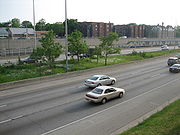
. It is known for having a high volume of traffic on ramps through the Avenues, and high volumes of traffic on left-side ramps in Forest Park and Oak Park. Interstate 290 runs above grade west of Mannheim Road, and at or below grade east of Mannheim Road.
Eastbound at Mannheim Road (exit 17), the highway splits into two express and one local lane; they are joined by two onramps from Interstate 88
and form express lanes three lanes wide and local lanes to Mannheim Road two lanes wide. After Mannheim Road, the highway immediately narrows to three lanes in width, causing mile-long (1.6 km) backups. It remains three lanes to Austin Boulevard. Westbound, I-290 merely is three lanes wide to Mannheim Road, and then four lanes wide to the I-88/I-290 split. Exits at Harlem Avenue (exit 21B) and Austin Boulevard (exit 23) are left offramps and onramps, causing backups as trucks switch lanes to exit, and a large volume of traffic enters on the left side of the highway.
In 2001–2002, this section between mile markers 15 and 18 was reconstructed in the first phase of an attempt to untangle the "Hillside Strangler", adding the local lanes and extra on-ramp to Interstate 290. The second phase, reconstruction of the highway between mile markers 18 and 23 (Mannheim Road to Austin Boulevard), is still in the preliminary engineering phase of construction as of April 2009.
 The easternmost section of I-290 is 7 miles (11 km) long and runs entirely through the city of Chicago to the terminus at Interstate 90/94. It runs below grade for its entire length.
This highway is four lanes wide in both directions for its entire length, and most on-ramps and off-ramps are located just two blocks apart. Therefore, an exit in one direction may be marked one street (ex. Laramie Avenue), while the same exit in the other direction may be marked another (ex. Cicero Avenue), even though the streets are only a block apart. This configuration results in most exits on this portion of road being marked as A/B exits.
Eastbound congestion is lighter here than through the "Avenues", generally limited to congestion on the tight onramps to the John F. Kennedy and Dan Ryan Expressways (the Circle Interchange) at the eastern terminus or a blind onramp at Kostner Avenue. Westbound, congestion is heavy starting at Laramie due to the left-hand exit at Austin (which combines a "perfect storm" of a four-down-to-three lane reduction, an unfamiliar left-hand exit, and entrance and in-merging traffic of the central onramp). Most afternoons, this bottleneck can skyrocket the "Post Office to Wolf (Road)" commute time to over an hour (up from 16 mins with no traffic).
The Eisenhower Expressway runs along blacktop pavement for the length of the section, except between Kostner Avenue and Independence Boulevard, where it runs on concrete pavement.
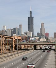
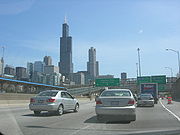
The eastern terminus of I-290 is the Circle Interchange
with I-90/I-94. After this junction, the route becomes an elevated and continues as a highway until LaSalle Street
, at which point it passes under LaSalle Street Station
and comes out the other side as a city street (Congress Parkway). The Congress Parkway route continues east until the street is stopped by Buckingham Fountain
.
 The Chicago Transit Authority
maintains a rail line
from the loop west to Forest Park
that enters the median of the Eisenhower near Halsted Street and stays within the median through the Cicero
station. After Cicero, the line leaves the median and closely parallels the Eisenhower for the rest of its route. While convenient for mass transit, it has also severely limited any possibility of lane additions to the Eisenhower where the train line is. Preliminary studies on such an effort are already starting, however.
's plan of 1909, which described a west side boulevard
. The passageway under the old Post Office was designed to preserve the right of way for the future road.
The Expressway is named for the former President Dwight D. Eisenhower
, and it originally called the Congress Expressway (It begins on Congress Parkway). The political columnist Mike Royko
joked that it is Chicago's only Republican expressway, since the others all named after Democrats (though since that observation Bishop Louis Henry Ford, a non-political figure, had an expressway named in his honor). The first segment, 2.5 miles (4.0 km) in length opened from Mannheim Road to 1st Avenue
in December 1955. On December 15th, 4 additional miles (6 km) opened, from Ashland Avenue (1600 West) to Laramie Avenue (5200 West).
During the 1960s and 1970s, the Eisenhower Expressway was extended to Lake Street
and North Avenue
. In 1963, the first working example of ramp meter
ing took place on the Eisenhower Expressway, based on successful metering through New York City
tunnels and data from ramp closures in Detroit, Michigan
. The first implementation utilized a police officer at the top of an entrance ramp, stopping and releasing vehicles onto the highway at a predetermined rate. Another section opened in 1972, to a north–south expressway in Addison, Illinois
. At the time, this expressway was a short spur from the Eisenhower Expressway, and it was referred to as Illinois Route 53
, which continued north to Schaumburg. Construction on Illinois 53 had finished in 1970.
Until 1978, the Eisenhower Expressway was marked as a part of Interstate 90. In 1978, the Interstate 90 designation was moved onto the John F. Kennedy Expressway and the Northwest Tollway
, replacing Illinois Route 194. The Eisenhower Expressway was then renumbered as Interstate 290.
Because the segment from Interstate 294 to Illinois 53 was built last, that portion of the highway is referred to as the Eisenhower Extension. The Eisenhower Expressway, extension included, is 23 miles (37 km) long. If the Illinois 53 portion of Interstate 290 is added to that, the highway is actually 30 miles (48 km) long.
In 2003-2004, the first five miles (8 km) of Interstate 290 out of Schaumburg
were rebuilt, replacing pavement that had well-exceeded its estimated 20 year lifetime. (The original pavement was built in stages from 1963 through 1970 as part of Illinois 53.) A fifth auxiliary lane was added between the entrance and exit ramps of exits 1, 4 and 5. The most important safety upgrade was the demolition of the raised grassy median between the westbound and eastbound lanes, and its replacement with a permanent concrete median and wide shoulders.
This large building was used by the United States Postal Service
until 1996. The building itself was built from 1921 to 1933 in the Art-Deco style, and it is 2.5 million square feet (230,000 m²) in size. The building, built several decades before the expressway that passes through it, was originally designed to accommodate a roadway - requiring only minimal work to remove walls in the base for the freeway to pass through. In spite of its unused state, the building is still known to visitors and commuters alike as the unofficial gateway into the Chicago Loop area. In late August, 2009, The United States Postal Service announced an auction was to be held to sell the facility to the highest bidder. The winning bid ($40 million) was from an English real estate developer, Bill Davies http://www.nbcchicago.com/news/local-beat/Post-Office-Buyer-May-Not-Deliver-58048172.html.
Chicago Loop
The Loop or Chicago Loop is one of 77 officially designated Chicago community areas located in the City of Chicago, Illinois. It is the historic commercial center of downtown Chicago...
. A portion of I-290 is officially called the Dwight D. Eisenhower Expressway. In short form, it is known as "the Ike" or the Eisenhower. Before being designated the Eisenhower Expressway, the highway was called the Congress Expressway because of the surface street that was located approximately in its path and onto which I - 290 runs at its eastern terminus in the Chicago Loop
Chicago Loop
The Loop or Chicago Loop is one of 77 officially designated Chicago community areas located in the City of Chicago, Illinois. It is the historic commercial center of downtown Chicago...
.
Interstate 290 connects Interstate 90
Interstate 90
Interstate 90 is the longest Interstate Highway in the United States at . It is the northernmost coast-to-coast interstate, and parallels US 20 for the most part. Its western terminus is in Seattle, at Edgar Martinez Drive S. near Safeco Field and CenturyLink Field, and its eastern terminus is in...
(the Jane Addams Memorial Tollway) in Rolling Meadows, Illinois
Rolling Meadows, Illinois
Rolling Meadows is a city in Cook County, Illinois, United States. The population was 24,607 at the 2000 census.-Geography:Rolling Meadows is located at ....
with Interstate 90/Interstate 94
Interstate 94
Interstate 94 is the northernmost east–west Interstate Highway, connecting the Great Lakes and Intermountain regions of the United States. I-94's western terminus is in Billings, Montana at a junction with Interstate 90; its eastern terminus is the U.S...
(the John F. Kennedy Expressway
Kennedy Expressway
The John F. Kennedy Expressway is a long highway that travels northwest from the Chicago Loop to O'Hare International Airport. The expressway is named for the 35th U.S. President, John F. Kennedy. The Interstate 90 portion of the Kennedy is a part of the much longer I-90...
/ Dan Ryan Expressway
Dan Ryan Expressway
The Dan Ryan is an expressway in the city of Chicago that runs from the Circle Interchange with I-290 near downtown Chicago through the South Side of the city. It is designated as both Interstate 94 and Interstate 90 south to 66th Street, a distance of...
) near the Loop. North of Interstate 355
Interstate 355
Interstate 355 , also known as the Veterans Memorial Tollway, is an Interstate Highway and tollway in the western and southwest suburbs of Chicago, Illinois, U.S. Like most other toll roads in the northeastern portion of the state, I-355 is maintained by a State Highway Authority...
, the freeway is sometimes known locally as Illinois Route 53
Illinois Route 53
Illinois Route 53 is an arterial north–south state highway in northeast Illinois. Route 53 runs south from Long Grove at Illinois Route 83 to Gardner at Interstate 55 west of old U.S. Highway 66, a distance of...
, or simply Route 53, since Illinois 53 existed before Interstate 290. However, it now merges with I-290 at Biesterfield Road. In total, Interstate 290 is 29.84 miles (48.02 km) long.
Jane Addams Memorial Tollway to Veterans Memorial Tollway
This section is 7 miles (11 km) long and runs from Rolling Meadows to AddisonAddison, Illinois
Addison is a village located west of the Chicago Metropolitan Area, in DuPage County, Illinois, United States. The population was 35,914 at the 2000 census. The estimated population was 36,378 as of 2002.The Village of Addison lies on Salt Creek...
. It is the portion of I-290 more locally known as "Route 53." Here, Interstate 290 runs largely above-grade through Schaumburg, Illinois
Schaumburg, Illinois
Schaumburg is a city located in Cook County in northeastern Illinois. A common misspelling of the city name is Schaumberg, a spelling which persists on some modern maps. Schaumburg is located just under northwest of downtown Chicago and approximately northwest of O'Hare International Airport. As...
and Elk Grove Village, and at-or-below grade through Itasca and Addison.
The northern five miles (eight km) of this highway were reconstructed in 2003-2004. A left shoulder and an auxiliary lane between ramps were added, as well as improved lighting. The highway is four lanes wide (not counting the auxiliary lane) north of the Elgin-O'Hare Expressway / Thorndale Avenue (mile marker 5), and five lanes wide with a wide left shoulder south to the exit to Interstate 355.
Between mile markers zero and four, Illinois Route 53
Illinois Route 53
Illinois Route 53 is an arterial north–south state highway in northeast Illinois. Route 53 runs south from Long Grove at Illinois Route 83 to Gardner at Interstate 55 west of old U.S. Highway 66, a distance of...
overlaps this section of the Eisenhower Expressway.
Eisenhower Extension
This section is 11 miles (18 km) long and runs from Addison to HillsideHillside, Illinois
Hillside is a village in Cook County, Illinois, United States. The population was 8,155 at the 2000 census.One notable landmark in Hillside is the Mount Carmel Cemetery. On the grounds of the cemetery are the graves of a number of organized crime figures, such as Al Capone and Dion O'Bannion...
. It took its name when the Eisenhower was extended northwest from Hillside. The highway runs largely at-grade or above-grade for this length. U.S. Route 20
U.S. Route 20
U.S. Route 20 is an east–west United States highway. As the "0" in its route number implies, US 20 is a coast-to-coast route. Spanning , it is the longest road in the United States, and the route sparsely parallels Interstate 90...
on overlaps I-290 around Elmhurst
Elmhurst, Illinois
Elmhurst is a suburb of Chicago in DuPage and Cook Counties, Illinois. The population is 46,013 as of the 2008 US Census population estimate.-History:...
from mile markers 12 to 13, and runs parallel to the rest of this section between mile markers seven and 18.
This section of I-290 varies in width from two lanes at the ramp east from the I-290/I-355 split, to three lanes between I-355 and U.S. Route 20
U.S. Route 20
U.S. Route 20 is an east–west United States highway. As the "0" in its route number implies, US 20 is a coast-to-coast route. Spanning , it is the longest road in the United States, and the route sparsely parallels Interstate 90...
, to three lanes plus two exit lanes at U.S. Route 20/Illinois Route 64 (Lake Street / North Avenue) (exit 13B). After exit 13B, the highway reverts to three thru traffic lanes. Exit 15 to southbound Interstate 294 is a frequent point of congestion due to ramp traffic backing up onto the mainline highway, often as long as two miles (3 km). This is because the ramp is not isolated from the mainline, only one lane in width, is a low-speed ramp (marked as a 35 mi/h ramp, and is relatively short (1/4 mile, or 1/2 km) while carrying a high volume of truck traffic south to Indiana from North Avenue. Additionally, the sudden appearance of the exit tends to cause accidents when cars in the center lane try to aggressively turn into the right lane, particularly at the mouth of the I-294 exit. Finally, there is a dangerous high-volume weaving situation at the end of the ramp to I-294 with southbound I-294 traffic exiting to westbound Interstate 88
Interstate 88 (west)
Interstate 88 is an intrastate Interstate Highway in the state of Illinois. It runs from an interchange with Interstate 80 near Silvis and Moline to an interchange with Interstates 290 and 294 in Hillside, near Chicago...
. As of 2006, there are no plans to overcome any of these problems with new construction.
Illinois Route 83
Illinois Route 83 is a major north–south state road in northeast Illinois. It stretches from U.S. Highway 30 by Lynwood and Dyer, Indiana north to the Wisconsin border by Antioch at Highway 83. Incidentally, this alignment is concentric with Interstate 294...
(exit 10) the original concrete is still in place.
Tri-State Tollway to Austin Boulevard
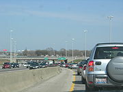
This section of I-290 is seven miles (11 km) long, and it runs from Hillside all the way to the western border of Chicago. This section is sometimes referred to as "The Avenues". As of 2002, it is the third-most congested stretch of highway in the Chicago area, behind the Circle Interchange area and the intersection of the Dan Ryan ExpresswayDan Ryan Expressway
The Dan Ryan is an expressway in the city of Chicago that runs from the Circle Interchange with I-290 near downtown Chicago through the South Side of the city. It is designated as both Interstate 94 and Interstate 90 south to 66th Street, a distance of...
and the Chicago Skyway
Chicago Skyway
The Chicago Skyway, also known as Chicago Skyway Toll Bridge System, is a toll road in Chicago, Illinois, United States, carrying Interstate 90 from the Indiana Toll Road to the Dan Ryan Expressway on Chicago's South Side leading into the Chicago Loop....
. It is known for having a high volume of traffic on ramps through the Avenues, and high volumes of traffic on left-side ramps in Forest Park and Oak Park. Interstate 290 runs above grade west of Mannheim Road, and at or below grade east of Mannheim Road.
Eastbound at Mannheim Road (exit 17), the highway splits into two express and one local lane; they are joined by two onramps from Interstate 88
Interstate 88 (west)
Interstate 88 is an intrastate Interstate Highway in the state of Illinois. It runs from an interchange with Interstate 80 near Silvis and Moline to an interchange with Interstates 290 and 294 in Hillside, near Chicago...
and form express lanes three lanes wide and local lanes to Mannheim Road two lanes wide. After Mannheim Road, the highway immediately narrows to three lanes in width, causing mile-long (1.6 km) backups. It remains three lanes to Austin Boulevard. Westbound, I-290 merely is three lanes wide to Mannheim Road, and then four lanes wide to the I-88/I-290 split. Exits at Harlem Avenue (exit 21B) and Austin Boulevard (exit 23) are left offramps and onramps, causing backups as trucks switch lanes to exit, and a large volume of traffic enters on the left side of the highway.
In 2001–2002, this section between mile markers 15 and 18 was reconstructed in the first phase of an attempt to untangle the "Hillside Strangler", adding the local lanes and extra on-ramp to Interstate 290. The second phase, reconstruction of the highway between mile markers 18 and 23 (Mannheim Road to Austin Boulevard), is still in the preliminary engineering phase of construction as of April 2009.
Austin Boulevard to Chicago Loop
This highway is four lanes wide in both directions for its entire length, and most on-ramps and off-ramps are located just two blocks apart. Therefore, an exit in one direction may be marked one street (ex. Laramie Avenue), while the same exit in the other direction may be marked another (ex. Cicero Avenue), even though the streets are only a block apart. This configuration results in most exits on this portion of road being marked as A/B exits.
Eastbound congestion is lighter here than through the "Avenues", generally limited to congestion on the tight onramps to the John F. Kennedy and Dan Ryan Expressways (the Circle Interchange) at the eastern terminus or a blind onramp at Kostner Avenue. Westbound, congestion is heavy starting at Laramie due to the left-hand exit at Austin (which combines a "perfect storm" of a four-down-to-three lane reduction, an unfamiliar left-hand exit, and entrance and in-merging traffic of the central onramp). Most afternoons, this bottleneck can skyrocket the "Post Office to Wolf (Road)" commute time to over an hour (up from 16 mins with no traffic).
The Eisenhower Expressway runs along blacktop pavement for the length of the section, except between Kostner Avenue and Independence Boulevard, where it runs on concrete pavement.
The eastern terminus of I-290 is the Circle Interchange
Circle Interchange
The Circle Interchange is an expressway interchange near downtown Chicago, Illinois. It is the junction between the Dan Ryan, Eisenhower and Kennedy expressways...
with I-90/I-94. After this junction, the route becomes an elevated and continues as a highway until LaSalle Street
LaSalle Street
LaSalle Street is a major north-south street in Chicago named for Sieur de La Salle, an early explorer of Illinois. The portion that runs through the Loop is considered to be Chicago's financial district...
, at which point it passes under LaSalle Street Station
LaSalle Street Station
LaSalle Street Station is a commuter rail terminal at 414 S. LaSalle Street in downtown Chicago, Illinois, serving Metra's Rock Island District. It was a major intercity rail terminal for the New York Central Railroad until 1968 and the Chicago, Rock Island and Pacific Railroad until 1978. The...
and comes out the other side as a city street (Congress Parkway). The Congress Parkway route continues east until the street is stopped by Buckingham Fountain
Buckingham Fountain
Buckingham Fountain is a Chicago landmark in the center of Grant Park. Dedicated in 1927, it is one of the largest fountains in the world. Built in a rococo wedding cake style and inspired by the Latona Fountain at the Palace of Versailles, it is meant to allegorically represent Lake Michigan...
.
Chicago Transit Authority
Chicago Transit Authority, also known as CTA, is the operator of mass transit within the City of Chicago, Illinois and some of its surrounding suburbs....
maintains a rail line
Blue Line (Chicago Transit Authority)
The Blue Line consists of a long trunk line in the Chicago Transit Authority's rapid transit system which extends through Chicago's Loop from O'Hare International Airport at the far northwest end of the city, through downtown via the Milwaukee-Dearborn subway, and across the West Side to its...
from the loop west to Forest Park
Forest Park (CTA)
Forest Park is a station on the Chicago Transit Authority's 'L' system, located in the city of Forest Park and serving the Blue Line. Before the Congress Line was built it served as terminal for the Garfield Line, and is possibly the only station on that line to survive today. It is the western...
that enters the median of the Eisenhower near Halsted Street and stays within the median through the Cicero
Cicero (CTA Blue Line)
Cicero is a station on the 'L' system, serving the Blue Line's Forest Park branch. It is the westernmost station situated in the median of the Eisenhower Expressway. Originally Cicero had an additional entrance at Lavergne Avenue, but this was closed on May 16, 1977, by the CTA as a cost cutting...
station. After Cicero, the line leaves the median and closely parallels the Eisenhower for the rest of its route. While convenient for mass transit, it has also severely limited any possibility of lane additions to the Eisenhower where the train line is. Preliminary studies on such an effort are already starting, however.
History
An expressway along the alignment of the Eisenhower Expressway was foreshadowed by Daniel BurnhamDaniel Burnham
Daniel Hudson Burnham, FAIA was an American architect and urban planner. He was the Director of Works for the World's Columbian Exposition in Chicago. He took a leading role in the creation of master plans for the development of a number of cities, including Chicago and downtown Washington DC...
's plan of 1909, which described a west side boulevard
Boulevard
A Boulevard is type of road, usually a wide, multi-lane arterial thoroughfare, divided with a median down the centre, and roadways along each side designed as slow travel and parking lanes and for bicycle and pedestrian usage, often with an above-average quality of landscaping and scenery...
. The passageway under the old Post Office was designed to preserve the right of way for the future road.
The Expressway is named for the former President Dwight D. Eisenhower
Dwight D. Eisenhower
Dwight David "Ike" Eisenhower was the 34th President of the United States, from 1953 until 1961. He was a five-star general in the United States Army...
, and it originally called the Congress Expressway (It begins on Congress Parkway). The political columnist Mike Royko
Mike Royko
Michael "Mike" Royko was a newspaper columnist in Chicago, who won the 1972 Pulitzer Prize for commentary...
joked that it is Chicago's only Republican expressway, since the others all named after Democrats (though since that observation Bishop Louis Henry Ford, a non-political figure, had an expressway named in his honor). The first segment, 2.5 miles (4.0 km) in length opened from Mannheim Road to 1st Avenue
Illinois Route 171
Illinois Route 171 is a north–south state road in northeastern Illinois. It runs from U.S. Route 6 in Joliet north to Illinois Route 72 at the Chicago/Park Ridge border...
in December 1955. On December 15th, 4 additional miles (6 km) opened, from Ashland Avenue (1600 West) to Laramie Avenue (5200 West).
During the 1960s and 1970s, the Eisenhower Expressway was extended to Lake Street
U.S. Route 20 in Illinois
In the U.S. state of Illinois, U.S. Route 20 is a major arterial highway that runs from the Iowa state line at East Dubuque at the northwestern tip of Illinois, to the Indiana state line at Chicago south of the Chicago Skyway. A distance of .For its entire length, US 20 is designated as the...
and North Avenue
Illinois Route 64
Illinois Route 64 is an east–west road in north-central Illinois. Its western terminus is at the Iowa state line, connecting with U.S. Route 52 and Iowa Highway 64 via the Savanna-Sabula Bridge at the Mississippi River west of Savanna...
. In 1963, the first working example of ramp meter
Ramp meter
A ramp meter, ramp signal or metering light is a device, usually a basic traffic light or a two-section signal light together with a signal controller, that regulates the flow of traffic entering freeways according to current traffic conditions...
ing took place on the Eisenhower Expressway, based on successful metering through New York City
New York City
New York is the most populous city in the United States and the center of the New York Metropolitan Area, one of the most populous metropolitan areas in the world. New York exerts a significant impact upon global commerce, finance, media, art, fashion, research, technology, education, and...
tunnels and data from ramp closures in Detroit, Michigan
Detroit, Michigan
Detroit is the major city among the primary cultural, financial, and transportation centers in the Metro Detroit area, a region of 5.2 million people. As the seat of Wayne County, the city of Detroit is the largest city in the U.S. state of Michigan and serves as a major port on the Detroit River...
. The first implementation utilized a police officer at the top of an entrance ramp, stopping and releasing vehicles onto the highway at a predetermined rate. Another section opened in 1972, to a north–south expressway in Addison, Illinois
Addison, Illinois
Addison is a village located west of the Chicago Metropolitan Area, in DuPage County, Illinois, United States. The population was 35,914 at the 2000 census. The estimated population was 36,378 as of 2002.The Village of Addison lies on Salt Creek...
. At the time, this expressway was a short spur from the Eisenhower Expressway, and it was referred to as Illinois Route 53
Illinois Route 53
Illinois Route 53 is an arterial north–south state highway in northeast Illinois. Route 53 runs south from Long Grove at Illinois Route 83 to Gardner at Interstate 55 west of old U.S. Highway 66, a distance of...
, which continued north to Schaumburg. Construction on Illinois 53 had finished in 1970.
Until 1978, the Eisenhower Expressway was marked as a part of Interstate 90. In 1978, the Interstate 90 designation was moved onto the John F. Kennedy Expressway and the Northwest Tollway
Northwest Tollway
The Jane Addams Memorial Tollway in Illinois is a 79-mile segment of Interstate 90 from Interstate 190 in far northwest Chicago to Illinois Route 75, one mile south of the Wisconsin state line. For 16 miles , Interstate 90 is concurrent with Interstate 39 and U.S. Route 51...
, replacing Illinois Route 194. The Eisenhower Expressway was then renumbered as Interstate 290.
Because the segment from Interstate 294 to Illinois 53 was built last, that portion of the highway is referred to as the Eisenhower Extension. The Eisenhower Expressway, extension included, is 23 miles (37 km) long. If the Illinois 53 portion of Interstate 290 is added to that, the highway is actually 30 miles (48 km) long.
In 2003-2004, the first five miles (8 km) of Interstate 290 out of Schaumburg
Schaumburg, Illinois
Schaumburg is a city located in Cook County in northeastern Illinois. A common misspelling of the city name is Schaumberg, a spelling which persists on some modern maps. Schaumburg is located just under northwest of downtown Chicago and approximately northwest of O'Hare International Airport. As...
were rebuilt, replacing pavement that had well-exceeded its estimated 20 year lifetime. (The original pavement was built in stages from 1963 through 1970 as part of Illinois 53.) A fifth auxiliary lane was added between the entrance and exit ramps of exits 1, 4 and 5. The most important safety upgrade was the demolition of the raised grassy median between the westbound and eastbound lanes, and its replacement with a permanent concrete median and wide shoulders.
- Hillside Strangler — Named after the Chicago suburb of HillsideHillside, IllinoisHillside is a village in Cook County, Illinois, United States. The population was 8,155 at the 2000 census.One notable landmark in Hillside is the Mount Carmel Cemetery. On the grounds of the cemetery are the graves of a number of organized crime figures, such as Al Capone and Dion O'Bannion...
, it refers to a major merge with Interstate 88Interstate 88 (west)Interstate 88 is an intrastate Interstate Highway in the state of Illinois. It runs from an interchange with Interstate 80 near Silvis and Moline to an interchange with Interstates 290 and 294 in Hillside, near Chicago...
, and almost always is used when referring to inbound (eastbound) traffic. It is at this point that Interstate 88 terminates eastbound. It was called the Strangler because before its reconstruction in the early 2000s, seven through lanes were forced to merge to three, creating large backups. Urban legend suggests that the former Columbia College student Robert Spryszak was the first known to use the expression relating to the traffic pattern in the late 70s during the "Hillside StranglerHillside StranglerThe Hillside Strangler is the media epithet for two men, cousins Kenneth Bianchi and Angelo Buono, who were convicted of kidnapping, raping, torturing, and killing girls and women ranging in age from 12 to 28 years old during a four-month period from late 1977 to early 1978...
" murders media craze. Reconstruction widened part of this area to nine lanes (five inbound; three through; two local; and four through lanes outbound). This allowed direct exits to Mannheim Road (U.S. Routes 12U.S. Route 12U.S. Route 12 or US 12 is an east–west United States highway, running from Grays Harbor on the Pacific Ocean, in the state of Washington, to downtown Detroit, for almost . As a thoroughfare, it has mostly been supplanted by I-90 and I-94, but remains an important road for local travel.The...
/20U.S. Route 20U.S. Route 20 is an east–west United States highway. As the "0" in its route number implies, US 20 is a coast-to-coast route. Spanning , it is the longest road in the United States, and the route sparsely parallels Interstate 90...
/45U.S. Route 45U.S. Route 45 is a north–south United States highway. US 45 is a border-to-border route, from Lake Superior to the Gulf of Mexico. A sign at the highway's northern terminus notes the total distance as ....
) from Interstate 88, the ramp also serving for an Interstate 88 truck access to eastbound Interstate 290; created an inbound collector-distributor ramp for Mannheim Road; and added a timed gate that closed a ramp from Roosevelt RoadRoosevelt RoadRoosevelt Road is a major east-west thoroughfare in the city of Chicago, Illinois, and its western suburbs. It is 1200 South in the city's street numbering system, but only one mile south of Madison Street...
(Illinois Route 38Illinois Route 38Illinois Route 38 is an east–west state road that runs across northern Illinois. It runs from U.S. Route 52 in downtown Dixon to U.S. Highways 12, 20, and 45 in Westchester. This is a distance of . As Roosevelt Road it continues through Forest Park and into Cicero and Chicago before...
) to inbound Interstate 290 during the afternoon rush hours. These improvements helped congestion at the site, but they also pushed pre-existing congestion further east to the six-lane portion of the highway. The Hillside Strangler is located at about mile marker 18.
- The Avenues — The portion of the highway between Mannheim Road at mile marker 17 and First Avenue in MaywoodMaywood, IllinoisMaywood is a village in Proviso Township, Cook County, Illinois, United States. It was founded on April 6, 1869 and organized October 22, 1881. The population was 26,987 at the 2000 census.-Overview:...
, a stretch of 3 miles (5 km). Named because all of the crossroads between these two exits are named numerically, in ascending order traveling outbound (westbound). 1st Avenue (Illinois Route 171Illinois Route 171Illinois Route 171 is a north–south state road in northeastern Illinois. It runs from U.S. Route 6 in Joliet north to Illinois Route 72 at the Chicago/Park Ridge border...
) is exit 20. There are exits to 9th Avenue, 17th Avenue, and 25th Avenue to the west. These exits are spaced about 3/4ths of a mile (1200 m) apart. This stretch is notorious for being very congested.
- The Eisenhower Extension or 290 Extension — The eight miles (12 km) of road between current-day mile marker seven (Interstate 355Interstate 355Interstate 355 , also known as the Veterans Memorial Tollway, is an Interstate Highway and tollway in the western and southwest suburbs of Chicago, Illinois, U.S. Like most other toll roads in the northeastern portion of the state, I-355 is maintained by a State Highway Authority...
south to US 20U.S. Route 20 in IllinoisIn the U.S. state of Illinois, U.S. Route 20 is a major arterial highway that runs from the Iowa state line at East Dubuque at the northwestern tip of Illinois, to the Indiana state line at Chicago south of the Chicago Skyway. A distance of .For its entire length, US 20 is designated as the...
/Lake Street) and North Avenue (Illinois Route 64Illinois Route 64Illinois Route 64 is an east–west road in north-central Illinois. Its western terminus is at the Iowa state line, connecting with U.S. Route 52 and Iowa Highway 64 via the Savanna-Sabula Bridge at the Mississippi River west of Savanna...
), mile marker 15. This section was built in the late 1970s.
- The Circle InterchangeCircle InterchangeThe Circle Interchange is an expressway interchange near downtown Chicago, Illinois. It is the junction between the Dan Ryan, Eisenhower and Kennedy expressways...
— The eastern terminus of Interstate 290 where it meets Interstates 90 and 94, which overlap through Chicago. North of this interchange Interstates 90 and 94 are called the Kennedy Expressway, while south of it Interstates 90 and 94 are called the Dan Ryan Expressway. The interchange itself consists of eight heavily used, very tight ramps that wind around each other, giving the interchange a distinct circle shape when looked at from above. This design, adequate when first built in the 1950s, forces drivers to slow down to speeds of about 20 mph (32 km/h) due to its tightly wound curves. This currently causes the worst congestion in the Chicago area. However, the redesign of the interchange has been determined to be prohibitively expensive because of the relatively small, four city-block area that the interchange is built upon.
Post Office
Just east of the I-290 - I-90/94 Junction in downtown Chicago, the Old Chicago Main Post Office is a building that stretches over Congress Parkway. If one drives eastbound on I-290 and continues past I-90/94, the highway ends and becomes Congress Parkway. The Post Office was a landmark that was sometimes used in referring to the end of I-290 in downtown Chicago. For example, a traffic reporter might say "... forty minutes from Mannheim to the Post Office...".This large building was used by the United States Postal Service
United States Postal Service
The United States Postal Service is an independent agency of the United States government responsible for providing postal service in the United States...
until 1996. The building itself was built from 1921 to 1933 in the Art-Deco style, and it is 2.5 million square feet (230,000 m²) in size. The building, built several decades before the expressway that passes through it, was originally designed to accommodate a roadway - requiring only minimal work to remove walls in the base for the freeway to pass through. In spite of its unused state, the building is still known to visitors and commuters alike as the unofficial gateway into the Chicago Loop area. In late August, 2009, The United States Postal Service announced an auction was to be held to sell the facility to the highest bidder. The winning bid ($40 million) was from an English real estate developer, Bill Davies http://www.nbcchicago.com/news/local-beat/Post-Office-Buyer-May-Not-Deliver-58048172.html.
Exit list
| County | Location | Mile | # Exit number An exit number is a number assigned to a road junction, usually an exit from a freeway. It is usually marked on the same sign as the destinations of the exit, as well as a sign in the gore.... |
Destinations | Notes |
|---|---|---|---|---|---|
| Cook Cook County, Illinois Cook County is a county in the U.S. state of Illinois, with its county seat in Chicago. It is the second most populous county in the United States after Los Angeles County. The county has 5,194,675 residents, which is 40.5 percent of all Illinois residents. Cook County's population is larger than... Mile 0.00-4.55 |
Schaumburg Schaumburg, Illinois Schaumburg is a city located in Cook County in northeastern Illinois. A common misspelling of the city name is Schaumberg, a spelling which persists on some modern maps. Schaumburg is located just under northwest of downtown Chicago and approximately northwest of O'Hare International Airport. As... |
0.0 | – North Suburbs | Continuation beyond I-90 | |
| 0.0 | |||||
| 0.60 | 1A | Northbound exit combines exits 1A and 1B into single exit 1 | |||
| 1.44 | 1B | ||||
| Elk Grove Village Elk Grove Village, Illinois Elk Grove Village is a municipality located in northeastern Illinois adjacent to O'Hare International Airport and the City of Chicago. Elk Grove Village encompasses in land area with located in Cook County and located in DuPage County, Illinois. The population was 32,745 at the 2010 census... |
3.93 | 4 | East end of IL 53 overlap | ||
| DuPage DuPage County, Illinois As of the 2010 Census, the population of the county was 916,924, White Americans made up 77.9% of Dupage County's population; non-Hispanic whites represented 70.5% of the population. Black Americans made up 4.6% of the population. Native Americans made up 0.3% of Dupage County's population... Mile 0.00-9.33 |
Itasca Itasca, Illinois Itasca is a village in DuPage County, Illinois, United States. The population was 8,302 at the 2000 census.In 2009, BusinessWeek rated Itasca as the 'Best Affordable Suburb' in the state of Illinois... |
5.03 | 5 | ||
| Addison Addison, Illinois Addison is a village located west of the Chicago Metropolitan Area, in DuPage County, Illinois, United States. The population was 35,914 at the 2000 census. The estimated population was 36,378 as of 2002.The Village of Addison lies on Salt Creek... |
6.46 | 7 | US 20 exit is accessible westbound only. Eastbound exit to US 20 is on I-355. | ||
| 10.69 | 10 | Signed as exits 10A (south) and 10B (north) | |||
| Elmhurst Elmhurst, Illinois Elmhurst is a suburb of Chicago in DuPage and Cook Counties, Illinois. The population is 46,013 as of the 2008 US Census population estimate.-History:... |
12.34 | 12 | West end of US 20 overlap | ||
| 13.41 | 13B | Westbound exit and eastbound entrance | |||
| 13.41 | 13A | East end of US 20 overlap | |||
| Berkeley Berkeley, Illinois Berkeley is a village located in Cook County, Illinois, United States. Incorporated in 1924, the population at the 2000 census was 5,245.The town has a commuter railroad station on Metra's Union Pacific/West Line with service to downtown Chicago.-Geography:... |
14.76 | 14 | St. Charles Road | Signed as exits 14A (west) and 14B (east) | |
| Hillside Hillside, Illinois Hillside is a village in Cook County, Illinois, United States. The population was 8,155 at the 2000 census.One notable landmark in Hillside is the Mount Carmel Cemetery. On the grounds of the cemetery are the graves of a number of organized crime figures, such as Al Capone and Dion O'Bannion... |
15.33 | 15B | – Milwaukee | Eastbound exit is via exit 13A | |
| Cook Cook County, Illinois Cook County is a county in the U.S. state of Illinois, with its county seat in Chicago. It is the second most populous county in the United States after Los Angeles County. The county has 5,194,675 residents, which is 40.5 percent of all Illinois residents. Cook County's population is larger than... Mile 4.55-20.51 |
15.97 | 15A | , Indiana Indiana Indiana is a US state, admitted to the United States as the 19th on December 11, 1816. It is located in the Midwestern United States and Great Lakes Region. With 6,483,802 residents, the state is ranked 15th in population and 16th in population density. Indiana is ranked 38th in land area and is... |
||
| 16.44 | 16 | Wolf Road | Westbound exit and eastbound entrance | ||
| 17.52 | 17 | Signed as exits 17A (east/south) and 17B (west/north) eastbound | |||
| Maywood Maywood, Illinois Maywood is a village in Proviso Township, Cook County, Illinois, United States. It was founded on April 6, 1869 and organized October 22, 1881. The population was 26,987 at the 2000 census.-Overview:... |
18.54 | 18 | 25th Avenue | Signed as exits 18A (south) and 18B (north) | |
| 19.05 | 19A | 17th Avenue | |||
| 19.56 | 19B | 9th Avenue | Westbound exit and eastbound entrance | ||
| 20.06 | 20 | ||||
| Forest Park Forest Park, Illinois Forest Park is a village in Cook County, Illinois, a suburb of Chicago in the United States. The population was 15,688 at the 2000 census... |
21.02 | 21A | Des Plaines Avenue (7600 West) | Westbound entrance and eastbound exit | |
| Oak Park Oak Park, Illinois Oak Park, Illinois is a suburb bordering the west side of the city of Chicago in Cook County, Illinois, United States. It is the twenty-fifth largest municipality in Illinois. Oak Park has easy access to downtown Chicago due to public transportation such as the Chicago 'L' Blue and Green lines,... |
21.58 | 21B | |||
| 23.09 | 23A | Austin Boulevard (6000 West) | |||
| Chicago | 23.63 | 23B | Central Avenue (5600 West) | ||
| 24.09 | 24A | Laramie Avenue (5200 West) | Westbound exit and eastbound entrance | ||
| 24.61 | 24B | -Midway Airport Midway Airport Chicago Midway International Airport , also known simply as Midway Airport or Midway, is an airport in Chicago, Illinois, United States, located on the city's southwest side, eight miles from Chicago's Loop... |
Eastbound exit and westbound entrance | ||
| 25.14 | 25 | Kostner Avenue (4400 West) | Westbound exit and eastbound entrance | ||
| 25.70 | 26A | Independence Boulevard (3800 West) | |||
| 26.41 | 26B | Homan Avenue (3400 West) | Westbound exit and eastbound entrance | ||
| 26.90 | 27A | Sacramento Avenue (3000 West) | Eastbound exit and westbound entrance | ||
| 27.15 | 27B | California Avenue (2800 West) | Westbound exit and eastbound entrance | ||
| 27.67 | 27C | Western Avenue Western Avenue (Chicago) Western Avenue is the longest continuous street within the city of Chicago at in length. Western Avenue extends south as a continuous road to the Dixie Highway at Sibley Boulevard in Dixmoor, giving the road a total length of . However, Western Avenue extends intermittently through the... (2400 West), Oakley Boulevard (2300 West) |
|||
| 28.17 | 28A | Damen Avenue (2000 West) | Exit to United Center | ||
| 28.54 | 28B | Paulina Street (1700 West), Ashland Boulevard (1600 West) | |||
| 29.43 | 29A | Racine Avenue (1200 West) | Eastbound exit and westbound entrance | ||
| 29.53 | 29B | Morgan Street (1000 West) | Westbound exit only | ||
| 29.84 | – Indiana Indiana Indiana is a US state, admitted to the United States as the 19th on December 11, 1816. It is located in the Midwestern United States and Great Lakes Region. With 6,483,802 residents, the state is ranked 15th in population and 16th in population density. Indiana is ranked 38th in land area and is... , Wisconsin Wisconsin Wisconsin is a U.S. state located in the north-central United States and is part of the Midwest. It is bordered by Minnesota to the west, Iowa to the southwest, Illinois to the south, Lake Michigan to the east, Michigan to the northeast, and Lake Superior to the north. Wisconsin's capital is... |
Circle Interchange Circle Interchange The Circle Interchange is an expressway interchange near downtown Chicago, Illinois. It is the junction between the Dan Ryan, Eisenhower and Kennedy expressways... ; east end of I-290 |
|||
| 0.32 | Canal Street (500 West) | Eastbound exit and westbound entrance. Mileposts are measured from the Circle Interchange. | |||
| 0.48 | Congress Parkway Bridge over the Chicago River Chicago River The Chicago River is a system of rivers and canals with a combined length of that runs through the city of the same name, including its center . Though not especially long, the river is notable for being the reason why Chicago became an important location, as the link between the Great Lakes and... |
||||
| 0.55 | Wacker Drive Wacker Drive Wacker Drive is a major street in Chicago, Illinois, United States, running along the south side of the main branch and the east side of the south branch of the Chicago River... , Franklin Street (300 West) |
Eastbound exit and westbound entrance | |||
| 0.56 | Wells Street Wells Street (Chicago) Wells Street is a main North–South road in downtown Chicago. It is officially designated as 200 West, and is named in honor of William Wells, a United States Army Captain who died in the Battle of Fort Dearborn.... (200 West) |
At-grade intersection At-grade intersection An at-grade intersection is a junction at which two or more transport axes cross at the same level .-Traffic management:With areas of high or fast traffic, an at-grade intersection normally requires a traffic control device such as a stop sign, traffic light or railway signal to manage conflicting... |
|||
| 0.56 | Congress Parkway (500 South) | Continuation beyond Wells Street | |||