
Ohio Turnpike
Encyclopedia
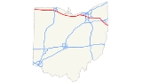
The Ohio Turnpike, officially the James W. Shocknessy Ohio Turnpike, is a 241.26 mi (388.27 km)-long, limited-access toll highway
in the U.S. state of Ohio
, serving as a primary corridor to Chicago
and Pittsburgh
. The road runs east–west in the northern section of the state, from the Indiana Toll Road
(at the Indiana
–Ohio border near Bryan
) to the Pennsylvania Turnpike
(at the Ohio–Pennsylvania
border near Petersburg). The road is owned and maintained by the Ohio Turnpike Commission, headquartered in Berea
.
Built from 1949 to 1955, construction for the roadway was completed a year prior to the Interstate Highway System
. The modern Ohio Turnpike is signed as three interstate numbers: Interstate 76
(I-76), I-80, and I-90
.
leaves off at the Ohio-Indiana border, and carries both I-80 and I-90 to Elyria. I-90 splits off there, and the Turnpike continues with I-80 by itself to Youngstown. At Youngstown, I-80 leaves the Turnpike and I-76 enters it. The Turnpike then continues, as I-76, to the Pennsylvania border, where the road becomes the Pennsylvania Turnpike
.
 The Ohio General Assembly
authorized the formation of the Ohio Turnpike Commission in 1949. The turnpike is named after the first chairman of the commission, James W. Shocknessy
. Construction for the road cost $326 million and was recorded the biggest project in state history, with 10,000 employees, more than 2,300 bulldozers, graders, loaders and other machines over a 38-month period.
On December 1, 1954, the first 22 miles (35.4 km) stretch (the portion lying east of SR 18) opened near the present-day exit 218 for I-76
and I-80. Several motorists attended a dedication ceremony, with over 1,000 people joining a caravan, following a snow plow and a patrol cruiser, to become the first to drive the turnpike. The remaining section from exit 218 west to Indiana opened on October 1, 1955. Originally, the turnpike offered 18 access points. Additional access points have since been provided, bringing the total number to 31.
In 1996, the turnpike began a project to add a lane in each direction from Toledo to Youngstown. The project, using financing from increased tolls, was originally projected to be finished in 2005, but in 2009 there were still short stretches without the added lanes—one at the west end of the project in Lucas
and Wood
counties, and the other in Summit County
at exit 180 (SR 8); construction on the former stretch is to begin construction in 2012, while the latter is to begin in 2011 and be completed in 2012.
In 1998, the Ohio Turnpike Commission began phasing in distance-based exit number
s; the sequential numbering system was retired in September 2002. In 2009, the Ohio Turnpike Commission began accepting E-ZPass
for toll payment at all plazas, and added gates to toll lanes to prevent motorists from evading tolls.
Ken Blackwell, the defeated candidate in the 2006 Ohio governor's race
, had announced a plan for privatizing the turnpike, similar to plans enacted in Illinois
and Indiana
. In 2010 and 2011, Governor John Kasich
stated that he would consider a turnpike lease, but only during a prosperous economic period. , Kasich intends to create a task force to produce a leasing plan by spring 2013; if he disapproves of the plan, he will consider other options including reassigning the maintenance of the highway to the Ohio Department of Transportation
.
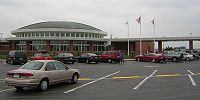 The Ohio Turnpike has had service plazas since its inception. Service plazas differ from typical freeway rest areas in that they offer amenities such as 24-hour food and fuel service, which means motorists do not have to pay the toll to exit, then re-enter when they have to re-fuel, use the restroom, or stop to eat.
In 1998, The Ohio Turnpike Commission began modernizing its service plazas, first demolishing the original plazas and then reconstructing them from the ground up. In addition to modern restrooms, the new plazas offer several fast food
choices, which vary between the plazas. They also include ATMs
, gift shops, travel information counters, Wi-Fi
internet access, and facilities for truck drivers, including shower facilities, lounge, and laundry areas. A fueling station provided by Valero is provided at plazas at mile markers 49, 76, 100, 139, 170, and 197. Philadelphia-based Sunoco
is provided at the plaza near mile markers 20 and 237. Facilities for overnight RV campers are provided at the service plazas located at mile markers 20, 76, 139, and 197.
Service plazas are located in pairs (one for each side of the turnpike) near mile markers 20, 49, 76, 100, 139, 170, 197, and 237. Presently, the service plazas located at mile marker 49 have not been modernized, but they are scheduled to close in December 2011 for reconstruction.
.jpg) The service plazas located in Lucas County
The service plazas located in Lucas County
west of Toledo
at mile marker 49 are the least utilized. The Ohio Turnpike Commission envisions the eventual demolition of these service plazas, and construction of new plazas between mile markers 20 and 49; the new facility will most likely be located in Fulton County
and is expected to open after 2012. Due to the lack of a municipal water/sewer system
, the service plazas located near mile marker 20 in Williams County
were demolished in 2006, though they were eventually rebuilt and reopened on June 29, 2011. The plazas at mile 237 are currently closed for reconstruction, and are expected to reopen in the summer of 2012.
Since the turnpike opened, the Ohio Turnpike Commission has contracted with the Ohio State Highway Patrol
(District 10) to provide law enforcement, as well as assistance to disabled or stranded motorists. The Patrol is the only law enforcement agency with jurisdiction on the turnpike. It monitors Citizen's Band channel 9 for distress calls.
In 2008, legislation was introduced to raise the speed limit to 70 miles per hour (31.3 m/s); however, it died in the legislature. The National Motorists Association provides support for legislative attempts to increase legal speed limits to reflect actual travel speeds on highways.
On December 20, 2010, the Ohio Turnpike Commission voted to increase the speed limit of the Ohio Turnpike to 70 miles per hour (31.3 m/s). Despite opposition from the Ohio Trucking Association and the Ohio Motorists Association, the increase was approved by the Commission by a vote of 4–1 and went into effect on April 1, 2011.
 In September 2004, the speed limit
for heavy trucks was raised to 65 mph (29.1 m/s), creating a uniform speed limit for all traffic. For years, trucks had avoided the turnpike due to large toll increases in the 1990s, and because they could travel for free at the same speed on parallel highways such as SR 2 and US 20. Truck traffic clogged the downtown shopping areas of US 20 towns such as Bellevue
and Clyde
, essentially driving away customers who didn't want to deal with the truck traffic; shopkeepers begged the state for relief for years.
Eventually, after prodding by Governor Bob Taft
, the Ohio Turnpike Commission lowered truck tolls and implemented the uniform 65 mi/h speed limit on September 8, 2004. Truck traffic levels on the turnpike are estimated to be 20% higher since the change was made. The turnpike's 65 mph (104.6 km/h) truck speed limit was unique in Ohio, as a 55 mph (88.5 km/h) statutory speed limit applied to trucks on every other highway in the state until the passage of House Bill Number 2 in 2009.
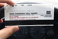 Tolls are based upon the distance traveled, as well as the type and weight of vehicle driven. , the toll for a typical non-commercial passenger vehicle to travel the entire turnpike is $10.25 for E-ZPass
holders and $15.00 for non E-ZPass holders.
The Ohio Turnpike Commission had been hesitant to deploy an electronic tolling system, citing an apparent lack of commuter travel as well as significant implementation expenses. In December 2006, the commission indicated their intention to move forward with the implementation of an E-ZPass-compatible system as a "customer convenience". The system was activated on October 1, 2009. In 2009, the turnpike became the first publicly-owned toll facility in the U.S.—and the second overall—to allow users to pay tolls with a debit or credit card.
In April 2008, governor Ted Strickland
and legislative leaders announced a planned stimulus package that would redistribute Turnpike tolls to road projects throughout the state. On May 23, the Ohio Senate
Finance Committee voted to pass a new version of the package which would not involve tolls collected.
Toll road
A toll road is a privately or publicly built road for which a driver pays a toll for use. Structures for which tolls are charged include toll bridges and toll tunnels. Non-toll roads are financed using other sources of revenue, most typically fuel tax or general tax funds...
in the U.S. state of Ohio
Ohio
Ohio is a Midwestern state in the United States. The 34th largest state by area in the U.S.,it is the 7th‑most populous with over 11.5 million residents, containing several major American cities and seven metropolitan areas with populations of 500,000 or more.The state's capital is Columbus...
, serving as a primary corridor to Chicago
Chicago
Chicago is the largest city in the US state of Illinois. With nearly 2.7 million residents, it is the most populous city in the Midwestern United States and the third most populous in the US, after New York City and Los Angeles...
and Pittsburgh
Pittsburgh, Pennsylvania
Pittsburgh is the second-largest city in the US Commonwealth of Pennsylvania and the county seat of Allegheny County. Regionally, it anchors the largest urban area of Appalachia and the Ohio River Valley, and nationally, it is the 22nd-largest urban area in the United States...
. The road runs east–west in the northern section of the state, from the Indiana Toll Road
Indiana Toll Road
The Indiana Toll Road, officially the Indiana East–West Toll Road, is a toll road that runs for east–west across northern Indiana from the Illinois state line to the Ohio state line...
(at the Indiana
Indiana
Indiana is a US state, admitted to the United States as the 19th on December 11, 1816. It is located in the Midwestern United States and Great Lakes Region. With 6,483,802 residents, the state is ranked 15th in population and 16th in population density. Indiana is ranked 38th in land area and is...
–Ohio border near Bryan
Bryan, Ohio
As of the census of 2000, there were 8,333 people, 3,528 households, and 2,155 families residing in the city. The population density was 1,821.7 people per square mile . There were 3,733 housing units at an average density of 816.1 per square mile...
) to the Pennsylvania Turnpike
Pennsylvania Turnpike
The Pennsylvania Turnpike is a toll highway system operated by the Pennsylvania Turnpike Commission in the Commonwealth of Pennsylvania, United States. The three sections of the turnpike system total . The main section extends from Ohio to New Jersey and is long...
(at the Ohio–Pennsylvania
Pennsylvania
The Commonwealth of Pennsylvania is a U.S. state that is located in the Northeastern and Mid-Atlantic regions of the United States. The state borders Delaware and Maryland to the south, West Virginia to the southwest, Ohio to the west, New York and Ontario, Canada, to the north, and New Jersey to...
border near Petersburg). The road is owned and maintained by the Ohio Turnpike Commission, headquartered in Berea
Berea, Ohio
- History :The first European settlers were originally from Connecticut. Berea fell within Connecticut's Western Reserve and was surveyed and divided into townships and ranges by one Gideon Granger, a gentleman who served as Postmaster General under President Thomas Jefferson...
.
Built from 1949 to 1955, construction for the roadway was completed a year prior to the Interstate Highway System
Interstate Highway System
The Dwight D. Eisenhower National System of Interstate and Defense Highways, , is a network of limited-access roads including freeways, highways, and expressways forming part of the National Highway System of the United States of America...
. The modern Ohio Turnpike is signed as three interstate numbers: Interstate 76
Interstate 76 in Ohio
In the U.S. state of Ohio, Interstate 76 runs for from Interstate 71 south of Cleveland to the Pennsylvania state line south of Youngstown. Once numbered Interstate 80S, Interstate 76 now comprises the easternmost leg of the Ohio Turnpike.-Route description:...
(I-76), I-80, and I-90
Interstate 90 in Ohio
In the U.S. state of Ohio, Interstate 90 runs east–west across the northern tier. Much of it is along the Ohio Turnpike, but sections outside the turnpike pass through Cleveland and northeast into Pennsylvania.-Route description:...
.
Route description
The Ohio Turnpike picks up where the Indiana Toll RoadIndiana Toll Road
The Indiana Toll Road, officially the Indiana East–West Toll Road, is a toll road that runs for east–west across northern Indiana from the Illinois state line to the Ohio state line...
leaves off at the Ohio-Indiana border, and carries both I-80 and I-90 to Elyria. I-90 splits off there, and the Turnpike continues with I-80 by itself to Youngstown. At Youngstown, I-80 leaves the Turnpike and I-76 enters it. The Turnpike then continues, as I-76, to the Pennsylvania border, where the road becomes the Pennsylvania Turnpike
Pennsylvania Turnpike
The Pennsylvania Turnpike is a toll highway system operated by the Pennsylvania Turnpike Commission in the Commonwealth of Pennsylvania, United States. The three sections of the turnpike system total . The main section extends from Ohio to New Jersey and is long...
.
History
Ohio General Assembly
The Ohio General Assembly is the state legislature of the U.S. state of Ohio. It consists of the 99-member Ohio House of Representatives and the 33-member Ohio Senate...
authorized the formation of the Ohio Turnpike Commission in 1949. The turnpike is named after the first chairman of the commission, James W. Shocknessy
James W. Shocknessy
James W. Shocknessy was a politician from Columbus, Ohio of the Democratic party.Shocknessy was the first chairman of the Ohio Turnpike Commission, and was a delegate to the Democratic National Convention from Ohio in 1956 and 1960...
. Construction for the road cost $326 million and was recorded the biggest project in state history, with 10,000 employees, more than 2,300 bulldozers, graders, loaders and other machines over a 38-month period.
On December 1, 1954, the first 22 miles (35.4 km) stretch (the portion lying east of SR 18) opened near the present-day exit 218 for I-76
Interstate 76 (east)
Interstate 76 is an Interstate Highway in the United States, running 435 miles from an interchange with Interstate 71 west of Akron, Ohio, east to Interstate 295 near Camden, New Jersey....
and I-80. Several motorists attended a dedication ceremony, with over 1,000 people joining a caravan, following a snow plow and a patrol cruiser, to become the first to drive the turnpike. The remaining section from exit 218 west to Indiana opened on October 1, 1955. Originally, the turnpike offered 18 access points. Additional access points have since been provided, bringing the total number to 31.
In 1996, the turnpike began a project to add a lane in each direction from Toledo to Youngstown. The project, using financing from increased tolls, was originally projected to be finished in 2005, but in 2009 there were still short stretches without the added lanes—one at the west end of the project in Lucas
Lucas County, Ohio
----...
and Wood
Wood County, Ohio
Wood County is a county located in the state of Ohio, United States. As of the 2010 census, the population was 125,488. Its county seat is Bowling Green. The county was named for Captain Eleazer D. Wood, the engineer for General William Henry Harrison's army, who built Fort Meigs in the War of 1812...
counties, and the other in Summit County
Summit County, Ohio
Summit County is an urban county located in the state of Ohio, United States. As of the 2000 census, the population was 542,899. In the 2010 Census the population was 541,781. Its county seat is Akron...
at exit 180 (SR 8); construction on the former stretch is to begin construction in 2012, while the latter is to begin in 2011 and be completed in 2012.
In 1998, the Ohio Turnpike Commission began phasing in distance-based exit number
Exit number
An exit number is a number assigned to a road junction, usually an exit from a freeway. It is usually marked on the same sign as the destinations of the exit, as well as a sign in the gore....
s; the sequential numbering system was retired in September 2002. In 2009, the Ohio Turnpike Commission began accepting E-ZPass
E-ZPass
E-ZPass is an electronic toll-collection system used on most tolled roads, bridges, and tunnels in the northeastern US, south to Virginia and West Virginia, and west to Illinois. Currently, there are 25 agencies spread across 14 states that make up the . All member agencies use the same technology,...
for toll payment at all plazas, and added gates to toll lanes to prevent motorists from evading tolls.
Ken Blackwell, the defeated candidate in the 2006 Ohio governor's race
Ohio gubernatorial election, 2006
The Ohio gubernatorial election of 2006 was held on November 7, 2006, and was a race for the Governor and Lieutenant Governor of Ohio. Incumbent Governor Bob Taft could not run for re-election, as Ohio governors are limited to two consecutive terms in office....
, had announced a plan for privatizing the turnpike, similar to plans enacted in Illinois
Chicago Skyway
The Chicago Skyway, also known as Chicago Skyway Toll Bridge System, is a toll road in Chicago, Illinois, United States, carrying Interstate 90 from the Indiana Toll Road to the Dan Ryan Expressway on Chicago's South Side leading into the Chicago Loop....
and Indiana
Indiana Toll Road
The Indiana Toll Road, officially the Indiana East–West Toll Road, is a toll road that runs for east–west across northern Indiana from the Illinois state line to the Ohio state line...
. In 2010 and 2011, Governor John Kasich
John Kasich
John Richard Kasich is the 69th and current Governor of Ohio. A member of the Republican Party, he previously served as a member of the United States House of Representatives, representing from 1983 to 2001...
stated that he would consider a turnpike lease, but only during a prosperous economic period. , Kasich intends to create a task force to produce a leasing plan by spring 2013; if he disapproves of the plan, he will consider other options including reassigning the maintenance of the highway to the Ohio Department of Transportation
Ohio Department of Transportation
The Ohio Department of Transportation is the organization of state government responsible for developing and maintaining all state and federal roadways in the state of Ohio with exception of the Ohio Turnpike. In addition to highways, the department also helps develop public transportation and...
.
Services
In 1998, The Ohio Turnpike Commission began modernizing its service plazas, first demolishing the original plazas and then reconstructing them from the ground up. In addition to modern restrooms, the new plazas offer several fast food
Fast food
Fast food is the term given to food that can be prepared and served very quickly. While any meal with low preparation time can be considered to be fast food, typically the term refers to food sold in a restaurant or store with preheated or precooked ingredients, and served to the customer in a...
choices, which vary between the plazas. They also include ATMs
Automated teller machine
An automated teller machine or automatic teller machine, also known as a Cashpoint , cash machine or sometimes a hole in the wall in British English, is a computerised telecommunications device that provides the clients of a financial institution with access to financial transactions in a public...
, gift shops, travel information counters, Wi-Fi
Wi-Fi
Wi-Fi or Wifi, is a mechanism for wirelessly connecting electronic devices. A device enabled with Wi-Fi, such as a personal computer, video game console, smartphone, or digital audio player, can connect to the Internet via a wireless network access point. An access point has a range of about 20...
internet access, and facilities for truck drivers, including shower facilities, lounge, and laundry areas. A fueling station provided by Valero is provided at plazas at mile markers 49, 76, 100, 139, 170, and 197. Philadelphia-based Sunoco
Sunoco
Sunoco Inc. is an American petroleum and petrochemical manufacturer headquartered in Philadelphia, Pennsylvania, United States, formerly known as Sun Company Inc. and Sun Oil Co. ....
is provided at the plaza near mile markers 20 and 237. Facilities for overnight RV campers are provided at the service plazas located at mile markers 20, 76, 139, and 197.
Service plazas are located in pairs (one for each side of the turnpike) near mile markers 20, 49, 76, 100, 139, 170, 197, and 237. Presently, the service plazas located at mile marker 49 have not been modernized, but they are scheduled to close in December 2011 for reconstruction.
Lucas County, Ohio
----...
west of Toledo
Toledo, Ohio
Toledo is the fourth most populous city in the U.S. state of Ohio and is the county seat of Lucas County. Toledo is in northwest Ohio, on the western end of Lake Erie, and borders the State of Michigan...
at mile marker 49 are the least utilized. The Ohio Turnpike Commission envisions the eventual demolition of these service plazas, and construction of new plazas between mile markers 20 and 49; the new facility will most likely be located in Fulton County
Fulton County, Ohio
Fulton County is a county located in the U.S. state of Ohio. As of 2010, the population was 42,698. Its county seat is Wauseon. Fulton County is named for Robert Fulton, inventor of the steamboat....
and is expected to open after 2012. Due to the lack of a municipal water/sewer system
Sewage treatment
Sewage treatment, or domestic wastewater treatment, is the process of removing contaminants from wastewater and household sewage, both runoff and domestic. It includes physical, chemical, and biological processes to remove physical, chemical and biological contaminants...
, the service plazas located near mile marker 20 in Williams County
Williams County, Ohio
Williams County is a county located in the U.S. state of Ohio. As of 2010, the population was 37,642. Its county seat is Bryan and is named for David Williams, one of the captors of John André in the American Revolutionary War.-Geography:According to the U.S...
were demolished in 2006, though they were eventually rebuilt and reopened on June 29, 2011. The plazas at mile 237 are currently closed for reconstruction, and are expected to reopen in the summer of 2012.
Since the turnpike opened, the Ohio Turnpike Commission has contracted with the Ohio State Highway Patrol
Ohio State Highway Patrol
The Ohio State Highway Patrol is a division of the Ohio Department of Public Safety and is the official highway patrol agency of Ohio. The several missions of the Patrol include providing roadway patrol, emergency response to all public lands, the investigation of crimes which occur on state...
(District 10) to provide law enforcement, as well as assistance to disabled or stranded motorists. The Patrol is the only law enforcement agency with jurisdiction on the turnpike. It monitors Citizen's Band channel 9 for distress calls.
Passenger vehicles
Prior to the National Maximum Speed Limit effective in January 1974, the speed limit on the Ohio turnpike was 75 miles per hour (33.5 m/s) for cars and trucks. The speed limit was subsequently reduced to 55 miles per hour (24.6 m/s) until 1987 when Congress allowed states to raise the speed limit to 65 miles per hour (29.1 m/s).In 2008, legislation was introduced to raise the speed limit to 70 miles per hour (31.3 m/s); however, it died in the legislature. The National Motorists Association provides support for legislative attempts to increase legal speed limits to reflect actual travel speeds on highways.
On December 20, 2010, the Ohio Turnpike Commission voted to increase the speed limit of the Ohio Turnpike to 70 miles per hour (31.3 m/s). Despite opposition from the Ohio Trucking Association and the Ohio Motorists Association, the increase was approved by the Commission by a vote of 4–1 and went into effect on April 1, 2011.
Commercial trucks
Speed limit
Road speed limits are used in most countries to regulate the speed of road vehicles. Speed limits may define maximum , minimum or no speed limit and are normally indicated using a traffic sign...
for heavy trucks was raised to 65 mph (29.1 m/s), creating a uniform speed limit for all traffic. For years, trucks had avoided the turnpike due to large toll increases in the 1990s, and because they could travel for free at the same speed on parallel highways such as SR 2 and US 20. Truck traffic clogged the downtown shopping areas of US 20 towns such as Bellevue
Bellevue, Ohio
Bellevue is a city in Erie, Huron, Sandusky and Seneca counties in the U.S. state of Ohio. The population was 8,193 at the 2000 census. The National Arbor Day Foundation has designated Bellevue as a Tree City USA....
and Clyde
Clyde, Ohio
Clyde is a city in Sandusky County, Ohio, United States. The population was 6,064 at the 2000 census. The National Arbor Day Foundation has designated Clyde as a Tree City USA....
, essentially driving away customers who didn't want to deal with the truck traffic; shopkeepers begged the state for relief for years.
Eventually, after prodding by Governor Bob Taft
Bob Taft
Robert Alphonso "Bob" Taft II is an Ohio Republican Party politician. He was elected to two terms of office as the 67th Governor of the U.S. state of Ohio between 1999-2007. After leaving office, Taft started working for the University of Dayton beginning August 15, 2007.-Personal background:Taft...
, the Ohio Turnpike Commission lowered truck tolls and implemented the uniform 65 mi/h speed limit on September 8, 2004. Truck traffic levels on the turnpike are estimated to be 20% higher since the change was made. The turnpike's 65 mph (104.6 km/h) truck speed limit was unique in Ohio, as a 55 mph (88.5 km/h) statutory speed limit applied to trucks on every other highway in the state until the passage of House Bill Number 2 in 2009.
Tolls
E-ZPass
E-ZPass is an electronic toll-collection system used on most tolled roads, bridges, and tunnels in the northeastern US, south to Virginia and West Virginia, and west to Illinois. Currently, there are 25 agencies spread across 14 states that make up the . All member agencies use the same technology,...
holders and $15.00 for non E-ZPass holders.
The Ohio Turnpike Commission had been hesitant to deploy an electronic tolling system, citing an apparent lack of commuter travel as well as significant implementation expenses. In December 2006, the commission indicated their intention to move forward with the implementation of an E-ZPass-compatible system as a "customer convenience". The system was activated on October 1, 2009. In 2009, the turnpike became the first publicly-owned toll facility in the U.S.—and the second overall—to allow users to pay tolls with a debit or credit card.
In April 2008, governor Ted Strickland
Ted Strickland
Theodore "Ted" Strickland was the 68th Governor of Ohio, serving from 2007 to 2011. A member of the Democratic Party, he previously served in the United States House of Representatives, representing ....
and legislative leaders announced a planned stimulus package that would redistribute Turnpike tolls to road projects throughout the state. On May 23, the Ohio Senate
Ohio Senate
The Ohio State Senate is the upper house of the Ohio General Assembly, the legislative body for the U.S. state of Ohio. There are 33 State Senators. The state legislature meets in the state capital, Columbus. The President of the Senate presides over the body when in session, and is currently Tom...
Finance Committee voted to pass a new version of the package which would not involve tolls collected.
Exit list
See also
- New Jersey TurnpikeNew Jersey TurnpikeThe New Jersey Turnpike is a toll road in New Jersey, maintained by the New Jersey Turnpike Authority. According to the International Bridge, Tunnel and Turnpike Association, the Turnpike is the nation's sixth-busiest toll road and is among one of the most heavily traveled highways in the United...
- New York Thruway
- Illinois State Toll Highway AuthorityIllinois State Toll Highway AuthorityThe Illinois State Toll Highway Authority is an instrumentality and administrative agency of the State of Illinois, United States. The roads, as well as the Authority itself, are sometimes referred to as the Illinois Tollway...