
Geology of the United States of America
Encyclopedia
Geology
Geology is the science comprising the study of solid Earth, the rocks of which it is composed, and the processes by which it evolves. Geology gives insight into the history of the Earth, as it provides the primary evidence for plate tectonics, the evolutionary history of life, and past climates...
of North America
North America
North America is a continent wholly within the Northern Hemisphere and almost wholly within the Western Hemisphere. It is also considered a northern subcontinent of the Americas...
, like most topics of scientific study, is undergoing progressive investigation by numerous public-
Public sector
The public sector, sometimes referred to as the state sector, is a part of the state that deals with either the production, delivery and allocation of goods and services by and for the government or its citizens, whether national, regional or local/municipal.Examples of public sector activity range...
and private-sector
Private sector
In economics, the private sector is that part of the economy, sometimes referred to as the citizen sector, which is run by private individuals or groups, usually as a means of enterprise for profit, and is not controlled by the state...
earth scientists
Earth science
Earth science is an all-embracing term for the sciences related to the planet Earth. It is arguably a special case in planetary science, the Earth being the only known life-bearing planet. There are both reductionist and holistic approaches to Earth sciences...
, academicians, and students. In that regard, the detailed picture is subject to revision and change as knowledge advances.
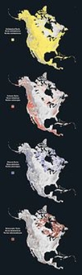
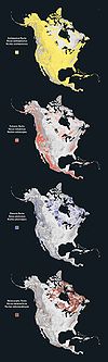
Geologic provinces
The lower 48 U.S. states can be divided into roughly five physiographic provinces:- The American cordilleraAmerican cordilleraThe American Cordillera is a cordillera that consists of an essentially continuous sequence of mountain ranges that form the western "backbone" of North America, Central America, South America and Antarctica. From north to south, this sequence of overlapping and parallel ranges begins with the...
. - The Canadian ShieldCanadian ShieldThe Canadian Shield, also called the Laurentian Plateau, or Bouclier Canadien , is a vast geological shield covered by a thin layer of soil that forms the nucleus of the North American or Laurentia craton. It is an area mostly composed of igneous rock which relates to its long volcanic history...
. - The stable platform.
- The coastal plain.
- The Appalachian orogenicOrogenyOrogeny refers to forces and events leading to a severe structural deformation of the Earth's crust due to the engagement of tectonic plates. Response to such engagement results in the formation of long tracts of highly deformed rock called orogens or orogenic belts...
belt.
The geology of Alaska
Alaska
Alaska is the largest state in the United States by area. It is situated in the northwest extremity of the North American continent, with Canada to the east, the Arctic Ocean to the north, and the Pacific Ocean to the west and south, with Russia further west across the Bering Strait...
is typical of that of the cordillera, while the major islands of Hawaii
Hawaii
Hawaii is the newest of the 50 U.S. states , and is the only U.S. state made up entirely of islands. It is the northernmost island group in Polynesia, occupying most of an archipelago in the central Pacific Ocean, southwest of the continental United States, southeast of Japan, and northeast of...
consist of Neogene
Neogene
The Neogene is a geologic period and system in the International Commission on Stratigraphy Geologic Timescale starting 23.03 ± 0.05 million years ago and ending 2.588 million years ago...
volcanics
Volcano
2. Bedrock3. Conduit 4. Base5. Sill6. Dike7. Layers of ash emitted by the volcano8. Flank| 9. Layers of lava emitted by the volcano10. Throat11. Parasitic cone12. Lava flow13. Vent14. Crater15...
erupted over a hot spot
Hotspot (geology)
The places known as hotspots or hot spots in geology are volcanic regions thought to be fed by underlying mantle that is anomalously hot compared with the mantle elsewhere. They may be on, near to, or far from tectonic plate boundaries. There are two hypotheses to explain them...
.

Great Plains
The Great Plains are a broad expanse of flat land, much of it covered in prairie, steppe and grassland, which lies west of the Mississippi River and east of the Rocky Mountains in the United States and Canada. This area covers parts of the U.S...
westward to the Pacific Ocean
Pacific Ocean
The Pacific Ocean is the largest of the Earth's oceanic divisions. It extends from the Arctic in the north to the Southern Ocean in the south, bounded by Asia and Australia in the west, and the Americas in the east.At 165.2 million square kilometres in area, this largest division of the World...
, narrowing somewhat from north to south. It includes the Cascades, Sierra Nevada, and Basin and Range
Basin and Range
The Basin and Range Province is a vast physiographic region defined by a unique topographic expression. Basin and Range topography is characterized by abrupt changes in elevation, alternating between narrow faulted mountain chains and flat arid valleys or basins...
province; the Rocky Mountains
Rocky Mountains
The Rocky Mountains are a major mountain range in western North America. The Rocky Mountains stretch more than from the northernmost part of British Columbia, in western Canada, to New Mexico, in the southwestern United States...
are sometimes excluded from the cordillera proper, in spite of their tectonic history. The geology of this region is complex, having gone through numerous orogenies, with their associated deformation, faulting, volcanic
Volcano
2. Bedrock3. Conduit 4. Base5. Sill6. Dike7. Layers of ash emitted by the volcano8. Flank| 9. Layers of lava emitted by the volcano10. Throat11. Parasitic cone12. Lava flow13. Vent14. Crater15...
activity, and periods of uplift separated by intervals of erosion. Much of the cordillera consists of terrane
Terrane
A terrane in geology is short-hand term for a tectonostratigraphic terrane, which is a fragment of crustal material formed on, or broken off from, one tectonic plate and accreted or "sutured" to crust lying on another plate...
s, ancient microcontinents and island arc
Island arc
An island arc is a type of archipelago composed of a chain of volcanoes which alignment is arc-shaped, and which are situated parallel and close to a boundary between two converging tectonic plates....
s that were "welded" onto the North American craton during the Paleozoic
Paleozoic
The Paleozoic era is the earliest of three geologic eras of the Phanerozoic eon, spanning from roughly...
and Mesozoic
Mesozoic
The Mesozoic era is an interval of geological time from about 250 million years ago to about 65 million years ago. It is often referred to as the age of reptiles because reptiles, namely dinosaurs, were the dominant terrestrial and marine vertebrates of the time...
eras. Such a convoluted history is typical of convergent plate boundaries, as has characterized the cordillera through most of the Phanerozoic
Phanerozoic
The Phanerozoic Eon is the current eon in the geologic timescale, and the one during which abundant animal life has existed. It covers roughly 542 million years and goes back to the time when diverse hard-shelled animals first appeared...
. Although the Colorado Plateau
Colorado Plateau
The Colorado Plateau, also called the Colorado Plateau Province, is a physiographic region of the Intermontane Plateaus, roughly centered on the Four Corners region of the southwestern United States. The province covers an area of 337,000 km2 within western Colorado, northwestern New Mexico,...
is near the cordillera, it has remained tectonically stable, with little deformation.
The Canadian Shield
Canadian Shield
The Canadian Shield, also called the Laurentian Plateau, or Bouclier Canadien , is a vast geological shield covered by a thin layer of soil that forms the nucleus of the North American or Laurentia craton. It is an area mostly composed of igneous rock which relates to its long volcanic history...
consists of surficial, deeply eroded Precambrian
Precambrian
The Precambrian is the name which describes the large span of time in Earth's history before the current Phanerozoic Eon, and is a Supereon divided into several eons of the geologic time scale...
rocks, exhumed by past glaciations. Consisting of a variety of rocks from igneous to ancient sedimentary, it is well-exposed only in the Great Lakes
Great Lakes
The Great Lakes are a collection of freshwater lakes located in northeastern North America, on the Canada – United States border. Consisting of Lakes Superior, Michigan, Huron, Erie, and Ontario, they form the largest group of freshwater lakes on Earth by total surface, coming in second by volume...
region.
A large part of the center of the lower 48 consists of the stable (or continental) platform. Here, the Precambrian rocks of the Shield are buried beneath sedimentary Phanerozoic strata. Tectonic activity is minor to nonexistent, with occasional broad domes
Dome (geology)
In structural geology, a dome is a deformational feature consisting of symmetrically-dipping anticlines; their general outline on a geologic map is circular or oval...
and basins
Basin (geology)
A structural basin is a large-scale structural formation of rock strata formed by tectonic warping of previously flat lying strata. Structural basins are geological depressions, and are the inverse of domes. Some elongated structural basins are also known as synclines...
that reveal mild epeirogenic deformation.
The coastal plain extends from the southern tip of Texas
Texas
Texas is the second largest U.S. state by both area and population, and the largest state by area in the contiguous United States.The name, based on the Caddo word "Tejas" meaning "friends" or "allies", was applied by the Spanish to the Caddo themselves and to the region of their settlement in...
across the northern Gulf of Mexico
Gulf of Mexico
The Gulf of Mexico is a partially landlocked ocean basin largely surrounded by the North American continent and the island of Cuba. It is bounded on the northeast, north and northwest by the Gulf Coast of the United States, on the southwest and south by Mexico, and on the southeast by Cuba. In...
and into the Mississippi embayment
Mississippi embayment
The Mississippi Embayment is a physiographic feature in the south-central United States, part of the Mississippi Alluvial Plain. It is essentially a northward continuation of the fluvial sediments of the Mississippi River Delta to its confluence with the Ohio River at Cairo, Illinois. The embayment...
, and northeast through the Mid-Atlantic
Mid-Atlantic States
The Mid-Atlantic states, also called middle Atlantic states or simply the mid Atlantic, form a region of the United States generally located between New England and the South...
states. A classic passive continental margin
Continental margin
The continental margin is the zone of the ocean floor that separates the thin oceanic crust from thick continental crust. Continental margins constitute about 28% of the oceanic area....
, it consists of a deep clastic wedge
Clastic wedge
In geology, clastic wedge usually refers to a thick assemblage of sediments--often lens-shaped in profile--eroded and deposited landward of a mountain chain; they begin at the mountain front, thicken considerably landwards of it to a peak depth, and progressively thin with increasing distance inland...
of sediment eroded from the platform and mountain belts; it first formed during the opening of the Atlantic Ocean
Atlantic Ocean
The Atlantic Ocean is the second-largest of the world's oceanic divisions. With a total area of about , it covers approximately 20% of the Earth's surface and about 26% of its water surface area...
and Gulf of Mexico during the Jurassic
Jurassic
The Jurassic is a geologic period and system that extends from about Mya to Mya, that is, from the end of the Triassic to the beginning of the Cretaceous. The Jurassic constitutes the middle period of the Mesozoic era, also known as the age of reptiles. The start of the period is marked by...
and Cretaceous
Cretaceous
The Cretaceous , derived from the Latin "creta" , usually abbreviated K for its German translation Kreide , is a geologic period and system from circa to million years ago. In the geologic timescale, the Cretaceous follows the Jurassic period and is followed by the Paleogene period of the...
periods.
The Appalachian orogenic belt extends from well into New England
New England
New England is a region in the northeastern corner of the United States consisting of the six states of Maine, New Hampshire, Vermont, Massachusetts, Rhode Island, and Connecticut...
south into Mississippi
Mississippi
Mississippi is a U.S. state located in the Southern United States. Jackson is the state capital and largest city. The name of the state derives from the Mississippi River, which flows along its western boundary, whose name comes from the Ojibwe word misi-ziibi...
and Alabama
Alabama
Alabama is a state located in the southeastern region of the United States. It is bordered by Tennessee to the north, Georgia to the east, Florida and the Gulf of Mexico to the south, and Mississippi to the west. Alabama ranks 30th in total land area and ranks second in the size of its inland...
. The Ouachita Mountains
Ouachita Mountains
The Ouachita Mountains are a mountain range in west central Arkansas and southeastern Oklahoma. The range's subterranean roots may extend as far as central Texas, or beyond it to the current location of the Marathon Uplift. Along with the Ozark Mountains, the Ouachita Mountains form the U.S...
of Arkansas
Arkansas
Arkansas is a state located in the southern region of the United States. Its name is an Algonquian name of the Quapaw Indians. Arkansas shares borders with six states , and its eastern border is largely defined by the Mississippi River...
, and even the Marathon Uplift
Marathon Uplift
The Marathon Uplift is a Tertiary-age domal uplift, approximately in diameter, in southwest Texas. The Marathon Basin was created by erosion of Cretaceous and younger strata from the crest of the uplift...
of Texas are also part of the same province, having all formed in the Alleghenian orogeny
Alleghenian orogeny
The Alleghenian orogeny or Appalachian orogeny is one of the geological mountain-forming events that formed the Appalachian Mountains and Allegheny Mountains. The term and spelling Alleghany orogeny was originally proposed by H.P. Woodward in 1957....
that took place when Pangea assembled during the late Paleozoic. Once lofty, they have been heavily weathered since the opening of the Atlantic Ocean. The Appalachians proper consist of deformed sedimentary rocks, cut through by numerous thrust faults; as in the western cordillera, the Appalachians experienced several orogenies over the course of the Paleozoic, making their geologic history difficult to interpret.
Geology of the Rocky Mountains
- Burgess ShaleBurgess ShaleThe Burgess Shale Formation, located in the Canadian Rockies of British Columbia, is one of the world's most celebrated fossil fields, and the best of its kind. It is famous for the exceptional preservation of the soft parts of its fossils...
- Cloverly FormationCloverly FormationThe Cloverly Formation are Lower Cretaceous strata located in Montana and Wyoming, in the western United States. The term now includes strata that had formerly been called the Dakota Formation in central and southern Wyoming.-Members:...
- Columbia IcefieldColumbia IcefieldThe Columbia Icefield is an icefield located in the Canadian Rockies, astride the Continental Divide of North America. The icefield lies partly in the northwestern tip of Banff National Park and the southern end of Jasper National Park. It is about 325 km² in area, 100 to 365 metres in depth and...
- Dakota HogbackDakota HogbackThe Dakota Hogback is a long hogback ridge at the eastern fringe of the Rocky Mountains that extends north-south from southern Wyoming through Colorado and into northern New Mexico in the United States. The ridge is prominently visible as the first line of foothills along the edge of the Great Plains...
- Dakota SandstoneDakota SandstoneThe Dakota Sandstone is a general term for an ill-defined early Cretaceous formation of the Rocky Mountains and Great Plains. It consists of sandy, shallow-marine deposits with intermittent mud flat sediments, and occasional stream deposits...
- Denver BasinDenver BasinThe Denver Basin, sometimes also called the Julesburg Basin, Denver-Julesburg Basin , or the D-J Basin, is a geologic structural basin centered in eastern Colorado in the United States, but extending into southeast Wyoming, western Nebraska, and western Kansas...
- Geology of the Grand Teton areaGeology of the Grand Teton areaThe geology of the Grand Teton area consists of some of the oldest rocks and one of the youngest mountain ranges in North America. The Teton Range, mostly located in Grand Teton National Park, started to grow some 9 million years ago...
- Gold mining in ColoradoGold mining in ColoradoOn 1859-05-06, John H. Gregory found a gold-bearing vein in Gregory Gulch between Black Hawk and Central City. Within two months many other veins were discovered, including the Bates, Gunnell, Kansas, and Burroughs...
- Grand MesaGrand MesaThe Grand Mesa is a large mesa in western Colorado in the United States. It has an area of about and stretches for about east of Grand Junction between the Colorado River and the Gunnison River, its tributary to the south. The north side of the mesa is drained largely by Plateau Creek, a...
- Great Divide BasinGreat Divide BasinThe Great Divide Basin is a drainage basin of the Continental Divide of the Americas. The basin is between the Green River watershed on the west and the Medicine Bow River watershed on the east . From the northwest, the basin begins in the "Wind River Range .....
- Green River FormationGreen River FormationThe Green River Formation is an Eocene geologic formation that records the sedimentation in a group of intermountain lakes. The sediments are deposited in very fine layers, a dark layer during the growing season and a light-hue inorganic layer in winter. Each pair of layers is called a varve and...
- La Garita CalderaLa Garita CalderaLa Garita Caldera is a large volcanic caldera located in the San Juan volcanic field in the San Juan Mountains near the town of Creede in southwestern Colorado, United States. It lies to the west of the town of La Garita, Colorado...
- Lance FormationLance FormationThe Lance Formation is a division of Late Cretaceous rocks in the western United States. Named after Lance Creek, Wyoming, the microvertebrate fossils and dinosaurs represent important components of the latest Mesozoic vertebrate faunas...
- Laramide orogenyLaramide orogenyThe Laramide orogeny was a period of mountain building in western North America, which started in the Late Cretaceous, 70 to 80 million years ago, and ended 35 to 55 million years ago. The exact duration and ages of beginning and end of the orogeny are in dispute, as is the cause. The Laramide...
- Morrison FormationMorrison FormationThe Morrison Formation is a distinctive sequence of Late Jurassic sedimentary rock that is found in the western United States, which has been the most fertile source of dinosaur fossils in North America. It is composed of mudstone, sandstone, siltstone and limestone and is light grey, greenish...
- Pikes Peak granitePikes Peak graniteThe Pikes Peak granite is a widespread geologic formation found in the central part of the Front Range of Colorado. The granite gets its name from the mountain Pikes Peak, which is made up almost entirely of the distinctive, brick-red rock...
- Powder River BasinPowder River BasinThe Powder River Basin is a geologic region in southeast Montana and northeast Wyoming, about east to west and north to south, known for its coal deposits. The region supplies about 40 percent of coal in the United States. It is both a topographic drainage and geologic structural basin...
- Raton BasinRaton BasinThe Raton Basin is a geologic structural basin in southern Colorado and northern New Mexico. It takes its name from Raton Pass and the town of Raton, New Mexico. In extent, the basin is approximately east-west, and north-south, in Huerfano and Las Animas Counties, Colorado, and Colfax County,...
- Rocky Mountain Association of GeologistsRocky Mountain Association of GeologistsThe Rocky Mountain Association of Geologists , based in Denver, Colorado, is one of the oldest and largest regional geological societies in the United States. The society is a nonprofit organization founded in 1922...
- Rocky Mountain TrenchRocky Mountain TrenchThe Rocky Mountain Trench, or the Trench or The Valley of a Thousand Peaks, is a large valley in the northern part of the Rocky Mountains. It is both visually and cartographically a striking physiographic feature extending approximately from Flathead Lake, Montana, to the Liard River, just south...
- Silver mining in ColoradoSilver mining in ColoradoSilver mining in Colorado, a state of the United States has taken place since the 1860s. In the past, Colorado called itself the Silver state...
- Sundance SeaSundance SeaThe Sundance Sea was an epeiric sea that existed in North America during the mid to late Jurassic Period of the Mesozoic Era. It was an arm of what is now the Arctic Ocean, and extended through what is now western Canada into the central western United States...
- Triple Divide PeakTriple Divide Peak (Montana)-See also:* Continental Divide of the Americas* Mountains and mountain ranges of Glacier National Park...
- Uranium mining in ColoradoUranium mining in ColoradoUranium mining in Colorado, United States, goes back to 1872, when pitchblende ore was taken from gold mines near Central City, Colorado. The Colorado uranium industry has seen booms and busts, but continues to this day...
- Uranium mining in WyomingUranium mining in WyomingUranium mining in Wyoming, a state of the United States was formerly a much larger industry than it is today. Wyoming once had many operating uranium mines, and still has the largest known uranium ore reserves of any state in the U.S. The Wyoming uranium mining industry was hard-hit in the 1980s...
- Western Interior SeawayWestern Interior SeawayThe Western Interior Seaway, also called the Cretaceous Seaway, the Niobraran Sea, and the North American Inland Sea, was a huge inland sea that split the continent of North America into two halves, Laramidia and Appalachia, during most of the mid- and late-Cretaceous Period...
Seismic faults
- Basin and Range Province
- Clarendon-Linden fault systemClarendon-Linden fault systemThe Clarendon-Linden fault system is a major series of fault lines in western New York state, in the United States. It extends through Orleans, Genesee, Wyoming, and into Allegany counties and is responsible for much of the seismic activity in the region....
- Humboldt faultHumboldt FaultThe Humboldt Fault or Humboldt Fault Zone, is a normal fault or series of faults, that extends from Nebraska southwestwardly through most of Kansas....
- Moab FaultMoab FaultThe Moab Fault, near Moab, Utah, USA is a well exposed and much studied geological fault. The Moab fault is an extensional fault that runs approximately NW-SE, passing to the west of the Arches National Park...
- New Madrid Seismic ZoneNew Madrid Seismic ZoneThe New Madrid Seismic Zone , sometimes called the New Madrid Fault Line, is a major seismic zone and a prolific source of intraplate earthquakes in the southern and midwestern United States, stretching to the southwest from New Madrid, Missouri.The New Madrid fault system was responsible for the...
- Seattle FaultSeattle FaultThe Seattle Fault is a zone of multiple shallow east-west thrust faults that cross the Puget Sound Lowland and through Seattle in the vicinity of Interstate Highway 90...
- Wasatch FaultWasatch FaultThe Wasatch Fault is an earthquake fault located primarily on the western edge of the Wasatch Mountains in the U.S. state of Utah. The fault is 240 miles long, stretching from southern Idaho, through northern Utah, before terminating in central Utah near the town of Fayette...
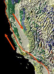
Faults in California
- Calaveras FaultCalaveras FaultThe Calaveras Fault is a major branch of the San Andreas Fault located in northern California in the San Francisco Bay Area. To the east of the Hayward-Rodgers Creek fault, the Calaveras fault extends 123 km, splaying from the San Andreas fault near Hollister and terminating at Danville at its...
- Clayton-Marsh Creek-Greenville FaultClayton-Marsh Creek-Greenville FaultThe Clayton-Marsh Creek-Greenville Fault is a fault located in the eastern San Francisco Bay Area of California, in Alameda County and Contra Costa County.It is part of the somewhat parallel system of faults that are secondary to the San Andreas Fault...
- Elsinore Fault ZoneElsinore Fault ZoneThe Elsinore Fault Zone is a large right-lateral strike-slip geological fault structure in Southern California. The fault is part of the trilateral split of the San Andreas fault system and is one of the largest, though quietest faults in Southern California....
- Garlock FaultGarlock FaultThe Garlock Fault is a left-lateral strike-slip fault running approximately northeast-southwest in the Mojave Desert of southern California. It runs for much of its length along the southern base of the Tehachapi Mountains...
- Hayward Fault ZoneHayward Fault ZoneThe Hayward Fault Zone is a geologic fault zone capable of generating significantly destructive earthquakes. This strike-slip fault is about long, situated mainly along the western base of the hills on the east side of San Francisco Bay...
- Healdsburg FaultHealdsburg FaultThe Healdsburg Fault is a seismically active geological feature associated with the Santa Rosa Plain and the Alexander Valley, in Sonoma County, California, USA. The eastern sides of these floodplains are bounded by strike-slip or transform faults...
- Mendocino Fracture ZoneMendocino Fracture ZoneThe Mendocino Fracture Zone is a fracture zone and transform boundary off the coast of Cape Mendocino in far northern California. It runs westward from a triple junction with the San Andreas Fault and the Cascadia subduction zone to the southern end of the Gorda Ridge...
- Monta Vista FaultMonta Vista FaultThe Monta Vista Fault is a potentially active geologic fault, i.e., a fault capable of generating destructive earthquakes, in Santa Clara County, California, USA...
- Newport-Inglewood FaultNewport-Inglewood FaultThe Newport-Inglewood Fault is a right-lateral fault in Southern California. The fault extends for from Culver City southeast to Newport Beach at which point it runs out into the Pacific Ocean. The fault can be seen on the Earth's surface as line of hills extending from Signal Hill to Culver City...
- Raymond FaultRaymond FaultThe Raymond Fault is a fault across central Los Angeles County and western Ventura County in Southern California.-San Gabriel Valley area:The eastern end of the Raymond Fault branches from the San Andreas Fault in the San Gabriel Mountains where it forms the east fork of the San Gabriel River and...
- San Andreas FaultSan Andreas FaultThe San Andreas Fault is a continental strike-slip fault that runs a length of roughly through California in the United States. The fault's motion is right-lateral strike-slip...
- San Gabriel FaultSan Gabriel FaultThe San Gabriel Fault is a geological fault in Los Angeles County, California, running about southeastward from the Ridge Basin in the Sierra Pelona-San Emigdio Mountains juncture area to the western San Gabriel Mountains that forms their southwestern face near Sunland and the northeastern San...
- San Jacinto Fault ZoneSan Jacinto Fault ZoneThe San Jacinto Fault Zone is a major fault zone in Southern California. It runs for through San Bernardino, Riverside, San Diego and Imperial Counties. It is considered to be the most seismically active fault zone in Southern California...
- Sierra Nevada FaultSierra Nevada FaultThe Sierra Nevada Fault is a normal seismic fault along the eastern edge of the Sierra Nevada mountain block in California. It also demarcates the western margin of the Basin and Range geologic province. Activity on this fault is responsible for the continuing uplift of the Sierra Nevada. ...
- Silver Creek FaultSilver Creek FaultThe Silver Creek Fault is a potentially seismically active northwest-southeast trending geological fault structure in Santa Clara County, California...
- Tesla FaultTesla FaultThe Tesla Fault is a seismically active geological fault structure associated with the Diablo Range in the vicinity of the Livermore Valley in Contra Costa County, California.-Geology:...
- White Wolf FaultWhite Wolf FaultThe White Wolf Fault is a fault in southern California, located north of the intersection of the San Andreas Fault and the Garlock Fault, and north of the Tehachapi Mountains. It is classed as a reverse fault with a left lateral component...
- Whittier FaultWhittier FaultThe Whittier Fault is a geologic fault located in eastern Los Angeles County in Southern California, that is one of the two upper branches of the Elsinore Fault Zone, with the Chino Fault the second.-Geology:...
Mines
- :Category: Coal mines in the United States
- :Category:Copper mines in the United States
- :Category:Diamond mines in the United States
- :Category: Gold mines in the United States
- :Category:Iron mines in the United States
- :Category:Mercury mines in the United States
- :Category:Quarries in the United States
- :Category:Silver mines in the United States
- :Category:Sulfur mines in the United States
- :Category:Zinc mines in the United States
Geology of U.S. states
- Geology of AlabamaGeology of AlabamaThe geology of Alabama is marked by abundant geologic resources and a variety of geologic structures from folded mountains in the north to sandy beaches along the Gulf of Mexico coast. Alabama spans three continental geologic provinces as defined by the United States Geological Survey, the Atlantic...
- Geology of ConnecticutGeology of ConnecticutAs part of New England, Connecticut has undergone much geologic change shaped by plate tectonics, volcanism, and glacial activity.-Appalachian Mountains:...
- Geology of DelawareGeology of DelawareThe geology of Delaware consists of two physiographic provinces. They are the Atlantic Coastal Plain Province and the Piedmont Province.-Coastal plain:...
- Geology of FloridaGeology of FloridaDuring the early Mesozoic Era the supercontinent of Pangea began to rift and break apart. As North America separated from Africa a small portion of the African plate detached and was carried away with the North American plate. This provided some of the foundation upon which Florida now rests. ...
- Geology of GeorgiaGeology of Georgia (U.S. state)The Geology of Georgia consists of four distinct geologic regions, beginning in the northwest corner of the state and moving through the state to the southeast: the Ridge and Valley, the Blue Ridge, the Piedmont and the Coastal Plain.-Ridge and Valley:...
- Geology of IdahoGeology of IdahoThe Geology of Idaho is complex, with outcroppings of differing ages of volcanics, undifferentiated metamorphics and sedimentary structures.-Idaho Geologic Survey:...
- Geology of IllinoisGeology of IllinoisThe strata of the bedrock geology of Illinois are dominated by Pennsylvanian age rocks which occur within the Illinois Basin.- Illinois Basin :...
- Geology of IowaIowa geologyThis article is about Iowa geology. For the study of buried human cultural remains in Iowa, see Iowa archaeology.The geology of Iowa includes the study of bedrock, landforms, geography, and paleontology of the state of Iowa.-Notable Iowa geologists:...
- Geology of KansasGeology of KansasThe Geology of Kansas encompasses the geologic history of the US state of Kansas and the present-day rock and soil that is exposed there. Rock that crops out in Kansas was formed during the Phanerozoic eon, which consists of three geologic eras: the Paleozoic, Mesozoic and Cenozoic...
- Geology of Massachusetts
- Geology of Minnesota
- Geology of New JerseyGeology of New JerseyThe Geology of New Jersey consists of four distinct physiographic provinces. They are: the Atlantic Coastal Plain Province, the Piedmont Province, the Highlands Province, and the Ridge and Valley Province.-Coastal Plain:...
- Geology of OklahomaGeology of OklahomaThe geology of Oklahoma is characterized by Carboniferous rocks in the east, Permian rocks in the center and towards the west, and a cover of Tertiary deposits in the pan handle to the west. Cretaceous sediments are found in the south east. There are also some areas with older outcrops dating back...
- Geology of Oregon
- Geology of PennsylvaniaGeology of PennsylvaniaThe Geology of Pennsylvania consists of six distinct physiographic provinces, three of which are subdivided into different sections. Each province has its own economic advantages and geologic hazards and play an important role in shaping everyday life in the state...
- Geology of TennesseeGeology of TennesseeThe geology of Tennessee is as diverse as its landscapes. Politically, Tennessee is broken up into three Grand Divisions: East, Middle, and West Tennessee...
- Geology of TexasGeology of TexasTexas contains a great variety of geologic settings. The state's stratigraphy has been largely influenced by marine transgressive-regressive cycles during the Phanerozoic, with a lesser but still significant contribution from late Cenozoic tectonic activity, as well as the remnants of a Paleozoic...
- Geology of West VirginiaGeology of West VirginiaPrior to one billion years ago, the geologic history of West Virginia is obscure. The oldest evidences of life found in West Virginia occur in rocks about 600 million years old, in the Antietam Formation of Lower Cambrian age. The oldest exposed rock, the Catoctin greenstone, began to form between...
See also
- Geology of the Pacific NorthwestGeology of the Pacific NorthwestThe geology of the Pacific Northwest refers to the study of the composition , structure, physical properties and the processes that shape the Pacific Northwest region of the United States and Canada...
- Geology of the Yosemite areaGeology of the Yosemite areaThe exposed geology of the Yosemite area includes primarily granitic rocks with some older metamorphic rock. The first rocks were laid down in Precambrian times, when the area around Yosemite National Park was on the edge of a very young North American continent...
- Absaroka sequenceAbsaroka sequenceThe Absaroka sequence was a cratonic sequence that extended from the end of the Mississippian through the Permian periods. It is the unconformity between this sequence and the preceding Kaskaskia that divides the Carboniferous into the Mississippian and Pennsylvanian periods in North America.Like...
- Acadian orogenyAcadian orogenyThe Taconic, Acadian and Alleghenian orogenies are the three tectonic phases responsible for the formation of the present Appalachian Mountains. The Acadian orogeny is a middle Paleozoic mountain building episode dating back 325-400 million years which should not be regarded as a single event but...
- Anadarko BasinAnadarko BasinThe Anadarko Basin is a geologic depositional and structural basin centered in the western part of the state of Oklahoma and the Texas Panhandle, and extending into western Kansas and southeast Colorado.-Geology:...
- Chazy FormationChazy FormationThe Chazy Reef Formation is a mid-Ordovician limestone deposit that consists of some of the oldest reef systems built by a community of organisms rather than the deposit of a limited range of similar organisms, such as Stromatolite mounds deposited by ancient cyanobacteria...
- :Category:Driftless Area
- Fjords of the United StatesFjords of the United StatesThe fjords of the United States exist mainly in the states of Washington and Alaska. These fjords — long and narrow inlets in valleys carved by glacial activity — can have two or more basins separated by sills...
- Fort Payne FormationFort Payne FormationThe Fort Payne Formation, or Fort Payne Chert, is a geologic formation found in the southeastern region of the United States. It is a Mississippian cherty limestone that overlies the Chattanooga Shale and underlies the St. Louis Limestone . To the north, it grades into the siltstone Borden Formation...
- Geological Exploration of the Fortieth ParallelGeological Exploration of the Fortieth ParallelThe Geological Exploration of the Fortieth Parallel was a geological survey made by order of the Secretary of War according to acts of Congress of March 2,1867, and March 3, 1869, under the direction of Brig. and Bvt. Major General A. A. Humphreys, Chief of Engineers, by Clarence King, U. S....
- Geology of the AppalachiansGeology of the AppalachiansThe geology of the Appalachians dates back to more than 480 million years ago. A look at rocks exposed in today's Appalachian Mountains reveals elongate belts of folded and thrust faulted marine sedimentary rocks, volcanic rocks and slivers of ancient ocean floor - strong evidence that these rocks...
- Geothermal features of Yellowstone
- Hawaiian IslandsHawaiian IslandsThe Hawaiian Islands are an archipelago of eight major islands, several atolls, numerous smaller islets, and undersea seamounts in the North Pacific Ocean, extending some 1,500 miles from the island of Hawaii in the south to northernmost Kure Atoll...
- Ice Age National Scientific ReserveIce Age National Scientific ReserveThe Ice Age National Scientific Reserve is a collection of nine sites in Wisconsin that preserve geological evidence of glaciation. The reserve was created in 1971 to protect the scientific and scenic value of the landforms...
- Laurentide ice sheetLaurentide ice sheetThe Laurentide Ice Sheet was a massive sheet of ice that covered hundreds of thousands of square miles, including most of Canada and a large portion of the northern United States, multiple times during Quaternary glacial epochs. It last covered most of northern North America between c. 95,000 and...
- Kaskaskia sequenceKaskaskia sequenceThe Kaskaskia sequence was a cratonic sequence that began in the mid-Devonian, peaked early in the Mississippian, and ended by mid-Mississippian time...
- Laramide orogenyLaramide orogenyThe Laramide orogeny was a period of mountain building in western North America, which started in the Late Cretaceous, 70 to 80 million years ago, and ended 35 to 55 million years ago. The exact duration and ages of beginning and end of the orogeny are in dispute, as is the cause. The Laramide...
- Meramec (series)Meramec (series)The Meramecian or Maramec stage is a sequence of Mississippian rocks in the Mississippi River Valley. It is named for the Meramec River in Missouri....
- Mountain peaks of North AmericaMountain peaks of North AmericaThis article comprises three sortable tables of major mountain peaks of greater North America.This article defines greater North America as the portion of the continental landmass of the Americas extending northward from Panama plus the islands surrounding that landmass...
- Queenston DeltaQueenston DeltaThe Queenston Delta is a 300-mile-wide clastic wedge of sediment deposited over what is now eastern North America during the late Ordovician period due to the erosion of mountains created during the Taconic orogeny. The wedge is thickest in a band running from New York State to Quebec....
- Ridge-and-valley AppalachiansRidge-and-valley AppalachiansThe Ridge-and-Valley Appalachians, also called the Ridge and Valley Province or the Valley and Ridge Appalachians, are a physiographic province of the larger Appalachian division and are also a belt within the Appalachian Mountains extending from southeastern New York through northwestern New...
- Sauk sequenceSauk sequenceThe Sauk sequence was the earliest of the six cratonic sequences that have occurred during the Phanerozoic...
- Sevier orogenySevier orogenyThe Sevier orogeny was a mountain-building event that affected western North America from Canada to the north to Mexico to the south. This orogeny was the result of convergent boundary tectonic activity between approximately 140 million years ago and 50 Ma. The Sevier River area of central Utah...
- St. Louis LimestoneSt. Louis LimestoneThe St. Louis Limestone is a large geologic formation covering a wide area of the midwest of the United States. It is named after an exposure at St. Louis, Missouri. It consists of sedimentary limestone with scattered chert beds, including the heavily chertified Lost River Chert Bed in the Horse...
- Ste. Genevieve LimestoneSte. Genevieve LimestoneThe Ste. Genevieve Limestone is a geologic formation named for Ste. Genevieve, Missouri where it is exposed and was first described. It is a thick-bedded limestone that overlies the St. Louis Limestone. Both are Mississippian in age and part of the Meramecian series.Members of the Ste...
- Taconic orogenyTaconic orogenyThe Taconic orogeny was a mountain building period that ended 440 million years ago and affected most of modern-day New England. A great mountain chain formed from eastern Canada down through what is now the Piedmont of the East coast of the United States...
- Tejas sequenceTejas sequenceThe Tejas sequence was the last major marine transgression across the North American craton. Following the late Cretaceous regression that ended the Zuñi sequence, the oceans advanced again early in the Cenozoic, peaking during the Paleocene and Eocene epochs...
- Tippecanoe sequenceTippecanoe sequenceThe Tippecanoe sequence was the cratonic sequence--that is, the marine transgression--that followed the Sauk sequence; it extended from roughly the middle Ordovician to the early Devonian.-Sedimentary characteristics:...
- Western Interior SeawayWestern Interior SeawayThe Western Interior Seaway, also called the Cretaceous Seaway, the Niobraran Sea, and the North American Inland Sea, was a huge inland sea that split the continent of North America into two halves, Laramidia and Appalachia, during most of the mid- and late-Cretaceous Period...
- Zuñi sequenceZuñi sequenceThe Zuñi sequence was the major cratonic sequence after the Absaroka sequence that began in the latest Jurassic, peaked in the late Cretaceous, and ended by the start of the following Paleocene...