

Mountain peaks of North America
Encyclopedia
Summit (topography)
In topography, a summit is a point on a surface that is higher in elevation than all points immediately adjacent to it. Mathematically, a summit is a local maximum in elevation...
of greater North America
North America
North America is a continent wholly within the Northern Hemisphere and almost wholly within the Western Hemisphere. It is also considered a northern subcontinent of the Americas...
.
This article defines greater North America as the portion of the continental landmass of the Americas
Americas
The Americas, or America , are lands in the Western hemisphere, also known as the New World. In English, the plural form the Americas is often used to refer to the landmasses of North America and South America with their associated islands and regions, while the singular form America is primarily...
extending northward from Panama
Panama
Panama , officially the Republic of Panama , is the southernmost country of Central America. Situated on the isthmus connecting North and South America, it is bordered by Costa Rica to the northwest, Colombia to the southeast, the Caribbean Sea to the north and the Pacific Ocean to the south. The...
plus the islands surrounding that landmass. This article defines the islands of North America to include the coastal islands of North America, the islands of the Caribbean Sea
Caribbean Sea
The Caribbean Sea is a sea of the Atlantic Ocean located in the tropics of the Western hemisphere. It is bounded by Mexico and Central America to the west and southwest, to the north by the Greater Antilles, and to the east by the Lesser Antilles....
, the Lucayan Archipelago
Lucayan archipelago
The Lucayan Archipelago, as defined by Julian Granberry, consists of the islands of the Commonwealth of the Bahamas and of the Turks and Caicos Islands...
, the Bermuda Islands, the Islands of Greenland (Kalaallit Nunaat), the islands of Northern Canada
Northern Canada
Northern Canada, colloquially the North, is the vast northernmost region of Canada variously defined by geography and politics. Politically, the term refers to the three territories of Canada: Yukon, Northwest Territories, and Nunavut...
, the islands of Alaska
Alaska
Alaska is the largest state in the United States by area. It is situated in the northwest extremity of the North American continent, with Canada to the east, the Arctic Ocean to the north, and the Pacific Ocean to the west and south, with Russia further west across the Bering Strait...
, and the islands of the northeastern Pacific Ocean
Pacific Ocean
The Pacific Ocean is the largest of the Earth's oceanic divisions. It extends from the Arctic in the north to the Southern Ocean in the south, bounded by Asia and Australia in the west, and the Americas in the east.At 165.2 million square kilometres in area, this largest division of the World...
. The Hawaiian Islands
Hawaiian Islands
The Hawaiian Islands are an archipelago of eight major islands, several atolls, numerous smaller islets, and undersea seamounts in the North Pacific Ocean, extending some 1,500 miles from the island of Hawaii in the south to northernmost Kure Atoll...
are not included because they are considered part of Oceania
Oceania
Oceania is a region centered on the islands of the tropical Pacific Ocean. Conceptions of what constitutes Oceania range from the coral atolls and volcanic islands of the South Pacific to the entire insular region between Asia and the Americas, including Australasia and the Malay Archipelago...
.
Topographic elevation is the vertical distance above the reference geoid
Geoid
The geoid is that equipotential surface which would coincide exactly with the mean ocean surface of the Earth, if the oceans were in equilibrium, at rest , and extended through the continents . According to C.F...
, a precise mathematical model of the Earth's sea level
Sea level
Mean sea level is a measure of the average height of the ocean's surface ; used as a standard in reckoning land elevation...
as an equipotential
Equipotential
Equipotential or isopotential in mathematics and physics refers to a region in space where every point in it is at the same potential. This usually refers to a scalar potential , although it can also be applied to vector potentials...
gravitational surface. Topographic prominence
Topographic prominence
In topography, prominence, also known as autonomous height, relative height, shoulder drop , or prime factor , categorizes the height of the mountain's or hill's summit by the elevation between it and the lowest contour line encircling it and no higher summit...
is the elevation difference between the summit and the highest or key col to a higher summit. Topographic isolation
Topographic isolation
The topographic isolation of a summit is the minimum horizontal distance to the nearest point of higher elevation. Topographic isolation represents a radius of dominance in which the summit is the highest point. Topographic isolation can be calculated for small hills and islands as well as for...
is the minimum great circle
Great circle
A great circle, also known as a Riemannian circle, of a sphere is the intersection of the sphere and a plane which passes through the center point of the sphere, as opposed to a general circle of a sphere where the plane is not required to pass through the center...
distance to a point of higher elevation.
This article defines a significant summit as a summit with at least 100 meters (328.1 feet) of topographic prominence, and a major summit as a summit with at least 500 meters (1640.4 feet) of topographic prominence. An ultra-prominent summit is a summit with at least 1500 meters (4921.3 feet) of topographic prominence. There are 356 ultra-prominent summits in greater North America.
All elevations in the 48 states
U.S. state
A U.S. state is any one of the 50 federated states of the United States of America that share sovereignty with the federal government. Because of this shared sovereignty, an American is a citizen both of the federal entity and of his or her state of domicile. Four states use the official title of...
of the contiguous United States
Contiguous United States
The contiguous United States are the 48 U.S. states on the continent of North America that are south of Canada and north of Mexico, plus the District of Columbia....
include an elevation adjustment from the National Geodetic Vertical Datum of 1929 (NGVD 29) to the North American Vertical Datum of 1988
North American Vertical Datum of 1988
The North American Vertical Datum of 1988 is the vertical control datum of orthometric height established for vertical control surveying in the United States of America based upon the General Adjustment of the North American Datum of 1988....
(NAVD 88). For further information, please see this United States National Geodetic Survey note. If a summit elevation or prominence has a range of values, the arithmetic mean is cited.
Highest major summits
The following sortable table lists the 20 highest mountain peaks of greater North America with at least 500 meters (1640.4 feet) of topographic prominence.| Rank Ranking A ranking is a relationship between a set of items such that, for any two items, the first is either 'ranked higher than', 'ranked lower than' or 'ranked equal to' the second.... |
Mountain Peak Summit (topography) In topography, a summit is a point on a surface that is higher in elevation than all points immediately adjacent to it. Mathematically, a summit is a local maximum in elevation... |
Region Region Region is most commonly found as a term used in terrestrial and astrophysics sciences also an area, notably among the different sub-disciplines of geography, studied by regional geographers. Regions consist of subregions that contain clusters of like areas that are distinctive by their uniformity... |
Mountain Range Mountain range A mountain range is a single, large mass consisting of a succession of mountains or narrowly spaced mountain ridges, with or without peaks, closely related in position, direction, formation, and age; a component part of a mountain system or of a mountain chain... |
Elevation | Prominence Topographic prominence In topography, prominence, also known as autonomous height, relative height, shoulder drop , or prime factor , categorizes the height of the mountain's or hill's summit by the elevation between it and the lowest contour line encircling it and no higher summit... |
Isolation Topographic isolation The topographic isolation of a summit is the minimum horizontal distance to the nearest point of higher elevation. Topographic isolation represents a radius of dominance in which the summit is the highest point. Topographic isolation can be calculated for small hills and islands as well as for... |
Location Geographic coordinate system A geographic coordinate system is a coordinate system that enables every location on the Earth to be specified by a set of numbers. The coordinates are often chosen such that one of the numbers represent vertical position, and two or three of the numbers represent horizontal position... |
|---|---|---|
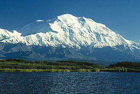
| 1 |
 Alaska Alaska |
63.0690°N 151.0063°W |
| 2 |
 Yukon Yukon |
60.5666°N 140.4072°W |
| 3 |
 Puebla Puebla Veracruz Veracruz |
19.0305°N 97.2698°W |
| 4 |
Alaska Yukon |
60.2927°N 140.9307°W |
| 5 |
 Morelos Puebla Morelos Puebla |
19.0225°N 98.6278°W |
| 6 |
Alaska |
62.9605°N 151.3992°W |
| 7 |
Yukon |
61.0215°N 140.4661°W |
| 8 |
Puebla |
19.1792°N 98.6419°W |
| 9 |
Yukon |
60.5834°N 140.6561°W |
| 10 |
Alaska |
61.3845°N 141.7529°W |
| 11 |
Yukon |
61.0929°N 140.3118°W |
| 12 |
Alaska |
61.7305°N 143.4031°W |
| 13 |
Alaska |
62.2132°N 144.1292°W |
| 14 |
Yukon |
61.2323°N 140.5139°W |
| 15 |
Yukon |
60.3589°N 139.6980°W |
| 16 |
Yukon |
61.1723°N 140.5869°W |
| 17 |
19.1020°N 99.7676°W | |
| 18 |
Alaska British Columbia British Columbia |
58.9064°N 137.5265°W |
| 19 |
Alaska Yukon |
60.3194°N 139.0726°W |
| 20 |
Alaska |
61.2834°N 141.1433°W |
Most prominent summits
The following sortable table lists the 50 most topographically prominent mountain peaks of greater North America. Of these 50 most prominent summits, 27 are located in the United States, 19 in Canada, 3 in Mexico, and one each in Guatemala, Costa Rica, Greenland, the Dominican Republic, and Haiti. Four of these peaks lie on the international border between Canada and the United States.| Rank Ranking A ranking is a relationship between a set of items such that, for any two items, the first is either 'ranked higher than', 'ranked lower than' or 'ranked equal to' the second.... |
Mountain Peak Summit (topography) In topography, a summit is a point on a surface that is higher in elevation than all points immediately adjacent to it. Mathematically, a summit is a local maximum in elevation... |
Region Region Region is most commonly found as a term used in terrestrial and astrophysics sciences also an area, notably among the different sub-disciplines of geography, studied by regional geographers. Regions consist of subregions that contain clusters of like areas that are distinctive by their uniformity... |
Mountain Range Mountain range A mountain range is a single, large mass consisting of a succession of mountains or narrowly spaced mountain ridges, with or without peaks, closely related in position, direction, formation, and age; a component part of a mountain system or of a mountain chain... |
Elevation | Prominence Topographic prominence In topography, prominence, also known as autonomous height, relative height, shoulder drop , or prime factor , categorizes the height of the mountain's or hill's summit by the elevation between it and the lowest contour line encircling it and no higher summit... |
Isolation Topographic isolation The topographic isolation of a summit is the minimum horizontal distance to the nearest point of higher elevation. Topographic isolation represents a radius of dominance in which the summit is the highest point. Topographic isolation can be calculated for small hills and islands as well as for... |
Location Geographic coordinate system A geographic coordinate system is a coordinate system that enables every location on the Earth to be specified by a set of numbers. The coordinates are often chosen such that one of the numbers represent vertical position, and two or three of the numbers represent horizontal position... |
|---|---|---|
| 1 |
Alaska |
63.0690°N 151.0063°W |
| 2 |
Yukon |
60.5666°N 140.4072°W |
| 3 |
Puebla Veracruz |
19.0305°N 97.2698°W |
| 4 |
 Washington Washington |
46.8521°N 121.7579°W |
| 5 |
15.0445°N 91.9035°W | |
| 6 |
Alaska British Columbia |
58.9064°N 137.5265°W |
| 7 |
9.4841°N 83.4887°W | |
| 8 |
68.9186°N 29.8986°W | |
| 9 |
Alaska |
61.7305°N 143.4031°W |
| 10 |
Alaska |
63.6199°N 146.7174°W |
| 11 |
Alaska Yukon |
60.2927°N 140.9307°W |
| 12 |
British Columbia |
51.3737°N 125.2636°W |
| 13 |
Alaska |
61.4374°N 147.7525°W |
| 14 |
19.0230°N 70.9981°W | |
| 15 |
Yukon |
61.0215°N 140.4661°W |
| 16 |
 California California |
36.5786°N 118.2920°W |
| 17 |
Morelos Puebla |
19.0225°N 98.6278°W |
| 18 |
California |
41.4092°N 122.1949°W |
| 19 |
British Columbia |
51.8995°N 125.8760°W |
| 20 |
Alaska |
54.7554°N 163.9709°W |
| 21 |
British Columbia |
53.1105°N 119.1566°W |
| 22 |
Alaska |
60.4851°N 152.7439°W |
| 23 |
 Colorado Colorado |
39.1178°N 106.4454°W |
| 24 |
British Columbia |
52.8015°N 119.7315°W |
| 25 |
 Jalisco Jalisco |
19.5629°N 103.6083°W |
| 26 |
Yukon |
60.3589°N 139.6980°W |
| 27 |
British Columbia |
51.6566°N 117.8676°W |
| 28 |
Washington |
48.7768°N 121.8145°W |
| 29 |
18.3601°N 71.9764°W | |
| 30 |
Alaska |
61.4086°N 152.4125°W |
| 31 |
 Nunavut Nunavut |
81.9138°N 75.0116°W |
| 32 |
California |
33.8147°N 116.6794°W |
| 33 |
California |
34.0992°N 116.8249°W |
| 34 |
 Nevada Nevada |
36.2716°N 115.6956°W |
| 35 |
Alaska |
55.4175°N 161.8932°W |
| 36 |
Alaska |
56.2191°N 159.2980°W |
| 37 |
Washington |
46.2024°N 121.4909°W |
| 38 |
British Columbia |
50.1878°N 121.9032°W |
| 39 |
Alaska Yukon |
60.3194°N 139.0726°W |
| 40 |
British Columbia |
57.3930°N 132.3031°W |
| 41 |
Alaska |
69.2820°N 144.8996°W |
| 42 |
British Columbia |
50.5518°N 118.1293°W |
| 43 |
British Columbia |
52.3853°N 118.9399°W |
| 44 |
Alaska |
60.0321°N 153.0915°W |
| 45 |
Washington |
47.8013°N 123.7108°W |
| 46 |
 Alberta British Columbia Alberta British Columbia |
52.1473°N 117.4416°W |
| 47 |
British Columbia |
51.2714°N 124.5682°W |
| 48 |
Alaska Yukon |
60.1816°N 139.9811°W |
| 49 |
 Oregon Oregon |
45.3735°N 121.6959°W |
| 50 |
Alaska |
62.2132°N 144.1292°W |
Most isolated major summits
The following sortable table lists the 50 most topographically isolated mountain peaks of greater North America with at least 500 meters (1640.4 feet) of topographic prominence. Of these 50 most isolated major summits, 16 are located in Canada, 15 in the United States, 8 in Greenland, 5 in Mexico, and one each in the Dominican Republic, Costa Rica, Guatemala, Guadeloupe, Puerto Rico, and Cuba.| Rank Ranking A ranking is a relationship between a set of items such that, for any two items, the first is either 'ranked higher than', 'ranked lower than' or 'ranked equal to' the second.... |
Mountain Peak Mountain peak A mountain peak is the highest part of a mountain; a mountaintop; the summit.Mountain Peak may also refer to:* Blue Mountain Peak, Jamaica* Hole in the Mountain Peak, Nevada, USA... |
Region Region Region is most commonly found as a term used in terrestrial and astrophysics sciences also an area, notably among the different sub-disciplines of geography, studied by regional geographers. Regions consist of subregions that contain clusters of like areas that are distinctive by their uniformity... |
Mountain Range Mountain range A mountain range is a single, large mass consisting of a succession of mountains or narrowly spaced mountain ridges, with or without peaks, closely related in position, direction, formation, and age; a component part of a mountain system or of a mountain chain... |
Elevation | Prominence Topographic prominence In topography, prominence, also known as autonomous height, relative height, shoulder drop , or prime factor , categorizes the height of the mountain's or hill's summit by the elevation between it and the lowest contour line encircling it and no higher summit... |
Isolation Topographic isolation The topographic isolation of a summit is the minimum horizontal distance to the nearest point of higher elevation. Topographic isolation represents a radius of dominance in which the summit is the highest point. Topographic isolation can be calculated for small hills and islands as well as for... |
Location Geographic coordinate system A geographic coordinate system is a coordinate system that enables every location on the Earth to be specified by a set of numbers. The coordinates are often chosen such that one of the numbers represent vertical position, and two or three of the numbers represent horizontal position... |
|---|---|---|
| 1 |
Alaska |
63.0690°N 151.0063°W |
| 2 |
68.9186°N 29.8986°W | |
| 3 |
Puebla Veracruz |
19.0305°N 97.2698°W |
| 4 |
California |
36.5786°N 118.2920°W |
| 5 |
 North Carolina North Carolina |
35.7650°N 82.2652°W |
| 6 |
 New Hampshire New Hampshire |
44.2705°N 71.3032°W |
| 7 |
Washington |
46.8521°N 121.7579°W |
| 8 |
Colorado |
39.1178°N 106.4454°W |
| 9 |
19.0230°N 70.9981°W | |
| 10 |
Alaska |
54.7554°N 163.9709°W |
| 11 |
9.4841°N 83.4887°W | |
| 12 |
 Newfoundland and Labrador Newfoundland and Labrador |
58.8878°N 63.7098°W |
| 13 |
Nunavut |
81.9138°N 75.0116°W |
| 14 |
Nunavut |
72.1806°N 75.9111°W |
| 15 |
15.0445°N 91.9035°W | |
| 16 |
Nunavut |
75.3694°N 115.0827°W |
| 17 |
16.0446°N 61.6642°W | |
| 18 |
Alaska |
51.8833°N 178.1333°W |
| 19 |
Alaska |
69.2820°N 144.8996°W |
| 20 |
77.5000°N 47.6167°W | |
| 21 |
Nunavut |
64.7403°N 83.1573°W |
| 22 |
Yukon |
60.5666°N 140.4072°W |
| 23 |
 Arkansas Arkansas |
35.1670°N 93.6447°W |
| 24 |
Nunavut |
66.5468°N 65.4289°W |
| 25 |
 Nuevo León Nuevo León |
24.8719°N 100.2327°W |
| 26 |
British Columbia |
51.3737°N 125.2636°W |
| 27 |
Yukon |
63.4314°N 130.3243°W |
| 28 |
California |
41.4092°N 122.1949°W |
| 29 |
63.4333°N 44.6667°W | |
| 30 |
71.4000°N 51.9667°W | |
| 31 |
Newfoundland and Labrador |
53.6465°N 58.5536°W |
| 32 |
Newfoundland and Labrador |
48.8331°N 58.4843°W |
| 33 |
83.3000°N 35.3333°W | |
| 34 |
 Colima Colima |
18.8000°N 110.9833°W |
| 35 |
 Quebec Quebec |
52.3223°N 70.4451°W |
| 36 |
72.4667°N 37.1000°W | |
| 37 |
66.2000°N 52.3500°W | |
| 38 |
 Wyoming Wyoming |
43.1842°N 109.6542°W |
| 39 |
British Columbia |
53.1105°N 119.1566°W |
| 40 |
Alaska |
64.9922°N 165.3294°W |
| 41 |
Alaska |
67.4129°N 154.9656°W |
| 42 |
British Columbia |
57.3464°N 124.0928°W |
| 43 |
18.1722°N 66.5919°W | |
| 44 |
 Durango Durango |
23.2500°N 104.9500°W |
| 45 |
21.9853°N 80.1327°W | |
| 46 |
Jalisco |
19.5629°N 103.6083°W |
| 47 |
Quebec |
48.9884°N 65.9483°W |
| 48 |
 Arizona Arizona |
35.3463°N 111.6779°W |
| 49 |
76.4333°N 62.3000°W | |
| 50 |
Nunavut |
71.8528°N 112.6073°W |
See also
- North AmericaNorth AmericaNorth America is a continent wholly within the Northern Hemisphere and almost wholly within the Western Hemisphere. It is also considered a northern subcontinent of the Americas...
- Geography of North AmericaGeography of North AmericaNorth America is the third largest continent, or a portion of the second largest if North and South America are combined into the Americas and Africa, Europe and Asia are considered to be part of one supercontinent called Afro-Eurasia...
- :Category:Mountains of North America
- commons:Category:Mountains of North America
- :Category:Mountains of North America
- Geography of North America
- Physical geographyPhysical geographyPhysical geography is one of the two major subfields of geography. Physical geography is that branch of natural science which deals with the study of processes and patterns in the natural environment like the atmosphere, biosphere and geosphere, as opposed to the cultural or built environment, the...
- TopographyTopographyTopography is the study of Earth's surface shape and features or those ofplanets, moons, and asteroids...
- Topographic elevation
- Topographic isolationTopographic isolationThe topographic isolation of a summit is the minimum horizontal distance to the nearest point of higher elevation. Topographic isolation represents a radius of dominance in which the summit is the highest point. Topographic isolation can be calculated for small hills and islands as well as for...
- Topographic prominenceTopographic prominenceIn topography, prominence, also known as autonomous height, relative height, shoulder drop , or prime factor , categorizes the height of the mountain's or hill's summit by the elevation between it and the lowest contour line encircling it and no higher summit...
- Topographic summit
- Topography
- Lists of mountains
- Mountain peaks of greater North America
- The 200 highest major mountain peaks of greater North America
- The 124 4000 meter major mountain peaks of greater North America
- The 200 most topographically prominent mountain peaks of greater North America
- The 356 ultra-prominent mountain peaks of greater North America
- The 200 most topographically isolated major mountain peaks of greater North America
- The 234 100 km isolated major mountain peaks of greater North America
- Mountain peaks of GreenlandMountain peaks of GreenlandThis article comprises three sortable tables of major mountain peaks of Greenland. For this article, Greenland includes all of Kalaallit Nunaat including the Island of Greenland and surrounding islands....
- Mountain peaks of CanadaMountain peaks of CanadaThis article comprises three sortable tables of major mountain peaks of Canada.Topographic elevation is the vertical distance above the reference geoid, a precise mathematical model of the Earth's sea level as an equipotential gravitational surface. Topographic prominence is the elevation...
- Mountain peaks of the Rocky MountainsMountain peaks of the Rocky MountainsThis article comprises three sortable tables of major mountain peaks of the Rocky Mountains of North America.Topographic elevation is the vertical distance above the reference geoid, a precise mathematical model of the Earth's sea level as an equipotential gravitational surface...
- Mountain peaks of the United StatesMountain peaks of the United StatesThis article comprises three sortable tables of the major mountain peaks of the United States of America.Topographic elevation is the vertical distance above the reference geoid, a precise mathematical model of the Earth's sea level as an equipotential gravitational surface...
- Mountain peaks of AlaskaMountain peaks of AlaskaThis article comprises three sortable tables of mountain peaks of the U.S. State of Alaska.Topographic elevation is the vertical distance above the reference geoid, a precise mathematical model of the Earth's sea level as an equipotential gravitational surface. Topographic prominence is the...
- Mountain peaks of CaliforniaMountain peaks of CaliforniaThis article comprises three sortable tables of major mountain peaks of the U.S. State of California.Topographic elevation is the vertical distance above the reference geoid, a precise mathematical model of the Earth's sea level as an equipotential gravitational surface...
- Mountain peaks of ColoradoMountain peaks of ColoradoThis article comprises three sortable tables of the major mountain peaks of the U.S. State of Colorado.Topographic elevation is the vertical distance above the reference geoid, a precise mathematical model of the Earth's sea level as an equipotential gravitational surface...
- Mountain peaks of Alaska
- Mountain peaks of MéxicoMountain peaks of MexicoThis article comprises three sortable tables of the major mountain peaks of Mexico.Topographic elevation is the vertical distance above the reference geoid, a precise mathematical model of the Earth's sea level as an equipotential gravitational surface. Topographic prominence is the elevation...
- Mountain peaks of Central AmericaMountain peaks of Central AmericaThis article comprises three sortable tables of major mountain peaks of Central America. This article defines Central America as the seven nations of Belize, Costa Rica, El Salvador, Guatemala, Honduras, Nicaragua, and Panama....
- Mountain peaks of the CaribbeanMountain peaks of the CaribbeanThis article comprises three sortable tables of major mountain peaks of the islands of the Caribbean Sea.Topographic elevation is the vertical distance above the reference geoid, a precise mathematical model of the Earth's sea level as an equipotential gravitational surface...
- The 200 highest major mountain peaks of greater North America
- Mountain peaks of greater North America
External links
- Natural Resources Canada (NRC)
- Instituto Nacional de Estadística, Geografía e Informática (INEGI) de México
- National Geodetic Survey (NGS)
- United States Geological Survey (USGS)
- Canadian Mountain Encyclopedia @ bivouac.com
- World Mountain Encyclopedia @ peakware.com
- peaklist.org
- summitpost.org
- NY-NJTC: Slide Mountain Wilderness Trail Details and Info