

Iowa geology
Encyclopedia
This article is about Iowa geology
. For the study of buried human cultural remains in Iowa, see Iowa archaeology
.
The geology of Iowa includes the study of bedrock, landforms, geography, and paleontology of the state of Iowa
.
(1840–1911) was Iowa's first systematic geologist, who helped to make the first bedrock and landform maps of Iowa, as well as lead geological research throughout the state. Calvin Hall at the University of Iowa
is named for him. Clair Cameron Patterson
(1922–1995) developed the lead-lead dating and calculated an age for the Earth of 4.55 billion years; a figure far more accurate than those that existed at the time and one that has remained unchanged for over 50 years. Charles Rollin Keyes
was also an early Iowa geologist who helped map the soils and bedrock of southeast Iowa; he, with Calvin, was a founder of the Iowa Geological Survey.
bedrock is ca. 74 million years old, in eastern Iowa Cambrian
bedrock dates to ca. 500 million years ago.
creating the Manson crater
. Probably a mile in diameter, it would have killed most animals within 650 miles, roughly an area from modern Denver to Detroit. This was originally thought to have been one of the causes of the dinosaur
extinction, but recalculation of the impact's age indicates it occurred some 12 million years before the mass extinction. Although glaciation has erased all surface evidence of the impact, the bedrock associated with this impact is unique in Iowa.
 Buried deeply within Iowa's bedrock, the Midcontinent Rift System
can be seen clearly in magnetic anomaly maps of Iowa. This is a billion-year-old tectonic plate scar that extends from Kansas through Lake Superior
. This rift is not seismically active.
to leak, no injuries or significant damage has ever been caused by earthquake
s in Iowa. Occasional small earthquakes occur near Fremont County
in the far southwest and the Sioux City area can occasionally be shaken by nearby tremblors. Large earthquakes associated with the New Madrid Fault of far southern Illinois and Missouri can occasionally be felt in eastern Iowa.
 Historically, Iowa was a significant coal
producer, particularly the Des Moines River
valley from Coalville
south. Much of the greater City of Des Moines area was mined. Boone
and What Cheer
were important in the late 19th century. In the 20th century, the most important mines were farther south around Albia
, Centerville
, Lucas
and Oskaloosa
. Iowa coal tends to be too high in sulfur
for modern applications, and the last commercial mine closed in 1994.
Iowa has very limited natural gas
and oil
production.
Sioux quartzite
bedrock is found in northwest Lyon County
. Sioux quartzite
is a very hard rock of ruddy pink color used extensively in the region for road and railroad beds.
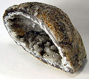 Geode
Geode
s are found in southeast Iowa and are the official state rock. They consist of grey to pink cobbles within limestone
that when cut or smashed open reveal a hollow crystal-filled interior. Geodes are common around Geode State Park
in Henry County
.
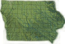 Despite popular perception, Iowa is generally not flat; most of the state consists of rolling hills. Prior divides Iowa into eight landform
s based on glaciation, soil
s, topography
, and river
drainage:
s, deep V-shaped valleys, caves, springs, and sinkhole
s. Glacial deposits and loess
are thin or absent over most of the region.
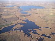 Often called the Prairie Pothole Region, the Des Moines Lobe was glaciated up until 12,000 years ago during the Wisconsin glaciation
. The area is marked by rolling terrain and ridges. Historically, this area was peppered with small interconnected swamps, most of which were drained for farmland. The Iowa Great Lakes
occur along the western edge of the Des Moines lobe.
in Iowa runs through the SIDP. The classic Iowa landscape, consisting of rolling hills of Wisconsin-age loess on Illinoian (or earlier) till
. The SIDP is some of the most productive agricultural land in the world.
s are found within the broad Mississippi River
valley.
consist of very thick deposits of loess in far western Iowa deposited during the Wisconsin and Illinoian periods. Highly eroded, leaving stark, beautiful "golden hills".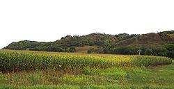
, muted relief except for steep rolling hills near river valleys, and deeper valleys. These picturesque hills are depicted in many of the landscapes of Grant Wood
.
is contained in a much narrower channel. In Iowa, the eastern border of the Missouri Plains is the Loess Hills, forming steep rounded bluffs.
 As in most of the U.S., surface water in Iowa is never safe to drink untreated, contamination by agricultural runoff including nitrates, herbicides, pesticides, and animal waste is common. Municipal water supplies are typically heavily chlorinated, this chlorine, combined with high nitrate levels, often give municipal water a strong smell, and the limestone bedrock in much of the state causes hard water. Some communities, such as Iowa City resort to additional carbon filtration and lime softening
coagulation-sedimentation to make the water more palatable. Water treatment can be surprisingly effective; Des Moines' advanced filtration system has led to water quality ranked among the nation's best.
production, and the diminishment of resupply caused by extensive field tiling. The aquifer has dropped by as much as 300 feet since the 19th century, resulting in dry wells, the disappearance of natural surface springs, and the diminishment of water quality.
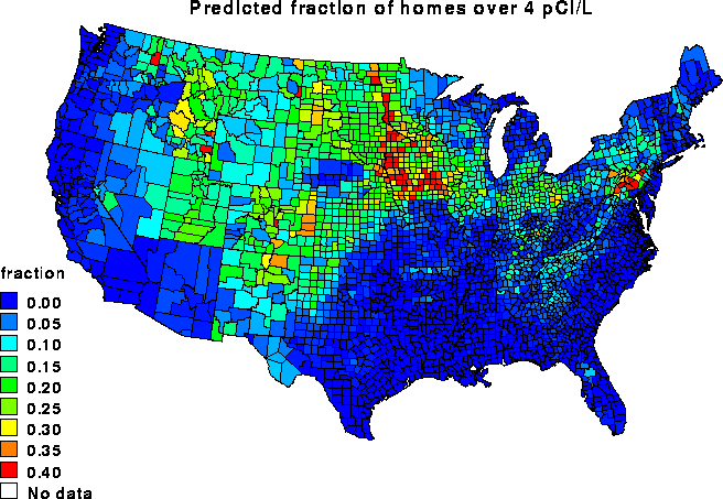 Like most Upper Midwest and Plains states, radon
is a common problem in Iowa, especially in areas with clay-rich soils.
Dam in Johnson County
, exposing a rich collection of Devonian
-age fossil
s. This area has been transformed into a visitors' center, where hikers can tour the bedrock. Unfortunately, looters have illegally removed many of the better fossils. The June 2008 floods expanded the fossil bed floor, and removed some of the weathered overburden.
and Cretaceous
bedrock in western Iowa have potential to contain dinosaur remains, and in nearby parts of Nebraska Hadrosaurid
(“duck-billed”) ornithopod
dinosaur remains have been recovered in Cretaceous bedrock similar to that of Iowa. The deep loess that covers much of western Iowa typically conceals the bedrock, limiting opportunities to finding dinosaurs to mining and quarrying operations.
and paleontological
sites in Iowa have produced an extensive collection of Pleistocene
and Holocene
animals; these have been used to reconstruct past environmental conditions in the Midwest. Some of the earliest paleoclimatic reconstructions of the midcontinent were made from Iowa collections, such as the Cherokee Sewer Site
.
giant sloth
is under excavation along West Tarkio Creek near Shenandoah, Iowa
. Three individuals of Megalonyx
Jeffersoni, or Jefferson's Ground Sloth, have been identified so far, including one adult and two juveniles of different ages.
Geology
Geology is the science comprising the study of solid Earth, the rocks of which it is composed, and the processes by which it evolves. Geology gives insight into the history of the Earth, as it provides the primary evidence for plate tectonics, the evolutionary history of life, and past climates...
. For the study of buried human cultural remains in Iowa, see Iowa archaeology
Iowa archaeology
The archaeology of Iowa is the study of the buried remains of human culture within the state of Iowa from the earliest prehistoric through the late historic periods. When the American Indians first arrived in what is now Iowa more than 13,000 years ago, they were hunters and gatherers living in a...
.
The geology of Iowa includes the study of bedrock, landforms, geography, and paleontology of the state of Iowa
Iowa
Iowa is a state located in the Midwestern United States, an area often referred to as the "American Heartland". It derives its name from the Ioway people, one of the many American Indian tribes that occupied the state at the time of European exploration. Iowa was a part of the French colony of New...
.
Notable Iowa geologists
Samuel CalvinSamuel Calvin (geologist)
Samuel Calvin was Iowa's first systematic geologist, helping to make the first bedrock and landform maps of Iowa, as well as leading geological research throughout the state. He was born in Scotland, attended Lenox College in Hopkinton, Iowa, where he later taught. One of his collaborators was...
(1840–1911) was Iowa's first systematic geologist, who helped to make the first bedrock and landform maps of Iowa, as well as lead geological research throughout the state. Calvin Hall at the University of Iowa
University of Iowa
The University of Iowa is a public state-supported research university located in Iowa City, Iowa, United States. It is the oldest public university in the state. The university is organized into eleven colleges granting undergraduate, graduate, and professional degrees...
is named for him. Clair Cameron Patterson
Clair Cameron Patterson
Clair Cameron Patterson was a geochemist born in Mitchellville, Iowa, United States. He graduated from Grinnell College in Grinnell, Iowa, received his Ph.D...
(1922–1995) developed the lead-lead dating and calculated an age for the Earth of 4.55 billion years; a figure far more accurate than those that existed at the time and one that has remained unchanged for over 50 years. Charles Rollin Keyes
Charles Rollin Keyes
For the Iowa archaeologist, see Charles Reuben Keyes.Charles Rollin Keyes was a U.S. geologist and in 1918 was a U.S. Senate candidate in Iowa. Born in Des Moines, Iowa, he graduated from Iowa State University in 1887. He worked for the United States Geological Survey. He earned a Ph.D. from Johns...
was also an early Iowa geologist who helped map the soils and bedrock of southeast Iowa; he, with Calvin, was a founder of the Iowa Geological Survey.
Bedrock features
Iowa's bedrock geology generally increases in age from west to east. In northwest Iowa CretaceousCretaceous
The Cretaceous , derived from the Latin "creta" , usually abbreviated K for its German translation Kreide , is a geologic period and system from circa to million years ago. In the geologic timescale, the Cretaceous follows the Jurassic period and is followed by the Paleogene period of the...
bedrock is ca. 74 million years old, in eastern Iowa Cambrian
Cambrian
The Cambrian is the first geological period of the Paleozoic Era, lasting from Mya ; it is succeeded by the Ordovician. Its subdivisions, and indeed its base, are somewhat in flux. The period was established by Adam Sedgwick, who named it after Cambria, the Latin name for Wales, where Britain's...
bedrock dates to ca. 500 million years ago.
Manson impact structure
Seventy-four million years ago, a large asteroid crashed into what is now southeast Pocahontas countyPocahontas County, Iowa
-2010 census:The 2010 census recorded a population of 7,310 in the county, with a population density of . There were 3,794 housing units, of which 3,233 were occupied.-2000 census:...
creating the Manson crater
Manson crater
The Manson impact crater is near the site of Manson, Iowa where an asteroid or comet nucleus struck the Earth during the Cretaceous Period, 74 Ma...
. Probably a mile in diameter, it would have killed most animals within 650 miles, roughly an area from modern Denver to Detroit. This was originally thought to have been one of the causes of the dinosaur
Dinosaur
Dinosaurs are a diverse group of animals of the clade and superorder Dinosauria. They were the dominant terrestrial vertebrates for over 160 million years, from the late Triassic period until the end of the Cretaceous , when the Cretaceous–Paleogene extinction event led to the extinction of...
extinction, but recalculation of the impact's age indicates it occurred some 12 million years before the mass extinction. Although glaciation has erased all surface evidence of the impact, the bedrock associated with this impact is unique in Iowa.
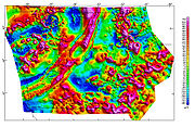
Midcontinent rift
Midcontinent Rift System
The Midcontinent Rift System or Keweenawan Rift is a long geological rift in the center of the North American continent and south-central part of the North American plate. It formed when the continent's core, the North American craton, began to split apart during the Mesoproterozoic era of the...
can be seen clearly in magnetic anomaly maps of Iowa. This is a billion-year-old tectonic plate scar that extends from Kansas through Lake Superior
Lake Superior
Lake Superior is the largest of the five traditionally-demarcated Great Lakes of North America. It is bounded to the north by the Canadian province of Ontario and the U.S. state of Minnesota, and to the south by the U.S. states of Wisconsin and Michigan. It is the largest freshwater lake in the...
. This rift is not seismically active.
Seismic activity
No major active fault lines exist in Iowa, and Iowa is one of the most seismically stable states in the U.S. With the exception of an 1968 Illinois earthquake which caused the water tower at Lineville, IowaLineville, Iowa
Lineville is a city in Wayne County, Iowa, United States. The population was 273 at the 2000 census.-Geography:Lineville is located at .According to the United States Census Bureau, the city has a total area of , all of it land....
to leak, no injuries or significant damage has ever been caused by earthquake
Earthquake
An earthquake is the result of a sudden release of energy in the Earth's crust that creates seismic waves. The seismicity, seismism or seismic activity of an area refers to the frequency, type and size of earthquakes experienced over a period of time...
s in Iowa. Occasional small earthquakes occur near Fremont County
Fremont County, Iowa
-2010 census:The 2010 census recorded a population of 7,441 in the county, with a population density of . There were 3,431 housing units, of which 3,064 were occupied.-2000 census:...
in the far southwest and the Sioux City area can occasionally be shaken by nearby tremblors. Large earthquakes associated with the New Madrid Fault of far southern Illinois and Missouri can occasionally be felt in eastern Iowa.
Fossil fuels
Coal
Coal is a combustible black or brownish-black sedimentary rock usually occurring in rock strata in layers or veins called coal beds or coal seams. The harder forms, such as anthracite coal, can be regarded as metamorphic rock because of later exposure to elevated temperature and pressure...
producer, particularly the Des Moines River
Des Moines River
The Des Moines River is a tributary river of the Mississippi River, approximately long to its farther headwaters, in the upper Midwestern United States...
valley from Coalville
Coalville, Iowa
Coalville is a census-designated place in Webster County, Iowa, United States. The population was 591 at the 2000 census. The community is located on U.S. Route 20 near Fort Dodge's large gypsum mines.-History:...
south. Much of the greater City of Des Moines area was mined. Boone
Boone, Iowa
Boone is a city in and the county seat of Des Moines Township, Boone County, Iowa, United States. It is the principal city of the 'Boone, Iowa Micropolitan Statistical Area', which encompasses all of Boone County. This micropolitan statistical area, along with the 'Ames, Iowa Metropolitan...
and What Cheer
What Cheer, Iowa
What Cheer is a city in Keokuk County, Iowa, United States. The population was 678 at the 2000 census.- The name What Cheer :When the future What Cheer was founded in 1865, it was named Petersburg for Peter Britton, the settlement's founder. This name was rejected by the Post Office, forcing a...
were important in the late 19th century. In the 20th century, the most important mines were farther south around Albia
Albia, Iowa
Albia is a city in and the county seat of Monroe County, Iowa, United States. The population was 3,706 at the 2000 census.-Geography:Albia's longitude and latitude coordinatesin decimal form are 41.026600, −92.805262....
, Centerville
Centerville, Iowa
Centerville is a city in and the county seat of Appanoose County, Iowa, United States. The population was 5,528 in the 2010 census, a decline from 5,924 in the 2000 census. After the turn of the 20th century Centerville had a booming coal mining industry that attracted many European immigrants...
, Lucas
Lucas, Iowa
Lucas is a city in Lucas County, Iowa, United States. The population was 243 at the 2000 census.-History:The Burlington and Missouri River Railroad Company established a station at Lucas in 1866, named after Lucas County and Robert Lucas. A plat for the town was filed on May 9, 1868 and the town...
and Oskaloosa
Oskaloosa, Iowa
Oskaloosa is the county seat of Mahaska County, Iowa, United States. The population was 11,463 in the 2010 census, an increase from 10,938 in the 2000 census. -History:...
. Iowa coal tends to be too high in sulfur
Sulfur
Sulfur or sulphur is the chemical element with atomic number 16. In the periodic table it is represented by the symbol S. It is an abundant, multivalent non-metal. Under normal conditions, sulfur atoms form cyclic octatomic molecules with chemical formula S8. Elemental sulfur is a bright yellow...
for modern applications, and the last commercial mine closed in 1994.
Iowa has very limited natural gas
Natural gas
Natural gas is a naturally occurring gas mixture consisting primarily of methane, typically with 0–20% higher hydrocarbons . It is found associated with other hydrocarbon fuel, in coal beds, as methane clathrates, and is an important fuel source and a major feedstock for fertilizers.Most natural...
and oil
Petroleum
Petroleum or crude oil is a naturally occurring, flammable liquid consisting of a complex mixture of hydrocarbons of various molecular weights and other liquid organic compounds, that are found in geologic formations beneath the Earth's surface. Petroleum is recovered mostly through oil drilling...
production.
Sioux quartzite
Although Iowa's bedrock is generally younger in western parts of the state, one exception is a small part of far northwest Iowa where PrecambrianPrecambrian
The Precambrian is the name which describes the large span of time in Earth's history before the current Phanerozoic Eon, and is a Supereon divided into several eons of the geologic time scale...
Sioux quartzite
Sioux Quartzite
The Sioux Quartzite is a Proterozoic quartzite that is found in region around the intersection of Minnesota, South Dakota, and Iowa, and correlates with other rock units throughout the upper midwestern and southwestern United States...
bedrock is found in northwest Lyon County
Lyon County, Iowa
-2010 census:The 2010 census recorded a population of 11,581 in the county, with a population density of . There were 4,848 housing units, of which 4,442 were occupied.-2000 census:...
. Sioux quartzite
Quartzite
Quartzite is a hard metamorphic rock which was originally sandstone. Sandstone is converted into quartzite through heating and pressure usually related to tectonic compression within orogenic belts. Pure quartzite is usually white to gray, though quartzites often occur in various shades of pink...
is a very hard rock of ruddy pink color used extensively in the region for road and railroad beds.
Geodes
Geode
Geodes are geological secondary sedimentary structures which occur in sedimentary and certain volcanic rocks. Geodes are essentially spherical masses of mineral matter that were deposited sygenetically within the rock formations they are found in. Geodes have a Chalcedony shell containing...
s are found in southeast Iowa and are the official state rock. They consist of grey to pink cobbles within limestone
Limestone
Limestone is a sedimentary rock composed largely of the minerals calcite and aragonite, which are different crystal forms of calcium carbonate . Many limestones are composed from skeletal fragments of marine organisms such as coral or foraminifera....
that when cut or smashed open reveal a hollow crystal-filled interior. Geodes are common around Geode State Park
Geode State Park
Geode State Park is a state park of Iowa, USA, border Henry County and Des Moines County It is managed by the Iowa Department of Natural Resources. While it is named for Iowa's state rock, the geode , few can be found in the park. A display of geodes, with their mysterious crystal formations in...
in Henry County
Henry County, Iowa
-2010 census:The 2010 census recorded a population of 20,145 in the county, with a population density of . There were 8,280 housing units, of which 7,666 were occupied.-2000 census:...
.
Landforms and topography
Landform
A landform or physical feature in the earth sciences and geology sub-fields, comprises a geomorphological unit, and is largely defined by its surface form and location in the landscape, as part of the terrain, and as such, is typically an element of topography...
s based on glaciation, soil
Soil
Soil is a natural body consisting of layers of mineral constituents of variable thicknesses, which differ from the parent materials in their morphological, physical, chemical, and mineralogical characteristics...
s, topography
Topography
Topography is the study of Earth's surface shape and features or those ofplanets, moons, and asteroids...
, and river
River
A river is a natural watercourse, usually freshwater, flowing towards an ocean, a lake, a sea, or another river. In a few cases, a river simply flows into the ground or dries up completely before reaching another body of water. Small rivers may also be called by several other names, including...
drainage:
Paleozoic plateau
Also known as the Driftless Area, this region of scenic, high relief landscapes includes such features as resistant, bluff-forming bedrock outcropOutcrop
An outcrop is a visible exposure of bedrock or ancient superficial deposits on the surface of the Earth. -Features:Outcrops do not cover the majority of the Earth's land surface because in most places the bedrock or superficial deposits are covered by a mantle of soil and vegetation and cannot be...
s, deep V-shaped valleys, caves, springs, and sinkhole
Sinkhole
A sinkhole, also known as a sink, shake hole, swallow hole, swallet, doline or cenote, is a natural depression or hole in the Earth's surface caused by karst processes — the chemical dissolution of carbonate rocks or suffosion processes for example in sandstone...
s. Glacial deposits and loess
Loess
Loess is an aeolian sediment formed by the accumulation of wind-blown silt, typically in the 20–50 micrometre size range, twenty percent or less clay and the balance equal parts sand and silt that are loosely cemented by calcium carbonate...
are thin or absent over most of the region.
Des Moines lobe
Wisconsin glaciation
The last glacial period was the most recent glacial period within the current ice age occurring during the last years of the Pleistocene, from approximately 110,000 to 10,000 years ago....
. The area is marked by rolling terrain and ridges. Historically, this area was peppered with small interconnected swamps, most of which were drained for farmland. The Iowa Great Lakes
Iowa Great Lakes
The Iowa Great Lakes are a group of natural glacial lakes in Dickinson County in northwestern Iowa in the United States. The three principal lakes of the group are Spirit Lake, West Okoboji Lake, and East Okoboji Lake. They are the largest natural lakes in the state of Iowa. The largest, Spirit...
occur along the western edge of the Des Moines lobe.
Southern Iowa drift plain
The southern Iowa drift plain covers most of the southern half of Iowa. This is probably the most familiar landscape to travelers, since most of Interstate 80Interstate 80
Interstate 80 is the second-longest Interstate Highway in the United States, following Interstate 90. It is a transcontinental artery running from downtown San Francisco, California to Teaneck, New Jersey in the New York City Metropolitan Area...
in Iowa runs through the SIDP. The classic Iowa landscape, consisting of rolling hills of Wisconsin-age loess on Illinoian (or earlier) till
Till
thumb|right|Closeup of glacial till. Note that the larger grains in the till are completely surrounded by the matrix of finer material , and this characteristic, known as matrix support, is diagnostic of till....
. The SIDP is some of the most productive agricultural land in the world.
Mississippi alluvial plain
Generally level areas of stream terraces, paleochannels, backwater sloughs, and oxbow lakeOxbow lake
An oxbow lake is a U-shaped body of water formed when a wide meander from the main stem of a river is cut off to create a lake. This landform is called an oxbow lake for the distinctive curved shape, named after part of a yoke for oxen. In Australia, an oxbow lake is called a billabong, derived...
s are found within the broad Mississippi River
Mississippi River
The Mississippi River is the largest river system in North America. Flowing entirely in the United States, this river rises in western Minnesota and meanders slowly southwards for to the Mississippi River Delta at the Gulf of Mexico. With its many tributaries, the Mississippi's watershed drains...
valley.
Loess hills
The Loess HillsLoess Hills
The Loess Hills are a formation of wind-deposited loess soil in the westernmost part of Iowa and Missouri along the Missouri River.-Geology:The Loess Hills are generally located between 1 and east of the Missouri River channel...
consist of very thick deposits of loess in far western Iowa deposited during the Wisconsin and Illinoian periods. Highly eroded, leaving stark, beautiful "golden hills".
Iowan surface
Northeast Iowa is covered with eroded Illinoian till with moderate loess formation, frequently in the form of paha ridgesPaha (landform)
A Paha is a hill or ridge, typically formed of sand and capped with loess. The word paha means hill in Dakota Sioux. The most well known Paha is the paha around which the town of Mount Vernon, Iowa developed.- Origin :...
, muted relief except for steep rolling hills near river valleys, and deeper valleys. These picturesque hills are depicted in many of the landscapes of Grant Wood
Grant Wood
Grant DeVolson Wood was an American painter, born four miles east of Anamosa, Iowa. He is best known for his paintings depicting the rural American Midwest, particularly the painting American Gothic, an iconic image of the 20th century.- Life and career :His family moved to Cedar Rapids after his...
.
Northwest Iowa plains
Like the Iowan Surface, the Northwest Iowa Plains are rolling hills consisting of eroded soils developed since pre-Wisconsinan glaciation, but with significant amounts of loess.Missouri alluvial plain
Perhaps the only truly flat region of Iowa, the Missouri Alluvial Plain contains areas of terraces, sloughs, and oxbows. Its valley trench is not as deep as the Mississippi River system, and the Missouri RiverMissouri River
The Missouri River flows through the central United States, and is a tributary of the Mississippi River. It is the longest river in North America and drains the third largest area, though only the thirteenth largest by discharge. The Missouri's watershed encompasses most of the American Great...
is contained in a much narrower channel. In Iowa, the eastern border of the Missouri Plains is the Loess Hills, forming steep rounded bluffs.
Water
Lime softening
Lime softening, also known as Clark's process, is a type of water treatment used for water softening. In the USA, it is used primarily in the Midwest, Florida and Texas. It utilizes the addition of lime to remove hardness ions by precipitation...
coagulation-sedimentation to make the water more palatable. Water treatment can be surprisingly effective; Des Moines' advanced filtration system has led to water quality ranked among the nation's best.
Jordan Aquifer
The Jordan Aquifer is the largest source of groundwater, extending from northeast Iowa to south central Iowa, and is ultimately the source of much of Iowa's agricultural and industrial water. In addition to pollution threats, the aquifer is threatened by overuse in well-source irrigation, ethanolEthanol
Ethanol, also called ethyl alcohol, pure alcohol, grain alcohol, or drinking alcohol, is a volatile, flammable, colorless liquid. It is a psychoactive drug and one of the oldest recreational drugs. Best known as the type of alcohol found in alcoholic beverages, it is also used in thermometers, as a...
production, and the diminishment of resupply caused by extensive field tiling. The aquifer has dropped by as much as 300 feet since the 19th century, resulting in dry wells, the disappearance of natural surface springs, and the diminishment of water quality.
Soils
The NRCS divides Iowa into 23 soil regions. In general, soils of southern, eastern, and western Iowa are loess-derived, while soils of northern and central Iowa are till-derived. Most level areas of Iowa have soils highly suitable for agriculture, making Iowa one of the most productive farming regions of the world.Radon
Radon
Radon is a chemical element with symbol Rn and atomic number 86. It is a radioactive, colorless, odorless, tasteless noble gas, occurring naturally as the decay product of uranium or thorium. Its most stable isotope, 222Rn, has a half-life of 3.8 days...
is a common problem in Iowa, especially in areas with clay-rich soils.
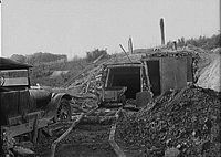
Devonian Fossil Gorge
Floods in 1993 washed away all the soil and unconsolidated bedrock along the spillway of the Coralville LakeCoralville Lake
Coralville Lake is a reservoir formed by Coralville Dam, a dam on the Iowa River just upstream from the city of Coralville, Iowa. Construction started in 1949, was delayed by the Korean War, and finally finished in 1958...
Dam in Johnson County
Johnson County, Iowa
-2010 census:The 2010 census recorded a population of 130,882 in the county, with a population density of . There were 55,967 housing units, of which 52,715 were occupied.-2000 census:...
, exposing a rich collection of Devonian
Devonian
The Devonian is a geologic period and system of the Paleozoic Era spanning from the end of the Silurian Period, about 416.0 ± 2.8 Mya , to the beginning of the Carboniferous Period, about 359.2 ± 2.5 Mya...
-age fossil
Fossil
Fossils are the preserved remains or traces of animals , plants, and other organisms from the remote past...
s. This area has been transformed into a visitors' center, where hikers can tour the bedrock. Unfortunately, looters have illegally removed many of the better fossils. The June 2008 floods expanded the fossil bed floor, and removed some of the weathered overburden.
Dinosaurs
JurassicJurassic
The Jurassic is a geologic period and system that extends from about Mya to Mya, that is, from the end of the Triassic to the beginning of the Cretaceous. The Jurassic constitutes the middle period of the Mesozoic era, also known as the age of reptiles. The start of the period is marked by...
and Cretaceous
Cretaceous
The Cretaceous , derived from the Latin "creta" , usually abbreviated K for its German translation Kreide , is a geologic period and system from circa to million years ago. In the geologic timescale, the Cretaceous follows the Jurassic period and is followed by the Paleogene period of the...
bedrock in western Iowa have potential to contain dinosaur remains, and in nearby parts of Nebraska Hadrosaurid
Hadrosaurid
Hadrosaurids or duck-billed dinosaurs are members of the family Hadrosauridae, and include ornithopods such as Edmontosaurus and Parasaurolophus. They were common herbivores in the Upper Cretaceous Period of what are now Asia, Europe and North America. They are descendants of the Upper...
(“duck-billed”) ornithopod
Ornithopod
Ornithopods or members of the clade Ornithopoda are a group of ornithischian dinosaurs that started out as small, bipedal running grazers, and grew in size and numbers until they became one of the most successful groups of herbivores in the Cretaceous world, and dominated the North American...
dinosaur remains have been recovered in Cretaceous bedrock similar to that of Iowa. The deep loess that covers much of western Iowa typically conceals the bedrock, limiting opportunities to finding dinosaurs to mining and quarrying operations.
Paleofauna
ArchaeologicalArchaeology
Archaeology, or archeology , is the study of human society, primarily through the recovery and analysis of the material culture and environmental data that they have left behind, which includes artifacts, architecture, biofacts and cultural landscapes...
and paleontological
Paleontology
Paleontology "old, ancient", ὄν, ὀντ- "being, creature", and λόγος "speech, thought") is the study of prehistoric life. It includes the study of fossils to determine organisms' evolution and interactions with each other and their environments...
sites in Iowa have produced an extensive collection of Pleistocene
Pleistocene
The Pleistocene is the epoch from 2,588,000 to 11,700 years BP that spans the world's recent period of repeated glaciations. The name pleistocene is derived from the Greek and ....
and Holocene
Holocene
The Holocene is a geological epoch which began at the end of the Pleistocene and continues to the present. The Holocene is part of the Quaternary period. Its name comes from the Greek words and , meaning "entirely recent"...
animals; these have been used to reconstruct past environmental conditions in the Midwest. Some of the earliest paleoclimatic reconstructions of the midcontinent were made from Iowa collections, such as the Cherokee Sewer Site
Cherokee Sewer Site
The Cherokee Sewer Site is a multi-component Prehistoric Indian Archaic bison processing site excavated in 1973 and 1976 near the sewage treatment plant of Cherokee, Iowa; it is not associated with the Cherokee tribe. It is important because it shows a transition in bison hunting strategy during...
.
Tarkio giant sloth
A PleistocenePleistocene
The Pleistocene is the epoch from 2,588,000 to 11,700 years BP that spans the world's recent period of repeated glaciations. The name pleistocene is derived from the Greek and ....
giant sloth
Sloth
Sloths are the six species of medium-sized mammals belonging to the families Megalonychidae and Bradypodidae , part of the order Pilosa and therefore related to armadillos and anteaters, which sport a similar set of specialized claws.They are arboreal residents of the jungles of Central and South...
is under excavation along West Tarkio Creek near Shenandoah, Iowa
Shenandoah, Iowa
Shenandoah is a city in Fremont and Page Counties in the U.S. state of Iowa. The population was 5,546 at the 2000 census.Once referred to as the "seed and nursery center of the world," Shenandoah is the home to Earl May Seed Company and the radio station KMA, founded by Earl May...
. Three individuals of Megalonyx
Megalonyx
Megalonyx is an extinct genus of giant ground sloths of the family Megalonychidae endemic to North America from the Hemphillian of the Late Miocene through to the Rancholabrean of the Pleistocene, living from ~10.3 Mya—11,000 years ago, existing for approximately .-Taxonomy:The generic name...
Jeffersoni, or Jefferson's Ground Sloth, have been identified so far, including one adult and two juveniles of different ages.
External links
- Iowa Geological Survey, http://www.igsb.uiowa.edu/
- Iowa Geographical Map Server, http://cairo.gis.iastate.edu/
- U.S. Geological Survey Iowa Overview, http://www.usgs.gov/state/state.asp?State=IA
- Web Soil Survey, http://websoilsurvey.nrcs.usda.gov/app/WebSoilSurvey.aspx
- NRCS Soil Survey, http://soils.usda.gov/technical/classification/osd/index.html
- Geological Society of Iowa, http://www.iowageology.org/
- Loess Hills Geology, http://pubs.usgs.gov/info/loess/
- University of Iowa Geoscience, http://www.uiowa.edu/~geology/
- Iowa Geological Society Annual Report, http://ir.uiowa.edu/igsar/
- Iowa Geological Survey Publication on coal, http://ir.uiowa.edu/igs_pubs/
- Samuel Calvin geological photographs, http://digital.lib.uiowa.edu/cdm4/index_calvin.php?CISOROOT=/calvin