

Geology of Pennsylvania
Encyclopedia
Pennsylvania
The Commonwealth of Pennsylvania is a U.S. state that is located in the Northeastern and Mid-Atlantic regions of the United States. The state borders Delaware and Maryland to the south, West Virginia to the southwest, Ohio to the west, New York and Ontario, Canada, to the north, and New Jersey to...
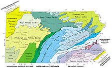
consists of six distinct physiographic provinces, three of which are subdivided into different sections. Each province has its own economic advantages and geologic hazards
Geologic hazards
A geologic hazard is one of several types of adverse geologic conditions capable of causing damage or loss of property and life. These hazards consist of sudden phenomena and slow phenomena:Sudden phenomena include:...
and play an important role in shaping everyday life in the state. They are: (listed from the southeast corner to the northwest corner) the Atlantic Coastal Plain
Atlantic Coastal Plain
The Atlantic coastal plain has both low elevation and low relief, but it is also a relatively flat landform extending from the New York Bight southward to a Georgia/Florida section of the Eastern Continental Divide, which demarcates the plain from the ACF River Basin in the Gulf Coastal Plain to...
Province, the Piedmont
Piedmont (United States)
The Piedmont is a plateau region located in the eastern United States between the Atlantic Coastal Plain and the main Appalachian Mountains, stretching from New Jersey in the north to central Alabama in the south. The Piedmont province is a physiographic province of the larger Appalachian division...
Province, the New England Province, the Ridge and Valley
Ridge-and-valley Appalachians
The Ridge-and-Valley Appalachians, also called the Ridge and Valley Province or the Valley and Ridge Appalachians, are a physiographic province of the larger Appalachian division and are also a belt within the Appalachian Mountains extending from southeastern New York through northwestern New...
Province, the Appalachian Plateau
Appalachian Plateau
The Appalachian Plateau is the western part of the Appalachian mountains, stretching from New York and Alabama. The plateau is a second level United States physiographic region....
Province, and the Central Lowlands Province.
A majority of the rocks in Pennsylvania exposed at the surface are sedimentary and were deposited during the Paleozoic Era. Almost all of the metamorphic and igneous rocks are confined to the southeast portion of the state. A total of four orogenies
Orogeny
Orogeny refers to forces and events leading to a severe structural deformation of the Earth's crust due to the engagement of tectonic plates. Response to such engagement results in the formation of long tracts of highly deformed rock called orogens or orogenic belts...
have affected the rocks of the Commonwealth including the Grenville orogeny
Grenville orogeny
The Grenville Orogeny was a long-lived Mesoproterozoic mountain-building event associated with the assembly of the supercontinent Rodinia. Its record is a prominent orogenic belt which spans a significant portion of the North American continent, from Labrador to Mexico, as well as to Scotland...
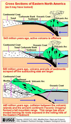
, the Taconic orogeny
Taconic orogeny
The Taconic orogeny was a mountain building period that ended 440 million years ago and affected most of modern-day New England. A great mountain chain formed from eastern Canada down through what is now the Piedmont of the East coast of the United States...
, the Acadian orogeny
Acadian orogeny
The Taconic, Acadian and Alleghenian orogenies are the three tectonic phases responsible for the formation of the present Appalachian Mountains. The Acadian orogeny is a middle Paleozoic mountain building episode dating back 325-400 million years which should not be regarded as a single event but...
, and the Appalachian orogeny. The Appalachian event has left the most evidence and has continued to shape the landscape of the state. The Pennsylvania terrain has also been affected by continental rifting during the Mesozoic era.
Pleistocene glaciers have also repeatedly visited the state over the last 100,000 years. These glaciers have left some evidence and carved out much of the landscape of the northern tier of the state.
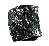
Anthracite coal
Anthracite is a hard, compact variety of mineral coal that has a high luster...
. Before mining began, there was an estimated 22.8 billion tons of anthracite in Pennsylvania. As of 2001, 12 billion tons still remain in the ground, most of which is not economically feasible to mine. American geologists recognized the importance of Pennsylvania's coal region and named the Upper Carboniferous
Carboniferous
The Carboniferous is a geologic period and system that extends from the end of the Devonian Period, about 359.2 ± 2.5 Mya , to the beginning of the Permian Period, about 299.0 ± 0.8 Mya . The name is derived from the Latin word for coal, carbo. Carboniferous means "coal-bearing"...
Period the Pennsylvanian
Pennsylvanian
The Pennsylvanian is, in the ICS geologic timescale, the younger of two subperiods of the Carboniferous Period. It lasted from roughly . As with most other geochronologic units, the rock beds that define the Pennsylvanian are well identified, but the exact date of the start and end are uncertain...
Period because of the abundance of coal in the state. Despite this, Celestine was proposed as the state mineral in 2002. The proposal however, was not approved by the state legislature.
Pennsylvania is also home to the famous Drake Oil Well
Drake Well Museum
The Drake Well Museum is a museum that interprets the birth of the American oil industry in 1859 by "Colonel" Edwin Drake along the banks of Oil Creek in Cherrytree Township, Venango County, Pennsylvania in the United States. The museum collects and preserves related artifacts...
in Titusville
Titusville, Pennsylvania
Titusville is a city in Crawford County, Pennsylvania, United States. The population was 6,146 at the 2000 census. In 1859, oil was successfully drilled in Titusville, resulting in the birth of the modern oil industry.-History:...
which help give rise to the modern oil industry and two brand name motor oils, Quaker State
Royal Dutch Shell
Royal Dutch Shell plc , commonly known as Shell, is a global oil and gas company headquartered in The Hague, Netherlands and with its registered office in London, United Kingdom. It is the fifth-largest company in the world according to a composite measure by Forbes magazine and one of the six...
(now owned by Royal Dutch Shell) and Pennzoil
Pennzoil
Pennzoil is an American oil company founded in Los Angeles, California in 1913. In 1955, it was acquired by Oil City, Pennsylvania company South Penn Oil, a former branch of Standard Oil. In 1963, South Penn Oil merged with Zapata Petroleum; the merged company took the Pennzoil name. During the...
. Pennsylvania also has reserves of natural gas from both deeply buried source rocks and coal-bed areas.
Atlantic Coastal Plain
One of the smallest provinces in the state and is confined to Philadelphia, DelawareDelaware County, Pennsylvania
Delaware County is a county located in the U.S. state of Pennsylvania. As of 2010, the population was 558,979, making it Pennsylvania's fifth most populous county, behind Philadelphia, Allegheny, Montgomery, and Bucks counties....
, and Bucks
Bucks County, Pennsylvania
- Industry and commerce :The boroughs of Bristol and Morrisville were prominent industrial centers along the Northeast Corridor during World War II. Suburban development accelerated in Lower Bucks in the 1950s with the opening of Levittown, Pennsylvania, the second such "Levittown" designed by...
counties along the Delaware River
Delaware River
The Delaware River is a major river on the Atlantic coast of the United States.A Dutch expedition led by Henry Hudson in 1609 first mapped the river. The river was christened the South River in the New Netherland colony that followed, in contrast to the North River, as the Hudson River was then...
. Local relief is less than 200 feet (61 m) and much of the bedrock
Bedrock
In stratigraphy, bedrock is the native consolidated rock underlying the surface of a terrestrial planet, usually the Earth. Above the bedrock is usually an area of broken and weathered unconsolidated rock in the basal subsoil...
is buried under recent alluvial deposits. On the geologic map, "Trenton Gravel" is used to describe most of these sediments. However, much of the alluvial sediments that exist here are sand, silt, and clays. The traditional boundary of the coastal plain is the fall line
Fall line
A fall line is a geomorphologic unconformity between an upland region of relatively hard crystalline basement rock and a coastal plain of softer sedimentary rock. A fall line is typically prominent when crossed by a river, for there will often be rapids or waterfalls...
. The coastal plain in Pennsylvania was once home to thousands of acres of fresh water tidal marsh
Marsh
In geography, a marsh, or morass, is a type of wetland that is subject to frequent or continuous flood. Typically the water is shallow and features grasses, rushes, reeds, typhas, sedges, other herbaceous plants, and moss....
. This was important in the early development of Philadelphia and Chester
Chester, Pennsylvania
Chester is a city in Delaware County, Pennsylvania, United States, with a population of 33,972 at the 2010 census. Chester is situated on the Delaware River, between the cities of Philadelphia and Wilmington, Delaware.- History :...
. Many of the small tributaries to the Delaware have cut small but impressive gorges into the bedrock including the Ridley Creek
Ridley Creek
Ridley Creek is a tributary of the Delaware River in southeast Pennsylvania in the United States. The entire drainage basin is in the suburban Philadelphia area, but the upper creek and extensive park lands on the creek retain a rural character, while the mouth of the creek has long been heavily...
, the Chester Creek
Chester Creek
thumb|upright=1.45|Chester Creek near [[Upland, Pennsylvania]]Chester Creek is a tributary of the Delaware River in Delaware County, Pennsylvania in the United States.-East Branch:...
, and the Wissahickon Creek
Wissahickon Creek
Wissahickon Creek is a stream in southeastern Pennsylvania. Rising in Montgomery County, Pennsylvania, it runs about 23 miles passing through and dividing Northwest Philadelphia before emptying into the Schuylkill River at Philadelphia...
. Flash floods are becoming a local problem in the province.
Piedmont
The piedmont in Pennsylvania is divided into three distinct sections: the Piedmont Uplands, the Piedmont Lowlands, and the Gettysburg-Newark Lowlands. Much of the Piedmont is becoming urbanized and developed. Some of the best farmland in the state is in this region, specifically LancasterLancaster County, Pennsylvania
Lancaster County, known as the Garden Spot of America or Pennsylvania Dutch Country, is a county located in the southeastern part of the Commonwealth of Pennsylvania, in the United States. As of 2010 the population was 519,445. Lancaster County forms the Lancaster Metropolitan Statistical Area, the...
and Chester
Chester County, Pennsylvania
-State parks:*French Creek State Park*Marsh Creek State Park*White Clay Creek Preserve-Demographics:As of the 2010 census, the county was 85.5% White, 6.1% Black or African American, 0.2% Native American or Alaskan Native, 3.9% Asian, 0.0% Native Hawaiian, 1.8% were two or more races, and 2.4% were...
counties.
Piedmont Uplands
Rodinia
In geology, Rodinia is the name of a supercontinent, a continent which contained most or all of Earth's landmass. According to plate tectonic reconstructions, Rodinia existed between 1.1 billion and 750 million years ago, in the Neoproterozoic era...
during the Grenville orogeny. These rocks eventually provided the platform for the deposition of sediment that would become the Wissahickon Formation
Wissahickon Formation
The Wissahickon Formation is a mapped bedrock unit in Pennsylvania, New Jersey, and Delaware. In Maryland, the term "Wissahickon" is no longer used and has since been divided into several units. It is named for the Wissahickon gorge in Fairmount Park, Philadelphia.-Description:The Wissahickon is...
during a rifting of Rodinia. Sea floor spreading continued until a passive margin
Passive margin
A passive margin is the transition between oceanic and continental crust which is not an active plate margin. It is constructed by sedimentation above an ancient rift, now marked by transitional crust. Continental rifting creates new ocean basins. Eventually the continental rift forms a mid-oceanic...
developed along the new Iapetus Ocean
Iapetus Ocean
The Iapetus Ocean was an ocean that existed in the Neoproterozoic and Paleozoic eras of the geologic timescale . The Iapetus Ocean was situated in the southern hemisphere, between the paleocontinents of Laurentia, Baltica and Avalonia...
and a beach strandline developed. These sediments eventually became the Chickies Formation
Chickies Formation
The Cambrian Chickies Formation is a mapped bedrock unit in Pennsylvania and Maryland. It is named for Chickies Rock, north of Columbia, Pennsylvania along the Susquehanna River.-Description:...
.
Siliclasitc and carbonate deposition continued through the Cambrian and into the Ordovician period. During the Taconic orogeny, more igneous intrusions and metamorphism occurred as the ancestral Taconic Mountains were pushed up. The sediments that were deposited in a sea between an island-arc and the Iapetus eventually were squeezed and deformed along a subduction
Subduction
In geology, subduction is the process that takes place at convergent boundaries by which one tectonic plate moves under another tectonic plate, sinking into the Earth's mantle, as the plates converge. These 3D regions of mantle downwellings are known as "Subduction Zones"...
zone. The sediments deposited in that sea are now located in the Great Valley section. (See below) The sediments placed from the rifting of Rodinia became the roots of the ancestral Taconics and went through their first wave of metamorphism during the Taconic orogeny. Additional waves of metamorphism continued up until the Alleghanian orogeny.
Piedmont Lowlands
The lowlands are underlain primarily by more easily erodedErosion
Erosion is when materials are removed from the surface and changed into something else. It only works by hydraulic actions and transport of solids in the natural environment, and leads to the deposition of these materials elsewhere...
rocks such as limestone
Limestone
Limestone is a sedimentary rock composed largely of the minerals calcite and aragonite, which are different crystal forms of calcium carbonate . Many limestones are composed from skeletal fragments of marine organisms such as coral or foraminifera....
, dolostone
Dolostone
Dolostone or dolomite rock is a sedimentary carbonate rock that contains a high percentage of the mineral dolomite. In old U.S.G.S. publications it was referred to as magnesian limestone. Most dolostone formed as a magnesium replacement of limestone or lime mud prior to lithification. It is...
, and phyllite
Phyllite
Phyllite is a type of foliated metamorphic rock primarily composed of quartz, sericite mica, and chlorite; the rock represents a gradation in the degree of metamorphism between slate and mica schist. Minute crystals of graphite, sericite, or chlorite impart a silky, sometimes golden sheen to the...
. These rocks are relatively younger in age then the surrounding uplands and are likely the result of a quiet stretch of shallow sea deposition. Some of the rocks deposited during this time are also found in the Great Valley section but have been separated by the Gettysburg-Newark Lowland section. Relief is low and generally never rises above 700 feet (213.4 m). Karst
KARST
Kilometer-square Area Radio Synthesis Telescope is a Chinese telescope project to which FAST is a forerunner. KARST is a set of large spherical reflectors on karst landforms, which are bowlshaped limestone sinkholes named after the Kras region in Slovenia and Northern Italy. It will consist of...
terrain is problematic in this section.
Gettysburg-Newark Lowlands
This section is a bit misleading since there are hills as high as 1200 feet (366 m) in this section. It is separated from the rest of the Piedmont sections due to the distinctive rock types found here. Also called the Triassic BasinNewark Group
The Newark Group, also known as the Newark Supergroup, is an assemblage of Late Triassic and Early Jurassic sedimentary rocks which outcrop intermittently along the United States East Coast; the exposures extend from Massachusetts to North Carolina, with more still in Nova Scotia...
, most of the bedrock are red sandstone
Sandstone
Sandstone is a sedimentary rock composed mainly of sand-sized minerals or rock grains.Most sandstone is composed of quartz and/or feldspar because these are the most common minerals in the Earth's crust. Like sand, sandstone may be any colour, but the most common colours are tan, brown, yellow,...
, siltstone
Siltstone
Siltstone is a sedimentary rock which has a grain size in the silt range, finer than sandstone and coarser than claystones.- Description :As its name implies, it is primarily composed of silt sized particles, defined as grains 1/16 - 1/256 mm or 4 to 8 on the Krumbein phi scale...
, and shale
Shale
Shale is a fine-grained, clastic sedimentary rock composed of mud that is a mix of flakes of clay minerals and tiny fragments of other minerals, especially quartz and calcite. The ratio of clay to other minerals is variable. Shale is characterized by breaks along thin laminae or parallel layering...
. A few formations are brown and black. The sediment accumulated during the rifting of Pangea in the Triassic
Triassic
The Triassic is a geologic period and system that extends from about 250 to 200 Mya . As the first period of the Mesozoic Era, the Triassic follows the Permian and is followed by the Jurassic. Both the start and end of the Triassic are marked by major extinction events...
age. Also, a basaltic igneous rock
Igneous rock
Igneous rock is one of the three main rock types, the others being sedimentary and metamorphic rock. Igneous rock is formed through the cooling and solidification of magma or lava...
called diabase
Diabase
Diabase or dolerite is a mafic, holocrystalline, subvolcanic rock equivalent to volcanic basalt or plutonic gabbro. In North American usage, the term diabase refers to the fresh rock, whilst elsewhere the term dolerite is used for the fresh rock and diabase refers to altered material...
formed dykes and sills
Sill (geology)
In geology, a sill is a tabular sheet intrusion that has intruded between older layers of sedimentary rock, beds of volcanic lava or tuff, or even along the direction of foliation in metamorphic rock. The term sill is synonymous with concordant intrusive sheet...
later in the Jurassic
Jurassic
The Jurassic is a geologic period and system that extends from about Mya to Mya, that is, from the end of the Triassic to the beginning of the Cretaceous. The Jurassic constitutes the middle period of the Mesozoic era, also known as the age of reptiles. The start of the period is marked by...
as the Atlantic Ocean began to form. Much of the rocks from this area have been eroded away, but the more erosion resistant diabase has left hills and small elevated regions throughout the section. The erosion patterns of these rocks played a pivotal role in the Battle of Gettysburg
Battle of Gettysburg
The Battle of Gettysburg , was fought July 1–3, 1863, in and around the town of Gettysburg, Pennsylvania. The battle with the largest number of casualties in the American Civil War, it is often described as the war's turning point. Union Maj. Gen. George Gordon Meade's Army of the Potomac...
.
Buckingham Valley
A small slice of PaleozoicPaleozoic
The Paleozoic era is the earliest of three geologic eras of the Phanerozoic eon, spanning from roughly...
rocks, mostly carbonates, exists in Buckingham Township
Buckingham Township, Bucks County, Pennsylvania
Buckingham Township is a township in Bucks County, Pennsylvania, United States. The population was 20,075 at the 2010 census. Buckingham takes its name from Buckingham in Buckinghamshire known as Bucks County in England...
. These rock lie north of the Furlong fault which is an offshoot of the larger Chalfont fault. Buckingham Mountain
Buckingham Mountain
Buckingham Mountain is located in Buckingham Township in Central Bucks County, Pennsylvania, in the United States. It is the second most elevated land in all of Bucks County at 520 feet.- History :...
rises south of the valley and comprises quartzite. The other ridge is less prominent and is underlain by the conglomerates of the Stockton Formation
Stockton Formation
The Triassic Stockton Formation is a mapped bedrock unit in Pennsylvania, New Jersey, and New York. It is named after Stockton, New Jersey, where it was first described...
. Karst is a localized problem in this area.
New England
Only a small and fragmented province in Pennsylvania called the Reading ProngReading Prong
The Reading Prong is a physiographic subprovince of the New England Uplands section of the New England province of the Appalachian Highlands. The prong consists of mountains made up of crystalline metamorphic rock.-Location:...
. This is the southern end of the Hudson Highlands
Hudson Highlands
The Hudson Highlands are mountains on both sides of the Hudson River in the U.S. state of New York, between Newburgh Bay and Haverstraw Bay, which form the northern region of the New York - New Jersey Highlands....
of New York and New Jersey
New Jersey
New Jersey is a state in the Northeastern and Middle Atlantic regions of the United States. , its population was 8,791,894. It is bordered on the north and east by the state of New York, on the southeast and south by the Atlantic Ocean, on the west by Pennsylvania and on the southwest by Delaware...
(known as the Ramapo Mountains
Ramapo Mountains
The Ramapo Mountains are a forested chain of the Appalachian mountains in northeastern New Jersey and southeastern New York in the United States...
in New Jersey) and the Taconic Mountains
Taconic Mountains
The Taconic Mountains or Taconic Range are a physiographic section of the larger New England province and part of the Appalachian Mountains, running along the eastern border of New York State and adjacent New England from northwest Connecticut to western Massachusetts, north to central western...
of New York. The granitic rocks and quartzite of this area are highly metamorphosed and are Pre-Cambrian to Cambrian
Cambrian
The Cambrian is the first geological period of the Paleozoic Era, lasting from Mya ; it is succeeded by the Ordovician. Its subdivisions, and indeed its base, are somewhat in flux. The period was established by Adam Sedgwick, who named it after Cambria, the Latin name for Wales, where Britain's...
in age. Hills and ridges are locally steep and rounded at the top and form the hills around Reading
Reading, Pennsylvania
Reading is a city in southeastern Pennsylvania, USA, and seat of Berks County. Reading is the principal city of the Greater Reading Area and had a population of 88,082 as of the 2010 census, making it the fifth most populated city in the state after Philadelphia, Pittsburgh, Allentown and Erie,...
, and to the south of the Allentown-Bethlehem-Easton metropolitan area. (See also South Mountain
South Mountain (eastern Pennsylvania)
South Mountain is a colloquial name applied to features in the mountain range extending south and south west from the Lehigh Valley to the Lebanon Valley regions of Pennsylvania. At times, it also been known as Durham Hills, Reading Hills, and the Lehigh Mountains...
)
Ridge and Valley
NASA
The National Aeronautics and Space Administration is the agency of the United States government that is responsible for the nation's civilian space program and for aeronautics and aerospace research...
's LANDSAT images. This province is the second largest in the state and is home to the famous anthracite fields. The rocks here are severely folded and contain numerous anticline
Anticline
In structural geology, an anticline is a fold that is convex up and has its oldest beds at its core. The term is not to be confused with antiform, which is a purely descriptive term for any fold that is convex up. Therefore if age relationships In structural geology, an anticline is a fold that is...
s and syncline
Syncline
In structural geology, a syncline is a fold, with younger layers closer to the center of the structure. A synclinorium is a large syncline with superimposed smaller folds. Synclines are typically a downward fold, termed a synformal syncline In structural geology, a syncline is a fold, with younger...
s that plunge and fold back over each other. There are numerous thrust faults that help create a chaotic mess. Most of the deformation is result of continent to continent collision
Plate tectonics
Plate tectonics is a scientific theory that describes the large scale motions of Earth's lithosphere...
during the Alleghenian orogeny
Alleghenian orogeny
The Alleghenian orogeny or Appalachian orogeny is one of the geological mountain-forming events that formed the Appalachian Mountains and Allegheny Mountains. The term and spelling Alleghany orogeny was originally proposed by H.P. Woodward in 1957....
. There are seven distinct regions of the province and they are listed below. Much of the drainage patterns in the province is trellis
Drainage system (Geomorphology)
In geomorphology, a drainage system is the pattern formed by the streams, rivers, and lakes in a particular drainage basin. They are governed by the topography of the land, whether a particular region is dominated by hard or soft rocks, and the gradient of the land. Geomorphologists and...
.
South Mountain
South MountainSouth Mountain (Maryland and Pennsylvania)
South Mountain is the northern extension of the Blue Ridge Mountain range in Maryland and Pennsylvania. From the Potomac River near Knoxville, Maryland in the south, to Dillsburg, Pennsylvania in the north, the long range separates the Hagerstown and Cumberland valleys from the Piedmont regions of...
is the northern tip of the Blue Ridge Mountains
Blue Ridge Mountains
The Blue Ridge Mountains are a physiographic province of the larger Appalachian Mountains range. This province consists of northern and southern physiographic regions, which divide near the Roanoke River gap. The mountain range is located in the eastern United States, starting at its southern-most...
. This region is characterized by broad flat ridges with deep narrow valleys. The rocks here are highly metamorphosed igneous and sedimentary rocks with some occasional dolomite. These rocks are Pre-Cambrian in age.
Great Valley
The Great Appalachian ValleyGreat Appalachian Valley
The Great Valley, also called the Great Appalachian Valley or Great Valley Region, is one of the major landform features of eastern North America. It is a gigantic trough — a chain of valley lowlands — and the central feature of the Appalachian Mountain system...
is a long broad valley that extends from Canada to Alabama
Alabama
Alabama is a state located in the southeastern region of the United States. It is bordered by Tennessee to the north, Georgia to the east, Florida and the Gulf of Mexico to the south, and Mississippi to the west. Alabama ranks 30th in total land area and ranks second in the size of its inland...
. In Pennsylvania, the valley is known by three names: (listed from north to south)
the Lehigh Valley
Lehigh Valley
The Lehigh Valley, known officially by the United States Census Bureau as the Allentown-Bethlehem-Easton, PA-NJ metropolitan area and referred to locally as The Valley and A-B-E, is a metropolitan region consisting of Lehigh, Northampton, Berks, and Carbon counties in eastern Pennsylvania and...
, the Lebanon Valley
Lebanon Valley
The Lebanon Valley is a geographic region that lies between South Mountain and the Ridge and Valley Province of eastern Pennsylvania, United States. The valley lies almost entirely within Lebanon and Berks counties in Pennsylvania. Portions of the valley lie in eastern Dauphin and northern...
, and the Cumberland Valley
Cumberland Valley
The Cumberland Valley is a constituent valley of the Great Appalachian Valley and a North American agricultural region within the Atlantic Seaboard watershed in Pennsylvania and Maryland....
. Rocks that characterize this region include: limestone, dolostone, slate
Slate
Slate is a fine-grained, foliated, homogeneous metamorphic rock derived from an original shale-type sedimentary rock composed of clay or volcanic ash through low-grade regional metamorphism. The result is a foliated rock in which the foliation may not correspond to the original sedimentary layering...
, shale, sandstone, siltstone, and some scattered basalt. Almost all of the rocks in the Great Valley in Pennsylvania are Ordovician
Ordovician
The Ordovician is a geologic period and system, the second of six of the Paleozoic Era, and covers the time between 488.3±1.7 to 443.7±1.5 million years ago . It follows the Cambrian Period and is followed by the Silurian Period...
in age and were deposited during a quiet period before the Taconic orogeny
Taconic orogeny
The Taconic orogeny was a mountain building period that ended 440 million years ago and affected most of modern-day New England. A great mountain chain formed from eastern Canada down through what is now the Piedmont of the East coast of the United States...
. The limestones and dolostones of this area are extensively quarried in Pennsylvania. These carbonate rocks are used for variety of purposes including, crushed stone, cement
Portland cement
Portland cement is the most common type of cement in general use around the world because it is a basic ingredient of concrete, mortar, stucco and most non-specialty grout...
manufacturing, fertilizers, and coal-mine dust (reduces acid mine drainage
Acid mine drainage
Acid mine drainage , or acid rock drainage , refers to the outflow of acidic water from metal mines or coal mines. However, other areas where the earth has been disturbed may also contribute acid rock drainage to the environment...
) Karst features are problematic in the Great Valley.
Blue Mountain
Escarpment
An escarpment is a steep slope or long cliff that occurs from erosion or faulting and separates two relatively level areas of differing elevations.-Description and variants:...
separating the Appalachian Mountains from the Great Valley. Many of Pennsylvania's water gap
Water gap
A water gap is an opening or notch which flowing water has carved through a mountain range. Water gaps often offer a practical route for road and rail transport to cross mountain ridges.- Geology :...
s cut through Blue Mountain including Delaware Water Gap
Delaware Water Gap
The Delaware Water Gap is on the border of New Jersey and Pennsylvania where the Delaware River cuts through a large ridge of the Appalachian Mountains...
, Lehigh Gap
Lehigh Gap, Pennsylvania
The Lehigh Gap, located in Lower Towamensing Township, Carbon County, Pennsylvania, is a water gap formed by the Lehigh River where it cuts through Blue Mountain in the state of Pennsylvania in the United States. The gap allows easy travel between Carbon County to the north and Lehigh and...
, Schuylkill Gap
Schuylkill Gap
Schuylkill Gap is a water gap through Blue Mountain located about 3 miles north of Hamburg, Pennsylvania. The borough of Port Clinton, Pennsylvania resides within the gap itself....
, and Susquehanna Gap. Also along the ridge, many "wind gaps" also exist. (see separate article) The rocks of the Blue Mountain section include mostly Silurian
Silurian
The Silurian is a geologic period and system that extends from the end of the Ordovician Period, about 443.7 ± 1.5 Mya , to the beginning of the Devonian Period, about 416.0 ± 2.8 Mya . As with other geologic periods, the rock beds that define the period's start and end are well identified, but the...
aged sandstone, conglomerate
Conglomerate (geology)
A conglomerate is a rock consisting of individual clasts within a finer-grained matrix that have become cemented together. Conglomerates are sedimentary rocks consisting of rounded fragments and are thus differentiated from breccias, which consist of angular clasts...
, siltstone, shale, and some limestone. Blue mountain is also known by the names: Kittatinny Mountain (especially in New Jersey) and Hawk Mountain
Hawk Mountain
Hawk Mountain is a mountain ridge, part of the Blue Mountain Ridge in the Appalachian Mountain chain, located in central-eastern Pennsylvania near Reading and Allentown. The area includes 13,000 acres of protected private and public land, including the 2,600 acre Hawk Mountain Sanctuary.The River...
. One of the most prominent rock types of this section is the Shawangunk Formation
Shawangunk Formation
The Silurian Shawangunk Formation is a mapped bedrock unit in eastern Pennsylvania, New Jersey, and New York. It is named for the Shawangunk Ridge for which it is the dominant rock type. The division of the Shawangunk between the Tuscarora Formation and Clinton Group has not been conclusively...
which is named after the Shawangunk Ridge
Shawangunk Ridge
The Shawangunk Ridge , also known as the Shawangunk Mountains or The Gunks, is a ridge of bedrock in Ulster County, Sullivan County and Orange County in the state of New York, extending from the northernmost point of New Jersey to the Catskill Mountains.The ridgetop, which widens considerably at...
of New York.
The sediments that comprise Blue Mountain were deposited as a result of the highlands that formed after the Taconic orogeny. The first wave of sediments were coarse, gray, and poorly sorted. (The Shawngunk Formation) This combination of depositional features means that the source area was relatively close and deposited in a moist climate. These sediments grade into finer reddish sands and silts, (Bloomsburg Formation) as the source area became more distant and/or less productive. The climate during this time was drier.
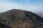
Anthracite upland
Arguably the most complex and most studied section in the state, this area is home to one of Pennsylvania's most profitable coal fields ever, containing high-grade Anthracite coal. The sediments deposited during the Mississippian Period came from highlands located to the southeast. Waves of mountain building occasionally brought coarser-grained sediments onto the plain. As the mountains eroded, the sediments became more fine-grained. As the highlands became more distant (or more eroded) the sands would grade into silt or clay.Since the North American Plate
North American Plate
The North American Plate is a tectonic plate covering most of North America, Greenland, Cuba, Bahamas, and parts of Siberia, Japan and Iceland. It extends eastward to the Mid-Atlantic Ridge and westward to the Chersky Range in eastern Siberia. The plate includes both continental and oceanic crust...
was near the equator, a tropical climate existed and allowed dense forests to flourish. Beginning in the Late Mississippian, forests of Lycopodiophyta
Lycopodiophyta
The Division Lycopodiophyta is a tracheophyte subdivision of the Kingdom Plantae. It is the oldest extant vascular plant division at around 410 million years old, and includes some of the most "primitive" extant species...
, Arthrophyta, Pteridophyta, and Pteridospermatophyta
Pteridospermatophyta
The term Pteridospermatophyta refers to several distinct groups of extinct seed-bearing plants . The oldest fossil evidence of plants of this type is of late Devonian age, and they flourished particularly during the Carboniferous and Permian periods...
began to grow in these plains. As the conditions became more favorable for the dense forests to survive for hundred of thousands of years, much of the dead plant material became preserved in oxygen
Oxygen
Oxygen is the element with atomic number 8 and represented by the symbol O. Its name derives from the Greek roots ὀξύς and -γενής , because at the time of naming, it was mistakenly thought that all acids required oxygen in their composition...
-depleted environments. The accumulation of this material became preserved in the vast coal deposits. The rise and fall of the mountains, along with changes in sea level, occurred numerous times (often in conjunction). These cyclical stratagraphic events sequences are preserved in the rock record and are often called cyclothems
Cyclothems
In geology, cyclothems are alternating stratigraphic sequences of marine and non-marine sediments, sometimes interbedded with coal seams. Historically, the term was defined by the European coal geologists that worked in coal basins formed during the Carboniferous and earliest Permian periods...
. By the Late Permian, much of the continental plate collision had subsided; the mountain building however, still continued. All of the sediments deposited during the previous 30 million years became folded and faulted as the supercontinent Pangea was finally formed.
It would take 150 million years for the mountains of this area to finally achieve the shapes seen today. These mountains are steep-sided and valleys are canoe-shaped, largely due to its complex folded structure. Most of the coal being mined from this section is from the Pennsylvanian-aged formations. Along with the Mazon Creek fossil
Fossil
Fossils are the preserved remains or traces of animals , plants, and other organisms from the remote past...
field in Illinois
Illinois
Illinois is the fifth-most populous state of the United States of America, and is often noted for being a microcosm of the entire country. With Chicago in the northeast, small industrial cities and great agricultural productivity in central and northern Illinois, and natural resources like coal,...
, a tremendous amount of plant fossils has been studied from this area. Landslides and acid mine drainage are two principal hazards of the area. In the past, underground mine fires have also been a threat. The Centralia Mine Fire
Centralia, Pennsylvania
Centralia is a borough and ghost town in Columbia County, Pennsylvania, United States. Its population has dwindled from over 1,000 residents in 1981 to 12 in 2005, 9 in 2007, and 10 in 2010, as a result of a mine fire burning beneath the borough since 1962...
is located within this section.
Anthracite Valley
Detached from the rest of Pennsylvania's anthracite fields, this canoe-shaped valley is also known as the Wyoming ValleyWyoming Valley
Wyoming Valley is a region of northeastern Pennsylvania. As a metropolitan area, it is also known as the Scranton/Wilkes-Barre area, after its principal cities, Scranton and Wilkes-Barre....
and is home to the cities of Scranton and Wilkes-Barre. The whole structure of the section is a double plunging syncline
Syncline
In structural geology, a syncline is a fold, with younger layers closer to the center of the structure. A synclinorium is a large syncline with superimposed smaller folds. Synclines are typically a downward fold, termed a synformal syncline In structural geology, a syncline is a fold, with younger...
with sharp mountain ridges on either side of the valley. The ridges meet just north of Carbondale
Carbondale, Pennsylvania
Carbondale is a city in Lackawanna County, Pennsylvania, United States. Carbondale is located approximately 15 miles due northeast of the city of Scranton in Northeastern Pennsylvania...
. The North Branch of the Susquehanna River
Susquehanna River
The Susquehanna River is a river located in the northeastern United States. At long, it is the longest river on the American east coast that drains into the Atlantic Ocean, and with its watershed it is the 16th largest river in the United States, and the longest river in the continental United...
along with the Lackawanna River
Lackawanna River
The Lackawanna River is a tributary of the Susquehanna River in northeastern Pennsylvania in the United States. It flows through a region of the northern Pocono Mountains that was once a center of anthracite coal mining in the United States...
flow through this valley. Large-scale coal mining along with its accompanying industry, railroads, have long been abandoned.
Unlike the southern and middle anthracite fields, the anthracite valley has been recently glaciated repeatedly. This has left many talus
Scree
Scree, also called talus, is a term given to an accumulation of broken rock fragments at the base of crags, mountain cliffs, or valley shoulders. Landforms associated with these materials are sometimes called scree slopes or talus piles...
slopes at the base of Moosic Mountains
Moosic Mountains
Moosic Mountains is a range in Jefferson Township, Pennsylvania which extends above sea level. Its highest point is Pocono Plateau, ranking 27th highest in Pennsylvania....
, and the soils often contain large boulders making excavation difficult.
Susquehanna Lowland
This region has also seen its landscape altered by glaciation and the fluvialFluvial
Fluvial is used in geography and Earth science to refer to the processes associated with rivers and streams and the deposits and landforms created by them...
processes of the Susquehanna River. Most of the ridges in this region are parallel to the streams that drain the area. The Susquehanna also cuts through many of the mountain ridges leading some to believe that the Susquehanna is an ancient river system that existed even before the recent continental glaciation. (Some speculate as far back as the Jurassic
Jurassic
The Jurassic is a geologic period and system that extends from about Mya to Mya, that is, from the end of the Triassic to the beginning of the Cretaceous. The Jurassic constitutes the middle period of the Mesozoic era, also known as the age of reptiles. The start of the period is marked by...
Period) None of the mountains in this section rise above 1700 feet (518 m) and the river valley is as low as 250 feet (76 m).
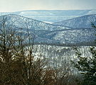
Appalachian Mountain
The standard long, narrow, and steep sided ridges with narrow valleys that define the state in LANDSAT photos. Many of the valleys have karst features due to carbonate rocks that reside in them. Road building generally follows the valleys and rarely cuts across the ridges. The Pennsylvania TurnpikePennsylvania Turnpike
The Pennsylvania Turnpike is a toll highway system operated by the Pennsylvania Turnpike Commission in the Commonwealth of Pennsylvania, United States. The three sections of the turnpike system total . The main section extends from Ohio to New Jersey and is long...
used tunnels cut into the ridges rather than scale the mountain tops. Mount Nittany
Mount Nittany
Mount Nittany is the common name for Nittany Mountain, a prominent geographic feature in Centre County, Pennsylvania. The mountain is actually part of a complex of ridges that separates Nittany Valley from Penns Valley, with the enclosed Sugar Valley between them...
, Tuscarora Mountain
Tuscarora Mountain
Tuscoarora Mountain is a mountain ridge of the Appalachian Mountains in the Ridge and Valley province in central Pennsylvania. It reaches its highest point on Big Mountain at 2,458 feet above sea level....
, Jacks Mountain
Jacks Mountain
Jacks Mountain is a stratigraphic ridge in central Pennsylvania, United States, trending southeast of the Stone Mountain ridge and Jacks Mountain Anticline. The ridge line separates Kishacoquillas Valley from the Ferguson and Dry Valleys...
, Wills Mountain
Wills Mountain
Wills Mountain is a quartzite-capped ridge in the Ridge and Valley physiographic province of the Appalachian Mountains in Pennsylvania and Maryland, USA, extending from near Bedford, Pennsylvania to near Cumberland, Maryland...
and Sideling Hill
Sideling Hill
Sideling Hill is a long, steep, narrow mountain ridge in the Ridge-and-Valley physiographic province of the Appalachian Mountains, located in Washington County in western Maryland and adjacent West Virginia and Pennsylvania, USA...
are five prominent mountains in this section.
The section contains Cambrian through Pennsylvanian-aged sediments all deposited into the Appalachian Basin. During the Appalachian orogany, these sediments became folded, faulted, and moved around. Only during the past few million years has the landscape we see today take shape. The relatively softer or easily weathered rocks became valleys while the harder and erosion-resistant rocks became the mountain ridges. The development of this landscape continues to this day.
Appalachian Plateau
By far the largest province in the state, most of the rocks in this region are not folded and faulted and sit relatively flat. In western Pennsylvania, large bituminous coalBituminous coal
Bituminous coal or black coal is a relatively soft coal containing a tarlike substance called bitumen. It is of higher quality than lignite coal but of poorer quality than Anthracite...
fields exist in rocks with a similar age as the rocks in the anthracite region. Many of the folds in the province are high amplitude and stretch for miles. In glaciated sections, steep canyons developed and much of the terrain have many glacial features
Glaciology
Glaciology Glaciology Glaciology (from Middle French dialect (Franco-Provençal): glace, "ice"; or Latin: glacies, "frost, ice"; and Greek: λόγος, logos, "speech" lit...
. The drainage pattern in this area is dendritic
Drainage system (Geomorphology)
In geomorphology, a drainage system is the pattern formed by the streams, rivers, and lakes in a particular drainage basin. They are governed by the topography of the land, whether a particular region is dominated by hard or soft rocks, and the gradient of the land. Geomorphologists and...
.
Glaciated Pocono Plateau
The Pocono MountainThe Poconos
The Pocono Mountains is a region located in northeastern Pennsylvania, United States. The Poconos, located chiefly in Monroe and Pike counties , are an upland of the larger Allegheny Plateau...
section of Pennsylvania is the same (geologically speaking) as the Catskill Mountains
Catskill Mountains
The Catskill Mountains, an area in New York State northwest of New York City and southwest of Albany, are a mature dissected plateau, an uplifted region that was subsequently eroded into sharp relief. They are an eastward continuation, and the highest representation, of the Allegheny Plateau...
of New York. The red-green-gray sedimentary rocks of the Catskill Formation are the predominant bedrock type in the Poconos. The elevation of the plateau is between 1200 feet (366 m) and 2300 feet (701 m) with only a few steep hills such as Camelback Mountain (Big Pocono)
Camelback Mountain (Big Pocono)
Camelback Mountain or Big Pocono is a conspicuous geographic feature on the Pocono Plateau. It is not a mountain, but rather a peninsular section of the Pocono Plateau, that when viewed from three sides, appears to be a mountain...
. Much of the rock sits in gently dipping horizontal beds, unlike the neighboring Appalachian Mountain section.
Glaciated Low Plateau
Considered a part of the Pocono Plateau, this area lies to the north of the poconos and contains many of the same types of rock. The local relief is less than that of the Pocono region and bounded to the southeast by the Delaware River. The Big Bushkill CreekBig Bushkill Creek
Big Bushkill Creek is a tributary of the Delaware River in the Poconos of eastern Pennsylvania in the United States....
cuts a gorge through this section and has many waterfalls especially around the area of Resica Falls Scout Reservation
Resica Falls Scout Reservation
Resica Falls Scout Reservation is a camp in East Stroudsburg, Pennsylvania operated by the Cradle of Liberty Council of the Boy Scouts of America. The reservation is part of a conservation easement with the Natural Lands Trust....
. Dingmans Falls
Dingmans Falls
Dingmans Falls is a waterfall located in Dingmans Ferry in Delaware Township, Pike County, Pennsylvania, United States near the Silverthread Falls. It has a vertical drop of 39.6 m .-See also:*Bushkill Falls*Silverthread Falls...
and Bushkill Falls
are waterfalls within the Delaware Water Gap National Recreation Area
Delaware Water Gap National Recreation Area
Delaware Water Gap National Recreation Area, administered by the National Park Service, preserves almost of land along the Delaware River's New Jersey and Pennsylvania shores, stretching from the Delaware Water Gap northward almost to the New York state line...
. Also a part of the Endless Mountains
Endless Mountains
The Endless Mountains are a chain of mountains in northeastern Pennsylvania. The Endless Mountains region includes Bradford, Sullivan, Susquehanna, Northern Wayne, and Wyoming Counties.-History and geography:...
region of Pennsylvania.
Glaciated High Plateau
Also an extension of the Catskill Mountains of New York, this section generally has higher elevations than the low plateau section as well as deeper valleys. Younger strata also outcrops in this area with a few minor coal beds. The uplands are rounded or flat along mostly broad hills. An excellent example of the escarpment that divides this section are Ricketts and Ganoga Glen located within Ricketts Glen State ParkRicketts Glen State Park
Ricketts Glen State Park is a Pennsylvania state park on in Columbia, Luzerne, and Sullivan counties in Pennsylvania in the United States. Ricketts Glen is a National Natural Landmark known for its old-growth forest and 24 named waterfalls along Kitchen Creek, which flows down the Allegheny...
.
Deep Valleys
This section is home to the Grand Canyon of PennsylvaniaPine Creek Gorge
Pine Creek Gorge, also known as, The Grand Canyon of Pennsylvania, is situated in approximately 160,000 acres of the Tioga State Forest in the U.S. State of Pennsylvania along Pine Creek. The Canyon begins south of Ansonia, near Wellsboro, along U.S. Route 6 and continues for approximately...
and some of the most remote areas of the state. As the name implies, the streams of this area have cut deep valleys with steep sided slopes of the surrounding ridges. Some of the gorges are at least 1000 feet (305 m) deep. Much of the area was forested at the end of the 19th century, and much of the area is owned by the Pennsylvania Bureau of Forestry.
Allegheny Front
Allegheny Front
The Allegheny Front is the major southeast- or east-facing escarpment in the Allegheny Mountains in southern Pennsylvania, western Maryland, and eastern West Virginia, USA. The Allegheny Front delineates the Ridge-and-Valley Appalachians to its east from the Appalachian Plateau to its west...
section includes the abrupt escarpment that divides the Ridge and Valley Province from the Allegheny Plateau. The region is a large broad ridge with a steep ascent from east to west and rolling hills away from the ridge. The Allegheny Front reaches its highest elevation in Pennsylvania at Blue Knob, 3136 feet (956 m), an unusual bulge along this symmetrical ridgeline. Streams that cut into the ridge are often shallow and steep.
Allegheny Mountain
This section includes Pennsylvania's highest point, Mount DavisMount Davis (Pennsylvania)
Mount Davis is the highest point in Pennsylvania. Located in the 5,685 acre Forbes State Forest in Elk Lick Township, Somerset County, it rises to 3,213 ft...
which stands at 3213 feet (979 m) above sea level. Many of the mountains are long and broad with relatively shallow and broad valleys. Unlike the Appalachian Mountain section, the streams of this area have not cut deep and well defined valleys into the earth. Much of the drainage pattern is dendritic with a little trellis where erosion resistant rocks have created higher and more well defined ridges. Elevations increase to the south, and Mt. Davis resides only 4.5 miles (7 km) from the Maryland
Maryland
Maryland is a U.S. state located in the Mid Atlantic region of the United States, bordering Virginia, West Virginia, and the District of Columbia to its south and west; Pennsylvania to its north; and Delaware to its east...
border. A few of the ridge tops contain some low-volatile bituminous coal fields including the Broad Top
Broad Top
Broad Top is a plateau located in south-central Pennsylvania. It extends into Huntingdon County to the north, Fulton County to the southeast, and Bedford County to the southwest. It is bounded to the west by Saxton Mountain and Terrace Mountain, and to the east by Sideling Hill. In Bedford...
field. This region is also home to two national stories: the Quecreek Mine Rescue
Quecreek Mine Rescue
The Quecreek Mine Rescue took place in Somerset County, Pennsylvania, when nine miners were trapped underground for over 78 hours, from July 24 to 28, 2002...
and the crash of United Airlines Flight 93
United Airlines Flight 93
United Airlines Flight 93 was United Airlines' scheduled morning transcontinental flight across the United States from Newark International Airport in Newark, New Jersey, to San Francisco International Airport in California. On Tuesday, September 11, 2001, the Boeing 757–222 aircraft operating the...
.
Waynesburg Hills
Located in the southwest corner of the state, the Waynesburg hills are another major coal producing area for the state. Much of the 64.4 billion tons of bituminous coal that is remaining in the state resides under these hills in near horizontal beds. The hills are narrow and steep sided with some deeper valleys.Pittsburgh Low Plateau
Another section that is a significant coal producer. It is similar to the Waynesburg hills section except for higher local relief and deeper valleys. Landslides and mine subsidenceSubsidence
Subsidence is the motion of a surface as it shifts downward relative to a datum such as sea-level. The opposite of subsidence is uplift, which results in an increase in elevation...
are common hazards.
High Plateau
This section consists of high, broad, and flat uplands cut by sharp and shallow river valleys. Much of this area was not covered by the Late Wisconsinan glacierWisconsin glaciation
The last glacial period was the most recent glacial period within the current ice age occurring during the last years of the Pleistocene, from approximately 110,000 to 10,000 years ago....
but there is evidence of pre-Wisconsinan glaciers in the area.
Northwestern Glaciated Plateau
This section has been influenced by glaciers and many of the valleys cut into the bedrock trend northwestward- in the direction of the retreating glaciers. There are many signs of glaciers including kameKame
A kame is a geological feature, an irregularly shaped hill or mound composed of sand, gravel and till that accumulates in a depression on a retreating glacier, and is then deposited on the land surface with further melting of the glacier...
s, esker
Esker
An esker is a long winding ridge of stratified sand and gravel, examples of which occur in glaciated and formerly glaciated regions of Europe and North America...
s, kettles, and moraines. This section is home to Pennsylvania's largest natural lake, Conneaut Lake
Conneaut Lake
Conneaut Lake is the largest natural lake in Pennsylvania. It is located in western Crawford County near a town with the same name. During the summer season, it is heavily populated with people vacationing to the lake area, some from the area spending time in their houses on the lake, and many...
as well as one of the longest eskers in the state, West Liberty Esker. Some of the drainage patterns have shifted and only a few of the streams flow into Lake Erie.
Central Lowlands
Along with the Coastal Plain Province, the smallest province in the state, the central lowlands are a part of the Great LakesGreat Lakes
The Great Lakes are a collection of freshwater lakes located in northeastern North America, on the Canada – United States border. Consisting of Lakes Superior, Michigan, Huron, Erie, and Ontario, they form the largest group of freshwater lakes on Earth by total surface, coming in second by volume...
area and exists along a glacial escapement adjacent to Lake Erie
Lake Erie
Lake Erie is the fourth largest lake of the five Great Lakes in North America, and the tenth largest globally. It is the southernmost, shallowest, and smallest by volume of the Great Lakes and therefore also has the shortest average water residence time. It is bounded on the north by the...
.
Geologic Features
The following is a list of notable Pennsylvania geologic features noted for their beauty and/or uniqueness.Periglacial
.jpg)
- Hickory Run State ParkHickory Run State ParkHickory Run State Park is a Pennsylvania state park in Kidder and Penn Forest Townships in Carbon County, Pennsylvania in the United States. The park is spread across the Pocono Mountains...
- Mount DavisMount Davis (Pennsylvania)Mount Davis is the highest point in Pennsylvania. Located in the 5,685 acre Forbes State Forest in Elk Lick Township, Somerset County, it rises to 3,213 ft...
Glacial
- Archbald Pothole
- Grand Canyon of PennsylvaniaPine Creek GorgePine Creek Gorge, also known as, The Grand Canyon of Pennsylvania, is situated in approximately 160,000 acres of the Tioga State Forest in the U.S. State of Pennsylvania along Pine Creek. The Canyon begins south of Ansonia, near Wellsboro, along U.S. Route 6 and continues for approximately...
- McConnells Mill State ParkMcConnells Mill State ParkMcConnells Mill State Park is a Pennsylvania state park in Perry and Slippery Rock Townships, Lawrence County, Pennsylvania in the United States. The park features a deep scenic gorge with the restored watermill and a covered bridge at the bottom, accessible by a roadway that winds between large,...
- Moraine State ParkMoraine State ParkMoraine State Park is a Pennsylvania state park on in Brady, Clay, Franklin, Muddy Creek, and Worth townships in Butler County, Pennsylvania, in the United States. The main feature of the park is its man-made lake, Lake Arthur, formed by impounding Muddy Creek, which is and is used for...
- Presque IslePresque Isle State ParkPresque Isle State Park is a Pennsylvania state park on an arching sandy peninsula that juts into Lake Erie, west of the city of Erie, in Millcreek Township, Erie County, Pennsylvania, in the United States. The peninsula sweeps northeastward, surrounding Presque Isle Bay along the park's...
- Promised Land State ParkPromised Land State ParkPromised Land State Park is a Pennsylvania state park in Blooming Grove, Greene and Palmyra Townships, Pike County, Pennsylvania, in the United States. The approximately park is mostly surrounded by Delaware State Forest. It is in the Poconos and sits at . The second growth forests in Promised...
- Ricketts Glen State ParkRicketts Glen State ParkRicketts Glen State Park is a Pennsylvania state park on in Columbia, Luzerne, and Sullivan counties in Pennsylvania in the United States. Ricketts Glen is a National Natural Landmark known for its old-growth forest and 24 named waterfalls along Kitchen Creek, which flows down the Allegheny...
- Worlds End State ParkWorlds End State ParkWorlds End State Park is a Pennsylvania state park in Sullivan County, Pennsylvania, in the United States. The park, nearly surrounded by Loyalsock State Forest, is in the Loyalsock Creek valley on Pennsylvania Route 154, in Forks and Shrewsbury Townships just east of the borough of Forksville....
Structural
- Bear Valley Strip MineBear Valley Strip MineThe Bear Valley Strip Mine is an abandoned coal strip mine located in Coal Township, Northumberland County, to the southwest of the town of Shamokin, Pennsylvania. It lies in the Western Middle Field of the Anthracite belt in the Ridge-and-Valley Appalachians, where the Pennsylvanian Llewellyn...
- Chickies Rock
- Delaware Water GapDelaware Water GapThe Delaware Water Gap is on the border of New Jersey and Pennsylvania where the Delaware River cuts through a large ridge of the Appalachian Mountains...
- Pole Steeple
- Governor StableGovernor StableGovernor Stable is a notable geologic formation in northern Lancaster County, Pennsylvania. Scattered along the northern bank of a small drainage are a high number of large diabase boulders. Governor Stable is privately owned. administers a recreational lease on the property, allowing...
- Ringing Rocks
- The Pinnacle