

Mendocino Fracture Zone
Encyclopedia
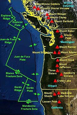
Fracture zone
A fracture zone is a linear oceanic feature--often hundreds, even thousands of kilometers long--resulting from the action of offset mid-ocean ridge axis segments. They are a consequence of plate tectonics. Lithospheric plates on either side of an active transform fault move in opposite directions;...
and transform boundary off the coast of Cape Mendocino
Cape Mendocino
Cape Mendocino located on the Lost Coast entirely within Humboldt County, California, USA, is the westernmost point on the coast of California. It has been a landmark since the 16th century when the Manila Galleons would reach the coast here following the prevailing westerlies all the way across...
in far northern California
California
California is a state located on the West Coast of the United States. It is by far the most populous U.S. state, and the third-largest by land area...
. It runs westward from a triple junction with the San Andreas Fault
San Andreas Fault
The San Andreas Fault is a continental strike-slip fault that runs a length of roughly through California in the United States. The fault's motion is right-lateral strike-slip...
and the Cascadia subduction zone
Cascadia subduction zone
The Cascadia subduction zone is a subduction zone, a type of convergent plate boundary that stretches from northern Vancouver Island to northern California. It is a very long sloping fault that separates the Juan de Fuca and North America plates.New ocean floor is being created offshore of...
to the southern end of the Gorda Ridge
Gorda Ridge
The Gorda Ridge is a tectonic spreading center located off the coast of Oregon and northern California north of Cape Mendocino. It runs from a triple junction with the San Andreas Fault and the Mendocino Fracture Zone northward to another transform boundary, the Blanco Fracture Zone...
. It continues on west of its junction with the Gorda Ridge, as an inactive remnant section which extends for several hundred miles.
Technically, a fracture zone is not a transform fault, but in the case of the Mendocino, the term has been loosely applied to the active fault segment east of the Gorda Ridge as well as to the true fracture zone segment west of it. Many seismologists refer to the active segment as the Mendocino Fault or Mendocino fault zone. The fault section demarcates the boundary between the northwestward-moving Pacific Plate
Pacific Plate
The Pacific Plate is an oceanic tectonic plate that lies beneath the Pacific Ocean. At 103 million square kilometres, it is the largest tectonic plate....
and the eastward-moving Gorda Plate
Gorda Plate
The Gorda Plate, located beneath the Pacific Ocean off the coast of northern California, is one of the northern remnants of the Farallon Plate. It is sometimes referred to as simply the southernmost portion of the neighboring Juan de Fuca Plate, another Farallon remnant.Unlike most tectonic...
. The Gorda Plate is subducting beneath the North American Plate just offshore of Cape Mendocino. Where the Mendocino Fault intersects the undersea trench of the subduction zone, it also meets the San Andreas Fault
San Andreas Fault
The San Andreas Fault is a continental strike-slip fault that runs a length of roughly through California in the United States. The fault's motion is right-lateral strike-slip...
. This seismically active intersection is called a triple junction
Triple junction
A triple junction is the point where the boundaries of three tectonic plates meet. At the triple junction a boundary will be one of 3 types - a ridge, trench or transform fault - and triple junctions can be described according to the types of plate margin that meet at them...
, and specifically the Mendocino Triple Junction
Mendocino Triple Junction
The Mendocino Triple Junction is a geologic triple junction where the San Andreas Fault meets the Mendocino Fault and the Cascadia subduction zone, separating three tectonic plates: the Pacific Plate, the North American Plate and the Gorda Plate...
.
History
Robert W. Pease observed in 1965 that the alignment of a transverse tectonic zone extending from Mount Lassen to the Walker LaneWalker Lane
The Walker Lane is a geologic trough roughly aligned with the California/Nevada border southward to where Death Valley intersects the Garlock Fault, a major left-lateral strike-slip fault...
at the north end of Honey Lake Fault, suggests it was once the continental terminus of the Mendocino Fault. It forms the boundary of the Modoc Plateau
Modoc Plateau
The Modoc Plateau lies in the northeast corner of California as well as parts of Oregon and Nevada. It is a mile-high expanse of lava flows with cinder cones, juniper flats, pine forests, and seasonal lakes. The plateau is thought to have been formed approximately 25 million years ago...
and Columbia Plateau
Columbia Plateau
The Columbia Plateau is a geologic and geographic region that lies across parts of the U.S. states of Washington, Oregon, and Idaho. It is a wide flood basalt plateau between the Cascade Range and the Rocky Mountains, cut through by the Columbia River...
provinces with the Great Basin
Great Basin
The Great Basin is the largest area of contiguous endorheic watersheds in North America and is noted for its arid conditions and Basin and Range topography that varies from the North American low point at Badwater Basin to the highest point of the contiguous United States, less than away at the...
. Where it meets Honey Lake Fault, it bends to trend northeast across the northwest corner of Nevada, where it accompanies the geological trough that forms Black Rock Desert
Black Rock Desert
The Black Rock Desert is an arid region in the northern Nevada section of the Great Basin with a lakebed that is a dry remnant of Pleistocene Lake Lahontan...
.