

Geology of New Jersey
Encyclopedia
New Jersey
New Jersey is a state in the Northeastern and Middle Atlantic regions of the United States. , its population was 8,791,894. It is bordered on the north and east by the state of New York, on the southeast and south by the Atlantic Ocean, on the west by Pennsylvania and on the southwest by Delaware...
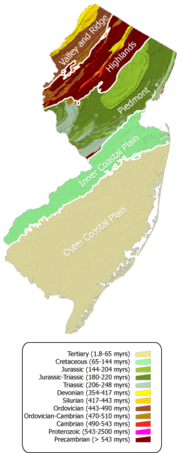
consists of four distinct physiographic provinces. They are: (listed from the south to the north) the Atlantic Coastal Plain
Atlantic Coastal Plain
The Atlantic coastal plain has both low elevation and low relief, but it is also a relatively flat landform extending from the New York Bight southward to a Georgia/Florida section of the Eastern Continental Divide, which demarcates the plain from the ACF River Basin in the Gulf Coastal Plain to...
Province, the Piedmont
Piedmont (United States)
The Piedmont is a plateau region located in the eastern United States between the Atlantic Coastal Plain and the main Appalachian Mountains, stretching from New Jersey in the north to central Alabama in the south. The Piedmont province is a physiographic province of the larger Appalachian division...
Province, the Highlands Province, and the Ridge and Valley
Ridge-and-valley Appalachians
The Ridge-and-Valley Appalachians, also called the Ridge and Valley Province or the Valley and Ridge Appalachians, are a physiographic province of the larger Appalachian division and are also a belt within the Appalachian Mountains extending from southeastern New York through northwestern New...
Province.
Coastal Plain
The largest province in the state, encompasses the southeast part of the state below the fall zone from TrentonTrenton, New Jersey
Trenton is the capital of the U.S. state of New Jersey and the county seat of Mercer County. As of the 2010 United States Census, Trenton had a population of 84,913...
to Woodbridge. It contains a large wedge of unconsolidated sediments that have been deposited since the Cretaceous
Cretaceous
The Cretaceous , derived from the Latin "creta" , usually abbreviated K for its German translation Kreide , is a geologic period and system from circa to million years ago. In the geologic timescale, the Cretaceous follows the Jurassic period and is followed by the Paleogene period of the...
Period. These sediments continue off-shore until the continental shelf
Continental shelf
The continental shelf is the extended perimeter of each continent and associated coastal plain. Much of the shelf was exposed during glacial periods, but is now submerged under relatively shallow seas and gulfs, and was similarly submerged during other interglacial periods. The continental margin,...
edge in the Atlantic Ocean
Atlantic Ocean
The Atlantic Ocean is the second-largest of the world's oceanic divisions. With a total area of about , it covers approximately 20% of the Earth's surface and about 26% of its water surface area...
. Topography is relatively flat with a few hills of erosion resistant sediments containing gravel or iron-sedimented sands. The province is divided further into three subprovinces: the Lowland section which are flat, often inundadted areas of tidal marshes, back bays, and barrier islands. This section generally follows the coastline, Delaware Bay
Delaware Bay
Delaware Bay is a major estuary outlet of the Delaware River on the Northeast seaboard of the United States whose fresh water mixes for many miles with the waters of the Atlantic Ocean. It is in area. The bay is bordered by the State of New Jersey and the State of Delaware...
, and Delaware River
Delaware River
The Delaware River is a major river on the Atlantic coast of the United States.A Dutch expedition led by Henry Hudson in 1609 first mapped the river. The river was christened the South River in the New Netherland colony that followed, in contrast to the North River, as the Hudson River was then...
. The intermediate upland section are raised areas inland and are best suited for farming and other agriculture. The sands of the coastal plain have been mined for foundry
Foundry
A foundry is a factory that produces metal castings. Metals are cast into shapes by melting them into a liquid, pouring the metal in a mold, and removing the mold material or casting after the metal has solidified as it cools. The most common metals processed are aluminum and cast iron...
sand and sand used for glass making. And finally, the upland section; which home to the New Jersey Pine Barrens and Fort Dix. Glauconite
Glauconite
Glauconite is an iron potassium phyllosilicate mineral of characteristic green color with very low weathering resistance and very friable.It crystallizes with a monoclinic geometry...
is commonly found in this section, especially around Freehold Township, New Jersey
Freehold Township, New Jersey
Freehold Township is a Township in Monmouth County, New Jersey, United States. As of the 2010 United States Census, the township population was 36,184. Freehold Township was first formed on October 31, 1693, and was incorporated as a township by an Act of the New Jersey Legislature on February 21,...
.
Piedmont
A majority of the rocks in this province are a part of the Newark SupergroupNewark Group
The Newark Group, also known as the Newark Supergroup, is an assemblage of Late Triassic and Early Jurassic sedimentary rocks which outcrop intermittently along the United States East Coast; the exposures extend from Massachusetts to North Carolina, with more still in Nova Scotia...
. They include the Passaic Formation
Passaic Formation
The Passaic Formation is a mapped bedrock unit in Pennsylvania, New Jersey, and New York. It was previously known as the Brunswick Formation since it was first described in the vicinity of New Brunswick, New Jersey. It is now named for the city of Passaic, New Jersey, which is near where its type...
, the Lockatong Formation
Lockatong Formation
The Triassic Lockatong Formation is a mapped bedrock unit in Pennsylvania, New Jersey, and New York. It is named after the Lockatong Creek in Hunterdon County, New Jersey.-Description:...
, the Stockton Formation
Stockton Formation
The Triassic Stockton Formation is a mapped bedrock unit in Pennsylvania, New Jersey, and New York. It is named after Stockton, New Jersey, where it was first described...
, and the igneous rocks basalt
Basalt
Basalt is a common extrusive volcanic rock. It is usually grey to black and fine-grained due to rapid cooling of lava at the surface of a planet. It may be porphyritic containing larger crystals in a fine matrix, or vesicular, or frothy scoria. Unweathered basalt is black or grey...
and diabase
Diabase
Diabase or dolerite is a mafic, holocrystalline, subvolcanic rock equivalent to volcanic basalt or plutonic gabbro. In North American usage, the term diabase refers to the fresh rock, whilst elsewhere the term dolerite is used for the fresh rock and diabase refers to altered material...
. In New Jersey, more basalt flows are evident with several named formations including the Hook Mountain Basalt, the Preakness Basalt, and the Orange Mountain Basalt. Diabase is prominently displayed along the Hudson River
Hudson River
The Hudson is a river that flows from north to south through eastern New York. The highest official source is at Lake Tear of the Clouds, on the slopes of Mount Marcy in the Adirondack Mountains. The river itself officially begins in Henderson Lake in Newcomb, New York...
in the Palisades Sill
Palisades Sill
The Palisades Sill is a Triassic, 200 Ma diabase intrusion. It extends through portions of New York and New Jersey. It is most noteworthy for The Palisades, the cliffs that rise steeply above the western bank of the Hudson River...
. These rocks were deposited during the rifting of Pangea during the Triassic
Triassic
The Triassic is a geologic period and system that extends from about 250 to 200 Mya . As the first period of the Mesozoic Era, the Triassic follows the Permian and is followed by the Jurassic. Both the start and end of the Triassic are marked by major extinction events...
and Jurassic
Jurassic
The Jurassic is a geologic period and system that extends from about Mya to Mya, that is, from the end of the Triassic to the beginning of the Cretaceous. The Jurassic constitutes the middle period of the Mesozoic era, also known as the age of reptiles. The start of the period is marked by...
Periods. Much of the northern segment of this region was glaciated and the resultant shaping help to form New York and Newark harbors.
A small portion of the Pennsylvania
Pennsylvania
The Commonwealth of Pennsylvania is a U.S. state that is located in the Northeastern and Mid-Atlantic regions of the United States. The state borders Delaware and Maryland to the south, West Virginia to the southwest, Ohio to the west, New York and Ontario, Canada, to the north, and New Jersey to...
Piedmont Highlands called the Trenton prong extends into New Jersey through Trenton and are mostly Ediacaran
Ediacaran
The Ediacaran Period , named after the Ediacara Hills of South Australia, is the last geological period of the Neoproterozoic Era and of the Proterozoic Eon, immediately preceding the Cambrian Period, the first period of the Paleozoic Era and of the Phanerozoic Eon...
and Cambrian
Cambrian
The Cambrian is the first geological period of the Paleozoic Era, lasting from Mya ; it is succeeded by the Ordovician. Its subdivisions, and indeed its base, are somewhat in flux. The period was established by Adam Sedgwick, who named it after Cambria, the Latin name for Wales, where Britain's...
aged rocks, that includes the Wissahickon Formation
Wissahickon Formation
The Wissahickon Formation is a mapped bedrock unit in Pennsylvania, New Jersey, and Delaware. In Maryland, the term "Wissahickon" is no longer used and has since been divided into several units. It is named for the Wissahickon gorge in Fairmount Park, Philadelphia.-Description:The Wissahickon is...
. The Manhattan schist
Manhattan schist
The Manhattan schist is a formation of mica schist rock that underlies much of the island of Manhattan in New York City. It is well suited for the foundations of tall buildings, and the two large concentrations of skyscrapers on the island occur in locations where the formation is close to the...
exists in New Jersey, largely below New York harbor and in the vicinity of Bayonne
Bayonne, New Jersey
Bayonne is a city in Hudson County, New Jersey, United States. Located in the Gateway Region, Bayonne is a peninsula that is situated between Newark Bay to the west, the Kill van Kull to the south, and New York Bay to the east...
and Jersey City.
Highlands
Around four hundred fifty million years, ago a volcanic island arcIsland arc
An island arc is a type of archipelago composed of a chain of volcanoes which alignment is arc-shaped, and which are situated parallel and close to a boundary between two converging tectonic plates....
formed and collided with proto North America. The islands rode over top of the North American plate creating the Highlands.
To the east of the Kittatinny Valley is the Highland province. A narrow fault of Hardyston Quartzite separates the Kittatinny Valley from the Highlands. Igneous and metamorphic rock from the Late Precambrian and Early Paleozoic era, make up the Highlands. Kittatinny and Franklin formation, along with Hardyston Quartzite are in the Highlands. The New Jersey Highlands geology is complicated due to complex patterns of folds, faults and intrusions.
The Highland Province has the Wawayanda Mountains which has an elevation of 1448 at two peaks; Sparta Mountain, elevation 1232: Pochuck Mountain, elevation 1194, north of Lake Pochung; Hamburg Mountain, elevation 1495 east of Lake Wildwood.
This section contains some the oldest rocks in New Jersey and is largely a mix of Pre-Cambrian granite
Granite
Granite is a common and widely occurring type of intrusive, felsic, igneous rock. Granite usually has a medium- to coarse-grained texture. Occasionally some individual crystals are larger than the groundmass, in which case the texture is known as porphyritic. A granitic rock with a porphyritic...
s and gniesses
Gneiss
Gneiss is a common and widely distributed type of rock formed by high-grade regional metamorphic processes from pre-existing formations that were originally either igneous or sedimentary rocks.-Etymology:...
and lower Paleozoic
Paleozoic
The Paleozoic era is the earliest of three geologic eras of the Phanerozoic eon, spanning from roughly...
clastic and carbonate
Limestone
Limestone is a sedimentary rock composed largely of the minerals calcite and aragonite, which are different crystal forms of calcium carbonate . Many limestones are composed from skeletal fragments of marine organisms such as coral or foraminifera....
rocks. The harder granites and gneisses produce steep sided hills and mountains since they are relatively resistant to erosion
Erosion
Erosion is when materials are removed from the surface and changed into something else. It only works by hydraulic actions and transport of solids in the natural environment, and leads to the deposition of these materials elsewhere...
. There are two small klippe
Klippe
thumb|right|350px|Schematic overview of a thrust system. The shaded material is called a [[nappe]]. The erosional hole is called a [[window |window or fenster]]. The klippe is the isolated block of the nappe overlying autochthonous material....
s in the southern part of this province, the Jutland klippe south of Musconetcong Mountain
Musconetcong Mountain
Musconetcong Mountain is a ridge in the Highlands region of New Jersey running south of and parallel to the Musconetcong River. The ridge travels through Alexandria, Holland, Bethlehem and Lebanon Township.-Central Delaware Valley American Viticultural Area:...
and the Peapack klippe in southern Morris County
Morris County, New Jersey
Morris County is a county located in the U.S. state of New Jersey, about west of New York City. According to the United States 2010 Census, the population was 492,276. It is part of the New York Metropolitan Area. Its county seat is Morristown....
.
There are numerous active and abandoned mines in this area because of its rich mineral wealth. Iron, zinc, and marble were all important minerals mined from the New Jersey Highlands. Franklinite
Franklinite
Franklinite is a mineral with formula ZnFe2O4. It is associated with the Franklin Mine and Sterling Hill Mines in New Jersey.-See also:* Spinel* Classification of minerals* List of minerals-References:*...
is a mineral first described at Sterling Hill Mine.
Green Pond Mounain in Northern Passaic County and into western Morris County
Morris County, New Jersey
Morris County is a county located in the U.S. state of New Jersey, about west of New York City. According to the United States 2010 Census, the population was 492,276. It is part of the New York Metropolitan Area. Its county seat is Morristown....
is a slice of Lower Cambrian
Cambrian
The Cambrian is the first geological period of the Paleozoic Era, lasting from Mya ; it is succeeded by the Ordovician. Its subdivisions, and indeed its base, are somewhat in flux. The period was established by Adam Sedgwick, who named it after Cambria, the Latin name for Wales, where Britain's...
to Middle Devonian
Devonian
The Devonian is a geologic period and system of the Paleozoic Era spanning from the end of the Silurian Period, about 416.0 ± 2.8 Mya , to the beginning of the Carboniferous Period, about 359.2 ± 2.5 Mya...
rocks that are collected in a half graben
Graben
In geology, a graben is a depressed block of land bordered by parallel faults. Graben is German for ditch. Graben is used for both the singular and plural....
and are detached from the Valley and Ridge sequence. These rocks have always been described separately from the rocks in the Valley and Ridge, but have been cross-correlated to those rocks.
Ridge and Valley
The smallest province in the state, it is confined to the northwest corner of the state. The Kittatinny ValleyKittatinny valley
The Kittatinny Valley lies east of the Kittatinny Mountain in western Sussex County, New Jersey. To the east of the valley is the Highlands in eastern Sussex County. The valley is part of the Great Appalachian Valley.-Geography:...
is a part of the Great Appalachian Valley
Great Appalachian Valley
The Great Valley, also called the Great Appalachian Valley or Great Valley Region, is one of the major landform features of eastern North America. It is a gigantic trough — a chain of valley lowlands — and the central feature of the Appalachian Mountain system...
and contain some of the oldest rocks of the province known as the Matinsburg shale created during the Ordovician period. At the edge of this valley is the Kittatinny Ridge which is from 1500 feet to 1800 feet. The ridge goes in a northeast-southwest axis. Beyond this ridge,there are series of rolling hills and small ridges underlain by Silurian
Silurian
The Silurian is a geologic period and system that extends from the end of the Ordovician Period, about 443.7 ± 1.5 Mya , to the beginning of the Devonian Period, about 416.0 ± 2.8 Mya . As with other geologic periods, the rock beds that define the period's start and end are well identified, but the...
and Devonian
Devonian
The Devonian is a geologic period and system of the Paleozoic Era spanning from the end of the Silurian Period, about 416.0 ± 2.8 Mya , to the beginning of the Carboniferous Period, about 359.2 ± 2.5 Mya...
aged rocks.
The Kittatinny Ridge was created about four hundred million years ago when a small continent that was long and thin collided with proto North America. The strike caused folding and faulting which cause the Silurian Shawnagunk conglomerate which is made mostly of quartz, to rise out of a shallow sea. The heat from pressure caused the quartz to bend, and silica melted the quartz granule
Granule (geology)
A granule is a clast of rock with a particle size of 2 to 4 millimetres based on the Krumbein phi scale of sedimentology. Granules are generally considered to be larger than sand and smaller than pebbles . A rock made predominantly of granules is termed a conglomerate....
s together along with other stone. Millions of years of erosion from rain, wind, snow, ice shaped the mountain and valley to its present configuration. The Wisconsin glacier which started to form around 21,000 BC and started to melt in 13,000 BC left boulder fields, end moraines and a terminal moraine which starts north of Belvidere and goes east to just south of Great Meadow and continues east to just north of Budd Lake and continues east to Denviile where it goes southeast toward Morristown and goes around the south end of Great Swamp.
The Delaware River
Delaware River
The Delaware River is a major river on the Atlantic coast of the United States.A Dutch expedition led by Henry Hudson in 1609 first mapped the river. The river was christened the South River in the New Netherland colony that followed, in contrast to the North River, as the Hudson River was then...
is deflected by ridges and travels generally southwest, along the strike
Strike and dip
Strike and dip refer to the orientation or attitude of a geologic feature. The strike line of a bed, fault, or other planar feature is a line representing the intersection of that feature with a horizontal plane. On a geologic map, this is represented with a short straight line segment oriented...
of the upturned beds of shale sedimentary rock
Sedimentary rock
Sedimentary rock are types of rock that are formed by the deposition of material at the Earth's surface and within bodies of water. Sedimentation is the collective name for processes that cause mineral and/or organic particles to settle and accumulate or minerals to precipitate from a solution....
. The Delaware flows in a riverbed
Stream bed
A stream bed is the channel bottom of a stream, river or creek; the physical confine of the normal water flow. The lateral confines or channel margins, during all but flood stage, are known as the stream banks or river banks. In fact, a flood occurs when a stream overflows its banks and flows onto...
of glacial
Glacier
A glacier is a large persistent body of ice that forms where the accumulation of snow exceeds its ablation over many years, often centuries. At least 0.1 km² in area and 50 m thick, but often much larger, a glacier slowly deforms and flows due to stresses induced by its weight...
till
Till
thumb|right|Closeup of glacial till. Note that the larger grains in the till are completely surrounded by the matrix of finer material , and this characteristic, known as matrix support, is diagnostic of till....
in the Minisink and Walpack buried valley
Buried valley
A buried valley is an ancient river or stream valley that since has been filled with glacial or unconsolidated sediment. This sediment is made up of gravel, sand, silt, and clay. These types of sediment can often store and transmit large amounts of ground water....
s, formed from erosion of softer bedrock
Bedrock
In stratigraphy, bedrock is the native consolidated rock underlying the surface of a terrestrial planet, usually the Earth. Above the bedrock is usually an area of broken and weathered unconsolidated rock in the basal subsoil...
, then passes through the Delaware Water Gap
Delaware Water Gap
The Delaware Water Gap is on the border of New Jersey and Pennsylvania where the Delaware River cuts through a large ridge of the Appalachian Mountains...
in Kittatinny Mountain,
a continuation of Blue Mountain
Blue Mountain (Pennsylvania)
Blue Mountain is a ridge that forms the eastern edge of the Appalachian mountain range in the U.S. state of Pennsylvania. It cuts across the eastern half of the state from New Jersey to Maryland, providing a distinct boundary between a number of Pennsylvania's geographical and cultural regions...
in Pennsylvania. The buried valleys extend beyond the riverbed and stretch across the state from Pennsylvania to New York.
The limestones in this area also exhibit karst topography
Karst topography
Karst topography is a geologic formation shaped by the dissolution of a layer or layers of soluble bedrock, usually carbonate rock such as limestone or dolomite, but has also been documented for weathering resistant rocks like quartzite given the right conditions.Due to subterranean drainage, there...
, including sinkholes and small caves.
Notable Rock Formations
- Lockatong FormationLockatong FormationThe Triassic Lockatong Formation is a mapped bedrock unit in Pennsylvania, New Jersey, and New York. It is named after the Lockatong Creek in Hunterdon County, New Jersey.-Description:...
- Passaic FormationPassaic FormationThe Passaic Formation is a mapped bedrock unit in Pennsylvania, New Jersey, and New York. It was previously known as the Brunswick Formation since it was first described in the vicinity of New Brunswick, New Jersey. It is now named for the city of Passaic, New Jersey, which is near where its type...
(former Brunswick Formation) - Stockton FormationStockton FormationThe Triassic Stockton Formation is a mapped bedrock unit in Pennsylvania, New Jersey, and New York. It is named after Stockton, New Jersey, where it was first described...
- Marcellus FormationMarcellus FormationThe Marcellus Formation is a unit of marine sedimentary rock found in eastern North America...
External links
- http://www.state.nj.us/dep/njgs/