

Geology of Kansas
Encyclopedia
The Geology of Kansas encompasses the geologic history of the US
state of Kansas and the present-day rock
and soil
that is exposed there. Rock that crops out
in Kansas was formed during the Phanerozoic eon, which consists of three geologic eras: the Paleozoic
, Mesozoic
and Cenozoic
. Paleozoic rocks at the surface in Kansas are primarily from the Mississippian, Pennsylvanian
and Permian
periods.
s, shale
, dolomite
, chert
, sandstone
s and siltstone
s. The Mississippian consisted of an environment similar to what we see today. Fast moving streams and rivers cutting into the limestone bedrock and in places creating caverns and sinkhole
s. Pennsylvanian rocks consist predominantly of alternating marine and non-marine shales and limestones with some sandstone, coal
, chert and conglomerate. The Pennsylvanian was a time that the region that is now eastern Kansas stayed nearly at sea level. Between the transgression and regression of the seas, swamps and bogs formed, depositing dead vegetation and later, after burial under younger sediments, this dead vegetation formed into coal. Permian rocks predominantly consist of limestones, shales and evaporite
s. The Permian in Kansas began as an environment consisting of warm, shallow seas. As the Permian progressed, the climate became very dry and the seas began to subside, creating bodies of water shut off from the open seas, in turn creating areas for the generation of dark shales and evaporite minerals such as halite
and gypsum
as the waters evaporated. The end of the Permian marks the largest extinction period
in Earth's history; over 90% of all life disappeared.
. A relatively small outcrop of Jurassic
sediments are exposed in the southwest corner of the state. Cretaceous age rocks consist of limestone
, chalk
, shale and sandstone. The Cretaceous in Kansas was an open ocean or sea environment dominated by microscopic marine plants and animals that floated or swam near the surface of this ancient water body. As these microscopic creatures died they sank to the bottom, formed a soft, limy ooze and would preserve any larger creatures that would die and sink into it.
and Quaternary
periods. Tertiary rocks in Kansas consist of river silt, sand, freshwater limestones and some volcanic ash
derived from eruptions in the western United States. Near the beginning of the Tertiary, the Rocky Mountains
were born, as were the streams and rivers heading eastward out from the mountains into Kansas. Over 60 million years of erosion
, the Rocky Mountains created a wedge of material extending to the Flint Hills
of eastern Kansas. Quaternary rocks in Kansas consist of glacial drift; river silt, sand and gravel; dune
sand and wind blown silt. The Quaternary Period in western Kansas was very similar to the Tertiary, continual erosion of the Rocky Mountains deposited additional sediments.
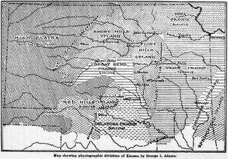 Kansas has been divided into eleven different physiographic regions.
. This area was part of the Tri-state district
of the nineteenth and twentieth centuries. Galena
was a center of lead
and zinc
mining
in the area.
, Crawford
and Bourbon Counties
. The lowlands are developed on areas of gently rolling hils developed on the shale and sandstone of the Cherokee Group of Pennsylvanian age. The Cherokee Group is noted for rich deposits of coal in Kansas and across the midwestern United States.
s are a region of east to southeast facing escarpment
s (50 to 200 feet high) formed on resistant limestone units which dip
gently to the west and northwest. Areas between escarpments are underlain by shales. The cuesta region contains coal, black shale and some oil shale
s. Lamproite
sills
occur within the cuesta units of Woodson
and Wilson counties
. These unusual igneous rock
s were intruded in the Cretaceous Period.
, Wilson
and Woodson counties
and the eastern edges of Chautauqua
, Elk
and Greenwood counties
. The sandstones continue into northern Oklahoma.
developed on the north-south exposure of Permian chert
y limestones. The region extends from Marshall County
in the north, to Cowley County
and on into northern Oklahoma where they are known as the Osage Hills
. The Permian limestones contain abundant weathering
resistant chert (or flint) and the residuum and soils of the hilltops and the streambeds of the region contain abundant cherty gravels. Surface exposures of the rare igneous kimberlite
s occur in Riley
and Marshall counties
. The kimberlite diatreme
s are of Cretaceous age. No diamonds have been found in the Kansas kimberlite occurrences. Garnet
crystals from the kimberlites have been reported in local stream gravels.
cover a section of southern Kansas in Clark
, Comanche
, and Barber counties
along the Oklahoma border. The Red Hills are named for their color derived from the Permian red beds which outcrop and underlie the region. The red color is produced by abundant iron oxide
s in the weathering sediments. The region is underlain by red shales, siltstones, and sandstones with along with interbedded dolomite
s and gypsum
evaporite
layers. Massive gypsum deposits are mined near Sun City
in northwestern Barber County. The Gyp Hills near Medicine Lodge
were named for the gypsum of the Blaine Formation. The soluble gypsum, anhydrite
and dolomite produce many cave
s in the area. The Big Basin
of Clark County
is a 2 km diameter, 35 m deep, dissolution collapse feature that formed by the dissolution of salt beds in the subsurface.
constitute a large area of north central Kansas. The area is underlain by Cretaceous sediments. Rocks outcroping in the area include the sandstones of the Dakota Formation
, the Greenhorn Limestone, and the thick Niobrara Chalk. Stratigraphically the Dakota is overlain by the Greenhorn and that by the Niobrara. The Dakota outcrops in the eastern portion of the region as gently westward dipping resistant ridges. Although the sandstones are the most resistant and therefor most prominent the Dakota includes shales and clays. The formation contains abundant brown iron oxides and many concretion
s are found in the area. In the western portions of the ares the bedrock is fossil
iferous chalk
of the Niobrara Formation which includes the Smoky Hill Chalk
member noted for abundant fish and marine reptile
fossils.
area. The highest point in Kansas, Mount Sunflower
(4039 feet (1,231 m)), is located in the High Plains physiographic region. The uplift
of the Rocky Mountains
during the Tertiary
resulted in erosion and deposition of vast quantities of non-marine sediments eastward across the High Plains. The Ogallala Formation
consists of a large wedge of unconsolidated sands and silts that is a significant aquifer
under the plains. The Ogallala contains a sandstone layer cemented with opal
. In the southwest corner of the state in Morton County
rocks of Jurassic
age outcrop along the Cimarron River. Loess
deposits cover much of the High Plains in north and northwest Kansas.
and east of the Big Blue River
,is covered by glacial
debris deposited during the Pre-Illinoian glaciations which occurred 600,000 years ago in the Pleistocene
. The Pennsylvanian and Permian bedrock is buried under thick deposits of glacial debris, largely loess. A variety of glacial erratic
s were left by the melting glaciers. Many of these are of Sioux Quartzite
carried south from the Sioux Falls, South Dakota
area.
, Sedgwick
, Harvey
and McPherson counties
is underlain by fluvial sediments deposited in the ancestral Arkansas River
valley during the Pleistocene Epoch one to two million years ago. The sediments consist largely of sands, silts and gravels. These include the "Equus beds" aquifer sediments, named for Pleistocene fossils it contains. Also under this area is the Permian Hutchinson salt bed which reaches a thickness of 400 feet. The area also contains inactive sand dunes.
through southwest and south-central Kansas. The broad floodplain contains large quantities of sand and silt carried from the Rocky Mountains by the river. A significant area of sand dunes occur on the south side of the plain formed by the prevailing winds from the glaciers to the north during the Pleistocene.
deposited on the Pre-Cambrian basement
of the North American Craton.
 Several regional subsurface structures including five sedimentary basin
s exist under Kansas. These structures are important in controlling the vast deposits of petroleum
and natural gas
in the state. The Central Kansas Uplift is a broad arch in the rocks of west central Kansas. The rock units within this arch have been major oil producers. The Anadarko Basin
of southwest Kansas contains significant natural gas. The Sedgwick Basin, the Cherokee Basin and the Forest City Basin of south and east Kansas also produce petroleum and natural gas.
is a deep fault zone which runs diagonally across east Kansas and extends from just south of Omaha, Nebraska
to Oklahoma City
. This fault zone directly overlies a granite
"high" in the Precambrian basement and is structurally active as the Humboldt Fault
. Some fifty miles to the west the southernmost extension of the Proterozoic
Midcontinent Rift System
extends into northeastern Kansas.
The northern two-thirds of Kansas is underlain by a Proterozoic sequence known as the Central Plains Orogen. The igneous and metamorphic rocks of this orogenic zone are considered to be an extension of the 1.7 Ga fold belt exposed in Colorado and Wyoming. The southern approximately one-third of the state is underlain by the Southern granite-rhyolite province dating to 1.35 to 1.48 Ga.
United States
The United States of America is a federal constitutional republic comprising fifty states and a federal district...
state of Kansas and the present-day rock
Rock (geology)
In geology, rock or stone is a naturally occurring solid aggregate of minerals and/or mineraloids.The Earth's outer solid layer, the lithosphere, is made of rock. In general rocks are of three types, namely, igneous, sedimentary, and metamorphic...
and soil
Soil
Soil is a natural body consisting of layers of mineral constituents of variable thicknesses, which differ from the parent materials in their morphological, physical, chemical, and mineralogical characteristics...
that is exposed there. Rock that crops out
Outcrop
An outcrop is a visible exposure of bedrock or ancient superficial deposits on the surface of the Earth. -Features:Outcrops do not cover the majority of the Earth's land surface because in most places the bedrock or superficial deposits are covered by a mantle of soil and vegetation and cannot be...
in Kansas was formed during the Phanerozoic eon, which consists of three geologic eras: the Paleozoic
Paleozoic
The Paleozoic era is the earliest of three geologic eras of the Phanerozoic eon, spanning from roughly...
, Mesozoic
Mesozoic
The Mesozoic era is an interval of geological time from about 250 million years ago to about 65 million years ago. It is often referred to as the age of reptiles because reptiles, namely dinosaurs, were the dominant terrestrial and marine vertebrates of the time...
and Cenozoic
Cenozoic
The Cenozoic era is the current and most recent of the three Phanerozoic geological eras and covers the period from 65.5 mya to the present. The era began in the wake of the Cretaceous–Tertiary extinction event at the end of the Cretaceous that saw the demise of the last non-avian dinosaurs and...
. Paleozoic rocks at the surface in Kansas are primarily from the Mississippian, Pennsylvanian
Pennsylvanian
The Pennsylvanian is, in the ICS geologic timescale, the younger of two subperiods of the Carboniferous Period. It lasted from roughly . As with most other geochronologic units, the rock beds that define the Pennsylvanian are well identified, but the exact date of the start and end are uncertain...
and Permian
Permian
The PermianThe term "Permian" was introduced into geology in 1841 by Sir Sir R. I. Murchison, president of the Geological Society of London, who identified typical strata in extensive Russian explorations undertaken with Edouard de Verneuil; Murchison asserted in 1841 that he named his "Permian...
periods.
Paleozoic Era
The oldest rocks at the surface in Kansas are Mississippian rocks that consist of limestoneLimestone
Limestone is a sedimentary rock composed largely of the minerals calcite and aragonite, which are different crystal forms of calcium carbonate . Many limestones are composed from skeletal fragments of marine organisms such as coral or foraminifera....
s, shale
Shale
Shale is a fine-grained, clastic sedimentary rock composed of mud that is a mix of flakes of clay minerals and tiny fragments of other minerals, especially quartz and calcite. The ratio of clay to other minerals is variable. Shale is characterized by breaks along thin laminae or parallel layering...
, dolomite
Dolomite
Dolomite is a carbonate mineral composed of calcium magnesium carbonate CaMg2. The term is also used to describe the sedimentary carbonate rock dolostone....
, chert
Chert
Chert is a fine-grained silica-rich microcrystalline, cryptocrystalline or microfibrous sedimentary rock that may contain small fossils. It varies greatly in color , but most often manifests as gray, brown, grayish brown and light green to rusty red; its color is an expression of trace elements...
, sandstone
Sandstone
Sandstone is a sedimentary rock composed mainly of sand-sized minerals or rock grains.Most sandstone is composed of quartz and/or feldspar because these are the most common minerals in the Earth's crust. Like sand, sandstone may be any colour, but the most common colours are tan, brown, yellow,...
s and siltstone
Siltstone
Siltstone is a sedimentary rock which has a grain size in the silt range, finer than sandstone and coarser than claystones.- Description :As its name implies, it is primarily composed of silt sized particles, defined as grains 1/16 - 1/256 mm or 4 to 8 on the Krumbein phi scale...
s. The Mississippian consisted of an environment similar to what we see today. Fast moving streams and rivers cutting into the limestone bedrock and in places creating caverns and sinkhole
Sinkhole
A sinkhole, also known as a sink, shake hole, swallow hole, swallet, doline or cenote, is a natural depression or hole in the Earth's surface caused by karst processes — the chemical dissolution of carbonate rocks or suffosion processes for example in sandstone...
s. Pennsylvanian rocks consist predominantly of alternating marine and non-marine shales and limestones with some sandstone, coal
Coal
Coal is a combustible black or brownish-black sedimentary rock usually occurring in rock strata in layers or veins called coal beds or coal seams. The harder forms, such as anthracite coal, can be regarded as metamorphic rock because of later exposure to elevated temperature and pressure...
, chert and conglomerate. The Pennsylvanian was a time that the region that is now eastern Kansas stayed nearly at sea level. Between the transgression and regression of the seas, swamps and bogs formed, depositing dead vegetation and later, after burial under younger sediments, this dead vegetation formed into coal. Permian rocks predominantly consist of limestones, shales and evaporite
Evaporite
Evaporite is a name for a water-soluble mineral sediment that result from concentration and crystallization by evaporation from an aqueous solution. There are two types of evaporate deposits, marine which can also be described as ocean deposits, and non-marine which are found in standing bodies of...
s. The Permian in Kansas began as an environment consisting of warm, shallow seas. As the Permian progressed, the climate became very dry and the seas began to subside, creating bodies of water shut off from the open seas, in turn creating areas for the generation of dark shales and evaporite minerals such as halite
Halite
Halite , commonly known as rock salt, is the mineral form of sodium chloride . Halite forms isometric crystals. The mineral is typically colorless or white, but may also be light blue, dark blue, purple, pink, red, orange, yellow or gray depending on the amount and type of impurities...
and gypsum
Gypsum
Gypsum is a very soft sulfate mineral composed of calcium sulfate dihydrate, with the chemical formula CaSO4·2H2O. It is found in alabaster, a decorative stone used in Ancient Egypt. It is the second softest mineral on the Mohs Hardness Scale...
as the waters evaporated. The end of the Permian marks the largest extinction period
Extinction event
An extinction event is a sharp decrease in the diversity and abundance of macroscopic life. They occur when the rate of extinction increases with respect to the rate of speciation...
in Earth's history; over 90% of all life disappeared.
Mesozoic Era
Mesozoic rocks at the surface in Kansas consist predominantly of rocks from the CretaceousCretaceous
The Cretaceous , derived from the Latin "creta" , usually abbreviated K for its German translation Kreide , is a geologic period and system from circa to million years ago. In the geologic timescale, the Cretaceous follows the Jurassic period and is followed by the Paleogene period of the...
. A relatively small outcrop of Jurassic
Jurassic
The Jurassic is a geologic period and system that extends from about Mya to Mya, that is, from the end of the Triassic to the beginning of the Cretaceous. The Jurassic constitutes the middle period of the Mesozoic era, also known as the age of reptiles. The start of the period is marked by...
sediments are exposed in the southwest corner of the state. Cretaceous age rocks consist of limestone
Limestone
Limestone is a sedimentary rock composed largely of the minerals calcite and aragonite, which are different crystal forms of calcium carbonate . Many limestones are composed from skeletal fragments of marine organisms such as coral or foraminifera....
, chalk
Chalk
Chalk is a soft, white, porous sedimentary rock, a form of limestone composed of the mineral calcite. Calcite is calcium carbonate or CaCO3. It forms under reasonably deep marine conditions from the gradual accumulation of minute calcite plates shed from micro-organisms called coccolithophores....
, shale and sandstone. The Cretaceous in Kansas was an open ocean or sea environment dominated by microscopic marine plants and animals that floated or swam near the surface of this ancient water body. As these microscopic creatures died they sank to the bottom, formed a soft, limy ooze and would preserve any larger creatures that would die and sink into it.
Cenozoic Era
Cenozoic rocks at the surface are made up of the TertiaryTertiary
The Tertiary is a deprecated term for a geologic period 65 million to 2.6 million years ago. The Tertiary covered the time span between the superseded Secondary period and the Quaternary...
and Quaternary
Quaternary
The Quaternary Period is the most recent of the three periods of the Cenozoic Era in the geologic time scale of the ICS. It follows the Neogene Period, spanning 2.588 ± 0.005 million years ago to the present...
periods. Tertiary rocks in Kansas consist of river silt, sand, freshwater limestones and some volcanic ash
Volcanic ash
Volcanic ash consists of small tephra, which are bits of pulverized rock and glass created by volcanic eruptions, less than in diameter. There are three mechanisms of volcanic ash formation: gas release under decompression causing magmatic eruptions; thermal contraction from chilling on contact...
derived from eruptions in the western United States. Near the beginning of the Tertiary, the Rocky Mountains
Rocky Mountains
The Rocky Mountains are a major mountain range in western North America. The Rocky Mountains stretch more than from the northernmost part of British Columbia, in western Canada, to New Mexico, in the southwestern United States...
were born, as were the streams and rivers heading eastward out from the mountains into Kansas. Over 60 million years of erosion
Erosion
Erosion is when materials are removed from the surface and changed into something else. It only works by hydraulic actions and transport of solids in the natural environment, and leads to the deposition of these materials elsewhere...
, the Rocky Mountains created a wedge of material extending to the Flint Hills
Flint Hills
The Flint Hills, historically known as Bluestem Pastures or Blue Stem Hills, are a band of hills in eastern Kansas stretching into north-central Oklahoma, extending from Marshall County, Kansas and Washington County, Kansas in the north to Cowley County, Kansas and Osage County, Oklahoma in the south...
of eastern Kansas. Quaternary rocks in Kansas consist of glacial drift; river silt, sand and gravel; dune
Dune
In physical geography, a dune is a hill of sand built by wind. Dunes occur in different forms and sizes, formed by interaction with the wind. Most kinds of dunes are longer on the windward side where the sand is pushed up the dune and have a shorter "slip face" in the lee of the wind...
sand and wind blown silt. The Quaternary Period in western Kansas was very similar to the Tertiary, continual erosion of the Rocky Mountains deposited additional sediments.
Physiographic regions
Ozark plateau
Mississippean limestones and cherts of the Ozark Plateau are exposed in extreme southeastern Kansas in Cherokee CountyCherokee County, Kansas
Cherokee County is a county located in Southeast Kansas, in the Central United States. As of the 2010 census, the county population was 21,603. Its county seat is Columbus, and its most populous city is Baxter Springs...
. This area was part of the Tri-state district
Tri-State district
The Tri-State district was an historic lead-zinc mining district located in southwest Missouri, southeast Kansas and northeast Oklahoma. The district produced lead and zinc for over 100 years. Production began in the 1850s and 60s in the Joplin - Granby area of Jasper and Newton counties of...
of the nineteenth and twentieth centuries. Galena
Galena, Kansas
Galena is a city in Cherokee County, Kansas, United States. As of the 2010 census, the city population was 3,085.-History:The city was named after the lead ore galena found here in 1877. The city was originally platted by the Galena Mining and Smelting Company and was to be known as Cornwall...
was a center of lead
Lead
Lead is a main-group element in the carbon group with the symbol Pb and atomic number 82. Lead is a soft, malleable poor metal. It is also counted as one of the heavy metals. Metallic lead has a bluish-white color after being freshly cut, but it soon tarnishes to a dull grayish color when exposed...
and zinc
Zinc
Zinc , or spelter , is a metallic chemical element; it has the symbol Zn and atomic number 30. It is the first element in group 12 of the periodic table. Zinc is, in some respects, chemically similar to magnesium, because its ion is of similar size and its only common oxidation state is +2...
mining
Mining
Mining is the extraction of valuable minerals or other geological materials from the earth, from an ore body, vein or seam. The term also includes the removal of soil. Materials recovered by mining include base metals, precious metals, iron, uranium, coal, diamonds, limestone, oil shale, rock...
in the area.
Cherokee lowlands
The Cherokee lowlands is a region of southeast Kansas immediately north and west of the Ozark plateau in Cherokee, LabetteLabette County, Kansas
Labette County is a county located in southeast Kansas, in the Central United States. As of the 2010 census, the county population was 21,607. Its county seat is Oswego, and its most populous city is Parsons...
, Crawford
Crawford County, Kansas
Crawford County is a county located in southeastern Kansas in the United States. As of the 2010 census, the county population was 39,134. Its county seat is Girard, and its most populous city is Pittsburg. The county was named in honor of Samuel J. Crawford, Governor of Kansas...
and Bourbon Counties
Bourbon County, Kansas
Bourbon County is a county located in Southeast Kansas, in the Central United States. As of the 2010 census, the county population was 15,173...
. The lowlands are developed on areas of gently rolling hils developed on the shale and sandstone of the Cherokee Group of Pennsylvanian age. The Cherokee Group is noted for rich deposits of coal in Kansas and across the midwestern United States.
Osage Cuestas
The Osage cuesta region underlies twenty counties in southeastern Kansas. The cuestaCuesta
In structural geology and geomorphology, a cuesta is a ridge formed by gently tilted sedimentary rock strata in a homoclinal structure. Cuestas have a steep slope, where the rock layers are exposed on their edges, called an escarpment or, if more steep, a cliff...
s are a region of east to southeast facing escarpment
Escarpment
An escarpment is a steep slope or long cliff that occurs from erosion or faulting and separates two relatively level areas of differing elevations.-Description and variants:...
s (50 to 200 feet high) formed on resistant limestone units which dip
Strike and dip
Strike and dip refer to the orientation or attitude of a geologic feature. The strike line of a bed, fault, or other planar feature is a line representing the intersection of that feature with a horizontal plane. On a geologic map, this is represented with a short straight line segment oriented...
gently to the west and northwest. Areas between escarpments are underlain by shales. The cuesta region contains coal, black shale and some oil shale
Oil shale
Oil shale, an organic-rich fine-grained sedimentary rock, contains significant amounts of kerogen from which liquid hydrocarbons called shale oil can be produced...
s. Lamproite
Lamproite
Lamproites are ultrapotassic mantle-derived volcanic and subvolcanic rocks. They have low CaO, Al2O3, Na2O, high K2O/Al2O3, a relatively high MgO content and extreme enrichment in incompatible elements....
sills
Sill (geology)
In geology, a sill is a tabular sheet intrusion that has intruded between older layers of sedimentary rock, beds of volcanic lava or tuff, or even along the direction of foliation in metamorphic rock. The term sill is synonymous with concordant intrusive sheet...
occur within the cuesta units of Woodson
Woodson County, Kansas
Woodson County is a county located in the U.S. state of Kansas. As of the 2010 census, the county population was 3,309...
and Wilson counties
Wilson County, Kansas
Wilson County is a county located in the U.S. state of Kansas. As of the 2010 census, the county population was 9,409...
. These unusual igneous rock
Igneous rock
Igneous rock is one of the three main rock types, the others being sedimentary and metamorphic rock. Igneous rock is formed through the cooling and solidification of magma or lava...
s were intruded in the Cretaceous Period.
Chautauqua Hills
The Chautauqua Hills represent a narrow region in southeast Kansas of sandstone capped ridges and rolling hills. The Pennsylvanian age sandstones were depositied in a large river valley. The sandstones are the Tonganoxie Sandstone Member of the Stranger Formation and Ireland Sandstone Member of the Lawrence Formation. The hills occur in the western portions of MontgomeryMontgomery County, Kansas
Montgomery County is a county located in southeast Kansas, in the Central United States. As of the 2010 census, the county population was 35,471. Its county seat is Independence, and its most populous city is Coffeyville. The Coffeyville Micropolitan Statistical Area includes all of Montgomery...
, Wilson
Wilson County, Kansas
Wilson County is a county located in the U.S. state of Kansas. As of the 2010 census, the county population was 9,409...
and Woodson counties
Woodson County, Kansas
Woodson County is a county located in the U.S. state of Kansas. As of the 2010 census, the county population was 3,309...
and the eastern edges of Chautauqua
Chautauqua County, Kansas
Chautauqua County is a county located in Southeast Kansas, in the Central United States. As of the 2010 census, the county population was 3,669. Its county seat and most populous city is Sedan...
, Elk
Elk County, Kansas
Elk County is a county located in Southeast Kansas, in the Central United States. As of the 2010 census, the county population was 2,882...
and Greenwood counties
Greenwood County, Kansas
Greenwood County is a county located in Southeast Kansas, in the Central United States. As of the 2010 census, the county population was 6,689...
. The sandstones continue into northern Oklahoma.
Flint Hills
The Flint HillsFlint Hills
The Flint Hills, historically known as Bluestem Pastures or Blue Stem Hills, are a band of hills in eastern Kansas stretching into north-central Oklahoma, extending from Marshall County, Kansas and Washington County, Kansas in the north to Cowley County, Kansas and Osage County, Oklahoma in the south...
developed on the north-south exposure of Permian chert
Chert
Chert is a fine-grained silica-rich microcrystalline, cryptocrystalline or microfibrous sedimentary rock that may contain small fossils. It varies greatly in color , but most often manifests as gray, brown, grayish brown and light green to rusty red; its color is an expression of trace elements...
y limestones. The region extends from Marshall County
Marshall County, Kansas
Marshall County is a county located in the U.S. state of Kansas. As of the 2010 census, the county population was 10,117. The largest city and county seat is Marysville.- History :...
in the north, to Cowley County
Cowley County, Kansas
Cowley County is a county located in south-central Kansas, in the Central United States. As of the 2010 census, the county population was 36,311. Its county seat and most populous city is Winfield...
and on into northern Oklahoma where they are known as the Osage Hills
Osage Hills
The Osage Hills are a small range of hills in Oklahoma, commonly known as The Osage, refers to the broad rolling hills and rolling tallgrass prairie and Cross Timbers encompassing Osage County and surrounding areas, including portions of Mayes, Tulsa and Washington Counties.-The Osage:The Osage...
. The Permian limestones contain abundant weathering
Weathering
Weathering is the breaking down of rocks, soils and minerals as well as artificial materials through contact with the Earth's atmosphere, biota and waters...
resistant chert (or flint) and the residuum and soils of the hilltops and the streambeds of the region contain abundant cherty gravels. Surface exposures of the rare igneous kimberlite
Kimberlite
Kimberlite is a type of potassic volcanic rock best known for sometimes containing diamonds. It is named after the town of Kimberley in South Africa, where the discovery of an diamond in 1871 spawned a diamond rush, eventually creating the Big Hole....
s occur in Riley
Riley County, Kansas
Riley County is a county located in the U.S. state of Kansas. The county's population was 71,115 for the 2010 census. The largest city and county seat is Manhattan. The county is part of the Manhattan, Kansas, Metropolitan Statistical Area.Riley County is home to two of Kansas' largest...
and Marshall counties
Marshall County, Kansas
Marshall County is a county located in the U.S. state of Kansas. As of the 2010 census, the county population was 10,117. The largest city and county seat is Marysville.- History :...
. The kimberlite diatreme
Diatreme
A diatreme is a breccia-filled volcanic pipe that was formed by a gaseous explosion. Diatremes often breach the surface and produce a tuff cone, a filled relatively shallow crater known as a maar, or other volcanic pipes.- Word origin :...
s are of Cretaceous age. No diamonds have been found in the Kansas kimberlite occurrences. Garnet
Garnet
The garnet group includes a group of minerals that have been used since the Bronze Age as gemstones and abrasives. The name "garnet" may come from either the Middle English word gernet meaning 'dark red', or the Latin granatus , possibly a reference to the Punica granatum , a plant with red seeds...
crystals from the kimberlites have been reported in local stream gravels.
Red Hills
The Red HillsRed Hills
The Red Hills is the name of a physiographic region located mostly in Clark, Comanche and Barber counties in southern and central Kansas. This undulating terrain of red-tinted sediments, a product of the underlying geology, does not fit the conventional description of the Great Plains landscape of...
cover a section of southern Kansas in Clark
Clark County, Kansas
Clark County is a county located in Southwest Kansas, in the Central United States. As of the 2010 census, the county population was 2,215...
, Comanche
Comanche County, Kansas
Comanche County is a county located in Southwest Kansas, in the Central United States. As of the 2010 census, the county population was 1,891...
, and Barber counties
Barber County, Kansas
Barber County is a county located in South Central Kansas, in the Central United States. As of the 2010 census, the county population was 4,861. Its county seat and most populous city is Medicine Lodge...
along the Oklahoma border. The Red Hills are named for their color derived from the Permian red beds which outcrop and underlie the region. The red color is produced by abundant iron oxide
Iron oxide
Iron oxides are chemical compounds composed of iron and oxygen. All together, there are sixteen known iron oxides and oxyhydroxides.Iron oxides and oxide-hydroxides are widespread in nature, play an important role in many geological and biological processes, and are widely utilized by humans, e.g.,...
s in the weathering sediments. The region is underlain by red shales, siltstones, and sandstones with along with interbedded dolomite
Dolomite
Dolomite is a carbonate mineral composed of calcium magnesium carbonate CaMg2. The term is also used to describe the sedimentary carbonate rock dolostone....
s and gypsum
Gypsum
Gypsum is a very soft sulfate mineral composed of calcium sulfate dihydrate, with the chemical formula CaSO4·2H2O. It is found in alabaster, a decorative stone used in Ancient Egypt. It is the second softest mineral on the Mohs Hardness Scale...
evaporite
Evaporite
Evaporite is a name for a water-soluble mineral sediment that result from concentration and crystallization by evaporation from an aqueous solution. There are two types of evaporate deposits, marine which can also be described as ocean deposits, and non-marine which are found in standing bodies of...
layers. Massive gypsum deposits are mined near Sun City
Sun City, Kansas
Sun City is a city in Barber County, Kansas, United States, along the Medicine Lodge River. As of the 2010 census, the city population was 53.-Geography:Sun City is located at...
in northwestern Barber County. The Gyp Hills near Medicine Lodge
Medicine Lodge, Kansas
Medicine Lodge is the most populous city in and the county seat of Barber County, Kansas, United States. As of the 2010 census, the city population was 2,009.-19th century:...
were named for the gypsum of the Blaine Formation. The soluble gypsum, anhydrite
Anhydrite
Anhydrite is a mineral – anhydrous calcium sulfate, CaSO4. It is in the orthorhombic crystal system, with three directions of perfect cleavage parallel to the three planes of symmetry. It is not isomorphous with the orthorhombic barium and strontium sulfates, as might be expected from the...
and dolomite produce many cave
Cave
A cave or cavern is a natural underground space large enough for a human to enter. The term applies to natural cavities some part of which is in total darkness. The word cave also includes smaller spaces like rock shelters, sea caves, and grottos.Speleology is the science of exploration and study...
s in the area. The Big Basin
Big Basin Prairie Preserve
The Big Basin Prairie Preserve is a nature preserve owned and managed by the Kansas Department of Wildlife and Parks. The preserve is in the Red Hills near Ashland in Clark County, Kansas. The main features are St. Jacob's Well, a water-filled sinkhole which lies in the Little Basin, and the Big...
of Clark County
Clark County, Kansas
Clark County is a county located in Southwest Kansas, in the Central United States. As of the 2010 census, the county population was 2,215...
is a 2 km diameter, 35 m deep, dissolution collapse feature that formed by the dissolution of salt beds in the subsurface.
Smoky Hills
The Smoky HillsSmoky Hills
The Smoky Hills are an upland region of hills in the central Great Plains of North America. They are located in the central United States, encompassing north-central Kansas and a small portion of south-central Nebraska. The hills are a dissected plain covered by tallgrass and mixed-grass prairie...
constitute a large area of north central Kansas. The area is underlain by Cretaceous sediments. Rocks outcroping in the area include the sandstones of the Dakota Formation
Dakota Formation
The Dakota Formation is a geologic formation composed of sedimentary rocks deposited on the western side of the Late Cretaceous Western Interior Seaway. F.B. Meek and F.V. Hayden named it for exposures along the Missouri River near Dakota City, Nebraska...
, the Greenhorn Limestone, and the thick Niobrara Chalk. Stratigraphically the Dakota is overlain by the Greenhorn and that by the Niobrara. The Dakota outcrops in the eastern portion of the region as gently westward dipping resistant ridges. Although the sandstones are the most resistant and therefor most prominent the Dakota includes shales and clays. The formation contains abundant brown iron oxides and many concretion
Concretion
A concretion is a volume of sedimentary rock in which a mineral cement fills the porosity . Concretions are often ovoid or spherical in shape, although irregular shapes also occur. The word 'concretion' is derived from the Latin con meaning 'together' and crescere meaning 'to grow'...
s are found in the area. In the western portions of the ares the bedrock is fossil
Fossil
Fossils are the preserved remains or traces of animals , plants, and other organisms from the remote past...
iferous chalk
Chalk
Chalk is a soft, white, porous sedimentary rock, a form of limestone composed of the mineral calcite. Calcite is calcium carbonate or CaCO3. It forms under reasonably deep marine conditions from the gradual accumulation of minute calcite plates shed from micro-organisms called coccolithophores....
of the Niobrara Formation which includes the Smoky Hill Chalk
Smoky Hill Chalk
The Smoky Hill Chalk Member of the Niobrara Chalk formation is a Cretaceous conservation Lagerstätte, or fossil rich geological formation, known primarily for its exceptionally well-preserved marine reptiles. The Smoky Hill Chalk Member is the uppermost of the two structural units of the Niobrara...
member noted for abundant fish and marine reptile
Marine reptile
Marine reptiles are reptiles which have become secondarily adapted for an aquatic or semi-aquatic life in a marine environment.The earliest marine reptiles arose in the Permian period during the Paleozoic era...
fossils.
High Plains
The western third of Kansas is in the High PlainsHigh Plains (United States)
The High Plains are a subregion of the Great Plains mostly in the Western United States, but also partly in the Midwest states of Nebraska, Kansas, and South Dakota, generally encompassing the western part of the Great Plains before the region reaches the Rocky Mountains...
area. The highest point in Kansas, Mount Sunflower
Mount Sunflower
Mount Sunflower is the highest natural point in the state of Kansas. At , it is above the state's topographic low point in Montgomery County in southeastern Kansas due to the gradual rise towards the Rocky Mountains to the west...
(4039 feet (1,231 m)), is located in the High Plains physiographic region. The uplift
Tectonic uplift
Tectonic uplift is a geological process most often caused by plate tectonics which increases elevation. The opposite of uplift is subsidence, which results in a decrease in elevation. Uplift may be orogenic or isostatic.-Orogenic uplift:...
of the Rocky Mountains
Rocky Mountains
The Rocky Mountains are a major mountain range in western North America. The Rocky Mountains stretch more than from the northernmost part of British Columbia, in western Canada, to New Mexico, in the southwestern United States...
during the Tertiary
Tertiary
The Tertiary is a deprecated term for a geologic period 65 million to 2.6 million years ago. The Tertiary covered the time span between the superseded Secondary period and the Quaternary...
resulted in erosion and deposition of vast quantities of non-marine sediments eastward across the High Plains. The Ogallala Formation
Ogallala Aquifer
The Ogallala Aquifer, also known as the High Plains Aquifer, is a vast yet shallow underground water table aquifer located beneath the Great Plains in the United States...
consists of a large wedge of unconsolidated sands and silts that is a significant aquifer
Aquifer
An aquifer is a wet underground layer of water-bearing permeable rock or unconsolidated materials from which groundwater can be usefully extracted using a water well. The study of water flow in aquifers and the characterization of aquifers is called hydrogeology...
under the plains. The Ogallala contains a sandstone layer cemented with opal
Opal
Opal is an amorphous form of silica related to quartz, a mineraloid form, not a mineral. 3% to 21% of the total weight is water, but the content is usually between 6% to 10%. It is deposited at a relatively low temperature and may occur in the fissures of almost any kind of rock, being most...
. In the southwest corner of the state in Morton County
Morton County, Kansas
Morton County is a county located in the U.S. state of Kansas. As of the 2010 census, the county population was 3,233...
rocks of Jurassic
Jurassic
The Jurassic is a geologic period and system that extends from about Mya to Mya, that is, from the end of the Triassic to the beginning of the Cretaceous. The Jurassic constitutes the middle period of the Mesozoic era, also known as the age of reptiles. The start of the period is marked by...
age outcrop along the Cimarron River. Loess
Loess
Loess is an aeolian sediment formed by the accumulation of wind-blown silt, typically in the 20–50 micrometre size range, twenty percent or less clay and the balance equal parts sand and silt that are loosely cemented by calcium carbonate...
deposits cover much of the High Plains in north and northwest Kansas.
Glaciated Region
The northeast corner of the state, north of the Kansas RiverKansas River
The Kansas River is a river in northeastern Kansas in the United States. It is the southwestern-most part of the Missouri River drainage, which is in turn the northwestern-most portion of the extensive Mississippi River drainage. Its name come from the Kanza people who once inhabited the area...
and east of the Big Blue River
Big Blue River (Kansas)
The Big Blue River is the largest tributary of the Kansas River. The river flows for approximately from central Nebraska into Kansas, where it intersects with the Kansas River east of Manhattan. It was given its name by the Kansa tribe of Native Americans, who lived at its mouth from 1780 to...
,is covered by glacial
Glacier
A glacier is a large persistent body of ice that forms where the accumulation of snow exceeds its ablation over many years, often centuries. At least 0.1 km² in area and 50 m thick, but often much larger, a glacier slowly deforms and flows due to stresses induced by its weight...
debris deposited during the Pre-Illinoian glaciations which occurred 600,000 years ago in the Pleistocene
Pleistocene
The Pleistocene is the epoch from 2,588,000 to 11,700 years BP that spans the world's recent period of repeated glaciations. The name pleistocene is derived from the Greek and ....
. The Pennsylvanian and Permian bedrock is buried under thick deposits of glacial debris, largely loess. A variety of glacial erratic
Glacial erratic
A glacial erratic is a piece of rock that differs from the size and type of rock native to the area in which it rests. "Erratics" take their name from the Latin word errare, and are carried by glacial ice, often over distances of hundreds of kilometres...
s were left by the melting glaciers. Many of these are of Sioux Quartzite
Sioux Quartzite
The Sioux Quartzite is a Proterozoic quartzite that is found in region around the intersection of Minnesota, South Dakota, and Iowa, and correlates with other rock units throughout the upper midwestern and southwestern United States...
carried south from the Sioux Falls, South Dakota
Sioux Falls, South Dakota
Sioux Falls is the largest city in the U.S. state of South Dakota. Sioux Falls is the county seat of Minnehaha County, and also extends into Lincoln County to the south...
area.
Wellington-McPherson Lowlands
The Wellington-McPherson Lowlands of south central Kansas in SumnerSumner County, Kansas
Sumner County is a county located in the U.S. state of Kansas. The county's population was 24,132 for the 2010 census. Its county seat is Wellington. Sumner County is part of the Wichita, Kansas Metropolitan Statistical Area. It was named in honor of Charles Sumner, a U.S...
, Sedgwick
Sedgwick County, Kansas
Sedgwick County is a county located in the U.S. state of Kansas. The county's population was 498,365 for the 2010 census. The largest city and county seat is Wichita. The county was named after General John Sedgwick...
, Harvey
Harvey County, Kansas
Harvey County is a county located in South Central Kansas, in the Central United States. As of the 2010 census, the county population was 34,684. Its county seat and most populous city is Newton. The county is a part of the Wichita Metropolitan Statistical Area which also includes Butler,...
and McPherson counties
McPherson County, Kansas
McPherson County is a county located in the U.S. state of Kansas. As of the 2010 census, the county population was 29,180. The largest city and county seat is McPherson. The county is named for Civil War General James B. McPherson...
is underlain by fluvial sediments deposited in the ancestral Arkansas River
Arkansas River
The Arkansas River is a major tributary of the Mississippi River. The Arkansas generally flows to the east and southeast as it traverses the U.S. states of Colorado, Kansas, Oklahoma, and Arkansas. The river's initial basin starts in the Western United States in Colorado, specifically the Arkansas...
valley during the Pleistocene Epoch one to two million years ago. The sediments consist largely of sands, silts and gravels. These include the "Equus beds" aquifer sediments, named for Pleistocene fossils it contains. Also under this area is the Permian Hutchinson salt bed which reaches a thickness of 400 feet. The area also contains inactive sand dunes.
Arkansas River Lowlands
The Arkansas River Lowlands follows the course of the Arkansas RiverArkansas River
The Arkansas River is a major tributary of the Mississippi River. The Arkansas generally flows to the east and southeast as it traverses the U.S. states of Colorado, Kansas, Oklahoma, and Arkansas. The river's initial basin starts in the Western United States in Colorado, specifically the Arkansas...
through southwest and south-central Kansas. The broad floodplain contains large quantities of sand and silt carried from the Rocky Mountains by the river. A significant area of sand dunes occur on the south side of the plain formed by the prevailing winds from the glaciers to the north during the Pleistocene.
Subsurface geology
The subsurface geology of Kansas consists of several sequences of sedimentary strataStratum
In geology and related fields, a stratum is a layer of sedimentary rock or soil with internally consistent characteristics that distinguish it from other layers...
deposited on the Pre-Cambrian basement
Basement (geology)
In geology, the terms basement and crystalline basement are used to define the rocks below a sedimentary platform or cover, or more generally any rock below sedimentary rocks or sedimentary basins that are metamorphic or igneous in origin...
of the North American Craton.
Sedimentary basin
The term sedimentary basin is used to refer to any geographical feature exhibiting subsidence and consequent infilling by sedimentation. As the sediments are buried, they are subjected to increasing pressure and begin the process of lithification...
s exist under Kansas. These structures are important in controlling the vast deposits of petroleum
Petroleum
Petroleum or crude oil is a naturally occurring, flammable liquid consisting of a complex mixture of hydrocarbons of various molecular weights and other liquid organic compounds, that are found in geologic formations beneath the Earth's surface. Petroleum is recovered mostly through oil drilling...
and natural gas
Natural gas
Natural gas is a naturally occurring gas mixture consisting primarily of methane, typically with 0–20% higher hydrocarbons . It is found associated with other hydrocarbon fuel, in coal beds, as methane clathrates, and is an important fuel source and a major feedstock for fertilizers.Most natural...
in the state. The Central Kansas Uplift is a broad arch in the rocks of west central Kansas. The rock units within this arch have been major oil producers. The Anadarko Basin
Anadarko Basin
The Anadarko Basin is a geologic depositional and structural basin centered in the western part of the state of Oklahoma and the Texas Panhandle, and extending into western Kansas and southeast Colorado.-Geology:...
of southwest Kansas contains significant natural gas. The Sedgwick Basin, the Cherokee Basin and the Forest City Basin of south and east Kansas also produce petroleum and natural gas.
Proterozoic basement
The Nemaha upliftNemaha Ridge
The Nemaha Ridge is located in the Central United States. It is a buried structural zone associated with a granite high in the Pre-Cambrian basement that extends from approximately Omaha, Nebraska to Oklahoma City, Oklahoma. The ridge is associated with the seismically active Humboldt Fault zone...
is a deep fault zone which runs diagonally across east Kansas and extends from just south of Omaha, Nebraska
Omaha, Nebraska
Omaha is the largest city in the state of Nebraska, United States, and is the county seat of Douglas County. It is located in the Midwestern United States on the Missouri River, about 20 miles north of the mouth of the Platte River...
to Oklahoma City
Oklahoma city
Oklahoma City is the capital and largest city of the U.S. state of Oklahoma.Oklahoma City may also refer to:*Oklahoma City metropolitan area*Downtown Oklahoma City*Uptown Oklahoma City*Oklahoma City bombing*Oklahoma City National Memorial...
. This fault zone directly overlies a granite
Granite
Granite is a common and widely occurring type of intrusive, felsic, igneous rock. Granite usually has a medium- to coarse-grained texture. Occasionally some individual crystals are larger than the groundmass, in which case the texture is known as porphyritic. A granitic rock with a porphyritic...
"high" in the Precambrian basement and is structurally active as the Humboldt Fault
Humboldt Fault
The Humboldt Fault or Humboldt Fault Zone, is a normal fault or series of faults, that extends from Nebraska southwestwardly through most of Kansas....
. Some fifty miles to the west the southernmost extension of the Proterozoic
Proterozoic
The Proterozoic is a geological eon representing a period before the first abundant complex life on Earth. The name Proterozoic comes from the Greek "earlier life"...
Midcontinent Rift System
Midcontinent Rift System
The Midcontinent Rift System or Keweenawan Rift is a long geological rift in the center of the North American continent and south-central part of the North American plate. It formed when the continent's core, the North American craton, began to split apart during the Mesoproterozoic era of the...
extends into northeastern Kansas.
The northern two-thirds of Kansas is underlain by a Proterozoic sequence known as the Central Plains Orogen. The igneous and metamorphic rocks of this orogenic zone are considered to be an extension of the 1.7 Ga fold belt exposed in Colorado and Wyoming. The southern approximately one-third of the state is underlain by the Southern granite-rhyolite province dating to 1.35 to 1.48 Ga.