

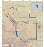
Powder River Basin
Encyclopedia
Montana
Montana is a state in the Western United States. The western third of Montana contains numerous mountain ranges. Smaller, "island ranges" are found in the central third of the state, for a total of 77 named ranges of the Rocky Mountains. This geographical fact is reflected in the state's name,...
and northeast Wyoming
Wyoming
Wyoming is a state in the mountain region of the Western United States. The western two thirds of the state is covered mostly with the mountain ranges and rangelands in the foothills of the Eastern Rocky Mountains, while the eastern third of the state is high elevation prairie known as the High...
, about 120 miles (193.1 km) east to west and 200 miles (321.9 km) north to south, known for its coal
Coal
Coal is a combustible black or brownish-black sedimentary rock usually occurring in rock strata in layers or veins called coal beds or coal seams. The harder forms, such as anthracite coal, can be regarded as metamorphic rock because of later exposure to elevated temperature and pressure...
deposits. The region supplies about 40 percent of coal in the United States. It is both a topographic drainage and geologic structural basin. The basin is so named because it is drained by the Powder River
Powder River (Montana)
Powder River is a tributary of the Yellowstone River, approximately long in the southeastern Montana and northeastern Wyoming in the United States. It drains an area historically known as the Powder River Country on the high plains east of the Bighorn Mountains.It rises in three forks in eastern...
, although it is also drained in part by the Cheyenne River
Cheyenne River
The Cheyenne River is a tributary of the Missouri River in the U.S. states of Wyoming and South Dakota. It is approximately 295 mi long and drains an area of...
, Tongue River, Bighorn River
Bighorn River
The Bighorn River is a tributary of the Yellowstone, approximately long, in the western United States in the states of Wyoming and Montana. The river was named in 1805 by fur trader François Larocque for the Bighorn Sheep he saw along its banks as he explored the Yellowstone River.The upper...
, Little Missouri River
Little Missouri River (North Dakota)
The Little Missouri River is a tributary of the Missouri River, 560 mi long, in the northern Great Plains of the United States. Rising in northeastern Wyoming, in western Crook County about west of Devil's Tower, it flows northeastward, across a corner of southeastern Montana, and into South Dakota...
, Platte River
Platte River
The Platte River is a major river in the state of Nebraska and is about long. Measured to its farthest source via its tributary the North Platte River, it flows for over . The Platte River is a tributary of the Missouri River, which in turn is a tributary of the Mississippi River which flows to...
, and their tributaries.
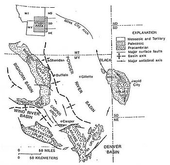
While the Powder River Basin is unified geologically, residents of areas distant from the Powder River proper do not think of themselves as living in a single geographic region. For example, residents of the Crow Reservation in the Big Horn River watershed, or of Sheridan in the Tongue River watershed, would locate the Powder River Basin as the region east of the Big Horn Mountains, using a definition based on watershed and topography.
Major cities in the area include Gillette
Gillette, Wyoming
Gillette is a city in and the county seat of Campbell County, Wyoming, United States. The population was 29,087 in 2010. Gillette is a city centrally located in an area involved with the development of vast quantities of American coal, oil, and coal bed methane gas...
and Sheridan, Wyoming
Sheridan, Wyoming
Sheridan is a city in Sheridan County, Wyoming, United States. The 2010 census put the population at 17,444 and a Micropolitan Statistical Area of 29,116...
and Miles City, Montana
Miles City, Montana
Miles City is a city in and the county seat of Custer County, Montana, United States. The population was 8,123 at the 2010 census.- History :...
. Outside of these main towns, the area is very sparsely populated and is known for its rolling grasslands and semiarid climate.
It is the single largest source of coal mined in the United States
United States
The United States of America is a federal constitutional republic comprising fifty states and a federal district...
, and contains one of the largest deposits of coal in the world. Most of the active coal mining in the Powder River Basin actually takes place in drainages of the Cheyenne River
Cheyenne River
The Cheyenne River is a tributary of the Missouri River in the U.S. states of Wyoming and South Dakota. It is approximately 295 mi long and drains an area of...
. Because of the Powder River Basin, Wyoming has been the top coal-producing state in the United States since 1988. In 2007, the Powder River Basin alone produced 436 million short tons (396 million tonnes) of coal, more than twice the production of second-place West Virginia
West Virginia
West Virginia is a state in the Appalachian and Southeastern regions of the United States, bordered by Virginia to the southeast, Kentucky to the southwest, Ohio to the northwest, Pennsylvania to the northeast and Maryland to the east...
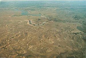
, and more than the entire Appalachian region. The Black Thunder Coal Mine
Black Thunder Coal Mine
The Black Thunder Coal Mine is a surface coal mine in the U.S. state of Wyoming, located at in the Powder River Basin which contains one of the largest deposits of coal in the world. Black Thunder is the second most productive mine in the United States and one of the largest in the world,...
is the most productive coal mine in the United States; in 2006 this single mine produced 84 million metric tons of coal, more than any state except Wyoming, West Virginia, and Kentucky
Kentucky
The Commonwealth of Kentucky is a state located in the East Central United States of America. As classified by the United States Census Bureau, Kentucky is a Southern state, more specifically in the East South Central region. Kentucky is one of four U.S. states constituted as a commonwealth...
. The region is also a major producer of natural gas through a process called coal-bed methane extraction. Underground coal seams are dewatered through pumping, which reduces pressure and releases trapped gases up to the well head.
Geologic history
Phanerozoic
The Phanerozoic Eon is the current eon in the geologic timescale, and the one during which abundant animal life has existed. It covers roughly 542 million years and goes back to the time when diverse hard-shelled animals first appeared...
rocks up to 17000 feet (5,181.6 m) thick, from Cambrian
Cambrian
The Cambrian is the first geological period of the Paleozoic Era, lasting from Mya ; it is succeeded by the Ordovician. Its subdivisions, and indeed its base, are somewhat in flux. The period was established by Adam Sedgwick, who named it after Cambria, the Latin name for Wales, where Britain's...
to Holocene
Holocene
The Holocene is a geological epoch which began at the end of the Pleistocene and continues to the present. The Holocene is part of the Quaternary period. Its name comes from the Greek words and , meaning "entirely recent"...
.
Cretaceous
The thickest section of the Powder River Basin is composed of CretaceousCretaceous
The Cretaceous , derived from the Latin "creta" , usually abbreviated K for its German translation Kreide , is a geologic period and system from circa to million years ago. In the geologic timescale, the Cretaceous follows the Jurassic period and is followed by the Paleogene period of the...
rocks, an overall regressive sequence of mostly marine shales and sandstones deposited in the Western Interior Seaway
Western Interior Seaway
The Western Interior Seaway, also called the Cretaceous Seaway, the Niobraran Sea, and the North American Inland Sea, was a huge inland sea that split the continent of North America into two halves, Laramidia and Appalachia, during most of the mid- and late-Cretaceous Period...
.
Tertiary
The coal beds of the region began to form about 60 million years ago when the land began rising from a shallow sea. The rise of the Black HillsBlack Hills
The Black Hills are a small, isolated mountain range rising from the Great Plains of North America in western South Dakota and extending into Wyoming, USA. Set off from the main body of the Rocky Mountains, the region is something of a geological anomaly—accurately described as an "island of...
uplift on the east and the Hartville uplift on the southeast side of the basin created the present outline of the Powder River Basin.
When the coal beds were forming, the climate in the area was subtropical, averaging about 120 inches (3,048 mm) of rainfall a year. For some 25 million years, the basin floor was covered with lakes and swamps. Because of the large area of the swamps, the organic material accumulated into peat bogs instead of being washed to the sea. Periodically the layers of peat were covered with sediments washed in from nearby mountains. Eventually the climate became drier and cooler. The basin filled with sediment and buried the peat under thousands of feet, compressing the layers of peat and forming coal. Over the last several million years, much of the overlying sediment has eroded away, leaving the coal seams near the surface.
Coal
Powder River Basin coal is classified as "sub-bituminousSub-bituminous coal
Sub-bituminous coal is a type of coal whose properties range from those of lignite to those of bituminous coal and are used primarily as fuel for steam-electric power generation.- Properties:...
" and contains an average of approximately 8,500 btu/lb, with low SO2
Sulfur dioxide
Sulfur dioxide is the chemical compound with the formula . It is released by volcanoes and in various industrial processes. Since coal and petroleum often contain sulfur compounds, their combustion generates sulfur dioxide unless the sulfur compounds are removed before burning the fuel...
. Contrast this with eastern, Appalachia
Appalachia
Appalachia is a term used to describe a cultural region in the eastern United States that stretches from the Southern Tier of New York state to northern Alabama, Mississippi, and Georgia. While the Appalachian Mountains stretch from Belle Isle in Canada to Cheaha Mountain in the U.S...
n bituminous coal
Bituminous coal
Bituminous coal or black coal is a relatively soft coal containing a tarlike substance called bitumen. It is of higher quality than lignite coal but of poorer quality than Anthracite...
containing an average of 12,500 btu/lb and high SO2. PRB coal was essentially worthless until air pollution emissions from power plants became a concern. A coal-fired plant designed to burn Appalachian coal must be modified to remove SO2 at a cost estimated in 1999 to be around $113 per ton of SO2 removal if it switches to burning PRB coal, and $322 per ton of SO2 removal by installing scrubbers.
The United States Geological Survey (USGS) has conducted a series of studies on the economic accessibility of coal in the major coal producing regions of the country. The studies have typically found that only a small fraction of the coal will be economically accessible at the current price of $10.47/ton. In August 2008, the USGS issued an updated assessment of coal in the Powder River Basin. After considering stripping ratios and production costs, the USGS concluded that at the time of the economic evaluation, only 6 percent of the original resource, or 10.1 billion short tons of coal, was currently economically recoverable. At a price of $60/ton, roughly half (48%) of the coal is economic to produce.
Presently the approximately 15 mines in the Powder River Basin are working in areas where the stripping ratio is between 1:1 (i.e. one ton of rock for one ton of coal) and 3:1. As the mines expand the stripping ratio will increase. As more rock needs to be moved (using large electrically powered draglines and diesel and electric mining trucks) the production cost will also increase.
The United States uses about 1 billion tons of coal a year, with about 40 percent of the coal currently coming from the Powder River Basin. The amount of coal coming from the Powder River Basin has been increasing over the last 20 years.
Increasing the price paid for coal can increase the amount of economically recoverable coal, but increasing the price of coal will also increase the production cost for the coal. In addition, because coal is a solid, not a liquid, it cannot be produced from many scattered wells as oil and gas can be. Rather, coal has to be produced from mines that expand slowly by moving massive quantities of overburden.
The mines in the Powder River Basin typically have less than 20 years of life remaining. Almost all of the coal in the Powder River Basin is federally owned and further mine expansions will require a series of federal and state approvals, as well as large investments in additional mine equipment to begin the excavations.
The majority of the coal mined in the Powder River Basin is part of the Fort Union Formation
Fort Union Formation
The Fort Union Formation is a geologic unit containing sandstones, shales, and coal beds in Wyoming, Montana, and parts of adjacent states. In the Powder River Basin, it contains important economic deposits of coal, uranium, and coalbed methane....
(Paleocene
Paleocene
The Paleocene or Palaeocene, the "early recent", is a geologic epoch that lasted from about . It is the first epoch of the Palaeogene Period in the modern Cenozoic Era...
), with the low sulfur
Sulfur
Sulfur or sulphur is the chemical element with atomic number 16. In the periodic table it is represented by the symbol S. It is an abundant, multivalent non-metal. Under normal conditions, sulfur atoms form cyclic octatomic molecules with chemical formula S8. Elemental sulfur is a bright yellow...
and ash
Fly ash
Fly ash is one of the residues generated in combustion, and comprises the fine particles that rise with the flue gases. Ash which does not rise is termed bottom ash. In an industrial context, fly ash usually refers to ash produced during combustion of coal...
content of the coal in the region making it very desirable. Coal supplies about half of the United States
United States
The United States of America is a federal constitutional republic comprising fifty states and a federal district...
' electricity
Electricity
Electricity is a general term encompassing a variety of phenomena resulting from the presence and flow of electric charge. These include many easily recognizable phenomena, such as lightning, static electricity, and the flow of electrical current in an electrical wire...
supplies, with the Powder River Basin mines supplying around 40 percent of the coal that fuels those stations, mainly to the east of the Rocky Mountains, for generating electricity
Electricity
Electricity is a general term encompassing a variety of phenomena resulting from the presence and flow of electric charge. These include many easily recognizable phenomena, such as lightning, static electricity, and the flow of electrical current in an electrical wire...
.
Coal mining companies currently operating in the Powder River Basin
- Peabody EnergyPeabody EnergyPeabody Energy Corporation , previously Peabody Coal Company, is the largest private-sector coal company in the world. The company is headquartered in Downtown St. Louis, Missouri....
/Powder River Coal Company (North Antelope Rochelle Mine, Caballo Mine, Rawhide MineRawhide MineThe Rawhide Mine mine is a coal mine located 10 miles north of Gillette, Wyoming in the United States in the coal-rich Powder River Basin. The mine is an open pit mine that utilizes a combination of cast blast/dozer push and truck/shovel mining methods to strip an average of 150' of overburden off...
) - Arch CoalArch CoalArch Coal is an American coal mining and processing company. The company mines, processes, and markets bituminous and sub-bituminous coal with low sulfur content in the United States. Arch Coal is the second largest supplier of coal in the U.S. behind Peabody Energy. The company supplies 16% of...
(Black Thunder MineBlack Thunder Coal MineThe Black Thunder Coal Mine is a surface coal mine in the U.S. state of Wyoming, located at in the Powder River Basin which contains one of the largest deposits of coal in the world. Black Thunder is the second most productive mine in the United States and one of the largest in the world,...
, Coal Creek Mine) - Cloud Peak Energy(Cordero Rojo MineCordero Rojo MineThe Cordero Rojo Mine is a coal mining complex located in the state of Wyoming in the United States, in the coal-rich Powder River Basin. The mine is of open pit construction and employs several dragline excavators. Two coal-processing facilities are located on-site, and crushed coal is shipped by...
Complex, Antelope Mine) - Alpha Natural ResourcesAlpha Natural ResourcesAlpha Natural Resources is a large American producer of metallurgical and thermal coal. It also provides services relating to equipment repairs, road construction and logistics . It doesn't produce all of the coal it sells, some is purchased and resold. Alpha operates in Virginia, West Virginia,...
(Belle Ayr MineBelle Ayr Mine-Overview:The Belle Ayr mine is a coal mine located 18 miles southeast of Gillette, Wyoming in the United States in the coal-rich Powder River Basin. The mine is an open pit, "truck and shovel", mine producing a low-sulfur, sub-bituminous coal from the Wyodak-Anderson seam that is used for domestic...
, Eagle Butte MineEagle Butte MineThe Eagle Butte mine is a coal mine located north of Gillette, Wyoming in the United States in the coal-rich Powder River Basin. The mine is an open pit, "truck and shovel", mine producing a low-sulfur, sub-bituminous coal from the Roland and Smith seams that is used for domestic energy...
) - Kiewit Corporation (Buckskin Mine)
- Black Hills CorporationBlack Hills CorporationBlack Hills Corporation is a Rapid City, South Dakota diversified energy company that is an electric and gas utility in South Dakota and Wyoming and sells power throughout the American West....
/Wyodak Resources Development (Wyodak MineWyodak MineThe Wyodak mine is a coal mine located 6 miles east of Gillette, Wyoming in the United States in the coal-rich Powder River Basin. The operation is an open pit mine that utilizes a truck and shovel mining method to produce a low-sulfur, sub-bituminous coal that is used for domestic energy generation...
) - Western Fuels AssociationWestern Fuels AssociationThe Western Fuels Association is a not-for profit cooperative that supplies coal and transportation services to consumer-owned electric utility in the Great Plains, Rocky Mountain and Southwest regions...
(Dry Fork MineDry Fork MineThe Dry Fork mine is a coal mine located 8 miles north of Gillette, Wyoming in the United States in the coal-rich Powder River Basin. The mine is an open pit mine that utilizes truck and shovel mining method to mine a low-sulfur, sub-bituminous coal that is used for domestic energy generation and...
)
Power plants fueled from Powder River Basin coal
|
|
Petroleum
The Powder River Basin also contains major deposits of petroleumPetroleum
Petroleum or crude oil is a naturally occurring, flammable liquid consisting of a complex mixture of hydrocarbons of various molecular weights and other liquid organic compounds, that are found in geologic formations beneath the Earth's surface. Petroleum is recovered mostly through oil drilling...
. The oil and gas are produced from rocks ranging from Pennsylvanian
Pennsylvanian
The Pennsylvanian is, in the ICS geologic timescale, the younger of two subperiods of the Carboniferous Period. It lasted from roughly . As with most other geochronologic units, the rock beds that define the Pennsylvanian are well identified, but the exact date of the start and end are uncertain...
to Tertiary
Tertiary
The Tertiary is a deprecated term for a geologic period 65 million to 2.6 million years ago. The Tertiary covered the time span between the superseded Secondary period and the Quaternary...
, but most comes from sandstones in the thick section of Cretaceous
Cretaceous
The Cretaceous , derived from the Latin "creta" , usually abbreviated K for its German translation Kreide , is a geologic period and system from circa to million years ago. In the geologic timescale, the Cretaceous follows the Jurassic period and is followed by the Paleogene period of the...
rocks.
Coalbed methane
Recent controversy surrounds the extensive coalbed methaneCoalbed methane
Coalbed methane or Coal Bed Methane, coalbed gas or coal mine methane is a form of natural gas extracted from coal beds. In recent decades it has become an important source of energy in United States, Canada, and other countries...
extraction in the region. In the last decade, nearly 7000 such wells have been drilled. An extensive network of gas pipeplines connecting these wells has been built, along with a series of pressurization plants, as well as power lines to provide electricity to operate the system. In addition, thousands of miles of new access roads have been constructed.
Extracting the gas requires that water be pumped to the surface to release gas trapped in the coal seam. While some of the water is successfully utilized in agriculture production such as livestock water and crop irrigation, some waters are naturally high in salinity and sodium adsorption ratio
Sodium adsorption ratio
Sodium adsorption ratio is a measure of the suitability of water for use in agricultural irrigation, as determined by the concentrations of solids dissolved in the water...
. There has been controversy on how to best manage these saline waters.
In 2007, Powder River Basin coalbed field produced 442 billion cubic feet of gas, making the field the 3rd largest source of natural gas in the United States.
Uranium
The region also contains major deposits of uraniumUranium
Uranium is a silvery-white metallic chemical element in the actinide series of the periodic table, with atomic number 92. It is assigned the chemical symbol U. A uranium atom has 92 protons and 92 electrons, of which 6 are valence electrons...
, contained in sandstones. (See Uranium mining in Wyoming
Uranium mining in Wyoming
Uranium mining in Wyoming, a state of the United States was formerly a much larger industry than it is today. Wyoming once had many operating uranium mines, and still has the largest known uranium ore reserves of any state in the U.S. The Wyoming uranium mining industry was hard-hit in the 1980s...
). The Wasatch Formation (Eocene
Eocene
The Eocene Epoch, lasting from about 56 to 34 million years ago , is a major division of the geologic timescale and the second epoch of the Paleogene Period in the Cenozoic Era. The Eocene spans the time from the end of the Palaeocene Epoch to the beginning of the Oligocene Epoch. The start of the...
) contains the uranium ore "roll front" type deposits found in the Pumpkin Buttes District. Cameco Corporation subsidiary Power Resources Inc. operates uranium mines in the basin.
Transportation
In Spring 2005, coal extracted from the mines would retail at the mines for around $5 a ton. However, power stations and plants in the eastern United States were paying over $30 a ton - the difference caused by the cost of transportation. (In October 2008, the mine-mouth price of Powder River Basin coal was closer to $15 per ton.)To transport coal from the basin, there is a joint railway line owned by the BNSF Railway
BNSF Railway
The BNSF Railway is a wholly owned subsidiary of Berkshire Hathaway Inc., and is headquartered in Fort Worth, Texas. It is one of seven North American Class I railroads and the second largest freight railroad network in North America, second only to the Union Pacific Railroad, its primary...
and the Union Pacific Railroad
Union Pacific Railroad
The Union Pacific Railroad , headquartered in Omaha, Nebraska, is the largest railroad network in the United States. James R. Young is president, CEO and Chairman....
running the length of the southern section of the Powder River Basin, including the climb over Crawford Hill, Nebraska. A third railroad, the Dakota, Minnesota and Eastern Railroad
Dakota, Minnesota and Eastern Railroad
The Dakota, Minnesota and Eastern Railroad is a Class II railroad subsidiary of the Canadian Pacific Railway operating across South Dakota and southern Minnesota in the northern plains of the United States...
, has faced strong resistance from many parties for its attempts to extend its rail line into the coal mining area - more so since its purchase by the Canadian Pacific Railway
Canadian Pacific Railway
The Canadian Pacific Railway , formerly also known as CP Rail between 1968 and 1996, is a historic Canadian Class I railway founded in 1881 and now operated by Canadian Pacific Railway Limited, which began operations as legal owner in a corporate restructuring in 2001...
.
History
Originally a single track Burlington Northern Railway line built in stages from 1972 to 1979, the rail line ran south from Donkey Junction in the north 13 miles (20.9 km) to Caballo, Wyoming; and then for 103 miles (165.8 km) to ShawneeShawnee, Wyoming
Shawnee is an unincorporated community in southeastern Converse County, Wyoming, United States. It lies along the concurrent U.S. Routes 18 and 20 east of the city of Douglas, the county seat of Converse County. Its elevation is 5,059 feet...
in Converse County. The Chicago and North Western Railway
Chicago and North Western Railway
The Chicago and North Western Transportation Company was a Class I railroad in the Midwest United States. It was also known as the North Western. The railroad operated more than of track as of the turn of the 20th century, and over of track in seven states before retrenchment in the late 1970s...
ran close to the northern section, as did the Union Pacific at Caballo.
Having already formed the Western Railroad
Western Railroad
The following railroads have been known as Western Railroad or Western Railway:*Western Railroad of New Braunfels*Western Railroad of Alabama*Western Railway of Alabama*Western Railway of Arizona*Western Railway of Florida...
to distribute the coal, in 1982 C&NW and the UP formed Western Railroad Properties, Inc. (WRPI), to acquire half interest in the Burlington Northern coal line from Shawnee Junction to Coal Creek Junction. On December 15, 1986 WPRI purchased 11 miles (17.7 km) more of BN line from Coal Creek Junction to East Caballo Junction. Beginning June 27, 1983 WPRI constructed six miles (10 km) of new railroad from Shawnee Junction. to Shawnee, rebuilt 45 miles (72.4 km) of C&NW line from Shawnee to Crandall and 56 miles (90.1 km) of new railroad from Crandall to Joyce, Nebraska. The first commercial train ran on August 16, 1984.
By 1985, the line was single track for almost its entire length, and it was handling 19 million tons of coal. The implementation of the second stage of the Clean Air Act (1990) caused demand for clean coal to rise quickly. The C&NW struggled to upgrade capacity to dual track, resulting in numerous failures on the line in 1994, and eventually Union Pacific's purchase of C&NW in 1995. The UP spent 855 million dollars over the next five years expanding capacity over its entire network to handle coal shipments from the PRB. By 2005 the Joint Line capacity had grown to handle an all-time record 325 million tons, and was either dual or three track capacity for its entire length.
Due to various trackage and locomotive failures on the Joint Line in late 2004 and early 2005, the line failed to deliver the amount of contracted coal supplies, and electricity rates increased by 15 percent. Coal customers threatened to evaluate alternate sources of energy and transportation, including the Arkansas Electric Cooperative Corporation. As a result, the 280 miles (450.6 km) expansion of the Dakota, Minnesota and Eastern Railroad line was approved by the Surface Transportation Board
Surface Transportation Board
The Surface Transportation Board of the United States is a bipartisan, decisionally-independent adjudicatory body organizationally housed within the U.S. Department of Transportation. The STB was established in 1996 to assume some of the regulatory functions that had been administered by the...
. In 2006 UP and BNSF announced a $100 million investment to provide three track capacity for the entire length of the Joint Line plus a fourth track added over the steepest sections, including Logan Hill. These improvements will enable the Joint Line to handle over 400 million tons of coal.
Presently more than eighty train loads of coal, which vary in size from 125 to 150 cars, are shipped from southern PRB mines each day. In 2006, Union Pacific set a record by hauling 194 million tons of coal — an 8% increase compared with 2005 tonnage. The company achieved this by increasing train size, with trains averaging more than 15,000 tons, a 200-ton weight increase compared with fourth-quarter 2005’s average.
According to the BNSF 2008 Annual Report, the quadruple track project was completed.
In 2009, the America’s Power Factuality Tour stopped at the Powder River Basin to report on its role in generating electricity in the US.