
Geology of the Grand Teton area
Encyclopedia
The geology of the Grand Teton area consists of some of the oldest rock
s and one of the youngest mountain range
s in North America
. The Teton Range
, mostly located in Grand Teton National Park
, started to grow some 9 million years ago. An older feature, Jackson Hole
, is a basin
that sits aside the range.
The 2,500 million year old metamorphic rock
s that make up the east face of the Tetons are marine in origin and include some volcanic
deposits. These same rocks are today buried deep inside Jackson Hole. Paleozoic
rocks were deposited in warm shallow sea
s while Mesozoic
deposition transitioned back and forth from marine to non-marine sediments with the Cretaceous Seaway periodically covering the area late in that era.
70 million years ago, the Laramide orogeny
started to uplift western North America, erasing the seaway and creating highlands. The first part of the Teton Range was thus formed in the Eocene
epoch. Large volcanic eruptions from in the Yellowstone-Absaroka
area to the north left thick volcanic deposits. A series of glaciations in the Pleistocene
epoch saw the introduction of large glacier
s in the Teton and surrounding ranges, which at times formed part of the Canadian Ice Sheet. Moraine
s left by less severe ice age
s impounded several lakes, including Jackson Lake
.

time, sand
, lime
y ooze, silt
and clay
were deposited in a marine trough (accurate dating is not possible, due to subsequent partial recrystallization of the resulting rock). Interbeded between these layers were volcanic
deposits, probably from an island arc
. These sediments were later lithified into sandstone
s, limestone
s, and various shale
s. These rocks were 5 to 10 miles (8 to 16 km) below the surface when orogenies
(mountain
-building episodes) around 2,800 to 2,700 million years ago intensely folded and metamorphosed
them, creating alternating light and dark banded gneiss
and schist
. Today these rocks dominate the Teton Range
with good examples easily viewable in Death Canyon and other canyons in the Teton Range. The green to black serpentine created was used by Native Americans
to make bowls.
 Sometime around 2,500 million years ago, blobs of magma
intruded into the older rock, forming pluton
s of granitic
rock. Extensive exposures of this rock are found in the central part of the range. About 1,300 to 1,400 million years ago in Late Precambrian, 5 to 200 foot (1.5 to 60 m) thick black diabase
dikes intruded as well, forming the prominent vertical dikes seen today on the faces of Mount Moran and Middle Teton (the dike on Mount Moran is 150 feet (45.7 m)). Some of the large dikes can be seen from the Jenny Lake and String Lake areas.
More than 700 million years elapsed between intrusion of the black dikes and deposition of the first Paleozic sedimentary rock
s. The Precambrian rocks were uplifted during this gap in the geologic record known as an unconformity
; exposed to erosion
they were gradually worn to a nearly featureless plain, perhaps somewhat resembling the vast flat areas in which similar Precambrian rocks are now exposed in central and eastern Canada
. At the close of Precambrian time, about 600 million years ago, the plain slowly subsided and the site of the future Teton Range disappeared beneath shallow seas that were to wash across it intermittently for the next 500 million years.
period and continued through the Paleozoic
era, creating nine major formations which together are 4,000 feet (1,200 m) thick (the only geologic period in the Paleozoic not represented is the Silurian
). This unit was laid down in a shallow sea
and later became a discontinuous mix of dolomite
, limestone, sandstones, and shales. The layers of this unit are relatively undeformed for their age even though periodic upwarp exposed them to erosion
, creating uncomformities . Fossilized brachiopod
s, bryozoans, coral
s, and trilobite
s are found in the carbonate rock
layers with the best examples found outside the park in the Alaska Basin. The most complete examples of this unit are found to the west, north, and south of park borders.
 Early in Cambrian
time a shallow seaway, called the Cordilleran trough, extended from southern California
northeastward across Nevada
into Utah
and Idaho
. The vast gently rolling plain on Precambrian rocks to the east was drained by sluggish westward-flowing river
s that carried sand and mud into the sea. The site of the Teton Range was part of this plain. Slow subsidence of the land caused the sea to spread gradually eastward during Middle Cambrian time flooding the Precambrian plain. Sand accumulated along the beaches just as it does today. As the sea moved still farther east, mud was deposited on the now-submerged beach sand. In the Teton area, the oldest sand deposit is the 175 to 200 feet (53 to 60 m) thick Flathead Sandstone. The partly marine Flathead Sandstone is reddish-brown, very hard, brittle and exposures can be found on the north and west flanks of the Teton Range
and Gros Ventre Mountains.
Mud was laid down on top of the Flathead Sandstone as the shoreline advanced eastward across the Teton area. The resulting soft greenish-gray shale
with beds of purple and green sandstone near its base, became the 100 feet (30 m) thick Wolsey Shale Member of the Gros Ventre Formation. Some shale shows patterns of cracks that formed when the accumulating mud was briefly exposed to the air along tidal flats. Small phosphatic-shelled animals called brachiopod
s inhabited these tidal flats but as far as is known, nothing lived on land. Many shale beds are marked with faint trails and borings of worm
like creatures, and a few contain the remains of tiny trilobite
s.
 As the shoreline continued to move eastward, the 285 feet (87 m) thick Death Canyon Limestone Member of the Gros Ventre Formation was laid down in clear water farther from shore. It consists of two thick beds of dark blue-gray limestone that are separated by 15 to 20 feet (4.5 to 6 m) of shale. The Death Canyon contains abundant fossil of brachiopods and trilobites in some places. Following this the sea retreated to the west for a short time. The 220 feet (67 m) thick Park Shale Member of the Gros Ventre Formation was deposited in the shallow muddy water resulting from this retreat. It is a gray-green shale that contains beds of platy limestone conglomerate
along with fossils of trilobites and brachiopods. Underwater expanses of algae
flourished in places on the sea bottom and built extensive reef
s. Periodically shoal areas were hit by violent storm
waves that tore loose platy fragments of recently solidified limestone and swept them into nearby channels where they were buried and cemented into thin beds of jumbled fragments called 'edgewise' conglomerate. These are wide spread in the shale and in overlying and underlying limestones.
By Late Cambrian, the shoreline had once again crept eastward, resulting in clearer water that was probably 100 to 200 feet (30 to 60 m) deep. The 100 foot (30 m) thick Gallatin Limestone was formed. It consists of blue-gray limestone that is mottled with irregular rusty or yellow patches. Interrupting the limestone are a few beds of 'edgewise' conglomerate that are indicative of sporadic storms. Now at its maximum extent, the sea covered all of Idaho
, Montana
, most of Wyoming
and extended eastward across the Dakotas to connect with shallow seas that covered the eastern United States
. Soon after, a slow uplift caused the sea to gradually retreat westward. The site of the Teton Range emerged above sea level
, where, as far as is known, it may have been exposed to erosion for nearly 70 million years.
 The Bighorn Dolomite of Ordovician age forms ragged hard massive light-gray to white cliffs 100 to 200 feet (61 m) high. Dolomite is a calcium-magnesium carbonate, but the original sediment probably was a calcium carbonate
mud that was altered by magnesium-rich sea water shortly after deposition. Corals and other marine animals were abundant in the clear warm seas at this time.
Dolomite in the Darby Formation of Devonian age differs greatly from the Bighorn Dolomite; that in the Darby is dark-brown to almost black, has an oily smell, and contains layers of black, pink, and yellow mudstone and thin sandstone. The sea bottom during deposition of these rocks was foul and frequently the water was turbid. Abundant fossil fragments indicate fishes were common for the first time. Exposures of the Darby Formation are recognizable by their distinctive dull-yellow thin-layered slopes between the prominent gray massive cliffs of formations below and above.
The Madison Limestone of Mississippian age is 1000 feet (304.8 m) thick and is exposed in spectacular vertical cliffs along canyons in the north, west, and south parts of the Tetons. It is noted for the abundant remains of beautifully preserved marine organisms. The fossils and the relatively pure blue-gray limestone in which they are embedded indicate deposition in warm tranquil seas. The Fossil Mountain Ice Cave—Wind Cave system on the west side of the Teton range was dissolved out of this rock by water.
The Pennsylvanian System is represented by the Amsden Formation and the Tensleep Sandstone. Cliffs of the Tensleep Sandstone can be seen along the Gros Ventre River at the east edge of the park. The Amsden, below the Tensleep, consists of red and green shale, sandstone, and thin limestone. The shale is especially weak and slippery when exposed to weathering and saturated with water. These are the strata that make up the glide plane of the Lower Gros Ventre Slide east of the park.
The Phosphoria Formation and its equivalents of Permian age are unlike any other Paleozoic rocks because of their extraordinary content of uncommon elements. The formation consists of sandy dolomite, widespread black phosphate beds and black shale that is unusually rich not only in phosphorus, but also in vanadium, uranium, chromium, zinc, selenium, molybdenum, cobalt, and silver. The formation is mined extensively in nearby parts of Idaho and in Wyoming for phosphatic fertilizer, for the chemical element phosphorus, and for some of the metals that can be derived from the rocks as by-products. These elements and compounds are not everywhere concentrated enough to be of economic interest, but their dollar-value is, in a regional sense, comparaible to that of some of the world's greatest mineral deposits.
 Mesozoic
deposition changed from primarily marine to a mix of marine, transitional, and continent
al that varied over time as crustal conditions altered the region. By the close of this era, 10,000 to 15,000 feet (3,000 to 4,500 m) of sediment accumulated in 15 recognized formations. The most extensive non-marine formations were deposited in the Cretaceous
period when the eastern part of the Cretaceous Seaway (a warm shallow sea
that periodically divided North America
in that period) covered the region. Their sediment came from rock
eroded from a mountain
chain east of the seaway interbeded with ash
from volcano
s west of the seaway in the Sierran Arc
(a long volcanic island chain like the modern Andes Mountains but in island form). This ash eventually became bentonite
, a clay
which expands in water
and thus causes landslide
s in the park.
Regional uplift in latest Cretaceous time caused the seaway to retreat and transformed the Grand Teton area into a low-lying coastal plain that was frequented by dinosaur
s (a fossilized Triceratops
was found east of the park near Togwotee Pass). Coal
beds were eventually created from the swamp
s and bog
s left behind after the last stand of the seaway retreated. Coal outcrops can be found near abandoned mine
s in and outside of the eastern margin of the park. Outcrops of older Mesozoic-aged formations can be found north, east, and south of the park.
. The distribution of Mud cracks, fossilized reptiles and amphibians suggest deposition in a tidal flat environment with a sea several kilometers southwest of Jackson Hole. Evaporite deposits of a few beds of white gypsum
(calcium sulfate
) were likely formed after shallow bodies of salt water were cut off from the sea. A small amount of iron oxide
creates the red color and the formation erodes into colorful hills east and south of the park.
As the Triassic gave way to the Jurassic, wind spread salmon-red colored sand across the red beds of the Chugwater Formation to form the Nugget Sandstone. The Nugget in turn was buried by the deposits of thin red shale
and thick gypsum of the Gypsum Springs Formation
. Later, a warm, muddy, shallow sea with abundant marine mollusks called the Sundance Sea
started to spread from Alaska
south to Wyoming
. More than 500 feet (152.4 m) of soft gray fossil-rich shale
and thin beds of limestone
and sandstone
s were deposited. After the sea withdrew, the Jurassic and Lower Cretaceous-aged Morrison
and Cloverly Formation
s were laid down on low-lying tropically humid flood plains. These formations erode into colorful badlands of red, pink, purple, and green claystones and mudstones, and yellow to buff sandstones. Large and small dinosaur
s roamed the abundant vegetation and swamp
s.
dawned. Another warm, shallow sea, the Western Interior Seaway
, then partly and sometimes completely covered the Teton region along with most of Wyoming, About 10000 feet (3,048 m) of drab-colored sand, silt, and clay with some coal beds, volcanic ash layers, and minor amounts of gravel were deposited.
The Western Interior Seaway retreated eastward from the Teton region around 85 million years ago, marked by deposition of the Bacon Ridge Sandstone. Extensive coal swamps formed along and followed the retreating seashore, leaving coal beds 5 to 10 feet (3 m) thick in the Upper Cretaceous strata. Examples of these coal beds are visible in abandoned mines found in the eastern margin of the park. A modern analog of this depositional environment
is the hot and humid climate of the Florida Everglades. About 5 feet (1.5 m) of compacted plant material is needed to form 1 inches (25.4 mm) of coal.
Fine-grained volcanic ash
from volcano
es west and northwest of the Teton area was periodically deposited in in the quiet shallow water of the Western Interior Seaway throughout Cretaceous time. Ash deposited in this manor was later altered to bentonite
; a type of clay used in the foundry industry and as a component of oil well
drilling mud. Elk
and deer in Jackson Hole use exposures of bentonite as a (bitter) salt lick
. Bentonite swells when wet, which causes landslides that sometimes block access roads into Jackson Hole.
Cretaceous-aged rocks in the Teton region form part of a huge east-thinning wedge of crust that is locally almost 2 miles (3.2 km) thick. Most of these rocks are from debris eroded from slowly rising mountains in the west. Bentonite, crude oil and natural gas
are commonly produced from the various Cretaceous formations. Enormous coal reserves, with some beds reaching 50 to 100 feet (30.5 m) thick, are a potential vast resrouce.
By the end of the Cretaceous, slightly more than 80 million years ago, the region's landscape was flat and monotonous; a condition that persisted during most of the Late Cretaceous.
is called the Laramide orogeny
. Mountains already existed west and southwest of Wyoming, with progressively older mountains (up to Jurassic age) trending west into Nevada. Latest Cretaceous time saw the formation of a low broad northwest-trending arch along the approximate area of the present Teton Range and Gros Ventre Mountains.
Part of the evidence for the first Laramide mountain building west of the Teton region is the several hundred cubic miles of quartzite
boulders derived from the Targhee uplift, which was located north and west of the northern end of the present-day Teton Range. Streams carried boulders, sand, and clay from the uplift eastward and southeastward across what would become Jackson Hole. Flakes of gold
and some mercury
are in the resulting Harebell Formation
. Two huge depositional troughs were formed in central and southern Wyoming from fine-grained debris carried farther east and southeast. Many of the larger boulders were derived from Precambrian and possibly lower Paleozoic quartzites, meaning that at least 15000 feet (4,572 m) of Paleozoic and Mesozoic rock must have been stripped from the Targhee uplift before the quartzites were exposed to erosion.
of western North America changed drastically as the Farallon Plate
under the Pacific Ocean
to the west was shallowly subducted
below North American Plate
. Called the Laramide orogeny
, the compressive forces generated from this collision erased the Cretaceous Seaway, fused the Sierran Arc to the rest of North America and created the Rocky Mountains
. This mountain-building event started in the Mesozoic 80 million years ago and lasted well into the first half of the Cenozoic
era 30 million years ago.
 Some 60 million years ago, these forces uplifted the low-lying coastal plain in the Teton region and created the north-south-trending thrust fault
s of the nearby Wyoming Overthrust Belt. Uplift intensified and climaxed a few million years later early in the Eocene
epoch when large thrust and reverse faults
created small mountain range
s separated by subsiding sedimentary basins. One of the reverse faults, the north-south trending 10 mile (16 km) long Buck Mountain Fault, elevated what is today the central part of the Teton Range
.
By about 34 million years ago, these forces had uplifted a broad part of western Wyoming
into a continuous high plateau
. This region includes areas now occupied by the Teton Range, Gros Venture Range, Wind River Mountains and other mountain ranges to the south and east of the Tetons. A separate area of uplift called the Targhee Uplift formed north of park borders around this time.
Subsequent erosion
of the Targhee Uplift was driven by steepened stream gradient
s. Gravel
, quartzite
cobbles, and sand
from this erosion eventually became the 5,000 foot (1,500 m) thick Harebell Formation seen today as various conglomerates
and sandstone
s in the northern and northeastern parts of the park. In the Paleocene
epoch large amounts of clastic sediment derived from uplifted areas covered the Harebell Formation to become the Pinyon Conglomerate. The lower members of this formation consist of coal
beds and claystone
with conglomerate
made of quarzite from the Targhee uplift above.
The subducting Farallon Plate was eventually completely consumed below the North American Plate, bringing an end to the Laramide orogeny. Hot and semi-plastic rock deep below western North America responded to the lack of compression beginning 30 million years ago by slowly rising; gradually pushing the overlying rock sideways both east and west. Blocks of the brittle upper crust responded by breaking along roughly parallel north-to-south trending normal faults that each have a subsiding basin on one side and a mountain range on the other. This stretching may have begun to tear apart the previously-mentioned high plateau in western Wyoming around this time, but evidence from ancient sediments indicates that the Teton Fault system developed much later (see below). An eastward-moving intensification of this process began 17 million years ago, creating the Basin and Range
geologic province in Nevada
and western Utah
. Stretching of the crust in this region eventually exceeded 200 miles (320 km), doubling the distance between Reno, Nevada
and Salt Lake City, Utah
.
Waning of the Laramide orogeny coincided with volcanic eruptions from two parallel volcanic chains separated by a long valley in the Yellowstone-Absaroka area to the north. Huge volumes of volcanic material such as tuff
and ash accumulated to great depth in the Grand Teton area, forming the Absaroka Volcanic Supergroup. Additional eruptions east of Jackson Hole deposited their own debris in the Oligocene
and Miocene
epochs.
 Sediment collected in various lakes in the area from around 17 to 15 million years ago, becoming the Miocene
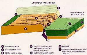
-aged Colter Formation. Beginning around 13 million years ago (also in the Miocene), a 40-mile (64-km) long steeply east dipping normal fault system called the Teton Fault
started to vertically move two adjacent blocks. One block, the Jackson Hole basin, moved down while the other block, containing the westward-tilting eastern part of the Teton Range, moved up; thus creating the youngest mountain range in the Rocky Mountains
. Most of the downward movement occurred right next to the fault, resuling in a 15° tilt of the Colter Formation. No sediment was deposited on top of the tilted Colter Formation for up to three million years, resulting in an angular unconformity as the tilted Colter partially eroded away.
Around 10 million years ago, Jackson Hole's first large freshwater lake
was impounded by east-west fault movement in what is today the southern end of the park. Geologists call this fault-scarp dammed body of shallow water Lake Teewinot and it persisted for around 5 million years. The resulting Teewinot Formation of lakebed sediments sits directly on the Colter and consists of limestone
s and claystone
s mixed with volcanic material and fossilized clam
s and snail
s. All told, sediments in the Tertiary
period attained an aggregate thickness of around 6 miles (10 km), forming the most complete non-marine Tertiary geologic column in the United States
. Most of these units within the park are, however, buried under younger deposits.
Eventually all the Mesozoic rock from the Teton Range was stripped away and the same formations in Jackson Hole were deeply buried. A prominent outcrop of the pink-colored Flathead Sandstone exits 6,000 feet (1,830 m) above the valley floor on the summit of Mount Moran. Drilling in Jackson Hole found the same formation 24,000 feet (7,300 m) below the valley's surface, indicating that the two blocks have been displaced 30,000 feet (9,100 m) from each other. Thus an average of one foot of movement occurred every 300 years (1 cm per year on average).
-forming eruption was preceded by a long period of more conventional eruptions along even earlier volcanic episodes. One such event sent large amounts of ryrolitic lava into the northern extent of Teewinot Lake. The resulting obsidian
(volcanic glass
) has been potassium-argon dated
to 9 million years and was used by Native Americans
starting thousands of years ago to make arrowhead
s, knives
, and spear
points. The lake was dry by the time a series of enormous pyroclastic flow
s from the Yellowstone area buried Jackson Hole under welded tuff
. Older exposures of this tuff are exposed in the Bivouac Formation at Signal Mountain
and Pleistocene-aged tuffs are found capping East and West Gros Venture Buttes (both the mountain and butte
s are small fault blocks
).
Climatic
conditions in the area gradually changed through the Cenozoic as continental drift
moved North America northwest from a sub-tropical to a temperate zone by the Pliocene epoch. The onset of a series of glaciations in the Pleistocene
epoch saw the introduction of large glacier
s in the Teton and surrounding ranges, which flowed all the way to Jackson Hole during at least three ice age
s. Cascade
, Garnet
, Death
and Granite Canyon
s were all carved by successive periods of glaciation.
The first and most severe of the known glacial advances in the area was caused by the Buffalo glaciation. In that event the individual alpine (mountain valley) glacier
s from the Tetons' east side coalesced to form a 2,000 foot (610 m) thick apron of ice that overrode and abraded Signal Mountain and the other three buttes at the south end of Jackson Hole. Similar dramas were repeated on other ranges in the region, eventually forming part of the Canadian Ice Sheet, which at its maximum, extended into eastern Idaho
. This continental-sized glacial system stripped all the soil
and vegetation
from countless valley
s and many basins, leaving them a wasteland of bedrock strewn with boulders after the glaciers finally retreated. Parts of Jackson Hole that were not touched by the following milder glaciations still cannot support anything but the hardiest plant
s (smaller glaciers deposit glacial till and small rocks relatively near their source, while continental glaciers transport all but the largest fragments far away).
A less severe glaciation, known as Bull Lake
, started sometime between 160 to 130 thousand years ago. Bull Lake helped repair some of the damage of the Buffalo event by forming smaller glaciers which deposited loose material over the bedrock. In that event, the large glacier which ran down Jackson Hole only extended just south of where Jackson, Wyoming
now sits and melted about 100,000 years ago.
 Then from 25,000 to 10,000 years ago the lower volume Wisconsin glaciation
carved many of the glacial features seen today. Burned Ridge is made of the terminal moraine
(rubble dump) of the largest of these glaciers to affect the area. Today this hummocky feature is covered with tree
s and other vegetation. Smaller moraines from a less severe part of the Pinedale were formed just below the base of each large valley in the Teton Range by alpine glaciers. Many of these piles of glacial rubble created depressions that in modern times are filled with a series of small lakes (Leigh
, String
, Jenny
, Bradley
, Taggart
, and Phelps
). Jackson Lake
is the largest of these and was impounded by a recessional moraine left by the last major glacier in Jackson Hole. A collection of kettles
(depressions left by melted stagnant ice blocks from a retreating glacier) south of the lake is called the Potholes. The basins that hold Two Ocean Lake
and Emma Matilda Lake
were created during the Bull Lake glaciation. Since then human
s have built a dam
over Jackson Lake's outlet to increase its size for recreation
al purposes.
All Pinedale glaciers probably melted away soon after the start of the Holocene
epoch. The dozen small cirque
glaciers seen today were formed during a subsequent neoglaciation
5000 years ago. Mount Moran has five such glaciers with Triple Glaciers
on the north face, Skillet Glacier
on the east face, and Falling Ice Glacier
on the southeast face. All the glacial action has made the peaks of the Teton Range jagged from frost wedging. Other glaciers include Teton Glacier
, below the east face of Grand Teton, Middle Teton Glacier
, situated on the northeast slopes of Middle Teton, and the fast retreating Schoolroom Glacier
, west of Grand Teton at Hurricane Pass.
Mass wasting
events such as the 1925 Gros Ventre landslide
continue to change the area. On June 22, 1925 an earthquake with an estimated magnitude of 4 weakened the side of a mountain located three miles (4.8 km) outside of the current park's southeastern border. The next day, 50 million cubic yards (38 million cubic meters) of water-saturated Pennsylvanian
-aged Tensleep Sandstone slid 1.5 miles (2.4 km) from its source on Sheep Mountain and into the Gros Ventre River
valley 2,100 feet (640 m) below, damming the river. Stressed by snow
melt, the resulting 5 mile (8 km) long and 200 feet (60 m) deep lake breached the debris dam on May 18, 1927 and flood
ed the town of Kelly, Wyoming
, killing six.
Rock (geology)
In geology, rock or stone is a naturally occurring solid aggregate of minerals and/or mineraloids.The Earth's outer solid layer, the lithosphere, is made of rock. In general rocks are of three types, namely, igneous, sedimentary, and metamorphic...
s and one of the youngest mountain range
Mountain range
A mountain range is a single, large mass consisting of a succession of mountains or narrowly spaced mountain ridges, with or without peaks, closely related in position, direction, formation, and age; a component part of a mountain system or of a mountain chain...
s in North America
North America
North America is a continent wholly within the Northern Hemisphere and almost wholly within the Western Hemisphere. It is also considered a northern subcontinent of the Americas...
. The Teton Range
Teton Range
The Teton Range is a mountain range of the Rocky Mountains in North America. A north-south range, it is on the Wyoming side of the state's border with Idaho, just south of Yellowstone National Park. Most of the range is in Grand Teton National Park....
, mostly located in Grand Teton National Park
Grand Teton National Park
Grand Teton National Park is a United States National Park located in northwestern Wyoming, U.S. The Park consists of approximately and includes the major peaks of the long Teton Range as well as most of the northern sections of the valley known as Jackson Hole. Only south of Yellowstone...
, started to grow some 9 million years ago. An older feature, Jackson Hole
Jackson Hole
Jackson Hole, originally called Jackson's Hole, is a valley located in the U.S. state of Wyoming, near the western border with Idaho. The name "hole" derives from language used by early trappers or mountain men, who primarily entered the valley from the north and east and had to descend along...
, is a basin
Sedimentary basin
The term sedimentary basin is used to refer to any geographical feature exhibiting subsidence and consequent infilling by sedimentation. As the sediments are buried, they are subjected to increasing pressure and begin the process of lithification...
that sits aside the range.
The 2,500 million year old metamorphic rock
Metamorphic rock
Metamorphic rock is the transformation of an existing rock type, the protolith, in a process called metamorphism, which means "change in form". The protolith is subjected to heat and pressure causing profound physical and/or chemical change...
s that make up the east face of the Tetons are marine in origin and include some volcanic
Volcano
2. Bedrock3. Conduit 4. Base5. Sill6. Dike7. Layers of ash emitted by the volcano8. Flank| 9. Layers of lava emitted by the volcano10. Throat11. Parasitic cone12. Lava flow13. Vent14. Crater15...
deposits. These same rocks are today buried deep inside Jackson Hole. Paleozoic
Paleozoic
The Paleozoic era is the earliest of three geologic eras of the Phanerozoic eon, spanning from roughly...
rocks were deposited in warm shallow sea
Sea
A sea generally refers to a large body of salt water, but the term is used in other contexts as well. Most commonly, it means a large expanse of saline water connected with an ocean, and is commonly used as a synonym for ocean...
s while Mesozoic
Mesozoic
The Mesozoic era is an interval of geological time from about 250 million years ago to about 65 million years ago. It is often referred to as the age of reptiles because reptiles, namely dinosaurs, were the dominant terrestrial and marine vertebrates of the time...
deposition transitioned back and forth from marine to non-marine sediments with the Cretaceous Seaway periodically covering the area late in that era.
70 million years ago, the Laramide orogeny
Laramide orogeny
The Laramide orogeny was a period of mountain building in western North America, which started in the Late Cretaceous, 70 to 80 million years ago, and ended 35 to 55 million years ago. The exact duration and ages of beginning and end of the orogeny are in dispute, as is the cause. The Laramide...
started to uplift western North America, erasing the seaway and creating highlands. The first part of the Teton Range was thus formed in the Eocene
Eocene
The Eocene Epoch, lasting from about 56 to 34 million years ago , is a major division of the geologic timescale and the second epoch of the Paleogene Period in the Cenozoic Era. The Eocene spans the time from the end of the Palaeocene Epoch to the beginning of the Oligocene Epoch. The start of the...
epoch. Large volcanic eruptions from in the Yellowstone-Absaroka
Absaroka Range
The Absaroka Range is a sub-range of the Rocky Mountains in the United States. The range stretches about 150 mi across the Montana-Wyoming border, forming the eastern boundary of Yellowstone National Park and the western side of the Bighorn Basin. The range borders the Beartooth Mountains...
area to the north left thick volcanic deposits. A series of glaciations in the Pleistocene
Pleistocene
The Pleistocene is the epoch from 2,588,000 to 11,700 years BP that spans the world's recent period of repeated glaciations. The name pleistocene is derived from the Greek and ....
epoch saw the introduction of large glacier
Glacier
A glacier is a large persistent body of ice that forms where the accumulation of snow exceeds its ablation over many years, often centuries. At least 0.1 km² in area and 50 m thick, but often much larger, a glacier slowly deforms and flows due to stresses induced by its weight...
s in the Teton and surrounding ranges, which at times formed part of the Canadian Ice Sheet. Moraine
Moraine
A moraine is any glacially formed accumulation of unconsolidated glacial debris which can occur in currently glaciated and formerly glaciated regions, such as those areas acted upon by a past glacial maximum. This debris may have been plucked off a valley floor as a glacier advanced or it may have...
s left by less severe ice age
Ice age
An ice age or, more precisely, glacial age, is a generic geological period of long-term reduction in the temperature of the Earth's surface and atmosphere, resulting in the presence or expansion of continental ice sheets, polar ice sheets and alpine glaciers...
s impounded several lakes, including Jackson Lake
Jackson Lake
Jackson Lake is a lake located in north western Wyoming in Grand Teton National Park. The lake is natural, except for the top 33 feet , which is due to the construction of Jackson Lake Dam, built in 1911. This top level of the lake is utilized by farmers in Idaho for irrigation purposes...
.
Precambrian deposition, metamorphism, and intrusion
Perhaps 3,000 million years ago in PrecambrianPrecambrian
The Precambrian is the name which describes the large span of time in Earth's history before the current Phanerozoic Eon, and is a Supereon divided into several eons of the geologic time scale...
time, sand
Sand
Sand is a naturally occurring granular material composed of finely divided rock and mineral particles.The composition of sand is highly variable, depending on the local rock sources and conditions, but the most common constituent of sand in inland continental settings and non-tropical coastal...
, lime
Lime (mineral)
Lime is a general term for calcium-containing inorganic materials, in which carbonates, oxides and hydroxides predominate. Strictly speaking, lime is calcium oxide or calcium hydroxide. It is also the name for a single mineral of the CaO composition, occurring very rarely...
y ooze, silt
Silt
Silt is granular material of a size somewhere between sand and clay whose mineral origin is quartz and feldspar. Silt may occur as a soil or as suspended sediment in a surface water body...
and clay
Clay
Clay is a general term including many combinations of one or more clay minerals with traces of metal oxides and organic matter. Geologic clay deposits are mostly composed of phyllosilicate minerals containing variable amounts of water trapped in the mineral structure.- Formation :Clay minerals...
were deposited in a marine trough (accurate dating is not possible, due to subsequent partial recrystallization of the resulting rock). Interbeded between these layers were volcanic
Volcano
2. Bedrock3. Conduit 4. Base5. Sill6. Dike7. Layers of ash emitted by the volcano8. Flank| 9. Layers of lava emitted by the volcano10. Throat11. Parasitic cone12. Lava flow13. Vent14. Crater15...
deposits, probably from an island arc
Island arc
An island arc is a type of archipelago composed of a chain of volcanoes which alignment is arc-shaped, and which are situated parallel and close to a boundary between two converging tectonic plates....
. These sediments were later lithified into sandstone
Sandstone
Sandstone is a sedimentary rock composed mainly of sand-sized minerals or rock grains.Most sandstone is composed of quartz and/or feldspar because these are the most common minerals in the Earth's crust. Like sand, sandstone may be any colour, but the most common colours are tan, brown, yellow,...
s, limestone
Limestone
Limestone is a sedimentary rock composed largely of the minerals calcite and aragonite, which are different crystal forms of calcium carbonate . Many limestones are composed from skeletal fragments of marine organisms such as coral or foraminifera....
s, and various shale
Shale
Shale is a fine-grained, clastic sedimentary rock composed of mud that is a mix of flakes of clay minerals and tiny fragments of other minerals, especially quartz and calcite. The ratio of clay to other minerals is variable. Shale is characterized by breaks along thin laminae or parallel layering...
s. These rocks were 5 to 10 miles (8 to 16 km) below the surface when orogenies
Orogeny
Orogeny refers to forces and events leading to a severe structural deformation of the Earth's crust due to the engagement of tectonic plates. Response to such engagement results in the formation of long tracts of highly deformed rock called orogens or orogenic belts...
(mountain
Mountain
Image:Himalaya_annotated.jpg|thumb|right|The Himalayan mountain range with Mount Everestrect 58 14 160 49 Chomo Lonzorect 200 28 335 52 Makalurect 378 24 566 45 Mount Everestrect 188 581 920 656 Tibetan Plateaurect 250 406 340 427 Rong River...
-building episodes) around 2,800 to 2,700 million years ago intensely folded and metamorphosed
Metamorphism
Metamorphism is the solid-state recrystallization of pre-existing rocks due to changes in physical and chemical conditions, primarily heat, pressure, and the introduction of chemically active fluids. Mineralogical, chemical and crystallographic changes can occur during this process...
them, creating alternating light and dark banded gneiss
Gneiss
Gneiss is a common and widely distributed type of rock formed by high-grade regional metamorphic processes from pre-existing formations that were originally either igneous or sedimentary rocks.-Etymology:...
and schist
Schist
The schists constitute a group of medium-grade metamorphic rocks, chiefly notable for the preponderance of lamellar minerals such as micas, chlorite, talc, hornblende, graphite, and others. Quartz often occurs in drawn-out grains to such an extent that a particular form called quartz schist is...
. Today these rocks dominate the Teton Range
Teton Range
The Teton Range is a mountain range of the Rocky Mountains in North America. A north-south range, it is on the Wyoming side of the state's border with Idaho, just south of Yellowstone National Park. Most of the range is in Grand Teton National Park....
with good examples easily viewable in Death Canyon and other canyons in the Teton Range. The green to black serpentine created was used by Native Americans
Native Americans in the United States
Native Americans in the United States are the indigenous peoples in North America within the boundaries of the present-day continental United States, parts of Alaska, and the island state of Hawaii. They are composed of numerous, distinct tribes, states, and ethnic groups, many of which survive as...
to make bowls.
Magma
Magma is a mixture of molten rock, volatiles and solids that is found beneath the surface of the Earth, and is expected to exist on other terrestrial planets. Besides molten rock, magma may also contain suspended crystals and dissolved gas and sometimes also gas bubbles. Magma often collects in...
intruded into the older rock, forming pluton
Intrusion
An intrusion is liquid rock that forms under Earth's surface. Magma from under the surface is slowly pushed up from deep within the earth into any cracks or spaces it can find, sometimes pushing existing country rock out of the way, a process that can take millions of years. As the rock slowly...
s of granitic
Granite
Granite is a common and widely occurring type of intrusive, felsic, igneous rock. Granite usually has a medium- to coarse-grained texture. Occasionally some individual crystals are larger than the groundmass, in which case the texture is known as porphyritic. A granitic rock with a porphyritic...
rock. Extensive exposures of this rock are found in the central part of the range. About 1,300 to 1,400 million years ago in Late Precambrian, 5 to 200 foot (1.5 to 60 m) thick black diabase
Diabase
Diabase or dolerite is a mafic, holocrystalline, subvolcanic rock equivalent to volcanic basalt or plutonic gabbro. In North American usage, the term diabase refers to the fresh rock, whilst elsewhere the term dolerite is used for the fresh rock and diabase refers to altered material...
dikes intruded as well, forming the prominent vertical dikes seen today on the faces of Mount Moran and Middle Teton (the dike on Mount Moran is 150 feet (45.7 m)). Some of the large dikes can be seen from the Jenny Lake and String Lake areas.
More than 700 million years elapsed between intrusion of the black dikes and deposition of the first Paleozic sedimentary rock
Sedimentary rock
Sedimentary rock are types of rock that are formed by the deposition of material at the Earth's surface and within bodies of water. Sedimentation is the collective name for processes that cause mineral and/or organic particles to settle and accumulate or minerals to precipitate from a solution....
s. The Precambrian rocks were uplifted during this gap in the geologic record known as an unconformity
Unconformity
An unconformity is a buried erosion surface separating two rock masses or strata of different ages, indicating that sediment deposition was not continuous. In general, the older layer was exposed to erosion for an interval of time before deposition of the younger, but the term is used to describe...
; exposed to erosion
Erosion
Erosion is when materials are removed from the surface and changed into something else. It only works by hydraulic actions and transport of solids in the natural environment, and leads to the deposition of these materials elsewhere...
they were gradually worn to a nearly featureless plain, perhaps somewhat resembling the vast flat areas in which similar Precambrian rocks are now exposed in central and eastern Canada
Canada
Canada is a North American country consisting of ten provinces and three territories. Located in the northern part of the continent, it extends from the Atlantic Ocean in the east to the Pacific Ocean in the west, and northward into the Arctic Ocean...
. At the close of Precambrian time, about 600 million years ago, the plain slowly subsided and the site of the future Teton Range disappeared beneath shallow seas that were to wash across it intermittently for the next 500 million years.
Paleozoic deposition
Deposition resumed in the CambrianCambrian
The Cambrian is the first geological period of the Paleozoic Era, lasting from Mya ; it is succeeded by the Ordovician. Its subdivisions, and indeed its base, are somewhat in flux. The period was established by Adam Sedgwick, who named it after Cambria, the Latin name for Wales, where Britain's...
period and continued through the Paleozoic
Paleozoic
The Paleozoic era is the earliest of three geologic eras of the Phanerozoic eon, spanning from roughly...
era, creating nine major formations which together are 4,000 feet (1,200 m) thick (the only geologic period in the Paleozoic not represented is the Silurian
Silurian
The Silurian is a geologic period and system that extends from the end of the Ordovician Period, about 443.7 ± 1.5 Mya , to the beginning of the Devonian Period, about 416.0 ± 2.8 Mya . As with other geologic periods, the rock beds that define the period's start and end are well identified, but the...
). This unit was laid down in a shallow sea
Sea
A sea generally refers to a large body of salt water, but the term is used in other contexts as well. Most commonly, it means a large expanse of saline water connected with an ocean, and is commonly used as a synonym for ocean...
and later became a discontinuous mix of dolomite
Dolomite
Dolomite is a carbonate mineral composed of calcium magnesium carbonate CaMg2. The term is also used to describe the sedimentary carbonate rock dolostone....
, limestone, sandstones, and shales. The layers of this unit are relatively undeformed for their age even though periodic upwarp exposed them to erosion
Erosion
Erosion is when materials are removed from the surface and changed into something else. It only works by hydraulic actions and transport of solids in the natural environment, and leads to the deposition of these materials elsewhere...
, creating uncomformities . Fossilized brachiopod
Brachiopod
Brachiopods are a phylum of marine animals that have hard "valves" on the upper and lower surfaces, unlike the left and right arrangement in bivalve molluscs. Brachiopod valves are hinged at the rear end, while the front can be opened for feeding or closed for protection...
s, bryozoans, coral
Coral
Corals are marine animals in class Anthozoa of phylum Cnidaria typically living in compact colonies of many identical individual "polyps". The group includes the important reef builders that inhabit tropical oceans and secrete calcium carbonate to form a hard skeleton.A coral "head" is a colony of...
s, and trilobite
Trilobite
Trilobites are a well-known fossil group of extinct marine arthropods that form the class Trilobita. The first appearance of trilobites in the fossil record defines the base of the Atdabanian stage of the Early Cambrian period , and they flourished throughout the lower Paleozoic era before...
s are found in the carbonate rock
Carbonate rock
Carbonate rocks are a class of sedimentary rocks composed primarily of carbonate minerals. The two major types are limestone, which is composed of calcite or aragonite and dolostone, which is composed of the mineral dolomite .Calcite can be either dissolved by groundwater or precipitated by...
layers with the best examples found outside the park in the Alaska Basin. The most complete examples of this unit are found to the west, north, and south of park borders.
On the edge of a shallow seaway
Cambrian
The Cambrian is the first geological period of the Paleozoic Era, lasting from Mya ; it is succeeded by the Ordovician. Its subdivisions, and indeed its base, are somewhat in flux. The period was established by Adam Sedgwick, who named it after Cambria, the Latin name for Wales, where Britain's...
time a shallow seaway, called the Cordilleran trough, extended from southern California
California
California is a state located on the West Coast of the United States. It is by far the most populous U.S. state, and the third-largest by land area...
northeastward across Nevada
Nevada
Nevada is a state in the western, mountain west, and southwestern regions of the United States. With an area of and a population of about 2.7 million, it is the 7th-largest and 35th-most populous state. Over two-thirds of Nevada's people live in the Las Vegas metropolitan area, which contains its...
into Utah
Utah
Utah is a state in the Western United States. It was the 45th state to join the Union, on January 4, 1896. Approximately 80% of Utah's 2,763,885 people live along the Wasatch Front, centering on Salt Lake City. This leaves vast expanses of the state nearly uninhabited, making the population the...
and Idaho
Idaho
Idaho is a state in the Rocky Mountain area of the United States. The state's largest city and capital is Boise. Residents are called "Idahoans". Idaho was admitted to the Union on July 3, 1890, as the 43rd state....
. The vast gently rolling plain on Precambrian rocks to the east was drained by sluggish westward-flowing river
River
A river is a natural watercourse, usually freshwater, flowing towards an ocean, a lake, a sea, or another river. In a few cases, a river simply flows into the ground or dries up completely before reaching another body of water. Small rivers may also be called by several other names, including...
s that carried sand and mud into the sea. The site of the Teton Range was part of this plain. Slow subsidence of the land caused the sea to spread gradually eastward during Middle Cambrian time flooding the Precambrian plain. Sand accumulated along the beaches just as it does today. As the sea moved still farther east, mud was deposited on the now-submerged beach sand. In the Teton area, the oldest sand deposit is the 175 to 200 feet (53 to 60 m) thick Flathead Sandstone. The partly marine Flathead Sandstone is reddish-brown, very hard, brittle and exposures can be found on the north and west flanks of the Teton Range
Teton Range
The Teton Range is a mountain range of the Rocky Mountains in North America. A north-south range, it is on the Wyoming side of the state's border with Idaho, just south of Yellowstone National Park. Most of the range is in Grand Teton National Park....
and Gros Ventre Mountains.
Mud was laid down on top of the Flathead Sandstone as the shoreline advanced eastward across the Teton area. The resulting soft greenish-gray shale
Shale
Shale is a fine-grained, clastic sedimentary rock composed of mud that is a mix of flakes of clay minerals and tiny fragments of other minerals, especially quartz and calcite. The ratio of clay to other minerals is variable. Shale is characterized by breaks along thin laminae or parallel layering...
with beds of purple and green sandstone near its base, became the 100 feet (30 m) thick Wolsey Shale Member of the Gros Ventre Formation. Some shale shows patterns of cracks that formed when the accumulating mud was briefly exposed to the air along tidal flats. Small phosphatic-shelled animals called brachiopod
Brachiopod
Brachiopods are a phylum of marine animals that have hard "valves" on the upper and lower surfaces, unlike the left and right arrangement in bivalve molluscs. Brachiopod valves are hinged at the rear end, while the front can be opened for feeding or closed for protection...
s inhabited these tidal flats but as far as is known, nothing lived on land. Many shale beds are marked with faint trails and borings of worm
Worm
The term worm refers to an obsolete taxon used by Carolus Linnaeus and Jean-Baptiste Lamarck for all non-arthropod invertebrate animals, and stems from the Old English word wyrm. Currently it is used to describe many different distantly-related animals that typically have a long cylindrical...
like creatures, and a few contain the remains of tiny trilobite
Trilobite
Trilobites are a well-known fossil group of extinct marine arthropods that form the class Trilobita. The first appearance of trilobites in the fossil record defines the base of the Atdabanian stage of the Early Cambrian period , and they flourished throughout the lower Paleozoic era before...
s.
Covered by a shallow sea
Conglomerate (geology)
A conglomerate is a rock consisting of individual clasts within a finer-grained matrix that have become cemented together. Conglomerates are sedimentary rocks consisting of rounded fragments and are thus differentiated from breccias, which consist of angular clasts...
along with fossils of trilobites and brachiopods. Underwater expanses of algae
Algae
Algae are a large and diverse group of simple, typically autotrophic organisms, ranging from unicellular to multicellular forms, such as the giant kelps that grow to 65 meters in length. They are photosynthetic like plants, and "simple" because their tissues are not organized into the many...
flourished in places on the sea bottom and built extensive reef
Reef
In nautical terminology, a reef is a rock, sandbar, or other feature lying beneath the surface of the water ....
s. Periodically shoal areas were hit by violent storm
Storm
A storm is any disturbed state of an astronomical body's atmosphere, especially affecting its surface, and strongly implying severe weather...
waves that tore loose platy fragments of recently solidified limestone and swept them into nearby channels where they were buried and cemented into thin beds of jumbled fragments called 'edgewise' conglomerate. These are wide spread in the shale and in overlying and underlying limestones.
By Late Cambrian, the shoreline had once again crept eastward, resulting in clearer water that was probably 100 to 200 feet (30 to 60 m) deep. The 100 foot (30 m) thick Gallatin Limestone was formed. It consists of blue-gray limestone that is mottled with irregular rusty or yellow patches. Interrupting the limestone are a few beds of 'edgewise' conglomerate that are indicative of sporadic storms. Now at its maximum extent, the sea covered all of Idaho
Idaho
Idaho is a state in the Rocky Mountain area of the United States. The state's largest city and capital is Boise. Residents are called "Idahoans". Idaho was admitted to the Union on July 3, 1890, as the 43rd state....
, Montana
Montana
Montana is a state in the Western United States. The western third of Montana contains numerous mountain ranges. Smaller, "island ranges" are found in the central third of the state, for a total of 77 named ranges of the Rocky Mountains. This geographical fact is reflected in the state's name,...
, most of Wyoming
Wyoming
Wyoming is a state in the mountain region of the Western United States. The western two thirds of the state is covered mostly with the mountain ranges and rangelands in the foothills of the Eastern Rocky Mountains, while the eastern third of the state is high elevation prairie known as the High...
and extended eastward across the Dakotas to connect with shallow seas that covered the eastern United States
United States
The United States of America is a federal constitutional republic comprising fifty states and a federal district...
. Soon after, a slow uplift caused the sea to gradually retreat westward. The site of the Teton Range emerged above sea level
Sea level
Mean sea level is a measure of the average height of the ocean's surface ; used as a standard in reckoning land elevation...
, where, as far as is known, it may have been exposed to erosion for nearly 70 million years.
Uplift puts the area back on the sea's edge
Calcium carbonate
Calcium carbonate is a chemical compound with the formula CaCO3. It is a common substance found in rocks in all parts of the world, and is the main component of shells of marine organisms, snails, coal balls, pearls, and eggshells. Calcium carbonate is the active ingredient in agricultural lime,...
mud that was altered by magnesium-rich sea water shortly after deposition. Corals and other marine animals were abundant in the clear warm seas at this time.
Dolomite in the Darby Formation of Devonian age differs greatly from the Bighorn Dolomite; that in the Darby is dark-brown to almost black, has an oily smell, and contains layers of black, pink, and yellow mudstone and thin sandstone. The sea bottom during deposition of these rocks was foul and frequently the water was turbid. Abundant fossil fragments indicate fishes were common for the first time. Exposures of the Darby Formation are recognizable by their distinctive dull-yellow thin-layered slopes between the prominent gray massive cliffs of formations below and above.
The Madison Limestone of Mississippian age is 1000 feet (304.8 m) thick and is exposed in spectacular vertical cliffs along canyons in the north, west, and south parts of the Tetons. It is noted for the abundant remains of beautifully preserved marine organisms. The fossils and the relatively pure blue-gray limestone in which they are embedded indicate deposition in warm tranquil seas. The Fossil Mountain Ice Cave—Wind Cave system on the west side of the Teton range was dissolved out of this rock by water.
The Pennsylvanian System is represented by the Amsden Formation and the Tensleep Sandstone. Cliffs of the Tensleep Sandstone can be seen along the Gros Ventre River at the east edge of the park. The Amsden, below the Tensleep, consists of red and green shale, sandstone, and thin limestone. The shale is especially weak and slippery when exposed to weathering and saturated with water. These are the strata that make up the glide plane of the Lower Gros Ventre Slide east of the park.
The Phosphoria Formation and its equivalents of Permian age are unlike any other Paleozoic rocks because of their extraordinary content of uncommon elements. The formation consists of sandy dolomite, widespread black phosphate beds and black shale that is unusually rich not only in phosphorus, but also in vanadium, uranium, chromium, zinc, selenium, molybdenum, cobalt, and silver. The formation is mined extensively in nearby parts of Idaho and in Wyoming for phosphatic fertilizer, for the chemical element phosphorus, and for some of the metals that can be derived from the rocks as by-products. These elements and compounds are not everywhere concentrated enough to be of economic interest, but their dollar-value is, in a regional sense, comparaible to that of some of the world's greatest mineral deposits.
Mesozoic deposition
Mesozoic
The Mesozoic era is an interval of geological time from about 250 million years ago to about 65 million years ago. It is often referred to as the age of reptiles because reptiles, namely dinosaurs, were the dominant terrestrial and marine vertebrates of the time...
deposition changed from primarily marine to a mix of marine, transitional, and continent
Continent
A continent is one of several very large landmasses on Earth. They are generally identified by convention rather than any strict criteria, with seven regions commonly regarded as continents—they are : Asia, Africa, North America, South America, Antarctica, Europe, and Australia.Plate tectonics is...
al that varied over time as crustal conditions altered the region. By the close of this era, 10,000 to 15,000 feet (3,000 to 4,500 m) of sediment accumulated in 15 recognized formations. The most extensive non-marine formations were deposited in the Cretaceous
Cretaceous
The Cretaceous , derived from the Latin "creta" , usually abbreviated K for its German translation Kreide , is a geologic period and system from circa to million years ago. In the geologic timescale, the Cretaceous follows the Jurassic period and is followed by the Paleogene period of the...
period when the eastern part of the Cretaceous Seaway (a warm shallow sea
Sea
A sea generally refers to a large body of salt water, but the term is used in other contexts as well. Most commonly, it means a large expanse of saline water connected with an ocean, and is commonly used as a synonym for ocean...
that periodically divided North America
North America
North America is a continent wholly within the Northern Hemisphere and almost wholly within the Western Hemisphere. It is also considered a northern subcontinent of the Americas...
in that period) covered the region. Their sediment came from rock
Rock (geology)
In geology, rock or stone is a naturally occurring solid aggregate of minerals and/or mineraloids.The Earth's outer solid layer, the lithosphere, is made of rock. In general rocks are of three types, namely, igneous, sedimentary, and metamorphic...
eroded from a mountain
Mountain
Image:Himalaya_annotated.jpg|thumb|right|The Himalayan mountain range with Mount Everestrect 58 14 160 49 Chomo Lonzorect 200 28 335 52 Makalurect 378 24 566 45 Mount Everestrect 188 581 920 656 Tibetan Plateaurect 250 406 340 427 Rong River...
chain east of the seaway interbeded with ash
Volcanic ash
Volcanic ash consists of small tephra, which are bits of pulverized rock and glass created by volcanic eruptions, less than in diameter. There are three mechanisms of volcanic ash formation: gas release under decompression causing magmatic eruptions; thermal contraction from chilling on contact...
from volcano
Volcano
2. Bedrock3. Conduit 4. Base5. Sill6. Dike7. Layers of ash emitted by the volcano8. Flank| 9. Layers of lava emitted by the volcano10. Throat11. Parasitic cone12. Lava flow13. Vent14. Crater15...
s west of the seaway in the Sierran Arc
Sierran Arc
In early Triassic time, an extensive volcanic arc system, called the Sierran Arc began to develop along the western margin of the North American continent...
(a long volcanic island chain like the modern Andes Mountains but in island form). This ash eventually became bentonite
Bentonite
Bentonite is an absorbent aluminium phyllosilicate, essentially impure clay consisting mostly of montmorillonite. There are different types of bentonite, each named after the respective dominant element, such as potassium , sodium , calcium , and aluminum . Experts debate a number of nomenclatorial...
, a clay
Clay
Clay is a general term including many combinations of one or more clay minerals with traces of metal oxides and organic matter. Geologic clay deposits are mostly composed of phyllosilicate minerals containing variable amounts of water trapped in the mineral structure.- Formation :Clay minerals...
which expands in water
Water
Water is a chemical substance with the chemical formula H2O. A water molecule contains one oxygen and two hydrogen atoms connected by covalent bonds. Water is a liquid at ambient conditions, but it often co-exists on Earth with its solid state, ice, and gaseous state . Water also exists in a...
and thus causes landslide
Landslide
A landslide or landslip is a geological phenomenon which includes a wide range of ground movement, such as rockfalls, deep failure of slopes and shallow debris flows, which can occur in offshore, coastal and onshore environments...
s in the park.
Regional uplift in latest Cretaceous time caused the seaway to retreat and transformed the Grand Teton area into a low-lying coastal plain that was frequented by dinosaur
Dinosaur
Dinosaurs are a diverse group of animals of the clade and superorder Dinosauria. They were the dominant terrestrial vertebrates for over 160 million years, from the late Triassic period until the end of the Cretaceous , when the Cretaceous–Paleogene extinction event led to the extinction of...
s (a fossilized Triceratops
Triceratops
Triceratops is a genus of herbivorous ceratopsid dinosaur which lived during the late Maastrichtian stage of the Late Cretaceous Period, around 68 to 65 million years ago in what is now North America. It was one of the last dinosaur genera to appear before the great Cretaceous–Paleogene...
was found east of the park near Togwotee Pass). Coal
Coal
Coal is a combustible black or brownish-black sedimentary rock usually occurring in rock strata in layers or veins called coal beds or coal seams. The harder forms, such as anthracite coal, can be regarded as metamorphic rock because of later exposure to elevated temperature and pressure...
beds were eventually created from the swamp
Swamp
A swamp is a wetland with some flooding of large areas of land by shallow bodies of water. A swamp generally has a large number of hammocks, or dry-land protrusions, covered by aquatic vegetation, or vegetation that tolerates periodical inundation. The two main types of swamp are "true" or swamp...
s and bog
Bog
A bog, quagmire or mire is a wetland that accumulates acidic peat, a deposit of dead plant material—often mosses or, in Arctic climates, lichens....
s left behind after the last stand of the seaway retreated. Coal outcrops can be found near abandoned mine
Mining
Mining is the extraction of valuable minerals or other geological materials from the earth, from an ore body, vein or seam. The term also includes the removal of soil. Materials recovered by mining include base metals, precious metals, iron, uranium, coal, diamonds, limestone, oil shale, rock...
s in and outside of the eastern margin of the park. Outcrops of older Mesozoic-aged formations can be found north, east, and south of the park.
Sundance Sea covers older deposits
Most of the basal part of the Mesozoic sequence consists of the more than 1000 feet (304.8 m) thick, soft, bright-red, and Triassic-aged rocks known as the Chugwater FormationChugwater formation
The Chugwater Formation is a mapped bedrock unit consisting primarily of red sandstone, in the states of Wyoming, Montana, and Colorado in the USA...
. The distribution of Mud cracks, fossilized reptiles and amphibians suggest deposition in a tidal flat environment with a sea several kilometers southwest of Jackson Hole. Evaporite deposits of a few beds of white gypsum
Gypsum
Gypsum is a very soft sulfate mineral composed of calcium sulfate dihydrate, with the chemical formula CaSO4·2H2O. It is found in alabaster, a decorative stone used in Ancient Egypt. It is the second softest mineral on the Mohs Hardness Scale...
(calcium sulfate
Calcium sulfate
Calcium sulfate is a common laboratory and industrial chemical. In the form of γ-anhydrite , it is used as a desiccant. It is also used as a coagulant in products like tofu. In the natural state, unrefined calcium sulfate is a translucent, crystalline white rock...
) were likely formed after shallow bodies of salt water were cut off from the sea. A small amount of iron oxide
Iron oxide
Iron oxides are chemical compounds composed of iron and oxygen. All together, there are sixteen known iron oxides and oxyhydroxides.Iron oxides and oxide-hydroxides are widespread in nature, play an important role in many geological and biological processes, and are widely utilized by humans, e.g.,...
creates the red color and the formation erodes into colorful hills east and south of the park.
As the Triassic gave way to the Jurassic, wind spread salmon-red colored sand across the red beds of the Chugwater Formation to form the Nugget Sandstone. The Nugget in turn was buried by the deposits of thin red shale
Shale
Shale is a fine-grained, clastic sedimentary rock composed of mud that is a mix of flakes of clay minerals and tiny fragments of other minerals, especially quartz and calcite. The ratio of clay to other minerals is variable. Shale is characterized by breaks along thin laminae or parallel layering...
and thick gypsum of the Gypsum Springs Formation
Gypsum Springs Formation
The Gypsum Springs Formation is a stratigraphical unit of Middle Jurassic age in the Williston Basin.It takes the name from Gypsum Springs in Wyoming, and was first described in outcrop in Freemont County by J.D...
. Later, a warm, muddy, shallow sea with abundant marine mollusks called the Sundance Sea
Sundance Sea
The Sundance Sea was an epeiric sea that existed in North America during the mid to late Jurassic Period of the Mesozoic Era. It was an arm of what is now the Arctic Ocean, and extended through what is now western Canada into the central western United States...
started to spread from Alaska
Alaska
Alaska is the largest state in the United States by area. It is situated in the northwest extremity of the North American continent, with Canada to the east, the Arctic Ocean to the north, and the Pacific Ocean to the west and south, with Russia further west across the Bering Strait...
south to Wyoming
Wyoming
Wyoming is a state in the mountain region of the Western United States. The western two thirds of the state is covered mostly with the mountain ranges and rangelands in the foothills of the Eastern Rocky Mountains, while the eastern third of the state is high elevation prairie known as the High...
. More than 500 feet (152.4 m) of soft gray fossil-rich shale
Shale
Shale is a fine-grained, clastic sedimentary rock composed of mud that is a mix of flakes of clay minerals and tiny fragments of other minerals, especially quartz and calcite. The ratio of clay to other minerals is variable. Shale is characterized by breaks along thin laminae or parallel layering...
and thin beds of limestone
Limestone
Limestone is a sedimentary rock composed largely of the minerals calcite and aragonite, which are different crystal forms of calcium carbonate . Many limestones are composed from skeletal fragments of marine organisms such as coral or foraminifera....
and sandstone
Sandstone
Sandstone is a sedimentary rock composed mainly of sand-sized minerals or rock grains.Most sandstone is composed of quartz and/or feldspar because these are the most common minerals in the Earth's crust. Like sand, sandstone may be any colour, but the most common colours are tan, brown, yellow,...
s were deposited. After the sea withdrew, the Jurassic and Lower Cretaceous-aged Morrison
Morrison Formation
The Morrison Formation is a distinctive sequence of Late Jurassic sedimentary rock that is found in the western United States, which has been the most fertile source of dinosaur fossils in North America. It is composed of mudstone, sandstone, siltstone and limestone and is light grey, greenish...
and Cloverly Formation
Cloverly Formation
The Cloverly Formation are Lower Cretaceous strata located in Montana and Wyoming, in the western United States. The term now includes strata that had formerly been called the Dakota Formation in central and southern Wyoming.-Members:...
s were laid down on low-lying tropically humid flood plains. These formations erode into colorful badlands of red, pink, purple, and green claystones and mudstones, and yellow to buff sandstones. Large and small dinosaur
Dinosaur
Dinosaurs are a diverse group of animals of the clade and superorder Dinosauria. They were the dominant terrestrial vertebrates for over 160 million years, from the late Triassic period until the end of the Cretaceous , when the Cretaceous–Paleogene extinction event led to the extinction of...
s roamed the abundant vegetation and swamp
Swamp
A swamp is a wetland with some flooding of large areas of land by shallow bodies of water. A swamp generally has a large number of hammocks, or dry-land protrusions, covered by aquatic vegetation, or vegetation that tolerates periodical inundation. The two main types of swamp are "true" or swamp...
s.
Western Interior Seaway expands and retracts
Brightly colored rocks continued to be deposited as the final period of the Mesozoic, the CretaceousCretaceous
The Cretaceous , derived from the Latin "creta" , usually abbreviated K for its German translation Kreide , is a geologic period and system from circa to million years ago. In the geologic timescale, the Cretaceous follows the Jurassic period and is followed by the Paleogene period of the...
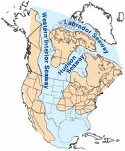
dawned. Another warm, shallow sea, the Western Interior Seaway
Western Interior Seaway
The Western Interior Seaway, also called the Cretaceous Seaway, the Niobraran Sea, and the North American Inland Sea, was a huge inland sea that split the continent of North America into two halves, Laramidia and Appalachia, during most of the mid- and late-Cretaceous Period...
, then partly and sometimes completely covered the Teton region along with most of Wyoming, About 10000 feet (3,048 m) of drab-colored sand, silt, and clay with some coal beds, volcanic ash layers, and minor amounts of gravel were deposited.
The Western Interior Seaway retreated eastward from the Teton region around 85 million years ago, marked by deposition of the Bacon Ridge Sandstone. Extensive coal swamps formed along and followed the retreating seashore, leaving coal beds 5 to 10 feet (3 m) thick in the Upper Cretaceous strata. Examples of these coal beds are visible in abandoned mines found in the eastern margin of the park. A modern analog of this depositional environment
Sedimentary depositional environment
In geology, sedimentary depositional environment describes the combination of physical, chemical and biological processes associated with the deposition of a particular type of sediment and, therefore, the rock types that will be formed after lithification, if the sediment is preserved in the rock...
is the hot and humid climate of the Florida Everglades. About 5 feet (1.5 m) of compacted plant material is needed to form 1 inches (25.4 mm) of coal.
Fine-grained volcanic ash
Volcanic ash
Volcanic ash consists of small tephra, which are bits of pulverized rock and glass created by volcanic eruptions, less than in diameter. There are three mechanisms of volcanic ash formation: gas release under decompression causing magmatic eruptions; thermal contraction from chilling on contact...
from volcano
Volcano
2. Bedrock3. Conduit 4. Base5. Sill6. Dike7. Layers of ash emitted by the volcano8. Flank| 9. Layers of lava emitted by the volcano10. Throat11. Parasitic cone12. Lava flow13. Vent14. Crater15...
es west and northwest of the Teton area was periodically deposited in in the quiet shallow water of the Western Interior Seaway throughout Cretaceous time. Ash deposited in this manor was later altered to bentonite
Bentonite
Bentonite is an absorbent aluminium phyllosilicate, essentially impure clay consisting mostly of montmorillonite. There are different types of bentonite, each named after the respective dominant element, such as potassium , sodium , calcium , and aluminum . Experts debate a number of nomenclatorial...
; a type of clay used in the foundry industry and as a component of oil well
Oil well
An oil well is a general term for any boring through the earth's surface that is designed to find and acquire petroleum oil hydrocarbons. Usually some natural gas is produced along with the oil. A well that is designed to produce mainly or only gas may be termed a gas well.-History:The earliest...
drilling mud. Elk
Elk
The Elk is the large deer, also called Cervus canadensis or wapiti, of North America and eastern Asia.Elk may also refer to:Other antlered mammals:...
and deer in Jackson Hole use exposures of bentonite as a (bitter) salt lick
Salt lick
A mineral lick is a natural mineral deposit where animals in nutrient-poor ecosystems can obtain essential mineral nutrients...
. Bentonite swells when wet, which causes landslides that sometimes block access roads into Jackson Hole.
Cretaceous-aged rocks in the Teton region form part of a huge east-thinning wedge of crust that is locally almost 2 miles (3.2 km) thick. Most of these rocks are from debris eroded from slowly rising mountains in the west. Bentonite, crude oil and natural gas
Natural gas
Natural gas is a naturally occurring gas mixture consisting primarily of methane, typically with 0–20% higher hydrocarbons . It is found associated with other hydrocarbon fuel, in coal beds, as methane clathrates, and is an important fuel source and a major feedstock for fertilizers.Most natural...
are commonly produced from the various Cretaceous formations. Enormous coal reserves, with some beds reaching 50 to 100 feet (30.5 m) thick, are a potential vast resrouce.
By the end of the Cretaceous, slightly more than 80 million years ago, the region's landscape was flat and monotonous; a condition that persisted during most of the Late Cretaceous.
Rocky Mountains rise
The period of uplift that resulted in the formation of the ancestral Rocky MountainsRocky Mountains
The Rocky Mountains are a major mountain range in western North America. The Rocky Mountains stretch more than from the northernmost part of British Columbia, in western Canada, to New Mexico, in the southwestern United States...
is called the Laramide orogeny
Laramide orogeny
The Laramide orogeny was a period of mountain building in western North America, which started in the Late Cretaceous, 70 to 80 million years ago, and ended 35 to 55 million years ago. The exact duration and ages of beginning and end of the orogeny are in dispute, as is the cause. The Laramide...
. Mountains already existed west and southwest of Wyoming, with progressively older mountains (up to Jurassic age) trending west into Nevada. Latest Cretaceous time saw the formation of a low broad northwest-trending arch along the approximate area of the present Teton Range and Gros Ventre Mountains.
Part of the evidence for the first Laramide mountain building west of the Teton region is the several hundred cubic miles of quartzite
Quartzite
Quartzite is a hard metamorphic rock which was originally sandstone. Sandstone is converted into quartzite through heating and pressure usually related to tectonic compression within orogenic belts. Pure quartzite is usually white to gray, though quartzites often occur in various shades of pink...
boulders derived from the Targhee uplift, which was located north and west of the northern end of the present-day Teton Range. Streams carried boulders, sand, and clay from the uplift eastward and southeastward across what would become Jackson Hole. Flakes of gold
Gold
Gold is a chemical element with the symbol Au and an atomic number of 79. Gold is a dense, soft, shiny, malleable and ductile metal. Pure gold has a bright yellow color and luster traditionally considered attractive, which it maintains without oxidizing in air or water. Chemically, gold is a...
and some mercury
Mercury (element)
Mercury is a chemical element with the symbol Hg and atomic number 80. It is also known as quicksilver or hydrargyrum...
are in the resulting Harebell Formation
Harebell Formation
The Harebell Formation is a Mesozoic geologic formation. Dinosaur remains diagnostic to the genus level are among the fossils that have been recovered from the formation.-See also:* List of dinosaur-bearing rock formations...
. Two huge depositional troughs were formed in central and southern Wyoming from fine-grained debris carried farther east and southeast. Many of the larger boulders were derived from Precambrian and possibly lower Paleozoic quartzites, meaning that at least 15000 feet (4,572 m) of Paleozoic and Mesozoic rock must have been stripped from the Targhee uplift before the quartzites were exposed to erosion.
Tertiary uplift and deposition
The tectonic settingPlate tectonics
Plate tectonics is a scientific theory that describes the large scale motions of Earth's lithosphere...
of western North America changed drastically as the Farallon Plate
Farallon Plate
The Farallon Plate was an ancient oceanic plate, which began subducting under the west coast of the North American Plate— then located in modern Utah— as Pangaea broke apart during the Jurassic Period...
under the Pacific Ocean
Pacific Ocean
The Pacific Ocean is the largest of the Earth's oceanic divisions. It extends from the Arctic in the north to the Southern Ocean in the south, bounded by Asia and Australia in the west, and the Americas in the east.At 165.2 million square kilometres in area, this largest division of the World...
to the west was shallowly subducted
Subduction
In geology, subduction is the process that takes place at convergent boundaries by which one tectonic plate moves under another tectonic plate, sinking into the Earth's mantle, as the plates converge. These 3D regions of mantle downwellings are known as "Subduction Zones"...
below North American Plate
North American Plate
The North American Plate is a tectonic plate covering most of North America, Greenland, Cuba, Bahamas, and parts of Siberia, Japan and Iceland. It extends eastward to the Mid-Atlantic Ridge and westward to the Chersky Range in eastern Siberia. The plate includes both continental and oceanic crust...
. Called the Laramide orogeny
Laramide orogeny
The Laramide orogeny was a period of mountain building in western North America, which started in the Late Cretaceous, 70 to 80 million years ago, and ended 35 to 55 million years ago. The exact duration and ages of beginning and end of the orogeny are in dispute, as is the cause. The Laramide...
, the compressive forces generated from this collision erased the Cretaceous Seaway, fused the Sierran Arc to the rest of North America and created the Rocky Mountains
Rocky Mountains
The Rocky Mountains are a major mountain range in western North America. The Rocky Mountains stretch more than from the northernmost part of British Columbia, in western Canada, to New Mexico, in the southwestern United States...
. This mountain-building event started in the Mesozoic 80 million years ago and lasted well into the first half of the Cenozoic
Cenozoic
The Cenozoic era is the current and most recent of the three Phanerozoic geological eras and covers the period from 65.5 mya to the present. The era began in the wake of the Cretaceous–Tertiary extinction event at the end of the Cretaceous that saw the demise of the last non-avian dinosaurs and...
era 30 million years ago.
Thrust fault
A thrust fault is a type of fault, or break in the Earth's crust across which there has been relative movement, in which rocks of lower stratigraphic position are pushed up and over higher strata. They are often recognized because they place older rocks above younger...
s of the nearby Wyoming Overthrust Belt. Uplift intensified and climaxed a few million years later early in the Eocene
Eocene
The Eocene Epoch, lasting from about 56 to 34 million years ago , is a major division of the geologic timescale and the second epoch of the Paleogene Period in the Cenozoic Era. The Eocene spans the time from the end of the Palaeocene Epoch to the beginning of the Oligocene Epoch. The start of the...
epoch when large thrust and reverse faults
Geologic fault
In geology, a fault is a planar fracture or discontinuity in a volume of rock, across which there has been significant displacement along the fractures as a result of earth movement. Large faults within the Earth's crust result from the action of tectonic forces...
created small mountain range
Mountain range
A mountain range is a single, large mass consisting of a succession of mountains or narrowly spaced mountain ridges, with or without peaks, closely related in position, direction, formation, and age; a component part of a mountain system or of a mountain chain...
s separated by subsiding sedimentary basins. One of the reverse faults, the north-south trending 10 mile (16 km) long Buck Mountain Fault, elevated what is today the central part of the Teton Range
Teton Range
The Teton Range is a mountain range of the Rocky Mountains in North America. A north-south range, it is on the Wyoming side of the state's border with Idaho, just south of Yellowstone National Park. Most of the range is in Grand Teton National Park....
.
By about 34 million years ago, these forces had uplifted a broad part of western Wyoming
Wyoming
Wyoming is a state in the mountain region of the Western United States. The western two thirds of the state is covered mostly with the mountain ranges and rangelands in the foothills of the Eastern Rocky Mountains, while the eastern third of the state is high elevation prairie known as the High...
into a continuous high plateau
Plateau
In geology and earth science, a plateau , also called a high plain or tableland, is an area of highland, usually consisting of relatively flat terrain. A highly eroded plateau is called a dissected plateau...
. This region includes areas now occupied by the Teton Range, Gros Venture Range, Wind River Mountains and other mountain ranges to the south and east of the Tetons. A separate area of uplift called the Targhee Uplift formed north of park borders around this time.
Subsequent erosion
Erosion
Erosion is when materials are removed from the surface and changed into something else. It only works by hydraulic actions and transport of solids in the natural environment, and leads to the deposition of these materials elsewhere...
of the Targhee Uplift was driven by steepened stream gradient
Stream gradient
Stream gradient is the grade measured by the ratio of drop in a stream per unit distance, usually expressed as feet per mile or metres per kilometre.-Hydrology and geology:A high gradient indicates a steep slope and rapid flow of water Stream gradient is the grade (slope) measured by the ratio of...
s. Gravel
Gravel
Gravel is composed of unconsolidated rock fragments that have a general particle size range and include size classes from granule- to boulder-sized fragments. Gravel can be sub-categorized into granule and cobble...
, quartzite
Quartzite
Quartzite is a hard metamorphic rock which was originally sandstone. Sandstone is converted into quartzite through heating and pressure usually related to tectonic compression within orogenic belts. Pure quartzite is usually white to gray, though quartzites often occur in various shades of pink...
cobbles, and sand
Sand
Sand is a naturally occurring granular material composed of finely divided rock and mineral particles.The composition of sand is highly variable, depending on the local rock sources and conditions, but the most common constituent of sand in inland continental settings and non-tropical coastal...
from this erosion eventually became the 5,000 foot (1,500 m) thick Harebell Formation seen today as various conglomerates
Conglomerate (geology)
A conglomerate is a rock consisting of individual clasts within a finer-grained matrix that have become cemented together. Conglomerates are sedimentary rocks consisting of rounded fragments and are thus differentiated from breccias, which consist of angular clasts...
and sandstone
Sandstone
Sandstone is a sedimentary rock composed mainly of sand-sized minerals or rock grains.Most sandstone is composed of quartz and/or feldspar because these are the most common minerals in the Earth's crust. Like sand, sandstone may be any colour, but the most common colours are tan, brown, yellow,...
s in the northern and northeastern parts of the park. In the Paleocene
Paleocene
The Paleocene or Palaeocene, the "early recent", is a geologic epoch that lasted from about . It is the first epoch of the Palaeogene Period in the modern Cenozoic Era...
epoch large amounts of clastic sediment derived from uplifted areas covered the Harebell Formation to become the Pinyon Conglomerate. The lower members of this formation consist of coal
Coal
Coal is a combustible black or brownish-black sedimentary rock usually occurring in rock strata in layers or veins called coal beds or coal seams. The harder forms, such as anthracite coal, can be regarded as metamorphic rock because of later exposure to elevated temperature and pressure...
beds and claystone
Claystone
Claystone is a geological term used to describe a clastic sedimentary rock that is composed primarily of clay-sized particles ....
with conglomerate
Conglomerate (geology)
A conglomerate is a rock consisting of individual clasts within a finer-grained matrix that have become cemented together. Conglomerates are sedimentary rocks consisting of rounded fragments and are thus differentiated from breccias, which consist of angular clasts...
made of quarzite from the Targhee uplift above.
The subducting Farallon Plate was eventually completely consumed below the North American Plate, bringing an end to the Laramide orogeny. Hot and semi-plastic rock deep below western North America responded to the lack of compression beginning 30 million years ago by slowly rising; gradually pushing the overlying rock sideways both east and west. Blocks of the brittle upper crust responded by breaking along roughly parallel north-to-south trending normal faults that each have a subsiding basin on one side and a mountain range on the other. This stretching may have begun to tear apart the previously-mentioned high plateau in western Wyoming around this time, but evidence from ancient sediments indicates that the Teton Fault system developed much later (see below). An eastward-moving intensification of this process began 17 million years ago, creating the Basin and Range
Basin and Range
The Basin and Range Province is a vast physiographic region defined by a unique topographic expression. Basin and Range topography is characterized by abrupt changes in elevation, alternating between narrow faulted mountain chains and flat arid valleys or basins...
geologic province in Nevada
Nevada
Nevada is a state in the western, mountain west, and southwestern regions of the United States. With an area of and a population of about 2.7 million, it is the 7th-largest and 35th-most populous state. Over two-thirds of Nevada's people live in the Las Vegas metropolitan area, which contains its...
and western Utah
Utah
Utah is a state in the Western United States. It was the 45th state to join the Union, on January 4, 1896. Approximately 80% of Utah's 2,763,885 people live along the Wasatch Front, centering on Salt Lake City. This leaves vast expanses of the state nearly uninhabited, making the population the...
. Stretching of the crust in this region eventually exceeded 200 miles (320 km), doubling the distance between Reno, Nevada
Reno, Nevada
Reno is the county seat of Washoe County, Nevada, United States. The city has a population of about 220,500 and is the most populous Nevada city outside of the Las Vegas metropolitan area...
and Salt Lake City, Utah
Salt Lake City, Utah
Salt Lake City is the capital and the most populous city of the U.S. state of Utah. The name of the city is often shortened to Salt Lake or SLC. With a population of 186,440 as of the 2010 Census, the city lies in the Salt Lake City metropolitan area, which has a total population of 1,124,197...
.
Waning of the Laramide orogeny coincided with volcanic eruptions from two parallel volcanic chains separated by a long valley in the Yellowstone-Absaroka area to the north. Huge volumes of volcanic material such as tuff
Tuff
Tuff is a type of rock consisting of consolidated volcanic ash ejected from vents during a volcanic eruption. Tuff is sometimes called tufa, particularly when used as construction material, although tufa also refers to a quite different rock. Rock that contains greater than 50% tuff is considered...
and ash accumulated to great depth in the Grand Teton area, forming the Absaroka Volcanic Supergroup. Additional eruptions east of Jackson Hole deposited their own debris in the Oligocene
Oligocene
The Oligocene is a geologic epoch of the Paleogene Period and extends from about 34 million to 23 million years before the present . As with other older geologic periods, the rock beds that define the period are well identified but the exact dates of the start and end of the period are slightly...
and Miocene
Miocene
The Miocene is a geological epoch of the Neogene Period and extends from about . The Miocene was named by Sir Charles Lyell. Its name comes from the Greek words and and means "less recent" because it has 18% fewer modern sea invertebrates than the Pliocene. The Miocene follows the Oligocene...
epochs.
Miocene
The Miocene is a geological epoch of the Neogene Period and extends from about . The Miocene was named by Sir Charles Lyell. Its name comes from the Greek words and and means "less recent" because it has 18% fewer modern sea invertebrates than the Pliocene. The Miocene follows the Oligocene...
-aged Colter Formation. Beginning around 13 million years ago (also in the Miocene), a 40-mile (64-km) long steeply east dipping normal fault system called the Teton Fault
Teton Fault
The Teton fault is a normal fault located in northwestern Wyoming. The fault has a length of 44 miles and runs along the eastern base of the Teton Range. Vertical movement on the fault has caused the dramatic topography of the Teton Range....
started to vertically move two adjacent blocks. One block, the Jackson Hole basin, moved down while the other block, containing the westward-tilting eastern part of the Teton Range, moved up; thus creating the youngest mountain range in the Rocky Mountains
Rocky Mountains
The Rocky Mountains are a major mountain range in western North America. The Rocky Mountains stretch more than from the northernmost part of British Columbia, in western Canada, to New Mexico, in the southwestern United States...
. Most of the downward movement occurred right next to the fault, resuling in a 15° tilt of the Colter Formation. No sediment was deposited on top of the tilted Colter Formation for up to three million years, resulting in an angular unconformity as the tilted Colter partially eroded away.
Around 10 million years ago, Jackson Hole's first large freshwater lake
Lake
A lake is a body of relatively still fresh or salt water of considerable size, localized in a basin, that is surrounded by land. Lakes are inland and not part of the ocean and therefore are distinct from lagoons, and are larger and deeper than ponds. Lakes can be contrasted with rivers or streams,...
was impounded by east-west fault movement in what is today the southern end of the park. Geologists call this fault-scarp dammed body of shallow water Lake Teewinot and it persisted for around 5 million years. The resulting Teewinot Formation of lakebed sediments sits directly on the Colter and consists of limestone
Limestone
Limestone is a sedimentary rock composed largely of the minerals calcite and aragonite, which are different crystal forms of calcium carbonate . Many limestones are composed from skeletal fragments of marine organisms such as coral or foraminifera....
s and claystone
Claystone
Claystone is a geological term used to describe a clastic sedimentary rock that is composed primarily of clay-sized particles ....
s mixed with volcanic material and fossilized clam
Clam
The word "clam" can be applied to freshwater mussels, and other freshwater bivalves, as well as marine bivalves.In the United States, "clam" can be used in several different ways: one, as a general term covering all bivalve molluscs...
s and snail
Snail
Snail is a common name applied to most of the members of the molluscan class Gastropoda that have coiled shells in the adult stage. When the word is used in its most general sense, it includes sea snails, land snails and freshwater snails. The word snail without any qualifier is however more often...
s. All told, sediments in the Tertiary
Tertiary
The Tertiary is a deprecated term for a geologic period 65 million to 2.6 million years ago. The Tertiary covered the time span between the superseded Secondary period and the Quaternary...
period attained an aggregate thickness of around 6 miles (10 km), forming the most complete non-marine Tertiary geologic column in the United States
United States
The United States of America is a federal constitutional republic comprising fifty states and a federal district...
. Most of these units within the park are, however, buried under younger deposits.
Eventually all the Mesozoic rock from the Teton Range was stripped away and the same formations in Jackson Hole were deeply buried. A prominent outcrop of the pink-colored Flathead Sandstone exits 6,000 feet (1,830 m) above the valley floor on the summit of Mount Moran. Drilling in Jackson Hole found the same formation 24,000 feet (7,300 m) below the valley's surface, indicating that the two blocks have been displaced 30,000 feet (9,100 m) from each other. Thus an average of one foot of movement occurred every 300 years (1 cm per year on average).
Quaternary volcanic deposits and ice ages
Massive volcanic eruptions from the Yellowstone Volcano northwest of the area occurred 2.2 million, 1.3 million, and 630,000 years ago. Each catastrophic calderaCaldera
A caldera is a cauldron-like volcanic feature usually formed by the collapse of land following a volcanic eruption, such as the one at Yellowstone National Park in the US. They are sometimes confused with volcanic craters...
-forming eruption was preceded by a long period of more conventional eruptions along even earlier volcanic episodes. One such event sent large amounts of ryrolitic lava into the northern extent of Teewinot Lake. The resulting obsidian
Obsidian
Obsidian is a naturally occurring volcanic glass formed as an extrusive igneous rock.It is produced when felsic lava extruded from a volcano cools rapidly with minimum crystal growth...
(volcanic glass
Glass
Glass is an amorphous solid material. Glasses are typically brittle and optically transparent.The most familiar type of glass, used for centuries in windows and drinking vessels, is soda-lime glass, composed of about 75% silica plus Na2O, CaO, and several minor additives...
) has been potassium-argon dated
Potassium-argon dating
Potassium–argon dating or K–Ar dating is a radiometric dating method used in geochronology and archeology. It is based on measurement of the product of the radioactive decay of an isotope of potassium into argon . Potassium is a common element found in many materials, such as micas, clay minerals,...
to 9 million years and was used by Native Americans
Native Americans in the United States
Native Americans in the United States are the indigenous peoples in North America within the boundaries of the present-day continental United States, parts of Alaska, and the island state of Hawaii. They are composed of numerous, distinct tribes, states, and ethnic groups, many of which survive as...
starting thousands of years ago to make arrowhead
Arrowhead
An arrowhead is a tip, usually sharpened, added to an arrow to make it more deadly or to fulfill some special purpose. Historically arrowheads were made of stone and of organic materials; as human civilization progressed other materials were used...
s, knives
Knife
A knife is a cutting tool with an exposed cutting edge or blade, hand-held or otherwise, with or without a handle. Knives were used at least two-and-a-half million years ago, as evidenced by the Oldowan tools...
, and spear
Spear
A spear is a pole weapon consisting of a shaft, usually of wood, with a pointed head.The head may be simply the sharpened end of the shaft itself, as is the case with bamboo spears, or it may be made of a more durable material fastened to the shaft, such as flint, obsidian, iron, steel or...
points. The lake was dry by the time a series of enormous pyroclastic flow
Pyroclastic flow
A pyroclastic flow is a fast-moving current of superheated gas and rock , which reaches speeds moving away from a volcano of up to 700 km/h . The flows normally hug the ground and travel downhill, or spread laterally under gravity...
s from the Yellowstone area buried Jackson Hole under welded tuff
Tuff
Tuff is a type of rock consisting of consolidated volcanic ash ejected from vents during a volcanic eruption. Tuff is sometimes called tufa, particularly when used as construction material, although tufa also refers to a quite different rock. Rock that contains greater than 50% tuff is considered...
. Older exposures of this tuff are exposed in the Bivouac Formation at Signal Mountain
Signal Mountain (Wyoming)
Signal Mountain is an isolated summit standing above sea level. The mountain is located in Grand Teton National Park in the U.S. state of Wyoming. The next closest higher summit is more than distant, and this isolation provides sweeping views of the Teton Range, much of the northern Jackson Hole...
and Pleistocene-aged tuffs are found capping East and West Gros Venture Buttes (both the mountain and butte
Butte
A butte is a conspicuous isolated hill with steep, often vertical sides and a small, relatively flat top; it is smaller than mesas, plateaus, and table landform tables. In some regions, such as the north central and northwestern United States, the word is used for any hill...
s are small fault blocks
Fault-block mountain
Fault-block landforms are formed when large areas of bedrock are widely broken up by faults creating large vertical displacements of continental crust....
).
Climatic
Climate
Climate encompasses the statistics of temperature, humidity, atmospheric pressure, wind, rainfall, atmospheric particle count and other meteorological elemental measurements in a given region over long periods...
conditions in the area gradually changed through the Cenozoic as continental drift
Continental drift
Continental drift is the movement of the Earth's continents relative to each other. The hypothesis that continents 'drift' was first put forward by Abraham Ortelius in 1596 and was fully developed by Alfred Wegener in 1912...
moved North America northwest from a sub-tropical to a temperate zone by the Pliocene epoch. The onset of a series of glaciations in the Pleistocene
Pleistocene
The Pleistocene is the epoch from 2,588,000 to 11,700 years BP that spans the world's recent period of repeated glaciations. The name pleistocene is derived from the Greek and ....
epoch saw the introduction of large glacier
Glacier
A glacier is a large persistent body of ice that forms where the accumulation of snow exceeds its ablation over many years, often centuries. At least 0.1 km² in area and 50 m thick, but often much larger, a glacier slowly deforms and flows due to stresses induced by its weight...
s in the Teton and surrounding ranges, which flowed all the way to Jackson Hole during at least three ice age
Ice age
An ice age or, more precisely, glacial age, is a generic geological period of long-term reduction in the temperature of the Earth's surface and atmosphere, resulting in the presence or expansion of continental ice sheets, polar ice sheets and alpine glaciers...
s. Cascade
Cascade Canyon
Cascade Canyon is located in Grand Teton National Park, in the U. S. state of Wyoming. The canyon was formed by glaciers which retreated at the end of the last glacial maximum approximately 15,000 years ago...
, Garnet
Garnet Canyon
Garnet Canyon is located in Grand Teton National Park in the U.S. state of Wyoming. The canyon was formed by retreating glaciers which reached their last glacial maximum around 15,000 years ago...
, Death
Death Canyon
Death Canyon is located in Grand Teton National Park, in the U. S. state of Wyoming. The canyon was formed by glaciers which retreated at the end of the last glacial maximum approximately 15,000 years ago, leaving behind a U-shaped valley. The trailhead for the canyon is located on a side road off...
and Granite Canyon
Granite Canyon
Granite Canyon is located in Grand Teton National Park, in the U. S. state of Wyoming. The canyon was formed by glaciers which retreated at the end of the last glacial maximum approximately 15,000 years ago, leaving behind a U-shaped valley. The canyon lies between Rendezvous Mountain to the south...
s were all carved by successive periods of glaciation.
The first and most severe of the known glacial advances in the area was caused by the Buffalo glaciation. In that event the individual alpine (mountain valley) glacier
Glacier
A glacier is a large persistent body of ice that forms where the accumulation of snow exceeds its ablation over many years, often centuries. At least 0.1 km² in area and 50 m thick, but often much larger, a glacier slowly deforms and flows due to stresses induced by its weight...
s from the Tetons' east side coalesced to form a 2,000 foot (610 m) thick apron of ice that overrode and abraded Signal Mountain and the other three buttes at the south end of Jackson Hole. Similar dramas were repeated on other ranges in the region, eventually forming part of the Canadian Ice Sheet, which at its maximum, extended into eastern Idaho
Idaho
Idaho is a state in the Rocky Mountain area of the United States. The state's largest city and capital is Boise. Residents are called "Idahoans". Idaho was admitted to the Union on July 3, 1890, as the 43rd state....
. This continental-sized glacial system stripped all the soil
Soil
Soil is a natural body consisting of layers of mineral constituents of variable thicknesses, which differ from the parent materials in their morphological, physical, chemical, and mineralogical characteristics...
and vegetation
Vegetation
Vegetation is a general term for the plant life of a region; it refers to the ground cover provided by plants. It is a general term, without specific reference to particular taxa, life forms, structure, spatial extent, or any other specific botanical or geographic characteristics. It is broader...
from countless valley
Valley
In geology, a valley or dale is a depression with predominant extent in one direction. A very deep river valley may be called a canyon or gorge.The terms U-shaped and V-shaped are descriptive terms of geography to characterize the form of valleys...
s and many basins, leaving them a wasteland of bedrock strewn with boulders after the glaciers finally retreated. Parts of Jackson Hole that were not touched by the following milder glaciations still cannot support anything but the hardiest plant
Plant
Plants are living organisms belonging to the kingdom Plantae. Precise definitions of the kingdom vary, but as the term is used here, plants include familiar organisms such as trees, flowers, herbs, bushes, grasses, vines, ferns, mosses, and green algae. The group is also called green plants or...
s (smaller glaciers deposit glacial till and small rocks relatively near their source, while continental glaciers transport all but the largest fragments far away).
A less severe glaciation, known as Bull Lake
Bull Lake glaciation
The Bull Lake glaciation is the name of a glacial period in North America that is part of the Quaternary Ice Age. The Bull Lake glaciation began about 200,000 years ago and ended about 130,000 years ago, and was concurrent with the Illinoian Stage of the Quaternary Ice Age...
, started sometime between 160 to 130 thousand years ago. Bull Lake helped repair some of the damage of the Buffalo event by forming smaller glaciers which deposited loose material over the bedrock. In that event, the large glacier which ran down Jackson Hole only extended just south of where Jackson, Wyoming
Jackson, Wyoming
Jackson is a town located in the Jackson Hole valley of Teton County, Wyoming, United States. The population was 8,647 at the 2000 census. It is the county seat of Teton County....
now sits and melted about 100,000 years ago.
Wisconsin glaciation
The last glacial period was the most recent glacial period within the current ice age occurring during the last years of the Pleistocene, from approximately 110,000 to 10,000 years ago....
carved many of the glacial features seen today. Burned Ridge is made of the terminal moraine
Moraine
A moraine is any glacially formed accumulation of unconsolidated glacial debris which can occur in currently glaciated and formerly glaciated regions, such as those areas acted upon by a past glacial maximum. This debris may have been plucked off a valley floor as a glacier advanced or it may have...
(rubble dump) of the largest of these glaciers to affect the area. Today this hummocky feature is covered with tree
Tree
A tree is a perennial woody plant. It is most often defined as a woody plant that has many secondary branches supported clear of the ground on a single main stem or trunk with clear apical dominance. A minimum height specification at maturity is cited by some authors, varying from 3 m to...
s and other vegetation. Smaller moraines from a less severe part of the Pinedale were formed just below the base of each large valley in the Teton Range by alpine glaciers. Many of these piles of glacial rubble created depressions that in modern times are filled with a series of small lakes (Leigh
Leigh Lake
Leigh Lake is located in Grand Teton National Park, in the U. S. state of Wyoming. The glacially formed lake is wide and slightly longer in length from north to south. Situated just southeast of Mount Moran, the lake is at the terminus of both Paintbrush and Leigh Canyons...
, String
String Lake
String Lake is located in Grand Teton National Park, in the U. S. state of Wyoming. The natural lake is located at the outflow of Leigh Lake. A small wetland area is on the northwest side of the lake and is prime moose habitat. A short half mile long creek connects String Lake to Jenny Lake to the...
, Jenny
Jenny Lake
Jenny Lake is located in Grand Teton National Park in the U.S. state of Wyoming. The lake was formed approximately 12,000 years ago by glaciers pushing rock debris which carved Cascade Canyon during the last glacial maximum, forming a terminal moraine which now impounds the lake. The lake is...
, Bradley
Bradley Lake
Bradley Lake is located in Grand Teton National Park, in the U. S. state of Wyoming. The glacially formed lake is located near the terminus of Garnet Canyon. A number of hiking trails can be found near the lake including a roundtrip hike commencing from the Taggart Lake Trail parking area. The...
, Taggart
Taggart Lake
Taggart Lake is located in Grand Teton National Park, in the U. S. state of Wyoming. The natural lake is located at the terminus of Avalanche Canyon. A number of hiking trails can be found near the lake including a roundtrip hike commencing from the Taggart Lake Trail parking area. The lake is...
, and Phelps
Phelps Lake (Wyoming)
Phelps Lake is located in Grand Teton National Park, in the U. S. state of Wyoming. The natural lake is located at the entrance to Death Canyon in the southern section of the park...
). Jackson Lake
Jackson Lake
Jackson Lake is a lake located in north western Wyoming in Grand Teton National Park. The lake is natural, except for the top 33 feet , which is due to the construction of Jackson Lake Dam, built in 1911. This top level of the lake is utilized by farmers in Idaho for irrigation purposes...
is the largest of these and was impounded by a recessional moraine left by the last major glacier in Jackson Hole. A collection of kettles
Kettle (geology)
A kettle is a shallow, sediment-filled body of water formed by retreating glaciers or draining floodwaters.-Overview:...
(depressions left by melted stagnant ice blocks from a retreating glacier) south of the lake is called the Potholes. The basins that hold Two Ocean Lake
Two Ocean Lake
Two Ocean Lake is located in Grand Teton National Park, in the U. S. state of Wyoming. The glacially formed lake is long and can be reached from a parking area adjacent to the lake. A trail circles the lake passing through forests and clearings. The larger Emma Matilda Lake is one mile to the...
and Emma Matilda Lake
Emma Matilda Lake
Emma Matilda Lake is located in Grand Teton National Park, in the U. S. state of Wyoming. The lake is named after the wife of William O. Owen who was the first, along with three other climbers, to ascend to the summit of Grand Teton in 1898...
were created during the Bull Lake glaciation. Since then human
Human
Humans are the only living species in the Homo genus...
s have built a dam
Dam
A dam is a barrier that impounds water or underground streams. Dams generally serve the primary purpose of retaining water, while other structures such as floodgates or levees are used to manage or prevent water flow into specific land regions. Hydropower and pumped-storage hydroelectricity are...
over Jackson Lake's outlet to increase its size for recreation
Recreation
Recreation is an activity of leisure, leisure being discretionary time. The "need to do something for recreation" is an essential element of human biology and psychology. Recreational activities are often done for enjoyment, amusement, or pleasure and are considered to be "fun"...
al purposes.
All Pinedale glaciers probably melted away soon after the start of the Holocene
Holocene glacial retreat
Holocene glacial retreat had a profound effect on landscapes in many areas that were covered by ice at the Last Glacial Maximum. The many valleys of the Cairngorms, a mountainous region in the Eastern Scottish Highlands are littered with deposits from this period.-Evidences of the retreat of the...
epoch. The dozen small cirque
Cirque (landform)
thumb|250 px|Two cirques with semi-permanent snowpatches in [[Abisko National Park]], [[Sweden]].A cirque or corrie is an amphitheatre-like valley head, formed at the head of a valley glacier by erosion...
glaciers seen today were formed during a subsequent neoglaciation
Neoglaciation
The neoglaciation describes the documented cooling trend in the Earth's climate during the Holocene, following the retreat of the Wisconsin glaciation, the most recent glacial period. Neoglaciation has followed the hypsithermal or Holocene Climatic Optimum, the warmest point in the Earth's climate...
5000 years ago. Mount Moran has five such glaciers with Triple Glaciers
Triple Glaciers
Triple Glaciers are located in Grand Teton National Park, Wyoming, United States. The glaciers are disconnected from each other and occupy three separate cirques on the northwest face of Mount Moran and northeast of Thor Peak....
on the north face, Skillet Glacier
Skillet Glacier
Skillet Glacier is located in the Grand Teton National Park, Wyoming, United States. The glacier is situated on the eastern cliffs of Mount Moran and is easily seen from Jackson Hole...
on the east face, and Falling Ice Glacier
Falling Ice Glacier
Falling Ice Glacier is located in the Grand Teton National Park, Wyoming, United States. The glacier is situated on the southeastern cliffs of Mount Moran and can be seen from Jackson Hole. Runoff from the glacier flows into Leigh Lake. The glacier is located in a high altitude cirque and is along...
on the southeast face. All the glacial action has made the peaks of the Teton Range jagged from frost wedging. Other glaciers include Teton Glacier
Teton Glacier
Teton Glacier is located below the north face of Grand Teton in Grand Teton National Park, Wyoming and is surrounded by Mount Owen to the west and by Teewinot Mountain to the north, which comprise the peaks of the Cathedral Group. Teton Glacier is the largest of the twelve named glaciers in the...
, below the east face of Grand Teton, Middle Teton Glacier
Middle Teton Glacier
Middle Teton Glacier is located on the northeast flank of Middle Teton in Grand Teton National Park, Wyoming. The glacier is a popular mountaineering route for ice climbing and for access to the summit of Middle Teton and other peaks to the south. The glacier is at the west end of Garnet Canyon,...
, situated on the northeast slopes of Middle Teton, and the fast retreating Schoolroom Glacier
Schoolroom Glacier
Schoolroom Glacier is a small glacier located in Grand Teton National Park in the U.S. state of Wyoming. This Teton Range glacier lies adjacent to the south Cascade Canyon trail at an altitude of , approximately from the trailhead at Jenny Lake...
, west of Grand Teton at Hurricane Pass.
Mass wasting
Mass wasting
Mass wasting, also known as slope movement or mass movement, is the geomorphic process by which soil, regolith, and rock move downslope under the force of gravity. Types of mass wasting include creep, slides, flows, topples, and falls, each with its own characteristic features, and taking place...
events such as the 1925 Gros Ventre landslide
Gros Ventre landslide
The Gros Ventre landslide is located in the Gros Ventre Wilderness of Bridger-Teton National Forest, Wyoming, United States. The Gros Ventre landslide is east of Jackson Hole valley and Grand Teton National Park....
continue to change the area. On June 22, 1925 an earthquake with an estimated magnitude of 4 weakened the side of a mountain located three miles (4.8 km) outside of the current park's southeastern border. The next day, 50 million cubic yards (38 million cubic meters) of water-saturated Pennsylvanian
Pennsylvanian
The Pennsylvanian is, in the ICS geologic timescale, the younger of two subperiods of the Carboniferous Period. It lasted from roughly . As with most other geochronologic units, the rock beds that define the Pennsylvanian are well identified, but the exact date of the start and end are uncertain...
-aged Tensleep Sandstone slid 1.5 miles (2.4 km) from its source on Sheep Mountain and into the Gros Ventre River
Gros Ventre River
The Gros Ventre River is a tributary of the Snake River in the state of Wyoming. It rises in the Gros Ventre Wilderness in western Wyoming, and joins the Snake River in the Jackson Hole valley. In 1925, the massive Gros Ventre landslide dammed the river and formed Lower Slide Lake...
valley 2,100 feet (640 m) below, damming the river. Stressed by snow
Snow
Snow is a form of precipitation within the Earth's atmosphere in the form of crystalline water ice, consisting of a multitude of snowflakes that fall from clouds. Since snow is composed of small ice particles, it is a granular material. It has an open and therefore soft structure, unless packed by...
melt, the resulting 5 mile (8 km) long and 200 feet (60 m) deep lake breached the debris dam on May 18, 1927 and flood
Flood
A flood is an overflow of an expanse of water that submerges land. The EU Floods directive defines a flood as a temporary covering by water of land not normally covered by water...
ed the town of Kelly, Wyoming
Kelly, Wyoming
Kelly is an unincorporated community in Teton County in the U.S. state of Wyoming. Kelly is .situated along the Gros Ventre River on the eastern side of the Jackson Hole valley, is part of the Jackson, WY–ID Micropolitan Statistical Area and has a US Post Office with zip code 83011.The settlement...
, killing six.