

Geology of Texas
Encyclopedia
Texas
Texas is the second largest U.S. state by both area and population, and the largest state by area in the contiguous United States.The name, based on the Caddo word "Tejas" meaning "friends" or "allies", was applied by the Spanish to the Caddo themselves and to the region of their settlement in...
contains a great variety of geologic settings. The state's stratigraphy
Stratigraphy
Stratigraphy, a branch of geology, studies rock layers and layering . It is primarily used in the study of sedimentary and layered volcanic rocks....
has been largely influenced by marine transgressive-regressive
Transgression (geology)
A marine transgression is a geologic event during which sea level rises relative to the land and the shoreline moves toward higher ground, resulting in flooding. Transgressions can be caused either by the land sinking or the ocean basins filling with water...
cycles during the Phanerozoic
Phanerozoic
The Phanerozoic Eon is the current eon in the geologic timescale, and the one during which abundant animal life has existed. It covers roughly 542 million years and goes back to the time when diverse hard-shelled animals first appeared...
, with a lesser but still significant contribution from late Cenozoic
Cenozoic
The Cenozoic era is the current and most recent of the three Phanerozoic geological eras and covers the period from 65.5 mya to the present. The era began in the wake of the Cretaceous–Tertiary extinction event at the end of the Cretaceous that saw the demise of the last non-avian dinosaurs and...
tectonic activity, as well as the remnants of a Paleozoic
Paleozoic
The Paleozoic era is the earliest of three geologic eras of the Phanerozoic eon, spanning from roughly...
mountain range.
General geology
TexasTexas
Texas is the second largest U.S. state by both area and population, and the largest state by area in the contiguous United States.The name, based on the Caddo word "Tejas" meaning "friends" or "allies", was applied by the Spanish to the Caddo themselves and to the region of their settlement in...
is approximately bisected by a series of faults that trend southwest to northeast across the state, from the area of Uvalde
Uvalde, Texas
Uvalde is a city in and the county seat of Uvalde County, Texas, United States. The population was 14,929 at the 2000 census.Uvalde was founded by Reading Wood Black in 1853 as the town of Encina. In 1856, when the county was organized, the town was renamed Uvalde for Spanish governor Juan de...
to Texarkana. South and east of these faults, the surface exposures consist mostly of Cenozoic sandstone
Sandstone
Sandstone is a sedimentary rock composed mainly of sand-sized minerals or rock grains.Most sandstone is composed of quartz and/or feldspar because these are the most common minerals in the Earth's crust. Like sand, sandstone may be any colour, but the most common colours are tan, brown, yellow,...
and shale
Shale
Shale is a fine-grained, clastic sedimentary rock composed of mud that is a mix of flakes of clay minerals and tiny fragments of other minerals, especially quartz and calcite. The ratio of clay to other minerals is variable. Shale is characterized by breaks along thin laminae or parallel layering...
strata
Stratum
In geology and related fields, a stratum is a layer of sedimentary rock or soil with internally consistent characteristics that distinguish it from other layers...
that grow progressively younger toward the coast, indicative of a regression that has continued from the late Mesozoic
Mesozoic
The Mesozoic era is an interval of geological time from about 250 million years ago to about 65 million years ago. It is often referred to as the age of reptiles because reptiles, namely dinosaurs, were the dominant terrestrial and marine vertebrates of the time...
to the present. The coastal plain is underlaid by salt dome
Salt dome
A salt dome is a type of structural dome formed when a thick bed of evaporite minerals found at depth intrudes vertically into surrounding rock strata, forming a diapir....
s that are responsible for many of the oil traps in the region.
North and west of the faults are the Stockton, Edwards
Edwards Plateau
The Edwards Plateau is a region of west-central Texas which is bounded by the Balcones Fault to the south and east, the Llano Uplift and the Llano Estacado to the north, and the Pecos River and Chihuahuan Desert to the west. San Angelo, Austin, San Antonio and Del Rio roughly outline the area...
, and Comanche plateaux; these define a crustal
Crust (geology)
In geology, the crust is the outermost solid shell of a rocky planet or natural satellite, which is chemically distinct from the underlying mantle...
block that was upthrown during the Neogene
Neogene
The Neogene is a geologic period and system in the International Commission on Stratigraphy Geologic Timescale starting 23.03 ± 0.05 million years ago and ending 2.588 million years ago...
. This large region of central Texas, which extends from Brewster County east to Bexar, and northeast to the Red River
Red River (Mississippi watershed)
The Red River, or sometimes the Red River of the South, is a major tributary of the Mississippi and Atchafalaya Rivers in the southern United States of America. The river gains its name from the red-bed country of its watershed. It is one of several rivers with that name...
features extensive Cretaceous
Cretaceous
The Cretaceous , derived from the Latin "creta" , usually abbreviated K for its German translation Kreide , is a geologic period and system from circa to million years ago. In the geologic timescale, the Cretaceous follows the Jurassic period and is followed by the Paleogene period of the...
shale and limestone
Limestone
Limestone is a sedimentary rock composed largely of the minerals calcite and aragonite, which are different crystal forms of calcium carbonate . Many limestones are composed from skeletal fragments of marine organisms such as coral or foraminifera....
outcrops. The limestone in particular is important, both economically for its use in cement
Cement
In the most general sense of the word, a cement is a binder, a substance that sets and hardens independently, and can bind other materials together. The word "cement" traces to the Romans, who used the term opus caementicium to describe masonry resembling modern concrete that was made from crushed...
manufacture and as a building material, as well as practically; a porous limestone formation in the Texas Hill Country
Texas Hill Country
The Texas Hill Country is a vernacular term applied to a region of Central Texas featuring tall rugged hills consisting of thin layers of soil atop limestone or granite. It also includes the Llano Uplift and the second largest granite monadnock in the United States, Enchanted Rock, which is located...
is the reservoir of the Edwards Aquifer
Edwards Aquifer
The Edwards Aquifer is one of the most prolific artesian aquifers in the world. Located on the eastern edge of Edwards Plateau in the U.S. state of Texas, it discharges about of water a year and directly serves about two million people...
, a vital water source to millions.
Almost in the center of these Cretaceous rocks is the Llano Uplift
Llano Uplift
The Llano Uplift is a roughly circular geologic dome of Precambrian rock, primarily granite, in Central Texas in the United States. It is located in the eastern region of the Edwards Plateau, west of the Texas Hill Country...
, a geologic dome
Dome (geology)
In structural geology, a dome is a deformational feature consisting of symmetrically-dipping anticlines; their general outline on a geologic map is circular or oval...
of Precambrian
Precambrian
The Precambrian is the name which describes the large span of time in Earth's history before the current Phanerozoic Eon, and is a Supereon divided into several eons of the geologic time scale...
gneiss
Gneiss
Gneiss is a common and widely distributed type of rock formed by high-grade regional metamorphic processes from pre-existing formations that were originally either igneous or sedimentary rocks.-Etymology:...
, schist
Schist
The schists constitute a group of medium-grade metamorphic rocks, chiefly notable for the preponderance of lamellar minerals such as micas, chlorite, talc, hornblende, graphite, and others. Quartz often occurs in drawn-out grains to such an extent that a particular form called quartz schist is...
, and granite
Granite
Granite is a common and widely occurring type of intrusive, felsic, igneous rock. Granite usually has a medium- to coarse-grained texture. Occasionally some individual crystals are larger than the groundmass, in which case the texture is known as porphyritic. A granitic rock with a porphyritic...
, surrounded by Paleozoic
Paleozoic
The Paleozoic era is the earliest of three geologic eras of the Phanerozoic eon, spanning from roughly...
sedimentary rock
Sedimentary rock
Sedimentary rock are types of rock that are formed by the deposition of material at the Earth's surface and within bodies of water. Sedimentation is the collective name for processes that cause mineral and/or organic particles to settle and accumulate or minerals to precipitate from a solution....
s. The granite here is quarried for construction, but it is perhaps best known to Texans through its manifestation as Enchanted Rock
Enchanted Rock
Enchanted Rock is an enormous pink granite pluton rock formation located in the Llano Uplift approximately north of Fredericksburg, Texas, USA and south of Llano, Texas. Enchanted Rock State Natural Area, which includes Enchanted Rock and surrounding land, spans the border between Gillespie...
.
From San Saba
San Saba, Texas
San Saba is a town located in Central Texas. It was settled in 1854 and named for its location on the San Saba River. The population was at the 2000 census. It is the county seat of San Saba County...
north to Childress
Childress, Texas
Childress is a city in Childress County, Texas, United States. The population was 6,778 at the 2000 census. It is the county seat of Childress County. Like the county, the city is named for George Campbell Childress, a native of Nashville, Tennessee, who was the principal author of the Texas...
, and from Wichita Falls in the east to Big Spring
Big Spring, Texas
Big Spring is a city in and the county seat of Howard County, Texas, United States, at the crossroads of U.S. Highway 87 and Interstate 20. With a population of 25,233 at the 2000 census, it is the largest city between Midland to the west, Abilene to the east, Lubbock to the north, and San Angelo...
in the west, the surface consists of late Paleozoic (Pennsylvanian) to early Mesozoic (Triassic
Triassic
The Triassic is a geologic period and system that extends from about 250 to 200 Mya . As the first period of the Mesozoic Era, the Triassic follows the Permian and is followed by the Jurassic. Both the start and end of the Triassic are marked by major extinction events...
) marine sediments. These strata grow younger from east to west, until they are overlain unconformably
Unconformity
An unconformity is a buried erosion surface separating two rock masses or strata of different ages, indicating that sediment deposition was not continuous. In general, the older layer was exposed to erosion for an interval of time before deposition of the younger, but the term is used to describe...
by terrigenous
Terrigenous
In oceanography, terrigenous sediments are those derived from the erosion of rocks on land; that is, that are derived from terrestrial environments. Consisting of sand, mud, and silt carried to sea by rivers, their composition is usually related to their source rocks; deposition of these sediments...
Ogallala
Ogallala Aquifer
The Ogallala Aquifer, also known as the High Plains Aquifer, is a vast yet shallow underground water table aquifer located beneath the Great Plains in the United States...
sediments of Miocene
Miocene
The Miocene is a geological epoch of the Neogene Period and extends from about . The Miocene was named by Sir Charles Lyell. Its name comes from the Greek words and and means "less recent" because it has 18% fewer modern sea invertebrates than the Pliocene. The Miocene follows the Oligocene...
and Pliocene
Pliocene
The Pliocene Epoch is the period in the geologic timescale that extends from 5.332 million to 2.588 million years before present. It is the second and youngest epoch of the Neogene Period in the Cenozoic Era. The Pliocene follows the Miocene Epoch and is followed by the Pleistocene Epoch...
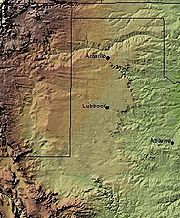
age. These late Cenozoic deposits dominate the Texas Panhandle
Texas Panhandle
The Texas Panhandle is a region of the U.S. state of Texas consisting of the northernmost 26 counties in the state. The panhandle is a rectangular area bordered by New Mexico to the west and Oklahoma to the north and east...
.
The geology of west Texas is arguably the state's most complex, with a mix of exposed Cretaceous and Pennsylvanian strata, overlain by Quaternary
Quaternary
The Quaternary Period is the most recent of the three periods of the Cenozoic Era in the geologic time scale of the ICS. It follows the Neogene Period, spanning 2.588 ± 0.005 million years ago to the present...
conglomerates
Conglomerate (geology)
A conglomerate is a rock consisting of individual clasts within a finer-grained matrix that have become cemented together. Conglomerates are sedimentary rocks consisting of rounded fragments and are thus differentiated from breccias, which consist of angular clasts...
. A series of faults trend southeast to northwest across the region, from Big Bend
Big Bend National Park
Big Bend National Park is a national park located in the U.S. state of Texas. Big Bend has national significance as the largest protected area of Chihuahuan Desert topography and ecology in the United States, which includes more than 1,200 species of plants, more than 450 species of birds, 56...
to El Paso
El Paso, Texas
El Paso, is a city in and the county seat of El Paso County, Texas, United States, and lies in far West Texas. In the 2010 census, the city had a population of 649,121. It is the sixth largest city in Texas and the 19th largest city in the United States...
; there are also extensive volcanic
Volcano
2. Bedrock3. Conduit 4. Base5. Sill6. Dike7. Layers of ash emitted by the volcano8. Flank| 9. Layers of lava emitted by the volcano10. Throat11. Parasitic cone12. Lava flow13. Vent14. Crater15...
deposits. The Marathon Mountains northeast of Big Bend National Park
Big Bend National Park
Big Bend National Park is a national park located in the U.S. state of Texas. Big Bend has national significance as the largest protected area of Chihuahuan Desert topography and ecology in the United States, which includes more than 1,200 species of plants, more than 450 species of birds, 56...
have long been of special interest to geologists; they are the folded and eroded remains of an ancient mountain
Mountain
Image:Himalaya_annotated.jpg|thumb|right|The Himalayan mountain range with Mount Everestrect 58 14 160 49 Chomo Lonzorect 200 28 335 52 Makalurect 378 24 566 45 Mount Everestrect 188 581 920 656 Tibetan Plateaurect 250 406 340 427 Rong River...
range, created in the same orogeny
Orogeny
Orogeny refers to forces and events leading to a severe structural deformation of the Earth's crust due to the engagement of tectonic plates. Response to such engagement results in the formation of long tracts of highly deformed rock called orogens or orogenic belts...
that formed the Ouachita
Ouachita Mountains
The Ouachita Mountains are a mountain range in west central Arkansas and southeastern Oklahoma. The range's subterranean roots may extend as far as central Texas, or beyond it to the current location of the Marathon Uplift. Along with the Ozark Mountains, the Ouachita Mountains form the U.S...
and Appalachian Mountains
Appalachian Mountains
The Appalachian Mountains #Whether the stressed vowel is or ,#Whether the "ch" is pronounced as a fricative or an affricate , and#Whether the final vowel is the monophthong or the diphthong .), often called the Appalachians, are a system of mountains in eastern North America. The Appalachians...
.
Historical geology
Mesoproterozoic
The Mesoproterozoic Era is a geologic era that occurred between 1600 Ma and 1000 Ma . The Mesoproterozoic was the first period of Earth's history with a respectable geological record. Continents existed in the Paleoproterozoic, but we know little about them...
Grenville orogeny
Grenville orogeny
The Grenville Orogeny was a long-lived Mesoproterozoic mountain-building event associated with the assembly of the supercontinent Rodinia. Its record is a prominent orogenic belt which spans a significant portion of the North American continent, from Labrador to Mexico, as well as to Scotland...
, which was part of the assembly of the supercontinent
Supercontinent
In geology, a supercontinent is a landmass comprising more than one continental core, or craton. The assembly of cratons and accreted terranes that form Eurasia qualifies as a supercontinent today.-History:...
Rodinia
Rodinia
In geology, Rodinia is the name of a supercontinent, a continent which contained most or all of Earth's landmass. According to plate tectonic reconstructions, Rodinia existed between 1.1 billion and 750 million years ago, in the Neoproterozoic era...
. Over time, the mountains of the Grenville orogeny were eroded
Erosion
Erosion is when materials are removed from the surface and changed into something else. It only works by hydraulic actions and transport of solids in the natural environment, and leads to the deposition of these materials elsewhere...
flat, and later covered by Paleozoic and Mesozoic sediments that were not uplifted and eroded in their present manner until the late Cenozoic.
Early to middle Paleozoic rocks in Texas are typically carbonate
Carbonate
In chemistry, a carbonate is a salt of carbonic acid, characterized by the presence of the carbonate ion, . The name may also mean an ester of carbonic acid, an organic compound containing the carbonate group C2....
deposited in epeiric seas
Epeiric Sea
An epeiric sea is a shallow sea that extends over part of a continent.Epeiric seas are usually associated with the marine transgressions of the geologic past, which have variously been due to either global eustatic sea level changes, local tectonic deformation, or both, and are occasionally...
. Exceptions include a significant area
of Cambrian
Cambrian
The Cambrian is the first geological period of the Paleozoic Era, lasting from Mya ; it is succeeded by the Ordovician. Its subdivisions, and indeed its base, are somewhat in flux. The period was established by Adam Sedgwick, who named it after Cambria, the Latin name for Wales, where Britain's...
sandstone in west Texas, and some shale strata from the Devonian
Devonian
The Devonian is a geologic period and system of the Paleozoic Era spanning from the end of the Silurian Period, about 416.0 ± 2.8 Mya , to the beginning of the Carboniferous Period, about 359.2 ± 2.5 Mya...
and Mississippian periods. The Ouachita Mountains
Ouachita Mountains
The Ouachita Mountains are a mountain range in west central Arkansas and southeastern Oklahoma. The range's subterranean roots may extend as far as central Texas, or beyond it to the current location of the Marathon Uplift. Along with the Ozark Mountains, the Ouachita Mountains form the U.S...
were uplifted across the state during the succeeding Pennsylvanian period; this provided a nearby source of sediment for shale and sandstone, along with more marine limestone deposition.
Permian
Permian
The PermianThe term "Permian" was introduced into geology in 1841 by Sir Sir R. I. Murchison, president of the Geological Society of London, who identified typical strata in extensive Russian explorations undertaken with Edouard de Verneuil; Murchison asserted in 1841 that he named his "Permian...
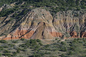
rocks are the best-known of the Texas Paleozoic. They are widespread in north Texas, where their characteristic red beds
Red beds
Red beds are sedimentary rocks, which typically consist of sandstone, siltstone, and shale that are predominantly red in color due to the presence of ferric oxides. Frequently, these red-colored sedimentary strata locally contain thin beds of conglomerate, marl, limestone, or some combination of...
are spectacularly exposed in Palo Duro Canyon
Palo Duro Canyon
Palo Duro Canyon is a canyon system of the Caprock Escarpment located in the Texas Panhandle near the city of Amarillo, Texas, United States. As the second largest canyon in the United States, it is roughly long and has an average width of , but reaches a width of at places. Its depth is around...
. The strata are also oil-rich where buried in west Texas, such as in the Midland
Midland, Texas
Midland is a city in and the county seat of Midland County, Texas, United States, on the Southern Plains of the state's western area. A small portion of the city extends into Martin County. As of 2010, the population of Midland was 111,147. It is the principal city of the Midland, Texas...
and Odessa
Odessa, Texas
Odessa is a city in and the county seat of Ector County, Texas, United States. It is located primarily in Ector County, although a small portion of the city extends into Midland County. Odessa's population was 99,940 at the 2010 census. It is the principal city of the Odessa, Texas Metropolitan...
region. This crude oil rich area is known as the Permian Basin. Permian Texas was covered by shallow seas to the west, with evaporation flats to the east and north in the Panhandle. Outstanding exposures of Permian strata are located in and around Guadalupe Mountains National Park
Guadalupe Mountains National Park
Guadalupe Mountains National Park is located in the Guadalupe Mountains of West Texas and contains Guadalupe Peak, the highest point in Texas at in elevation. It also contains El Capitan, long used as a landmark by people traveling along the old route later followed by the Butterfield Overland...
, the geology of which resulted in the definition of several Permian stratotypes
Global Boundary Stratotype Section and Point
A Global Boundary Stratotype Section and Point, abbreviated GSSP, is an internationally agreed upon stratigraphic section which serves as the reference section for a particular boundary on the geologic time scale. The effort to define GSSPs is conducted by the International Commission on...
; the region is one of the world's best for studies of the period.http://www.eos.ubc.ca/public/resources/slidesets/guad/slidefiles/guadc0.html,http://www.stratigraphy.org/gssp.htm
Early and middle Mesozoic strata are, on the whole, poorly represented in Texas. Triassic rocks are limited to sandstone and shale in the Panhandle, while the Jurassic record is almost nonexistent at the surface. This was far from a monotonous time, though, as it featured the creation of the Gulf of Mexico
Gulf of Mexico
The Gulf of Mexico is a partially landlocked ocean basin largely surrounded by the North American continent and the island of Cuba. It is bounded on the northeast, north and northwest by the Gulf Coast of the United States, on the southwest and south by Mexico, and on the southeast by Cuba. In...
, from a rift southeast of the Ouachita Mountains. Deeply-buried salt deposits and marine limestones under the coastal plain date from the Jurassic
Jurassic
The Jurassic is a geologic period and system that extends from about Mya to Mya, that is, from the end of the Triassic to the beginning of the Cretaceous. The Jurassic constitutes the middle period of the Mesozoic era, also known as the age of reptiles. The start of the period is marked by...
, when the first shallow seas formed.
The late Mesozoic record is much richer. Cretaceous rocks--particularly those of the lower Cretaceous--are widespread at
the surface, with yet more buried under the coastal plain. The strata consist of massive limestone sequences deposited when the
entire region was submerged under the Western Interior Seaway
Western Interior Seaway
The Western Interior Seaway, also called the Cretaceous Seaway, the Niobraran Sea, and the North American Inland Sea, was a huge inland sea that split the continent of North America into two halves, Laramidia and Appalachia, during most of the mid- and late-Cretaceous Period...
, during the last great marine transgression.
The Western Interior Seaway had withdrawn by the beginning of the
Cenozoic, the era that put the finishing touch on Texas's current
geology. The modern coastal plain formed during this time; it
comprises increasingly thick sediments (perhaps 15 km deep at
the coastline) deposited southeastward into the downwarping
Gulf of Mexico.
West Texas was rent by volcanism during the Eocene
Eocene
The Eocene Epoch, lasting from about 56 to 34 million years ago , is a major division of the geologic timescale and the second epoch of the Paleogene Period in the Cenozoic Era. The Eocene spans the time from the end of the Palaeocene Epoch to the beginning of the Oligocene Epoch. The start of the...
and Oligocene
Oligocene
The Oligocene is a geologic epoch of the Paleogene Period and extends from about 34 million to 23 million years before the present . As with other older geologic periods, the rock beds that define the period are well identified but the exact dates of the start and end of the period are slightly...
epochs, activity which formed most of the modern topography of the area. Later crustal extension created a series of alternating horsts and graben
Graben
In geology, a graben is a depressed block of land bordered by parallel faults. Graben is German for ditch. Graben is used for both the singular and plural....
s similar to those in the Basin and Range
Basin and Range
The Basin and Range Province is a vast physiographic region defined by a unique topographic expression. Basin and Range topography is characterized by abrupt changes in elevation, alternating between narrow faulted mountain chains and flat arid valleys or basins...
province of the western U.S. A late Cenozoic uplift of the Rocky Mountains
Rocky Mountains
The Rocky Mountains are a major mountain range in western North America. The Rocky Mountains stretch more than from the northernmost part of British Columbia, in western Canada, to New Mexico, in the southwestern United States...
led to the deposition of a vast fan of eroded sediment to their east, forming the Ogallala Formation
Ogallala Aquifer
The Ogallala Aquifer, also known as the High Plains Aquifer, is a vast yet shallow underground water table aquifer located beneath the Great Plains in the United States...
that covers much of the Panhandle. Most of the state's current stream valleys and canyons date from the Pleistocene
Pleistocene
The Pleistocene is the epoch from 2,588,000 to 11,700 years BP that spans the world's recent period of repeated glaciations. The name pleistocene is derived from the Greek and ....
to the present, as the final geologic shaping of the state.
Economic geology
Texas has been one of the leading states in petroleumPetroleum
Petroleum or crude oil is a naturally occurring, flammable liquid consisting of a complex mixture of hydrocarbons of various molecular weights and other liquid organic compounds, that are found in geologic formations beneath the Earth's surface. Petroleum is recovered mostly through oil drilling...
production since discovery of the Spindletop
Spindletop
Spindletop is a salt dome oil field located in the southern portion of Beaumont, Texas in the United States. The Spindletop dome was derived from the Louann Salt evaporite layer of the Jurassic geologic period. On January 10, 1901, a well at Spindletop struck oil . The new oil field soon produced...
oil field in 1901. The state also produces uranium
Uranium
Uranium is a silvery-white metallic chemical element in the actinide series of the periodic table, with atomic number 92. It is assigned the chemical symbol U. A uranium atom has 92 protons and 92 electrons, of which 6 are valence electrons...
. In past years, the state has also produced mercury
Mercury (element)
Mercury is a chemical element with the symbol Hg and atomic number 80. It is also known as quicksilver or hydrargyrum...
, silver
Silver
Silver is a metallic chemical element with the chemical symbol Ag and atomic number 47. A soft, white, lustrous transition metal, it has the highest electrical conductivity of any element and the highest thermal conductivity of any metal...
, and copper
Copper
Copper is a chemical element with the symbol Cu and atomic number 29. It is a ductile metal with very high thermal and electrical conductivity. Pure copper is soft and malleable; an exposed surface has a reddish-orange tarnish...
.
See also
- Mount BlancoMount BlancoMount Blanco is a small white hill — an erosional remnant — located on the eastern border of the Llano Estacado within Blanco Canyon in Crosby County, Texas...
- Mount BonnellMount BonnellMount Bonnell , also known as Covert Park, is a prominent point alongside Lake Austin portion of the Colorado River in Austin, Texas. It has been a popular tourist destination since the 1850s. The mount provides a vista for viewing the city of Austin, Lake Austin, and the surrounding hills...
- Llano EstacadoLlano EstacadoLlano Estacado , commonly known as the Staked Plains, is a region in the Southwestern United States that encompasses parts of eastern New Mexico and northwestern Texas, including the South Plains and parts of the Texas Panhandle...
- Palo Duro CanyonPalo Duro CanyonPalo Duro Canyon is a canyon system of the Caprock Escarpment located in the Texas Panhandle near the city of Amarillo, Texas, United States. As the second largest canyon in the United States, it is roughly long and has an average width of , but reaches a width of at places. Its depth is around...
- Caprock CanyonsCaprock Canyons State Park and TrailwayCaprock Canyons State Park and Trailway is a Texas state park on the Caprock Escarpment in Briscoe County, Texas, United States, approximately southeast of Amarillo...
- Basic geologic features of each state
- Geology of North America
- Extreme point of Texas