
Wasatch Fault
Encyclopedia
- Not to be confused with the Wasatch FrontWasatch FrontThe Wasatch Front is a metropolitan region in the north-central part of the U.S. state of Utah. It consists of a chain of cities and towns stretched along the Wasatch Range from approximately Santaquin in the south to Brigham City in the north...
Earthquake
An earthquake is the result of a sudden release of energy in the Earth's crust that creates seismic waves. The seismicity, seismism or seismic activity of an area refers to the frequency, type and size of earthquakes experienced over a period of time...
fault located primarily on the western edge of the Wasatch Mountains in the U.S.
United States
The United States of America is a federal constitutional republic comprising fifty states and a federal district...
state of Utah
Utah
Utah is a state in the Western United States. It was the 45th state to join the Union, on January 4, 1896. Approximately 80% of Utah's 2,763,885 people live along the Wasatch Front, centering on Salt Lake City. This leaves vast expanses of the state nearly uninhabited, making the population the...
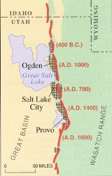
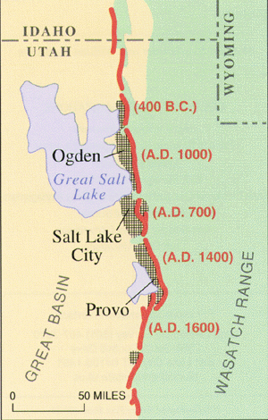
. The fault is 240 miles long, stretching from southern Idaho, through northern Utah, before terminating in central Utah near the town of Fayette. It is made up of several segments, on average 25 miles long, each of which can independently produce earthquakes as powerful as local magnitude 7.5.
The Wasatch Fault is a normal (vertical motion) fault which forms the eastern boundary of the Basin and Range
Basin and Range
The Basin and Range Province is a vast physiographic region defined by a unique topographic expression. Basin and Range topography is characterized by abrupt changes in elevation, alternating between narrow faulted mountain chains and flat arid valleys or basins...
geologic province which comprises the geographic Great Basin
Great Basin
The Great Basin is the largest area of contiguous endorheic watersheds in North America and is noted for its arid conditions and Basin and Range topography that varies from the North American low point at Badwater Basin to the highest point of the contiguous United States, less than away at the...
. The Wasatch Mountains have been uplifted and tilted to the east by movement of the fault. The average rate of uplift along the fault over its history is approximately 1 mm per year, although there are indications that more rapid slip has occurred in the past few thousand years. The fault, however, does not continually slowly slip; instead, it remains locked for hundreds to thousands of years until approximately 1 to 4 meters of slip occurs rapidly, producing a strong earthquake.
Geological history
During the past 6,000 years, a strong earthquake (magnitude greater than 6.5) has occurred approximately once every 350 years somewhere along one of the central segments of the Wasatch Fault. The segments that underlie Salt Lake City and ProvoProvo, Utah
Provo is the third largest city in the U.S. state of Utah, located about south of Salt Lake City along the Wasatch Front. Provo is the county seat of Utah County and lies between the cities of Orem to the north and Springville to the south...
produce a large earthquake on average every 1,300 years. The last major earthquake on the Salt Lake City segment was about 1,300 years ago, and on adjoining segments around 2,100 years ago. Experts note that the fault is overdue for another major earthquake, and media coverage of the threat has increased in recent years, bringing greater awareness of the threat to residents of the region. As awareness has increased since the 1980s, many key structures in the region have been undergoing extensive seismic retrofitting, reservoirs on the fault have been drained, and development in at-risk areas curtailed. The urban areas of the Wasatch Front
Wasatch Front
The Wasatch Front is a metropolitan region in the north-central part of the U.S. state of Utah. It consists of a chain of cities and towns stretched along the Wasatch Range from approximately Santaquin in the south to Brigham City in the north...
lie on soft lake sediments, a remnant of Lake Bonneville
Lake Bonneville
Lake Bonneville was a prehistoric pluvial lake that covered much of North America's Great Basin region. Most of the territory it covered was in present-day Utah, though parts of the lake extended into present-day Idaho and Nevada. Formed about 32,000 years ago, it existed until about 14,500 years...
. During strong earthquakes, this sediment will cause soil liquefaction
Soil liquefaction
Soil liquefaction describes a phenomenon whereby a saturated soil substantially loses strength and stiffness in response to an applied stress, usually earthquake shaking or other sudden change in stress condition, causing it to behave like a liquid....
, which acts as quicksand
Quicksand
Quicksand is a colloid hydrogel consisting of fine granular matter , clay, and water.Water circulation underground can focus in an area with the optimal mixture of fine sands and other materials such as clay. The water moves up and then down slowly in a convection-like manner throughout a column...
. An earthquake on the Wasatch Fault could severely damage gas, electric, water, communication, and transportation lifelines, crippling the 2,000,000-strong Wasatch Front
Wasatch Front
The Wasatch Front is a metropolitan region in the north-central part of the U.S. state of Utah. It consists of a chain of cities and towns stretched along the Wasatch Range from approximately Santaquin in the south to Brigham City in the north...
urban area.
A recent report released by Bob Carey of Utah's Office of Emergency Services and published by the Deseret Morning News
Deseret Morning News
The Deseret News is a newspaper published in Salt Lake City, Utah, and is Utah's oldest continuously published daily newspaper. It has the second largest daily circulation in the state behind The Salt Lake Tribune. The Deseret News is owned by Deseret News Publishing Company, a subsidiary of...
in April 2006 predicts what the possible results of a 7.0 earthquake directly hitting the Salt Lake Valley
Salt Lake Valley
Salt Lake Valley is a valley in Salt Lake County in the north-central portion of the U.S. state of Utah. It contains Salt Lake City and many of its suburbs, notably West Valley City, Murray, Sandy, and West Jordan; its total population is 1,029,655 as of 2010...
could be. The report predicts that when the quake strikes, it could kill up to 6,200 people, injure at least 90,000, and cause $40 billion USD in economic losses. At least 42% of all buildings along the Wasatch Front could be at least moderately damaged. The earthquake danger was not known when many structures were built in the area, as many hospitals and schools are located atop the faults themselves. About 50% of hospital beds could be eliminated during a quake and the region has about 200,000 unreinforced masonry building
Unreinforced masonry building
An Unreinforced masonry building is a type of building where load bearing walls, non-load bearing walls or other structures, such as chimneys are made of brick, cinderblock, tiles, adobe or other masonry material, that is not braced by reinforcing beams...
s – buildings particularly vulnerable to shaking – compared to California state's 25,000. Massive landslides are another major threat.