

Geology of the Appalachians
Encyclopedia
The geology of the Appalachians dates back to more than 480 million years ago. A look at rocks exposed in today's Appalachian Mountains
reveals elongate belts of fold
ed and thrust fault
ed marine sedimentary rock
s, volcanic rock
s and slivers of ancient ocean floor - strong evidence that these rocks were deformed during plate collision
. The birth of the Appalachian ranges marks the first of several mountain building plate collisions that culminated in the construction of the supercontinent
Pangaea
with the Appalachians and neighboring Little Atlas (now in Morocco) near the center. These mountain ranges were once higher than today's Himalaya mountain range
, which was also formed by continental collision.
 During the earliest Paleozoic
Era, the continent that would later become North America
straddled the equator
. The Appalachian region was a passive plate margin, not unlike today's Atlantic Coastal Plain
Province. During this interval, the region was periodically submerged beneath shallow seas. Thick layers of sediment and carbonate rock
were deposited on the shallow sea bottom when the region was submerged. When seas receded, terrestrial sedimentary deposits and erosion dominated.
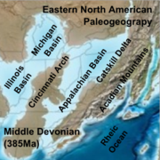
During the middle Ordovician
Period (about 480-440 million years ago), a change in plate motions set the stage for the first Paleozoic mountain building event (Taconic orogeny
) in North America. The once quiet Appalachian passive margin changed to a very active plate boundary when a neighboring oceanic plate, the Iapetus
, collided with and began sinking beneath the North American craton
. With the creation of this new subduction zone, the early Appalachians were born.
Along the continental margin
, volcano
es grew, coincident with the initiation of subduction. Thrust faulting uplifted and warped older sedimentary rock laid down on the passive margin. As mountains rose, erosion
began to wear them down. Streams carried rock debris downslope to be deposited in nearby lowland
s.
This was just the first of a series of mountain building plate collisions that contributed to the formation of the Appalachians. Mountain building continued periodically throughout the next 250 million years (Caledonian
, Acadian
, Ouachita
, Hercynian, and Allegheny
orogenies). Continent after continent was thrust and sutured onto the North American craton as the Pangean supercontinent began to take shape. Microplates
, smaller bits of crust, too small to be called continents, were swept in, one by one, to be welded to the growing mass.
By about 300 million years ago (Pennsylvanian
Period) Africa
was approaching the North American craton. The collisional belt spread into the Ozark-Ouachita
region and through the Marathon Mountains
area of Texas. Continent vs. continent collision raised the Appalachian-Ouachita chain to lofty, Himalayan-scale ranges. The massive bulk of Pangea was completed near the end of the Paleozoic Era (Permian
Period) when Africa (Gondwana
) plowed into the continental agglomeration, with the Appalachian-Ouachita mountains near the core.
Era (Late Triassic
Period). As Pangea rifted apart a new passive tectonic margin was born and the forces that created the Appalachian, Ouachita, and Marathon Mountains were stilled. Weathering and erosion prevailed, and the mountains began to wear away.
By the end of the Mesozoic
Era, the Appalachian Mountains had been eroded to an almost flat plain. It was not until the region was uplifted during the Cenozoic
Era that the distinctive topography of the present formed. Uplift rejuvenated
the streams, which rapidly responded by cutting downward into the ancient bedrock. Some streams flowed along weak layers that define the folds and faults created many millions of years earlier. Other streams downcut
so rapidly that they cut right across the resistant folded rocks of the mountain core, carving canyons across rock layers and geologic structures.
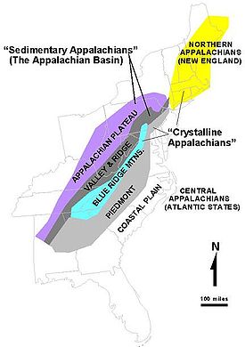 The Appalachian Mountains span across five geologic provinces (as defined by the USGS): the Appalachian Basin, the Blue Ridge Mountains, the Piedmont Province, the Adirondack Province, and the New England Province.
sedimentary rock
s of Early Cambrian through Early Permian age. From north to south, the Appalachian Basin Province crosses New York
, Pennsylvania
, eastern Ohio
, West Virginia
, western Maryland
, eastern Kentucky
, western Virginia
, eastern Tennessee
, northwestern Georgia
, and northeastern Alabama
. The northern end of the Appalachian Basin extends offshore into Lakes Erie
and Ontario
as far as the United States–Canada border. The Appalachian Basin province covers an area of about 185500 mi2. The province is 1075 miles (1,730 km) long from northeast to southwest and between 20 to 310 mi (32.2 to 498.9 km) wide from northwest to southeast.
The northwestern flank of the basin is a broad homocline
that dips gently southeastward off the Cincinnati Arch
. A complexly thrust faulted and folded terrane
(Appalachian Fold and Thrust Belt or Eastern Overthrust Belt), formed at the end of the Paleozoic by the Alleghenian orogeny
, characterizes the eastern flank of the basin. Metamorphic and igneous rocks of the Blue Ridge Thrust Belt that bounds the eastern part of the Appalachian Basin Province were thrust westward more than 150 miles (241.4 km) over lower Paleozoic sedimentary rocks.
producing regions in the US and one of the biggest in the world. Appalachian Basin bituminous coal
has been mined throughout the last three centuries. Currently, the coal primarily is used within the eastern U.S. for electrical power generation, but some of it is suitable for metallurgical
uses. Economically important coal beds were deposited primarily during Pennsylvanian
time in a southeastward-thickening foreland basin
. Coal and associated rocks form a clastic wedge that
thickens from north to south, from Pennsylvania into southeast West Virginia and southwestern Virginia.
The Appalachian Basin has had a long history of oil and gas production. Discovery of oil in 1859 in the Drake well, Venango County, Pennsylvania
, marked the beginning of the oil and gas industry in the Appalachian Basin. discovery well opened a prolific trend of oil and gas fields, producing from Upper Devonian, Mississippian, and Pennsylvanian sandstone
reservoirs, that extends from southern New York, across western Pennsylvania, central West Virginia, and eastern Ohio, to eastern Kentucky.
A second major trend of oil and gas production in the Appalachian Basin began with the discovery in 1885 of oil and gas in Lower Silurian Clinton sandstone reservoirs in Knox County, Ohio
. By the late 1880s and early 1900s, the trend extended both north and south across east-central Ohio and included several counties in western New York where gas was discovered in Lower Silurian Medina Group sandstones. About 1900, large oil reserves were discovered in Silurian
and Devonian
carbonate
reservoirs in east-central Kentucky. Important gas discoveries from the Lower Devonian Oriskany Sandstone in Cambridge County, Ohio, in 1924, Schuyler County, New York
, in 1930, and Kanawha County, West Virginia
, in 1936 opened a major gas-producing trend across parts of New York, Pennsylvania, Maryland, Ohio, West Virginia, Kentucky, and Virginia.
Another drilling boom in the Appalachian Basin occurred in the 1960s in Morrow County, Ohio
, where oil was discovered in the Upper Cambrian part of the Knox Dolomite
.
The Blue Ridge Thrust Belt Province underlies parts of eight States from central Alabama to southern Pennsylvania. Along its western margin, the Blue Ridge is thrust over the folded and faulted margin of the Appalachian basin, so that a broad segment of Paleozoic strata extends eastward for tens of miles, buried beneath these subhorizontal crystalline thrust sheets. At the surface, the Blue Ridge consists of a mountainous to hilly region, the main component of which are the Blue Ridge Mountains
that extend from Georgia to Pennsylvania. Surface rocks consist mainly of a core of moderate-to high-rank crystalline metamorphic or igneous rocks, which, because of their superior resistance to weathering and erosion, commonly rise above the adjacent areas of low-grade metamorphic and sedimentary rock. The province is bounded on the north and west by the Paleozoic strata of the Appalachian Basin Province and on the south by Cretaceous and younger sedimentary rocks of the Gulf Coastal Plain. It is bounded on the east by metamorphic and sedimentary rocks of the Piedmont Province.
The Adirondack and New England Provinces include sedimentary, metasedimentary, and plutonic igneous rocks, mainly of Cambrian and Ordovician age, similar lithologically to rocks in the Blue Ridge and Piedmont Provinces to the south. The uplifted, nearly circular Adirondack Mountains
consist of a core of ancient Precambrian
rocks that are surrounded by upturned Cambrian and Ordovician
sedimentary rocks.
Appalachian Mountains
The Appalachian Mountains #Whether the stressed vowel is or ,#Whether the "ch" is pronounced as a fricative or an affricate , and#Whether the final vowel is the monophthong or the diphthong .), often called the Appalachians, are a system of mountains in eastern North America. The Appalachians...
reveals elongate belts of fold
Fold (geology)
The term fold is used in geology when one or a stack of originally flat and planar surfaces, such as sedimentary strata, are bent or curved as a result of permanent deformation. Synsedimentary folds are those due to slumping of sedimentary material before it is lithified. Folds in rocks vary in...
ed and thrust fault
Thrust fault
A thrust fault is a type of fault, or break in the Earth's crust across which there has been relative movement, in which rocks of lower stratigraphic position are pushed up and over higher strata. They are often recognized because they place older rocks above younger...
ed marine sedimentary rock
Sedimentary rock
Sedimentary rock are types of rock that are formed by the deposition of material at the Earth's surface and within bodies of water. Sedimentation is the collective name for processes that cause mineral and/or organic particles to settle and accumulate or minerals to precipitate from a solution....
s, volcanic rock
Volcanic rock
Volcanic rock is a rock formed from magma erupted from a volcano. In other words, it is an igneous rock of volcanic origin...
s and slivers of ancient ocean floor - strong evidence that these rocks were deformed during plate collision
Plate tectonics
Plate tectonics is a scientific theory that describes the large scale motions of Earth's lithosphere...
. The birth of the Appalachian ranges marks the first of several mountain building plate collisions that culminated in the construction of the supercontinent
Supercontinent
In geology, a supercontinent is a landmass comprising more than one continental core, or craton. The assembly of cratons and accreted terranes that form Eurasia qualifies as a supercontinent today.-History:...
Pangaea
Pangaea
Pangaea, Pangæa, or Pangea is hypothesized as a supercontinent that existed during the Paleozoic and Mesozoic eras about 250 million years ago, before the component continents were separated into their current configuration....
with the Appalachians and neighboring Little Atlas (now in Morocco) near the center. These mountain ranges were once higher than today's Himalaya mountain range
Geology of the Himalaya
The geology of the Himalaya is a record of the most dramatic and visible creations of modern plate tectonic forces. The Himalayas, which stretch over 2400 km between the Namche Barwa syntaxis in Tibet and the Nanga Parbat syntaxis in Pakistan, are the result of an ongoing orogeny — the result...
, which was also formed by continental collision.
Paleozoic Era
Paleozoic
The Paleozoic era is the earliest of three geologic eras of the Phanerozoic eon, spanning from roughly...
Era, the continent that would later become North America
North America
North America is a continent wholly within the Northern Hemisphere and almost wholly within the Western Hemisphere. It is also considered a northern subcontinent of the Americas...
straddled the equator
Equator
An equator is the intersection of a sphere's surface with the plane perpendicular to the sphere's axis of rotation and containing the sphere's center of mass....
. The Appalachian region was a passive plate margin, not unlike today's Atlantic Coastal Plain
Atlantic Coastal Plain
The Atlantic coastal plain has both low elevation and low relief, but it is also a relatively flat landform extending from the New York Bight southward to a Georgia/Florida section of the Eastern Continental Divide, which demarcates the plain from the ACF River Basin in the Gulf Coastal Plain to...
Province. During this interval, the region was periodically submerged beneath shallow seas. Thick layers of sediment and carbonate rock
Carbonate rock
Carbonate rocks are a class of sedimentary rocks composed primarily of carbonate minerals. The two major types are limestone, which is composed of calcite or aragonite and dolostone, which is composed of the mineral dolomite .Calcite can be either dissolved by groundwater or precipitated by...
were deposited on the shallow sea bottom when the region was submerged. When seas receded, terrestrial sedimentary deposits and erosion dominated.
During the middle Ordovician
Ordovician
The Ordovician is a geologic period and system, the second of six of the Paleozoic Era, and covers the time between 488.3±1.7 to 443.7±1.5 million years ago . It follows the Cambrian Period and is followed by the Silurian Period...
Period (about 480-440 million years ago), a change in plate motions set the stage for the first Paleozoic mountain building event (Taconic orogeny
Taconic orogeny
The Taconic orogeny was a mountain building period that ended 440 million years ago and affected most of modern-day New England. A great mountain chain formed from eastern Canada down through what is now the Piedmont of the East coast of the United States...
) in North America. The once quiet Appalachian passive margin changed to a very active plate boundary when a neighboring oceanic plate, the Iapetus
Iapetus Ocean
The Iapetus Ocean was an ocean that existed in the Neoproterozoic and Paleozoic eras of the geologic timescale . The Iapetus Ocean was situated in the southern hemisphere, between the paleocontinents of Laurentia, Baltica and Avalonia...
, collided with and began sinking beneath the North American craton
Craton
A craton is an old and stable part of the continental lithosphere. Having often survived cycles of merging and rifting of continents, cratons are generally found in the interiors of tectonic plates. They are characteristically composed of ancient crystalline basement rock, which may be covered by...
. With the creation of this new subduction zone, the early Appalachians were born.
Along the continental margin
Continental margin
The continental margin is the zone of the ocean floor that separates the thin oceanic crust from thick continental crust. Continental margins constitute about 28% of the oceanic area....
, volcano
Volcano
2. Bedrock3. Conduit 4. Base5. Sill6. Dike7. Layers of ash emitted by the volcano8. Flank| 9. Layers of lava emitted by the volcano10. Throat11. Parasitic cone12. Lava flow13. Vent14. Crater15...
es grew, coincident with the initiation of subduction. Thrust faulting uplifted and warped older sedimentary rock laid down on the passive margin. As mountains rose, erosion
Erosion
Erosion is when materials are removed from the surface and changed into something else. It only works by hydraulic actions and transport of solids in the natural environment, and leads to the deposition of these materials elsewhere...
began to wear them down. Streams carried rock debris downslope to be deposited in nearby lowland
Lowland
In physical geography, a lowland is any broad expanse of land with a general low level. The term is thus applied to the landward portion of the upward slope from oceanic depths to continental highlands, to a region of depression in the interior of a mountainous region, to a plain of denudation, or...
s.
This was just the first of a series of mountain building plate collisions that contributed to the formation of the Appalachians. Mountain building continued periodically throughout the next 250 million years (Caledonian
Caledonian orogeny
The Caledonian orogeny is a mountain building era recorded in the northern parts of the British Isles, the Scandinavian Mountains, Svalbard, eastern Greenland and parts of north-central Europe. The Caledonian orogeny encompasses events that occurred from the Ordovician to Early Devonian, roughly...
, Acadian
Acadian orogeny
The Taconic, Acadian and Alleghenian orogenies are the three tectonic phases responsible for the formation of the present Appalachian Mountains. The Acadian orogeny is a middle Paleozoic mountain building episode dating back 325-400 million years which should not be regarded as a single event but...
, Ouachita
Ouachita orogeny
The Ouachita orogeny was a mountain building event that resulted in the folding and faulting of strata currently exposed in the Ouachita Mountains...
, Hercynian, and Allegheny
Alleghenian orogeny
The Alleghenian orogeny or Appalachian orogeny is one of the geological mountain-forming events that formed the Appalachian Mountains and Allegheny Mountains. The term and spelling Alleghany orogeny was originally proposed by H.P. Woodward in 1957....
orogenies). Continent after continent was thrust and sutured onto the North American craton as the Pangean supercontinent began to take shape. Microplates
Terrane
A terrane in geology is short-hand term for a tectonostratigraphic terrane, which is a fragment of crustal material formed on, or broken off from, one tectonic plate and accreted or "sutured" to crust lying on another plate...
, smaller bits of crust, too small to be called continents, were swept in, one by one, to be welded to the growing mass.
By about 300 million years ago (Pennsylvanian
Pennsylvanian
The Pennsylvanian is, in the ICS geologic timescale, the younger of two subperiods of the Carboniferous Period. It lasted from roughly . As with most other geochronologic units, the rock beds that define the Pennsylvanian are well identified, but the exact date of the start and end are uncertain...
Period) Africa
Africa
Africa is the world's second largest and second most populous continent, after Asia. At about 30.2 million km² including adjacent islands, it covers 6% of the Earth's total surface area and 20.4% of the total land area...
was approaching the North American craton. The collisional belt spread into the Ozark-Ouachita
Ouachita Mountains
The Ouachita Mountains are a mountain range in west central Arkansas and southeastern Oklahoma. The range's subterranean roots may extend as far as central Texas, or beyond it to the current location of the Marathon Uplift. Along with the Ozark Mountains, the Ouachita Mountains form the U.S...
region and through the Marathon Mountains
Marathon Uplift
The Marathon Uplift is a Tertiary-age domal uplift, approximately in diameter, in southwest Texas. The Marathon Basin was created by erosion of Cretaceous and younger strata from the crest of the uplift...
area of Texas. Continent vs. continent collision raised the Appalachian-Ouachita chain to lofty, Himalayan-scale ranges. The massive bulk of Pangea was completed near the end of the Paleozoic Era (Permian
Permian
The PermianThe term "Permian" was introduced into geology in 1841 by Sir Sir R. I. Murchison, president of the Geological Society of London, who identified typical strata in extensive Russian explorations undertaken with Edouard de Verneuil; Murchison asserted in 1841 that he named his "Permian...
Period) when Africa (Gondwana
Gondwana
In paleogeography, Gondwana , originally Gondwanaland, was the southernmost of two supercontinents that later became parts of the Pangaea supercontinent. It existed from approximately 510 to 180 million years ago . Gondwana is believed to have sutured between ca. 570 and 510 Mya,...
) plowed into the continental agglomeration, with the Appalachian-Ouachita mountains near the core.
Mesozoic Era and later
Pangea began to break up about 220 million years ago, in the Early MesozoicMesozoic
The Mesozoic era is an interval of geological time from about 250 million years ago to about 65 million years ago. It is often referred to as the age of reptiles because reptiles, namely dinosaurs, were the dominant terrestrial and marine vertebrates of the time...
Era (Late Triassic
Triassic
The Triassic is a geologic period and system that extends from about 250 to 200 Mya . As the first period of the Mesozoic Era, the Triassic follows the Permian and is followed by the Jurassic. Both the start and end of the Triassic are marked by major extinction events...
Period). As Pangea rifted apart a new passive tectonic margin was born and the forces that created the Appalachian, Ouachita, and Marathon Mountains were stilled. Weathering and erosion prevailed, and the mountains began to wear away.
By the end of the Mesozoic
Mesozoic
The Mesozoic era is an interval of geological time from about 250 million years ago to about 65 million years ago. It is often referred to as the age of reptiles because reptiles, namely dinosaurs, were the dominant terrestrial and marine vertebrates of the time...
Era, the Appalachian Mountains had been eroded to an almost flat plain. It was not until the region was uplifted during the Cenozoic
Cenozoic
The Cenozoic era is the current and most recent of the three Phanerozoic geological eras and covers the period from 65.5 mya to the present. The era began in the wake of the Cretaceous–Tertiary extinction event at the end of the Cretaceous that saw the demise of the last non-avian dinosaurs and...
Era that the distinctive topography of the present formed. Uplift rejuvenated
Rejuvenation (river)
A river is said to be rejuvenated when the base level that it is flowing down to is lowered. This can happen for various reasons.-Signs:Rejuvenated terrains usually have complex landscapes because remnants of older landforms are locally preserved. Parts of floodplains may be preserved as terraces...
the streams, which rapidly responded by cutting downward into the ancient bedrock. Some streams flowed along weak layers that define the folds and faults created many millions of years earlier. Other streams downcut
Downcutting
Downcutting, also called erosional downcutting or downward erosion or vertical erosion is a geological process that deepens the channel of a stream or valley by removing material from the stream's bed or the valley's floor. How fast downcutting occurs depends on the stream's base level, which is...
so rapidly that they cut right across the resistant folded rocks of the mountain core, carving canyons across rock layers and geologic structures.
Geologic provinces
The Appalachian Basin
The Appalachian Basin is a foreland basin containing PaleozoicPaleozoic
The Paleozoic era is the earliest of three geologic eras of the Phanerozoic eon, spanning from roughly...
sedimentary rock
Sedimentary rock
Sedimentary rock are types of rock that are formed by the deposition of material at the Earth's surface and within bodies of water. Sedimentation is the collective name for processes that cause mineral and/or organic particles to settle and accumulate or minerals to precipitate from a solution....
s of Early Cambrian through Early Permian age. From north to south, the Appalachian Basin Province crosses New York
New York
New York is a state in the Northeastern region of the United States. It is the nation's third most populous state. New York is bordered by New Jersey and Pennsylvania to the south, and by Connecticut, Massachusetts and Vermont to the east...
, Pennsylvania
Pennsylvania
The Commonwealth of Pennsylvania is a U.S. state that is located in the Northeastern and Mid-Atlantic regions of the United States. The state borders Delaware and Maryland to the south, West Virginia to the southwest, Ohio to the west, New York and Ontario, Canada, to the north, and New Jersey to...
, eastern Ohio
Ohio
Ohio is a Midwestern state in the United States. The 34th largest state by area in the U.S.,it is the 7th‑most populous with over 11.5 million residents, containing several major American cities and seven metropolitan areas with populations of 500,000 or more.The state's capital is Columbus...
, West Virginia
West Virginia
West Virginia is a state in the Appalachian and Southeastern regions of the United States, bordered by Virginia to the southeast, Kentucky to the southwest, Ohio to the northwest, Pennsylvania to the northeast and Maryland to the east...
, western Maryland
Maryland
Maryland is a U.S. state located in the Mid Atlantic region of the United States, bordering Virginia, West Virginia, and the District of Columbia to its south and west; Pennsylvania to its north; and Delaware to its east...
, eastern Kentucky
Kentucky
The Commonwealth of Kentucky is a state located in the East Central United States of America. As classified by the United States Census Bureau, Kentucky is a Southern state, more specifically in the East South Central region. Kentucky is one of four U.S. states constituted as a commonwealth...
, western Virginia
Virginia
The Commonwealth of Virginia , is a U.S. state on the Atlantic Coast of the Southern United States. Virginia is nicknamed the "Old Dominion" and sometimes the "Mother of Presidents" after the eight U.S. presidents born there...
, eastern Tennessee
Tennessee
Tennessee is a U.S. state located in the Southeastern United States. It has a population of 6,346,105, making it the nation's 17th-largest state by population, and covers , making it the 36th-largest by total land area...
, northwestern Georgia
Georgia (U.S. state)
Georgia is a state located in the southeastern United States. It was established in 1732, the last of the original Thirteen Colonies. The state is named after King George II of Great Britain. Georgia was the fourth state to ratify the United States Constitution, on January 2, 1788...
, and northeastern Alabama
Alabama
Alabama is a state located in the southeastern region of the United States. It is bordered by Tennessee to the north, Georgia to the east, Florida and the Gulf of Mexico to the south, and Mississippi to the west. Alabama ranks 30th in total land area and ranks second in the size of its inland...
. The northern end of the Appalachian Basin extends offshore into Lakes Erie
Lake Erie
Lake Erie is the fourth largest lake of the five Great Lakes in North America, and the tenth largest globally. It is the southernmost, shallowest, and smallest by volume of the Great Lakes and therefore also has the shortest average water residence time. It is bounded on the north by the...
and Ontario
Lake Ontario
Lake Ontario is one of the five Great Lakes of North America. It is bounded on the north and southwest by the Canadian province of Ontario, and on the south by the American state of New York. Ontario, Canada's most populous province, was named for the lake. In the Wyandot language, ontarío means...
as far as the United States–Canada border. The Appalachian Basin province covers an area of about 185500 mi2. The province is 1075 miles (1,730 km) long from northeast to southwest and between 20 to 310 mi (32.2 to 498.9 km) wide from northwest to southeast.
The northwestern flank of the basin is a broad homocline
Homocline
In structural geology, a uniclinal structure, homoclinal structure, unicline or homocline is a sedimentary rock unit, which may also be associated with a stratigraphic landform, where the underlying strata are tilted in the same direction, especially with near uniform dip angle...
that dips gently southeastward off the Cincinnati Arch
Cincinnati Arch
The Cincinnati Arch is a broad structural uplift between the Illinois Basin to the west, the Michigan Basin to the northwest and the Appalachian Basin and Black Warrior Basin to the east and southeast. It existed as a positive topographic area during Late Ordovician through the Devonian Period...
. A complexly thrust faulted and folded terrane
Terrane
A terrane in geology is short-hand term for a tectonostratigraphic terrane, which is a fragment of crustal material formed on, or broken off from, one tectonic plate and accreted or "sutured" to crust lying on another plate...
(Appalachian Fold and Thrust Belt or Eastern Overthrust Belt), formed at the end of the Paleozoic by the Alleghenian orogeny
Alleghenian orogeny
The Alleghenian orogeny or Appalachian orogeny is one of the geological mountain-forming events that formed the Appalachian Mountains and Allegheny Mountains. The term and spelling Alleghany orogeny was originally proposed by H.P. Woodward in 1957....
, characterizes the eastern flank of the basin. Metamorphic and igneous rocks of the Blue Ridge Thrust Belt that bounds the eastern part of the Appalachian Basin Province were thrust westward more than 150 miles (241.4 km) over lower Paleozoic sedimentary rocks.
Coal, oil, and gas production
The Appalachian Basin is one of the most important coalCoal
Coal is a combustible black or brownish-black sedimentary rock usually occurring in rock strata in layers or veins called coal beds or coal seams. The harder forms, such as anthracite coal, can be regarded as metamorphic rock because of later exposure to elevated temperature and pressure...
producing regions in the US and one of the biggest in the world. Appalachian Basin bituminous coal
Bituminous coal
Bituminous coal or black coal is a relatively soft coal containing a tarlike substance called bitumen. It is of higher quality than lignite coal but of poorer quality than Anthracite...
has been mined throughout the last three centuries. Currently, the coal primarily is used within the eastern U.S. for electrical power generation, but some of it is suitable for metallurgical
Metallurgy
Metallurgy is a domain of materials science that studies the physical and chemical behavior of metallic elements, their intermetallic compounds, and their mixtures, which are called alloys. It is also the technology of metals: the way in which science is applied to their practical use...
uses. Economically important coal beds were deposited primarily during Pennsylvanian
Pennsylvanian
The Pennsylvanian is, in the ICS geologic timescale, the younger of two subperiods of the Carboniferous Period. It lasted from roughly . As with most other geochronologic units, the rock beds that define the Pennsylvanian are well identified, but the exact date of the start and end are uncertain...
time in a southeastward-thickening foreland basin
Foreland basin
A foreland basin is a depression that develops adjacent and parallel to a mountain belt. Foreland basins form because the immense mass created by crustal thickening associated with the evolution of a mountain belt causes the lithosphere to bend, by a process known as lithospheric flexure...
. Coal and associated rocks form a clastic wedge that
thickens from north to south, from Pennsylvania into southeast West Virginia and southwestern Virginia.
The Appalachian Basin has had a long history of oil and gas production. Discovery of oil in 1859 in the Drake well, Venango County, Pennsylvania
Venango County, Pennsylvania
Venango County is a county located in the U.S. state of Pennsylvania. As of the 2010 census, the population was 54,984. Its county seat is Franklin.-History:Venango County was created on March 12, 1800 from parts of Allegheny and Lycoming Counties...
, marked the beginning of the oil and gas industry in the Appalachian Basin. discovery well opened a prolific trend of oil and gas fields, producing from Upper Devonian, Mississippian, and Pennsylvanian sandstone
Sandstone
Sandstone is a sedimentary rock composed mainly of sand-sized minerals or rock grains.Most sandstone is composed of quartz and/or feldspar because these are the most common minerals in the Earth's crust. Like sand, sandstone may be any colour, but the most common colours are tan, brown, yellow,...
reservoirs, that extends from southern New York, across western Pennsylvania, central West Virginia, and eastern Ohio, to eastern Kentucky.
A second major trend of oil and gas production in the Appalachian Basin began with the discovery in 1885 of oil and gas in Lower Silurian Clinton sandstone reservoirs in Knox County, Ohio
Knox County, Ohio
Knox County is a county located in the state of Ohio, United States. As of 2010, the population was 60,921. Its county seat is Mount Vernon and is named for Henry Knox, an officer in the American Revolutionary War who was later the first Secretary of War....
. By the late 1880s and early 1900s, the trend extended both north and south across east-central Ohio and included several counties in western New York where gas was discovered in Lower Silurian Medina Group sandstones. About 1900, large oil reserves were discovered in Silurian
Silurian
The Silurian is a geologic period and system that extends from the end of the Ordovician Period, about 443.7 ± 1.5 Mya , to the beginning of the Devonian Period, about 416.0 ± 2.8 Mya . As with other geologic periods, the rock beds that define the period's start and end are well identified, but the...
and Devonian
Devonian
The Devonian is a geologic period and system of the Paleozoic Era spanning from the end of the Silurian Period, about 416.0 ± 2.8 Mya , to the beginning of the Carboniferous Period, about 359.2 ± 2.5 Mya...
carbonate
Carbonate
In chemistry, a carbonate is a salt of carbonic acid, characterized by the presence of the carbonate ion, . The name may also mean an ester of carbonic acid, an organic compound containing the carbonate group C2....
reservoirs in east-central Kentucky. Important gas discoveries from the Lower Devonian Oriskany Sandstone in Cambridge County, Ohio, in 1924, Schuyler County, New York
Schuyler County, New York
As of the census of 2000, there were 19,224 people, 7,374 households, and 5,191 families residing in the county. The population density was 58 people per square mile . There were 9,181 housing units at an average density of 28 per square mile...
, in 1930, and Kanawha County, West Virginia
Kanawha County, West Virginia
As of the census of 2000, there were 200,073 people, 86,226 households, and 55,960 families residing in the county. The population density was 222 people per square mile . There were 93,788 housing units at an average density of 104 per square mile...
, in 1936 opened a major gas-producing trend across parts of New York, Pennsylvania, Maryland, Ohio, West Virginia, Kentucky, and Virginia.
Another drilling boom in the Appalachian Basin occurred in the 1960s in Morrow County, Ohio
Morrow County, Ohio
Morrow County is a county located in the state of Ohio, United States. Shawnee people used the area for hunting purposes before white settlers arrived in the early 19th century. Morrow County was organized in 1848 from parts of four neighboring counties and named for Jeremiah Morrow, Governor of...
, where oil was discovered in the Upper Cambrian part of the Knox Dolomite
Dolomite
Dolomite is a carbonate mineral composed of calcium magnesium carbonate CaMg2. The term is also used to describe the sedimentary carbonate rock dolostone....
.
Crystalline Appalachians
The Blue Ridge, Piedmont, Adirondack, and New England Provinces are collectively known as the Crystalline Appalachians, because they consist of Precambrian and Cambrian igneous and metamorphic rocks.The Blue Ridge Thrust Belt Province underlies parts of eight States from central Alabama to southern Pennsylvania. Along its western margin, the Blue Ridge is thrust over the folded and faulted margin of the Appalachian basin, so that a broad segment of Paleozoic strata extends eastward for tens of miles, buried beneath these subhorizontal crystalline thrust sheets. At the surface, the Blue Ridge consists of a mountainous to hilly region, the main component of which are the Blue Ridge Mountains
Blue Ridge Mountains
The Blue Ridge Mountains are a physiographic province of the larger Appalachian Mountains range. This province consists of northern and southern physiographic regions, which divide near the Roanoke River gap. The mountain range is located in the eastern United States, starting at its southern-most...
that extend from Georgia to Pennsylvania. Surface rocks consist mainly of a core of moderate-to high-rank crystalline metamorphic or igneous rocks, which, because of their superior resistance to weathering and erosion, commonly rise above the adjacent areas of low-grade metamorphic and sedimentary rock. The province is bounded on the north and west by the Paleozoic strata of the Appalachian Basin Province and on the south by Cretaceous and younger sedimentary rocks of the Gulf Coastal Plain. It is bounded on the east by metamorphic and sedimentary rocks of the Piedmont Province.
The Adirondack and New England Provinces include sedimentary, metasedimentary, and plutonic igneous rocks, mainly of Cambrian and Ordovician age, similar lithologically to rocks in the Blue Ridge and Piedmont Provinces to the south. The uplifted, nearly circular Adirondack Mountains
Adirondack Mountains
The Adirondack Mountains are a mountain range located in the northeastern part of New York, that runs through Clinton, Essex, Franklin, Fulton, Hamilton, Herkimer, Lewis, Saint Lawrence, Saratoga, Warren, and Washington counties....
consist of a core of ancient Precambrian
Precambrian
The Precambrian is the name which describes the large span of time in Earth's history before the current Phanerozoic Eon, and is a Supereon divided into several eons of the geologic time scale...
rocks that are surrounded by upturned Cambrian and Ordovician
Ordovician
The Ordovician is a geologic period and system, the second of six of the Paleozoic Era, and covers the time between 488.3±1.7 to 443.7±1.5 million years ago . It follows the Cambrian Period and is followed by the Silurian Period...
sedimentary rocks.