
Geology of the North Sea
Encyclopedia
The geology of the North Sea describes the geological
features such as channel
s, trench
es, and ridge
s today and the geological history, plate tectonics
, and geological events that created them.
The basement of the North Sea
was formed in an intraplate setting during the Precambrian
. Rigid blocks were overlaid with various depositions, sands and salts. These rigid blocks were transformed to a metamorphic base due to tectonic processes such as continental collisions which cause horizontal pressure, friction and distortion in the Caledonian plate cycle as well as the Variscan plate cycle. The blocks were also were subjected to metamorphic evolution during the Triassic
and Jurassic
periods when the rock was heated up by the intrusion of hot molten rock called magma
from the Earth's interior.
The Caledonian (Iapetus) plate cycle saw the formation of the Iapetus suture
during the Caledonian orogeny
. The Iapetus suture was a major weakness creating a volcanic fault in the central North Sea during the later Jurassic
period. The Iapetus ocean was replaced with a suture line and mountain range when Laurentia
, Baltica
and Avalonia
continents collided. This collision formed Laurussia.
The Variscan (Rheic) plate cycle resulted in the formation of Pangea when Gondwana
and Laurussia collided. The elimination of the Rheic Ocean
caused the formation of a massive mountain range through the border countries of the present day North Sea.
Triassic and Jurassic volcanic rifting and graben fault systems created highs and lows in the North Sea area. This was followed by late Mesozoic and Cenozoic subsidence
creating the intracratonic
sedimentary basin
of the North Sea. This era experienced higher sea levels because of sea floor spreading, cooler lithosphere temperatures. Plate tectonics and continental orogenies
combined to create the continents and the North Sea as we know them today. The final events affecting the North Sea coastline features and submarine topography occurred in the Cenozoic
era.
structures underneath the North Sea can be seen as a failed rift system. After initial crustal extension and the formation of rift basins during the Triassic
and Jurassic
periods, the extension concentrated on the other side of the British Isles, which would create the northern Atlantic Ocean. The rift basins even saw some inversion
during the late Cretaceous
and Eocene
epochs. From the Oligocene
onward, tensions in the European crust caused by the Alpine orogeny
to the south cause a new, more modest phase of extension. Some graben
s in the area are still active.
The subsurface of the North Sea area is dominated by grabens: the north-west south-east oriented Lower Rhine Graben under the southern North Sea and the Netherlands, the north-south oriented North Sea Central Graben that begins north of the Dutch coast and ends in the region east of Scotland, and the Viking Graben along the south-east Norwegian coast. The Horn Graben is a smaller graben east of the Central Graben and in front of the Danish coast. Another smaller structure is known as the Terschelling Graben which borders the Central Graben in the West, just North of the Netherlands. A larger graben is found in the subsurface below the Skagerrak, this north-south structure is called the Bamble-Oslo Graben
. The Viking Graben is separated from the Faeroe Shetland Basin below the Atlantic by the Shetland Platform, the two structures join in the area north-east of the Shetland Islands.
is divided into the Hadean
, Archaean and Proterozoic
eons. The Precambrian eon spans from the formation of Earth
around 4500 Ma (million years ago) to c. 542 Ma.
The area we now call the North Sea was interspersed amid several separate continental areas (Siberia
, Baltica
, Gondwana
, and Laurentia
) as well as the Iapetus Ocean
and Tornquist Sea
. Plate tectonics and continental collisions (orogenies) brought the features together of the North Sea that we recognise presently.
is divided into three eras: the Paleozoic
, Mesozoic
, and Cenozoic
. The Paleozoic era
spanned from roughly (ICS, 2004), and is subdivided into six geologic periods; from oldest to youngest they are: the Cambrian
, Ordovician
, Silurian
, Devonian, Carboniferous
, and Permian
.
Finnmarkian orogeny affected northern Norway in the early palaeozoic era. In the late Ordovician
period, Avalonia
collided with Baltica
creating the Tornquist Margin. This corresponds to the suture of the north German-Polish Caledonides. By the end of the Ordovician the Tornquist Sea had been eliminated. The Tornquist-Tesseyre fault system also had its beginnings in the orogeny closing the Tornquist Sea
. Baltica
subducted below Avalonia
.
The Atthollian Orogeny was a collision between the Scottish Highlands and a Midland Valley area which very likely created the Highland Boundary Fault.
During the late Silurian
period Baltica
then collided with Laurentia
which is named the Scandian phase of the Caledonian Orogeny
. Baltica was subducted below Laurentia forming the Caledonian Belt. The Caledonian Orogeny
caused the closure of the Iapetus Ocean
when the continents and terrane
s of Laurentia
, Baltica
and Avalonia
collided. The combined mass of the three continents formed a "new" continent: Laurussia or Euramerica
. The Caledonian orogeny encompasses events that occurred from the Ordovician
to Early Devonian
, roughly 490–390 Ma. The basement formations of the North Sea were roughly formed during this Caledonian geosynclinal
stage of the Cambrian
- Devonian
eras. The Caledonian mountains range helped create the ‘Old Red Sandstone
’ continent at the joining of the tectonic plates. The Rheic Ocean
began to open to the south.
occurred in the Lower Devonian
period (Paleozoic
era), about 500 Ma. The continents of Laurentia
and Baltica
collided. The Iapetus Ocean
disappeared under this continental collision
. These plate tectonic forces built up a mountain range extending from what is now termed the Adirondacks north through Nova Scotia, the British Isles, Norway and the eastern margin of Greenland. Greenland and Scandinavia were situated at the amid the equator and mid tropics (20 to 20 degrees north). The area now comprising Greenland-Scandinavia-British Isles began drifting northward in the Late Carboniferous
-Early Permian
period. A high amount of volatile magmatism caused dikes parallel to the Tornquist Margin which were formative areas of the North Sea - British Isles -Germany - southwest Sweden area.
The Rheic Ocean
or Proto-Tethys Ocean
was eliminated during the Hercynian/Variscan orogeny
, and the Pangea supercontinent formed. The continents of Gondwana
and Laurussia collided, both were drifting north, however Gondwana was drifting at a faster rate. The mountain range which was created extended along Spain, Brittany, central Germany and into Poland. The closure of the Rheic Ocean in the late Carboniferous formed thrusts in southern England.
The Pangea Supercontinent was added to in the late Permian
period when Siberia
collided with Baltica
and Kazakhstan
. Pangea was surrounded by massive subduction plate tectonics. The North Sea area was central to the continental Pangea Supercontinent. In this period the area now named the North Sea was in the subtropics and was a non-marine arid
environment.
 The Mesozoic
era consisted of the Triassic
(251.0 Ma to 199.6 Ma); Jurassic
(199.6 Ma to 145.5 Ma) and Cretaceous
(145.5 Ma to 65.5 Ma) periods.
During the Triassic period, the Viking and Central Graben
volcanic systems were formed. Upward thrusting rifts were formed during the Triassic
comprising the taphrogenic stage. The Atlantic rift zone is associated with the North Sea rifts zone. The Triassic saw active crustal stretching via the rifting process, lower sea levels and volcanic activity.
 As the Jurassic
(200–145 Ma) started, Pangaea
began to break up into two continents, Gondwana
and Laurasia
. At this time sea levels rose. The burial of algae
and bacteria below the mud of the sea floor during this time resulted in the formation of North Sea oil
and natural gas
, much of it trapped in overlying sandstone by deposits formed as the seas fell to form the swamps and salty lakes and lagoons that were home to dinosaur
s.
warped upwards creating a dome in the middle of the North Sea where the Iapetus
Suture intersected the Tornquist-Teisseyre fault system. The dome area was amidst the Viking Graben, Central Graben and Moray Firth Basin. The Scotland rifting and the extrusive centre of the Forties were associated with the uplifted area. The Long Forties
and Horda Basin were also volcanic centres. During this time the sea level fell. Major reservoirs were created in the North sea during this time as clastics and sands were deposited in paralic environments.
is a geologic period and system from around to Ma.
The main rift expansion was in an east and west direction. There are two basins the large South Permian Basin, and the smaller Northern Permian basin, which are east-west trending. The basins are separated by the Ringkøbing-Fyn system of highs.. The Viking Graben lies between the Shetland Platform and the Fenno-Scandian high. The Central Graben lies amid the Permian basins and their high. The formation of these has been influenced by the zig zag suture line of the Caledonian orogeny with its areas of crustal tension weakness. Sea floor expansion continues, and sea levels rise. The sea level is 100 metres (328.1 ft) to 200 metres (656.2 ft) higher than present day levels.
In northwestern Europe, chalk deposits from the Upper Cretaceous
are characteristic for the Chalk Group, which forms the white cliffs of Dover
on the south coast of England
and similar cliffs on the French
Normandian
coast. The group
is found in England, northern France, the low countries
, northern Germany
, Denmark
and in the subsurface of the southern part of the North Sea
. Stagnation of deep sea currents in middle Cretaceous times caused anoxic circumstances in the sea water. In many places around the world, dark anoxic shale
s were formed during this interval. These shales are an important source rock
for oil and gas, for example in the subsurface of the North Sea. Across the north central and northern North Sea, the Chalk Group is a major seal unit, overlying a number of blocks of reservoir rocks and preventing their fluid contents from migrating upwards.
The Silverpit crater
, a 20 kilometres (12.4 mi) diameter suspected impact crater in the North Sea
The age of the feature is constrained between 74 – 45 million years (Late Cretaceous
– Eocene
). The Sole Pit Basin was created by deep burial of depocentres.
 The Cenozoic
era covers the period from 65.5 Ma and is still ongoing. It comprises the Quaternary
, the Paleogene
and Neogene
periods. Geologically
, the Cenozoic is the era when the continent
s moved into their current positions. The Alpine Orogeny
, the spreading of the Mid Atlantic ridge, and the creation of the Atlantic Ocean basin occurred in the Cenozoic era. The Iceland hot spot and North Atlantic rifting helped to exhume the British Isles. In the early Palaeogene period (Caenozoic Era) between 63 and 52 Ma, the North Sea
formed, and Britain was uplift
ed. Some of this uplift was along old lines of weakness from the Caledonian and Variscan Orogenies long before.
The post rift phase followed late Jurassic rift events during the late Mesozoic and Cenozoic thermal subsidence
. As the rifting stopped, then regional subsidence occurred creating an intracratonic
sedimentary basin
. Subsidence occurred due to lithosphere
cooling. Some of this uplift was along old lines of weakness from the Caledonian
and Variscan Orogenies
long before. Intraplate compression was caused when the Atlantic Ocean basin formed. the Mid-Atlantic spreading ridge has been busy separating east from west. Greenland
separated from North America
and the rifting altered direction during the Paleogene
, which caused Northern Europe to separate from Greenland
. During the Eocene
period, the last land bridge
across the Atlantic sank.
The Alpine Orogeny
that took place about 50 Ma was responsible for the shaping of the London Basin
syncline
and the Weald
anticline
to the south. The eastern end of the London Basin merges with the basin of the North Sea
, extending on land along the north Kent
coast to Reculver
and up the east coast of Essex
and into Suffolk
, where it is overlain by Pleistocene
'Crag' deposits which cover much of eastern Suffolk and Norfolk
and are better considered as part of the North Sea basin.
In the Miocene
and Pliocene
epochs of the Neogene
period, further uplift and erosion occurred, particularly in the Pennines. Plant and animal types developed into their modern forms, and by about 2 Ma the landscape would have been broadly recognisable today.
saw the sea retreat from the basin as global sea-level fell due to accumulation of ice sheets. The major changes during the Pleistocene
epoch have been brought about by several recent ice age
s. During glaciation, water was taken from the oceans to form the ice at high latitudes, causing global sea level to drop by about 120 meters, exposing the continental shelves and forming land-bridges between land-masses for animals to migrate. During deglaciation, the melted ice-water returned to the oceans, causing sea level to rise. This process can cause sudden shifts in coastlines and hydration systems resulting in newly submerged lands, emerging lands, collapsed ice dam
s resulting in salination
of lakes, new ice dams creating vast areas of freshwater, and a general alteration in regional weather patterns on a large but temporary scale. It can even cause temporary reglaciation. This type of chaotic pattern of rapidly changing land, ice, saltwater and freshwater has been proposed as the likely model for the Baltic and Scandinavian regions, as well as much of central North America at the end of the last glacial maximum
LGM, with the present-day coastlines only being achieved in the last few millennia of prehistory. Also, the effect of elevation on Scandinavia submerged a vast continental plain that had existed under much of what is now the North Sea, connecting the British Isles to Continental Europe.
At one time there was land where the strait is now, a south-east extension of the Weald
joining what is now Great Britain
to continental Europe
. The Strait of Dover opened during the Ice Age, as described below; as a result the British Isles have now become islands not connected with continental Europe any longer. The English Channel was formed by erosion caused by two major floods. The first was about 425,000 years ago, when an ice-dammed lake in the southern North Sea overflowed and broke the Weald-Artois
chalk range in a catastrophic erosion and flood event. Afterwards, the Thames and Scheldt
flowed through the gap into the English Channel, but the Meuse
and Rhine still flowed northwards. In a second flood about 225,000 years ago the Meuse and Rhine were ice-dammed into a lake that broke catastrophically through a high weak barrier (perhaps chalk, or end-moraines left by the ice sheet). Both floods cut massive flood channels in the dry bed of the English Channel
, somewhat like the Channeled Scablands
in the USA.
Glaciation had an enormous impact on the coastline of the North Sea. The west coast of Denmark is notable as it had been very glaciated during the Saale Glacial Stage and Weichsel glaciation. As the sea levels fell in the Holocene
epoch, Denmark's north coast gave way to raised spits, beach ridges and cliffs.
During the glacial maximum
in Scandinavia regionally referred to as the Weichsel glaciation, only the western parts of Jutland
were ice-free, and a large part of what is today the North Sea
was dry land connecting Jutland with Britain. It is also in Denmark that the only Scandinavian ice-age animals older than 13,000 BC are found. In the period following the last interglacial
before the current one (Eemian Stage), the coast of Norway
was also ice-free. The Baltic Sea
, with its unique brackish water
, is a result of meltwater from the Weichsel glaciation combining with saltwater from the North Sea when the straits between Sweden and Denmark opened. The North Sea produces fossils from every period of the Pleistocene. The area was a dry steppe
landscape, overlain with rivers, where animals such as the elephant-like mastodon, scimitar cat, southern mammoth, hippopotamus, horses, bears and giant deer lived. They were flooded at the close of the last Ice Age.
Geology
Geology is the science comprising the study of solid Earth, the rocks of which it is composed, and the processes by which it evolves. Geology gives insight into the history of the Earth, as it provides the primary evidence for plate tectonics, the evolutionary history of life, and past climates...
features such as channel
Channel (geography)
In physical geography, a channel is the physical confine of a river, slough or ocean strait consisting of a bed and banks.A channel is also the natural or human-made deeper course through a reef, sand bar, bay, or any shallow body of water...
s, trench
Trench
A trench is a type of excavation or depression in the ground. Trenches are generally defined by being deeper than they are wide , and by being narrow compared to their length ....
es, and ridge
Ridge
A ridge is a geological feature consisting of a chain of mountains or hills that form a continuous elevated crest for some distance. Ridges are usually termed hills or mountains as well, depending on size. There are several main types of ridges:...
s today and the geological history, plate tectonics
Plate tectonics
Plate tectonics is a scientific theory that describes the large scale motions of Earth's lithosphere...
, and geological events that created them.
The basement of the North Sea
North Sea
In the southwest, beyond the Straits of Dover, the North Sea becomes the English Channel connecting to the Atlantic Ocean. In the east, it connects to the Baltic Sea via the Skagerrak and Kattegat, narrow straits that separate Denmark from Norway and Sweden respectively...
was formed in an intraplate setting during the Precambrian
Precambrian
The Precambrian is the name which describes the large span of time in Earth's history before the current Phanerozoic Eon, and is a Supereon divided into several eons of the geologic time scale...
. Rigid blocks were overlaid with various depositions, sands and salts. These rigid blocks were transformed to a metamorphic base due to tectonic processes such as continental collisions which cause horizontal pressure, friction and distortion in the Caledonian plate cycle as well as the Variscan plate cycle. The blocks were also were subjected to metamorphic evolution during the Triassic
Triassic
The Triassic is a geologic period and system that extends from about 250 to 200 Mya . As the first period of the Mesozoic Era, the Triassic follows the Permian and is followed by the Jurassic. Both the start and end of the Triassic are marked by major extinction events...
and Jurassic
Jurassic
The Jurassic is a geologic period and system that extends from about Mya to Mya, that is, from the end of the Triassic to the beginning of the Cretaceous. The Jurassic constitutes the middle period of the Mesozoic era, also known as the age of reptiles. The start of the period is marked by...
periods when the rock was heated up by the intrusion of hot molten rock called magma
Magma
Magma is a mixture of molten rock, volatiles and solids that is found beneath the surface of the Earth, and is expected to exist on other terrestrial planets. Besides molten rock, magma may also contain suspended crystals and dissolved gas and sometimes also gas bubbles. Magma often collects in...
from the Earth's interior.
The Caledonian (Iapetus) plate cycle saw the formation of the Iapetus suture
Suture (geology)
In structural geology, a suture is a major fault zone through an orogen or mountain range. Sutures separate terranes, tectonic units that have different plate tectonic, metamorphic and paleogeographic histories...
during the Caledonian orogeny
Caledonian orogeny
The Caledonian orogeny is a mountain building era recorded in the northern parts of the British Isles, the Scandinavian Mountains, Svalbard, eastern Greenland and parts of north-central Europe. The Caledonian orogeny encompasses events that occurred from the Ordovician to Early Devonian, roughly...
. The Iapetus suture was a major weakness creating a volcanic fault in the central North Sea during the later Jurassic
Jurassic
The Jurassic is a geologic period and system that extends from about Mya to Mya, that is, from the end of the Triassic to the beginning of the Cretaceous. The Jurassic constitutes the middle period of the Mesozoic era, also known as the age of reptiles. The start of the period is marked by...
period. The Iapetus ocean was replaced with a suture line and mountain range when Laurentia
Laurentia
Laurentia is a large area of continental craton, which forms the ancient geological core of the North American continent...
, Baltica
Baltica
Baltica is a name applied by geologists to a late-Proterozoic, early-Palaeozoic continent that now includes the East European craton of northwestern Eurasia. Baltica was created as an entity not earlier than 1.8 billion years ago. Before this time, the three segments/continents that now comprise...
and Avalonia
Avalonia
Avalonia was a microcontinent in the Paleozoic era. Crustal fragments of this former microcontinent underlie south-west Great Britain, and the eastern coast of North America. It is the source of many of the older rocks of Western Europe, Atlantic Canada, and parts of the coastal United States...
continents collided. This collision formed Laurussia.
The Variscan (Rheic) plate cycle resulted in the formation of Pangea when Gondwana
Gondwana
In paleogeography, Gondwana , originally Gondwanaland, was the southernmost of two supercontinents that later became parts of the Pangaea supercontinent. It existed from approximately 510 to 180 million years ago . Gondwana is believed to have sutured between ca. 570 and 510 Mya,...
and Laurussia collided. The elimination of the Rheic Ocean
Rheic Ocean
The Rheic Ocean was a Paleozoic ocean between the large continent Gondwana to the south and the microcontinents Avalonia and others to the north...
caused the formation of a massive mountain range through the border countries of the present day North Sea.
Triassic and Jurassic volcanic rifting and graben fault systems created highs and lows in the North Sea area. This was followed by late Mesozoic and Cenozoic subsidence
Subsidence
Subsidence is the motion of a surface as it shifts downward relative to a datum such as sea-level. The opposite of subsidence is uplift, which results in an increase in elevation...
creating the intracratonic
Craton
A craton is an old and stable part of the continental lithosphere. Having often survived cycles of merging and rifting of continents, cratons are generally found in the interiors of tectonic plates. They are characteristically composed of ancient crystalline basement rock, which may be covered by...
sedimentary basin
Sedimentary basin
The term sedimentary basin is used to refer to any geographical feature exhibiting subsidence and consequent infilling by sedimentation. As the sediments are buried, they are subjected to increasing pressure and begin the process of lithification...
of the North Sea. This era experienced higher sea levels because of sea floor spreading, cooler lithosphere temperatures. Plate tectonics and continental orogenies
Orogeny
Orogeny refers to forces and events leading to a severe structural deformation of the Earth's crust due to the engagement of tectonic plates. Response to such engagement results in the formation of long tracts of highly deformed rock called orogens or orogenic belts...
combined to create the continents and the North Sea as we know them today. The final events affecting the North Sea coastline features and submarine topography occurred in the Cenozoic
Cenozoic
The Cenozoic era is the current and most recent of the three Phanerozoic geological eras and covers the period from 65.5 mya to the present. The era began in the wake of the Cretaceous–Tertiary extinction event at the end of the Cretaceous that saw the demise of the last non-avian dinosaurs and...
era.
Tectonic structure
The MesozoicMesozoic
The Mesozoic era is an interval of geological time from about 250 million years ago to about 65 million years ago. It is often referred to as the age of reptiles because reptiles, namely dinosaurs, were the dominant terrestrial and marine vertebrates of the time...
structures underneath the North Sea can be seen as a failed rift system. After initial crustal extension and the formation of rift basins during the Triassic
Triassic
The Triassic is a geologic period and system that extends from about 250 to 200 Mya . As the first period of the Mesozoic Era, the Triassic follows the Permian and is followed by the Jurassic. Both the start and end of the Triassic are marked by major extinction events...
and Jurassic
Jurassic
The Jurassic is a geologic period and system that extends from about Mya to Mya, that is, from the end of the Triassic to the beginning of the Cretaceous. The Jurassic constitutes the middle period of the Mesozoic era, also known as the age of reptiles. The start of the period is marked by...
periods, the extension concentrated on the other side of the British Isles, which would create the northern Atlantic Ocean. The rift basins even saw some inversion
Inversion (geology)
In structural geology inversion or basin inversion relates to the relative uplift of a sedimentary basin or similar structure as a result of crustal shortening. This normally excludes uplift developed in the footwalls of later extensional faults, or uplift caused by mantle plumes...
during the late Cretaceous
Cretaceous
The Cretaceous , derived from the Latin "creta" , usually abbreviated K for its German translation Kreide , is a geologic period and system from circa to million years ago. In the geologic timescale, the Cretaceous follows the Jurassic period and is followed by the Paleogene period of the...
and Eocene
Eocene
The Eocene Epoch, lasting from about 56 to 34 million years ago , is a major division of the geologic timescale and the second epoch of the Paleogene Period in the Cenozoic Era. The Eocene spans the time from the end of the Palaeocene Epoch to the beginning of the Oligocene Epoch. The start of the...
epochs. From the Oligocene
Oligocene
The Oligocene is a geologic epoch of the Paleogene Period and extends from about 34 million to 23 million years before the present . As with other older geologic periods, the rock beds that define the period are well identified but the exact dates of the start and end of the period are slightly...
onward, tensions in the European crust caused by the Alpine orogeny
Alpine orogeny
The Alpine orogeny is an orogenic phase in the Late Mesozoic and Tertiary that formed the mountain ranges of the Alpide belt...
to the south cause a new, more modest phase of extension. Some graben
Graben
In geology, a graben is a depressed block of land bordered by parallel faults. Graben is German for ditch. Graben is used for both the singular and plural....
s in the area are still active.
The subsurface of the North Sea area is dominated by grabens: the north-west south-east oriented Lower Rhine Graben under the southern North Sea and the Netherlands, the north-south oriented North Sea Central Graben that begins north of the Dutch coast and ends in the region east of Scotland, and the Viking Graben along the south-east Norwegian coast. The Horn Graben is a smaller graben east of the Central Graben and in front of the Danish coast. Another smaller structure is known as the Terschelling Graben which borders the Central Graben in the West, just North of the Netherlands. A larger graben is found in the subsurface below the Skagerrak, this north-south structure is called the Bamble-Oslo Graben
Oslo Graben
The Oslo Graben or Oslo Rift is a graben formed during a geologic rifting event in Permian time, the last phase of the Variscan orogeny. The main graben forming period began in the late Carboniferous, which culminated with rift formation and volcanism, with associated rhomb porphyry lava flows...
. The Viking Graben is separated from the Faeroe Shetland Basin below the Atlantic by the Shetland Platform, the two structures join in the area north-east of the Shetland Islands.
Precambrian
The PrecambrianPrecambrian
The Precambrian is the name which describes the large span of time in Earth's history before the current Phanerozoic Eon, and is a Supereon divided into several eons of the geologic time scale...
is divided into the Hadean
Hadean
The Hadean is the geologic eon before the Archean. It started with the formation of the Earth about 4.7 Ga and ended roughly 3.8 Ga, though the latter date varies according to different sources. The name "Hadean" derives from Hades, Greek for "Underworld", referring to the "hellish"...
, Archaean and Proterozoic
Proterozoic
The Proterozoic is a geological eon representing a period before the first abundant complex life on Earth. The name Proterozoic comes from the Greek "earlier life"...
eons. The Precambrian eon spans from the formation of Earth
Earth
Earth is the third planet from the Sun, and the densest and fifth-largest of the eight planets in the Solar System. It is also the largest of the Solar System's four terrestrial planets...
around 4500 Ma (million years ago) to c. 542 Ma.
The area we now call the North Sea was interspersed amid several separate continental areas (Siberia
Siberia
Siberia is an extensive region constituting almost all of Northern Asia. Comprising the central and eastern portion of the Russian Federation, it was part of the Soviet Union from its beginning, as its predecessor states, the Tsardom of Russia and the Russian Empire, conquered it during the 16th...
, Baltica
Baltica
Baltica is a name applied by geologists to a late-Proterozoic, early-Palaeozoic continent that now includes the East European craton of northwestern Eurasia. Baltica was created as an entity not earlier than 1.8 billion years ago. Before this time, the three segments/continents that now comprise...
, Gondwana
Gondwana
In paleogeography, Gondwana , originally Gondwanaland, was the southernmost of two supercontinents that later became parts of the Pangaea supercontinent. It existed from approximately 510 to 180 million years ago . Gondwana is believed to have sutured between ca. 570 and 510 Mya,...
, and Laurentia
Laurentia
Laurentia is a large area of continental craton, which forms the ancient geological core of the North American continent...
) as well as the Iapetus Ocean
Iapetus Ocean
The Iapetus Ocean was an ocean that existed in the Neoproterozoic and Paleozoic eras of the geologic timescale . The Iapetus Ocean was situated in the southern hemisphere, between the paleocontinents of Laurentia, Baltica and Avalonia...
and Tornquist Sea
Caledonian orogeny
The Caledonian orogeny is a mountain building era recorded in the northern parts of the British Isles, the Scandinavian Mountains, Svalbard, eastern Greenland and parts of north-central Europe. The Caledonian orogeny encompasses events that occurred from the Ordovician to Early Devonian, roughly...
. Plate tectonics and continental collisions (orogenies) brought the features together of the North Sea that we recognise presently.
Finnmarkian, Athollian, Caledonian Orogenies
The PhanerozoicPhanerozoic
The Phanerozoic Eon is the current eon in the geologic timescale, and the one during which abundant animal life has existed. It covers roughly 542 million years and goes back to the time when diverse hard-shelled animals first appeared...
is divided into three eras: the Paleozoic
Paleozoic
The Paleozoic era is the earliest of three geologic eras of the Phanerozoic eon, spanning from roughly...
, Mesozoic
Mesozoic
The Mesozoic era is an interval of geological time from about 250 million years ago to about 65 million years ago. It is often referred to as the age of reptiles because reptiles, namely dinosaurs, were the dominant terrestrial and marine vertebrates of the time...
, and Cenozoic
Cenozoic
The Cenozoic era is the current and most recent of the three Phanerozoic geological eras and covers the period from 65.5 mya to the present. The era began in the wake of the Cretaceous–Tertiary extinction event at the end of the Cretaceous that saw the demise of the last non-avian dinosaurs and...
. The Paleozoic era
Paleozoic
The Paleozoic era is the earliest of three geologic eras of the Phanerozoic eon, spanning from roughly...
spanned from roughly (ICS, 2004), and is subdivided into six geologic periods; from oldest to youngest they are: the Cambrian
Cambrian
The Cambrian is the first geological period of the Paleozoic Era, lasting from Mya ; it is succeeded by the Ordovician. Its subdivisions, and indeed its base, are somewhat in flux. The period was established by Adam Sedgwick, who named it after Cambria, the Latin name for Wales, where Britain's...
, Ordovician
Ordovician
The Ordovician is a geologic period and system, the second of six of the Paleozoic Era, and covers the time between 488.3±1.7 to 443.7±1.5 million years ago . It follows the Cambrian Period and is followed by the Silurian Period...
, Silurian
Silurian
The Silurian is a geologic period and system that extends from the end of the Ordovician Period, about 443.7 ± 1.5 Mya , to the beginning of the Devonian Period, about 416.0 ± 2.8 Mya . As with other geologic periods, the rock beds that define the period's start and end are well identified, but the...
, Devonian, Carboniferous
Carboniferous
The Carboniferous is a geologic period and system that extends from the end of the Devonian Period, about 359.2 ± 2.5 Mya , to the beginning of the Permian Period, about 299.0 ± 0.8 Mya . The name is derived from the Latin word for coal, carbo. Carboniferous means "coal-bearing"...
, and Permian
Permian
The PermianThe term "Permian" was introduced into geology in 1841 by Sir Sir R. I. Murchison, president of the Geological Society of London, who identified typical strata in extensive Russian explorations undertaken with Edouard de Verneuil; Murchison asserted in 1841 that he named his "Permian...
.
Finnmarkian orogeny affected northern Norway in the early palaeozoic era. In the late Ordovician
Ordovician
The Ordovician is a geologic period and system, the second of six of the Paleozoic Era, and covers the time between 488.3±1.7 to 443.7±1.5 million years ago . It follows the Cambrian Period and is followed by the Silurian Period...
period, Avalonia
Avalonia
Avalonia was a microcontinent in the Paleozoic era. Crustal fragments of this former microcontinent underlie south-west Great Britain, and the eastern coast of North America. It is the source of many of the older rocks of Western Europe, Atlantic Canada, and parts of the coastal United States...
collided with Baltica
Baltica
Baltica is a name applied by geologists to a late-Proterozoic, early-Palaeozoic continent that now includes the East European craton of northwestern Eurasia. Baltica was created as an entity not earlier than 1.8 billion years ago. Before this time, the three segments/continents that now comprise...
creating the Tornquist Margin. This corresponds to the suture of the north German-Polish Caledonides. By the end of the Ordovician the Tornquist Sea had been eliminated. The Tornquist-Tesseyre fault system also had its beginnings in the orogeny closing the Tornquist Sea
Tornquist Sea
The Tornquist Sea between Avalonia and Baltica probably formed at the same time as the Iapetus Ocean. Gondwana, including Avalonia until Early Ordovician, was separate from Baltica throughout the Cambrian...
. Baltica
Baltica
Baltica is a name applied by geologists to a late-Proterozoic, early-Palaeozoic continent that now includes the East European craton of northwestern Eurasia. Baltica was created as an entity not earlier than 1.8 billion years ago. Before this time, the three segments/continents that now comprise...
subducted below Avalonia
Avalonia
Avalonia was a microcontinent in the Paleozoic era. Crustal fragments of this former microcontinent underlie south-west Great Britain, and the eastern coast of North America. It is the source of many of the older rocks of Western Europe, Atlantic Canada, and parts of the coastal United States...
.
The Atthollian Orogeny was a collision between the Scottish Highlands and a Midland Valley area which very likely created the Highland Boundary Fault.
During the late Silurian
Silurian
The Silurian is a geologic period and system that extends from the end of the Ordovician Period, about 443.7 ± 1.5 Mya , to the beginning of the Devonian Period, about 416.0 ± 2.8 Mya . As with other geologic periods, the rock beds that define the period's start and end are well identified, but the...
period Baltica
Baltica
Baltica is a name applied by geologists to a late-Proterozoic, early-Palaeozoic continent that now includes the East European craton of northwestern Eurasia. Baltica was created as an entity not earlier than 1.8 billion years ago. Before this time, the three segments/continents that now comprise...
then collided with Laurentia
Laurentia
Laurentia is a large area of continental craton, which forms the ancient geological core of the North American continent...
which is named the Scandian phase of the Caledonian Orogeny
Caledonian orogeny
The Caledonian orogeny is a mountain building era recorded in the northern parts of the British Isles, the Scandinavian Mountains, Svalbard, eastern Greenland and parts of north-central Europe. The Caledonian orogeny encompasses events that occurred from the Ordovician to Early Devonian, roughly...
. Baltica was subducted below Laurentia forming the Caledonian Belt. The Caledonian Orogeny
Caledonian orogeny
The Caledonian orogeny is a mountain building era recorded in the northern parts of the British Isles, the Scandinavian Mountains, Svalbard, eastern Greenland and parts of north-central Europe. The Caledonian orogeny encompasses events that occurred from the Ordovician to Early Devonian, roughly...
caused the closure of the Iapetus Ocean
Iapetus Ocean
The Iapetus Ocean was an ocean that existed in the Neoproterozoic and Paleozoic eras of the geologic timescale . The Iapetus Ocean was situated in the southern hemisphere, between the paleocontinents of Laurentia, Baltica and Avalonia...
when the continents and terrane
Terrane
A terrane in geology is short-hand term for a tectonostratigraphic terrane, which is a fragment of crustal material formed on, or broken off from, one tectonic plate and accreted or "sutured" to crust lying on another plate...
s of Laurentia
Laurentia
Laurentia is a large area of continental craton, which forms the ancient geological core of the North American continent...
, Baltica
Baltica
Baltica is a name applied by geologists to a late-Proterozoic, early-Palaeozoic continent that now includes the East European craton of northwestern Eurasia. Baltica was created as an entity not earlier than 1.8 billion years ago. Before this time, the three segments/continents that now comprise...
and Avalonia
Avalonia
Avalonia was a microcontinent in the Paleozoic era. Crustal fragments of this former microcontinent underlie south-west Great Britain, and the eastern coast of North America. It is the source of many of the older rocks of Western Europe, Atlantic Canada, and parts of the coastal United States...
collided. The combined mass of the three continents formed a "new" continent: Laurussia or Euramerica
Euramerica
Euramerica was a minor supercontinent created in the Devonian as the result of a collision between the Laurentian, Baltica, and Avalonia cratons .300 million years ago in the Late Carboniferous tropical rainforests lay over the equator of Euramerica...
. The Caledonian orogeny encompasses events that occurred from the Ordovician
Ordovician
The Ordovician is a geologic period and system, the second of six of the Paleozoic Era, and covers the time between 488.3±1.7 to 443.7±1.5 million years ago . It follows the Cambrian Period and is followed by the Silurian Period...
to Early Devonian
Devonian
The Devonian is a geologic period and system of the Paleozoic Era spanning from the end of the Silurian Period, about 416.0 ± 2.8 Mya , to the beginning of the Carboniferous Period, about 359.2 ± 2.5 Mya...
, roughly 490–390 Ma. The basement formations of the North Sea were roughly formed during this Caledonian geosynclinal
Geosyncline
In geology, geosyncline is a term still occasionally used for a subsiding linear trough that was caused by the accumulation of sedimentary rock strata deposited in a basin and subsequently compressed, deformed, and uplifted into a mountain range, with attendant volcanism and plutonism...
stage of the Cambrian
Cambrian
The Cambrian is the first geological period of the Paleozoic Era, lasting from Mya ; it is succeeded by the Ordovician. Its subdivisions, and indeed its base, are somewhat in flux. The period was established by Adam Sedgwick, who named it after Cambria, the Latin name for Wales, where Britain's...
- Devonian
Devonian
The Devonian is a geologic period and system of the Paleozoic Era spanning from the end of the Silurian Period, about 416.0 ± 2.8 Mya , to the beginning of the Carboniferous Period, about 359.2 ± 2.5 Mya...
eras. The Caledonian mountains range helped create the ‘Old Red Sandstone
Old Red Sandstone
The Old Red Sandstone is a British rock formation of considerable importance to early paleontology. For convenience the short version of the term, 'ORS' is often used in literature on the subject.-Sedimentology:...
’ continent at the joining of the tectonic plates. The Rheic Ocean
Rheic Ocean
The Rheic Ocean was a Paleozoic ocean between the large continent Gondwana to the south and the microcontinents Avalonia and others to the north...
began to open to the south.
Acadian Orogeny
The Acadian orogenyAcadian orogeny
The Taconic, Acadian and Alleghenian orogenies are the three tectonic phases responsible for the formation of the present Appalachian Mountains. The Acadian orogeny is a middle Paleozoic mountain building episode dating back 325-400 million years which should not be regarded as a single event but...
occurred in the Lower Devonian
Devonian
The Devonian is a geologic period and system of the Paleozoic Era spanning from the end of the Silurian Period, about 416.0 ± 2.8 Mya , to the beginning of the Carboniferous Period, about 359.2 ± 2.5 Mya...
period (Paleozoic
Paleozoic
The Paleozoic era is the earliest of three geologic eras of the Phanerozoic eon, spanning from roughly...
era), about 500 Ma. The continents of Laurentia
Laurentia
Laurentia is a large area of continental craton, which forms the ancient geological core of the North American continent...
and Baltica
Baltica
Baltica is a name applied by geologists to a late-Proterozoic, early-Palaeozoic continent that now includes the East European craton of northwestern Eurasia. Baltica was created as an entity not earlier than 1.8 billion years ago. Before this time, the three segments/continents that now comprise...
collided. The Iapetus Ocean
Iapetus Ocean
The Iapetus Ocean was an ocean that existed in the Neoproterozoic and Paleozoic eras of the geologic timescale . The Iapetus Ocean was situated in the southern hemisphere, between the paleocontinents of Laurentia, Baltica and Avalonia...
disappeared under this continental collision
Continental collision
Continental collision is a phenomenon of the plate tectonics of Earth that occurs at convergent boundaries. Continental collision is a variation on the fundamental process of subduction, whereby the subduction zone is destroyed, mountains produced, and two continents sutured together...
. These plate tectonic forces built up a mountain range extending from what is now termed the Adirondacks north through Nova Scotia, the British Isles, Norway and the eastern margin of Greenland. Greenland and Scandinavia were situated at the amid the equator and mid tropics (20 to 20 degrees north). The area now comprising Greenland-Scandinavia-British Isles began drifting northward in the Late Carboniferous
Carboniferous
The Carboniferous is a geologic period and system that extends from the end of the Devonian Period, about 359.2 ± 2.5 Mya , to the beginning of the Permian Period, about 299.0 ± 0.8 Mya . The name is derived from the Latin word for coal, carbo. Carboniferous means "coal-bearing"...
-Early Permian
Permian
The PermianThe term "Permian" was introduced into geology in 1841 by Sir Sir R. I. Murchison, president of the Geological Society of London, who identified typical strata in extensive Russian explorations undertaken with Edouard de Verneuil; Murchison asserted in 1841 that he named his "Permian...
period. A high amount of volatile magmatism caused dikes parallel to the Tornquist Margin which were formative areas of the North Sea - British Isles -Germany - southwest Sweden area.
Variscan Orogeny
The Rheic Ocean
Rheic Ocean
The Rheic Ocean was a Paleozoic ocean between the large continent Gondwana to the south and the microcontinents Avalonia and others to the north...
or Proto-Tethys Ocean
Proto-Tethys Ocean
The Proto-Tethys Ocean was an ancient ocean that existed from the latest Ediacaran to the Carboniferous . It was an ocean predecessor of the later Paleo-Tethys Ocean. The ocean formed when Pannotia disintegrated, Proto-Laurasia rifted away from a supercontinent that would become Gondwana...
was eliminated during the Hercynian/Variscan orogeny
Variscan orogeny
The Variscan orogeny is a geologic mountain-building event caused by Late Paleozoic continental collision between Euramerica and Gondwana to form the supercontinent of Pangaea.-Naming:...
, and the Pangea supercontinent formed. The continents of Gondwana
Gondwana
In paleogeography, Gondwana , originally Gondwanaland, was the southernmost of two supercontinents that later became parts of the Pangaea supercontinent. It existed from approximately 510 to 180 million years ago . Gondwana is believed to have sutured between ca. 570 and 510 Mya,...
and Laurussia collided, both were drifting north, however Gondwana was drifting at a faster rate. The mountain range which was created extended along Spain, Brittany, central Germany and into Poland. The closure of the Rheic Ocean in the late Carboniferous formed thrusts in southern England.
The Pangea Supercontinent was added to in the late Permian
Permian
The PermianThe term "Permian" was introduced into geology in 1841 by Sir Sir R. I. Murchison, president of the Geological Society of London, who identified typical strata in extensive Russian explorations undertaken with Edouard de Verneuil; Murchison asserted in 1841 that he named his "Permian...
period when Siberia
Siberia
Siberia is an extensive region constituting almost all of Northern Asia. Comprising the central and eastern portion of the Russian Federation, it was part of the Soviet Union from its beginning, as its predecessor states, the Tsardom of Russia and the Russian Empire, conquered it during the 16th...
collided with Baltica
Baltica
Baltica is a name applied by geologists to a late-Proterozoic, early-Palaeozoic continent that now includes the East European craton of northwestern Eurasia. Baltica was created as an entity not earlier than 1.8 billion years ago. Before this time, the three segments/continents that now comprise...
and Kazakhstan
Kazakhstan
Kazakhstan , officially the Republic of Kazakhstan, is a transcontinental country in Central Asia and Eastern Europe. Ranked as the ninth largest country in the world, it is also the world's largest landlocked country; its territory of is greater than Western Europe...
. Pangea was surrounded by massive subduction plate tectonics. The North Sea area was central to the continental Pangea Supercontinent. In this period the area now named the North Sea was in the subtropics and was a non-marine arid
Arid
A region is said to be arid when it is characterized by a severe lack of available water, to the extent of hindering or even preventing the growth and development of plant and animal life...
environment.
Permo-Triassic rifting and thermal subsidence
Mesozoic
The Mesozoic era is an interval of geological time from about 250 million years ago to about 65 million years ago. It is often referred to as the age of reptiles because reptiles, namely dinosaurs, were the dominant terrestrial and marine vertebrates of the time...
era consisted of the Triassic
Triassic
The Triassic is a geologic period and system that extends from about 250 to 200 Mya . As the first period of the Mesozoic Era, the Triassic follows the Permian and is followed by the Jurassic. Both the start and end of the Triassic are marked by major extinction events...
(251.0 Ma to 199.6 Ma); Jurassic
Jurassic
The Jurassic is a geologic period and system that extends from about Mya to Mya, that is, from the end of the Triassic to the beginning of the Cretaceous. The Jurassic constitutes the middle period of the Mesozoic era, also known as the age of reptiles. The start of the period is marked by...
(199.6 Ma to 145.5 Ma) and Cretaceous
Cretaceous
The Cretaceous , derived from the Latin "creta" , usually abbreviated K for its German translation Kreide , is a geologic period and system from circa to million years ago. In the geologic timescale, the Cretaceous follows the Jurassic period and is followed by the Paleogene period of the...
(145.5 Ma to 65.5 Ma) periods.
During the Triassic period, the Viking and Central Graben
Graben
In geology, a graben is a depressed block of land bordered by parallel faults. Graben is German for ditch. Graben is used for both the singular and plural....
volcanic systems were formed. Upward thrusting rifts were formed during the Triassic
Triassic
The Triassic is a geologic period and system that extends from about 250 to 200 Mya . As the first period of the Mesozoic Era, the Triassic follows the Permian and is followed by the Jurassic. Both the start and end of the Triassic are marked by major extinction events...
comprising the taphrogenic stage. The Atlantic rift zone is associated with the North Sea rifts zone. The Triassic saw active crustal stretching via the rifting process, lower sea levels and volcanic activity.
Jurassic
Jurassic
The Jurassic is a geologic period and system that extends from about Mya to Mya, that is, from the end of the Triassic to the beginning of the Cretaceous. The Jurassic constitutes the middle period of the Mesozoic era, also known as the age of reptiles. The start of the period is marked by...
(200–145 Ma) started, Pangaea
Pangaea
Pangaea, Pangæa, or Pangea is hypothesized as a supercontinent that existed during the Paleozoic and Mesozoic eras about 250 million years ago, before the component continents were separated into their current configuration....
began to break up into two continents, Gondwana
Gondwana
In paleogeography, Gondwana , originally Gondwanaland, was the southernmost of two supercontinents that later became parts of the Pangaea supercontinent. It existed from approximately 510 to 180 million years ago . Gondwana is believed to have sutured between ca. 570 and 510 Mya,...
and Laurasia
Laurasia
In paleogeography, Laurasia was the northernmost of two supercontinents that formed part of the Pangaea supercontinent from approximately...
. At this time sea levels rose. The burial of algae
Algae
Algae are a large and diverse group of simple, typically autotrophic organisms, ranging from unicellular to multicellular forms, such as the giant kelps that grow to 65 meters in length. They are photosynthetic like plants, and "simple" because their tissues are not organized into the many...
and bacteria below the mud of the sea floor during this time resulted in the formation of North Sea oil
North Sea oil
North Sea oil is a mixture of hydrocarbons, comprising liquid oil and natural gas, produced from oil reservoirs beneath the North Sea.In the oil industry, the term "North Sea" often includes areas such as the Norwegian Sea and the area known as "West of Shetland", "the Atlantic Frontier" or "the...
and natural gas
Natural gas
Natural gas is a naturally occurring gas mixture consisting primarily of methane, typically with 0–20% higher hydrocarbons . It is found associated with other hydrocarbon fuel, in coal beds, as methane clathrates, and is an important fuel source and a major feedstock for fertilizers.Most natural...
, much of it trapped in overlying sandstone by deposits formed as the seas fell to form the swamps and salty lakes and lagoons that were home to dinosaur
Dinosaur
Dinosaurs are a diverse group of animals of the clade and superorder Dinosauria. They were the dominant terrestrial vertebrates for over 160 million years, from the late Triassic period until the end of the Cretaceous , when the Cretaceous–Paleogene extinction event led to the extinction of...
s.
Middle Jurassic domal uplift
Volcanism and a rift system develop in the central North Sea area where basaltic lavas were extruded. The mantleMantle (geology)
The mantle is a part of a terrestrial planet or other rocky body large enough to have differentiation by density. The interior of the Earth, similar to the other terrestrial planets, is chemically divided into layers. The mantle is a highly viscous layer between the crust and the outer core....
warped upwards creating a dome in the middle of the North Sea where the Iapetus
Iapetus Ocean
The Iapetus Ocean was an ocean that existed in the Neoproterozoic and Paleozoic eras of the geologic timescale . The Iapetus Ocean was situated in the southern hemisphere, between the paleocontinents of Laurentia, Baltica and Avalonia...
Suture intersected the Tornquist-Teisseyre fault system. The dome area was amidst the Viking Graben, Central Graben and Moray Firth Basin. The Scotland rifting and the extrusive centre of the Forties were associated with the uplifted area. The Long Forties
Long Forties
200px|rightThe Long Forties is an area of the northern North Sea that is fairly consistently forty fathoms deep . It is located between the northeast coast of Scotland and the southwest coast of Norway, centred about 57°N 0°30′E...
and Horda Basin were also volcanic centres. During this time the sea level fell. Major reservoirs were created in the North sea during this time as clastics and sands were deposited in paralic environments.
Cretaceous period sea floor spreading
The CretaceousCretaceous
The Cretaceous , derived from the Latin "creta" , usually abbreviated K for its German translation Kreide , is a geologic period and system from circa to million years ago. In the geologic timescale, the Cretaceous follows the Jurassic period and is followed by the Paleogene period of the...
is a geologic period and system from around to Ma.
The main rift expansion was in an east and west direction. There are two basins the large South Permian Basin, and the smaller Northern Permian basin, which are east-west trending. The basins are separated by the Ringkøbing-Fyn system of highs.. The Viking Graben lies between the Shetland Platform and the Fenno-Scandian high. The Central Graben lies amid the Permian basins and their high. The formation of these has been influenced by the zig zag suture line of the Caledonian orogeny with its areas of crustal tension weakness. Sea floor expansion continues, and sea levels rise. The sea level is 100 metres (328.1 ft) to 200 metres (656.2 ft) higher than present day levels.
In northwestern Europe, chalk deposits from the Upper Cretaceous
Cretaceous
The Cretaceous , derived from the Latin "creta" , usually abbreviated K for its German translation Kreide , is a geologic period and system from circa to million years ago. In the geologic timescale, the Cretaceous follows the Jurassic period and is followed by the Paleogene period of the...
are characteristic for the Chalk Group, which forms the white cliffs of Dover
White cliffs of Dover
The White Cliffs of Dover are cliffs which form part of the British coastline facing the Strait of Dover and France. The cliffs are part of the North Downs formation. The cliff face, which reaches up to , owes its striking façade to its composition of chalk accentuated by streaks of black flint...
on the south coast of England
England
England is a country that is part of the United Kingdom. It shares land borders with Scotland to the north and Wales to the west; the Irish Sea is to the north west, the Celtic Sea to the south west, with the North Sea to the east and the English Channel to the south separating it from continental...
and similar cliffs on the French
France
The French Republic , The French Republic , The French Republic , (commonly known as France , is a unitary semi-presidential republic in Western Europe with several overseas territories and islands located on other continents and in the Indian, Pacific, and Atlantic oceans. Metropolitan France...
Normandian
Normandy
Normandy is a geographical region corresponding to the former Duchy of Normandy. It is in France.The continental territory covers 30,627 km² and forms the preponderant part of Normandy and roughly 5% of the territory of France. It is divided for administrative purposes into two régions:...
coast. The group
Group (stratigraphy)
A group in stratigraphy is a lithostratigraphic unit, a part of the geologic record or rock column that consists of defined rock strata. Groups are divided into formations and are sometimes themselves grouped into "supergroups"....
is found in England, northern France, the low countries
Low Countries
The Low Countries are the historical lands around the low-lying delta of the Rhine, Scheldt, and Meuse rivers, including the modern countries of Belgium, the Netherlands, Luxembourg and parts of northern France and western Germany....
, northern Germany
Germany
Germany , officially the Federal Republic of Germany , is a federal parliamentary republic in Europe. The country consists of 16 states while the capital and largest city is Berlin. Germany covers an area of 357,021 km2 and has a largely temperate seasonal climate...
, Denmark
Denmark
Denmark is a Scandinavian country in Northern Europe. The countries of Denmark and Greenland, as well as the Faroe Islands, constitute the Kingdom of Denmark . It is the southernmost of the Nordic countries, southwest of Sweden and south of Norway, and bordered to the south by Germany. Denmark...
and in the subsurface of the southern part of the North Sea
North Sea
In the southwest, beyond the Straits of Dover, the North Sea becomes the English Channel connecting to the Atlantic Ocean. In the east, it connects to the Baltic Sea via the Skagerrak and Kattegat, narrow straits that separate Denmark from Norway and Sweden respectively...
. Stagnation of deep sea currents in middle Cretaceous times caused anoxic circumstances in the sea water. In many places around the world, dark anoxic shale
Shale
Shale is a fine-grained, clastic sedimentary rock composed of mud that is a mix of flakes of clay minerals and tiny fragments of other minerals, especially quartz and calcite. The ratio of clay to other minerals is variable. Shale is characterized by breaks along thin laminae or parallel layering...
s were formed during this interval. These shales are an important source rock
Source rock
In petroleum geology, source rock refers to rocks from which hydrocarbons have been generated or are capable of being generated. They form one of the necessary elements of a working petroleum system. They are organic-rich sediments that may have been deposited in a variety of environments including...
for oil and gas, for example in the subsurface of the North Sea. Across the north central and northern North Sea, the Chalk Group is a major seal unit, overlying a number of blocks of reservoir rocks and preventing their fluid contents from migrating upwards.
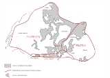
The Silverpit crater
Silverpit crater
Silverpit crater is a buried sub-sea structure under the North Sea off the coast of the United Kingdom. The crater-like form, named after the Silver Pit — a nearby sea-floor valley recognized by generations of fishermen — was discovered during the routine analysis of seismic data collected during...
, a 20 kilometres (12.4 mi) diameter suspected impact crater in the North Sea
North Sea
In the southwest, beyond the Straits of Dover, the North Sea becomes the English Channel connecting to the Atlantic Ocean. In the east, it connects to the Baltic Sea via the Skagerrak and Kattegat, narrow straits that separate Denmark from Norway and Sweden respectively...
The age of the feature is constrained between 74 – 45 million years (Late Cretaceous
Cretaceous
The Cretaceous , derived from the Latin "creta" , usually abbreviated K for its German translation Kreide , is a geologic period and system from circa to million years ago. In the geologic timescale, the Cretaceous follows the Jurassic period and is followed by the Paleogene period of the...
– Eocene
Eocene
The Eocene Epoch, lasting from about 56 to 34 million years ago , is a major division of the geologic timescale and the second epoch of the Paleogene Period in the Cenozoic Era. The Eocene spans the time from the end of the Palaeocene Epoch to the beginning of the Oligocene Epoch. The start of the...
). The Sole Pit Basin was created by deep burial of depocentres.
Cenozoic era intracratonic basin formation
Cenozoic
The Cenozoic era is the current and most recent of the three Phanerozoic geological eras and covers the period from 65.5 mya to the present. The era began in the wake of the Cretaceous–Tertiary extinction event at the end of the Cretaceous that saw the demise of the last non-avian dinosaurs and...
era covers the period from 65.5 Ma and is still ongoing. It comprises the Quaternary
Quaternary
The Quaternary Period is the most recent of the three periods of the Cenozoic Era in the geologic time scale of the ICS. It follows the Neogene Period, spanning 2.588 ± 0.005 million years ago to the present...
, the Paleogene
Paleogene
The Paleogene is a geologic period and system that began 65.5 ± 0.3 and ended 23.03 ± 0.05 million years ago and comprises the first part of the Cenozoic Era...
and Neogene
Neogene
The Neogene is a geologic period and system in the International Commission on Stratigraphy Geologic Timescale starting 23.03 ± 0.05 million years ago and ending 2.588 million years ago...
periods. Geologically
Geology
Geology is the science comprising the study of solid Earth, the rocks of which it is composed, and the processes by which it evolves. Geology gives insight into the history of the Earth, as it provides the primary evidence for plate tectonics, the evolutionary history of life, and past climates...
, the Cenozoic is the era when the continent
Continent
A continent is one of several very large landmasses on Earth. They are generally identified by convention rather than any strict criteria, with seven regions commonly regarded as continents—they are : Asia, Africa, North America, South America, Antarctica, Europe, and Australia.Plate tectonics is...
s moved into their current positions. The Alpine Orogeny
Alpine orogeny
The Alpine orogeny is an orogenic phase in the Late Mesozoic and Tertiary that formed the mountain ranges of the Alpide belt...
, the spreading of the Mid Atlantic ridge, and the creation of the Atlantic Ocean basin occurred in the Cenozoic era. The Iceland hot spot and North Atlantic rifting helped to exhume the British Isles. In the early Palaeogene period (Caenozoic Era) between 63 and 52 Ma, the North Sea
North Sea
In the southwest, beyond the Straits of Dover, the North Sea becomes the English Channel connecting to the Atlantic Ocean. In the east, it connects to the Baltic Sea via the Skagerrak and Kattegat, narrow straits that separate Denmark from Norway and Sweden respectively...
formed, and Britain was uplift
Tectonic uplift
Tectonic uplift is a geological process most often caused by plate tectonics which increases elevation. The opposite of uplift is subsidence, which results in a decrease in elevation. Uplift may be orogenic or isostatic.-Orogenic uplift:...
ed. Some of this uplift was along old lines of weakness from the Caledonian and Variscan Orogenies long before.
The post rift phase followed late Jurassic rift events during the late Mesozoic and Cenozoic thermal subsidence
Thermal subsidence
In geology and geophysics, thermal subsidence is a mechanism of subsidence in which conductive cooling of the mantle thickens the lithosphere and causes it to decrease in elevation. This is because of thermal contraction: as mantle material cools and becomes part of the mechanically-rigid...
. As the rifting stopped, then regional subsidence occurred creating an intracratonic
Craton
A craton is an old and stable part of the continental lithosphere. Having often survived cycles of merging and rifting of continents, cratons are generally found in the interiors of tectonic plates. They are characteristically composed of ancient crystalline basement rock, which may be covered by...
sedimentary basin
Sedimentary basin
The term sedimentary basin is used to refer to any geographical feature exhibiting subsidence and consequent infilling by sedimentation. As the sediments are buried, they are subjected to increasing pressure and begin the process of lithification...
. Subsidence occurred due to lithosphere
Lithosphere
The lithosphere is the rigid outermost shell of a rocky planet. On Earth, it comprises the crust and the portion of the upper mantle that behaves elastically on time scales of thousands of years or greater.- Earth's lithosphere :...
cooling. Some of this uplift was along old lines of weakness from the Caledonian
Caledonian orogeny
The Caledonian orogeny is a mountain building era recorded in the northern parts of the British Isles, the Scandinavian Mountains, Svalbard, eastern Greenland and parts of north-central Europe. The Caledonian orogeny encompasses events that occurred from the Ordovician to Early Devonian, roughly...
and Variscan Orogenies
Variscan orogeny
The Variscan orogeny is a geologic mountain-building event caused by Late Paleozoic continental collision between Euramerica and Gondwana to form the supercontinent of Pangaea.-Naming:...
long before. Intraplate compression was caused when the Atlantic Ocean basin formed. the Mid-Atlantic spreading ridge has been busy separating east from west. Greenland
Greenland
Greenland is an autonomous country within the Kingdom of Denmark, located between the Arctic and Atlantic Oceans, east of the Canadian Arctic Archipelago. Though physiographically a part of the continent of North America, Greenland has been politically and culturally associated with Europe for...
separated from North America
North America
North America is a continent wholly within the Northern Hemisphere and almost wholly within the Western Hemisphere. It is also considered a northern subcontinent of the Americas...
and the rifting altered direction during the Paleogene
Paleogene
The Paleogene is a geologic period and system that began 65.5 ± 0.3 and ended 23.03 ± 0.05 million years ago and comprises the first part of the Cenozoic Era...
, which caused Northern Europe to separate from Greenland
Greenland
Greenland is an autonomous country within the Kingdom of Denmark, located between the Arctic and Atlantic Oceans, east of the Canadian Arctic Archipelago. Though physiographically a part of the continent of North America, Greenland has been politically and culturally associated with Europe for...
. During the Eocene
Eocene
The Eocene Epoch, lasting from about 56 to 34 million years ago , is a major division of the geologic timescale and the second epoch of the Paleogene Period in the Cenozoic Era. The Eocene spans the time from the end of the Palaeocene Epoch to the beginning of the Oligocene Epoch. The start of the...
period, the last land bridge
Land bridge
A land bridge, in biogeography, is an isthmus or wider land connection between otherwise separate areas, over which animals and plants are able to cross and colonise new lands...
across the Atlantic sank.
The Alpine Orogeny
Alpine orogeny
The Alpine orogeny is an orogenic phase in the Late Mesozoic and Tertiary that formed the mountain ranges of the Alpide belt...
that took place about 50 Ma was responsible for the shaping of the London Basin
London Basin
The London Basin is an elongated, roughly triangular sedimentary basin approximately long which underlies London and a large area of south east England, south eastern East Anglia and the adjacent North Sea...
syncline
Syncline
In structural geology, a syncline is a fold, with younger layers closer to the center of the structure. A synclinorium is a large syncline with superimposed smaller folds. Synclines are typically a downward fold, termed a synformal syncline In structural geology, a syncline is a fold, with younger...
and the Weald
Weald
The Weald is the name given to an area in South East England situated between the parallel chalk escarpments of the North and the South Downs. It should be regarded as three separate parts: the sandstone "High Weald" in the centre; the clay "Low Weald" periphery; and the Greensand Ridge which...
anticline
Anticline
In structural geology, an anticline is a fold that is convex up and has its oldest beds at its core. The term is not to be confused with antiform, which is a purely descriptive term for any fold that is convex up. Therefore if age relationships In structural geology, an anticline is a fold that is...
to the south. The eastern end of the London Basin merges with the basin of the North Sea
North Sea
In the southwest, beyond the Straits of Dover, the North Sea becomes the English Channel connecting to the Atlantic Ocean. In the east, it connects to the Baltic Sea via the Skagerrak and Kattegat, narrow straits that separate Denmark from Norway and Sweden respectively...
, extending on land along the north Kent
Kent
Kent is a county in southeast England, and is one of the home counties. It borders East Sussex, Surrey and Greater London and has a defined boundary with Essex in the middle of the Thames Estuary. The ceremonial county boundaries of Kent include the shire county of Kent and the unitary borough of...
coast to Reculver
Reculver
Reculver is a hamlet and coastal resort situated about east of Herne Bay in southeast England. It is a ward of the City of Canterbury district in the county of Kent. Reculver once occupied a strategic location at the western end of the Wantsum Channel, between the Isle of Thanet and the Kent...
and up the east coast of Essex
Essex
Essex is a ceremonial and non-metropolitan county in the East region of England, and one of the home counties. It is located to the northeast of Greater London. It borders with Cambridgeshire and Suffolk to the north, Hertfordshire to the west, Kent to the South and London to the south west...
and into Suffolk
Suffolk
Suffolk is a non-metropolitan county of historic origin in East Anglia, England. It has borders with Norfolk to the north, Cambridgeshire to the west and Essex to the south. The North Sea lies to the east...
, where it is overlain by Pleistocene
Pleistocene
The Pleistocene is the epoch from 2,588,000 to 11,700 years BP that spans the world's recent period of repeated glaciations. The name pleistocene is derived from the Greek and ....
'Crag' deposits which cover much of eastern Suffolk and Norfolk
Norfolk
Norfolk is a low-lying county in the East of England. It has borders with Lincolnshire to the west, Cambridgeshire to the west and southwest and Suffolk to the south. Its northern and eastern boundaries are the North Sea coast and to the north-west the county is bordered by The Wash. The county...
and are better considered as part of the North Sea basin.
In the Miocene
Miocene
The Miocene is a geological epoch of the Neogene Period and extends from about . The Miocene was named by Sir Charles Lyell. Its name comes from the Greek words and and means "less recent" because it has 18% fewer modern sea invertebrates than the Pliocene. The Miocene follows the Oligocene...
and Pliocene
Pliocene
The Pliocene Epoch is the period in the geologic timescale that extends from 5.332 million to 2.588 million years before present. It is the second and youngest epoch of the Neogene Period in the Cenozoic Era. The Pliocene follows the Miocene Epoch and is followed by the Pleistocene Epoch...
epochs of the Neogene
Neogene
The Neogene is a geologic period and system in the International Commission on Stratigraphy Geologic Timescale starting 23.03 ± 0.05 million years ago and ending 2.588 million years ago...
period, further uplift and erosion occurred, particularly in the Pennines. Plant and animal types developed into their modern forms, and by about 2 Ma the landscape would have been broadly recognisable today.
Ice Age
The PleistocenePleistocene
The Pleistocene is the epoch from 2,588,000 to 11,700 years BP that spans the world's recent period of repeated glaciations. The name pleistocene is derived from the Greek and ....
saw the sea retreat from the basin as global sea-level fell due to accumulation of ice sheets. The major changes during the Pleistocene
Pleistocene
The Pleistocene is the epoch from 2,588,000 to 11,700 years BP that spans the world's recent period of repeated glaciations. The name pleistocene is derived from the Greek and ....
epoch have been brought about by several recent ice age
Ice age
An ice age or, more precisely, glacial age, is a generic geological period of long-term reduction in the temperature of the Earth's surface and atmosphere, resulting in the presence or expansion of continental ice sheets, polar ice sheets and alpine glaciers...
s. During glaciation, water was taken from the oceans to form the ice at high latitudes, causing global sea level to drop by about 120 meters, exposing the continental shelves and forming land-bridges between land-masses for animals to migrate. During deglaciation, the melted ice-water returned to the oceans, causing sea level to rise. This process can cause sudden shifts in coastlines and hydration systems resulting in newly submerged lands, emerging lands, collapsed ice dam
Ice dam
An ice dam occurs when water builds up behind a blockage of ice. Ice dams can occur in various ways.-Caused by a glacier:Sometimes a glacier flows down a valley to a confluence where the other branch carries an unfrozen river...
s resulting in salination
Salinity
Salinity is the saltiness or dissolved salt content of a body of water. It is a general term used to describe the levels of different salts such as sodium chloride, magnesium and calcium sulfates, and bicarbonates...
of lakes, new ice dams creating vast areas of freshwater, and a general alteration in regional weather patterns on a large but temporary scale. It can even cause temporary reglaciation. This type of chaotic pattern of rapidly changing land, ice, saltwater and freshwater has been proposed as the likely model for the Baltic and Scandinavian regions, as well as much of central North America at the end of the last glacial maximum
Last Glacial Maximum
The Last Glacial Maximum refers to a period in the Earth's climate history when ice sheets were at their maximum extension, between 26,500 and 19,000–20,000 years ago, marking the peak of the last glacial period. During this time, vast ice sheets covered much of North America, northern Europe and...
LGM, with the present-day coastlines only being achieved in the last few millennia of prehistory. Also, the effect of elevation on Scandinavia submerged a vast continental plain that had existed under much of what is now the North Sea, connecting the British Isles to Continental Europe.
At one time there was land where the strait is now, a south-east extension of the Weald
Weald
The Weald is the name given to an area in South East England situated between the parallel chalk escarpments of the North and the South Downs. It should be regarded as three separate parts: the sandstone "High Weald" in the centre; the clay "Low Weald" periphery; and the Greensand Ridge which...
joining what is now Great Britain
Great Britain
Great Britain or Britain is an island situated to the northwest of Continental Europe. It is the ninth largest island in the world, and the largest European island, as well as the largest of the British Isles...
to continental Europe
Continental Europe
Continental Europe, also referred to as mainland Europe or simply the Continent, is the continent of Europe, explicitly excluding European islands....
. The Strait of Dover opened during the Ice Age, as described below; as a result the British Isles have now become islands not connected with continental Europe any longer. The English Channel was formed by erosion caused by two major floods. The first was about 425,000 years ago, when an ice-dammed lake in the southern North Sea overflowed and broke the Weald-Artois
Artois
Artois is a former province of northern France. Its territory has an area of around 4000 km² and a population of about one million. Its principal cities are Arras , Saint-Omer, Lens and Béthune.-Location:...
chalk range in a catastrophic erosion and flood event. Afterwards, the Thames and Scheldt
Scheldt
The Scheldt is a 350 km long river in northern France, western Belgium and the southwestern part of the Netherlands...
flowed through the gap into the English Channel, but the Meuse
Meuse River
The Maas or Meuse is a major European river, rising in France and flowing through Belgium and the Netherlands before draining into the North Sea...
and Rhine still flowed northwards. In a second flood about 225,000 years ago the Meuse and Rhine were ice-dammed into a lake that broke catastrophically through a high weak barrier (perhaps chalk, or end-moraines left by the ice sheet). Both floods cut massive flood channels in the dry bed of the English Channel
English Channel
The English Channel , often referred to simply as the Channel, is an arm of the Atlantic Ocean that separates southern England from northern France, and joins the North Sea to the Atlantic. It is about long and varies in width from at its widest to in the Strait of Dover...
, somewhat like the Channeled Scablands
Channeled scablands
The Channeled Scablands are a unique geological erosion feature in the U.S. state of Washington. They were created by the cataclysmic Missoula Floods that swept periodically across eastern Washington and down the Columbia River Plateau during the Pleistocene epoch. Geologist J Harlen Bretz coined...
in the USA.
Glaciation had an enormous impact on the coastline of the North Sea. The west coast of Denmark is notable as it had been very glaciated during the Saale Glacial Stage and Weichsel glaciation. As the sea levels fell in the Holocene
Holocene
The Holocene is a geological epoch which began at the end of the Pleistocene and continues to the present. The Holocene is part of the Quaternary period. Its name comes from the Greek words and , meaning "entirely recent"...
epoch, Denmark's north coast gave way to raised spits, beach ridges and cliffs.
During the glacial maximum
Last Glacial Maximum
The Last Glacial Maximum refers to a period in the Earth's climate history when ice sheets were at their maximum extension, between 26,500 and 19,000–20,000 years ago, marking the peak of the last glacial period. During this time, vast ice sheets covered much of North America, northern Europe and...
in Scandinavia regionally referred to as the Weichsel glaciation, only the western parts of Jutland
Jutland
Jutland , historically also called Cimbria, is the name of the peninsula that juts out in Northern Europe toward the rest of Scandinavia, forming the mainland part of Denmark. It has the North Sea to its west, Kattegat and Skagerrak to its north, the Baltic Sea to its east, and the Danish–German...
were ice-free, and a large part of what is today the North Sea
North Sea
In the southwest, beyond the Straits of Dover, the North Sea becomes the English Channel connecting to the Atlantic Ocean. In the east, it connects to the Baltic Sea via the Skagerrak and Kattegat, narrow straits that separate Denmark from Norway and Sweden respectively...
was dry land connecting Jutland with Britain. It is also in Denmark that the only Scandinavian ice-age animals older than 13,000 BC are found. In the period following the last interglacial
Interglacial
An Interglacial period is a geological interval of warmer global average temperature lasting thousands of years that separates consecutive glacial periods within an ice age...
before the current one (Eemian Stage), the coast of Norway
Norway
Norway , officially the Kingdom of Norway, is a Nordic unitary constitutional monarchy whose territory comprises the western portion of the Scandinavian Peninsula, Jan Mayen, and the Arctic archipelago of Svalbard and Bouvet Island. Norway has a total area of and a population of about 4.9 million...
was also ice-free. The Baltic Sea
Baltic Sea
The Baltic Sea is a brackish mediterranean sea located in Northern Europe, from 53°N to 66°N latitude and from 20°E to 26°E longitude. It is bounded by the Scandinavian Peninsula, the mainland of Europe, and the Danish islands. It drains into the Kattegat by way of the Øresund, the Great Belt and...
, with its unique brackish water
Brackish water
Brackish water is water that has more salinity than fresh water, but not as much as seawater. It may result from mixing of seawater with fresh water, as in estuaries, or it may occur in brackish fossil aquifers. The word comes from the Middle Dutch root "brak," meaning "salty"...
, is a result of meltwater from the Weichsel glaciation combining with saltwater from the North Sea when the straits between Sweden and Denmark opened. The North Sea produces fossils from every period of the Pleistocene. The area was a dry steppe
Steppe
In physical geography, steppe is an ecoregion, in the montane grasslands and shrublands and temperate grasslands, savannas, and shrublands biomes, characterized by grassland plains without trees apart from those near rivers and lakes...
landscape, overlain with rivers, where animals such as the elephant-like mastodon, scimitar cat, southern mammoth, hippopotamus, horses, bears and giant deer lived. They were flooded at the close of the last Ice Age.
Maps
http://upload.wikimedia.org/wikipedia/commons/e/e4/Avalonia_entwicklung_odovizium_silur.png- http://upload.wikimedia.org/wikipedia/commons/e/e4/Avalonia_entwicklung_odovizium_silur.png These maps show the relative positions of the terranes and continental plates at various stages in the Ordovician, Silurian and Devonian respectively. The names shown are in their German forms.
- http://commons.wikimedia.org/wiki/Image:AVALONIA.jpg This map shows the collision of AvaloniaAvaloniaAvalonia was a microcontinent in the Paleozoic era. Crustal fragments of this former microcontinent underlie south-west Great Britain, and the eastern coast of North America. It is the source of many of the older rocks of Western Europe, Atlantic Canada, and parts of the coastal United States...
, BalticaBalticaBaltica is a name applied by geologists to a late-Proterozoic, early-Palaeozoic continent that now includes the East European craton of northwestern Eurasia. Baltica was created as an entity not earlier than 1.8 billion years ago. Before this time, the three segments/continents that now comprise...
and LaurentiaLaurentiaLaurentia is a large area of continental craton, which forms the ancient geological core of the North American continent...
. The names are shown in French. - http://commons.wikimedia.org/wiki/Image:RHAETIC_EARTH.jpg This map shows the rifting zones in the Triassic period. The names shown are in Italian.
- http://commons.wikimedia.org/wiki/Image:Gliederung_der_Varisziden_in_Mitteleuropa.jpg This map shows transformation of a magmatic arc and an orogenic root during oblique collision; the precollisional subduction erosion in ancient collisional belts: The case of the Mid-European Variscides. The names shown are in their German forms.
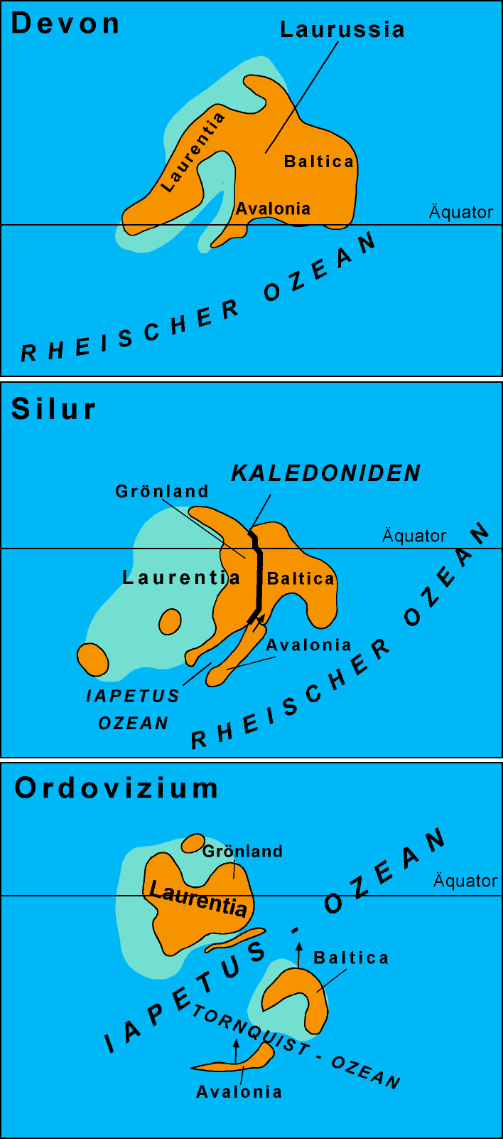
See also
- Armorican MassifArmorican MassifThe Armorican Massif is a geologic massif that covers a large area in the northwest of France, including Brittany, the western part of Normandy and the Pays de la Loire. Its name comes from the old Armorica, a Gaul area between the Loire and the Seine rivers...
- Chalk Group
- Conglomerate, Fanglomerate of the North SeaConglomerate (geology)A conglomerate is a rock consisting of individual clasts within a finer-grained matrix that have become cemented together. Conglomerates are sedimentary rocks consisting of rounded fragments and are thus differentiated from breccias, which consist of angular clasts...
- CretaceousCretaceousThe Cretaceous , derived from the Latin "creta" , usually abbreviated K for its German translation Kreide , is a geologic period and system from circa to million years ago. In the geologic timescale, the Cretaceous follows the Jurassic period and is followed by the Paleogene period of the...
- Chalk rock formations. - Cretaceous–Tertiary extinction event
- Geologic time scaleGeologic time scaleThe geologic time scale provides a system of chronologic measurement relating stratigraphy to time that is used by geologists, paleontologists and other earth scientists to describe the timing and relationships between events that have occurred during the history of the Earth...
- Geology of the British IslesGeology of the British IslesGreat Britain shows a rich variety of landscape across the constituent countries of England, Wales and Scotland. Landforms and rocks of all geological ages are represented, from Precambrian onwards.- Seismographical results :...
- Geology of Ireland
- Geology of ScotlandGeology of ScotlandThe geology of Scotland is unusually varied for a country of its size, with a large number of differing geological features. There are three main geographical sub-divisions: the Highlands and Islands is a diverse area which lies to the north and west of the Highland Boundary Fault; the Central...
- Geology of WalesGeology of WalesWales is a peninsula in the south-west of the island of Great Britain. The entire area of Wales is about . It is about north-south and east-west. Wales is bordered by England to the east and by sea in the other three directions: the Bristol Channel to the south, St George's Channel to the west,...
- Geology of the NetherlandsGeology of the NetherlandsThe geology of the Netherlands describes the geological sequence of the Netherlands. Large parts of the Netherlands today are below sea level and have in the past been covered by the sea or flooded at regular intervals. The modern Netherlands formed as a result of the interplay of the four main...
- Geology of NorwayGeology of NorwayThe geology of Norway encompasses the history of earth that can be interpreted by rock types found in Norway, and the associated sedimentological history of soils and rock types....
- Giessen nappeGiessen nappeThe Giessen nappe is a tectonic nappe in the southeastern part of the Rhenish Massif in western Germany. The nappe is an "alien" unit in the Rhenohercynian zone of the Hercynian orogeny, it was thrusted over the usual slightly metamorphosed Devonian and Carboniferous sedimentary rocks in this...
- Glacial lake outburst flood - England / France
- Great Glen FaultGreat Glen FaultThe Great Glen Fault is a long strike-slip fault that runs through its namesake the Great Glen in Scotland. However, the fault is actually much longer and over 400 million years old.-Location:...
- Highland Boundary FaultHighland Boundary FaultThe Highland Boundary Fault is a geological fault that traverses Scotland from Arran and Helensburgh on the west coast to Stonehaven in the east...
- London BasinLondon BasinThe London Basin is an elongated, roughly triangular sedimentary basin approximately long which underlies London and a large area of south east England, south eastern East Anglia and the adjacent North Sea...
- London-Brabant Massif
- Old Red SandstoneOld Red SandstoneThe Old Red Sandstone is a British rock formation of considerable importance to early paleontology. For convenience the short version of the term, 'ORS' is often used in literature on the subject.-Sedimentology:...
- Oslo GrabenOslo GrabenThe Oslo Graben or Oslo Rift is a graben formed during a geologic rifting event in Permian time, the last phase of the Variscan orogeny. The main graben forming period began in the late Carboniferous, which culminated with rift formation and volcanism, with associated rhomb porphyry lava flows...
- Rhenish Massif
- Saxothuringian ZoneSaxothuringian ZoneThe Saxothuringian Zone or Saxothuringicum is in geology a structural or tectonic zone in the Hercynian or Variscan orogen of central and western Europe. Because rocks of Hercynian age are in most places covered by younger strata, the zone is not everywhere visible at the surface...
- Sedimentary basinSedimentary basinThe term sedimentary basin is used to refer to any geographical feature exhibiting subsidence and consequent infilling by sedimentation. As the sediments are buried, they are subjected to increasing pressure and begin the process of lithification...
- basin caused by lithospheric stretching - Silverpit craterSilverpit craterSilverpit crater is a buried sub-sea structure under the North Sea off the coast of the United Kingdom. The crater-like form, named after the Silver Pit — a nearby sea-floor valley recognized by generations of fishermen — was discovered during the routine analysis of seismic data collected during...
Footnotes
- Gillen, Con (2003) Geology and landscapes of Scotland. Harpenden. Terra Publishing.; 2001: The Variscan collage and orogeny (480-290 Ma) and the tectonic definition of the Armorica microplate: a review, Terra Nova 13, 122-128.
- McKirdy, Alan Gordon, John & Crofts, Roger (2007) Land of Mountain and Flood: The Geology and Landforms of Scotland. Edinburgh. Birlinn.; 2002: Paleozoic evolution of pre-Variscan terranes: From Gondwana to the Variscan collision, Geological Society of AmericaGeological Society of AmericaThe Geological Society of America is a nonprofit organization dedicated to the advancement of the geosciences. The society was founded in New York in 1888 by Alexander Winchell, John J. Stevenson, Charles H. Hitchcock, John R. Proctor and Edward Orton and has been headquartered at 3300 Penrose...
Special Paper 364, pp. 263–280.http://www.unil.ch/webdav/site/mcg/users/gborel/public/Peri-Gond_GSA.pdf - Stanley, Steven M. Earth System History. New York: W.H. Freeman and Company, 1999. ISBN 0-7167-2882-6; 1996: Continental break-up and collision in the Neoproterozoic and Palaeozoic - A tale of Baltica and Laurentia, Earth-Science Reviews 40, p. 229-258.; 1996: The Evolving Continents, John Wiley & Sons (3rd ed.), ISBN 0471917397.; 1990: Geological Atlas of Western and Central Europe, Shell Internationale Petroleum Maatschappij BVRoyal Dutch ShellRoyal Dutch Shell plc , commonly known as Shell, is a global oil and gas company headquartered in The Hague, Netherlands and with its registered office in London, United Kingdom. It is the fifth-largest company in the world according to a composite measure by Forbes magazine and one of the six...
(2nd ed.), ISBN 90-6644-125-9.
External sources
- The Millennium Atlas: Petroleum geology of the central and northern North Sea by Dan Evans, Colin Graham and Heather Stewart. Publisher: Geological Society Publishing House; New Ed edition (31 Jan 2003). ISBN 186239119X ISBN 978-1862391192.