

Weald
Encyclopedia
South East England
South East England is one of the nine official regions of England, designated in 1994 and adopted for statistical purposes in 1999. It consists of Berkshire, Buckinghamshire, East Sussex, Hampshire, Isle of Wight, Kent, Oxfordshire, Surrey and West Sussex...
situated between the parallel chalk
Chalk
Chalk is a soft, white, porous sedimentary rock, a form of limestone composed of the mineral calcite. Calcite is calcium carbonate or CaCO3. It forms under reasonably deep marine conditions from the gradual accumulation of minute calcite plates shed from micro-organisms called coccolithophores....
escarpment
Escarpment
An escarpment is a steep slope or long cliff that occurs from erosion or faulting and separates two relatively level areas of differing elevations.-Description and variants:...
s of the North
North Downs
The North Downs are a ridge of chalk hills in south east England that stretch from Farnham in Surrey to the White Cliffs of Dover in Kent. The North Downs lie within two Areas of Outstanding Natural Beauty , the Surrey Hills and the Kent Downs...
and the South Downs
South Downs
The South Downs is a range of chalk hills that extends for about across the south-eastern coastal counties of England from the Itchen Valley of Hampshire in the west to Beachy Head, near Eastbourne, East Sussex, in the east. It is bounded on its northern side by a steep escarpment, from whose...
. It should be regarded as three separate parts: the sandstone
Sandstone
Sandstone is a sedimentary rock composed mainly of sand-sized minerals or rock grains.Most sandstone is composed of quartz and/or feldspar because these are the most common minerals in the Earth's crust. Like sand, sandstone may be any colour, but the most common colours are tan, brown, yellow,...
"High Weald" in the centre; the clay
Clay
Clay is a general term including many combinations of one or more clay minerals with traces of metal oxides and organic matter. Geologic clay deposits are mostly composed of phyllosilicate minerals containing variable amounts of water trapped in the mineral structure.- Formation :Clay minerals...
"Low Weald" periphery; and the Greensand Ridge
Greensand Ridge
The Greensand Ridge is an extensive, prominent, often heavily wooded, sandstone escarpment and range of hills in south-east England. It runs in a horseshoe shape around the Weald of Surrey, Sussex and Kent. It reaches its highest elevation, , at Leith Hill in Surrey—the second highest point...
which stretches around the north and west of the Weald and includes the Weald's highest points. The Weald was once a vast forest covering this area. The name, Old English
Anglo-Saxons
Anglo-Saxon is a term used by historians to designate the Germanic tribes who invaded and settled the south and east of Great Britain beginning in the early 5th century AD, and the period from their creation of the English nation to the Norman conquest. The Anglo-Saxon Era denotes the period of...
in origin, signifies woodland, which still applies today: scattered farms and villages betray the Weald‘s past, often in their names.
Etymology
The name "Weald" is derived from the Old English , meaning "forest" (cognate, German Wald). This comes from a Germanic root of the same meaning, and ultimately from Indo-EuropeanIndo-European
Indo-European may refer to:* Indo-European languages** Aryan race, a 19th century and early 20th century term for those peoples who are the native speakers of Indo-European languages...
. Weald is a specifically a West Saxon form; wold
Wold
Wold may refer to :Geography*The Wolds, a term used in England to describe a range of hills consisting of open country overlying limestone or chalk *The former name of the village of Old, Northamptonshire, EnglandPeople...
is the Anglian form of the word. The Middle English
Middle English
Middle English is the stage in the history of the English language during the High and Late Middle Ages, or roughly during the four centuries between the late 11th and the late 15th century....
form of the word is wēld, and the modern spelling is a reintroduction of the Anglo-Saxon form attributed to its use by William Lambarde
William Lambarde
William Lambarde was an antiquarian and writer on legal subjects.-Life:Lambarde was born in London. His father was a draper , an alderman and a sheriff of London. In 1556, he was admitted to Lincoln's Inn...
in his A Perambulation of Kent of 1576.
In the Anglo-Saxon
Anglo-Saxon
Anglo-Saxon may refer to:* Anglo-Saxons, a group that invaded Britain** Old English, their language** Anglo-Saxon England, their history, one of various ships* White Anglo-Saxon Protestant, an ethnicity* Anglo-Saxon economy, modern macroeconomic term...
period the area had the name Andredes weald, meaning "the forest of Andred", the latter derived from the Roman name of Pevensey
Pevensey
Pevensey is a village and civil parish in the Wealden district of East Sussex, England. The main village is located 5 miles north-east of Eastbourne, one mile inland from Pevensey Bay. The settlement of Pevensey Bay forms part of the parish.-Geography:The village of Pevensey is located on...
, Anderida. The area is also referred to in Anglo-Saxon texts as Andredesleage, where the second element is another Old English word for "woodland", represented by modern Leigh.
The adjective for "weald" is "wealden".
Geology
See also, Geology of East SussexGeology of East Sussex
The Geology of East Sussex is defined by the Weald–Artois anticline, a wide and long fold within which caused the arching up of the chalk into a broad dome within the middle Miocene, which has subsequently been eroded down to reveal a lower Cretaceous to Upper Jurassic Stratigraphy...
, Weald basin
Weald Basin
The Weald Basin was a major topographic feature of southern England and northern France from the Triassic to the late Cretaceous, its uplift in the late Cretaceous marked the formation of the Wealden Anticline....
and Weald–Artois anticline
Anticline
In structural geology, an anticline is a fold that is convex up and has its oldest beds at its core. The term is not to be confused with antiform, which is a purely descriptive term for any fold that is convex up. Therefore if age relationships In structural geology, an anticline is a fold that is...
, a dome of layered Lower Cretaceous rock
Rock (geology)
In geology, rock or stone is a naturally occurring solid aggregate of minerals and/or mineraloids.The Earth's outer solid layer, the lithosphere, is made of rock. In general rocks are of three types, namely, igneous, sedimentary, and metamorphic...
s cut through by weathering
Weathering
Weathering is the breaking down of rocks, soils and minerals as well as artificial materials through contact with the Earth's atmosphere, biota and waters...
to expose the layers as sandstone
Sandstone
Sandstone is a sedimentary rock composed mainly of sand-sized minerals or rock grains.Most sandstone is composed of quartz and/or feldspar because these are the most common minerals in the Earth's crust. Like sand, sandstone may be any colour, but the most common colours are tan, brown, yellow,...
ridges and clay
Clay
Clay is a general term including many combinations of one or more clay minerals with traces of metal oxides and organic matter. Geologic clay deposits are mostly composed of phyllosilicate minerals containing variable amounts of water trapped in the mineral structure.- Formation :Clay minerals...
valleys. The oldest rocks exposed at the centre of the anticline are correlated with the Purbeck Beds of the Upper Jurassic. Above these, the Cretaceous rocks, include the Wealden Group
Wealden Group
The Wealden Group is a group in the lithostratigraphy of southern England. The Wealden group consists of paralic to continental facies sedimentary rocks of Valanginian to Barremian age and thus forms part of the English Lower Cretaceous. It is composed of alternating sands and clays...
of alternating sands and clays - the Ashdown Sand, Wadhurst Clay, Tunbridge Wells Sand (collectively known as the Hastings Beds) and the Weald Clay. The Wealden Group is overlain by the Lower Greensand and the Gault Formation, consisting of the Gault Clay
Gault Clay
Gault is a clay formation of stiff blue clay deposited in a calm, fairly deep water marine environment during the Lower Cretaceous Period...
and the Upper Greensand.
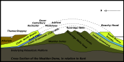
The rocks of the central part of the anticline include hard sandstones, and these form hills now called the High Weald. The peripheral areas are mostly of softer sandstones and clays and form a gentler rolling landscape, the Low Weald. The Weald-Artois Anticline
Weald-Artois Anticline
The Weald–Artois anticline is a large anticline, a geological structure running between the regions of the Weald in southern England and the Artois in northeastern France. The fold formed during the Alpine orogeny, from the late Oligocene to middle Miocene as an uplifted form of the Weald basin...
continues some 65 km (40.4 mi) further south-eastwards under the Straits of Dover, and includes the Boulonnais
Boulonnais (land area)
The Boulonnais is a coastal area of northern France, around Calais and Boulogne-sur-Mer. It has a curved belt of chalk downs which run into the sea at both ends, and geologically is the east end of the Weald-Artois Anticline.- Administration :...
of France
France
The French Republic , The French Republic , The French Republic , (commonly known as France , is a unitary semi-presidential republic in Western Europe with several overseas territories and islands located on other continents and in the Indian, Pacific, and Atlantic oceans. Metropolitan France...
.
Many important fossils have been found in the sandstones and clays of the Weald, including, for example, Baryonyx
Baryonyx
Baryonyx is a genus of carnivorous saurischian dinosaur first discovered in clay pits just south of Dorking, England, and later reported from fossils found in northern Spain and Portugal. It is known to contain only one species, Baryonyx walkeri...
. The famous scientific hoax of Piltdown Man
Piltdown Man
The Piltdown Man was a hoax in which bone fragments were presented as the fossilised remains of a previously unknown early human. These fragments consisted of parts of a skull and jawbone, said to have been collected in 1912 from a gravel pit at Piltdown, East Sussex, England...
was claimed to have come from a gravel pit at Piltdown near Uckfield
Uckfield
-Development:The local Tesco has proposed the redevelopment of the central town area as has the town council. The Hub has recently been completed, having been acquired for an unknown figure, presumed to be about half a million pounds...
. The first Iguanodon
Iguanodon
Iguanodon is a genus of ornithopod dinosaur that lived roughly halfway between the first of the swift bipedal hypsilophodontids and the ornithopods' culmination in the duck-billed dinosaurs...
was identified by Gideon Mantell
Gideon Mantell
Gideon Algernon Mantell MRCS FRS was an English obstetrician, geologist and palaeontologist...
, from a fossil discovered in a pit near Cuckfield in 1819.
History
- Some of the following notes in the early part of this section are taken from the High Weald website.
Prehistoric evidence suggests that, following after the Mesolithic
Mesolithic
The Mesolithic is an archaeological concept used to refer to certain groups of archaeological cultures defined as falling between the Paleolithic and the Neolithic....
hunter-gatherers, the Neolithic
Neolithic
The Neolithic Age, Era, or Period, or New Stone Age, was a period in the development of human technology, beginning about 9500 BC in some parts of the Middle East, and later in other parts of the world. It is traditionally considered as the last part of the Stone Age...
inhabitants had turned to farming, with the resultant clearance of the forest. With the Iron Age
Iron Age
The Iron Age is the archaeological period generally occurring after the Bronze Age, marked by the prevalent use of iron. The early period of the age is characterized by the widespread use of iron or steel. The adoption of such material coincided with other changes in society, including differing...
came the first use of the Weald as an industrial area. Wealden sandstones contain ironstone
Ironstone
Ironstone is a sedimentary rock, either deposited directly as a ferruginous sediment or created by chemical repacement, that contains a substantial proportion of an iron compound from which iron either can be or once was smelted commercially. This term is customarily restricted to hard coarsely...
, and with the additional presence of large amounts of timber for making charcoal
Charcoal
Charcoal is the dark grey residue consisting of carbon, and any remaining ash, obtained by removing water and other volatile constituents from animal and vegetation substances. Charcoal is usually produced by slow pyrolysis, the heating of wood or other substances in the absence of oxygen...
for fuel, the area was the centre of the Wealden iron industry
Wealden iron industry
The Wealden iron industry was located in the Weald of south-eastern England. It was formerly an important industry, producing a large proportion of the bar iron made in England in the 16th century and most British cannon until about 1770. Ironmaking in the Weald used ironstone from various clay...
from then, through the Roman times
Roman Britain
Roman Britain was the part of the island of Great Britain controlled by the Roman Empire from AD 43 until ca. AD 410.The Romans referred to the imperial province as Britannia, which eventually comprised all of the island of Great Britain south of the fluid frontier with Caledonia...
, until the last forge was closed in 1813. The index to the Ordnance Survey Map of Roman Britain lists 33 iron mines; 67 per cent of these are in the Weald.
The entire Weald was originally heavily forested. According to the ninth century Anglo Saxon Chronicle, the Weald measured 120 mi (193 km) or longer by 30 mi (48 km) in the Saxon era, stretching from Lympne
Lympne
Lympne is a village situated on the former sea cliffs above the Romney Marsh in Kent. It lies approximately west of Folkestone, 2 miles west of Hythe and east of Ashford....
, near Romney Marsh
Romney Marsh
Romney Marsh is a sparsely populated wetland area in the counties of Kent and East Sussex in the south-east of England. It covers about 100 mi ² .-Quotations:*“As Egypt was the gift of the Nile, this level tract .....
in Kent, to the Forest of Bere
Forest of Bere
The Forest of Bere lies north of Fareham. A mixture of woodland, open space, ponds, streams, heathland, farmland and downland it provides countryside access to the residents of South-East Hampshire having a number of paths and bridleways for walking and cycling...
or even the New Forest
New Forest
The New Forest is an area of southern England which includes the largest remaining tracts of unenclosed pasture land, heathland and forest in the heavily-populated south east of England. It covers south-west Hampshire and extends into south-east Wiltshire....
in Hampshire. The area was sparsely inhabited and inhospitable, being used mainly as a resource by people living on its fringes, much as in other places in Britain such as Dartmoor
Dartmoor
Dartmoor is an area of moorland in south Devon, England. Protected by National Park status, it covers .The granite upland dates from the Carboniferous period of geological history. The moorland is capped with many exposed granite hilltops known as tors, providing habitats for Dartmoor wildlife. The...
, the Fens
The Fens
The Fens, also known as the , are a naturally marshy region in eastern England. Most of the fens were drained several centuries ago, resulting in a flat, damp, low-lying agricultural region....
and the Forest of Arden. The Weald was used for centuries, possibly since the Iron Age
Iron Age
The Iron Age is the archaeological period generally occurring after the Bronze Age, marked by the prevalent use of iron. The early period of the age is characterized by the widespread use of iron or steel. The adoption of such material coincided with other changes in society, including differing...
, for transhumance
Transhumance
Transhumance is the seasonal movement of people with their livestock between fixed summer and winter pastures. In montane regions it implies movement between higher pastures in summer and to lower valleys in winter. Herders have a permanent home, typically in valleys. Only the herds travel, with...
of animals along droveways in the summer months. Over the centuries deforestation for the shipbuilding, charcoal, forest glass
Forest glass
The term Forest glass or the German name Waldglas is given to late Medieval glass produced in North-Western Europe from about 1000-1700 AD using wood ash and sand as the main raw materials and made in factories known as glass-houses in forest areas...
, and brickmaking industries has left the Low Weald with only remnants of that woodland cover.
While most of the Weald was used for transhumance by communities at the edge of the Weald, several parts of the forest on the higher ridges in the interior seem to have been used for hunting by the kings of Sussex
Kingdom of Sussex
The Kingdom of Sussex or Kingdom of the South Saxons was a Saxon colony and later independent kingdom of the Saxons, on the south coast of England. Its boundaries coincided in general with those of the earlier kingdom of the Regnenses and the later county of Sussex. A large part of its territory...
. The pattern of droveways which occurs across the rest of the Weald is absent from these areas. These areas include St Leonard's Forest
St Leonard's Forest
St. Leonard's Forest is at the western end of the Wealden Forest Ridge which runs from Horsham to Tonbridge, and is part of the High Weald Area of Outstanding Natural Beauty. It lies on the ridge to the south of the A264 between Horsham and Crawley with the villages of Colgate and Lower Beeding...
, Worth Forest, Ashdown Forest
Ashdown Forest
Ashdown Forest is an ancient area of tranquil open heathland occupying the highest sandy ridge-top of the High Weald Area of Outstanding Natural Beauty. It is situated some south of London in the county of East Sussex, England...
and Dallington Forest
Dallington Forest
Dallington Forest is a 16.2 hectare biological Site of Special Scientific Interest, located in East Sussex, England. The site was notified in 1985 under the Wildlife and Countryside Act 1981, and is currently an area of ancient woodland....
.
The forests of the Weald were often used as a place of refuge and sanctuary. The Anglo-Saxon Chronicle
Anglo-Saxon Chronicle
The Anglo-Saxon Chronicle is a collection of annals in Old English chronicling the history of the Anglo-Saxons. The original manuscript of the Chronicle was created late in the 9th century, probably in Wessex, during the reign of Alfred the Great...
relates events during the Anglo-Saxon
Anglo-Saxon
Anglo-Saxon may refer to:* Anglo-Saxons, a group that invaded Britain** Old English, their language** Anglo-Saxon England, their history, one of various ships* White Anglo-Saxon Protestant, an ethnicity* Anglo-Saxon economy, modern macroeconomic term...
conquest of Sussex
Kingdom of Sussex
The Kingdom of Sussex or Kingdom of the South Saxons was a Saxon colony and later independent kingdom of the Saxons, on the south coast of England. Its boundaries coincided in general with those of the earlier kingdom of the Regnenses and the later county of Sussex. A large part of its territory...
when the native Britons (whom the Anglo-Saxons called Welsh
Welsh people
The Welsh people are an ethnic group and nation associated with Wales and the Welsh language.John Davies argues that the origin of the "Welsh nation" can be traced to the late 4th and early 5th centuries, following the Roman departure from Britain, although Brythonic Celtic languages seem to have...
) were driven from the coastal towns into the recesses of the forest for sanctuary, viz;
"A.D. 477. This year came Ælle to Britain, with his three sons, Cymen, and Wlenking, and CissaCissaCissa is a genus of relatively short-tailed magpies, though sometimes known as hunting cissas, that reside in the forests of tropical and subtropical southeast Asia and adjacent regions. The three species are quite similar with bright red bills, a mainly green plumage, black mask, and rufous wings...
, in three ships; landing at a place that is called CymenshoreCymenshoreCymenshore is the place in Southern England where according to the Anglo-Saxon Chronicle, Ælle of Sussex landed in 477 AD and battled the Welsh with his three sons Cymen, Wlencing and Cissa.-Historical context:The account of Ælle and his three sons landing at Cymenshore, in the Anglo Saxon...
. There they slew many of the Welsh; and some in flight they drove into the wood that is called Andred'sley."
Until the Late Middle Ages
Late Middle Ages
The Late Middle Ages was the period of European history generally comprising the 14th to the 16th century . The Late Middle Ages followed the High Middle Ages and preceded the onset of the early modern era ....
the forest was a notorious hiding place for bandits, highwaymen and outlaw
Outlaw
In historical legal systems, an outlaw is declared as outside the protection of the law. In pre-modern societies, this takes the burden of active prosecution of a criminal from the authorities. Instead, the criminal is withdrawn all legal protection, so that anyone is legally empowered to persecute...
s.
Settlements on the Weald are widely scattered. Villages evolved from small settlements in the woods, typically four to five miles apart; close enough to be an easy walk but not so close as to encourage unnecessary intrusion. Few of the settlements are mentioned in the Domesday Book
Domesday Book
Domesday Book , now held at The National Archives, Kew, Richmond upon Thames in South West London, is the record of the great survey of much of England and parts of Wales completed in 1086...
however Goudhurst's church dates from the early 12th Century or before and Wadhurst was of a sufficient size by the mid thirteenth century to be granted a royal charter permitting a market to be held. Before this time, the Weald was used as summer grazing land, particularly for pannage
Pannage
Pannage is the practice of turning out domestic pigs in a wood or forest, in order that they may feed on fallen acorns, beechmast, chestnuts or other nuts. Historically, it was a right or privilege granted to local people on common land or in royal forests...
by communities living in the surrounding areas. Many places within the Weald have retained names from this time, linking them to the original communities by the addition of the suffix "-den" – for example Tenterden
Tenterden
Tenterden is a Cinque Port town in the Ashford District of Kent, England. It stands on the edge of the Weald, overlooking the valley of the River Rother....
was the area used by the people of Thanet
Thanet
Thanet is a local government district of Kent, England which was formed under the Local Government Act 1972, and came into being on 1 April 1974...
. Permanent settlements in much of the Weald developed much later than in other parts of lowland Britain, although there were as many as one hundred furnaces and forges operating by the later 16th century, employing large numbers of people.
In his first published version of On The Origin of Species, Charles Darwin
Charles Darwin
Charles Robert Darwin FRS was an English naturalist. He established that all species of life have descended over time from common ancestry, and proposed the scientific theory that this branching pattern of evolution resulted from a process that he called natural selection.He published his theory...
used the chalk cliffs at Weald as a justification for his theory of natural selection. Charles Darwin was a follower of Lyell's theory of uniformitarianism
Uniformitarianism
In the philosophy of naturalism, the uniformitarianism assumption is that the same natural laws and processes that operate in the universe now, have always operated in the universe in the past and apply everywhere in the universe. It has included the gradualistic concept that "the present is the...
and decided to expand upon Lyell’s theory with a quantitative estimate to determine if there was enough time in the history of the earth to uphold his principles of evolution. He assumed that rate of erosion of the cliffs was around 1 inches (25.4 mm) per century and extrapolated the age of Weald at around 300 million years. In 1862, William Thomson (later appointed as Lord Kelvin) published a paper 'On the age of the sun's heat' in which, unaware of the process of solar fusion which had yet to be discovered, he calculated that the sun had been burning for less than a million years. Based on these estimates he denounced Darwin's geological estimates as imprecise. Darwin saw Lord Kelvin's calculation as one of the most serious criticisms to his theory and removed his calculations on the Weald from the third edition of On the Origin of Species.
Geography
The Weald in its entirety begins in the west to the north-east of PetersfieldPetersfield, Hampshire
Petersfield is a market town and civil parish in the East Hampshire district of Hampshire, England. It is north of Portsmouth, on the A3 road. The town has its own railway station on the Portsmouth Direct Line, the mainline rail link connecting Portsmouth and London. The town is situated on the...
in Hampshire
Hampshire
Hampshire is a county on the southern coast of England in the United Kingdom. The county town of Hampshire is Winchester, a historic cathedral city that was once the capital of England. Hampshire is notable for housing the original birthplaces of the Royal Navy, British Army, and Royal Air Force...
; from where it crosses the counties of Surrey
Surrey
Surrey is a county in the South East of England and is one of the Home Counties. The county borders Greater London, Kent, East Sussex, West Sussex, Hampshire and Berkshire. The historic county town is Guildford. Surrey County Council sits at Kingston upon Thames, although this has been part of...
and Kent
Kent
Kent is a county in southeast England, and is one of the home counties. It borders East Sussex, Surrey and Greater London and has a defined boundary with Essex in the middle of the Thames Estuary. The ceremonial county boundaries of Kent include the shire county of Kent and the unitary borough of...
in the north, and West
West Sussex
West Sussex is a county in the south of England, bordering onto East Sussex , Hampshire and Surrey. The county of Sussex has been divided into East and West since the 12th century, and obtained separate county councils in 1888, but it remained a single ceremonial county until 1974 and the coming...
and East Sussex
East Sussex
East Sussex is a county in South East England. It is bordered by the counties of Kent, Surrey and West Sussex, and to the south by the English Channel.-History:...
in the south. The western parts in Hampshire and West Sussex, known as the Western Weald
Western Weald
The western Weald is an area of undulating countryside in Hampshire and West Sussex containing a mixture of woodland and heathland areas.It lies to the south of the towns of Bordon, Haslemere and Rake and to the west of the town of Pulborough. It includes the towns of Liss and Petersfield on its...
, are included in the South Downs National Park
South Downs National Park
The South Downs National Park is England's newest National Park, having become fully operational on 1 April 2011. The park, covering an area of in southern England, stretches for from Winchester in the west to Eastbourne in the east through the counties of Hampshire, West Sussex and East Sussex...
. Other protected parts of the Weald are included in the Surrey Hills Area of Outstanding Natural Beauty
Surrey Hills AONB
The Surrey Hills is a Area of Outstanding Natural Beauty , located in Surrey, England. The AONB was designated in 1958 and covers one quarter of the county of Surrey...
and the High Weald Area of Outstanding Natural Beauty
High Weald AONB
The High Weald Area of Outstanding Natural Beauty is situated in south-east England. Covering an area of , it extends across the counties of Surrey, West Sussex, East Sussex and Kent. It is the fourth largest Area of Outstanding Beauty in England and Wales...
. In extent it covers about 85 miles (136.8 km) from west to east, and about 30 miles (48.3 km) from north to south, covering an area of some 1300 km² (501.9 sq mi). The eastern end of the High Weald, the English Channel
English Channel
The English Channel , often referred to simply as the Channel, is an arm of the Atlantic Ocean that separates southern England from northern France, and joins the North Sea to the Atlantic. It is about long and varies in width from at its widest to in the Strait of Dover...
coast, is marked in the centre by the high sandstone cliffs from Hastings
Hastings
Hastings is a town and borough in the county of East Sussex on the south coast of England. The town is located east of the county town of Lewes and south east of London, and has an estimated population of 86,900....
to Pett Level; and by former sea cliffs now fronted by the Pevensey and Romney Marshes on either side.
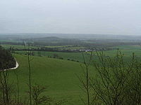
Much of the High Weald, the central part, is designated as the High Weald Area of Outstanding Natural Beauty. Its landscape is described as one of rolling hills, studded with sandstone outcrops and cut by streams to form steep-sided ravines (called gills); small irregular-shaped fields and patches of heathland, abundant woodlands; scattered farmsteads and sunken lanes and paths. Ashdown Forest, an extensive area of heathland and woodland occupying the highest sandy ridge-top at the centre of the High Weald, is a former royal deer-hunting forest created by the Normans and said to be the largest remaining part of Andredesweald.
There are centres of settlement, the largest of which are Horsham
Horsham
Horsham is a market town with a population of 55,657 on the upper reaches of the River Arun in the centre of the Weald, West Sussex, in the historic County of Sussex, England. The town is south south-west of London, north-west of Brighton and north-east of the county town of Chichester...
, Burgess Hill
Burgess Hill
Burgess Hill is a civil parish and a town primarily located in the Mid Sussex district of West Sussex, England, close to the border with East Sussex, on the edge of the South Downs National Park...
, East Grinstead
East Grinstead
East Grinstead is a town and civil parish in the northeastern corner of Mid Sussex, West Sussex in England near the East Sussex, Surrey, and Kent borders. It lies south of London, north northeast of Brighton, and east northeast of the county town of Chichester...
, Haywards Heath
Haywards Heath
-Climate:Haywards Heath experiences an oceanic climate similar to almost all of the United Kingdom.-Rail:Haywards Heath railway station is a major station on the Brighton Main Line...
, Tonbridge
Tonbridge
Tonbridge is a market town in the English county of Kent, with a population of 30,340 in 2007. It is located on the River Medway, approximately 4 miles north of Tunbridge Wells, 12 miles south west of Maidstone and 29 miles south east of London...
, Tunbridge Wells
Royal Tunbridge Wells
Royal Tunbridge Wells is a town in west Kent, England, about south-east of central London by road, by rail. The town is close to the border of the county of East Sussex...
, Crowborough
Crowborough
The highest point in the town is 242 metres above sea level. This summit is the highest point of the High Weald and second highest point in East Sussex . Its relative height is 159 m, meaning Crowborough qualifies as one of England's Marilyns...
; and the area along the coast from Hastings and Bexhill-on-Sea
Bexhill-on-Sea
Bexhill-on-Sea is a town and seaside resort in the county of East Sussex, in the south of England, within the District of Rother. It has a population of approximately 40,000...
to Rye
Rye, East Sussex
Rye is a small town in East Sussex, England, which stands approximately two miles from the open sea and is at the confluence of three rivers: the Rother, the Tillingham and the Brede...
and Hythe
Hythe, Kent
Hythe , is a small coastal market town on the edge of Romney Marsh, in the District of Shepway on the south coast of Kent. The word Hythe or Hithe is an Old English word meaning Haven or Landing Place....
.
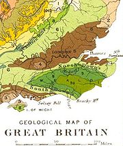
The geological map shows the High Weald in lime green (9a).
The Low Weald, the periphery of the Weald, is shown as darker green on the map (9), and has an entirely different character. It is in effect the eroded outer edges of the High Weald, revealing a mixture of sandstone outcrops within the underlying clay. As a result, the landscape is of wide and low-lying clay vales with small woodlands (“shaws”
Shaw (woodland)
A shaw is a strip of woodland usually between 5 and 15 metres wide.Shaws commonly form boundaries between fields or line a road. They are usually composed of natural woodland and often have diverse woodland ground vegetation similar to other natural woodlands in the area...
) and fields. There is a great deal of surface water: ponds and many meandering streams.
Some areas, such as the flat plain around Crawley
Crawley
Crawley is a town and local government district with Borough status in West Sussex, England. It is south of Charing Cross, north of Brighton and Hove, and northeast of the county town of Chichester, covers an area of and had a population of 99,744 at the time of the 2001 Census.The area has...
, have been utilised for urban use: here are Gatwick Airport
London Gatwick Airport
Gatwick Airport is located 3.1 miles north of the centre of Crawley, West Sussex, and south of Central London. Previously known as London Gatwick,In 2010, the name changed from London Gatwick Airport to Gatwick Airport...
and its related developments and the Horley
Horley
Horley is a town in Surrey, England, situated south of the twin towns of Reigate and Redhill, and north of Gatwick Airport and Crawley.With fast links by train to London from Horley railway station, it has grown popular with commuters in recent years...
-Crawley commuter settlements. Otherwise the Low Weald retains its historic settlement pattern, where the villages and small towns occupy harder outcrops of rocks. There are no large towns on the Low Weald, although Ashford
Ashford, Kent
Ashford is a town in the borough of Ashford in Kent, England. In 2005 it was voted the fourth best place to live in the United Kingdom. It lies on the Great Stour river, the M20 motorway, and the South Eastern Main Line and High Speed 1 railways. Its agricultural market is one of the most...
and Reigate
Reigate
Reigate is a historic market town in Surrey, England, at the foot of the North Downs, and in the London commuter belt. It is one of the main constituents of the Borough of Reigate and Banstead...
lie immediately on the northern edge. Settlements tend to be small and linear, because of its original wooded nature and heavy clay soils.
The Weald is drained by many streams radiating from it, the majority being tributaries of the surrounding major rivers: particularly of the Mole
River Mole, Surrey
The River Mole is a tributary of the River Thames in southern England. It rises in West Sussex near Gatwick Airport and flows north west through Surrey for to the Thames near Hampton Court Palace. The river gives its name to the Surrey district of Mole Valley...
, Medway
River Medway
The River Medway, which is almost entirely in Kent, England, flows for from just inside the West Sussex border to the point where it enters the Thames Estuary....
, Stour
River Stour, Kent
The River Stour is the river in Kent, England that flows into the English Channel at Pegwell Bay. Above Plucks Gutter, where the Little Stour joins it, the river is normally known as the Great Stour. The upper section of the river, above its confluence with the East Stour at Ashford is sometimes...
, Rother
River Rother (Eastern)
The River Rother , at 35 miles , is a river flowing through both East Sussex and Kent, England. Its source is near Rotherfield , and its mouth is on Rye Bay, part of the English Channel....
, Cuckmere
River Cuckmere
The River Cuckmere rises near Heathfield in East Sussex, England on the southern slopes of the Weald. The name of the river probably comes from an Old English word meaning fast-flowing, since it descends over 100 m in its initial four miles...
, Ouse
River Ouse, Sussex
The River Ouse is a river in the counties of West and East Sussex in England.-Course:The river rises near Lower Beeding and runs eastwards into East Sussex, meandering narrowly and turning slowly southward...
, Adur
River Adur
The Adur is a river in Sussex, England; it gives its name to the Adur district of West Sussex. The river was formerly navigable for large vessels up as far as Steyning, where there was a large port, but over time the river valley became silted up and the port moved down to the deeper waters nearer...
and Arun
River Arun
The Arun is a river in the English county of West Sussex. Its source is a series of small streams in the St Leonard's Forest area, to the east of Horsham...
. Many of those streams provided power to watermill
Watermill
A watermill is a structure that uses a water wheel or turbine to drive a mechanical process such as flour, lumber or textile production, or metal shaping .- History :...
s, blast furnaces and hammers which once operated the iron industry and cloth mills.
Communications
The M25M25 motorway
The M25 motorway, or London Orbital, is a orbital motorway that almost encircles Greater London, England, in the United Kingdom. The motorway was first mooted early in the 20th century. A few sections, based on the now abandoned London Ringways plan, were constructed in the early 1970s and it ...
, M26
M26 motorway
The M26 is a motorway in Kent, England. It provides a short link between the M25/A21 at Sevenoaks and the M20 near Wrotham.-Route:The motorway starts at junction 3 of the M20 and heads west, encountering almost immediately the single junction along its length where it has an interchange with the A20...
and M20 motorway
M20 motorway
The M20 is a motorway in Kent, England. It runs from the M25 motorway to Folkestone, providing a link to the Channel Tunnel and the ports at Dover. It is long...
s all use the Vale of Holmesdale
Vale of Holmesdale
The Vale of Holmesdale is a comparatively narrow valley lying at the foot of the North Downs in Surrey and Kent, England. Its composition is mainly Gault Clay, although the Lower Chalk area at the foot of the Downs is included in the area. The River Medway, for part of its length, flows along the...
to the north, and therefore run along or near the northern edge of the Weald. The M23
M23 motorway
The M23 motorway is a motorway in England. The motorway runs from south of Hooley in Surrey, where it splits from the A23, to Pease Pottage, south of Crawley in West Sussex where it rejoins the A23. The northern end of the motorway starts at junction 7 on what is effectively a spur north from...
/A23 road
A23 road
The A23 road is a major road in the United Kingdom between London and Brighton, East Sussex. It became an arterial route following the construction of Westminster Bridge in 1750 and the consequent improvement of roads leading to the bridge south of the river by the Turnpike Trusts...
to Brighton
Brighton
Brighton is the major part of the city of Brighton and Hove in East Sussex, England on the south coast of Great Britain...
, uses the western, narrower, part of the Weald where there are stream headwaters, crossing it from north to south. Other roads take similar routes, although they often have long hills and many bends: the A21 to Hastings is still beset with traffic delays, despite having had some new sections.
Five railways once crossed the Weald; building them provided the engineers with difficulties in crossing the terrain, with the hard sandstone adding to their problems. The Brighton Main Line
Brighton Main Line
The Brighton Main Line is a British railway line from London Victoria and London Bridge to Brighton. It is about 50 miles long, and is electrified throughout. Trains are operated by Southern, First Capital Connect, and Gatwick Express, now part of Southern.-Original proposals:There were no fewer...
followed the same route as its road predecessors: although it necessitated the long tunnel near Balcombe
Balcombe tunnel
Balcombe tunnel is a railway tunnel on the Brighton Main Line through the Sussex Weald between Three Bridges and Balcombe. It is 1141 yards long.-History:The tunnel was constructed by the London and Brighton Railway during 1840-41...
and the Ouse Valley Viaduct
Ouse Valley Viaduct
Built in 1841, the Ouse Valley Viaduct over the River Ouse on the London-Brighton Railway Line north of Haywards Heath and south of Balcombe is long.-Description:...
. Tributaries of the River Ouse provided some assistance in the building of now-closed East Grinstead
East Grinstead
East Grinstead is a town and civil parish in the northeastern corner of Mid Sussex, West Sussex in England near the East Sussex, Surrey, and Kent borders. It lies south of London, north northeast of Brighton, and east northeast of the county town of Chichester...
-Lewes
Lewes
Lewes is the county town of East Sussex, England and historically of all of Sussex. It is a civil parish and is the centre of the Lewes local government district. The settlement has a history as a bridging point and as a market town, and today as a communications hub and tourist-oriented town...
and the Uckfield
Uckfield
-Development:The local Tesco has proposed the redevelopment of the central town area as has the town council. The Hub has recently been completed, having been acquired for an unknown figure, presumed to be about half a million pounds...
-Lewes lines. The principal main-line railway
Hastings Line
The Hastings Line is a railway line in Kent and East Sussex linking Hastings with the main town of Tunbridge Wells, and from there into London via Sevenoaks.-Openings:The line was opened by the South Eastern Railway in main three stages: – :...
to Hastings had to negotiate difficult terrain when it was first built, necessitating many sharp curves and tunnels; and similar problems had to be faced with the Ashford-Hastings line.
The Weald is especially popular with ramblers, cyclists and other recreational users; and several Long distance footpaths cross it.
Farming
Neither the thin infertile sands of the High Weald or the wet sticky clays of the Low Weald are suited to intensive arable farming and the topographyTopography
Topography is the study of Earth's surface shape and features or those ofplanets, moons, and asteroids...
of the area often increases the difficulties. There are limited areas of fertile greensand which can be used for intensive vegetable growing, as in the valley of the Western Rother
River Rother (Western)
The River Rother is a river which flows for thirty miles from Empshott in Hampshire to Stopham in West Sussex, where it joins the River Arun. It should not be confused with the River Rother, in East Sussex....
. Historically the area of cereals grown has varied greatly with changes in prices, increasing during the Napoleonic Wars
Napoleonic Wars
The Napoleonic Wars were a series of wars declared against Napoleon's French Empire by opposing coalitions that ran from 1803 to 1815. As a continuation of the wars sparked by the French Revolution of 1789, they revolutionised European armies and played out on an unprecedented scale, mainly due to...
and during and since World War II
World War II
World War II, or the Second World War , was a global conflict lasting from 1939 to 1945, involving most of the world's nations—including all of the great powers—eventually forming two opposing military alliances: the Allies and the Axis...
. The Weald has its own breed of cattle, called the Sussex
Sussex cattle
Sussex cattle are a red breed of beef cattle from the Weald of Sussex, Surrey and Kent in south eastern England. Descended from the draught oxen long used on the Weald they were selectively bred from the late 18th century to form a modern beef breed which is now used in many countries around the...
although it has been as numerous in Kent and parts of Surrey. Bred from the strong hardy oxen, which continued to be used to plough the clay soils of the Low Weald longer than in most places, these red beef cattle were highly praised by Arthur Young in his book "Agriculture of Sussex" when visiting Sussex in the 1790s. William Cobbett
William Cobbett
William Cobbett was an English pamphleteer, farmer and journalist, who was born in Farnham, Surrey. He believed that reforming Parliament and abolishing the rotten boroughs would help to end the poverty of farm labourers, and he attacked the borough-mongers, sinecurists and "tax-eaters" relentlessly...
commented on finding some of the finest cattle on some of the region's poorest subsistence farms on the High Weald. Pigs, which were kept by most households in the past, were able to be fattened in autumn on acorns in the extensive oak woods.
Wildlife
The Weald has largely maintained its wooded character, with woodland still covering 23% of the overall area (one of the highest levels in England) and the proportion is considerably higher in some central parts. The sandstones of the Wealden rocks are usually acidic, often leading to the development of acidic habitats such as heathland, the largest remaining areas of which are in Ashdown Forest and near ThursleyThursley
Thursley is a small village in Surrey. It lies just west of the A3 running between Milford and Hindhead. Neighbouring villages include Rushmoor, Bowlhead Green and Brook. Thursley is in south-west Surrey, in south-east England...
.
Although common in France
France
The French Republic , The French Republic , The French Republic , (commonly known as France , is a unitary semi-presidential republic in Western Europe with several overseas territories and islands located on other continents and in the Indian, Pacific, and Atlantic oceans. Metropolitan France...
, the wild boar
Boar
Wild boar, also wild pig, is a species of the pig genus Sus, part of the biological family Suidae. The species includes many subspecies. It is the wild ancestor of the domestic pig, an animal with which it freely hybridises...
became extinct in Great Britain
Great Britain
Great Britain or Britain is an island situated to the northwest of Continental Europe. It is the ninth largest island in the world, and the largest European island, as well as the largest of the British Isles...
and Ireland
Ireland
Ireland is an island to the northwest of continental Europe. It is the third-largest island in Europe and the twentieth-largest island on Earth...
by the 17th century, but wild breeding populations have recently returned in the Weald, following escapes from boar farms.
Culture
The Weald has been associated with many writers, particularly in the 19th and early 20th centuries. Notable examples include John EvelynJohn Evelyn
John Evelyn was an English writer, gardener and diarist.Evelyn's diaries or Memoirs are largely contemporaneous with those of the other noted diarist of the time, Samuel Pepys, and cast considerable light on the art, culture and politics of the time John Evelyn (31 October 1620 – 27 February...
(1620–1706), Vita Sackville-West
Vita Sackville-West
The Hon Victoria Mary Sackville-West, Lady Nicolson, CH , best known as Vita Sackville-West, was an English author, poet and gardener. She won the Hawthornden Prize in 1927 and 1933...
(1892–1962), and Rudyard Kipling
Rudyard Kipling
Joseph Rudyard Kipling was an English poet, short-story writer, and novelist chiefly remembered for his celebration of British imperialism, tales and poems of British soldiers in India, and his tales for children. Kipling received the 1907 Nobel Prize for Literature...
(1864–1936). The setting for A.A. Milne's Winnie-the-Pooh
Winnie-the-Pooh
Winnie-the-Pooh, also called Pooh Bear, is a fictional anthropomorphic bear created by A. A. Milne. The first collection of stories about the character was the book Winnie-the-Pooh , and this was followed by The House at Pooh Corner...
stories was inspired by Ashdown Forest, near Milne's country home at Hartfield
Hartfield
Hartfield is a civil parish in East Sussex, England. Settlements within the parish include the village of Hartfield, Colemans Hatch, Hammerwood and Holtye, all lying on the northern edge of Ashdown Forest.-Geography:...
. In 2010, a documentary entitled "A Journey Through the Weald of Kent" was produced by Buff Films, JR Films and Cranbrook school to document the Weald's place in modern England.
Sport
The game of cricketCricket
Cricket is a bat-and-ball game played between two teams of 11 players on an oval-shaped field, at the centre of which is a rectangular 22-yard long pitch. One team bats, trying to score as many runs as possible while the other team bowls and fields, trying to dismiss the batsmen and thus limit the...
may have originated prior to the 13th century in the Weald (see History of English cricket to 1696). The related game Stoolball
Stoolball
Stoolball is a sport that dates back to at least the 15th century, originating in Sussex, southern England. It may be an ancestor of cricket , baseball, and rounders...
is still popular in the Weald, mostly played by ladies teams.
Other English Wealds and Wolds
Several other areas in southern England have the name "Weald", but are outside "the" Weald as described above. These include North Weald in Essex, and Harrow WealdHarrow Weald
Harrow Weald is an area in north-west London, England. It includes a suburban development and forms part of the London Borough of Harrow.-Locale, geography and history:...
in north-west London
London
London is the capital city of :England and the :United Kingdom, the largest metropolitan area in the United Kingdom, and the largest urban zone in the European Union by most measures. Located on the River Thames, London has been a major settlement for two millennia, its history going back to its...
.
"Wold" is used as the name for various open rolling upland areas in the North of England, including the Yorkshire Wolds
Yorkshire Wolds
The Yorkshire Wolds are low hills in the counties of East Riding of Yorkshire and North Yorkshire in northeastern England. The name also applies to the district in which the hills lie....
and the Lincolnshire Wolds
Lincolnshire Wolds
The Lincolnshire Wolds is a range of hills in the county of Lincolnshire, England. It is a designated Area of Outstanding Natural Beauty , and the highest area of land in eastern England between Yorkshire and Kent...
, although these by contrast are chalk uplands.
The Cotswolds are a major geographical feature of Central England, forming a southwest to northeast line across the country.