

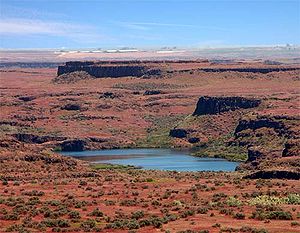
Channeled scablands
Encyclopedia
Erosion
Erosion is when materials are removed from the surface and changed into something else. It only works by hydraulic actions and transport of solids in the natural environment, and leads to the deposition of these materials elsewhere...
feature in the U.S. state
U.S. state
A U.S. state is any one of the 50 federated states of the United States of America that share sovereignty with the federal government. Because of this shared sovereignty, an American is a citizen both of the federal entity and of his or her state of domicile. Four states use the official title of...
of Washington. They were created by the cataclysm
Cataclysm
The term cataclysm The term cataclysm The term cataclysm (from the Greek kataklysmos, to 'wash down' (kluzein "wash" + kata "down") may refer to:*Deluge (mythology)*a hypothetical Doomsday event*any catastrophic geological phenomenon**volcanic eruption**earthquake...
ic Missoula Floods
Missoula Floods
The Missoula Floods refer to the cataclysmic floods that swept periodically across eastern Washington and down the Columbia River Gorge at the end of the last ice age. The glacial flood events have been researched since the 1920s...
that swept periodically across eastern Washington and down the Columbia River Plateau
Columbia River Plateau
The Columbia Plateau is a geologic and geographic region that lies across parts of the U.S. states of Washington, Oregon, and Idaho. It is a wide flood basalt plateau between the Cascade Range and the Rocky Mountains, cut through by the Columbia River...
during the Pleistocene
Pleistocene
The Pleistocene is the epoch from 2,588,000 to 11,700 years BP that spans the world's recent period of repeated glaciations. The name pleistocene is derived from the Greek and ....
epoch
Epoch (geology)
An epoch is a subdivision of the geologic timescale based on rock layering. In order, the higher subdivisions are periods, eras and eons. We are currently living in the Holocene epoch...
. Geologist
Geologist
A geologist is a scientist who studies the solid and liquid matter that constitutes the Earth as well as the processes and history that has shaped it. Geologists usually engage in studying geology. Geologists, studying more of an applied science than a theoretical one, must approach Geology using...
J Harlen Bretz
J Harlen Bretz
J Harlen Bretz was an American geologist, best known for his research that led to the acceptance of the Missoula Floods, and also for his work on caves. He was born to Oliver Joseph Bretz and Rhoda Maria Howlett, farmers in Saranac, Michigan, as the oldest of five children...
coined the term in a series of papers in the 1920s. Debate over the origin of the Scablands raged for four decades and is one of the great debates in the history of earth science
Earth science
Earth science is an all-embracing term for the sciences related to the planet Earth. It is arguably a special case in planetary science, the Earth being the only known life-bearing planet. There are both reductionist and holistic approaches to Earth sciences...
. The Scablands are also important to planetary scientists as perhaps the best terrestrial analog for the Martian outflow channels
Outflow channels
Outflow channels is the term used to describe extremely long, wide swathes of scoured ground on Mars, commonly containing the streamlined remnants of pre-existing topography and other linear erosive features indicating sculpting by fluids moving downslope...
.
Geology
River valleyRiver Valley
River Valley is the name of an urban planning area within the Central Area, Singapore's central business district.The River Valley Planning Area is defined by the region bounded by Orchard Boulevard, Devonshire Road and Eber Road to the north, Oxley Rise and Mohamed Sultan Road to the east, Martin...
s formed by erosion normally have a 'V' cross section
Cross section (geometry)
In geometry, a cross-section is the intersection of a figure in 2-dimensional space with a line, or of a body in 3-dimensional space with a plane, etc...
, and glacier
Glacier
A glacier is a large persistent body of ice that forms where the accumulation of snow exceeds its ablation over many years, often centuries. At least 0.1 km² in area and 50 m thick, but often much larger, a glacier slowly deforms and flows due to stresses induced by its weight...
s leave a 'U' cross section. The Channeled Scablands have a rectangular cross section and are spread over immense areas of eastern Washington
Eastern Washington
Eastern Washington is the portion of the U.S. state of Washington east of the Cascade Range. The region contains the city of Spokane , the Tri-Cities, the Columbia River and the Grand Coulee Dam, the Hanford Nuclear Reservation and the fertile farmlands of the Yakima Valley and the...
. They exhibit a unique drainage
Drainage
Drainage is the natural or artificial removal of surface and sub-surface water from an area. Many agricultural soils need drainage to improve production or to manage water supplies.-Early history:...
pattern that appears to have an entrance in the northeast and an exit in the southwest. The eroded channels also show an anastomosing, or braided, appearance. There are also immense pothole
Pothole
A pothole is a type of disruption in the surface of a roadway where a portion of the road material has broken away, leaving a hole.- Formation :...
s and ripple marks, much larger than those found on ordinary rivers. When first studied, no known theories could explain the origin of these features.
Bretz conducted research and published many papers during the 1920s describing the Channeled Scablands. His theories of how they were formed required short but immense water flows (500 cubic miles of water), for which Bretz had no explanation (the source of the water was never the focus of his research). Bretz's theories met with vehement opposition from geologists of the day, who tried to explain the features with uniformitarian
Uniformitarianism (science)
In the philosophy of naturalism, the uniformitarianism assumption is that the same natural laws and processes that operate in the universe now, have always operated in the universe in the past and apply everywhere in the universe. It has included the gradualistic concept that "the present is the...
theories.
J.T. Pardee
Joseph Pardee
Joseph T. Pardee was a U.S. geologist who worked for the U.S. Geological Survey, and contributed to the understanding of the origin of the Channeled scablands. He discovered the trail of evidence left by Glacial Lake Missoula, a lake created by an ice dam 23 miles wide and half a mile high during...
first suggested in 1925 to Bretz that the draining of a glacial lake
Proglacial lake
In geology, a proglacial lake is a lake formed either by the damming action of a moraine or ice dam during the retreat of a melting glacier, or by meltwater trapped against an ice sheet due to isostatic depression of the crust around the ice...
could account for flows of the magnitude needed. Pardee continued his research over the next 30 years, collecting and analyzing evidence that eventually identified Lake Missoula
Glacial Lake Missoula
Glacial Lake Missoula was a prehistoric proglacial lake in western Montana that existed periodically at the end of the last ice age between 15,000 and 13,000 years ago...
as the source of the Spokane Floods
Missoula Floods
The Missoula Floods refer to the cataclysmic floods that swept periodically across eastern Washington and down the Columbia River Gorge at the end of the last ice age. The glacial flood events have been researched since the 1920s...
and creator of the Channeled Scablands.
Research on open channel hydraulics in the 1970s put Bretz's theories on solid scientific ground.
Pardee's and Bretz's theories were accepted only after decades of painstaking work and fierce scientific debate. In 1979 Bretz received the highest medal of the Geological Society of America
Geological Society of America
The Geological Society of America is a nonprofit organization dedicated to the advancement of the geosciences. The society was founded in New York in 1888 by Alexander Winchell, John J. Stevenson, Charles H. Hitchcock, John R. Proctor and Edward Orton and has been headquartered at 3300 Penrose...
, the Penrose Medal
Penrose Medal
The Penrose Medal was created in 1927 by R.A.F. Penrose, Jr. as the top prize awarded by the Geological Society of America to those who advance the study of geoscience.-Award winners:* 2011 Paul F. Hoffman* 2010 Eric J. Essene* 2009 B. Clark Burchfiel...
, to recognize that he had developed one of the great ideas in the earth sciences.
See also
- CouleeCouleeCoulee is applied rather loosely to different landforms, all of which refer to a kind of valley or drainage zone.The word coulee comes from the Canadian French coulée, from French word couler meaning "to flow"....
- Glacial lake outburst floodGlacial lake outburst floodA glacial lake outburst flood is a type of outburst flood that occurs when the dam containing a glacial lake fails. The dam can consist of glacier ice or a terminal moraine...
- Drumheller Channels National Natural LandmarkDrumheller Channels National Natural LandmarkDrumheller Channels National Natural Landmark showcases the Drumheller Channels, which are the most significant example in the Columbia Plateau of basalt butte-and-basin channeled scablands...
- Dry FallsDry FallsDry Falls is a 3.5 mile long scalloped precipice in central Washington, on the opposite side of the Upper Grand Coulee from the Columbia River, and at the head of the Lower Grand Coulee. Ten times the size of Niagara, Dry Falls is thought to be the greatest known waterfall that ever existed...
- Giant current ripplesGiant current ripplesGiant current ripples are active channel topographic forms up to 20 m high, which develop within near-talweg areas of the main outflow valleys crated by glacial lake outburst floods...
- DiluviumDiluviumDiluvium is a term in geology for superficial deposits formed by flood-like operations of water, and so contrasted with alluvium or alluvial deposits formed by slow and steady aqueous agencies...
- Outflow channelsOutflow channelsOutflow channels is the term used to describe extremely long, wide swathes of scoured ground on Mars, commonly containing the streamlined remnants of pre-existing topography and other linear erosive features indicating sculpting by fluids moving downslope...
- Altai floodAltai floodThe Altai flood refers to the cataclysmic flood that swept along the Katun River in the Republic of Altai at the end of the last ice age. These glacial lake outburst floods were the result of periodic sudden ruptures of ice dams like those triggering the Missoula flood.-Background:Large glacial...
External links
- United States Geological Survey The Channeled Scablands of Eastern Washington
- Steven Dutch, University of Wisconsin - Green Bay, Channeled Scablands: Overview
- Historical Discussion
- 3D relief map (left eye-red lens, right eye-blue lens)
- PBSPublic Broadcasting ServiceThe Public Broadcasting Service is an American non-profit public broadcasting television network with 354 member TV stations in the United States which hold collective ownership. Its headquarters is in Arlington, Virginia....
's NOVANOVA (TV series)Nova is a popular science television series from the U.S. produced by WGBH Boston. It can be seen on the Public Broadcasting Service in the United States, and in more than 100 other countries...
: Mystery of the Megaflood - Scablands in Google Maps
- Online book from the National Park ServiceNational Park ServiceThe National Park Service is the U.S. federal agency that manages all national parks, many national monuments, and other conservation and historical properties with various title designations...
about the geologic origins of the scablands. - Sun Lakes-Dry Falls State Park in the Channeled Scablands
- Columbia Plateau Trail StatePark in the Channeled Scablands
- The Seattle Times' Pacific NW magazine - "Trailing an Apocalypse" - 30-Sep-2007
- The channeled scabland: a guide to the geomorphology of the Columbia Basin, Washington : prepared for the Comparative Planetary Geology Field Conference held in the Columbia Basin, June 5-8, 1978 / sponsored by Planetary Geology Program, Office of Space Science, National Aeronautics and Space Administration ; edited by Victor R. Baker and Dag Nummedal.
- Keenan Lee. Altai Flood
- ru: А. Н. Рудой. 1. Study diluvium: general provisions. Общие положения учения о дилювии. 2. Scablands. Скэбленд: экзотические ландшафты.
- Rudoy A.N. Glacier-dammed lakes and geological work of glacial superfloods in the Late Pleistocene, Southern Siberia, Altai Mountains, Quaternary International, 2002, Vol. 87/1, pp. 119-140.