

Geology of Scotland
Encyclopedia
Scotland
Scotland is a country that is part of the United Kingdom. Occupying the northern third of the island of Great Britain, it shares a border with England to the south and is bounded by the North Sea to the east, the Atlantic Ocean to the north and west, and the North Channel and Irish Sea to the...
is unusually varied for a country of its size, with a large number of differing geological
Geology
Geology is the science comprising the study of solid Earth, the rocks of which it is composed, and the processes by which it evolves. Geology gives insight into the history of the Earth, as it provides the primary evidence for plate tectonics, the evolutionary history of life, and past climates...
features. There are three main geographical sub-divisions: the Highlands and Islands
Highlands and Islands
The Highlands and Islands of Scotland are broadly the Scottish Highlands plus Orkney, Shetland and the Hebrides.The Highlands and Islands are sometimes defined as the area to which the Crofters' Act of 1886 applied...
is a diverse area which lies to the north and west of the Highland Boundary Fault
Highland Boundary Fault
The Highland Boundary Fault is a geological fault that traverses Scotland from Arran and Helensburgh on the west coast to Stonehaven in the east...
; the Central Lowlands
Central Lowlands
The Central Lowlands or Midland Valley is a geologically defined area of relatively low-lying land in southern Scotland. It consists of a rift valley between the Highland Boundary Fault to the north and the Southern Uplands Fault to the south...
is a rift valley
Rift valley
A rift valley is a linear-shaped lowland between highlands or mountain ranges created by the action of a geologic rift or fault. This action is manifest as crustal extension, a spreading apart of the surface which is subsequently further deepened by the forces of erosion...
mainly comprising Paleozoic
Paleozoic
The Paleozoic era is the earliest of three geologic eras of the Phanerozoic eon, spanning from roughly...
formations; and the Southern Uplands
Southern Uplands
The Southern Uplands are the southernmost and least populous of mainland Scotland's three major geographic areas . The term is used both to describe the geographical region and to collectively denote the various ranges of hills within this region...
, which lie south of the Southern Uplands Fault
Southern Uplands Fault
The Southern Uplands Fault is a fault in Scotland that runs from Girvan to Dunbar on the East coast. It marks the southern boundary of the Scottish Midland Valley....
, are largely composed of Silurian
Silurian
The Silurian is a geologic period and system that extends from the end of the Ordovician Period, about 443.7 ± 1.5 Mya , to the beginning of the Devonian Period, about 416.0 ± 2.8 Mya . As with other geologic periods, the rock beds that define the period's start and end are well identified, but the...
deposits.
The existing bedrock includes very ancient Archean
Archean
The Archean , also spelled Archeozoic or Archæozoic) is a geologic eon before the Paleoproterozoic Era of the Proterozoic Eon, before 2.5 Ga ago. Instead of being based on stratigraphy, this date is defined chronometrically...
gneiss
Gneiss
Gneiss is a common and widely distributed type of rock formed by high-grade regional metamorphic processes from pre-existing formations that were originally either igneous or sedimentary rocks.-Etymology:...
, metamorphic
Metamorphic rock
Metamorphic rock is the transformation of an existing rock type, the protolith, in a process called metamorphism, which means "change in form". The protolith is subjected to heat and pressure causing profound physical and/or chemical change...
beds interspersed with granite
Granite
Granite is a common and widely occurring type of intrusive, felsic, igneous rock. Granite usually has a medium- to coarse-grained texture. Occasionally some individual crystals are larger than the groundmass, in which case the texture is known as porphyritic. A granitic rock with a porphyritic...
intrusions created during the Caledonian mountain building period (the Caledonian orogeny
Caledonian orogeny
The Caledonian orogeny is a mountain building era recorded in the northern parts of the British Isles, the Scandinavian Mountains, Svalbard, eastern Greenland and parts of north-central Europe. The Caledonian orogeny encompasses events that occurred from the Ordovician to Early Devonian, roughly...
), commercially important coal
Coal
Coal is a combustible black or brownish-black sedimentary rock usually occurring in rock strata in layers or veins called coal beds or coal seams. The harder forms, such as anthracite coal, can be regarded as metamorphic rock because of later exposure to elevated temperature and pressure...
, oil
Oil
An oil is any substance that is liquid at ambient temperatures and does not mix with water but may mix with other oils and organic solvents. This general definition includes vegetable oils, volatile essential oils, petrochemical oils, and synthetic oils....
and iron
Iron
Iron is a chemical element with the symbol Fe and atomic number 26. It is a metal in the first transition series. It is the most common element forming the planet Earth as a whole, forming much of Earth's outer and inner core. It is the fourth most common element in the Earth's crust...
bearing carboniferous
Carboniferous
The Carboniferous is a geologic period and system that extends from the end of the Devonian Period, about 359.2 ± 2.5 Mya , to the beginning of the Permian Period, about 299.0 ± 0.8 Mya . The name is derived from the Latin word for coal, carbo. Carboniferous means "coal-bearing"...
deposits and the remains of substantial tertiary
Tertiary
The Tertiary is a deprecated term for a geologic period 65 million to 2.6 million years ago. The Tertiary covered the time span between the superseded Secondary period and the Quaternary...
volcano
Volcano
2. Bedrock3. Conduit 4. Base5. Sill6. Dike7. Layers of ash emitted by the volcano8. Flank| 9. Layers of lava emitted by the volcano10. Throat11. Parasitic cone12. Lava flow13. Vent14. Crater15...
es. During their formation, tectonic movements created climatic conditions ranging from polar to desert to tropical and a resultant diversity of fossil
Fossil
Fossils are the preserved remains or traces of animals , plants, and other organisms from the remote past...
remains.
Scotland has also had a role to play in many significant discoveries such as plate tectonics
Plate tectonics
Plate tectonics is a scientific theory that describes the large scale motions of Earth's lithosphere...
and the development of theories about the formation of rocks
Petrology
Petrology is the branch of geology that studies rocks, and the conditions in which rocks form....
and was the home of important figures in the development of the science including James Hutton
James Hutton
James Hutton was a Scottish physician, geologist, naturalist, chemical manufacturer and experimental agriculturalist. He is considered the father of modern geology...
, (the "father of modern geology") Hugh Miller
Hugh Miller
Hugh Miller was a self-taught Scottish geologist and writer, folklorist and an evangelical Christian.- Life and work :Born in Cromarty, he was educated in a parish school where he reportedly showed a love of reading. At 17 he was apprenticed to a stonemason, and his work in quarries, together with...
and Archibald Geikie
Archibald Geikie
Sir Archibald Geikie, OM, KCB, PRS, FRSE , was a Scottish geologist and writer.-Early life:Geikie was born in Edinburgh in 1835, the eldest son of musician and music critic James Stuart Geikie...
. Various locations such as 'Hutton's Unconformity
Hutton's Unconformity
Hutton's Unconformity is any of various famous geological sites in Scotland. These are places identified by 18th-century Scottish geologist James Hutton as an unconformity, which provided evidence for his Plutonist theories of uniformitarianism and about the age of the Earth.-Theory of rock...
' at Siccar Point
Siccar Point
Siccar Point is a rocky promontory in the county of Berwickshire on the east coast of Scotland.It is famous in the history of geology for Hutton's Unconformity found in 1788, which James Hutton regarded as conclusive proof of his uniformitarian theory of geological development.-History:Siccar...
in Berwickshire and the Moine Thrust
Moine Thrust Belt
The Moine Thrust Belt is a linear geological feature in the Scottish Highlands which runs from Loch Eriboll on the north coast 190 km south-west to the Sleat peninsula on the Isle of Skye...
in the north west were also important in the development of geological science.
Overview
_named_(hr).png)
Geology
Geology is the science comprising the study of solid Earth, the rocks of which it is composed, and the processes by which it evolves. Geology gives insight into the history of the Earth, as it provides the primary evidence for plate tectonics, the evolutionary history of life, and past climates...
and geomorphological
Geomorphology
Geomorphology is the scientific study of landforms and the processes that shape them...
perspective the country has three main sub-divisions all of which were affected by Pleistocene
Pleistocene
The Pleistocene is the epoch from 2,588,000 to 11,700 years BP that spans the world's recent period of repeated glaciations. The name pleistocene is derived from the Greek and ....
glaciations.
Highlands and Islands
The Highlands and Islands lie to the north and west of the Highland Boundary FaultHighland Boundary Fault
The Highland Boundary Fault is a geological fault that traverses Scotland from Arran and Helensburgh on the west coast to Stonehaven in the east...
, which runs from Arran
Isle of Arran
Arran or the Isle of Arran is the largest island in the Firth of Clyde, Scotland, and with an area of is the seventh largest Scottish island. It is in the unitary council area of North Ayrshire and the 2001 census had a resident population of 5,058...
to Stonehaven
Stonehaven
Stonehaven is a town in Aberdeenshire, Scotland. It lies on Scotland's northeast coast and had a population of 9,577 in 2001 census.Stonehaven, county town of Kincardineshire, grew around an Iron Age fishing village, now the "Auld Toon" , and expanded inland from the seaside...
. This part of Scotland largely comprises ancient rocks, from the Cambrian
Cambrian
The Cambrian is the first geological period of the Paleozoic Era, lasting from Mya ; it is succeeded by the Ordovician. Its subdivisions, and indeed its base, are somewhat in flux. The period was established by Adam Sedgwick, who named it after Cambria, the Latin name for Wales, where Britain's...
and Precambrian
Precambrian
The Precambrian is the name which describes the large span of time in Earth's history before the current Phanerozoic Eon, and is a Supereon divided into several eons of the geologic time scale...
eras, that were uplifted to form a mountain chain during the later Caledonian orogeny
Orogeny
Orogeny refers to forces and events leading to a severe structural deformation of the Earth's crust due to the engagement of tectonic plates. Response to such engagement results in the formation of long tracts of highly deformed rock called orogens or orogenic belts...
. These foundations are interspersed with many igneous
Igneous rock
Igneous rock is one of the three main rock types, the others being sedimentary and metamorphic rock. Igneous rock is formed through the cooling and solidification of magma or lava...
intrusions of a more recent age, the remnants of which have formed mountain massifs such as the Cairngorms
Cairngorms
The Cairngorms are a mountain range in the eastern Highlands of Scotland closely associated with the mountain of the same name - Cairn Gorm.-Name:...
and Skye
Skye
Skye or the Isle of Skye is the largest and most northerly island in the Inner Hebrides of Scotland. The island's peninsulas radiate out from a mountainous centre dominated by the Cuillin hills...
Cuillins. A significant exception to the above are the fossil-bearing beds of Old Red Sandstone
Old Red Sandstone
The Old Red Sandstone is a British rock formation of considerable importance to early paleontology. For convenience the short version of the term, 'ORS' is often used in literature on the subject.-Sedimentology:...
s found principally along the Moray Firth
Moray Firth
The Moray Firth is a roughly triangular inlet of the North Sea, north and east of Inverness, which is in the Highland council area of north of Scotland...
coast and in the Orkney islands. These rocks are around 400 million years old, and were laid down in the Devonian
Devonian
The Devonian is a geologic period and system of the Paleozoic Era spanning from the end of the Silurian Period, about 416.0 ± 2.8 Mya , to the beginning of the Carboniferous Period, about 359.2 ± 2.5 Mya...
period. The Highlands
Scottish Highlands
The Highlands is an historic region of Scotland. The area is sometimes referred to as the "Scottish Highlands". It was culturally distinguishable from the Lowlands from the later Middle Ages into the modern period, when Lowland Scots replaced Scottish Gaelic throughout most of the Lowlands...
are generally mountainous and are bisected by the Great Glen Fault
Great Glen Fault
The Great Glen Fault is a long strike-slip fault that runs through its namesake the Great Glen in Scotland. However, the fault is actually much longer and over 400 million years old.-Location:...
. The highest elevations in the British Isles
British Isles
The British Isles are a group of islands off the northwest coast of continental Europe that include the islands of Great Britain and Ireland and over six thousand smaller isles. There are two sovereign states located on the islands: the United Kingdom of Great Britain and Northern Ireland and...
are found here, including Ben Nevis
Ben Nevis
Ben Nevis is the highest mountain in the British Isles. It is located at the western end of the Grampian Mountains in the Lochaber area of the Scottish Highlands, close to the town of Fort William....
, the highest peak at 1,344 metres (4,409 ft). Scotland has over 790 islands, divided into four main groups: Shetland
Shetland Islands
Shetland is a subarctic archipelago of Scotland that lies north and east of mainland Great Britain. The islands lie some to the northeast of Orkney and southeast of the Faroe Islands and form part of the division between the Atlantic Ocean to the west and the North Sea to the east. The total...
, Orkney
Orkney Islands
Orkney also known as the Orkney Islands , is an archipelago in northern Scotland, situated north of the coast of Caithness...
, and the Hebrides
Hebrides
The Hebrides comprise a widespread and diverse archipelago off the west coast of Scotland. There are two main groups: the Inner and Outer Hebrides. These islands have a long history of occupation dating back to the Mesolithic and the culture of the residents has been affected by the successive...
, further sub-divided into the Inner Hebrides
Inner Hebrides
The Inner Hebrides is an archipelago off the west coast of Scotland, to the south east of the Outer Hebrides. Together these two island chains form the Hebrides, which enjoy a mild oceanic climate. There are 36 inhabited islands and a further 43 uninhabited Inner Hebrides with an area greater than...
and Outer Hebrides
Outer Hebrides
The Outer Hebrides also known as the Western Isles and the Long Island, is an island chain off the west coast of Scotland. The islands are geographically contiguous with Comhairle nan Eilean Siar, one of the 32 unitary council areas of Scotland...
.

St Kilda, Scotland
St Kilda is an isolated archipelago west-northwest of North Uist in the North Atlantic Ocean. It contains the westernmost islands of the Outer Hebrides of Scotland. The largest island is Hirta, whose sea cliffs are the highest in the United Kingdom and three other islands , were also used for...
is composed of Tertiary
Tertiary
The Tertiary is a deprecated term for a geologic period 65 million to 2.6 million years ago. The Tertiary covered the time span between the superseded Secondary period and the Quaternary...
igneous formations of granites and gabbro
Gabbro
Gabbro refers to a large group of dark, coarse-grained, intrusive mafic igneous rocks chemically equivalent to basalt. The rocks are plutonic, formed when molten magma is trapped beneath the Earth's surface and cools into a crystalline mass....
, heavily weathered by the elements. These islands represent the remnants of a long extinct ring volcano rising from a seabed plateau approximately 40 m (130 ft) below sea level.
The geology of Shetland is complex with numerous faults and fold axes. These islands are the northern outpost of the Caledonian orogeny
Caledonian orogeny
The Caledonian orogeny is a mountain building era recorded in the northern parts of the British Isles, the Scandinavian Mountains, Svalbard, eastern Greenland and parts of north-central Europe. The Caledonian orogeny encompasses events that occurred from the Ordovician to Early Devonian, roughly...
and there are outcrops of Lewisian, Dalriadan and Moine metamorphic rocks with similar histories to their equivalents on the Scottish mainland. Similarly, there are also Old Red Sandstone
Old Red Sandstone
The Old Red Sandstone is a British rock formation of considerable importance to early paleontology. For convenience the short version of the term, 'ORS' is often used in literature on the subject.-Sedimentology:...
deposits and granite
Granite
Granite is a common and widely occurring type of intrusive, felsic, igneous rock. Granite usually has a medium- to coarse-grained texture. Occasionally some individual crystals are larger than the groundmass, in which case the texture is known as porphyritic. A granitic rock with a porphyritic...
intrusions. The most distinctive feature is the ultrabasic ophiolite
Ophiolites
An ophiolite is a section of the Earth's oceanic crust and the underlying upper mantle that has been uplifted and exposed above sea level and often emplaced onto continental crustal rocks...
peridotite
Peridotite
A peridotite is a dense, coarse-grained igneous rock, consisting mostly of the minerals olivine and pyroxene. Peridotite is ultramafic, as the rock contains less than 45% silica. It is high in magnesium, reflecting the high proportions of magnesium-rich olivine, with appreciable iron...
and gabbro
Gabbro
Gabbro refers to a large group of dark, coarse-grained, intrusive mafic igneous rocks chemically equivalent to basalt. The rocks are plutonic, formed when molten magma is trapped beneath the Earth's surface and cools into a crystalline mass....
on Unst
Unst
Unst is one of the North Isles of the Shetland Islands, Scotland. It is the northernmost of the inhabited British Isles and is the third largest island in Shetland after the Mainland and Yell. It has an area of .Unst is largely grassland, with coastal cliffs...
and Fetlar
Fetlar
Fetlar is one of the North Isles of Shetland, Scotland, with a population of 86 at the time of the 2001 census. Its main settlement is Houbie on the south coast, home to the Fetlar Interpretive Centre...
, which are remnants of the Iapetus Ocean
Iapetus Ocean
The Iapetus Ocean was an ocean that existed in the Neoproterozoic and Paleozoic eras of the geologic timescale . The Iapetus Ocean was situated in the southern hemisphere, between the paleocontinents of Laurentia, Baltica and Avalonia...
floor. Much of Shetland's economy depends on the oil-bearing sediments in the surrounding seas.
Midland Valley
Often referred to as the Central LowlandsCentral Lowlands
The Central Lowlands or Midland Valley is a geologically defined area of relatively low-lying land in southern Scotland. It consists of a rift valley between the Highland Boundary Fault to the north and the Southern Uplands Fault to the south...
, this is a rift valley
Rift valley
A rift valley is a linear-shaped lowland between highlands or mountain ranges created by the action of a geologic rift or fault. This action is manifest as crustal extension, a spreading apart of the surface which is subsequently further deepened by the forces of erosion...
mainly comprising Paleozoic
Paleozoic
The Paleozoic era is the earliest of three geologic eras of the Phanerozoic eon, spanning from roughly...
formations. Many of these sediments have economic significance for it is here that the coal and iron bearing rocks that fuelled Scotland's industrial revolution
Industrial Revolution
The Industrial Revolution was a period from the 18th to the 19th century where major changes in agriculture, manufacturing, mining, transportation, and technology had a profound effect on the social, economic and cultural conditions of the times...
are to be found. This area has also experienced intense vulcanism
Volcano
2. Bedrock3. Conduit 4. Base5. Sill6. Dike7. Layers of ash emitted by the volcano8. Flank| 9. Layers of lava emitted by the volcano10. Throat11. Parasitic cone12. Lava flow13. Vent14. Crater15...
, Arthur’s Seat
Arthur's Seat, Edinburgh
Arthur's Seat is the main peak of the group of hills which form most of Holyrood Park, described by Robert Louis Stevenson as "a hill for magnitude, a mountain in virtue of its bold design". It is situated in the centre of the city of Edinburgh, about a mile to the east of Edinburgh Castle...
in Edinburgh
Edinburgh
Edinburgh is the capital city of Scotland, the second largest city in Scotland, and the eighth most populous in the United Kingdom. The City of Edinburgh Council governs one of Scotland's 32 local government council areas. The council area includes urban Edinburgh and a rural area...
being the remnant of a once much larger volcano
Volcano
2. Bedrock3. Conduit 4. Base5. Sill6. Dike7. Layers of ash emitted by the volcano8. Flank| 9. Layers of lava emitted by the volcano10. Throat11. Parasitic cone12. Lava flow13. Vent14. Crater15...
active in the Carboniferous
Carboniferous
The Carboniferous is a geologic period and system that extends from the end of the Devonian Period, about 359.2 ± 2.5 Mya , to the beginning of the Permian Period, about 299.0 ± 0.8 Mya . The name is derived from the Latin word for coal, carbo. Carboniferous means "coal-bearing"...
period some 300 million years ago. This area is relatively low-lying, although even here hills such as the Ochils
Ochil Hills
The Ochil Hills is a range of hills in Scotland north of the Forth valley bordered by the towns of Stirling, Alloa, Kinross and Perth. The only major roads crossing the hills pass through Glen Devon/Glen Eagles and Glenfarg, the latter now largely replaced except for local traffic by the M90...
and Campsie Fells
Campsie Fells
The Campsie Fells are a range of hills in central Scotland, stretching east to west, from Denny Muir to Dumgoyne, in Stirlingshire. . The highest point in the range is Earl's Seat which is 578 m high...
are rarely far from view.
Southern Uplands
Southern Uplands
The Southern Uplands are the southernmost and least populous of mainland Scotland's three major geographic areas . The term is used both to describe the geographical region and to collectively denote the various ranges of hills within this region...
are a range of hills almost 200 km (124.3 mi) long, interspersed with broad valleys. They lie south of a second fault line running from Ballantrae
Ballantrae
Ballantrae is a community in Carrick, South Ayrshire, Scotland. The name probably comes from the Scottish Gaelic Baile na Tràgha, meaning the "town by the beach"....
towards Dunbar
Dunbar
Dunbar is a town in East Lothian on the southeast coast of Scotland, approximately 28 miles east of Edinburgh and 28 miles from the English Border at Berwick-upon-Tweed....
. The geological foundations largely comprise Silurian
Silurian
The Silurian is a geologic period and system that extends from the end of the Ordovician Period, about 443.7 ± 1.5 Mya , to the beginning of the Devonian Period, about 416.0 ± 2.8 Mya . As with other geologic periods, the rock beds that define the period's start and end are well identified, but the...
deposits laid down some 4-500 million years ago.
Post-glacial events
The whole of Scotland was covered by ice sheets during the PleistocenePleistocene
The Pleistocene is the epoch from 2,588,000 to 11,700 years BP that spans the world's recent period of repeated glaciations. The name pleistocene is derived from the Greek and ....
ice ages and the landscape is much affected by glaciation, and to a lesser extent by subsequent sea level changes. In the post-glacial epoch, circa 6100 BC, Scotland and the Faeroe Islands experienced a tsunami
Tsunami
A tsunami is a series of water waves caused by the displacement of a large volume of a body of water, typically an ocean or a large lake...
up to 20 metres high caused by the Storegga Slide
Storegga Slide
The three Storegga Slides are considered to be amongst the largest known landslides. They occurred under water, at the edge of Norway's continental shelf , in the Norwegian Sea, 100 km north-west of the Møre coast, causing a very large tsunami in the North Atlantic Ocean...
s, an immense underwater landslip off the coast of Norway. Earth tremors are infrequent and usually slight. The Great Glen is the most seismically active area of Britain, but the last event of any size was in 1901.
Archean and Proterozoic eons
The oldest rocks of Scotland are the Lewisian gneissesLewisian complex
The Lewisian complex or Lewisian Gneiss is a suite of Precambrian metamorphic rocks that outcrop in the northwestern part of Scotland, forming part of the Hebridean Terrane. These rocks are of Archaean and Paleoproterozoic age, ranging from 3.0–1.7 Ga. They form the basement on which the...
, which were formed in the Precambrian
Precambrian
The Precambrian is the name which describes the large span of time in Earth's history before the current Phanerozoic Eon, and is a Supereon divided into several eons of the geologic time scale...
period, up to 3,000 Ma (million years ago). They are the oldest in Europe and amongst the oldest rocks in the world. They form the basement to the west of the Moine Thrust
Moine Thrust Belt
The Moine Thrust Belt is a linear geological feature in the Scottish Highlands which runs from Loch Eriboll on the north coast 190 km south-west to the Sleat peninsula on the Isle of Skye...
on the mainland, in the Outer Hebrides
Outer Hebrides
The Outer Hebrides also known as the Western Isles and the Long Island, is an island chain off the west coast of Scotland. The islands are geographically contiguous with Comhairle nan Eilean Siar, one of the 32 unitary council areas of Scotland...
and on the islands of Coll
Coll
Coll is a small island, west of Mull in the Inner Hebrides of Scotland. Coll is known for its sandy beaches, which rise to form large sand dunes, for its corncrakes, and for Breachacha Castle.-Geography and geology:...
and Tiree
Tiree
-History:Tiree is known for the 1st century BC Dùn Mòr broch, for the prehistoric carved Ringing Stone and for the birds of the Ceann a' Mhara headland....
. These rocks are largely igneous in origin, mixed with metamorphosed marble
Marble
Marble is a metamorphic rock composed of recrystallized carbonate minerals, most commonly calcite or dolomite.Geologists use the term "marble" to refer to metamorphosed limestone; however stonemasons use the term more broadly to encompass unmetamorphosed limestone.Marble is commonly used for...
, quartzite
Quartzite
Quartzite is a hard metamorphic rock which was originally sandstone. Sandstone is converted into quartzite through heating and pressure usually related to tectonic compression within orogenic belts. Pure quartzite is usually white to gray, though quartzites often occur in various shades of pink...
and mica schist and intruded by later basaltic dykes and granite magma. One of these intrusions forms the summit plateau of the mountain Roineabhal
Roineabhal
Roineabhal is a hill on the Isle of Harris, in the Western Isles of Scotland. The granite on the summit plateau of the mountain is anorthosite, and is similar in composition to rocks found in the mountains of the Moon....
in Harris. The granite here is anorthosite
Anorthosite
Anorthosite is a phaneritic, intrusive igneous rock characterized by a predominance of plagioclase feldspar , and a minimal mafic component...
, and is similar in composition to rocks found in the mountains of the Moon
Moon
The Moon is Earth's only known natural satellite,There are a number of near-Earth asteroids including 3753 Cruithne that are co-orbital with Earth: their orbits bring them close to Earth for periods of time but then alter in the long term . These are quasi-satellites and not true moons. For more...
.

Limestone
Limestone is a sedimentary rock composed largely of the minerals calcite and aragonite, which are different crystal forms of calcium carbonate . Many limestones are composed from skeletal fragments of marine organisms such as coral or foraminifera....
s muds and lava
Lava
Lava refers both to molten rock expelled by a volcano during an eruption and the resulting rock after solidification and cooling. This molten rock is formed in the interior of some planets, including Earth, and some of their satellites. When first erupted from a volcanic vent, lava is a liquid at...
s were deposited in what is now the Highlands of Scotland
Scottish Highlands
The Highlands is an historic region of Scotland. The area is sometimes referred to as the "Scottish Highlands". It was culturally distinguishable from the Lowlands from the later Middle Ages into the modern period, when Lowland Scots replaced Scottish Gaelic throughout most of the Lowlands...
.
Cambrian period
Further sedimentary deposits were formed through the CambrianCambrian
The Cambrian is the first geological period of the Paleozoic Era, lasting from Mya ; it is succeeded by the Ordovician. Its subdivisions, and indeed its base, are somewhat in flux. The period was established by Adam Sedgwick, who named it after Cambria, the Latin name for Wales, where Britain's...
period, (542–488 Ma) some of which, along with the earlier Precambrian sediments, metamorphosed
Metamorphic rock
Metamorphic rock is the transformation of an existing rock type, the protolith, in a process called metamorphism, which means "change in form". The protolith is subjected to heat and pressure causing profound physical and/or chemical change...
into the Dalradian
Dalradian
Dalradian in geology describes a series of metamorphic rocks, typically developed in the high ground which lies southeast of the Great Glen of Scotland...
series. This is composed of a wide variety of materials, including mica schist, biotite
Biotite
Biotite is a common phyllosilicate mineral within the mica group, with the approximate chemical formula . More generally, it refers to the dark mica series, primarily a solid-solution series between the iron-endmember annite, and the magnesium-endmember phlogopite; more aluminous endmembers...
gneiss schist, schistose grit, greywacke
Greywacke
Greywacke or Graywacke is a variety of sandstone generally characterized by its hardness, dark color, and poorly sorted angular grains of quartz, feldspar, and small rock fragments or lithic fragments set in a compact, clay-fine matrix. It is a texturally immature sedimentary rock generally found...
and quartzite
Quartzite
Quartzite is a hard metamorphic rock which was originally sandstone. Sandstone is converted into quartzite through heating and pressure usually related to tectonic compression within orogenic belts. Pure quartzite is usually white to gray, though quartzites often occur in various shades of pink...
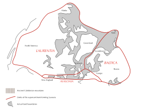
. The area that would become Scotland was at this time close to the south pole and part of Laurentia
Laurentia
Laurentia is a large area of continental craton, which forms the ancient geological core of the North American continent...
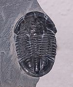
. Fossils from the north-west Highlands indicate the presence of trilobite
Trilobite
Trilobites are a well-known fossil group of extinct marine arthropods that form the class Trilobita. The first appearance of trilobites in the fossil record defines the base of the Atdabanian stage of the Early Cambrian period , and they flourished throughout the lower Paleozoic era before...
s and other primitive forms of life.
Ordovician period
The proto-Scotland landmass moved northwards and from 460–430 Ma sandstoneSandstone
Sandstone is a sedimentary rock composed mainly of sand-sized minerals or rock grains.Most sandstone is composed of quartz and/or feldspar because these are the most common minerals in the Earth's crust. Like sand, sandstone may be any colour, but the most common colours are tan, brown, yellow,...
, mudstone
Mudstone
Mudstone is a fine grained sedimentary rock whose original constituents were clays or muds. Grain size is up to 0.0625 mm with individual grains too small to be distinguished without a microscope. With increased pressure over time the platey clay minerals may become aligned, with the...
and limestone
Limestone
Limestone is a sedimentary rock composed largely of the minerals calcite and aragonite, which are different crystal forms of calcium carbonate . Many limestones are composed from skeletal fragments of marine organisms such as coral or foraminifera....
was deposited in the area that is now the Midland Valley
Central Lowlands
The Central Lowlands or Midland Valley is a geologically defined area of relatively low-lying land in southern Scotland. It consists of a rift valley between the Highland Boundary Fault to the north and the Southern Uplands Fault to the south...
. This occurred in shallow tropical seas at the margins of the Iapetus Ocean
Iapetus Ocean
The Iapetus Ocean was an ocean that existed in the Neoproterozoic and Paleozoic eras of the geologic timescale . The Iapetus Ocean was situated in the southern hemisphere, between the paleocontinents of Laurentia, Baltica and Avalonia...
. The Ballantrae Complex near Girvan
Girvan
Girvan is a burgh in Carrick, South Ayrshire, Scotland, with a population of about 8000 people. Originally a fishing port, it is now also a seaside resort with beaches and cliffs. Girvan dates back to 1668 when is became a municipal burgh incorporated by by charter...
was formed from this ocean floor and is similar in composition to rocks found at The Lizard
The Lizard
The Lizard is a peninsula in south Cornwall, England, United Kingdom. The most southerly point of the British mainland is near Lizard Point at ....
in Cornwall
Cornwall
Cornwall is a unitary authority and ceremonial county of England, within the United Kingdom. It is bordered to the north and west by the Celtic Sea, to the south by the English Channel, and to the east by the county of Devon, over the River Tamar. Cornwall has a population of , and covers an area of...
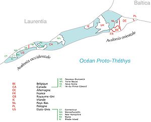
. Nonetheless, northern and southern Britain were far apart at the beginning of this period, although the gap began to close as the continent of Avalonia
Avalonia
Avalonia was a microcontinent in the Paleozoic era. Crustal fragments of this former microcontinent underlie south-west Great Britain, and the eastern coast of North America. It is the source of many of the older rocks of Western Europe, Atlantic Canada, and parts of the coastal United States...
broke away from Gondwana
Gondwana
In paleogeography, Gondwana , originally Gondwanaland, was the southernmost of two supercontinents that later became parts of the Pangaea supercontinent. It existed from approximately 510 to 180 million years ago . Gondwana is believed to have sutured between ca. 570 and 510 Mya,...
, collided with Baltica
Baltica
Baltica is a name applied by geologists to a late-Proterozoic, early-Palaeozoic continent that now includes the East European craton of northwestern Eurasia. Baltica was created as an entity not earlier than 1.8 billion years ago. Before this time, the three segments/continents that now comprise...
and drifted towards Laurentia. The Caledonian orogeny
Caledonian orogeny
The Caledonian orogeny is a mountain building era recorded in the northern parts of the British Isles, the Scandinavian Mountains, Svalbard, eastern Greenland and parts of north-central Europe. The Caledonian orogeny encompasses events that occurred from the Ordovician to Early Devonian, roughly...
began forming a mountain chain from Norway to the Appalachians. There was an ice age in the southern hemisphere, and the first mass extinction of life on Earth took place at the end of this period.
Silurian period
Silurian
The Silurian is a geologic period and system that extends from the end of the Ordovician Period, about 443.7 ± 1.5 Mya , to the beginning of the Devonian Period, about 416.0 ± 2.8 Mya . As with other geologic periods, the rock beds that define the period's start and end are well identified, but the...
period (443–416 Ma) the continent of Laurentia
Laurentia
Laurentia is a large area of continental craton, which forms the ancient geological core of the North American continent...
gradually collided with Baltica, joining Scotland to the area that would become England and Europe. Sea levels rose as the Ordovician
Ordovician
The Ordovician is a geologic period and system, the second of six of the Paleozoic Era, and covers the time between 488.3±1.7 to 443.7±1.5 million years ago . It follows the Cambrian Period and is followed by the Silurian Period...
ice sheets melted, and tectonic movements created major faults which assembled the outline of Scotland from previously scattered fragments. These faults are the Highland Boundary Fault
Highland Boundary Fault
The Highland Boundary Fault is a geological fault that traverses Scotland from Arran and Helensburgh on the west coast to Stonehaven in the east...
, separating the Lowlands from the Highlands, the Great Glen Fault
Great Glen Fault
The Great Glen Fault is a long strike-slip fault that runs through its namesake the Great Glen in Scotland. However, the fault is actually much longer and over 400 million years old.-Location:...
that divides the North-west Highlands from the Grampians, the Southern Uplands Fault and the Iapetus Suture
Iapetus Suture
The Iapetus Suture is one of several major geological faults caused by the collision of several ancient land masses forming a suture. It represents in part the remains of what was once the Iapetus Ocean. Iapetus was the father of Atlas in Greek mythology, making his an appropriate name for what...
, which runs from the Solway Firth
Solway Firth
The Solway Firth is a firth that forms part of the border between England and Scotland, between Cumbria and Dumfries and Galloway. It stretches from St Bees Head, just south of Whitehaven in Cumbria, to the Mull of Galloway, on the western end of Dumfries and Galloway. The Isle of Man is also very...
to Lindisfarne
Lindisfarne
Lindisfarne is a tidal island off the north-east coast of England. It is also known as Holy Island and constitutes a civil parish in Northumberland...
and which marks the close of the Iapetus Ocean
Iapetus Ocean
The Iapetus Ocean was an ocean that existed in the Neoproterozoic and Paleozoic eras of the geologic timescale . The Iapetus Ocean was situated in the southern hemisphere, between the paleocontinents of Laurentia, Baltica and Avalonia...
and the joining of northern and southern Britain.
Silurian rocks form the Southern Uplands
Southern Uplands
The Southern Uplands are the southernmost and least populous of mainland Scotland's three major geographic areas . The term is used both to describe the geographical region and to collectively denote the various ranges of hills within this region...
of Scotland, which were pushed up from the sea bed during the collision with Baltica/Avalonia. The majority of the rocks are weakly metamorphosed coarse greywacke
Greywacke
Greywacke or Graywacke is a variety of sandstone generally characterized by its hardness, dark color, and poorly sorted angular grains of quartz, feldspar, and small rock fragments or lithic fragments set in a compact, clay-fine matrix. It is a texturally immature sedimentary rock generally found...
. The Highlands were also affected by these collisions, creating a series of thrust fault
Thrust fault
A thrust fault is a type of fault, or break in the Earth's crust across which there has been relative movement, in which rocks of lower stratigraphic position are pushed up and over higher strata. They are often recognized because they place older rocks above younger...
s in the northwest Highlands including the Moine Thrust
Moine Thrust Belt
The Moine Thrust Belt is a linear geological feature in the Scottish Highlands which runs from Loch Eriboll on the north coast 190 km south-west to the Sleat peninsula on the Isle of Skye...
, the understanding of which played an important role in 19th century geological thinking. Volcanic activity
Volcano
2. Bedrock3. Conduit 4. Base5. Sill6. Dike7. Layers of ash emitted by the volcano8. Flank| 9. Layers of lava emitted by the volcano10. Throat11. Parasitic cone12. Lava flow13. Vent14. Crater15...
occurred across Scotland as a result of the collision of the tectonic plates, with volcano
Volcano
2. Bedrock3. Conduit 4. Base5. Sill6. Dike7. Layers of ash emitted by the volcano8. Flank| 9. Layers of lava emitted by the volcano10. Throat11. Parasitic cone12. Lava flow13. Vent14. Crater15...
es in southern Scotland, and magma chamber
Magma chamber
A magma chamber is a large underground pool of molten rock found beneath the surface of the Earth. The molten rock in such a chamber is under great pressure, and given enough time, that pressure can gradually fracture the rock around it creating outlets for the magma...
s in the north, which today form the granite
Granite
Granite is a common and widely occurring type of intrusive, felsic, igneous rock. Granite usually has a medium- to coarse-grained texture. Occasionally some individual crystals are larger than the groundmass, in which case the texture is known as porphyritic. A granitic rock with a porphyritic...
mountains such as the Cairngorms
Cairngorms
The Cairngorms are a mountain range in the eastern Highlands of Scotland closely associated with the mountain of the same name - Cairn Gorm.-Name:...
.
Devonian period
Euramerica
Euramerica was a minor supercontinent created in the Devonian as the result of a collision between the Laurentian, Baltica, and Avalonia cratons .300 million years ago in the Late Carboniferous tropical rainforests lay over the equator of Euramerica...
and lay some 25 degrees south
25th parallel south
The 25th parallel south is a circle of latitude that is 25 degrees south of the Earth's equatorial plane, just south of the Tropic of Capricorn...
of the equator, moving slowly north during this period to 10 degrees south
10th parallel south
The 10th parallel south is a circle of latitude that is 10 degrees south of the Earth's equatorial plane. It crosses the Atlantic Ocean, Africa, the Indian Ocean, Australasia, the Pacific Ocean and South America....
. The accumulations of Old Red Sandstone
Old Red Sandstone
The Old Red Sandstone is a British rock formation of considerable importance to early paleontology. For convenience the short version of the term, 'ORS' is often used in literature on the subject.-Sedimentology:...
laid down from 408 to 370 million years ago were created as earlier Silurian
Silurian
The Silurian is a geologic period and system that extends from the end of the Ordovician Period, about 443.7 ± 1.5 Mya , to the beginning of the Devonian Period, about 416.0 ± 2.8 Mya . As with other geologic periods, the rock beds that define the period's start and end are well identified, but the...
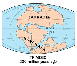
rocks, uplifted by the formation of Pangaea
Pangaea
Pangaea, Pangæa, or Pangea is hypothesized as a supercontinent that existed during the Paleozoic and Mesozoic eras about 250 million years ago, before the component continents were separated into their current configuration....
, eroded and were deposited into a body of fresh water
Water
Water is a chemical substance with the chemical formula H2O. A water molecule contains one oxygen and two hydrogen atoms connected by covalent bonds. Water is a liquid at ambient conditions, but it often co-exists on Earth with its solid state, ice, and gaseous state . Water also exists in a...
(probably a series of large river deltas). A huge freshwater lake - the Orcadian Lake
Orcadian Lakes
The Orcadian Lakes are a series of lakes which existed during the Devonian period in the region which is now northern Scotland, Orkney and Shetland. The sedimentary rocks they left behind have been studied since the 1830's...
- existed on the edges of the eroding mountains stretching from Shetland to the southern Moray Firth. The formations are extremely thick, up to 11,000 metres in places, and can be subdivided into three categories "Lower", "Middle", and "Upper" from oldest to youngest. As a result, the Old Red Sandstone is an important source of fish fossils and it was the object of intense geological studies in the 19th century. In Scotland these rocks are found predominantly in the Moray Firth basin and Orkney Archipelago, and along the southern margins of the Highland Boundary Fault.
Elsewhere volcanic activity, possibly as a result of the closing of the Iapetus Suture, created the Cheviot Hills
Cheviot Hills
The Cheviot Hills is a range of rolling hills straddling the England–Scotland border between Northumberland and the Scottish Borders.There is a broad split between the northern and the southern Cheviots...
, Ochil Hills
Ochil Hills
The Ochil Hills is a range of hills in Scotland north of the Forth valley bordered by the towns of Stirling, Alloa, Kinross and Perth. The only major roads crossing the hills pass through Glen Devon/Glen Eagles and Glenfarg, the latter now largely replaced except for local traffic by the M90...
, Sidlaw Hills
Sidlaw Hills
The Sidlaws are a range of hills of volcanic origin in the counties of Perthshire and Angus in Scotland that extend for 30 miles from Kinnoull Hill, near Perth, northeast to Forfar. Law is a Lowland Scots word of Old English origin meaning a hill which rises sharply from the surrounding land...
, parts of the Pentland Hills
Pentland Hills
The Pentland Hills are a range of hills to the south-west of Edinburgh, Scotland. The range is around 20 miles in length, and runs south west from Edinburgh towards Biggar and the upper Clydesdale.Some of the peaks include:* Scald Law...
and Scurdie Ness on the Angus
Angus
Angus is one of the 32 local government council areas of Scotland, a registration county and a lieutenancy area. The council area borders Aberdeenshire, Perth and Kinross and Dundee City...
coast.
Carboniferous period
During the CarboniferousCarboniferous
The Carboniferous is a geologic period and system that extends from the end of the Devonian Period, about 359.2 ± 2.5 Mya , to the beginning of the Permian Period, about 299.0 ± 0.8 Mya . The name is derived from the Latin word for coal, carbo. Carboniferous means "coal-bearing"...
period (359–299 Ma), Scotland lay close to the equator. Several changes in sea level occurred and the coal
Coal
Coal is a combustible black or brownish-black sedimentary rock usually occurring in rock strata in layers or veins called coal beds or coal seams. The harder forms, such as anthracite coal, can be regarded as metamorphic rock because of later exposure to elevated temperature and pressure...
deposits of Lanarkshire
Lanarkshire
Lanarkshire or the County of Lanark ) is a Lieutenancy area, registration county and former local government county in the central Lowlands of Scotland...
and West Lothian
West Lothian
West Lothian is one of the 32 unitary council areas in Scotland, and a Lieutenancy area. It borders the City of Edinburgh, Falkirk, North Lanarkshire, the Scottish Borders and South Lanarkshire....
and limestones of Fife
Fife
Fife is a council area and former county of Scotland. It is situated between the Firth of Tay and the Firth of Forth, with inland boundaries to Perth and Kinross and Clackmannanshire...
and Dunbar
Dunbar
Dunbar is a town in East Lothian on the southeast coast of Scotland, approximately 28 miles east of Edinburgh and 28 miles from the English Border at Berwick-upon-Tweed....
date from this time. There are oil shales
Oil shale geology
Oil shale geology is a branch of geologic sciences which studies the formation and composition of oil shales–fine-grained sedimentary rocks containing significant amounts of kerogen, and belonging to the group of sapropel fuels. Oil shale formation takes place in a number of depositional...
near Bathgate
Bathgate
Bathgate is a town in West Lothian, Scotland, on the M8 motorway west of Livingston. Nearby towns are Blackburn, Armadale, Whitburn, Livingston, and Linlithgow. Edinburgh Airport is away...
around which the 19th century oil-processing industry developed, and elsewhere in the Midland Valley there are ironstones and fire clay deposits that had significance in the early Industrial Revolution
Industrial Revolution
The Industrial Revolution was a period from the 18th to the 19th century where major changes in agriculture, manufacturing, mining, transportation, and technology had a profound effect on the social, economic and cultural conditions of the times...
. Fossil Grove
Fossil Grove
The Fossil Grove is located within Victoria Park, Glasgow, Scotland. It was discovered in 1887 and contains the fossilised stumps of eleven extinct Lepidodendron trees, which are sometimes described as "giant club mosses" but they may be more closely related to quillworts...
in Victoria Park, Glasgow
Victoria Park, Glasgow
-Description:Victoria Park is set in western Glasgow, adjacent to the districts of Scotstoun, Whiteinch, Jordanhill and Broomhill. The park was created and named for Queen Victoria's jubilee in 1886. The main entrances to the park are from Westland Drive, Victoria Park Drive North, and Balshagray...
contains the preserved remains of a Carboniferous forest. More volcanic activity formed Arthur's Seat
Arthur's Seat, Edinburgh
Arthur's Seat is the main peak of the group of hills which form most of Holyrood Park, described by Robert Louis Stevenson as "a hill for magnitude, a mountain in virtue of its bold design". It is situated in the centre of the city of Edinburgh, about a mile to the east of Edinburgh Castle...
and the Salisbury Crags in Edinburgh
Edinburgh
Edinburgh is the capital city of Scotland, the second largest city in Scotland, and the eighth most populous in the United Kingdom. The City of Edinburgh Council governs one of Scotland's 32 local government council areas. The council area includes urban Edinburgh and a rural area...
and the nearby Bathgate Hills
Bathgate
Bathgate is a town in West Lothian, Scotland, on the M8 motorway west of Livingston. Nearby towns are Blackburn, Armadale, Whitburn, Livingston, and Linlithgow. Edinburgh Airport is away...
.
Permian period
Pangaea
Pangaea, Pangæa, or Pangea is hypothesized as a supercontinent that existed during the Paleozoic and Mesozoic eras about 250 million years ago, before the component continents were separated into their current configuration....
in the Permian
Permian
The PermianThe term "Permian" was introduced into geology in 1841 by Sir Sir R. I. Murchison, president of the Geological Society of London, who identified typical strata in extensive Russian explorations undertaken with Edouard de Verneuil; Murchison asserted in 1841 that he named his "Permian...
(299–251 Ma), during which proto-Britain continued to drift northwards. Scotland's climate was arid at this time and some fossils of reptiles have been recovered. However, Permian sandstones are found in only a few places - principally in the south west, on the island of Arran, and on the Moray coast. Stone quarried from Hopeman
Hopeman
Hopeman is a seaside village in Moray, Scotland, on the coast of the Moray Firth, founded in 1805 to house and re-employ people displaced during the Highland clearances. The population is around 1 000 people in approximately 670 households.-The village:...
in Moray has been used in the National Museum
National Museum of Scotland
The National Museum of Scotland, Edinburgh, Scotland, was formed in 2006 with the merger of the Museum of Scotland, with collections relating to Scottish antiquities, culture and history, and the Royal Museum next door, with collections covering science and technology, natural history, and world...
and Scottish Parliament building
Scottish Parliament Building
The Scottish Parliament Building is the home of the Scottish Parliament at Holyrood, within the UNESCO World Heritage Site in central Edinburgh. Construction of the building commenced in June 1999 and the Members of the Scottish Parliament held their first debate in the new building on 7...
s in Edinburgh.
At the close of this period came the Permian–Triassic extinction event in which 96% of all marine
Marine biology
Marine biology is the scientific study of organisms in the ocean or other marine or brackish bodies of water. Given that in biology many phyla, families and genera have some species that live in the sea and others that live on land, marine biology classifies species based on the environment rather...
species
Species
In biology, a species is one of the basic units of biological classification and a taxonomic rank. A species is often defined as a group of organisms capable of interbreeding and producing fertile offspring. While in many cases this definition is adequate, more precise or differing measures are...
vanished and from which bio-diversity took 30 million years to recover.
Triassic period
During the TriassicTriassic
The Triassic is a geologic period and system that extends from about 250 to 200 Mya . As the first period of the Mesozoic Era, the Triassic follows the Permian and is followed by the Jurassic. Both the start and end of the Triassic are marked by major extinction events...
, (251–200 Ma) much of Scotland remained in desert conditions, with higher ground in the Highlands and Southern Uplands providing sediment to the surrounding basins via flash floods. This is the origin of sandstone outcrops near Dumfries
Dumfries
Dumfries is a market town and former royal burgh within the Dumfries and Galloway council area of Scotland. It is near the mouth of the River Nith into the Solway Firth. Dumfries was the county town of the former county of Dumfriesshire. Dumfries is nicknamed Queen of the South...
, Elgin
Elgin, Moray
Elgin is a former cathedral city and Royal Burgh in Moray, Scotland. It is the administrative and commercial centre for Moray. The town originated to the south of the River Lossie on the higher ground above the flood plain. Elgin is first documented in the Cartulary of Moray in 1190...
and the Isle of Arran
Isle of Arran
Arran or the Isle of Arran is the largest island in the Firth of Clyde, Scotland, and with an area of is the seventh largest Scottish island. It is in the unitary council area of North Ayrshire and the 2001 census had a resident population of 5,058...
. Towards the close of this period sea levels began to rise and climatic conditions became less arid.
Jurassic period
Jurassic
The Jurassic is a geologic period and system that extends from about Mya to Mya, that is, from the end of the Triassic to the beginning of the Cretaceous. The Jurassic constitutes the middle period of the Mesozoic era, also known as the age of reptiles. The start of the period is marked by...
(200–145 Ma) started, Pangaea
Pangaea
Pangaea, Pangæa, or Pangea is hypothesized as a supercontinent that existed during the Paleozoic and Mesozoic eras about 250 million years ago, before the component continents were separated into their current configuration....
began to break up into two continents, Gondwana
Gondwana
In paleogeography, Gondwana , originally Gondwanaland, was the southernmost of two supercontinents that later became parts of the Pangaea supercontinent. It existed from approximately 510 to 180 million years ago . Gondwana is believed to have sutured between ca. 570 and 510 Mya,...
and Laurasia
Laurasia
In paleogeography, Laurasia was the northernmost of two supercontinents that formed part of the Pangaea supercontinent from approximately...
, marking the beginning of the separation of Scotland and North America. Sea levels rose, as Britain and Ireland drifted on the Eurasian Plate
Eurasian Plate
The Eurasian Plate is a tectonic plate which includes most of the continent of Eurasia , with the notable exceptions of the Indian subcontinent, the Arabian subcontinent, and the area east of the Chersky Range in East Siberia...
to between 30° and 40° north. Most of northern and eastern Scotland including Orkney, Shetland and the Outer Hebrides remained above the advancing seas, but the south and south-west were inundated. There are only isolated sedimentary rock
Sedimentary rock
Sedimentary rock are types of rock that are formed by the deposition of material at the Earth's surface and within bodies of water. Sedimentation is the collective name for processes that cause mineral and/or organic particles to settle and accumulate or minerals to precipitate from a solution....
s remaining on land from this period, on the Sutherland
Sutherland
Sutherland is a registration county, lieutenancy area and historic administrative county of Scotland. It is now within the Highland local government area. In Gaelic the area is referred to according to its traditional areas: Dùthaich 'IcAoidh , Asainte , and Cataibh...
coast near Golspie and, forming the Great Estuarine Group
Great Estuarine Group
The Great Estuarine Group is a sequence of rocks which outcrop around the coast of the West Highlands of Scotland. Laid down in the Hebrides Basin during the middle Jurassic, they are the rough time equivalent of the Inferior and Great Oolite Groups found in southern England.This sequence of rocks...
, on Skye, Mull, Raasay
Raasay
Raasay is an island between the Isle of Skye and the mainland of Scotland. It is separated from Skye by the Sound of Raasay and from Applecross by the Inner Sound. It is most famous for being the birthplace of the poet Sorley MacLean, an important figure in the Scottish literary renaissance...
and Eigg
Eigg
Eigg is one of the Small Isles, in the Scottish Inner Hebrides. It lies to the south of the Skye and to the north of the Ardnamurchan peninsula. Eigg is long from north to south, and east to west. With an area of , it is the second largest of the Small Isles after Rùm.-Geography:The main...
. This period does however have considerable significance.
The burial of algae
Algae
Algae are a large and diverse group of simple, typically autotrophic organisms, ranging from unicellular to multicellular forms, such as the giant kelps that grow to 65 meters in length. They are photosynthetic like plants, and "simple" because their tissues are not organized into the many...
and bacteria below the mud of the sea floor during this time resulted in the formation of North Sea oil
North Sea oil
North Sea oil is a mixture of hydrocarbons, comprising liquid oil and natural gas, produced from oil reservoirs beneath the North Sea.In the oil industry, the term "North Sea" often includes areas such as the Norwegian Sea and the area known as "West of Shetland", "the Atlantic Frontier" or "the...
and natural gas
Natural gas
Natural gas is a naturally occurring gas mixture consisting primarily of methane, typically with 0–20% higher hydrocarbons . It is found associated with other hydrocarbon fuel, in coal beds, as methane clathrates, and is an important fuel source and a major feedstock for fertilizers.Most natural...
, much of it trapped in overlying sandstone by deposits formed as the seas fell to form the swamps and salty lakes and lagoons that were home to dinosaur
Dinosaur
Dinosaurs are a diverse group of animals of the clade and superorder Dinosauria. They were the dominant terrestrial vertebrates for over 160 million years, from the late Triassic period until the end of the Cretaceous , when the Cretaceous–Paleogene extinction event led to the extinction of...
s.
Cretaceous period
In the CretaceousCretaceous
The Cretaceous , derived from the Latin "creta" , usually abbreviated K for its German translation Kreide , is a geologic period and system from circa to million years ago. In the geologic timescale, the Cretaceous follows the Jurassic period and is followed by the Paleogene period of the...
, (146–65 Ma) Laurasia split into the continents of North America and Eurasia
Eurasia
Eurasia is a continent or supercontinent comprising the traditional continents of Europe and Asia ; covering about 52,990,000 km2 or about 10.6% of the Earth's surface located primarily in the eastern and northern hemispheres...
. Sea levels rose globally during this period and much of low-lying Scotland was covered in a layer of chalk
Chalk
Chalk is a soft, white, porous sedimentary rock, a form of limestone composed of the mineral calcite. Calcite is calcium carbonate or CaCO3. It forms under reasonably deep marine conditions from the gradual accumulation of minute calcite plates shed from micro-organisms called coccolithophores....
. Although large deposits of Cretaceous
Cretaceous
The Cretaceous , derived from the Latin "creta" , usually abbreviated K for its German translation Kreide , is a geologic period and system from circa to million years ago. In the geologic timescale, the Cretaceous follows the Jurassic period and is followed by the Paleogene period of the...
rocks were laid down over Scotland, these have not survived erosion except in a few places on the west coast such as Loch Aline
Loch Aline
Loch Aline is a small salt water loch home to fish, birds and game, located in Morvern, Lochaber, Scotland. Key features of interest are Kinlochaline Castle, Ardtornish Castle and the Ardtornish Estate located at its head....
in Morvern
Morvern
Morvern is a peninsula in south west Lochaber, on the west coast of Scotland. The name is derived from the Gaelic A' Mhorbhairne . The highest point is the summit of the Corbett Creach Bheinn which reaches in elevation....
where they form a part of the Inner Hebrides Group
Inner Hebrides Group
In geology, the Inner Hebrides Group is a lithostratigraphical division containing a range of rocks mainly of Upper Cretaceous age which occur around the west coast of the Scottish Highlands...
. At the end of this period the Cretaceous–Tertiary extinction event brought the age of dinosaurs to a close.
Paleogene period
In the early PaleogenePaleogene
The Paleogene is a geologic period and system that began 65.5 ± 0.3 and ended 23.03 ± 0.05 million years ago and comprises the first part of the Cenozoic Era...
period between 63 and 52 Ma, the last volcanic rocks in the British Isles were formed. As North America and Greenland
Greenland
Greenland is an autonomous country within the Kingdom of Denmark, located between the Arctic and Atlantic Oceans, east of the Canadian Arctic Archipelago. Though physiographically a part of the continent of North America, Greenland has been politically and culturally associated with Europe for...
, separated from Europe the Atlantic Ocean slowly formed. This led to a chain of volcanic sites west of mainland Scotland including on Skye, the Small Isles
Small Isles
The Small Isles are a small archipelago of islands in the Inner Hebrides, off the west coast of Scotland. They lie south of Skye and north of Mull and Ardnamurchan – the most westerly point of mainland Scotland.The four main islands are Canna, Rùm, Eigg and Muck...
and St. Kilda
St Kilda, Scotland
St Kilda is an isolated archipelago west-northwest of North Uist in the North Atlantic Ocean. It contains the westernmost islands of the Outer Hebrides of Scotland. The largest island is Hirta, whose sea cliffs are the highest in the United Kingdom and three other islands , were also used for...
, in the Firth of Clyde
Firth of Clyde
The Firth of Clyde forms a large area of coastal water, sheltered from the Atlantic Ocean by the Kintyre peninsula which encloses the outer firth in Argyll and Ayrshire, Scotland. The Kilbrannan Sound is a large arm of the Firth of Clyde, separating the Kintyre Peninsula from the Isle of Arran.At...
on Arran
Isle of Arran
Arran or the Isle of Arran is the largest island in the Firth of Clyde, Scotland, and with an area of is the seventh largest Scottish island. It is in the unitary council area of North Ayrshire and the 2001 census had a resident population of 5,058...
and Ailsa Craig
Ailsa Craig
Ailsa Craig is an island of 219.69 acres in the outer Firth of Clyde, Scotland where blue hone granite was quarried to make curling stones. "Ailsa" is pronounced "ale-sa", with the first syllable stressed...
and at Ardnamurchan
Ardnamurchan
Ardnamurchan is a peninsula in Lochaber, Highland, Scotland, noted for being very unspoilt and undisturbed. Its remoteness is accentuated by the main access route being a single track road for much of its length.-Geography:...
. Sea levels began to fall, and for the first time the general outline of the modern British Isles was revealed. At the beginning of this period the climate was sub-tropical and erosion was caused by chemical weathering, creating characteristic features of the Scottish landscape such as the topographical basin of the Howe of Alford
Alford, Aberdeenshire
Alford is a large village in Aberdeenshire, north-east Scotland, lying just south of the River Don. It lies within the Howe of Alford which occupies the middle reaches of the River Don....
near Aberdeen. By 35 Ma the landscape included beech
Beech
Beech is a genus of ten species of deciduous trees in the family Fagaceae, native to temperate Europe, Asia and North America.-Habit:...
, oak
Oak
An oak is a tree or shrub in the genus Quercus , of which about 600 species exist. "Oak" may also appear in the names of species in related genera, notably Lithocarpus...
, chestnut
Chestnut
Chestnut , some species called chinkapin or chinquapin, is a genus of eight or nine species of deciduous trees and shrubs in the beech family Fagaceae, native to temperate regions of the Northern Hemisphere. The name also refers to the edible nuts they produce.-Species:The chestnut belongs to the...
and sycamore
Sycamore Maple
Acer pseudoplatanus, the sycamore maple, is a species of maple native to central Europe and southwestern Asia, from France east to Ukraine, and south in mountains to northern Spain, northern Turkey, and the Caucasus. It is not related to other trees called sycamore or plane tree in the Platanus...
trees, along with grass
Grass
Grasses, or more technically graminoids, are monocotyledonous, usually herbaceous plants with narrow leaves growing from the base. They include the "true grasses", of the Poaceae family, as well as the sedges and the rushes . The true grasses include cereals, bamboo and the grasses of lawns ...
land.
Miocene and Pliocene epochs
In the Miocene
Miocene
The Miocene is a geological epoch of the Neogene Period and extends from about . The Miocene was named by Sir Charles Lyell. Its name comes from the Greek words and and means "less recent" because it has 18% fewer modern sea invertebrates than the Pliocene. The Miocene follows the Oligocene...
and Pliocene
Pliocene
The Pliocene Epoch is the period in the geologic timescale that extends from 5.332 million to 2.588 million years before present. It is the second and youngest epoch of the Neogene Period in the Cenozoic Era. The Pliocene follows the Miocene Epoch and is followed by the Pleistocene Epoch...
epochs further uplift and erosion occurred in the Highlands. Plant and animal types developed into their modern forms, and by about 2 million years ago the landscape would have been broadly recognisable today, with Scotland lying in its present position on the globe. As the Miocene progressed, temperatures dropped and remained similar to today's.
Pleistocene epoch
Ice age
An ice age or, more precisely, glacial age, is a generic geological period of long-term reduction in the temperature of the Earth's surface and atmosphere, resulting in the presence or expansion of continental ice sheets, polar ice sheets and alpine glaciers...
s shaped the land through glacial erosion, creating u-shaped valleys and depositing boulder clay
Boulder clay
Boulder clay, in geology, is a deposit of clay, often full of boulders, which is formed in and beneath glaciers and ice-sheets wherever they are found, but is in a special sense the typical deposit of the Glacial Period in northern Europe and North America...
s, especially on the western seaboard. The last major incursion of ice peaked about 18,000 years ago, leaving other remnant features such at the granite tors on the Cairngorm Mountain
Cairngorms
The Cairngorms are a mountain range in the eastern Highlands of Scotland closely associated with the mountain of the same name - Cairn Gorm.-Name:...
plateaux.
Holocene epoch
Over the last twelve thousand years the most significant new geological features have been the deposits of peat
Peat
Peat is an accumulation of partially decayed vegetation matter or histosol. Peat forms in wetland bogs, moors, muskegs, pocosins, mires, and peat swamp forests. Peat is harvested as an important source of fuel in certain parts of the world...
and the development of coastal alluvium. Post-glacial rises in sea level have been combined with isostatic
Isostasy
Isostasy is a term used in geology to refer to the state of gravitational equilibrium between the earth's lithosphere and asthenosphere such that the tectonic plates "float" at an elevation which depends on their thickness and density. This concept is invoked to explain how different topographic...
rises of the land resulting in a relative fall in sea level in most areas. In some places, such as Culbin in Moray, these changes in relative sea level have created a complex series of shorelines. A rare type of Scottish coastline found largely in the Hebrides
Hebrides
The Hebrides comprise a widespread and diverse archipelago off the west coast of Scotland. There are two main groups: the Inner and Outer Hebrides. These islands have a long history of occupation dating back to the Mesolithic and the culture of the residents has been affected by the successive...
consists of machair
Machair (geography)
The machair refers to a fertile low-lying grassy plain found on some of the north-west coastlines of Ireland and Scotland, in particular the Outer Hebrides...
habitat
Habitat
* Habitat , a place where a species lives and grows*Human habitat, a place where humans live, work or play** Space habitat, a space station intended as a permanent settlement...
, a low lying dune pasture land formed as the sea level dropped leaving a raised beach. In the present day, Scotland continues to move slowly north.
Geologists in Scotland

- James HuttonJames HuttonJames Hutton was a Scottish physician, geologist, naturalist, chemical manufacturer and experimental agriculturalist. He is considered the father of modern geology...
(1726–1797), the "father of modern geology," was born in Edinburgh. His Theory of the Earth, published in 1788 proposed the idea of a rock cycle in which weathered rocks form new sediments and that granites were of volcanic origin. At Glen TiltGlen TiltGlen Tilt is a glen in the extreme north of Perthshire, Scotland. Beginning at the confines of Aberdeenshire, it follows a South-westerly direction excepting for the last 4 miles, when it runs due south to Blair Atholl...
in the CairngormCairngormsThe Cairngorms are a mountain range in the eastern Highlands of Scotland closely associated with the mountain of the same name - Cairn Gorm.-Name:...
mountains he found graniteGraniteGranite is a common and widely occurring type of intrusive, felsic, igneous rock. Granite usually has a medium- to coarse-grained texture. Occasionally some individual crystals are larger than the groundmass, in which case the texture is known as porphyritic. A granitic rock with a porphyritic...
penetrating metamorphicMetamorphic rockMetamorphic rock is the transformation of an existing rock type, the protolith, in a process called metamorphism, which means "change in form". The protolith is subjected to heat and pressure causing profound physical and/or chemical change...
schistSchistThe schists constitute a group of medium-grade metamorphic rocks, chiefly notable for the preponderance of lamellar minerals such as micas, chlorite, talc, hornblende, graphite, and others. Quartz often occurs in drawn-out grains to such an extent that a particular form called quartz schist is...
s. This showed to him that granite formed from the cooling of molten rock, not precipitationPrecipitation (chemistry)Precipitation is the formation of a solid in a solution or inside anothersolid during a chemical reaction or by diffusion in a solid. When the reaction occurs in a liquid, the solid formed is called the precipitate, or when compacted by a centrifuge, a pellet. The liquid remaining above the solid...
out of water as the NeptunistsNeptunismNeptunism is a discredited and obsolete scientific theory of geology proposed by Abraham Gottlob Werner in the late 18th century that proposed rocks formed from the crystallisation of minerals in the early Earth's oceans....
of the time believed. This sight is said to have "filled him with delight". Regarding geological time scales he famously remarked "that we find no vestige of a beginning, no prospect of an end." - John PlayfairJohn PlayfairJohn Playfair FRSE, FRS was a Scottish scientist and mathematician, and a professor of natural philosophy at the University of Edinburgh. He is perhaps best known for his book Illustrations of the Huttonian Theory of the Earth , which summarized the work of James Hutton...
(1748–1819) from AngusAngusAngus is one of the 32 local government council areas of Scotland, a registration county and a lieutenancy area. The council area borders Aberdeenshire, Perth and Kinross and Dundee City...
was a mathematician who developed an interest in geology through his friendship with Hutton. His 1802 Illustrations of the Huttonian Theory of the Earth were influential in the latter's success. - John MacCullochJohn MacCullochJohn MacCulloch FRS was a Scottish geologist.-Biography:MacCulloch, descended from the MacCullochs of Nether Ardwell in Galloway, was born in Guernsey, his mother being a native of that island. Having displayed remarkable powers as a boy, he was sent to study medicine in the university of...
(1773–1835) was born in GuernseyGuernseyGuernsey, officially the Bailiwick of Guernsey is a British Crown dependency in the English Channel off the coast of Normandy.The Bailiwick, as a governing entity, embraces not only all 10 parishes on the Island of Guernsey, but also the islands of Herm, Jethou, Burhou, and Lihou and their islet...
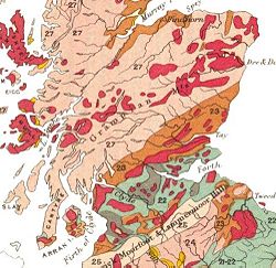
and like Hutton before him, studied medicine at Edinburgh University. A president of the Geological Society from 1815–17, he is best remembered for producing the first geological map of Scotland, published in 1836. 'Macculloch's Tree', a 40 feet (12.2 m) high fossil conifer in the Mull lava flows, is named after him.
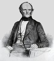
- Sir Charles LyellCharles LyellSir Charles Lyell, 1st Baronet, Kt FRS was a British lawyer and the foremost geologist of his day. He is best known as the author of Principles of Geology, which popularised James Hutton's concepts of uniformitarianism – the idea that the earth was shaped by slow-moving forces still in operation...
(1797–1875) was also from Angus and his Principles of GeologyPrinciples of GeologyPrinciples of Geology, being an attempt to explain the former changes of the Earth's surface, by reference to causes now in operation, is a book by the Scottish geologist Charles Lyell....
built on Hutton's ideas. Lyell's theory of uniformitarianismUniformitarianism (science)In the philosophy of naturalism, the uniformitarianism assumption is that the same natural laws and processes that operate in the universe now, have always operated in the universe in the past and apply everywhere in the universe. It has included the gradualistic concept that "the present is the...
and his interpretation of geologic change as the steady accumulation of minute changes over enormously long spans of time was a central theme in the Principles, and a powerful influence on the young Charles DarwinCharles DarwinCharles Robert Darwin FRS was an English naturalist. He established that all species of life have descended over time from common ancestry, and proposed the scientific theory that this branching pattern of evolution resulted from a process that he called natural selection.He published his theory...
. (Robert FitzRoyRobert FitzRoyVice-Admiral Robert FitzRoy RN achieved lasting fame as the captain of HMS Beagle during Charles Darwin's famous voyage, and as a pioneering meteorologist who made accurate weather forecasting a reality...
, captain of HMS BeagleHMS BeagleHMS Beagle was a Cherokee-class 10-gun brig-sloop of the Royal Navy. She was launched on 11 May 1820 from the Woolwich Dockyard on the River Thames, at a cost of £7,803. In July of that year she took part in a fleet review celebrating the coronation of King George IV of the United Kingdom in which...
, loaned Darwin a copy of Volume 1 of the first edition just before they set out on the 'Voyage of the Beagle'Second voyage of HMS BeagleThe second voyage of HMS Beagle, from 27 December 1831 to 2 October 1836, was the second survey expedition of HMS Beagle, under captain Robert FitzRoy who had taken over command of the ship on its first voyage after her previous captain committed suicide...
.) Lyell is buried in Westminster AbbeyWestminster AbbeyThe Collegiate Church of St Peter at Westminster, popularly known as Westminster Abbey, is a large, mainly Gothic church, in the City of Westminster, London, United Kingdom, located just to the west of the Palace of Westminster. It is the traditional place of coronation and burial site for English,...
.

- Sir Roderick MurchisonRoderick MurchisonSir Roderick Impey Murchison, 1st Baronet KCB DCL FRS FRSE FLS PRGS PBA MRIA was a Scottish geologist who first described and investigated the Silurian system.-Early life and work:...
(1792–1871) was born in Ross and Cromarty and served under WellesleyArthur Wellesley, 1st Duke of WellingtonField Marshal Arthur Wellesley, 1st Duke of Wellington, KG, GCB, GCH, PC, FRS , was an Irish-born British soldier and statesman, and one of the leading military and political figures of the 19th century...
in the Peninsular WarPeninsular WarThe Peninsular War was a war between France and the allied powers of Spain, the United Kingdom, and Portugal for control of the Iberian Peninsula during the Napoleonic Wars. The war began when French and Spanish armies crossed Spain and invaded Portugal in 1807. Then, in 1808, France turned on its...
. Knighted in 1846, his main achievements were the investigation of SilurianSilurianThe Silurian is a geologic period and system that extends from the end of the Ordovician Period, about 443.7 ± 1.5 Mya , to the beginning of the Devonian Period, about 416.0 ± 2.8 Mya . As with other geologic periods, the rock beds that define the period's start and end are well identified, but the...
rocks published as The Silurian System in 1839 and of PermianPermianThe PermianThe term "Permian" was introduced into geology in 1841 by Sir Sir R. I. Murchison, president of the Geological Society of London, who identified typical strata in extensive Russian explorations undertaken with Edouard de Verneuil; Murchison asserted in 1841 that he named his "Permian...
deposits in Russia. The Murchison craterMurchison (crater)Murchison is a lunar crater on the north edge of the Sinus Medii, named in honour of the geologist Sir Roderick Murchison. It shares a section of rim with the crater Pallas. To the southeast on the mare is the circular crater Chladni, and to the northeast is Ukert. Farther to the east is the...
on the MoonMoonThe Moon is Earth's only known natural satellite,There are a number of near-Earth asteroids including 3753 Cruithne that are co-orbital with Earth: their orbits bring them close to Earth for periods of time but then alter in the long term . These are quasi-satellites and not true moons. For more...
and at least fifteen geographical locations on Earth are named after him. - Hugh MillerHugh MillerHugh Miller was a self-taught Scottish geologist and writer, folklorist and an evangelical Christian.- Life and work :Born in Cromarty, he was educated in a parish school where he reportedly showed a love of reading. At 17 he was apprenticed to a stonemason, and his work in quarries, together with...
(1802–56) from CromartyCromartyThe Royal Burgh of Cromarty is a burgh in Ross and Cromarty, Highland, Scotland.-History:It was previously the county town of the former county of Cromartyshire...
was a stonemason and self-taught geologist. His 1841 publication The Old Red Sandstone became a bestseller. The fossils founds in these rocks were one of his fascinations, although his deep religious convictions led him to oppose the idea of biological evolution. - James CrollJames CrollJames Croll was a 19th century Scottish scientist who developed a theory of climate change based on changes in the Earth's orbit.-Life:...
(1821–90) developed a theory of climateClimateClimate encompasses the statistics of temperature, humidity, atmospheric pressure, wind, rainfall, atmospheric particle count and other meteorological elemental measurements in a given region over long periods...
change based on changes in the Earth's orbitPlanetary orbitIn physics, an orbit is the gravitationally curved path of an object around a point in space, for example the orbit of a planet around the center of a star system, such as the Solar System...
. Born near PerthPerth, ScotlandPerth is a town and former city and royal burgh in central Scotland. Located on the banks of the River Tay, it is the administrative centre of Perth and Kinross council area and the historic county town of Perthshire...
, he was self-educated and his interest in science led to his becoming appointed as a janitor in the museum at the Andersonian College and Museum, Glasgow in 1859. His 1864 paper On the Physical Cause of the Changes of Climate during Glacial Epochs led to a position in the EdinburghEdinburghEdinburgh is the capital city of Scotland, the second largest city in Scotland, and the eighth most populous in the United Kingdom. The City of Edinburgh Council governs one of Scotland's 32 local government council areas. The council area includes urban Edinburgh and a rural area...
office of the Geological Survey of ScotlandBritish Geological SurveyThe British Geological Survey is a partly publicly funded body which aims to advance geoscientific knowledge of the United Kingdom landmass and its continental shelf by means of systematic surveying, monitoring and research. The BGS headquarters are in Keyworth, Nottinghamshire, but other centres...
, as keeper of maps and correspondence, where Sir Archibald GeikieArchibald GeikieSir Archibald Geikie, OM, KCB, PRS, FRSE , was a Scottish geologist and writer.-Early life:Geikie was born in Edinburgh in 1835, the eldest son of musician and music critic James Stuart Geikie...
, encouraged his research. He was eventually to become a Fellow of the Royal SocietyRoyal SocietyThe Royal Society of London for Improving Natural Knowledge, known simply as the Royal Society, is a learned society for science, and is possibly the oldest such society in existence. Founded in November 1660, it was granted a Royal Charter by King Charles II as the "Royal Society of London"...
. - Sir Archibald GeikieArchibald GeikieSir Archibald Geikie, OM, KCB, PRS, FRSE , was a Scottish geologist and writer.-Early life:Geikie was born in Edinburgh in 1835, the eldest son of musician and music critic James Stuart Geikie...
(1835–1924) was the first to recognise that there had been multiple glaciations, and his 1863 paper On the glacial drift of Scotland was a landmark in the emergent theories of glaciation. He became Director-General of the Geological Survey of the United Kingdom in 1888 and was also well-known for his work on vulcanismVolcanismVolcanism is the phenomenon connected with volcanoes and volcanic activity. It includes all phenomena resulting from and causing magma within the crust or mantle of a planet to rise through the crust and form volcanic rocks on the surface....
. - Arthur HolmesArthur HolmesArthur Holmes was a British geologist. As a child he lived in Low Fell, Gateshead and attended the Gateshead Higher Grade School .-Age of the earth:...
(1890–1965) was born in England and became Regius Professor of Geology at the University of EdinburghUniversity of EdinburghThe University of Edinburgh, founded in 1583, is a public research university located in Edinburgh, the capital of Scotland, and a UNESCO World Heritage Site. The university is deeply embedded in the fabric of the city, with many of the buildings in the historic Old Town belonging to the university...
in 1943. His magnum opus was Principles of Physical Geology, first published in 1944, in which he proposed the idea that slow moving convection currents in the Earth's mantle created 'continental drift' as it was then called. He also pioneered the discipline of geochronologyGeochronologyGeochronology is the science of determining the age of rocks, fossils, and sediments, within a certain degree of uncertainty inherent to the method used. A variety of dating methods are used by geologists to achieve this, and schemes of classification and terminology have been proposed...
. He lived long enough to see the theory of plate tectonicsPlate tectonicsPlate tectonics is a scientific theory that describes the large scale motions of Earth's lithosphere...
become widely accepted, and he is regarded as one of the most influential geologists of the 20th century.
Important sites
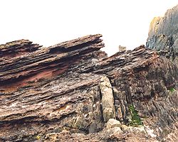
- Siccar PointSiccar PointSiccar Point is a rocky promontory in the county of Berwickshire on the east coast of Scotland.It is famous in the history of geology for Hutton's Unconformity found in 1788, which James Hutton regarded as conclusive proof of his uniformitarian theory of geological development.-History:Siccar...
, BerwickshireBerwickshireBerwickshire or the County of Berwick is a registration county, a committee area of the Scottish Borders Council, and a lieutenancy area of Scotland, on the border with England. The town after which it is named—Berwick-upon-Tweed—was lost by Scotland to England in 1482...
is world famous as one of the sites that proved Hutton's views about the immense age of the Earth. Here Silurian rocks have been tilted almost to the vertical. Younger Devonian rocks lie unconformablyUnconformityAn unconformity is a buried erosion surface separating two rock masses or strata of different ages, indicating that sediment deposition was not continuous. In general, the older layer was exposed to erosion for an interval of time before deposition of the younger, but the term is used to describe...
over the top of them, dipping gently, indicating that an enormous span of time must have passed between the creation of the two beds. When Hutton and James Hall visited the site in 1788 their companion Playfair wrote:
- The Moine ThrustMoine Thrust BeltThe Moine Thrust Belt is a linear geological feature in the Scottish Highlands which runs from Loch Eriboll on the north coast 190 km south-west to the Sleat peninsula on the Isle of Skye...
in AssyntAssyntAssynt is a civil parish in west Sutherland, Highland, Scotland – north of Ullapool.It is famous for its landscape and its remarkable mountains...
is one of the most studied geological features in the world. Its discovery in the 1880s was a milestone in the history of geology as it was one of the first thrust belts in the world to be identified. Investigations by John HorneJohn HorneJohn Horne was a Scottish geologist. He was elected a Fellow of the Royal Society in 1900. He was a pupil of Ben Peach....
and Benjamin PeachBen PeachBenjamin Neeve Peach, FRS was a British geologist.He was born at Gorran Haven in Cornwall to Charles William Peach, an amateur British naturalist and geologist. Ben was educated at the Royal School of Mines in London and then joined the Geological Survey in 1862 as a geologist, moving to the...
resolved a dispute between Murchison and Geikie on the one hand and James Nicol and Charles LapworthCharles LapworthCharles Lapworth was an English geologist.-Biography:He was born at Faringdon in Berkshire and educated as a teacher at the Culham Diocesan Training College near Abingdon, Oxfordshire. He moved to the Scottish border region, where he investigated the previously little-known fossil fauna of the area...
on the other. The latter believed that older Moine rocksMoine SupergroupThe Moine Supergroup is a sequence of Neoproterozoic metamorphic rocks that form the dominant outcrop of the Scottish Highlands between the Moine Thrust Belt to the northwest and the Great Glen Fault to the southeast. The sequence is metasedimentary in nature and was metamorphosed and deformed in a...
lay on top of younger Cambrian rocks at Knockan CragKnockan CragKnockan Crag is a line of cliffs in Assynt, Scotland north of Ullapool. The name is an anglicisation of the Gaelic Creag a' Chnocain meaning 'crag of the small hill'....
, and Horne and Peach's work confirmed this in their classic paper The Geological Structure of the Northwest Highlands of Scotland, which was published in 1907. A statue to these two pioneers of fieldwork was erected at InchnadamphInchnadamphInchnadamph is a hamlet in Assynt, Sutherland, Scotland. The name is an anglicisation of the Gaelic name Innis nan Damh meaning 'meadow of the stags'...
near the hotel there which played a prominent part in the annals of early geology. This area is at the heart of the 'North West Highlands Geopark'. - Lapworth also had a prominent role to play in the fame of Dob's LinnDob's LinnDob's Linn, near Moffat, Scotland, is the location of the Global Boundary Stratotype Section and Point which marks the boundary between the Ordovician and Silurian periods, and marks the base of Llandovery epoch, on the geologic time scale...
, a small gorge in the Scottish BordersScottish BordersThe Scottish Borders is one of 32 local government council areas of Scotland. It is bordered by Dumfries and Galloway in the west, South Lanarkshire and West Lothian in the north west, City of Edinburgh, East Lothian, Midlothian to the north; and the non-metropolitan counties of Northumberland...
, which contains the 'golden spike' (i.e. the official international boundary or stratotype) between the Ordovician and Silurian periods. Lapworth's work in this area, especially his examination of the complex stratigraphyStratigraphyStratigraphy, a branch of geology, studies rock layers and layering . It is primarily used in the study of sedimentary and layered volcanic rocks....
of the Silurian rocks by comparing fossil graptoliteGraptoliteGraptolithina is a class in the animal phylum Hemichordata, the members of which are known as Graptolites. Graptolites are fossil colonial animals known chiefly from the Upper Cambrian through the Lower Carboniferous...
s, was crucial in to the early understanding of these epochs.

- The Skye CuillinCuillinThis article is about the Cuillin of Skye. See Rùm for the Cuillin of Rùm.The Cuillin are a range of rocky mountains located on the Isle of Skye in Scotland. The true Cuillin are also known as the Black Cuillin to distinguish them from the Red Hills across Glen Sligachan...
mountains provide classic examples of glacial topography and were the subject of an early published account by James ForbesJames David ForbesJames David Forbes was a Scottish physicist and glaciologist who worked extensively on the conduction of heat and seismology. Forbes was a resident of Edinburgh for most of his life, educated at the University and a professor there from 1833 until he became principal of the United College of St...
in 1846 (who had become a fellow of the Royal Society of EdinburghRoyal Society of EdinburghThe Royal Society of Edinburgh is Scotland's national academy of science and letters. It is a registered charity, operating on a wholly independent and non-party-political basis and providing public benefit throughout Scotland...
aged only nineteen). He partnered Louis AgassizLouis AgassizJean Louis Rodolphe Agassiz was a Swiss paleontologist, glaciologist, geologist and a prominent innovator in the study of the Earth's natural history. He grew up in Switzerland and became a professor of natural history at University of Neuchâtel...
on his trip to Scotland in 1840 and although they subsequently argued, Forbes went on to publish other important papers on Alpine glaciers. - In 1904 Alfred Harker published The Tertiary Igneous Rocks of Skye, the first detailed scientific study of an extinct volcano.
- In the hills to the north of the village of StrontianStrontianStrontian is the main village in Sunart, an area in western Lochaber, Highland, Scotland, on the A861 road. It lies on the north shore of Loch Sunart, close to the head of the loch...
the mineral strontianiteStrontianiteStrontianite is an important raw material for the extraction of strontium. It is a rare carbonate mineral and one of only a few strontium minerals...
was discovered, from which the element strontiumStrontiumStrontium is a chemical element with the symbol Sr and the atomic number 38. An alkaline earth metal, strontium is a soft silver-white or yellowish metallic element that is highly reactive chemically. The metal turns yellow when exposed to air. It occurs naturally in the minerals celestine and...
was first isolated by Sir Humphry DavyHumphry DavySir Humphry Davy, 1st Baronet FRS MRIA was a British chemist and inventor. He is probably best remembered today for his discoveries of several alkali and alkaline earth metals, as well as contributions to the discoveries of the elemental nature of chlorine and iodine...
in 1808. - The island of StaffaStaffaStaffa from the Old Norse for stave or pillar island, is an island of the Inner Hebrides in Argyll and Bute, Scotland. The Vikings gave it this name as its columnar basalt reminded them of their houses, which were built from vertically placed tree-logs....
, contains Fingal's CaveFingal's CaveFingal's Cave is a sea cave on the uninhabited island of Staffa, in the Inner Hebrides of Scotland, part of a National Nature Reserve owned by the National Trust for Scotland. It is formed entirely from hexagonally jointed basalt columns, similar in structure to the Giant's Causeway in Northern...
made up of massive rectangular columns of TertiaryTertiaryThe Tertiary is a deprecated term for a geologic period 65 million to 2.6 million years ago. The Tertiary covered the time span between the superseded Secondary period and the Quaternary...
basalt and Mackinnon's Cave, one of the longest sea caves in the world. - The MunroMunroA Munro is a mountain in Scotland with a height over . They are named after Sir Hugh Munro, 4th Baronet , who produced the first list of such hills, known as Munros Tables, in 1891. A Munro top is a summit over 3,000 ft which is not regarded as a separate mountain...
SchiehallionSchiehallionSchiehallion is a prominent mountain in Perth and Kinross, Scotland. Schiehallion has a rich botanical life, interesting archaeology, and a unique place in scientific history for an 18th-century experiment in 'weighing the world'...
's isolated position and regular shape led Nevil MaskelyneNevil MaskelyneThe Reverend Dr Nevil Maskelyne FRS was the fifth English Astronomer Royal. He held the office from 1765 to 1811.-Biography:...
to use the deflection caused by the massMassMass can be defined as a quantitive measure of the resistance an object has to change in its velocity.In physics, mass commonly refers to any of the following three properties of matter, which have been shown experimentally to be equivalent:...
of the mountain to estimate the mass of the EarthEarthEarth is the third planet from the Sun, and the densest and fifth-largest of the eight planets in the Solar System. It is also the largest of the Solar System's four terrestrial planets...
in a ground-breaking experiment carried out in 1774. Following Maskelyne's survey, Schiehallion became the first mountain to be mapped using contour lineContour lineA contour line of a function of two variables is a curve along which the function has a constant value. In cartography, a contour line joins points of equal elevation above a given level, such as mean sea level...
s. - The village of Rhynie in AberdeenshireAberdeenshireAberdeenshire is one of the 32 unitary council areas in Scotland and a lieutenancy area.The present day Aberdeenshire council area does not include the City of Aberdeen, now a separate council area, from which its name derives. Together, the modern council area and the city formed historic...
is the site of an important sedimentary deposit - Rhynie chertRhynie chertThe Rhynie chert is an Early Devonian sedimentary deposit exhibiting extraordinary fossil detail or completeness . It is exposed near the village of Rhynie, Aberdeenshire, Scotland; a second unit, the Windyfield chert, is located some 700 m away...
. The bulk of this fossil bed consists of primitive plantPlantPlants are living organisms belonging to the kingdom Plantae. Precise definitions of the kingdom vary, but as the term is used here, plants include familiar organisms such as trees, flowers, herbs, bushes, grasses, vines, ferns, mosses, and green algae. The group is also called green plants or...
s that had water-conducting cellsXylemXylem is one of the two types of transport tissue in vascular plants. . The word xylem is derived from the Classical Greek word ξυλον , meaning "wood"; the best-known xylem tissue is wood, though it is found throughout the plant...
and sporangia but no leavesLeafA leaf is an organ of a vascular plant, as defined in botanical terms, and in particular in plant morphology. Foliage is a mass noun that refers to leaves as a feature of plants....
, along with arthropodArthropodAn arthropod is an invertebrate animal having an exoskeleton , a segmented body, and jointed appendages. Arthropods are members of the phylum Arthropoda , and include the insects, arachnids, crustaceans, and others...
s: Collembola, OpilionesOpilionesOpiliones are an order of arachnids commonly known as harvestmen. , over 6,400 species of harvestmen have been discovered worldwide, although the real number of extant species may exceed 10,000. The order Opiliones can be divided into four suborders: Cyphophthalmi, Eupnoi, Dyspnoi and Laniatores...
(harvestmen), pseudoscorpionPseudoscorpionA pseudoscorpion, , is an arachnid belonging to the order Pseudoscorpionida, also known as Pseudoscorpiones or Chelonethida....
s and the extinct, spider-like Trigonotarbids. This fossil bed is remarkable for two reasons. Firstly, the age of the find (early DevonianDevonianThe Devonian is a geologic period and system of the Paleozoic Era spanning from the end of the Silurian Period, about 416.0 ± 2.8 Mya , to the beginning of the Carboniferous Period, about 359.2 ± 2.5 Mya...
circa 410 Ma) makes this one of the earliest sites anywhere containing terrestrial fossils, coinciding with the first stages of the colonisation of land by plants and animalAnimalAnimals are a major group of multicellular, eukaryotic organisms of the kingdom Animalia or Metazoa. Their body plan eventually becomes fixed as they develop, although some undergo a process of metamorphosis later on in their life. Most animals are motile, meaning they can move spontaneously and...
s. Secondly, these chertChertChert is a fine-grained silica-rich microcrystalline, cryptocrystalline or microfibrous sedimentary rock that may contain small fossils. It varies greatly in color , but most often manifests as gray, brown, grayish brown and light green to rusty red; its color is an expression of trace elements...
s are famous for their exceptional state of ultrastructuralUltrastructureUltrastructure is the detailed structure of a biological specimen, such as a cell, tissue, or organ, that can be observed by electron microscopy...
preservation, with individual cell walls easily visible in polished specimens. For example, stomata have been counted and ligninLigninLignin or lignen is a complex chemical compound most commonly derived from wood, and an integral part of the secondary cell walls of plants and some algae. The term was introduced in 1819 by de Candolle and is derived from the Latin word lignum, meaning wood...
remnants detected in the plant material. - A disused quarry at East Kirkton in the Bathgate HillsBathgateBathgate is a town in West Lothian, Scotland, on the M8 motorway west of Livingston. Nearby towns are Blackburn, Armadale, Whitburn, Livingston, and Linlithgow. Edinburgh Airport is away...
is the location where the Carboniferous fossil of Westlothiana lizziaeWestlothianaWestlothiana lizziae was a reptile-like amphibian or possibly early reptile that bore a superficial resemblance to modern-day lizards. It lived during the Carboniferous period, about 350 million years ago. The type specimen was discovered in East Kirkton Quarry, Bathgate, Scotland, in 1984, and was...
(aka 'Lizzie') was found in 1984. This lizard is one of the earliest known ancestors of the reptileReptileReptiles are members of a class of air-breathing, ectothermic vertebrates which are characterized by laying shelled eggs , and having skin covered in scales and/or scutes. They are tetrapods, either having four limbs or being descended from four-limbed ancestors...
s. The specimen was purchased in part by public subscription and is now on display in the National Museum of ScotlandNational Museum of ScotlandThe National Museum of Scotland, Edinburgh, Scotland, was formed in 2006 with the merger of the Museum of Scotland, with collections relating to Scottish antiquities, culture and history, and the Royal Museum next door, with collections covering science and technology, natural history, and world...
. The site was originally discovered in the early 19th century and has also provided fossil eurypteridEurypteridEurypterids are an extinct group of arthropods related to arachnids which include the largest known arthropods that ever lived. They are members of the extinct order Eurypterida ; which is the most diverse Paleozoic chelicerate order in terms of species...
s, sharkSharkSharks are a type of fish with a full cartilaginous skeleton and a highly streamlined body. The earliest known sharks date from more than 420 million years ago....
s and a variety of primitive acanthodian fish. - In 2008 the ejected material from a meteoriteMeteoriteA meteorite is a natural object originating in outer space that survives impact with the Earth's surface. Meteorites can be big or small. Most meteorites derive from small astronomical objects called meteoroids, but they are also sometimes produced by impacts of asteroids...
impact crater was discovered near UllapoolUllapool bolide impactEvidence for a bolide impact centered on Ullapool was published by a combined team of scientists from the University of Oxford and the University of Aberdeen, in March 2008. The evidence is centred on Ullapool, a harbour town on Loch Broom in the Ross and Cromarty district of the Highland council...
in Wester Ross. Preserved within sedimentary layers of sandstone, this is the largest known bolide impact from what are now the British IslesBritish IslesThe British Isles are a group of islands off the northwest coast of continental Europe that include the islands of Great Britain and Ireland and over six thousand smaller isles. There are two sovereign states located on the islands: the United Kingdom of Great Britain and Northern Ireland and...
.
See also
- Geography of ScotlandGeography of ScotlandThe geography of Scotland is highly varied, from rural lowlands to barren uplands, and from large cities to uninhabited islands. Located in north-west Europe, Scotland comprises the northern one third of the island of Great Britain...
- Geology of the British IslesGeology of the British IslesGreat Britain shows a rich variety of landscape across the constituent countries of England, Wales and Scotland. Landforms and rocks of all geological ages are represented, from Precambrian onwards.- Seismographical results :...
- Geology of Ireland
- Geology of EnglandGeology of EnglandThe Geology of England is mainly sedimentary. The youngest rocks are in the south east around London, progressing in age in a north westerly direction. The Tees-Exe line marks the division between younger, softer and low-lying rocks in the south east and older, harder, and generally a higher relief...
- Geology of WalesGeology of WalesWales is a peninsula in the south-west of the island of Great Britain. The entire area of Wales is about . It is about north-south and east-west. Wales is bordered by England to the east and by sea in the other three directions: the Bristol Channel to the south, St George's Channel to the west,...
- British Geological SurveyBritish Geological SurveyThe British Geological Survey is a partly publicly funded body which aims to advance geoscientific knowledge of the United Kingdom landmass and its continental shelf by means of systematic surveying, monitoring and research. The BGS headquarters are in Keyworth, Nottinghamshire, but other centres...
- Geologic timescale
- Coal MeasuresCoal MeasuresThe Coal Measures is a lithostratigraphical term for the coal-bearing part of the Upper Carboniferous System. It represents the remains of fluvio-deltaic sediment, and consists mainly of clastic rocks interstratified with the beds of coal...
- Old Red SandstoneOld Red SandstoneThe Old Red Sandstone is a British rock formation of considerable importance to early paleontology. For convenience the short version of the term, 'ORS' is often used in literature on the subject.-Sedimentology:...
- New Red SandstoneNew Red SandstoneThe New Red Sandstone is a chiefly British geological term for the beds of red sandstone and associated rocks laid down throughout the Permian to the beginning of the Triassic that underlie the Jurassic Lias; the term distinguishes it from the Old Red Sandstone which is largely Devonian in...
- Geology of OrkneyGeology of OrkneyThe geology of the Orkney archipelago in northern Scotland is dominated by the Devonian age Old Red Sandstone . In the southwestern part of Mainland, this sequence can be seen to rest unconformably on a Moinian type metamorphic basement....