

Geology of Wales
Encyclopedia
Wales
is a peninsula
in the south-west of the island of Great Britain
. The entire area of Wales is about 20779 km² (8,022.8 sq mi). It is about 274 km (170.3 mi) north
-south
and 97 km (60.3 mi) east
-west
. Wales is bordered by England
to the east and by sea in the other three directions: the Bristol Channel
to the south, St George's Channel
to the west, and the Irish Sea
to the north. Together, Wales has over 1200 km (745.6 mi) of coastline. There are several islands off the Welsh mainland, the largest being Ynys Môn
(Anglesey) in the north west.
Wales is mountain
ous, particularly in the north and central regions. The mountains were shaped during the last ice age
, the Devensian glaciation. The highest mountains in Wales are in Snowdonia
(Eryri), and include Snowdon
(Yr Wyddfa), which, at 1085 m (3,560 ft) is the highest peak in Wales. The Brecon Beacons
(Bannau Brycheiniog) are in the south and are joined by the Cambrian Mountains
in mid-Wales, the latter name being given to the earliest geological period of the Paleozoic
era, the Cambrian
.
In the mid-19th century, two prominent geologists, Roderick Murchison
and Adam Sedgwick
used their studies of the geology of Wales to establish certain principles of stratigraphy
and palaeontology. After much dispute, the next two periods of the Paleozoic era, the Ordovician
and Silurian
, were named after ancient Celtic tribes from this area.
 Avalonia
was an ancient microcontinent or terrane
whose history formed much of the older rocks of Western Europe. The name is derived from the Avalon Peninsula
in Newfoundland. Wales was entirely contained within the Avalonian block, and shares its tectonic chronology.
In the early Cambrian
, the supercontinent
Pannotia
broke up and Avalonia drifted off northwards from Gondwana
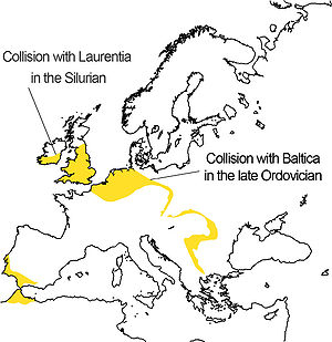
. This independent movement of Avalonia started from a latitude of about 60° South. The eastern end of Avalonia collided with Baltica
, a continental plate occupying the latitudes from about 30°S to 55°S, as the latter slowly rotated anticlockwise towards it. This happened at the end of the Ordovician
and during the early Silurian
.
In the late Silurian
and lower Devonian
, the combined Baltica and Avalonia collided progressively, with Laurentia
, beginning with the long extremity of Avalonia which is now attached to America. The result of this was the formation of Euramerica
. At the completion of this stage, the site of Britain was at 30°S and Nova Scotia at about 45°S. This collision is represented by the Caledonian
folding or in North America as an early phase in the Acadian orogeny
.
In the Permian
, the new continent and another terrane, Armorica
which included Iberia, drifted in from Gondwana, trapping Avalonia between it and the continent so adding Iberia/Armorica to Euramerica. This was followed up by the arrival of Gondwana. The effects of these collisions are seen in Europe as the Variscan
folding. In North America it shows as later phases of the Acadian orogeny. This was happening at around the Equator during the later Carboniferous
, forming Pangaea
in such a way that Avalonia was near its centre but partially flooded by shallow sea.
In the Jurassic
, Pangaea split into Laurasia
and Gondwana, with Avalonia as part of Laurasia. In the Cretaceous
, Laurasia broke up into North America
and Eurasia
with Avalonia split between them.
- The Snowdonia National Park may be divided into four areas. The northernmost area includes (west to east): Moel Hebog
, Mynydd Mawr
and the Nantlle Ridge
; the Snowdon massif
; the Glyderau
, and the Carneddau
. These last three groups are the highest mountains in Wales
, and include all Wales' 3000-foot mountains
. The second area includes peaks such as Moel Siabod
, Cnicht
, the Moelwynion
, and the mountains around Blaenau Ffestiniog
. Together these two areas approximate to the Snowdonia
(Eryri) of Welsh tradition.
The third area includes the Rhinogydd
in the west as well as the Arenig
and the Migneint
(this last being an area of bog). The southernmost area includes Cadair Idris
, the Tarren range, and the Aran group, including Aran Fawddwy
, the highest mountain in Wales south of Snowdon. These two areas, in Meirionnydd
, are within the national park but do not form part of the area of Snowdonia proper.
Snowdon and its vicinity form a syncline
of Ordovician
rocks which are partly volcanic. Snowdon itself is largely formed of volcanic ash (tuff
) with some sedimentary rock and igneous intrusion
s. Cadair Idris is also largely formed of Ordovician igneous rocks. The Harlech Dome
, which includes the Rhinogydd, is formed of Cambrian
gritstones and mudstones.
Elsewhere in north Wales, Pre-Cambrian rocks occur in Anglesey
, while the Berwyn range
consists mainly of Ordovician sedimentary strata. Carboniferous Limestone
occurs north of Llangollen
and the Coal Measures
near Wrexham
.
Ordovician and Silurian sediments folded in the Caledonian Orogeny
cover much of Wales, north and south.
South Wales
has a written record of geological interest going back to the 12th century when Giraldus Cambrensis
noted pyritous shale
s near Newport
. George Owen in 1603 correctly identified the stratigraphic relationship between the Carboniferous Limestone and the Coal Measures. Some of the first published representations of fossil
s were those of fossil plants taken from coal measures near Neath
(Gibson late 17th century). Adam Sedgwick
and Roderick Murchison
did fundamental work on Old Red Sandstone
and the underlying rocks.
Several successive periods are represented. Pembrokeshire
has outcrops of both Pre-Cambrian and Cambrian
rocks. A notable feature of the Ordovician
system is a major downwarp
known as the Welsh geosyncline. Silurian
rocks, largely mudstones and siltstones, are widely distributed in South Wales and are well displayed on the Cardiganshire
coast. Carboniferous Limestone outcrops occur in south Pembrokeshire
, Gower
, the Vale of Glamorgan
and the north and east sides of the coalfield
.
One of the geological rarities of South Wales
is the coastline of Ogmore-by-Sea
and Southerndown
. Its cliff
s are composed of Sutton stone; a very rare freestone
that is a banded mixture of lias
limestone
which contains large elements of Carboniferous
limestone. Sutton stone has always been highly regarded: as well as being used in construction throughout the Vale of Glamorgan, it was also shipped over the Bristol Channel
to North Devon
and North Cornwall
which are both deficient in limestone.
A major geological feature of the Upper Carboniferous sub-period in South Wales is the South Wales coalfield
syncline
. The rocks comprising this important area were laid down during the Westphalian Geological Series (or epoch
) approximately 314-308 million years ago (Ma), when climatic conditions were equatorial. This Westphalian succession includes a sequence with a thickness of more than 1800 m in the west. The Coal Measures were laid down on a low-lying waterlogged plain with peat mires immediately south of an ancient geological feature known as the Wales-London-Brabant High.
The Brecon Beacons
are a mountain range located in the south-east of Wales, forming the nucleus of the Brecon Beacons National Park (Parc Cenedlaethol Bannau Brycheiniog). The range consists of the mountains to the south of Brecon. The highest of these is Pen y Fan (886 m); other notable summits include Corn Du (873 m), Cribyn (795 m), and Fan y Bîg (719 m). These summits form a long ridge which forms a horseshoe around the head of the Taf Fechan river to the south-east, with long parallel spurs extending to the north-east. The Brecon Beacons are made of Devonian
Old Red Sandstone
.
Cefn Bryn
(Ridge Hill) is a 5 miles (8 km) long Old Red Sandstone ridge
in the heart of the Gower Peninsula
. The highest point on the ridge (186m) is the second highest point in Gower. The grassland on the ridge is known as Cefn Bryn Common.
Cefn-cerrig Road near Cefn-cerrig Farm, Llandovery
, is the location of the Global Boundary Stratotype Section and Point
(GSSP) which marks the boundary between the Aeronian and Telychian stages of the Silurian
period on the geologic time scale
. The GSSP was ratified in 1984.
The boundary is defined as a point immediately above the highest record of the brachiopod
Eocoelia intermedia and below the first appearance
of the succeeding species Eocoelia curtisi. The boundary also corresponds to the incoming of the acritarch
s Deunffia monospinosa, Domasia bispinosa and Pterospermella. The section, part of the Wormwood Formation, is sandstone
and siltstone
.
Trefawr Track
, a forestry road north of Cwm-coed-aeron Farm, Llandovery
, is the location of the Global Boundary Stratotype Section and Point
(GSSP) which marks the boundary between the Rhuddanian and Aeronian stages of the Silurian
period on the geologic time scale
. The GSSP was ratified in 1984.
The boundary is defined as the first appearance
of the graptolite
Monograptus austerus sequens (the base of the Monograptus triangulatus biozone). The section is primarily mudstone
, which yields an abundance of shelly fauna
s. The graptolite Diplograptus elongatus occurs immediately below the boundary.
Wales
Wales is a country that is part of the United Kingdom and the island of Great Britain, bordered by England to its east and the Atlantic Ocean and Irish Sea to its west. It has a population of three million, and a total area of 20,779 km²...
is a peninsula
Peninsula
A peninsula is a piece of land that is bordered by water on three sides but connected to mainland. In many Germanic and Celtic languages and also in Baltic, Slavic and Hungarian, peninsulas are called "half-islands"....
in the south-west of the island of Great Britain
Great Britain
Great Britain or Britain is an island situated to the northwest of Continental Europe. It is the ninth largest island in the world, and the largest European island, as well as the largest of the British Isles...
. The entire area of Wales is about 20779 km² (8,022.8 sq mi). It is about 274 km (170.3 mi) north
North
North is a noun, adjective, or adverb indicating direction or geography.North is one of the four cardinal directions or compass points. It is the opposite of south and is perpendicular to east and west.By convention, the top side of a map is north....
-south
South
South is a noun, adjective, or adverb indicating direction or geography.South is one of the four cardinal directions or compass points. It is the opposite of north and is perpendicular to east and west.By convention, the bottom side of a map is south....
and 97 km (60.3 mi) east
East
East is a noun, adjective, or adverb indicating direction or geography.East is one of the four cardinal directions or compass points. It is the opposite of west and is perpendicular to north and south.By convention, the right side of a map is east....
-west
West
West is a noun, adjective, or adverb indicating direction or geography.West is one of the four cardinal directions or compass points. It is the opposite of east and is perpendicular to north and south.By convention, the left side of a map is west....
. Wales is bordered by England
England
England is a country that is part of the United Kingdom. It shares land borders with Scotland to the north and Wales to the west; the Irish Sea is to the north west, the Celtic Sea to the south west, with the North Sea to the east and the English Channel to the south separating it from continental...
to the east and by sea in the other three directions: the Bristol Channel
Bristol Channel
The Bristol Channel is a major inlet in the island of Great Britain, separating South Wales from Devon and Somerset in South West England. It extends from the lower estuary of the River Severn to the North Atlantic Ocean...
to the south, St George's Channel
St George's Channel
St George's Channel is a sea channel connecting the Irish Sea to the north and the Celtic Sea to the southwest.Historically, the name "St Georges Channel" was used interchangeably with "Irish Sea" or "Irish Channel" to encompass all the waters between Ireland to the west and Great Britain to the...
to the west, and the Irish Sea
Irish Sea
The Irish Sea separates the islands of Ireland and Great Britain. It is connected to the Celtic Sea in the south by St George's Channel, and to the Atlantic Ocean in the north by the North Channel. Anglesey is the largest island within the Irish Sea, followed by the Isle of Man...
to the north. Together, Wales has over 1200 km (745.6 mi) of coastline. There are several islands off the Welsh mainland, the largest being Ynys Môn
Anglesey
Anglesey , also known by its Welsh name Ynys Môn , is an island and, as Isle of Anglesey, a county off the north west coast of Wales...
(Anglesey) in the north west.
Wales is mountain
Mountain
Image:Himalaya_annotated.jpg|thumb|right|The Himalayan mountain range with Mount Everestrect 58 14 160 49 Chomo Lonzorect 200 28 335 52 Makalurect 378 24 566 45 Mount Everestrect 188 581 920 656 Tibetan Plateaurect 250 406 340 427 Rong River...
ous, particularly in the north and central regions. The mountains were shaped during the last ice age
Ice age
An ice age or, more precisely, glacial age, is a generic geological period of long-term reduction in the temperature of the Earth's surface and atmosphere, resulting in the presence or expansion of continental ice sheets, polar ice sheets and alpine glaciers...
, the Devensian glaciation. The highest mountains in Wales are in Snowdonia
Snowdonia
Snowdonia is a region in north Wales and a national park of in area. It was the first to be designated of the three National Parks in Wales, in 1951.-Name and extent:...
(Eryri), and include Snowdon
Snowdon
Snowdon is the highest mountain in Wales, at an altitude of above sea level, and the highest point in the British Isles outside Scotland. It is located in Snowdonia National Park in Gwynedd, and has been described as "probably the busiest mountain in Britain"...
(Yr Wyddfa), which, at 1085 m (3,560 ft) is the highest peak in Wales. The Brecon Beacons
Brecon Beacons
The Brecon Beacons is a mountain range in South Wales. In a narrow sense, the name refers to the range of popular peaks south of Brecon, including South Wales' highest mountain, Pen y Fan, and which together form the central section of the Brecon Beacons National Park...
(Bannau Brycheiniog) are in the south and are joined by the Cambrian Mountains
Cambrian Mountains
The Cambrian Mountains are a series of mountain ranges in Wales, reaching from, and including, the South Wales mountains of the Brecon Beacons, north Carmarthenshire and Ceredigion, the Black Mountains of eastern Wales, to Snowdonia in North Wales...
in mid-Wales, the latter name being given to the earliest geological period of the Paleozoic
Paleozoic
The Paleozoic era is the earliest of three geologic eras of the Phanerozoic eon, spanning from roughly...
era, the Cambrian
Cambrian
The Cambrian is the first geological period of the Paleozoic Era, lasting from Mya ; it is succeeded by the Ordovician. Its subdivisions, and indeed its base, are somewhat in flux. The period was established by Adam Sedgwick, who named it after Cambria, the Latin name for Wales, where Britain's...
.
In the mid-19th century, two prominent geologists, Roderick Murchison
Roderick Murchison
Sir Roderick Impey Murchison, 1st Baronet KCB DCL FRS FRSE FLS PRGS PBA MRIA was a Scottish geologist who first described and investigated the Silurian system.-Early life and work:...
and Adam Sedgwick
Adam Sedgwick
Adam Sedgwick was one of the founders of modern geology. He proposed the Devonian period of the geological timescale...
used their studies of the geology of Wales to establish certain principles of stratigraphy
Stratigraphy
Stratigraphy, a branch of geology, studies rock layers and layering . It is primarily used in the study of sedimentary and layered volcanic rocks....
and palaeontology. After much dispute, the next two periods of the Paleozoic era, the Ordovician
Ordovician
The Ordovician is a geologic period and system, the second of six of the Paleozoic Era, and covers the time between 488.3±1.7 to 443.7±1.5 million years ago . It follows the Cambrian Period and is followed by the Silurian Period...
and Silurian
Silurian
The Silurian is a geologic period and system that extends from the end of the Ordovician Period, about 443.7 ± 1.5 Mya , to the beginning of the Devonian Period, about 416.0 ± 2.8 Mya . As with other geologic periods, the rock beds that define the period's start and end are well identified, but the...
, were named after ancient Celtic tribes from this area.
Tectonics of Avalonia
Avalonia
Avalonia was a microcontinent in the Paleozoic era. Crustal fragments of this former microcontinent underlie south-west Great Britain, and the eastern coast of North America. It is the source of many of the older rocks of Western Europe, Atlantic Canada, and parts of the coastal United States...
was an ancient microcontinent or terrane
Terrane
A terrane in geology is short-hand term for a tectonostratigraphic terrane, which is a fragment of crustal material formed on, or broken off from, one tectonic plate and accreted or "sutured" to crust lying on another plate...
whose history formed much of the older rocks of Western Europe. The name is derived from the Avalon Peninsula
Avalon Peninsula
The Avalon Peninsula is a large peninsula that makes up the southeast portion of the island of Newfoundland.The peninsula is home to 257,223 people, which is approximately 51% of Newfoundland's population in 2009, and is the location of the provincial capital, St. John's. It is connected to the...
in Newfoundland. Wales was entirely contained within the Avalonian block, and shares its tectonic chronology.
In the early Cambrian
Cambrian
The Cambrian is the first geological period of the Paleozoic Era, lasting from Mya ; it is succeeded by the Ordovician. Its subdivisions, and indeed its base, are somewhat in flux. The period was established by Adam Sedgwick, who named it after Cambria, the Latin name for Wales, where Britain's...
, the supercontinent
Supercontinent
In geology, a supercontinent is a landmass comprising more than one continental core, or craton. The assembly of cratons and accreted terranes that form Eurasia qualifies as a supercontinent today.-History:...
Pannotia
Pannotia
Pannotia, first described by Ian W. D. Dalziel in 1997, is a hypothetical supercontinent that existed from the Pan-African orogeny about six hundred million years ago to the end of the Precambrian about five hundred and fifty million years ago. It is also known as the Vendian supercontinent...
broke up and Avalonia drifted off northwards from Gondwana
Gondwana
In paleogeography, Gondwana , originally Gondwanaland, was the southernmost of two supercontinents that later became parts of the Pangaea supercontinent. It existed from approximately 510 to 180 million years ago . Gondwana is believed to have sutured between ca. 570 and 510 Mya,...
. This independent movement of Avalonia started from a latitude of about 60° South. The eastern end of Avalonia collided with Baltica
Baltica
Baltica is a name applied by geologists to a late-Proterozoic, early-Palaeozoic continent that now includes the East European craton of northwestern Eurasia. Baltica was created as an entity not earlier than 1.8 billion years ago. Before this time, the three segments/continents that now comprise...
, a continental plate occupying the latitudes from about 30°S to 55°S, as the latter slowly rotated anticlockwise towards it. This happened at the end of the Ordovician
Ordovician
The Ordovician is a geologic period and system, the second of six of the Paleozoic Era, and covers the time between 488.3±1.7 to 443.7±1.5 million years ago . It follows the Cambrian Period and is followed by the Silurian Period...
and during the early Silurian
Silurian
The Silurian is a geologic period and system that extends from the end of the Ordovician Period, about 443.7 ± 1.5 Mya , to the beginning of the Devonian Period, about 416.0 ± 2.8 Mya . As with other geologic periods, the rock beds that define the period's start and end are well identified, but the...
.
In the late Silurian
Silurian
The Silurian is a geologic period and system that extends from the end of the Ordovician Period, about 443.7 ± 1.5 Mya , to the beginning of the Devonian Period, about 416.0 ± 2.8 Mya . As with other geologic periods, the rock beds that define the period's start and end are well identified, but the...
and lower Devonian
Devonian
The Devonian is a geologic period and system of the Paleozoic Era spanning from the end of the Silurian Period, about 416.0 ± 2.8 Mya , to the beginning of the Carboniferous Period, about 359.2 ± 2.5 Mya...
, the combined Baltica and Avalonia collided progressively, with Laurentia
Laurentia
Laurentia is a large area of continental craton, which forms the ancient geological core of the North American continent...
, beginning with the long extremity of Avalonia which is now attached to America. The result of this was the formation of Euramerica
Euramerica
Euramerica was a minor supercontinent created in the Devonian as the result of a collision between the Laurentian, Baltica, and Avalonia cratons .300 million years ago in the Late Carboniferous tropical rainforests lay over the equator of Euramerica...
. At the completion of this stage, the site of Britain was at 30°S and Nova Scotia at about 45°S. This collision is represented by the Caledonian
Caledonian orogeny
The Caledonian orogeny is a mountain building era recorded in the northern parts of the British Isles, the Scandinavian Mountains, Svalbard, eastern Greenland and parts of north-central Europe. The Caledonian orogeny encompasses events that occurred from the Ordovician to Early Devonian, roughly...
folding or in North America as an early phase in the Acadian orogeny
Acadian orogeny
The Taconic, Acadian and Alleghenian orogenies are the three tectonic phases responsible for the formation of the present Appalachian Mountains. The Acadian orogeny is a middle Paleozoic mountain building episode dating back 325-400 million years which should not be regarded as a single event but...
.
In the Permian
Permian
The PermianThe term "Permian" was introduced into geology in 1841 by Sir Sir R. I. Murchison, president of the Geological Society of London, who identified typical strata in extensive Russian explorations undertaken with Edouard de Verneuil; Murchison asserted in 1841 that he named his "Permian...
, the new continent and another terrane, Armorica
Armorican terrane
The Armorican terrane, Armorican terrane assemblage, or simply Armorica, refers to a microcontinent or group of continental fragments that rifted away from Gondwana towards the end of the Silurian and collided with Laurussia towards the end of the Carboniferous during the Variscan orogeny...
which included Iberia, drifted in from Gondwana, trapping Avalonia between it and the continent so adding Iberia/Armorica to Euramerica. This was followed up by the arrival of Gondwana. The effects of these collisions are seen in Europe as the Variscan
Variscan orogeny
The Variscan orogeny is a geologic mountain-building event caused by Late Paleozoic continental collision between Euramerica and Gondwana to form the supercontinent of Pangaea.-Naming:...
folding. In North America it shows as later phases of the Acadian orogeny. This was happening at around the Equator during the later Carboniferous
Carboniferous
The Carboniferous is a geologic period and system that extends from the end of the Devonian Period, about 359.2 ± 2.5 Mya , to the beginning of the Permian Period, about 299.0 ± 0.8 Mya . The name is derived from the Latin word for coal, carbo. Carboniferous means "coal-bearing"...
, forming Pangaea
Pangaea
Pangaea, Pangæa, or Pangea is hypothesized as a supercontinent that existed during the Paleozoic and Mesozoic eras about 250 million years ago, before the component continents were separated into their current configuration....
in such a way that Avalonia was near its centre but partially flooded by shallow sea.
In the Jurassic
Jurassic
The Jurassic is a geologic period and system that extends from about Mya to Mya, that is, from the end of the Triassic to the beginning of the Cretaceous. The Jurassic constitutes the middle period of the Mesozoic era, also known as the age of reptiles. The start of the period is marked by...
, Pangaea split into Laurasia
Laurasia
In paleogeography, Laurasia was the northernmost of two supercontinents that formed part of the Pangaea supercontinent from approximately...
and Gondwana, with Avalonia as part of Laurasia. In the Cretaceous
Cretaceous
The Cretaceous , derived from the Latin "creta" , usually abbreviated K for its German translation Kreide , is a geologic period and system from circa to million years ago. In the geologic timescale, the Cretaceous follows the Jurassic period and is followed by the Paleogene period of the...
, Laurasia broke up into North America
North America
North America is a continent wholly within the Northern Hemisphere and almost wholly within the Western Hemisphere. It is also considered a northern subcontinent of the Americas...
and Eurasia
Eurasia
Eurasia is a continent or supercontinent comprising the traditional continents of Europe and Asia ; covering about 52,990,000 km2 or about 10.6% of the Earth's surface located primarily in the eastern and northern hemispheres...
with Avalonia split between them.
Regions of Wales
North WalesNorth Wales
North Wales is the northernmost unofficial region of Wales. It is bordered to the south by the counties of Ceredigion and Powys in Mid Wales and to the east by the counties of Shropshire in the West Midlands and Cheshire in North West England...
- The Snowdonia National Park may be divided into four areas. The northernmost area includes (west to east): Moel Hebog
Moel Hebog
Moel Hebog is a mountain in Snowdonia, north Wales which dominates the view west from the village of Beddgelert...
, Mynydd Mawr
Mynydd Mawr
Mynydd Mawr is a mountain in Snowdonia, North Wales, situated approximately west of Snowdon itself, overlooking Llyn Cwellyn and being the northern outlier of the Moel Hebog group. A popular ascent starts from Rhyd Ddu. On its western flank are the remains of ancient settlements and field systems...
and the Nantlle Ridge
Nantlle Ridge
The Nantlle Ridge is the name given to a small range of mountains in Snowdonia, north Wales which runs south-west from the village of Rhyd Ddu for a distance of about , ending above Talysarn and Nebo in the Nantlle Valley....
; the Snowdon massif
Snowdon Massif
The Snowdon Massif is one of the three mountain groups in Snowdonia, north Wales, to include mountains over 3,000 feet high. It occupies the area between Beddgelert, Pen-y-Pass and Llanberis...
; the Glyderau
Glyderau
The Glyderau are a mountain group in Snowdonia, North Wales. The name derives from the highest peaks in the range, Glyder Fawr and Glyder Fach....
, and the Carneddau
Carneddau
The Carneddau , are a group of mountains in Snowdonia, Wales. It includes the largest contiguous areas of high ground in Wales and England, as well as six or seven of the highest peaks in the country—the Fourteen Peaks...
. These last three groups are the highest mountains in Wales
Wales
Wales is a country that is part of the United Kingdom and the island of Great Britain, bordered by England to its east and the Atlantic Ocean and Irish Sea to its west. It has a population of three million, and a total area of 20,779 km²...
, and include all Wales' 3000-foot mountains
Welsh 3000s
This is a list of what are known as the Welsh 3000s, i.e. those 15 mountains in Wales which have a height of 3000 ft or more. Geographically they fall within three ranges, all sufficiently close to make it possible to reach all 15 summits within 24 hours, a challenge known as the Welsh 3000s...
. The second area includes peaks such as Moel Siabod
Moel Siabod
Moel Siabod is a mountain in Snowdonia, North Wales, which sits isolated above the villages of Betws-y-Coed and Capel Curig. At 872m it is the highest peak in the Moelwynion mountain range. The UK National Mountain Centre, Plas-y-Brenin, is located at the foot of Moel Siabod...
, Cnicht
Cnicht
Cnicht is a mountain in Snowdonia which forms part of the Moelwynion mountain range.Its appearance when viewed from the south-west, i.e. from the direction of Porthmadog, has earned it the sobriquet the "Matterhorn of Wales". In reality Cnicht is a long ridge and, at 689 m, is the 5th highest...
, the Moelwynion
Moelwynion
The Moelwynion are a group of mountains in central Snowdonia. They extend from the north-east of Porthmadog to Moel Siabod, the highest of the group...
, and the mountains around Blaenau Ffestiniog
Blaenau Ffestiniog
Blaenau Ffestiniog is a town in Gwynedd, north-west Wales. It has a population of 5,000, including Llan Ffestiniog, which makes it the third largest town in Gwynedd, behind Caernarfon & Porthmadog. Although the population reached 12,000 at the peak of the slate industry, the population fell due to...
. Together these two areas approximate to the Snowdonia
Snowdonia
Snowdonia is a region in north Wales and a national park of in area. It was the first to be designated of the three National Parks in Wales, in 1951.-Name and extent:...
(Eryri) of Welsh tradition.
The third area includes the Rhinogydd
Rhinogydd
The Rhinogydd are a range of mountains located east of Harlech in North Wales....
in the west as well as the Arenig
Arenig
In geology, the Arenigian refers both to a time interval during the Lower Ordovician period and also to the suite of rocks which were deposited during this interval.-History:...
and the Migneint
Migneint
The Migneint is a large expanse of moorland in central Snowdonia, North Wales. It is part of the Migneint-Arenig-Dduallt Special Area of Conservation, along with the mountains Arenig Fawr, Arenig Fach and Dduallt, covering a range of nearly 200 km²...
(this last being an area of bog). The southernmost area includes Cadair Idris
Cadair Idris
Cadair Idris or Cader Idris is a mountain in Gwynedd, Wales that lies at the southern end of the Snowdonia National Park. The peak, which is one of the most popular in Wales for walkers and hikers, is composed largely of Ordovician igneous rocks, with classic glacial erosion features such as...
, the Tarren range, and the Aran group, including Aran Fawddwy
Aran Fawddwy
Aran Fawddwy is a mountain in southern Snowdonia, Wales, United Kingdom.The nearest urban centres to the mountain are Dinas Mawddwy to the south, Llanymawddwy to the southeast, Llanuwchllyn on the shores of Bala Lake to the north, and Rhydymain to the west. On the eastern slopes of Aran Fawddwy is...
, the highest mountain in Wales south of Snowdon. These two areas, in Meirionnydd
Meirionnydd
Meirionnydd is a coastal and mountainous region of Wales. It has been a kingdom, a cantref, a district and, as Merionethshire, a county.-Kingdom:...
, are within the national park but do not form part of the area of Snowdonia proper.
Snowdon and its vicinity form a syncline
Syncline
In structural geology, a syncline is a fold, with younger layers closer to the center of the structure. A synclinorium is a large syncline with superimposed smaller folds. Synclines are typically a downward fold, termed a synformal syncline In structural geology, a syncline is a fold, with younger...
of Ordovician
Ordovician
The Ordovician is a geologic period and system, the second of six of the Paleozoic Era, and covers the time between 488.3±1.7 to 443.7±1.5 million years ago . It follows the Cambrian Period and is followed by the Silurian Period...
rocks which are partly volcanic. Snowdon itself is largely formed of volcanic ash (tuff
Tuff
Tuff is a type of rock consisting of consolidated volcanic ash ejected from vents during a volcanic eruption. Tuff is sometimes called tufa, particularly when used as construction material, although tufa also refers to a quite different rock. Rock that contains greater than 50% tuff is considered...
) with some sedimentary rock and igneous intrusion
Intrusion
An intrusion is liquid rock that forms under Earth's surface. Magma from under the surface is slowly pushed up from deep within the earth into any cracks or spaces it can find, sometimes pushing existing country rock out of the way, a process that can take millions of years. As the rock slowly...
s. Cadair Idris is also largely formed of Ordovician igneous rocks. The Harlech Dome
Dome (geology)
In structural geology, a dome is a deformational feature consisting of symmetrically-dipping anticlines; their general outline on a geologic map is circular or oval...
, which includes the Rhinogydd, is formed of Cambrian
Cambrian
The Cambrian is the first geological period of the Paleozoic Era, lasting from Mya ; it is succeeded by the Ordovician. Its subdivisions, and indeed its base, are somewhat in flux. The period was established by Adam Sedgwick, who named it after Cambria, the Latin name for Wales, where Britain's...
gritstones and mudstones.
Elsewhere in north Wales, Pre-Cambrian rocks occur in Anglesey
Anglesey
Anglesey , also known by its Welsh name Ynys Môn , is an island and, as Isle of Anglesey, a county off the north west coast of Wales...
, while the Berwyn range
Berwyn range
The Berwyn range is an isolated and sparsely populated area of moorland located in the north-east of Wales, roughly bounded by Llangollen in the north-east, Corwen in the north-west, Bala in the south-west, and Oswestry in the south-east.The Berwyn range also played its part in causing King Henry...
consists mainly of Ordovician sedimentary strata. Carboniferous Limestone
Carboniferous limestone
Carboniferous Limestone is a term used to describe a variety of different types of limestone occurring widely across Great Britain and Ireland which were deposited during the Dinantian epoch of the Carboniferous period. They were formed between 363 and 325 million years ago...
occurs north of Llangollen
Llangollen
Llangollen is a small town and community in Denbighshire, north-east Wales, situated on the River Dee and on the edge of the Berwyn mountains. It has a population of 3,412.-History:...
and the Coal Measures
Coal Measures
The Coal Measures is a lithostratigraphical term for the coal-bearing part of the Upper Carboniferous System. It represents the remains of fluvio-deltaic sediment, and consists mainly of clastic rocks interstratified with the beds of coal...
near Wrexham
Wrexham
Wrexham is a town in Wales. It is the administrative centre of the wider Wrexham County Borough, and the largest town in North Wales, located in the east of the region. It is situated between the Welsh mountains and the lower Dee Valley close to the border with Cheshire, England...
.
Ordovician and Silurian sediments folded in the Caledonian Orogeny
Caledonian orogeny
The Caledonian orogeny is a mountain building era recorded in the northern parts of the British Isles, the Scandinavian Mountains, Svalbard, eastern Greenland and parts of north-central Europe. The Caledonian orogeny encompasses events that occurred from the Ordovician to Early Devonian, roughly...
cover much of Wales, north and south.
South Wales
Geology of South Wales
South Wales is an area with many features of outstanding interest to geologists, who have for long used the area for University field trips.This varied and accessible region has provided a written record of geological interest going back to the 1100s when Giraldus Cambrensis noted pyritous shales...
has a written record of geological interest going back to the 12th century when Giraldus Cambrensis
Giraldus Cambrensis
Gerald of Wales , also known as Gerallt Gymro in Welsh or Giraldus Cambrensis in Latin, archdeacon of Brecon, was a medieval clergyman and chronicler of his times...
noted pyritous shale
Shale
Shale is a fine-grained, clastic sedimentary rock composed of mud that is a mix of flakes of clay minerals and tiny fragments of other minerals, especially quartz and calcite. The ratio of clay to other minerals is variable. Shale is characterized by breaks along thin laminae or parallel layering...
s near Newport
Newport
Newport is a city and unitary authority area in Wales. Standing on the banks of the River Usk, it is located about east of Cardiff and is the largest urban area within the historic county boundaries of Monmouthshire and the preserved county of Gwent...
. George Owen in 1603 correctly identified the stratigraphic relationship between the Carboniferous Limestone and the Coal Measures. Some of the first published representations of fossil
Fossil
Fossils are the preserved remains or traces of animals , plants, and other organisms from the remote past...
s were those of fossil plants taken from coal measures near Neath
Neath
Neath is a town and community situated in the principal area of Neath Port Talbot, Wales, UK with a population of approximately 45,898 in 2001...
(Gibson late 17th century). Adam Sedgwick
Adam Sedgwick
Adam Sedgwick was one of the founders of modern geology. He proposed the Devonian period of the geological timescale...
and Roderick Murchison
Roderick Murchison
Sir Roderick Impey Murchison, 1st Baronet KCB DCL FRS FRSE FLS PRGS PBA MRIA was a Scottish geologist who first described and investigated the Silurian system.-Early life and work:...
did fundamental work on Old Red Sandstone
Old Red Sandstone
The Old Red Sandstone is a British rock formation of considerable importance to early paleontology. For convenience the short version of the term, 'ORS' is often used in literature on the subject.-Sedimentology:...
and the underlying rocks.
Several successive periods are represented. Pembrokeshire
Pembrokeshire
Pembrokeshire is a county in the south west of Wales. It borders Carmarthenshire to the east and Ceredigion to the north east. The county town is Haverfordwest where Pembrokeshire County Council is headquartered....
has outcrops of both Pre-Cambrian and Cambrian
Cambrian
The Cambrian is the first geological period of the Paleozoic Era, lasting from Mya ; it is succeeded by the Ordovician. Its subdivisions, and indeed its base, are somewhat in flux. The period was established by Adam Sedgwick, who named it after Cambria, the Latin name for Wales, where Britain's...
rocks. A notable feature of the Ordovician
Ordovician
The Ordovician is a geologic period and system, the second of six of the Paleozoic Era, and covers the time between 488.3±1.7 to 443.7±1.5 million years ago . It follows the Cambrian Period and is followed by the Silurian Period...
system is a major downwarp
Depression (geology)
A depression in geology is a landform sunken or depressed below the surrounding area. Depressions may be formed by various mechanisms.Structural or tectonic related:...
known as the Welsh geosyncline. Silurian
Silurian
The Silurian is a geologic period and system that extends from the end of the Ordovician Period, about 443.7 ± 1.5 Mya , to the beginning of the Devonian Period, about 416.0 ± 2.8 Mya . As with other geologic periods, the rock beds that define the period's start and end are well identified, but the...
rocks, largely mudstones and siltstones, are widely distributed in South Wales and are well displayed on the Cardiganshire
Ceredigion
Ceredigion is a county and former kingdom in mid-west Wales. As Cardiganshire , it was created in 1282, and was reconstituted as a county under that name in 1996, reverting to Ceredigion a day later...
coast. Carboniferous Limestone outcrops occur in south Pembrokeshire
Pembrokeshire
Pembrokeshire is a county in the south west of Wales. It borders Carmarthenshire to the east and Ceredigion to the north east. The county town is Haverfordwest where Pembrokeshire County Council is headquartered....
, Gower
Gower Peninsula
Gower or the Gower Peninsula is a peninsula in south Wales, jutting from the coast into the Bristol Channel, and administratively part of the City and County of Swansea. Locally it is known as "Gower"...
, the Vale of Glamorgan
Vale of Glamorgan
The Vale of Glamorgan is a county borough in Wales; an exceptionally rich agricultural area, it lies in the southern part of Glamorgan, South Wales...
and the north and east sides of the coalfield
South Wales Coalfield
The South Wales Coalfield is a large region of south Wales that is rich with coal deposits, especially the South Wales Valleys.-The coalfield area:...
.
One of the geological rarities of South Wales
South Wales
South Wales is an area of Wales bordered by England and the Bristol Channel to the east and south, and Mid Wales and West Wales to the north and west. The most densely populated region in the south-west of the United Kingdom, it is home to around 2.1 million people and includes the capital city of...
is the coastline of Ogmore-by-Sea
Ogmore-by-Sea
Ogmore-by-Sea is a seaside village in the Vale of Glamorgan, Wales. It lies on the western limit of the Glamorgan Heritage Coastline of south Wales....
and Southerndown
Southerndown
Southerndown is a village in South Wales to the southwest of Bridgend, close to St Brides Major, Llantwit Major and Ogmore-by-Sea. It is mostly known for its beach , which is a popular tourist destination during the summer months and since 1972 has been designated a Heritage Coast and is part of...
. Its cliff
Cliff
In geography and geology, a cliff is a significant vertical, or near vertical, rock exposure. Cliffs are formed as erosion landforms due to the processes of erosion and weathering that produce them. Cliffs are common on coasts, in mountainous areas, escarpments and along rivers. Cliffs are usually...
s are composed of Sutton stone; a very rare freestone
Freestone
A freestone is a stone used in masonry for molding, tracery and other replication work required to be worked with the chisel. The freestone must be fine-grained, uniform and soft enough to be cut easily without shattering or splitting. Some sources say that the stone has no grain, but this is...
that is a banded mixture of lias
Lias
Lias may refer to:*In geology:**The Lias Group, a group in the stratigraphy of Great Britain, formed during the Late Triassic to Early Jurassic epochs. It includes the Blue Lias and White Lias...
limestone
Limestone
Limestone is a sedimentary rock composed largely of the minerals calcite and aragonite, which are different crystal forms of calcium carbonate . Many limestones are composed from skeletal fragments of marine organisms such as coral or foraminifera....
which contains large elements of Carboniferous
Carboniferous
The Carboniferous is a geologic period and system that extends from the end of the Devonian Period, about 359.2 ± 2.5 Mya , to the beginning of the Permian Period, about 299.0 ± 0.8 Mya . The name is derived from the Latin word for coal, carbo. Carboniferous means "coal-bearing"...
limestone. Sutton stone has always been highly regarded: as well as being used in construction throughout the Vale of Glamorgan, it was also shipped over the Bristol Channel
Bristol Channel
The Bristol Channel is a major inlet in the island of Great Britain, separating South Wales from Devon and Somerset in South West England. It extends from the lower estuary of the River Severn to the North Atlantic Ocean...
to North Devon
North Devon
North Devon is the northern part of the English county of Devon. It is also the name of a local government district in Devon. Its council is based in Barnstaple. Other towns and villages in the North Devon District include Braunton, Fremington, Ilfracombe, Instow, South Molton, Lynton and Lynmouth...
and North Cornwall
North Cornwall
North Cornwall was the largest of the six local government districts of Cornwall, United Kingdom. Its council was based in Wadebridge . Other towns in the district included Bude, Bodmin, Launceston, Padstow, and Camelford....
which are both deficient in limestone.
A major geological feature of the Upper Carboniferous sub-period in South Wales is the South Wales coalfield
South Wales Coalfield
The South Wales Coalfield is a large region of south Wales that is rich with coal deposits, especially the South Wales Valleys.-The coalfield area:...
syncline
Syncline
In structural geology, a syncline is a fold, with younger layers closer to the center of the structure. A synclinorium is a large syncline with superimposed smaller folds. Synclines are typically a downward fold, termed a synformal syncline In structural geology, a syncline is a fold, with younger...
. The rocks comprising this important area were laid down during the Westphalian Geological Series (or epoch
Epoch (reference date)
In the fields of chronology and periodization, an epoch is an instance in time chosen as the origin of a particular era. The "epoch" then serves as a reference point from which time is measured...
) approximately 314-308 million years ago (Ma), when climatic conditions were equatorial. This Westphalian succession includes a sequence with a thickness of more than 1800 m in the west. The Coal Measures were laid down on a low-lying waterlogged plain with peat mires immediately south of an ancient geological feature known as the Wales-London-Brabant High.
The Brecon Beacons
Brecon Beacons
The Brecon Beacons is a mountain range in South Wales. In a narrow sense, the name refers to the range of popular peaks south of Brecon, including South Wales' highest mountain, Pen y Fan, and which together form the central section of the Brecon Beacons National Park...
are a mountain range located in the south-east of Wales, forming the nucleus of the Brecon Beacons National Park (Parc Cenedlaethol Bannau Brycheiniog). The range consists of the mountains to the south of Brecon. The highest of these is Pen y Fan (886 m); other notable summits include Corn Du (873 m), Cribyn (795 m), and Fan y Bîg (719 m). These summits form a long ridge which forms a horseshoe around the head of the Taf Fechan river to the south-east, with long parallel spurs extending to the north-east. The Brecon Beacons are made of Devonian
Devonian
The Devonian is a geologic period and system of the Paleozoic Era spanning from the end of the Silurian Period, about 416.0 ± 2.8 Mya , to the beginning of the Carboniferous Period, about 359.2 ± 2.5 Mya...
Old Red Sandstone
Old Red Sandstone
The Old Red Sandstone is a British rock formation of considerable importance to early paleontology. For convenience the short version of the term, 'ORS' is often used in literature on the subject.-Sedimentology:...
.
Cefn Bryn
Cefn Bryn
Cefn Bryn is an ancient ridge in Britain. It is a 5 mile long Old Red Sandstone ridge in south Wales, in the heart of the Gower Peninsula, in the City and County of Swansea. Local people colloquially refer to it as the "backbone of Gower", as it protrudes from surrounding limestone...
(Ridge Hill) is a 5 miles (8 km) long Old Red Sandstone ridge
Ridge
A ridge is a geological feature consisting of a chain of mountains or hills that form a continuous elevated crest for some distance. Ridges are usually termed hills or mountains as well, depending on size. There are several main types of ridges:...
in the heart of the Gower Peninsula
Gower Peninsula
Gower or the Gower Peninsula is a peninsula in south Wales, jutting from the coast into the Bristol Channel, and administratively part of the City and County of Swansea. Locally it is known as "Gower"...
. The highest point on the ridge (186m) is the second highest point in Gower. The grassland on the ridge is known as Cefn Bryn Common.
Cefn-cerrig Road near Cefn-cerrig Farm, Llandovery
Llandovery
Llandovery is a market town in Carmarthenshire, Wales, lying on the River Tywi and the A40 road.The town is served by Llandovery railway station, where there is a park and ride to Llanelli and Shrewsbury via the Heart of Wales Line...
, is the location of the Global Boundary Stratotype Section and Point
Global Boundary Stratotype Section and Point
A Global Boundary Stratotype Section and Point, abbreviated GSSP, is an internationally agreed upon stratigraphic section which serves as the reference section for a particular boundary on the geologic time scale. The effort to define GSSPs is conducted by the International Commission on...
(GSSP) which marks the boundary between the Aeronian and Telychian stages of the Silurian
Silurian
The Silurian is a geologic period and system that extends from the end of the Ordovician Period, about 443.7 ± 1.5 Mya , to the beginning of the Devonian Period, about 416.0 ± 2.8 Mya . As with other geologic periods, the rock beds that define the period's start and end are well identified, but the...
period on the geologic time scale
Geologic time scale
The geologic time scale provides a system of chronologic measurement relating stratigraphy to time that is used by geologists, paleontologists and other earth scientists to describe the timing and relationships between events that have occurred during the history of the Earth...
. The GSSP was ratified in 1984.
The boundary is defined as a point immediately above the highest record of the brachiopod
Brachiopod
Brachiopods are a phylum of marine animals that have hard "valves" on the upper and lower surfaces, unlike the left and right arrangement in bivalve molluscs. Brachiopod valves are hinged at the rear end, while the front can be opened for feeding or closed for protection...
Eocoelia intermedia and below the first appearance
First appearance datum
First appearance datum is a term used by geologists and paleontologists to designate the first appearance of a species in the geologic record. In other words, FADs represent the geologically oldest fossil of a particular species that has yet been discovered.FADs are frequently used to designate...
of the succeeding species Eocoelia curtisi. The boundary also corresponds to the incoming of the acritarch
Acritarch
Acritarchs are small organic fossils, present from approximately to the present. Their diversity reflects major ecological events such as the appearance of predation and the Cambrian explosion.-Definition:In general, any small, non-acid soluble Acritarchs are small organic fossils, present from...
s Deunffia monospinosa, Domasia bispinosa and Pterospermella. The section, part of the Wormwood Formation, is sandstone
Sandstone
Sandstone is a sedimentary rock composed mainly of sand-sized minerals or rock grains.Most sandstone is composed of quartz and/or feldspar because these are the most common minerals in the Earth's crust. Like sand, sandstone may be any colour, but the most common colours are tan, brown, yellow,...
and siltstone
Siltstone
Siltstone is a sedimentary rock which has a grain size in the silt range, finer than sandstone and coarser than claystones.- Description :As its name implies, it is primarily composed of silt sized particles, defined as grains 1/16 - 1/256 mm or 4 to 8 on the Krumbein phi scale...
.
Trefawr Track
Trefawr Track
Trefawr Track, a forestry road north of Cwm-coed-Aeron Farm, Llandovery, Wales, is the location of the Global Boundary Stratotype Section and Point which marks the boundary between the Rhuddanian and Aeronian stages of the Silurian period on the geologic time scale...
, a forestry road north of Cwm-coed-aeron Farm, Llandovery
Llandovery
Llandovery is a market town in Carmarthenshire, Wales, lying on the River Tywi and the A40 road.The town is served by Llandovery railway station, where there is a park and ride to Llanelli and Shrewsbury via the Heart of Wales Line...
, is the location of the Global Boundary Stratotype Section and Point
Global Boundary Stratotype Section and Point
A Global Boundary Stratotype Section and Point, abbreviated GSSP, is an internationally agreed upon stratigraphic section which serves as the reference section for a particular boundary on the geologic time scale. The effort to define GSSPs is conducted by the International Commission on...
(GSSP) which marks the boundary between the Rhuddanian and Aeronian stages of the Silurian
Silurian
The Silurian is a geologic period and system that extends from the end of the Ordovician Period, about 443.7 ± 1.5 Mya , to the beginning of the Devonian Period, about 416.0 ± 2.8 Mya . As with other geologic periods, the rock beds that define the period's start and end are well identified, but the...
period on the geologic time scale
Geologic time scale
The geologic time scale provides a system of chronologic measurement relating stratigraphy to time that is used by geologists, paleontologists and other earth scientists to describe the timing and relationships between events that have occurred during the history of the Earth...
. The GSSP was ratified in 1984.
The boundary is defined as the first appearance
First appearance datum
First appearance datum is a term used by geologists and paleontologists to designate the first appearance of a species in the geologic record. In other words, FADs represent the geologically oldest fossil of a particular species that has yet been discovered.FADs are frequently used to designate...
of the graptolite
Graptolite
Graptolithina is a class in the animal phylum Hemichordata, the members of which are known as Graptolites. Graptolites are fossil colonial animals known chiefly from the Upper Cambrian through the Lower Carboniferous...
Monograptus austerus sequens (the base of the Monograptus triangulatus biozone). The section is primarily mudstone
Mudstone
Mudstone is a fine grained sedimentary rock whose original constituents were clays or muds. Grain size is up to 0.0625 mm with individual grains too small to be distinguished without a microscope. With increased pressure over time the platey clay minerals may become aligned, with the...
, which yields an abundance of shelly fauna
Fauna
Fauna or faunæ is all of the animal life of any particular region or time. The corresponding term for plants is flora.Zoologists and paleontologists use fauna to refer to a typical collection of animals found in a specific time or place, e.g. the "Sonoran Desert fauna" or the "Burgess shale fauna"...
s. The graptolite Diplograptus elongatus occurs immediately below the boundary.
See also
- Geology of the British IslesGeology of the British IslesGreat Britain shows a rich variety of landscape across the constituent countries of England, Wales and Scotland. Landforms and rocks of all geological ages are represented, from Precambrian onwards.- Seismographical results :...
- Geology of EnglandGeology of EnglandThe Geology of England is mainly sedimentary. The youngest rocks are in the south east around London, progressing in age in a north westerly direction. The Tees-Exe line marks the division between younger, softer and low-lying rocks in the south east and older, harder, and generally a higher relief...
- IcelandIcelandIceland , described as the Republic of Iceland, is a Nordic and European island country in the North Atlantic Ocean, on the Mid-Atlantic Ridge. Iceland also refers to the main island of the country, which contains almost all the population and almost all the land area. The country has a population...
- a microcontinent
External links
- Article about Avalonia at Palaeos.Com (licensed under Attribution-NonCommercial 1.0 complete with pictures)
- The context of Avalonia's movements (not available without registration)