

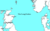
Long Forties
Encyclopedia
North Sea
In the southwest, beyond the Straits of Dover, the North Sea becomes the English Channel connecting to the Atlantic Ocean. In the east, it connects to the Baltic Sea via the Skagerrak and Kattegat, narrow straits that separate Denmark from Norway and Sweden respectively...
that is fairly consistently forty fathom
Fathom
A fathom is a unit of length in the imperial and the U.S. customary systems, used especially for measuring the depth of water.There are 2 yards in an imperial or U.S. fathom...
s (73 metres) deep (thus, on a nautical chart
Nautical chart
A nautical chart is a graphic representation of a maritime area and adjacent coastal regions. Depending on the scale of the chart, it may show depths of water and heights of land , natural features of the seabed, details of the coastline, navigational hazards, locations of natural and man-made aids...
with depth shown in fathoms, a long area with many "40" notations). It is located between the northeast coast of Scotland
Scotland
Scotland is a country that is part of the United Kingdom. Occupying the northern third of the island of Great Britain, it shares a border with England to the south and is bounded by the North Sea to the east, the Atlantic Ocean to the north and west, and the North Channel and Irish Sea to the...
and the southwest coast of Norway
Norway
Norway , officially the Kingdom of Norway, is a Nordic unitary constitutional monarchy whose territory comprises the western portion of the Scandinavian Peninsula, Jan Mayen, and the Arctic archipelago of Svalbard and Bouvet Island. Norway has a total area of and a population of about 4.9 million...
, centred about 57°N 0°30′E. Compare to the Broad Fourteens
Broad Fourteens
thumb|200px|right|The Broad Fourteens on a map by Delisle The Broad Fourteens is an area of the southern North Sea that is fairly consistently fourteen fathoms deep...
.
The Shipping Forecast
Shipping Forecast
The Shipping Forecast is a four-times-daily BBC Radio broadcast of weather reports and forecasts for the seas around the coasts of the British Isles. It is produced by the Met Office and broadcast by BBC Radio 4 on behalf of the Maritime and Coastguard Agency. The forecasts sent over the Navtex...
area "Forties" is named after it. The Dutch weather service KNMI uses for the same area the name of the Fladen Grounds, a slightly more northernly and deeper part of the North Sea. The Swedish weather service SMHI
SMHI
SMHI is an abbreviation for Sveriges Meteorologiska och Hydrologiska Institut, . SMHI is a government agency in Sweden and operates under the Ministry of Sustainable Development...
who reported weather for this area until 2005 also used the name Fladen for this area. The Norwegian forecast for the fisheries uses the term Fladen Grunn.