
Columbia Slough
Encyclopedia
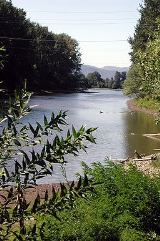
The Columbia Slough is a narrow waterway, about 19 miles (30.6 km) long, in the floodplain
of the Columbia River
in the U.S. state
of Oregon
. From its source in the Portland
suburb of Fairview
, the Columbia Slough meanders west through Gresham
and Portland to the Willamette River
, about 1 miles (1.6 km) from the Willamette's confluence with the Columbia. It is a remnant of the historic wetland
s between the mouths of the Sandy River
to the east and the Willamette River to the west. Levee
s surround much of the main slough
as well as many side sloughs, detached sloughs, and nearby lakes. Drainage district
employees control water flows
with pumps and floodgates. Tidal
fluctuations cause reverse flow on the lower slough.
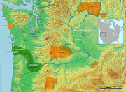
The Columbia floodplain
, formed by geologic processes including lava flows, volcanic eruptions, and the Missoula Floods
, is part of the Portland Basin, which extends across the Columbia River from Multnomah County, Oregon
, into Clark County, Washington
. Five percent of Oregon's population, about 158,000 people, live in the slough watershed
of about 51 square miles (132.1 km²). Municipal wells near the upper slough provide supplemental drinking water to Portland and nearby cities. The cities, the drainage districts, the county, and a regional government, Metro
, have overlapping jurisdictions in the watershed. A regional agency operates Portland International Airport
along the middle slough and marine terminals near the lower slough. The Oregon Department of Environmental Quality
(DEQ) and the city's Bureau of Environmental Services (BES) deal with environmental issues.
Long before non-indigenous people
explored the region, tribes of Native Americans
fished and hunted along the slough. In the early 19th century fur trappers and explorers including Lewis and Clark
visited the area before large migrations of settlers began arriving from the east. The newcomers farmed, cut timber, built houses, and by the early 20th century established cities, shipping ports, roads, rail lines and industries near the slough. Increased investment in the floodplain led to larger losses during floods, and these losses prompted levee building that greatly altered the area. A flood pouring through a levee break in 1948 destroyed the city of Vanport, which was never rebuilt.
Used as a waste repository during the first half of the 20th century and cut off from the Columbia River by levees, the slough became one of Oregon's most polluted waterways. Early attempts to mitigate the pollution, which included raw sewage and industrial waste, were unsuccessful. However, in 1952 Portland began sewage treatment, and over the next six decades the federal Clean Water Act
and similar legislation mandated further cleanup. State and local governments, often assisted by community volunteers, undertook projects related to public health, natural resources, and recreation in a region with many homes, industries, businesses, and roads. The businesses and industries in the watershed employ about 57,000 people, which is also frequented by more than 150 bird species and 26 fish species and animals including otters, beaver
, and coyote
s. One of the nation's largest freshwater urban wetlands, Smith and Bybee Wetlands Natural Area
, shares the lower slough watershed with a sewage treatment plant, marine terminals, a golf course, and a car racetrack. Watercraft able to portage over culvert
s and levees can travel the entire length of the slough. The 40 Mile Loop
and other hiking and biking trails follow the waterways and connect the parks.
, a swamp, a river inlet
or backwater, or a creek in a marsh
or tide flat
. The Columbia Slough is classified as a "stream" in the Geographic Names Information System
(GNIS) of the United States Geological Survey
(USGS). The slough takes its name from the Columbia River, of which it was historically a side channel or anabranch
. Robert Gray, a Boston fur trader and whaler who sailed partway up the Columbia River in 1792, named the river after his ship, Columbia Rediviva
. The Columbia part of the ship's name belonged to the tradition of naming things after explorer Christopher Columbus
.
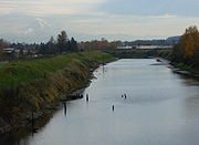
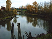
 The Columbia Slough flows roughly parallel to and about 0.4 to 1.7 mi (0.643736 to 2.7 km) south of the Columbia River in Multnomah County. It begins at Fairview Lake in the city of Fairview and immediately enters the city of Gresham. Less than 1 miles (1.6 km) later, it enters the city of Portland and continues generally westward for about another 18 miles (29 km) to its confluence with the Willamette River. Throughout its course, the slough is nearly level, 10 feet (3 m) above sea level
at the source and 9 feet (2.7 m) at the mouth. Semidiurnal tides cause reverse currents on the lower 8.5 miles (13.7 km) of the slough.
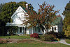
Running slightly north of and parallel to U.S. Route 30 (Sandy Boulevard), the slough flows by Zimmerman Heritage Farm
on the left bank (south) about 17.5 miles (28.2 km) from the mouth, Big Four Corners Wetlands on the right bank shortly thereafter, and receives Wilkes Creek on the left shortly after that. At about river mile
(RM) 15.5 or river kilometer (RK) 24.9, it passes through a gated levee that separates the upper slough from the middle slough. Soon it passes Prison Pond Wetlands near Inverness Jail and connects to Johnson Lake Slough, all on the left. Shortly thereafter, it flows under Interstate 205
. From here and for most of the rest of its course, the slough runs parallel to and slightly north of Columbia Boulevard. Passing Johnson Lake on the left, it crosses the Colwood National Golf Course and flows by Portland International Airport and an Oregon Air National Guard
base on the right. On the left is Whitaker Ponds Natural Area. Shortly thereafter, it receives Whitaker Slough on the left and crosses the Broadmoor Golf Course. Between 9 and 8 mi (14.5 and 12.9 km) from the mouth, it receives Buffalo Slough from the left and passes by the defunct Peninsula Drainage Canal (City Canal), which lies to the slough's right. At this point, it passes through a second gated levee that separates the middle slough from the lower slough and its tidal flow reversals.
In the next stretch, the Columbia Slough flows by Portland Meadows
horse racing track on the right and crosses under Interstate 5
at about RM 7 (RK 11). Beyond the interstate, to the slough's north lies Delta Park
, Portland International Raceway
, and the Heron Lakes Golf Course. Until flooding destroyed it in 1948, the city of Vanport occupied this site. To the south is the Columbia Boulevard Wastewater Treatment Plant.
The slough flows through the Wapato Wetland and by the Smith and Bybee Wetlands Natural Area, including the former St. Johns Landfill, on the right at about RM 3 (RK 4.8) from the Willamette River, and by Pier Park on the left. Shortly thereafter, it turns sharply north for the rest of its course. It receives North Slough, connected to Bybee Lake, on the right, and passes through the Ramsey Lake Wetlands and Kelley Point Park
before entering the Willamette River about 1 miles (1.6 km) from its confluence with the Columbia River. The mouth of the Columbia River is about 101 miles (162.5 km) further downstream at Astoria
on the Pacific Ocean.
0.6 mile (0.965604 km) from the mouth. The average flow recorded at this gauge is 103 cuft/s from a drainage area of undetermined size. The maximum flow was 2400 cuft/s on December 5, 1995, and the minimum flow (biggest reverse flow) was −6,700 cubic feet per second (−190 m3/s) on February 7, 1996, which coincided with a flood
on the Columbia and Willamette rivers.
of the Columbia River between the mouths
of the Sandy River
to the east and the Willamette River. Parts of Portland, Fairview, Gresham, Maywood Park
, Wood Village
, and unincorporated
Multnomah County lie within the drainage basin
(watershed). As of 2005, about 158,000 people, 5 percent of Oregon's population, lived in the basin.
The watershed includes residential neighborhoods, agriculture, the airport, open spaces, 54 schools, interstate highways, railways, commercial businesses, and heavy and light industry. In general, the northern part is industrial and commercial; the southern part is residential, and agricultural areas lie to the east. As of 2001, single-family residential zones
covered 33 percent of the watershed, and mixed-use zones accounted for another 33 percent. The other zones were 12 percent industrial, 12 percent parks or open space; 6 percent multi-family residential
, 3 percent commercial, and 2 percent were for farming or forests. As of 2005, about 3,900 businesses operated in the watershed and employed about 57,000 people.
Adjacent to the Columbia Slough basin are the watersheds of the Sandy River to the east, Johnson Creek
to the south, the Willamette to the south and west, and the Columbia to the north. Lying slightly north of the watershed, large islands in the Columbia River include, from east to west, McGuire Island, Government Island, Lemon Island, and Tomahawk Island, which is connected to Hayden Island
. Bordered by the Columbia and two arms of the Willamette, Sauvie Island
lies just west of the mouth of the slough.
, the regional governmental agency for the Oregon portion of the Portland metropolitan area
, is involved in acquiring and protecting wildlife habitat in places like Big Four Corners Wetlands and Smith and Bybee Wetlands Natural Area, acquiring property to close gaps in the 40 Mile Loop and other trails, and creating additional water access along the slough. The United States Environmental Protection Agency
(EPA) has designated the Oregon Department of Environmental Quality
(DEQ) to regulate the slough under provisions of the federal Clean Water Act
. The Port of Portland
, a regional agency run by commissioners appointed by the Oregon governor, owns and manages about 11 percent of the land in the slough watershed. Three drainage districts that manage water flows in the slough floodplain overlap parts of these other jurisdictions.
 The Columbia Slough is part of the roughly 770 mi2 Portland Basin, which lies at the northern end of the Willamette Valley
of Oregon and extends north into Clark County
in the state of Washington. The region is underlain by solidified lava
s of the Columbia River Basalt Group
that are up to 16 million years old. Covered by later alluvial
deposits, the basalts lie more than 1000 feet (304.8 m) below the surface within the basin. About 10 million years ago, eruptions of Cascade Range volcanoes to the east sent flows of mud, ash, and eroded volcanic debris into the Columbia, which was powerful enough to carry the material downstream. Deposited above the basalt during the Miocene
and early Pliocene
, these loose sands and gravels formed part of what is known as the Troutdale Formation. Extending to the Tualatin River
Valley to the south and into Clark County on the north, the formation is an aquifer
that is the primary source of drinking water for Vancouver
in Washington and an auxiliary source for Portland.
The Portland Basin is being pulled slowly apart between faults in the Tualatin Mountains
(West Hills) on the west side of Portland, the East Bank fault along the east side of the Willamette River, and other fault systems near Gresham
further east. About 3 million years ago, many small volcanoes and cinder cones erupted through the thin, stretched crust of the basin and in the Cascade foothills to the southeast. Ash, cinders, and debris from these Boring Lava Field
volcanoes added another layer of sediment to the Troutdale formation.
About 15,000 years ago, cataclysmic ice age
events known as the Missoula Floods
or Bretz Floods originating in the Clark Fork
region of northern Idaho
inundated the Columbia River basin many times. These floods deposited huge amounts of debris and sediment. Water filled the entire Columbia Gorge to overflowing and turned the Willamette Valley into a lake 100 miles (160.9 km) long, 60 miles (96.6 km) wide and 300 feet (91.4 m) deep. The floodwaters ripped the face off Rocky Butte
in Portland and deposited a 5 miles (8 km) gravel bar, Alameda Ridge
, that runs parallel to and slightly south of the Columbia Slough.
Faults associated with the expanding Portland Basin are capable of producing significant earthquakes. More than a thousand earthquakes, many too small to be felt, have been recorded in the basin since 1841. The stronger ones reached about magnitude 5 on the Richter scale
. In 1892, one estimated at magnitude 5 shook downtown Portland for about 30 seconds. In 1962, one centered about 7 miles (11.3 km) north of Portland was estimated at between magnitude 4.9 and 5.2.
Historically, most rain falling on the watershed was taken up by vegetation, flowed into wetlands, soaked into the ground, or evaporated. Heavy rain in the winter months recharged the groundwater
and provided baseflow
s to the slough during dry summers. Urban development, which replaced vegetation and water-absorbing soils with airport runways, house roofs, highways, warehouses, parking lots, and other hard surfaces, interrupted this cycle. In 1999, a study estimated that impervious surfaces covered 54 percent of the watershed. Storm runoff
that might have taken days to reach the historic slough reaches the developed slough in hours.
 The upper slough extends from the slough's source at Fairview Lake, roughly 18.5 miles (30 km) from the mouth, to a gated levee known as the mid-dike levee about 3 miles (5 km) downstream. This sector, managed by MCDD, covers 2650 acres (1,072.4 ha) completely surrounded by levees. A northern side channel extends from the mid-dike levee to MCDD Pump Station No. 4 on the Columbia River (Marine Drive) levee near Big Four Corners. Water usually exits this sector through the open gates of the mid-dike levee, but to control threatening flows the MCDD can close the gate and pump water from the northern side channel directly into the Columbia. The pump's maximum capacity is 275000 U.S.gal/min.
The middle slough, also managed by MCDD, lies between the mid-dike levee and the Pen 2 levee, 8.5 miles (13.7 km) from the mouth. This sector covers 6848 acres (2,771.3 ha), is completely surrounded by levees, and contains many side sloughs, ponds, small lakes, and springs. Pump Station No. 1 rests on the Pen 2 levee, which is gated across the course of the slough. To control flows, MCDD can open or close the gates, and it can pump water from the middle slough to the lower slough when its flow is reversed by the tide or when gravity flow is insufficient. The pump's capacity is 250000 USgal/min.
Water levels in the lower slough, managed by Pen 2 and Pen 1, depend more on Willamette River conditions than on pumping by MCDD. Incoming tides cause a variation in water surface elevation of between 12 inches (30.5 cm) and 24 inches (61 cm) roughly twice per day along the entire lower slough. Flow direction varies with the tide. Pen 2 and Pen 1, separated by Interstate 5, border the north side of the lower slough. Pen 2 manages 1475 acres (596.9 ha) east of the highway, and Pen 1 manages 901 acres (364.6 ha) to the west (downstream). Multiple pump stations move water from lesser sloughs in both districts into the main slough. Parts of this subwatershed are unprotected by levees and are vulnerable to 100-year flood
s.
 Historically Fairview Creek flowed north into the Columbia River through a wetlands slightly upstream of Big Four Corners. In the early 20th century, water managers dug an artificial channel connecting the Fairview Creek wetlands to the slough. In 1960, they built a dam on the west side of the wetlands to create Fairview Lake for water storage and recreation. It covers about 100 acres (40.5 ha) and is 5 to 6 ft (1.5 to 1.8 m) deep. Fairview Creek forms in a wetland near Grant Butte and flows north for 5 miles (8 km) through the cities of Gresham and Fairview to reach the lake. Fairview Creek has two named tributaries, No Name Creek, and Clear Creek. A smaller stream, Osborn Creek, also flows into the lake, which empties through a weir
and culvert
system into the upper slough.
With one exception, the streams feeding Fairview Lake are the watershed's only remaining creeks, although springs
also reach the surface. Wilkes Creek, the slough's only free flowing tributary, is about 2 miles (3 km) long and enters the upper slough from the south. Dozens of similar streams that once flowed into the slough from the south have all been piped or filled.
Many bodies of water in addition to the main slough channel lie within the drainage basin. The area around the middle slough contains several slough arms and small lakes, including Buffalo Slough, Whitaker Slough, Johnson Lake, Whitaker Ponds, and Prison Pond. In the lower slough, Smith and Bybee Wetlands Natural Area
at 2000 acres (809.4 ha) is one of the largest urban freshwater wetlands in the United States. A 1 miles (1.6 km) side slough called North Slough connects Bybee Lake and the main slough channel. A water control structure at the outlet from Bybee Lake to the North Slough regulates the lakes' levels.
near the surface supply an estimated flow between 50 cuft/s to the middle and upper sloughs. Rain infiltration and artificial sump
s recharge this shallow aquifer. Geologists have identified four other major aquifers separated by relatively impermeable clays or other strata
at various levels below the surface aquifer. The City of Portland's water bureau manages the Columbia South Shore Well Field that taps the deeper aquifers. As of 2004, 25 active wells drawing from depths ranging from 60 to 600 ft (18.3 to 182.9 m) could produce up to 100 million USgals (378,541.2 m³) a day from the field. These were drilled between 1976 and 2003 to supplement the city's main water supply from the Bull Run Watershed during droughts or emergencies. The Rockwood Water People's Utility District (PUD) and the City of Fairview have also drilled three wells near the upper slough.
 Archeological evidence suggests that Native Americans
lived along the lower Columbia River as early as 10,000 years ago, including near what later became The Dalles
, on the Columbia River about 70 miles (112.7 km) east of the Columbia Slough. By 2,000 to 3,000 years ago, the Clackamas Indians had settled along the Clackamas River
, which empties into the Willamette River about 25 miles (40.2 km) south of the slough. The Clackamas tribe was a subgroup of the Chinookan
speakers who lived in the Columbia River Valley from Celilo Falls
to the Pacific Ocean. Clackamas lands included the lower Willamette River from Willamette Falls
, at what later became Oregon City
, to the Willamette's confluence with the Columbia River. The Columbia River floodplain
near the mouth of the Willamette contained many stream channels, lakes, and wetlands that flooded annually. Chinookan tribes hunted and fished there and traveled between the two big rivers via the protected waters of the slough. Their main food sources were salmon, sturgeon
, and camas.
In 1792, Lieutenant William Broughton
, a British explorer, led the first trip by non-natives as far up the Columbia River as the mouth of the Sandy River
. He and his men camped on Sauvie Island
, which lies between the Willamette and Columbia rivers directly opposite the mouth of the slough. Broughton encountered many Chinookans while exploring and mapping geographic features including Hayden Island
and other islands in the Columbia just north of the slough. When Lewis and Clark
visited the area in 1806, the Clackamas tribe consisted of about 1,800 people living in 11 villages. The explorers estimated that 800 people of the Multnomah tribe
of Chinookans lived in five villages on Sauvie Island.
In 1825, the Hudson's Bay Company
established its western administrative headquarters at Fort Vancouver
, across the Columbia River from the slough. The British fort became the center for fur trading and other commerce throughout the Pacific Northwest, including what would later become the state of Oregon. By the 1830s, smallpox
, malaria
, measles
and other diseases carried by non-indigenous explorers and traders had reduced the native population by up to 90 percent throughout the lower Columbia basin. The United States gained control over the Oregon Territory
—including Fort Vancouver, the Portland Basin, and the slough—by treaty with Great Britain in 1846. By 1851, the Clackamas tribe's population had fallen to 88, and in 1855 the tribe signed a treaty surrendering its lands to the U.S.
 By 1850, White
settlers established donation land claims
in the Columbia Slough watershed. One settler, Lewis Love, became wealthy by cutting timber in the watershed and using the slough as part of a shipping route to downtown Portland. Other settlers logged the forests near the slough and built sawmills, fished, and farmed. In 1852, James John operated a ferry based on the peninsula of land between the Columbia and the Willamette River. The community of St. Johns
, plat
ted in the same year on the peninsula, is named after him. Legislation creating the Port of Portland
in 1891 improved St. Johns' prospects as a Willamette River port. In 1902, the U.S. Congress passed a Reclamation Act
that encouraged irrigation, flood control, and wetland development in places like the peninsula. In 1907, the Spokane, Portland and Seattle Railway
began work on a rail line across the peninsula. The railway and the port improvements led to high expectations. "St. Johns, the City of Destiny", a 1909 editorial appearing in a booster
publication called The Peninsula, said:
bought 3400 acres (1,375.9 ha) in 1906 and established the community of Kenton
. Other companies built packing plants and slaughterhouse
s along the slough, and by 1911 Portland had become the main livestock market for the Pacific Northwest
. These and other early 20th century businesses, including stockyards, a dairy farm, a shingle company, and a lumber mill, flushed waste products into the slough. Starting in 1910, north Portland's residential sewage also poured into the slough through pipes laid for the purpose.
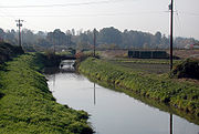
In 1917, landowners along the slough had formed three drainage districts to control floods. They dug ditches, deepened existing water channels, and built levees to keep the rivers and the slough from flooding agricultural, industrial, and commercial property. Hoping to flush the slough with clean water from the river, city engineers created the crosscutting Peninsula Canal. The project largely failed because daily tides reversed the slough's flow and because both ends of the canal were at nearly the same elevation.
Over the next 30 years, more lumber and wood products companies opened along the slough, and tugboats moved log rafts up and down the waterway. Truck freight and other transportation companies built in the watershed. The city created the St. Johns Landfill on wetlands and small channels off the lower slough and built a new Portland Airport
on land along the middle slough. Activists and civic leaders, concerned about pollution on the Willamette River, led cleanup campaigns, but voters declined to pay for sewage treatment. Pollution eventually grew so bad on the slough that mill workers refused to handle logs that had been stored in its water.
signed an order for internment
of all the people of Japanese ancestry who lived on the West Coast
. About 1,700 of them lived in Portland, and some had farms or businesses near the slough. When the government removed them from their homes in 1942, it housed them temporarily in the Livestock Exposition Center
(Expo Center) in Kenton before sending them to internment camps further inland. They were not allowed to return until 1945.
 In 1942, Kaiser Shipbuilding Company
began making ships for the war at three huge installations near the lower slough, one in St. Johns, one on Swan Island in Portland's Overlook
neighborhood, and one in Vancouver, Washington. St. Johns and Vancouver made Liberty ship
s, while Swan Island made tankers
. The St. Johns shipyard became the nation's leading producer of Liberty ships. To house shipyard workers and their families, Henry J. Kaiser
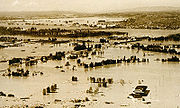
bought 650 acres (263 ha) of former marsh, pasture, and farmland in the lower slough watershed surrounded on all sides by dikes between 15 and 25 ft (4.6 and 7.6 m) high. Here he built a new city, at first called Kaiserville and later Vanport. By 1943, Vanport's population of 39,000 made it the second largest city in Oregon and the largest wartime housing project in the U.S. After the war, the population fell to about 18,500. This was roughly the number of people living there on May 30, 1948, when a flood broke through Vanport's western levee. The break occurred during the afternoon of a day with mild weather. The first rush of water soon became a "creeping inundation", slowed in its advance for 35 to 40 minutes by water-absorbing sloughs. The water's gradual rise within the city allowed most of the residents to escape drowning. The county coroner
's official list of bodies recovered was set at fifteen, and seven people on a list of missing people were never found. The flood destroyed the city, which was never rebuilt.
The Vanport flood induced changes to the slough's system of levees, which were rebuilt and in some cases fortified to withstand a 100-year flood
. Instead of repairing the levee along the Peninsula Canal, the city plugged it at both ends. The disaster also affected Oregon's system of higher education. After floodwaters destroyed the Vanport Extension Center, set up in 1946, the Oregon Board of Higher Education reestablished the school in downtown Portland, where it eventually became Portland State University
.
 Debate about how to use the slough and its watershed continued through the rest of the century. In 1964, the Port of Portland, interested in industrial development, began to fill Smith, Bybee, and Ramsey lakes with dredge sands from the Columbia. In the 1970s, the Oregon Legislature passed a law against filling Smith or Bybee lakes below a contour line
11 feet (3.4 m) above mean sea level except to enhance fish and wildlife habitat. Plans for a Willamette River Greenway project proposed by Oregon Governor Tom McCall
in the late 1960s called for park and recreation areas along the Willamette and many of its tributaries but ignored the slough. Some planners argued that the slough was so filthy that more industry was all it was good for. They portrayed cleanup as a lofty but impractical goal.
At Oregon's request, the U.S. Congress
stripped the slough of its navigable status in 1978. This ended channel dredging on the slough, which could then be used for recreation. Other laws affecting the slough in the 1970s and beyond were the federal Clean Water Act
and the Oregon Comprehensive Land Use Planning Act. In 1986, a business association began promoting commercial development along the upper slough, and the city later used urban renewal
funds to support industrial projects near the airport. In 1996 the city acquired the Whitaker Ponds Natural Area, where it began a slough watershed education program for children.
 After years of piping raw sewage directly into the waterway, Portland built its first sewage treatment plant next to the lower slough in 1952. The Columbia Boulevard Wastewater Treatment Plant handled a combination of raw sewage and storm runoff that flowed into the sanitary sewer system from all over the city and piped the treated water into the Columbia River. When runoff exceeded the plant's capacity during heavy rains, sewage still entered the slough from combined sewer overflows (CSO)s at 13 outfalls.
The city closed the St. Johns Landfill, adjacent to the lower slough, in 1991. Pressed by citizen action groups, it agreed in 1993 to establish a 50 feet (15.2 m) environmental conservation zone along the slough. In response to a threatened lawsuit, the city began a comprehensive cleanup of the slough in 1994, and a year later it received a $10 million grant from the EPA for the purpose.
Of the streams monitored in the lower Willamette basin by the Oregon Department of Environmental Quality
(DEQ) between 1986 and 1995, the Columbia Slough had the worst pollution scores. DEQ's measurements came from the slough at Landfill Road, 2.6 miles (4.2 km) from the mouth. On the Oregon Water Quality Index (OWQI) used by DEQ, water quality scores can vary from 10 (worst) to 100 (ideal). The average for the Columbia Slough was 22, or "very poor". By comparison, the average in the Willamette River at the Hawthorne Bridge
in downtown Portland was 74 during the same years. Measurements of water quality at the Landfill Road site during the years covered by the DEQ report showed high concentrations of phosphate
s, ammonia
and nitrate
s, fecal coliform bacteria
, and suspended solids, and a high biochemical oxygen demand
. High temperatures enhanced extreme eutrophication
in the summer.
The Port of Portland began efforts in 1997 to reduce the flow of aircraft deicing chemicals from the airport into the waterway, though it still diverts concentrated chemicals (mostly glycol) directly into the slough during rare times of reservoir overflow.
By 2000 the City of Portland had spent about $200 million to nearly eliminate CSOs from entering the slough. It also replaced septic tank
and cesspool
systems near the middle and upper slough with sanitary sewer
s. BES analysis of water samples taken between 1995 and 2002 showed that by the end of this period DEQ water quality standards for Escherichia coli
, the indicator organism for fecal contamination, were nearly always being met in the upper and middle sloughs and generally being met in the lower slough. Despite these and other improvements in water quality, the slough is not a safe source of edible fish. The Multnomah County Health Department and other agencies have advised people to avoid or greatly reduce consumption of fish and crayfish
from the slough because they contain polychlorinated biphenyl
s (PCB) and pesticide
s.
survey, compared the watershed of 1851 with that of 2003. The study showed that all of the watershed provided plant and wildlife habitat
in 1851, but by 2003 only 33 percent provided habitat. In 1851, water covered 10 percent of the watershed but that had been cut in half by 2003. Marshes and other wetland
s that had comprised 22 percent of the earlier watershed dwindled to 1 percent by 2003, while the percentage of land devoted to industry, commerce, and homes rose from 0 to 34. In addition, habitat remaining in 2003 was greatly disturbed, dominated by Himalayan blackberry
and other invasive species
and fragmented by roads. The riparian zone
along the slough was generally narrow or nonexistent and devoid of trees and shrubs in places, including along the levees.
In 2002 the city, the MCDD, and the U.S. Army Corps of Engineers
began a project to improve habitat by creating 7 miles (11.3 km) of stream meander
s and wetland terraces along the slough. Through its Watershed Revegetation Program, begun in 1996, the city worked with property owners to plant native vegetation and to remove invasive weeds. Through 2005, participants had replanted more than 500 acres (202.3 ha) along nearly 40 miles (64.4 km) of riparian corridors in the slough watershed. Other strategies pursued by the city, Metro, and other interest groups include connecting separated habitats with a continuous riparian corridor, removing wildlife corridor barriers, restoring hydrological connections to the slough, and restoring the floodplain where feasible.
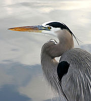 Although reduced and altered, habitats in the watershed support a wide range of wildlife, some of which is found nowhere else in Portland. Many species that used the slough in 1850 still use it. This includes more than 150 species of birds, 26 species of fish of which 12 species are native several kinds of amphibian
s, western pond turtle
s, beaver
, muskrat
, river otter, and black-tailed deer
. Juvenile salmon
enter the lower slough as well as Smith and Bybee Lakes. Cutthroat trout
inhabit Fairview Creek and Osborn Creek. Three species of native freshwater mussel live in the slough and in Smith and Bybee Lakes. Crayfish have been found throughout the slough. Bald Eagle
s are among the resident birds, and Great Blue Heron
s have established rookeries
in the watershed. Migrants that visit the slough include more than a dozen species of ducks, geese, swans, and raptors
, as well as neotropical shorebirds and songbirds. Invasive species
adapted to the slough include the nutria, common carp
, bullfrog
, and European Starling
.
designated by the U.S. Environmental Protection Agency
(EPA). Black cottonwood
, red osier dogwood
, willow
, Oregon white oak, and Oregon ash grow in scattered locations throughout the watershed, while wapato
and Columbia sedge
thrive in a few places. In the slough itself, macrophyte
s and algae
sometimes restrict water flow and reduce water quality. Golf courses and athletic fields near the slough consist mainly of non-native grasses. Developed plots with houses or businesses often have deciduous
street trees, grasses, occasional conifers
, and a variety of native and non-native shrub
s. Invasive plants include Himalayan blackberry, English ivy, reed canarygrass, purple loosestrife
, and Japanese knotweed
.
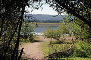
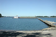
, a 101 acres (40.9 ha) recreational park with a 64 acres (25.9 ha) lake, both managed by Metro
. To the northeast on the Columbia River is Chinook Landing Marine Park, also managed by Metro. At about 67 acres (27.1 ha), it is Oregon's largest public boating park.
 Big Four Corners Wetlands, managed by the Portland Parks & Recreation
Department (PPR), includes about 165 acres (66.8 ha) of wetlands and forests about 17 miles (27.4 km) from the slough's confluence with the Willamette River. Providing habitat for deer, coyote
s, and river otter as well as birds and amphibians, it is the fourth largest natural area in the city. Further downstream, a consortium of interest groups is restoring a natural area of about 9 acres (3.6 ha) at Johnson Lake. Whitaker Ponds Natural Area, at about RM 10 (RK 16), is a 14 acres (5.7 ha) site with an environmental school. West of Whitaker Ponds, the Columbia Children's Arboretum, with every state tree, lies on a 29 acres (11.7 ha) property managed by PPR.
Delta Park
is a large municipal park complex that straddles Interstate 5 between the slough and the Columbia River at the former Vanport site. East Delta Park, covering about 85 acres (34.4 ha), has a sports complex and a street-tree arboretum. Portland International Raceway
, for car, motorcycle, and bicycle racing, occupies about 292 acres (118.2 ha) of West Delta Park. Adjacent to the raceway is the Heron Lakes Golf Course, 340 acres (137.6 ha). The grounds include wetlands and interpretive signs about Vanport. Smith and Bybee Wetlands Natural Area
, a public park and nature reserve managed by Metro, lies just west of Delta Park. At about 2000 acres (809.4 ha), it is one of the largest urban freshwater wetlands in the United States. Kelley Point Park
covers 104 acres (42.1 ha) at the tip of the peninsula between the Willamette and Columbia rivers.
skirt the north edge of the slough watershed, while other segments such as the north–south I-205 Bike Path
cross it or, as in the case of the largely unfinished Columbia Slough Trail, run through it generally along an east–west axis. The 40 Mile Loop is a partly completed greenway
trail around and through Portland and other parts of Multnomah County. Originally proposed by the Olmsted Brothers
, architects involved in the planning for Portland's Lewis and Clark Centennial Exposition
of 1905, it has expanded to a projected 140 miles (225.3 km), encircling the city and connecting parks along the Columbia, Sandy, and Willamette rivers and Johnson Creek
. The parks and other public spaces in the watershed have their own pedestrian paths, some of which are also bicycle paths that connect to the 40 Mile Loop. Many gaps lie between completed trail segments.
Along the east side of the slough watershed, the City of Gresham has opened a 1.24 miles (2 km) segment of the Gresham-Fairview Trail, a planned 5.2 miles (8.4 km), north–south hiking and biking route between the Springwater Corridor
along Johnson Creek and the 40 Mile Loop along the Columbia River. On the west side of the watershed, the Peninsula Crossing Trail connects Willamette Cove on the Willamette River in St. Johns with the 40 Mile Loop along the Columbia River. This 3 miles (4.8 km) linear hiking and biking trail crosses the lower slough and passes between Smith Lake and Heron Lakes Golf Course. The trail is level and accessible by wheelchair
. Amenities include a picnic area, seats carved from basalt
, and art installations.
s around levees and other obstacles. BES estimates the time required for a canoe trip of roughly 18 miles (29 km) along the main channel to be at least nine hours. Trips along the lower 8.5 miles (13.7 km) must be timed with the tides to allow paddling with the current. Eight launch sites, including one just below Fairview Lake at the headwaters and another at Kelley Point Park near the mouth, have been established along the slough.
Floodplain
A floodplain, or flood plain, is a flat or nearly flat land adjacent a stream or river that stretches from the banks of its channel to the base of the enclosing valley walls and experiences flooding during periods of high discharge...
of the Columbia River
Columbia River
The Columbia River is the largest river in the Pacific Northwest region of North America. The river rises in the Rocky Mountains of British Columbia, Canada, flows northwest and then south into the U.S. state of Washington, then turns west to form most of the border between Washington and the state...
in the U.S. state
U.S. state
A U.S. state is any one of the 50 federated states of the United States of America that share sovereignty with the federal government. Because of this shared sovereignty, an American is a citizen both of the federal entity and of his or her state of domicile. Four states use the official title of...
of Oregon
Oregon
Oregon is a state in the Pacific Northwest region of the United States. It is located on the Pacific coast, with Washington to the north, California to the south, Nevada on the southeast and Idaho to the east. The Columbia and Snake rivers delineate much of Oregon's northern and eastern...
. From its source in the Portland
Portland, Oregon
Portland is a city located in the Pacific Northwest, near the confluence of the Willamette and Columbia rivers in the U.S. state of Oregon. As of the 2010 Census, it had a population of 583,776, making it the 29th most populous city in the United States...
suburb of Fairview
Fairview, Oregon
As of the census of 2000, there were 7,561 people, 2,831 households, and 1,936 families residing in the city. The population density was 2,360.8 people per square mile . There were 3,116 housing units at an average density of 972.9 per square mile...
, the Columbia Slough meanders west through Gresham
Gresham, Oregon
- Demographics :As of the census of 2000, there were 90,205 people, 33,327 households, and 22,695 families residing in the city. The population density was 4,071.6 people per square mile . There were 35,309 housing units at an average density of 1,593.8 per square mile...
and Portland to the Willamette River
Willamette River
The Willamette River is a major tributary of the Columbia River, accounting for 12 to 15 percent of the Columbia's flow. The Willamette's main stem is long, lying entirely in northwestern Oregon in the United States...
, about 1 miles (1.6 km) from the Willamette's confluence with the Columbia. It is a remnant of the historic wetland
Wetland
A wetland is an area of land whose soil is saturated with water either permanently or seasonally. Wetlands are categorised by their characteristic vegetation, which is adapted to these unique soil conditions....
s between the mouths of the Sandy River
Sandy River (Oregon)
The Sandy River is a tributary of the Columbia River in northwestern Oregon in the United States. Measured by a United States Geological Survey gauge downstream of the Sandy's confluence with the Bull Run River, from the mouth, the river's average discharge is . The maximum daily recorded flow...
to the east and the Willamette River to the west. Levee
Levee
A levee, levée, dike , embankment, floodbank or stopbank is an elongated naturally occurring ridge or artificially constructed fill or wall, which regulates water levels...
s surround much of the main slough
Slough (hydrology)
For other uses, see Slough .Slough , is a term in hydrology that refers to:* Slough, a stream distributary or anabranch, or in some cases, a regular stream.More localized meanings of Slough are:...
as well as many side sloughs, detached sloughs, and nearby lakes. Drainage district
Drainage district
Drainage districts occur in England and Wales, varying in size from a few hundred acres to over , all in low lying areas of the country where flood risk management and land drainage are sensitive issues...
employees control water flows
Fluid dynamics
In physics, fluid dynamics is a sub-discipline of fluid mechanics that deals with fluid flow—the natural science of fluids in motion. It has several subdisciplines itself, including aerodynamics and hydrodynamics...
with pumps and floodgates. Tidal
Tide
Tides are the rise and fall of sea levels caused by the combined effects of the gravitational forces exerted by the moon and the sun and the rotation of the Earth....
fluctuations cause reverse flow on the lower slough.
The Columbia floodplain
Floodplain
A floodplain, or flood plain, is a flat or nearly flat land adjacent a stream or river that stretches from the banks of its channel to the base of the enclosing valley walls and experiences flooding during periods of high discharge...
, formed by geologic processes including lava flows, volcanic eruptions, and the Missoula Floods
Missoula Floods
The Missoula Floods refer to the cataclysmic floods that swept periodically across eastern Washington and down the Columbia River Gorge at the end of the last ice age. The glacial flood events have been researched since the 1920s...
, is part of the Portland Basin, which extends across the Columbia River from Multnomah County, Oregon
Multnomah County, Oregon
Multnomah County is one of 36 counties in the U.S. state of Oregon. Though smallest in area, it is the most populous as its county seat, Portland, is the state's largest city...
, into Clark County, Washington
Clark County, Washington
Clark County is a county located in the southwestern part of the U.S. state of Washington, across the Columbia River from Portland, Oregon.Clark County was the first county of Washington, named after William Clark of the Lewis and Clark Expedition...
. Five percent of Oregon's population, about 158,000 people, live in the slough watershed
Drainage basin
A drainage basin is an extent or an area of land where surface water from rain and melting snow or ice converges to a single point, usually the exit of the basin, where the waters join another waterbody, such as a river, lake, reservoir, estuary, wetland, sea, or ocean...
of about 51 square miles (132.1 km²). Municipal wells near the upper slough provide supplemental drinking water to Portland and nearby cities. The cities, the drainage districts, the county, and a regional government, Metro
Metro (Oregon regional government)
Metro, formerly known as Metropolitan Service District, is the regional governmental agency for the Oregon portion of the Portland metropolitan area...
, have overlapping jurisdictions in the watershed. A regional agency operates Portland International Airport
Portland International Airport
Portland International Airport is a joint civil-military airport and the largest airport in the U.S. state of Oregon, accounting for 90% of passenger travel and more than 95% of air cargo of the state. It is located within Portland's city limits just south of the Columbia River in Multnomah...
along the middle slough and marine terminals near the lower slough. The Oregon Department of Environmental Quality
Oregon Department of Environmental Quality
The Oregon Department of Environmental Quality is the chief regulatory agency of the government of the U.S. state of Oregon responsible for protecting and enhancing the state's natural resources and managing sanitary and toxic waste disposal. The agency employs approximately 700 scientists,...
(DEQ) and the city's Bureau of Environmental Services (BES) deal with environmental issues.
Long before non-indigenous people
Indigenous peoples
Indigenous peoples are ethnic groups that are defined as indigenous according to one of the various definitions of the term, there is no universally accepted definition but most of which carry connotations of being the "original inhabitants" of a territory....
explored the region, tribes of Native Americans
Native Americans in the United States
Native Americans in the United States are the indigenous peoples in North America within the boundaries of the present-day continental United States, parts of Alaska, and the island state of Hawaii. They are composed of numerous, distinct tribes, states, and ethnic groups, many of which survive as...
fished and hunted along the slough. In the early 19th century fur trappers and explorers including Lewis and Clark
Lewis and Clark Expedition
The Lewis and Clark Expedition, or ″Corps of Discovery Expedition" was the first transcontinental expedition to the Pacific Coast by the United States. Commissioned by President Thomas Jefferson and led by two Virginia-born veterans of Indian wars in the Ohio Valley, Meriwether Lewis and William...
visited the area before large migrations of settlers began arriving from the east. The newcomers farmed, cut timber, built houses, and by the early 20th century established cities, shipping ports, roads, rail lines and industries near the slough. Increased investment in the floodplain led to larger losses during floods, and these losses prompted levee building that greatly altered the area. A flood pouring through a levee break in 1948 destroyed the city of Vanport, which was never rebuilt.
Used as a waste repository during the first half of the 20th century and cut off from the Columbia River by levees, the slough became one of Oregon's most polluted waterways. Early attempts to mitigate the pollution, which included raw sewage and industrial waste, were unsuccessful. However, in 1952 Portland began sewage treatment, and over the next six decades the federal Clean Water Act
Clean Water Act
The Clean Water Act is the primary federal law in the United States governing water pollution. Commonly abbreviated as the CWA, the act established the goals of eliminating releases of high amounts of toxic substances into water, eliminating additional water pollution by 1985, and ensuring that...
and similar legislation mandated further cleanup. State and local governments, often assisted by community volunteers, undertook projects related to public health, natural resources, and recreation in a region with many homes, industries, businesses, and roads. The businesses and industries in the watershed employ about 57,000 people, which is also frequented by more than 150 bird species and 26 fish species and animals including otters, beaver
Beaver
The beaver is a primarily nocturnal, large, semi-aquatic rodent. Castor includes two extant species, North American Beaver and Eurasian Beaver . Beavers are known for building dams, canals, and lodges . They are the second-largest rodent in the world...
, and coyote
Coyote
The coyote , also known as the American jackal or the prairie wolf, is a species of canine found throughout North and Central America, ranging from Panama in the south, north through Mexico, the United States and Canada...
s. One of the nation's largest freshwater urban wetlands, Smith and Bybee Wetlands Natural Area
Smith and Bybee Wetlands Natural Area
Smith and Bybee Wetlands Natural Area is a public park and nature reserve between the Columbia Slough and the Columbia River in Portland, Oregon. At about , it is one of the largest urban freshwater wetlands in the United States. Metro, the regional government for the Oregon part of the Portland...
, shares the lower slough watershed with a sewage treatment plant, marine terminals, a golf course, and a car racetrack. Watercraft able to portage over culvert
Culvert
A culvert is a device used to channel water. It may be used to allow water to pass underneath a road, railway, or embankment. Culverts can be made of many different materials; steel, polyvinyl chloride and concrete are the most common...
s and levees can travel the entire length of the slough. The 40 Mile Loop
40 Mile Loop
The 40-Mile Loop is a partially completed greenway trail around and through Portland in the U.S. State of Oregon. It was proposed in 1903 by the Olmsted Brothers architecture firm as part of the development of Forest Park....
and other hiking and biking trails follow the waterways and connect the parks.
Name
Slough usually rhymes with shoe in the U.S. except in New England, where it usually rhymes with now, the preferred British pronunciation. Slough may mean a place of deep mud or mireBog
A bog, quagmire or mire is a wetland that accumulates acidic peat, a deposit of dead plant material—often mosses or, in Arctic climates, lichens....
, a swamp, a river inlet
Inlet
An inlet is a narrow body of water between islands or leading inland from a larger body of water, often leading to an enclosed body of water, such as a sound, bay, lagoon or marsh. In sea coasts an inlet usually refers to the actual connection between a bay and the ocean and is often called an...
or backwater, or a creek in a marsh
Marsh
In geography, a marsh, or morass, is a type of wetland that is subject to frequent or continuous flood. Typically the water is shallow and features grasses, rushes, reeds, typhas, sedges, other herbaceous plants, and moss....
or tide flat
Mudflat
Mudflats or mud flats, also known as tidal flats, are coastal wetlands that form when mud is deposited by tides or rivers. They are found in sheltered areas such as bays, bayous, lagoons, and estuaries. Mudflats may be viewed geologically as exposed layers of bay mud, resulting from deposition of...
. The Columbia Slough is classified as a "stream" in the Geographic Names Information System
Geographic Names Information System
The Geographic Names Information System is a database that contains name and locative information about more than two million physical and cultural features located throughout the United States of America and its territories. It is a type of gazetteer...
(GNIS) of the United States Geological Survey
United States Geological Survey
The United States Geological Survey is a scientific agency of the United States government. The scientists of the USGS study the landscape of the United States, its natural resources, and the natural hazards that threaten it. The organization has four major science disciplines, concerning biology,...
(USGS). The slough takes its name from the Columbia River, of which it was historically a side channel or anabranch
Anabranch
An anabranch is a section of a river or stream that diverts from the main channel or stem of the watercourse and rejoins the main stem downstream. Local anabranches can be the result of small islands in the watercourse...
. Robert Gray, a Boston fur trader and whaler who sailed partway up the Columbia River in 1792, named the river after his ship, Columbia Rediviva
Columbia Rediviva
Columbia Rediviva was a privately owned ship under the command of John Kendrick, along with Captain Robert Gray, best known for going to the Pacific Northwest for the maritime fur trade. The "Rediviva" was added to her name upon a rebuilding in 1787...
. The Columbia part of the ship's name belonged to the tradition of naming things after explorer Christopher Columbus
Christopher Columbus
Christopher Columbus was an explorer, colonizer, and navigator, born in the Republic of Genoa, in northwestern Italy. Under the auspices of the Catholic Monarchs of Spain, he completed four voyages across the Atlantic Ocean that led to general European awareness of the American continents in the...
.
Course
Sea level
Mean sea level is a measure of the average height of the ocean's surface ; used as a standard in reckoning land elevation...
at the source and 9 feet (2.7 m) at the mouth. Semidiurnal tides cause reverse currents on the lower 8.5 miles (13.7 km) of the slough.
Running slightly north of and parallel to U.S. Route 30 (Sandy Boulevard), the slough flows by Zimmerman Heritage Farm
Jacob Zimmerman House
Jacob Zimmerman House was the home of Jacob and Lena Zimmerman, European American settlers who came west over the Oregon Trail in 1851 to what became Multnomah County in the U.S. state of Oregon. Built in 1874, the house was part of a dairy farm. Members of the Zimmerman family lived on the farm...
on the left bank (south) about 17.5 miles (28.2 km) from the mouth, Big Four Corners Wetlands on the right bank shortly thereafter, and receives Wilkes Creek on the left shortly after that. At about river mile
River mile
In the United States, a River mile is a measure of distance in miles along a river from its mouth. River mile numbers begin at zero and increase further upstream. The corresponding metric unit using kilometers is the River kilometer...
(RM) 15.5 or river kilometer (RK) 24.9, it passes through a gated levee that separates the upper slough from the middle slough. Soon it passes Prison Pond Wetlands near Inverness Jail and connects to Johnson Lake Slough, all on the left. Shortly thereafter, it flows under Interstate 205
Interstate 205 (Oregon-Washington)
Interstate 205 is a loop route that serves the Portland—Vancouver metropolitan area in the U.S. states of Oregon and Washington. I-205 is officially named the War Veterans Memorial Freeway, and is also known as the East Portland Freeway...
. From here and for most of the rest of its course, the slough runs parallel to and slightly north of Columbia Boulevard. Passing Johnson Lake on the left, it crosses the Colwood National Golf Course and flows by Portland International Airport and an Oregon Air National Guard
Oregon Air National Guard
The Oregon Air National Guard is the air force militia of the U.S. state of Oregon. It is, along with the Oregon Army National Guard, an element of the Oregon National Guard...
base on the right. On the left is Whitaker Ponds Natural Area. Shortly thereafter, it receives Whitaker Slough on the left and crosses the Broadmoor Golf Course. Between 9 and 8 mi (14.5 and 12.9 km) from the mouth, it receives Buffalo Slough from the left and passes by the defunct Peninsula Drainage Canal (City Canal), which lies to the slough's right. At this point, it passes through a second gated levee that separates the middle slough from the lower slough and its tidal flow reversals.
In the next stretch, the Columbia Slough flows by Portland Meadows
Portland Meadows
Portland Meadows is an American horse racing venue in Portland, Oregon, owned by MI Developments Inc. since 2001. Built by William P. Kyne, who also built Bay Meadows Racetrack in San Mateo, California, the facility opened on September 14, 1946....
horse racing track on the right and crosses under Interstate 5
Interstate 5 in Oregon
In the U.S. state of Oregon, Interstate 5 traverses the state from north to south, passing through the major cities of Portland, Salem, Eugene, and Medford.-Route description:...
at about RM 7 (RK 11). Beyond the interstate, to the slough's north lies Delta Park
Delta Park
Delta Park is a public municipal park complex in north Portland in the U.S. state of Oregon. It straddles Interstate 5 between the Columbia Slough on the south and the Columbia River on the north. The section east of the Interstate is known as East Delta Park, and to the west is West Delta Park...
, Portland International Raceway
Portland International Raceway
Portland International Raceway is located in Portland, Oregon, USA's, Delta Park complex on the former site of Vanport, just south of the Columbia River. It is west of a light rail station and less than a mile west of Interstate 5....
, and the Heron Lakes Golf Course. Until flooding destroyed it in 1948, the city of Vanport occupied this site. To the south is the Columbia Boulevard Wastewater Treatment Plant.
The slough flows through the Wapato Wetland and by the Smith and Bybee Wetlands Natural Area, including the former St. Johns Landfill, on the right at about RM 3 (RK 4.8) from the Willamette River, and by Pier Park on the left. Shortly thereafter, it turns sharply north for the rest of its course. It receives North Slough, connected to Bybee Lake, on the right, and passes through the Ramsey Lake Wetlands and Kelley Point Park
Kelley Point Park
Kelley Point Park is a city park in north Portland in the U.S. state of Oregon. Bounded by the Columbia Slough on the south, the Willamette River on the west, and the Columbia River on the north, the park forms the tip of the peninsula at the confluence of the rivers...
before entering the Willamette River about 1 miles (1.6 km) from its confluence with the Columbia River. The mouth of the Columbia River is about 101 miles (162.5 km) further downstream at Astoria
Astoria, Oregon
Astoria is the county seat of Clatsop County, Oregon, United States. Situated near the mouth of the Columbia River, the city was named after the American investor John Jacob Astor. His American Fur Company founded Fort Astoria at the site in 1811...
on the Pacific Ocean.
Discharge
Since 1989, the USGS has monitored the flow of the Columbia Slough at a stream gaugeStream gauge
A stream gauge, stream gage or gauging station is a location used by hydrologists or environmental scientists to monitor and test terrestrial bodies of water. Hydrometric measurements of water surface elevation and/or volumetric discharge are generally taken and observations of biota may also be...
0.6 mile (0.965604 km) from the mouth. The average flow recorded at this gauge is 103 cuft/s from a drainage area of undetermined size. The maximum flow was 2400 cuft/s on December 5, 1995, and the minimum flow (biggest reverse flow) was −6,700 cubic feet per second (−190 m3/s) on February 7, 1996, which coincided with a flood
Willamette Valley Flood of 1996
The Willamette Valley Flood of 1996 was part of a larger series of floods in the Pacific Northwest of the United States which took place between late January and mid-February, 1996. It was Oregon's largest flood event in terms of fatalities and monetary damage during the 1990s...
on the Columbia and Willamette rivers.
Watershed
Draining about 51 square miles (132.1 km²), the Columbia Slough watershed lies in the floodplainFloodplain
A floodplain, or flood plain, is a flat or nearly flat land adjacent a stream or river that stretches from the banks of its channel to the base of the enclosing valley walls and experiences flooding during periods of high discharge...
of the Columbia River between the mouths
River delta
A delta is a landform that is formed at the mouth of a river where that river flows into an ocean, sea, estuary, lake, reservoir, flat arid area, or another river. Deltas are formed from the deposition of the sediment carried by the river as the flow leaves the mouth of the river...
of the Sandy River
Sandy River (Oregon)
The Sandy River is a tributary of the Columbia River in northwestern Oregon in the United States. Measured by a United States Geological Survey gauge downstream of the Sandy's confluence with the Bull Run River, from the mouth, the river's average discharge is . The maximum daily recorded flow...
to the east and the Willamette River. Parts of Portland, Fairview, Gresham, Maywood Park
Maywood Park, Oregon
Maywood Park is a city in Multnomah County, Oregon. The name came from a comment made by the wife of the man who developed the original subdivision, E.F. Taylor, who remarked one winter night how attractive the woods were in May...
, Wood Village
Wood Village, Oregon
Wood Village is a city in Multnomah County, Oregon, United States. The population was 3,878 at the 2010 census. Despite the name, Wood Village is classified as a city.-Geography:...
, and unincorporated
Unincorporated area
In law, an unincorporated area is a region of land that is not a part of any municipality.To "incorporate" in this context means to form a municipal corporation, a city, town, or village with its own government. An unincorporated community is usually not subject to or taxed by a municipal government...
Multnomah County lie within the drainage basin
Drainage basin
A drainage basin is an extent or an area of land where surface water from rain and melting snow or ice converges to a single point, usually the exit of the basin, where the waters join another waterbody, such as a river, lake, reservoir, estuary, wetland, sea, or ocean...
(watershed). As of 2005, about 158,000 people, 5 percent of Oregon's population, lived in the basin.
The watershed includes residential neighborhoods, agriculture, the airport, open spaces, 54 schools, interstate highways, railways, commercial businesses, and heavy and light industry. In general, the northern part is industrial and commercial; the southern part is residential, and agricultural areas lie to the east. As of 2001, single-family residential zones
Zoning
Zoning is a device of land use planning used by local governments in most developed countries. The word is derived from the practice of designating permitted uses of land based on mapped zones which separate one set of land uses from another...
covered 33 percent of the watershed, and mixed-use zones accounted for another 33 percent. The other zones were 12 percent industrial, 12 percent parks or open space; 6 percent multi-family residential
Multi-family residential
Multi-family residential is a classification of housing where multiple separate housing units for residential inhabitants are contained within one building or several buildings within one complex. A common form is an apartment building...
, 3 percent commercial, and 2 percent were for farming or forests. As of 2005, about 3,900 businesses operated in the watershed and employed about 57,000 people.
Adjacent to the Columbia Slough basin are the watersheds of the Sandy River to the east, Johnson Creek
Johnson Creek (Willamette River)
Johnson Creek is a 25-mile tributary of the Willamette River in the Portland metropolitan area of the U.S. state of Oregon. Part of the drainage basin of the Columbia River, its watershed consists of of mostly urban land occupied by about 175,000 people as of 2006...
to the south, the Willamette to the south and west, and the Columbia to the north. Lying slightly north of the watershed, large islands in the Columbia River include, from east to west, McGuire Island, Government Island, Lemon Island, and Tomahawk Island, which is connected to Hayden Island
Hayden Island, Portland, Oregon
Hayden Island is an island in the Columbia River between Vancouver, Washington and Portland, Oregon. The wide main channel of the Columbia passes north of the island. To the south, sheltered by the island, is a smaller channel known as North Portland Harbor...
. Bordered by the Columbia and two arms of the Willamette, Sauvie Island
Sauvie Island
Sauvie Island, in the U.S. state of Oregon, originally Wapato Island or Wappatoo Island, is the largest island along the Columbia River, at 26,000 acres , and the largest river island in the United States...
lies just west of the mouth of the slough.
Jurisdiction
Many governmental entities share responsibility for the slough and its drainage basin. Decisions by the municipal governments of Portland, Fairview, Gresham, Maywood Park, and Wood Village, and the government of Multnomah County affect the slough. MetroMetro (Oregon regional government)
Metro, formerly known as Metropolitan Service District, is the regional governmental agency for the Oregon portion of the Portland metropolitan area...
, the regional governmental agency for the Oregon portion of the Portland metropolitan area
Portland metropolitan area
The Portland-Vancouver-Hillsboro, OR-WA Metropolitan Statistical Area , also known as the Portland metropolitan area or Greater Portland, is an urban area in the U.S. states of Oregon and Washington centered around the city of Portland, Oregon. The U.S...
, is involved in acquiring and protecting wildlife habitat in places like Big Four Corners Wetlands and Smith and Bybee Wetlands Natural Area, acquiring property to close gaps in the 40 Mile Loop and other trails, and creating additional water access along the slough. The United States Environmental Protection Agency
United States Environmental Protection Agency
The U.S. Environmental Protection Agency is an agency of the federal government of the United States charged with protecting human health and the environment, by writing and enforcing regulations based on laws passed by Congress...
(EPA) has designated the Oregon Department of Environmental Quality
Oregon Department of Environmental Quality
The Oregon Department of Environmental Quality is the chief regulatory agency of the government of the U.S. state of Oregon responsible for protecting and enhancing the state's natural resources and managing sanitary and toxic waste disposal. The agency employs approximately 700 scientists,...
(DEQ) to regulate the slough under provisions of the federal Clean Water Act
Clean Water Act
The Clean Water Act is the primary federal law in the United States governing water pollution. Commonly abbreviated as the CWA, the act established the goals of eliminating releases of high amounts of toxic substances into water, eliminating additional water pollution by 1985, and ensuring that...
. The Port of Portland
Port of Portland (Oregon)
The Port of Portland is the port district responsible for overseeing Portland International Airport, general aviation, and marine activities in the Portland, Oregon metropolitan area in the United States....
, a regional agency run by commissioners appointed by the Oregon governor, owns and manages about 11 percent of the land in the slough watershed. Three drainage districts that manage water flows in the slough floodplain overlap parts of these other jurisdictions.
Geology
Willamette Valley
The Willamette Valley is the most populated region in the state of Oregon of the United States. Located in the state's northwest, the region is surrounded by tall mountain ranges to the east, west and south and the valley's floor is broad, flat and fertile because of Ice Age conditions...
of Oregon and extends north into Clark County
Clark County, Washington
Clark County is a county located in the southwestern part of the U.S. state of Washington, across the Columbia River from Portland, Oregon.Clark County was the first county of Washington, named after William Clark of the Lewis and Clark Expedition...
in the state of Washington. The region is underlain by solidified lava
Lava
Lava refers both to molten rock expelled by a volcano during an eruption and the resulting rock after solidification and cooling. This molten rock is formed in the interior of some planets, including Earth, and some of their satellites. When first erupted from a volcanic vent, lava is a liquid at...
s of the Columbia River Basalt Group
Columbia River Basalt Group
The Columbia River Basalt Group is a large igneous province that lies across parts of the Western United States. It is found in the U.S. states of Washington, Oregon, Idaho, Nevada, and California...
that are up to 16 million years old. Covered by later alluvial
Alluvium
Alluvium is loose, unconsolidated soil or sediments, eroded, deposited, and reshaped by water in some form in a non-marine setting. Alluvium is typically made up of a variety of materials, including fine particles of silt and clay and larger particles of sand and gravel...
deposits, the basalts lie more than 1000 feet (304.8 m) below the surface within the basin. About 10 million years ago, eruptions of Cascade Range volcanoes to the east sent flows of mud, ash, and eroded volcanic debris into the Columbia, which was powerful enough to carry the material downstream. Deposited above the basalt during the Miocene
Miocene
The Miocene is a geological epoch of the Neogene Period and extends from about . The Miocene was named by Sir Charles Lyell. Its name comes from the Greek words and and means "less recent" because it has 18% fewer modern sea invertebrates than the Pliocene. The Miocene follows the Oligocene...
and early Pliocene
Pliocene
The Pliocene Epoch is the period in the geologic timescale that extends from 5.332 million to 2.588 million years before present. It is the second and youngest epoch of the Neogene Period in the Cenozoic Era. The Pliocene follows the Miocene Epoch and is followed by the Pleistocene Epoch...
, these loose sands and gravels formed part of what is known as the Troutdale Formation. Extending to the Tualatin River
Tualatin River
The Tualatin River is a tributary of the Willamette River located in Oregon in the United States. The river is approximately long, and it drains a fertile farming region called the Tualatin Valley southwest and west of Portland at the northwest corner of the Willamette Valley...
Valley to the south and into Clark County on the north, the formation is an aquifer
Aquifer
An aquifer is a wet underground layer of water-bearing permeable rock or unconsolidated materials from which groundwater can be usefully extracted using a water well. The study of water flow in aquifers and the characterization of aquifers is called hydrogeology...
that is the primary source of drinking water for Vancouver
Vancouver, Washington
Vancouver is a city on the north bank of the Columbia River in the U.S. state of Washington. Incorporated in 1857, it is the fourth largest city in the state with a 2010 census population of 161,791 as of April 1, 2010...
in Washington and an auxiliary source for Portland.
The Portland Basin is being pulled slowly apart between faults in the Tualatin Mountains
Tualatin Mountains
The Tualatin Mountains are a range of hills on the western border of Multnomah County, Oregon, United States...
(West Hills) on the west side of Portland, the East Bank fault along the east side of the Willamette River, and other fault systems near Gresham
Gresham, Oregon
- Demographics :As of the census of 2000, there were 90,205 people, 33,327 households, and 22,695 families residing in the city. The population density was 4,071.6 people per square mile . There were 35,309 housing units at an average density of 1,593.8 per square mile...
further east. About 3 million years ago, many small volcanoes and cinder cones erupted through the thin, stretched crust of the basin and in the Cascade foothills to the southeast. Ash, cinders, and debris from these Boring Lava Field
Boring Lava Field
The Boring Lava Field is an extinct Plio-Pleistocene volcanic field zone with at least 32 cinder cones and small shield volcanoes lying within a radius of 13 miles of Kelly Butte, which is approximately 4 miles east of downtown Portland, Oregon, in the United States...
volcanoes added another layer of sediment to the Troutdale formation.
About 15,000 years ago, cataclysmic ice age
Ice age
An ice age or, more precisely, glacial age, is a generic geological period of long-term reduction in the temperature of the Earth's surface and atmosphere, resulting in the presence or expansion of continental ice sheets, polar ice sheets and alpine glaciers...
events known as the Missoula Floods
Missoula Floods
The Missoula Floods refer to the cataclysmic floods that swept periodically across eastern Washington and down the Columbia River Gorge at the end of the last ice age. The glacial flood events have been researched since the 1920s...
or Bretz Floods originating in the Clark Fork
Clark Fork (river)
The Clark Fork is a river in the U.S. states of Montana and Idaho, approximately long. The largest river by volume in Montana, it drains an extensive region of the Rocky Mountains in western Montana and northern Idaho in the watershed of the Columbia River, flowing northwest through a long...
region of northern Idaho
Idaho
Idaho is a state in the Rocky Mountain area of the United States. The state's largest city and capital is Boise. Residents are called "Idahoans". Idaho was admitted to the Union on July 3, 1890, as the 43rd state....
inundated the Columbia River basin many times. These floods deposited huge amounts of debris and sediment. Water filled the entire Columbia Gorge to overflowing and turned the Willamette Valley into a lake 100 miles (160.9 km) long, 60 miles (96.6 km) wide and 300 feet (91.4 m) deep. The floodwaters ripped the face off Rocky Butte
Rocky Butte
Rocky Butte is an extinct volcanic cinder cone butte in Portland, Oregon, United States. It is one of four, along with Kelly Butte, Powell Butte, and Mount Tabor, inside the city that are each home to a city park, Rocky Butte playing host to Joseph Wood Hill Park. It is also part of the Boring...
in Portland and deposited a 5 miles (8 km) gravel bar, Alameda Ridge
Alameda Ridge
The Alameda Ridge is a large gravel bar located in Portland, Oregon, United States.-Geologic history:Alameda Ridge was formed between 15,000 and 13,000 years ago at the end of the last ice age when the ice dam containing Glacial Lake Missoula collapsed some 40 times, causing some of the...
, that runs parallel to and slightly south of the Columbia Slough.
Faults associated with the expanding Portland Basin are capable of producing significant earthquakes. More than a thousand earthquakes, many too small to be felt, have been recorded in the basin since 1841. The stronger ones reached about magnitude 5 on the Richter scale
Richter magnitude scale
The expression Richter magnitude scale refers to a number of ways to assign a single number to quantify the energy contained in an earthquake....
. In 1892, one estimated at magnitude 5 shook downtown Portland for about 30 seconds. In 1962, one centered about 7 miles (11.3 km) north of Portland was estimated at between magnitude 4.9 and 5.2.
Rainfall and runoff
Based on records from 1961 to 1990, the watershed's average annual precipitation, as measured at Portland International Airport, is about 36 inches (914.4 mm). About 21 inches (533.4 mm) falls from November through February and only about 4 inches (101.6 mm) from June through September. Since temperatures are normally below freezing fewer than 30 days a year, most of this precipitation reaches the ground as rain.Historically, most rain falling on the watershed was taken up by vegetation, flowed into wetlands, soaked into the ground, or evaporated. Heavy rain in the winter months recharged the groundwater
Groundwater
Groundwater is water located beneath the ground surface in soil pore spaces and in the fractures of rock formations. A unit of rock or an unconsolidated deposit is called an aquifer when it can yield a usable quantity of water. The depth at which soil pore spaces or fractures and voids in rock...
and provided baseflow
Baseflow
Baseflow is the portion of streamflow that comes from "the sum of deep subsurface flow and delayed shallow subsurface flow"...
s to the slough during dry summers. Urban development, which replaced vegetation and water-absorbing soils with airport runways, house roofs, highways, warehouses, parking lots, and other hard surfaces, interrupted this cycle. In 1999, a study estimated that impervious surfaces covered 54 percent of the watershed. Storm runoff
Surface runoff
Surface runoff is the water flow that occurs when soil is infiltrated to full capacity and excess water from rain, meltwater, or other sources flows over the land. This is a major component of the water cycle. Runoff that occurs on surfaces before reaching a channel is also called a nonpoint source...
that might have taken days to reach the historic slough reaches the developed slough in hours.
Main channel
Until the 20th century, the slough and its side channels and associated ponds and lakes were part of the active Columbia River floodplain. When the historic river was high, the slough received water from it near Big Four Corners, about 17 miles (27.4 km) from the slough's mouth. In 1917, landowners formed three drainage districts—Peninsula Drainage District No. 1 (Pen 1), Peninsula Drainage District No. 2 (Pen 2), and Multnomah County Drainage District No. 1 (MCDD)—to control flooding. A fourth district, the Sandy Drainage Improvement Company (SDIC), formed in 1939 to manage water flow between the east side of Fairview Lake and the Sandy River further east. By 2008, the districts maintained 30 miles (48.3 km) of levees as well as water pumps, floodgates and other water control devices.The middle slough, also managed by MCDD, lies between the mid-dike levee and the Pen 2 levee, 8.5 miles (13.7 km) from the mouth. This sector covers 6848 acres (2,771.3 ha), is completely surrounded by levees, and contains many side sloughs, ponds, small lakes, and springs. Pump Station No. 1 rests on the Pen 2 levee, which is gated across the course of the slough. To control flows, MCDD can open or close the gates, and it can pump water from the middle slough to the lower slough when its flow is reversed by the tide or when gravity flow is insufficient. The pump's capacity is 250000 USgal/min.
Water levels in the lower slough, managed by Pen 2 and Pen 1, depend more on Willamette River conditions than on pumping by MCDD. Incoming tides cause a variation in water surface elevation of between 12 inches (30.5 cm) and 24 inches (61 cm) roughly twice per day along the entire lower slough. Flow direction varies with the tide. Pen 2 and Pen 1, separated by Interstate 5, border the north side of the lower slough. Pen 2 manages 1475 acres (596.9 ha) east of the highway, and Pen 1 manages 901 acres (364.6 ha) to the west (downstream). Multiple pump stations move water from lesser sloughs in both districts into the main slough. Parts of this subwatershed are unprotected by levees and are vulnerable to 100-year flood
100-year flood
A one-hundred-year flood is calculated to be the level of flood water expected to be equaled or exceeded every 100 years on average. The 100-year flood is more accurately referred to as the 1% annual exceedance probability flood, since it is a flood that has a 1% chance of being equaled or exceeded...
s.
Creeks and lakes
Weir
A weir is a small overflow dam used to alter the flow characteristics of a river or stream. In most cases weirs take the form of a barrier across the river that causes water to pool behind the structure , but allows water to flow over the top...
and culvert
Culvert
A culvert is a device used to channel water. It may be used to allow water to pass underneath a road, railway, or embankment. Culverts can be made of many different materials; steel, polyvinyl chloride and concrete are the most common...
system into the upper slough.
With one exception, the streams feeding Fairview Lake are the watershed's only remaining creeks, although springs
Spring (hydrosphere)
A spring—also known as a rising or resurgence—is a component of the hydrosphere. Specifically, it is any natural situation where water flows to the surface of the earth from underground...
also reach the surface. Wilkes Creek, the slough's only free flowing tributary, is about 2 miles (3 km) long and enters the upper slough from the south. Dozens of similar streams that once flowed into the slough from the south have all been piped or filled.
Many bodies of water in addition to the main slough channel lie within the drainage basin. The area around the middle slough contains several slough arms and small lakes, including Buffalo Slough, Whitaker Slough, Johnson Lake, Whitaker Ponds, and Prison Pond. In the lower slough, Smith and Bybee Wetlands Natural Area
Smith and Bybee Wetlands Natural Area
Smith and Bybee Wetlands Natural Area is a public park and nature reserve between the Columbia Slough and the Columbia River in Portland, Oregon. At about , it is one of the largest urban freshwater wetlands in the United States. Metro, the regional government for the Oregon part of the Portland...
at 2000 acres (809.4 ha) is one of the largest urban freshwater wetlands in the United States. A 1 miles (1.6 km) side slough called North Slough connects Bybee Lake and the main slough channel. A water control structure at the outlet from Bybee Lake to the North Slough regulates the lakes' levels.
Aquifers and wells
Groundwater discharges from an aquiferAquifer
An aquifer is a wet underground layer of water-bearing permeable rock or unconsolidated materials from which groundwater can be usefully extracted using a water well. The study of water flow in aquifers and the characterization of aquifers is called hydrogeology...
near the surface supply an estimated flow between 50 cuft/s to the middle and upper sloughs. Rain infiltration and artificial sump
Sump
A sump is a low space that collects any often-undesirable liquids such as water or chemicals. A sump can also be an infiltration basin used to manage surface runoff water and recharge underground aquifers....
s recharge this shallow aquifer. Geologists have identified four other major aquifers separated by relatively impermeable clays or other strata
Stratum
In geology and related fields, a stratum is a layer of sedimentary rock or soil with internally consistent characteristics that distinguish it from other layers...
at various levels below the surface aquifer. The City of Portland's water bureau manages the Columbia South Shore Well Field that taps the deeper aquifers. As of 2004, 25 active wells drawing from depths ranging from 60 to 600 ft (18.3 to 182.9 m) could produce up to 100 million USgals (378,541.2 m³) a day from the field. These were drilled between 1976 and 2003 to supplement the city's main water supply from the Bull Run Watershed during droughts or emergencies. The Rockwood Water People's Utility District (PUD) and the City of Fairview have also drilled three wells near the upper slough.
Early inhabitants
Native Americans in the United States
Native Americans in the United States are the indigenous peoples in North America within the boundaries of the present-day continental United States, parts of Alaska, and the island state of Hawaii. They are composed of numerous, distinct tribes, states, and ethnic groups, many of which survive as...
lived along the lower Columbia River as early as 10,000 years ago, including near what later became The Dalles
The Dalles, Oregon
The Dalles is the largest city and county seat of Wasco County, Oregon, United States. The name of the city comes from the French word dalle The Dalles is the largest city and county seat of Wasco County, Oregon, United States. The name of the city comes from the French word dalle The Dalles is...
, on the Columbia River about 70 miles (112.7 km) east of the Columbia Slough. By 2,000 to 3,000 years ago, the Clackamas Indians had settled along the Clackamas River
Clackamas River
The Clackamas River is an approximately tributary of the Willamette River in northwestern Oregon, in the United States. As it drains an area of about , the Clackamas passes through mostly forested and rugged mountainous terrain in its upper reaches, and passes through agricultural and urban areas...
, which empties into the Willamette River about 25 miles (40.2 km) south of the slough. The Clackamas tribe was a subgroup of the Chinookan
Chinookan languages
Chinookan is a small family of languages spoken in Oregon and Washington along the Columbia River by Chinook peoples.-Family division:Chinookan languages consists of three languages with multiple varieties. There is some dispute over classification, and there are two ISO 639-3 codes assigned: and...
speakers who lived in the Columbia River Valley from Celilo Falls
Celilo Falls
Celilo Falls was a tribal fishing area on the Columbia River, just east of the Cascade Mountains, on what is today the border between the U.S. states of Oregon and Washington...
to the Pacific Ocean. Clackamas lands included the lower Willamette River from Willamette Falls
Willamette Falls
The Willamette Falls is a natural waterfall on the Willamette River between Oregon City and West Linn, Oregon, in the United States. It is the largest waterfall in the Pacific Northwest and the eighteenth largest in the world by water volume. Horseshoe in shape, it is wide and high with a flow...
, at what later became Oregon City
Oregon City, Oregon
Oregon City was the first city in the United States west of the Rocky Mountains to be incorporated. It is the county seat of Clackamas County, Oregon...
, to the Willamette's confluence with the Columbia River. The Columbia River floodplain
Floodplain
A floodplain, or flood plain, is a flat or nearly flat land adjacent a stream or river that stretches from the banks of its channel to the base of the enclosing valley walls and experiences flooding during periods of high discharge...
near the mouth of the Willamette contained many stream channels, lakes, and wetlands that flooded annually. Chinookan tribes hunted and fished there and traveled between the two big rivers via the protected waters of the slough. Their main food sources were salmon, sturgeon
Sturgeon
Sturgeon is the common name used for some 26 species of fish in the family Acipenseridae, including the genera Acipenser, Huso, Scaphirhynchus and Pseudoscaphirhynchus. The term includes over 20 species commonly referred to as sturgeon and several closely related species that have distinct common...
, and camas.
In 1792, Lieutenant William Broughton
William Robert Broughton
William Robert Broughton was a British naval officer in the late 18th century. As a Lieutenant in the Royal Navy, he commanded HMS Chatham as part of the Vancouver Expedition, a voyage of exploration through the Pacific Ocean led by Captain George Vancouver in the early 1790s.-With Vancouver:In...
, a British explorer, led the first trip by non-natives as far up the Columbia River as the mouth of the Sandy River
Sandy River (Oregon)
The Sandy River is a tributary of the Columbia River in northwestern Oregon in the United States. Measured by a United States Geological Survey gauge downstream of the Sandy's confluence with the Bull Run River, from the mouth, the river's average discharge is . The maximum daily recorded flow...
. He and his men camped on Sauvie Island
Sauvie Island
Sauvie Island, in the U.S. state of Oregon, originally Wapato Island or Wappatoo Island, is the largest island along the Columbia River, at 26,000 acres , and the largest river island in the United States...
, which lies between the Willamette and Columbia rivers directly opposite the mouth of the slough. Broughton encountered many Chinookans while exploring and mapping geographic features including Hayden Island
Hayden Island, Portland, Oregon
Hayden Island is an island in the Columbia River between Vancouver, Washington and Portland, Oregon. The wide main channel of the Columbia passes north of the island. To the south, sheltered by the island, is a smaller channel known as North Portland Harbor...
and other islands in the Columbia just north of the slough. When Lewis and Clark
Lewis and Clark Expedition
The Lewis and Clark Expedition, or ″Corps of Discovery Expedition" was the first transcontinental expedition to the Pacific Coast by the United States. Commissioned by President Thomas Jefferson and led by two Virginia-born veterans of Indian wars in the Ohio Valley, Meriwether Lewis and William...
visited the area in 1806, the Clackamas tribe consisted of about 1,800 people living in 11 villages. The explorers estimated that 800 people of the Multnomah tribe
Multnomah (tribe)
The Multnomah were a tribe of Chinookan people who lived in the area of Portland, Oregon, more specifically Sauvie Island, in the United States through the early 19th century. Multnomah villages were located throughout the Portland basin and on both sides of the Columbia River...
of Chinookans lived in five villages on Sauvie Island.
In 1825, the Hudson's Bay Company
Hudson's Bay Company
The Hudson's Bay Company , abbreviated HBC, or "The Bay" is the oldest commercial corporation in North America and one of the oldest in the world. A fur trading business for much of its existence, today Hudson's Bay Company owns and operates retail stores throughout Canada...
established its western administrative headquarters at Fort Vancouver
Fort Vancouver
Fort Vancouver was a 19th century fur trading outpost along the Columbia River that served as the headquarters of the Hudson's Bay Company in the company's Columbia District...
, across the Columbia River from the slough. The British fort became the center for fur trading and other commerce throughout the Pacific Northwest, including what would later become the state of Oregon. By the 1830s, smallpox
Smallpox
Smallpox was an infectious disease unique to humans, caused by either of two virus variants, Variola major and Variola minor. The disease is also known by the Latin names Variola or Variola vera, which is a derivative of the Latin varius, meaning "spotted", or varus, meaning "pimple"...
, malaria
Malaria
Malaria is a mosquito-borne infectious disease of humans and other animals caused by eukaryotic protists of the genus Plasmodium. The disease results from the multiplication of Plasmodium parasites within red blood cells, causing symptoms that typically include fever and headache, in severe cases...
, measles
Measles
Measles, also known as rubeola or morbilli, is an infection of the respiratory system caused by a virus, specifically a paramyxovirus of the genus Morbillivirus. Morbilliviruses, like other paramyxoviruses, are enveloped, single-stranded, negative-sense RNA viruses...
and other diseases carried by non-indigenous explorers and traders had reduced the native population by up to 90 percent throughout the lower Columbia basin. The United States gained control over the Oregon Territory
Oregon Territory
The Territory of Oregon was an organized incorporated territory of the United States that existed from August 14, 1848, until February 14, 1859, when the southwestern portion of the territory was admitted to the Union as the State of Oregon. Originally claimed by several countries , the region was...
—including Fort Vancouver, the Portland Basin, and the slough—by treaty with Great Britain in 1846. By 1851, the Clackamas tribe's population had fallen to 88, and in 1855 the tribe signed a treaty surrendering its lands to the U.S.
Farming, commerce, and industry
White people
White people is a term which usually refers to human beings characterized, at least in part, by the light pigmentation of their skin...
settlers established donation land claims
Donation Land Claim Act
The Donation Land Claim Act of 1850 was a statute enacted by the United States Congress intended to promote homestead settlement in the Oregon Territory in the Pacific Northwest...
in the Columbia Slough watershed. One settler, Lewis Love, became wealthy by cutting timber in the watershed and using the slough as part of a shipping route to downtown Portland. Other settlers logged the forests near the slough and built sawmills, fished, and farmed. In 1852, James John operated a ferry based on the peninsula of land between the Columbia and the Willamette River. The community of St. Johns
St. Johns, Portland, Oregon
St. Johns is a neighborhood of Portland, Oregon, United States located in North Portland on the tip of the peninsula formed by the confluence of the Willamette River and the Columbia River....
, plat
Plat
A plat in the U.S. is a map, drawn to scale, showing the divisions of a piece of land. Other English-speaking countries generally call such documents a cadastral map or plan....
ted in the same year on the peninsula, is named after him. Legislation creating the Port of Portland
Port of Portland (Oregon)
The Port of Portland is the port district responsible for overseeing Portland International Airport, general aviation, and marine activities in the Portland, Oregon metropolitan area in the United States....
in 1891 improved St. Johns' prospects as a Willamette River port. In 1902, the U.S. Congress passed a Reclamation Act
Newlands Reclamation Act
The Reclamation Act of 1902 is a United States federal law that funded irrigation projects for the arid lands of 20 states in the American West....
that encouraged irrigation, flood control, and wetland development in places like the peninsula. In 1907, the Spokane, Portland and Seattle Railway
Spokane, Portland and Seattle Railway
The Spokane, Portland and Seattle Railway was a United States-based railroad incorporated in 1905. It was a joint venture by the Great Northern Railway and the Northern Pacific Railway to build a railroad along the north bank of the Columbia River....
began work on a rail line across the peninsula. The railway and the port improvements led to high expectations. "St. Johns, the City of Destiny", a 1909 editorial appearing in a booster
Boosterism
Boosterism is the act of "boosting," or promoting, one's town, city, or organization, with the goal of improving public perception of it. Boosting can be as simple as "talking up" the entity at a party or as elaborate as establishing a visitors' bureau. It is somewhat associated with American small...
publication called The Peninsula, said:
Nature has been more than lavish in her gifts to St. Johns. Travel as many miles as you like and go where you will, it is highly improbable that you will find a spot with so many magnificent nature advantages as has St. Johns. The fine stretch of level land on which the city is located, the deep water of the two rivers, the navigable sloughs and the superb scenery which nature has painted with a master hand, makes the location an ideal one in every respect either for industries or residences.
Open sewer
As Portland grew, it annexed St. Johns and expanded into the peninsula and other parts of the watershed. East of St. Johns, the Swift Meatpacking CompanySwift & Company
Swift & Company is an American food procession company a wholly owned subsidiary of JBS S.A. , a Brazilian company that is the world's largest processor of fresh beef and pork, with more than US$30 billion in annual sales as of 2010. It is also the largest beef processor in Australia.Swift &...
bought 3400 acres (1,375.9 ha) in 1906 and established the community of Kenton
Kenton, Portland, Oregon
Kenton is a neighborhood in the north section of Portland, Oregon, United States. The neighborhood was originally a company town founded in 1911 for the Swift Meat Packing Company.-Geography:...
. Other companies built packing plants and slaughterhouse
Slaughterhouse
A slaughterhouse or abattoir is a facility where animals are killed for consumption as food products.Approximately 45-50% of the animal can be turned into edible products...
s along the slough, and by 1911 Portland had become the main livestock market for the Pacific Northwest
Pacific Northwest
The Pacific Northwest is a region in northwestern North America, bounded by the Pacific Ocean to the west and, loosely, by the Rocky Mountains on the east. Definitions of the region vary and there is no commonly agreed upon boundary, even among Pacific Northwesterners. A common concept of the...
. These and other early 20th century businesses, including stockyards, a dairy farm, a shingle company, and a lumber mill, flushed waste products into the slough. Starting in 1910, north Portland's residential sewage also poured into the slough through pipes laid for the purpose.
In 1917, landowners along the slough had formed three drainage districts to control floods. They dug ditches, deepened existing water channels, and built levees to keep the rivers and the slough from flooding agricultural, industrial, and commercial property. Hoping to flush the slough with clean water from the river, city engineers created the crosscutting Peninsula Canal. The project largely failed because daily tides reversed the slough's flow and because both ends of the canal were at nearly the same elevation.
Over the next 30 years, more lumber and wood products companies opened along the slough, and tugboats moved log rafts up and down the waterway. Truck freight and other transportation companies built in the watershed. The city created the St. Johns Landfill on wetlands and small channels off the lower slough and built a new Portland Airport
Portland International Airport
Portland International Airport is a joint civil-military airport and the largest airport in the U.S. state of Oregon, accounting for 90% of passenger travel and more than 95% of air cargo of the state. It is located within Portland's city limits just south of the Columbia River in Multnomah...
on land along the middle slough. Activists and civic leaders, concerned about pollution on the Willamette River, led cleanup campaigns, but voters declined to pay for sewage treatment. Pollution eventually grew so bad on the slough that mill workers refused to handle logs that had been stored in its water.
World War II and after
After the start of the war with Japan, President Franklin D. RooseveltFranklin D. Roosevelt
Franklin Delano Roosevelt , also known by his initials, FDR, was the 32nd President of the United States and a central figure in world events during the mid-20th century, leading the United States during a time of worldwide economic crisis and world war...
signed an order for internment
Internment
Internment is the imprisonment or confinement of people, commonly in large groups, without trial. The Oxford English Dictionary gives the meaning as: "The action of 'interning'; confinement within the limits of a country or place." Most modern usage is about individuals, and there is a distinction...
of all the people of Japanese ancestry who lived on the West Coast
West Coast of the United States
West Coast or Pacific Coast are terms for the westernmost coastal states of the United States. The term most often refers to the states of California, Oregon, and Washington. Although not part of the contiguous United States, Alaska and Hawaii do border the Pacific Ocean but can't be included in...
. About 1,700 of them lived in Portland, and some had farms or businesses near the slough. When the government removed them from their homes in 1942, it housed them temporarily in the Livestock Exposition Center
Portland Metropolitan Exposition Center
The Portland Metropolitan Exposition Center, usually referred to as the Expo Center, is a convention center located in the Kenton neighborhood of Portland, Oregon. Opened in the early 1920s as a livestock exhibition and auction facility, the Expo Center now hosts over 100 events a year, including...
(Expo Center) in Kenton before sending them to internment camps further inland. They were not allowed to return until 1945.
Kaiser Shipyards
The Kaiser Shipyards were seven major shipbuilding yards located mostly on the U.S. west coast during World War II. They were owned by the Kaiser Shipbuilding Company, a creation of American industrialist Henry J...
began making ships for the war at three huge installations near the lower slough, one in St. Johns, one on Swan Island in Portland's Overlook
Overlook, Portland, Oregon
Overlook is a neighborhood in the North section of Portland, Oregon on the east shore of the Willamette River. It borders University Park and Arbor Lodge on the north, Humboldt and Boise on the east, Eliot on the southeast, and Northwest Industrial and the Northwest District across the Willamette...
neighborhood, and one in Vancouver, Washington. St. Johns and Vancouver made Liberty ship
Liberty ship
Liberty ships were cargo ships built in the United States during World War II. Though British in conception, they were adapted by the U.S. as they were cheap and quick to build, and came to symbolize U.S. wartime industrial output. Based on vessels ordered by Britain to replace ships torpedoed by...
s, while Swan Island made tankers
Tanker (ship)
A tanker is a ship designed to transport liquids in bulk. Major types of tankship include the oil tanker, the chemical tanker, and the liquefied natural gas carrier.-Background:...
. The St. Johns shipyard became the nation's leading producer of Liberty ships. To house shipyard workers and their families, Henry J. Kaiser
Henry J. Kaiser
Henry John Kaiser was an American industrialist who became known as the father of modern American shipbuilding. He established the Kaiser Shipyard which built Liberty ships during World War II, after which he formed Kaiser Aluminum and Kaiser Steel. Kaiser organized Kaiser Permanente health care...
bought 650 acres (263 ha) of former marsh, pasture, and farmland in the lower slough watershed surrounded on all sides by dikes between 15 and 25 ft (4.6 and 7.6 m) high. Here he built a new city, at first called Kaiserville and later Vanport. By 1943, Vanport's population of 39,000 made it the second largest city in Oregon and the largest wartime housing project in the U.S. After the war, the population fell to about 18,500. This was roughly the number of people living there on May 30, 1948, when a flood broke through Vanport's western levee. The break occurred during the afternoon of a day with mild weather. The first rush of water soon became a "creeping inundation", slowed in its advance for 35 to 40 minutes by water-absorbing sloughs. The water's gradual rise within the city allowed most of the residents to escape drowning. The county coroner
Coroner
A coroner is a government official who* Investigates human deaths* Determines cause of death* Issues death certificates* Maintains death records* Responds to deaths in mass disasters* Identifies unknown dead* Other functions depending on local laws...
's official list of bodies recovered was set at fifteen, and seven people on a list of missing people were never found. The flood destroyed the city, which was never rebuilt.
The Vanport flood induced changes to the slough's system of levees, which were rebuilt and in some cases fortified to withstand a 100-year flood
100-year flood
A one-hundred-year flood is calculated to be the level of flood water expected to be equaled or exceeded every 100 years on average. The 100-year flood is more accurately referred to as the 1% annual exceedance probability flood, since it is a flood that has a 1% chance of being equaled or exceeded...
. Instead of repairing the levee along the Peninsula Canal, the city plugged it at both ends. The disaster also affected Oregon's system of higher education. After floodwaters destroyed the Vanport Extension Center, set up in 1946, the Oregon Board of Higher Education reestablished the school in downtown Portland, where it eventually became Portland State University
Portland State University
Portland State University is a public state urban university located in downtown Portland, Oregon, United States. Founded in 1946, it has the largest overall enrollment of any university in the state of Oregon, including undergraduate and graduate students. It is also the only public university in...
.
Contour line
A contour line of a function of two variables is a curve along which the function has a constant value. In cartography, a contour line joins points of equal elevation above a given level, such as mean sea level...
11 feet (3.4 m) above mean sea level except to enhance fish and wildlife habitat. Plans for a Willamette River Greenway project proposed by Oregon Governor Tom McCall
Tom McCall
Thomas Lawson McCall was an American politician and journalist in the state of Oregon. A Republican, he was the 30th Governor of Oregon from 1967 to 1975. A native of Massachusetts, he grew up there and in Central Oregon before attending the University of Oregon...
in the late 1960s called for park and recreation areas along the Willamette and many of its tributaries but ignored the slough. Some planners argued that the slough was so filthy that more industry was all it was good for. They portrayed cleanup as a lofty but impractical goal.
At Oregon's request, the U.S. Congress
United States Congress
The United States Congress is the bicameral legislature of the federal government of the United States, consisting of the Senate and the House of Representatives. The Congress meets in the United States Capitol in Washington, D.C....
stripped the slough of its navigable status in 1978. This ended channel dredging on the slough, which could then be used for recreation. Other laws affecting the slough in the 1970s and beyond were the federal Clean Water Act
Clean Water Act
The Clean Water Act is the primary federal law in the United States governing water pollution. Commonly abbreviated as the CWA, the act established the goals of eliminating releases of high amounts of toxic substances into water, eliminating additional water pollution by 1985, and ensuring that...
and the Oregon Comprehensive Land Use Planning Act. In 1986, a business association began promoting commercial development along the upper slough, and the city later used urban renewal
Urban renewal
Urban renewal is a program of land redevelopment in areas of moderate to high density urban land use. Renewal has had both successes and failures. Its modern incarnation began in the late 19th century in developed nations and experienced an intense phase in the late 1940s – under the rubric of...
funds to support industrial projects near the airport. In 1996 the city acquired the Whitaker Ponds Natural Area, where it began a slough watershed education program for children.
Pollution
The city closed the St. Johns Landfill, adjacent to the lower slough, in 1991. Pressed by citizen action groups, it agreed in 1993 to establish a 50 feet (15.2 m) environmental conservation zone along the slough. In response to a threatened lawsuit, the city began a comprehensive cleanup of the slough in 1994, and a year later it received a $10 million grant from the EPA for the purpose.
Of the streams monitored in the lower Willamette basin by the Oregon Department of Environmental Quality
Oregon Department of Environmental Quality
The Oregon Department of Environmental Quality is the chief regulatory agency of the government of the U.S. state of Oregon responsible for protecting and enhancing the state's natural resources and managing sanitary and toxic waste disposal. The agency employs approximately 700 scientists,...
(DEQ) between 1986 and 1995, the Columbia Slough had the worst pollution scores. DEQ's measurements came from the slough at Landfill Road, 2.6 miles (4.2 km) from the mouth. On the Oregon Water Quality Index (OWQI) used by DEQ, water quality scores can vary from 10 (worst) to 100 (ideal). The average for the Columbia Slough was 22, or "very poor". By comparison, the average in the Willamette River at the Hawthorne Bridge
Hawthorne Bridge
The Hawthorne Bridge is a truss bridge with a vertical lift that spans the Willamette River in Portland, Oregon, joining Hawthorne Boulevard and Madison Street. It is the oldest vertical-lift bridge in operation in the United States and the oldest highway bridge in Portland...
in downtown Portland was 74 during the same years. Measurements of water quality at the Landfill Road site during the years covered by the DEQ report showed high concentrations of phosphate
Phosphate
A phosphate, an inorganic chemical, is a salt of phosphoric acid. In organic chemistry, a phosphate, or organophosphate, is an ester of phosphoric acid. Organic phosphates are important in biochemistry and biogeochemistry or ecology. Inorganic phosphates are mined to obtain phosphorus for use in...
s, ammonia
Ammonia
Ammonia is a compound of nitrogen and hydrogen with the formula . It is a colourless gas with a characteristic pungent odour. Ammonia contributes significantly to the nutritional needs of terrestrial organisms by serving as a precursor to food and fertilizers. Ammonia, either directly or...
and nitrate
Nitrate
The nitrate ion is a polyatomic ion with the molecular formula NO and a molecular mass of 62.0049 g/mol. It is the conjugate base of nitric acid, consisting of one central nitrogen atom surrounded by three identically-bonded oxygen atoms in a trigonal planar arrangement. The nitrate ion carries a...
s, fecal coliform bacteria
Fecal coliforms
A fecal coliform is a facultatively-anaerobic, rod-shaped, gram-negative, non-sporulating bacterium. Fecal coliforms are capable of growth in the presence of bile salts or similar surface agents, are oxidase negative, and produce acid and gas from lactose within 48 hours at 44 ± 0.5°C.Coliform...
, and suspended solids, and a high biochemical oxygen demand
Biochemical oxygen demand
Biochemical oxygen demand or B.O.D. is the amount of dissolved oxygen needed by aerobic biological organisms in a body of water to break down organic material present in a given water sample at certain temperature over a specific time period. The term also refers to a chemical procedure for...
. High temperatures enhanced extreme eutrophication
Eutrophication
Eutrophication or more precisely hypertrophication, is the movement of a body of water′s trophic status in the direction of increasing plant biomass, by the addition of artificial or natural substances, such as nitrates and phosphates, through fertilizers or sewage, to an aquatic system...
in the summer.
The Port of Portland began efforts in 1997 to reduce the flow of aircraft deicing chemicals from the airport into the waterway, though it still diverts concentrated chemicals (mostly glycol) directly into the slough during rare times of reservoir overflow.
By 2000 the City of Portland had spent about $200 million to nearly eliminate CSOs from entering the slough. It also replaced septic tank
Septic tank
A septic tank is a key component of the septic system, a small-scale sewage treatment system common in areas with no connection to main sewage pipes provided by local governments or private corporations...
and cesspool
Cesspit
A cesspit, or cesspool is a pit, conservancy tank, or covered cistern, which can be used to dispose of urine and feces, and more generally of all sewage and refuse. It is a more antiquated solution than a sewer system. Traditionally, it was a deep cylindrical chamber dug into the earth, having...
systems near the middle and upper slough with sanitary sewer
Sanitary sewer
A sanitary sewer is a separate underground carriage system specifically for transporting sewage from houses and commercial buildings to treatment or disposal. Sanitary sewers serving industrial areas also carry industrial wastewater...
s. BES analysis of water samples taken between 1995 and 2002 showed that by the end of this period DEQ water quality standards for Escherichia coli
Escherichia coli
Escherichia coli is a Gram-negative, rod-shaped bacterium that is commonly found in the lower intestine of warm-blooded organisms . Most E. coli strains are harmless, but some serotypes can cause serious food poisoning in humans, and are occasionally responsible for product recalls...
, the indicator organism for fecal contamination, were nearly always being met in the upper and middle sloughs and generally being met in the lower slough. Despite these and other improvements in water quality, the slough is not a safe source of edible fish. The Multnomah County Health Department and other agencies have advised people to avoid or greatly reduce consumption of fish and crayfish
Crayfish
Crayfish, crawfish, or crawdads – members of the superfamilies Astacoidea and Parastacoidea – are freshwater crustaceans resembling small lobsters, to which they are related...
from the slough because they contain polychlorinated biphenyl
Polychlorinated biphenyl
Polychlorinated biphenyls are a class of organic compounds with 2 to 10 chlorine atoms attached to biphenyl, which is a molecule composed of two benzene rings. The chemical formula for PCBs is C12H10-xClx...
s (PCB) and pesticide
Pesticide
Pesticides are substances or mixture of substances intended for preventing, destroying, repelling or mitigating any pest.A pesticide may be a chemical unicycle, biological agent , antimicrobial, disinfectant or device used against any pest...
s.
Habitat
Development since 1850 has greatly altered the places in the watershed where plants and animals can thrive. In a report published in 2005, the Portland Bureau of Environmental Services (BES), using data from an early General Land OfficeGeneral Land Office
The General Land Office was an independent agency of the United States government responsible for public domain lands in the United States. It was created in 1812 to take over functions previously conducted by the United States Department of the Treasury...
survey, compared the watershed of 1851 with that of 2003. The study showed that all of the watershed provided plant and wildlife habitat
Habitat
* Habitat , a place where a species lives and grows*Human habitat, a place where humans live, work or play** Space habitat, a space station intended as a permanent settlement...
in 1851, but by 2003 only 33 percent provided habitat. In 1851, water covered 10 percent of the watershed but that had been cut in half by 2003. Marshes and other wetland
Wetland
A wetland is an area of land whose soil is saturated with water either permanently or seasonally. Wetlands are categorised by their characteristic vegetation, which is adapted to these unique soil conditions....
s that had comprised 22 percent of the earlier watershed dwindled to 1 percent by 2003, while the percentage of land devoted to industry, commerce, and homes rose from 0 to 34. In addition, habitat remaining in 2003 was greatly disturbed, dominated by Himalayan blackberry
Rubus armeniacus
Rubus armeniacus, Armenian Blackberry or Himalayan Blackberry, is a species of Rubus in the blackberry group Rubus subgenus Rubus series Discolores Focke. It is native to Armenia in southwest Asia, and widely naturalised elsewhere...
and other invasive species
Species
In biology, a species is one of the basic units of biological classification and a taxonomic rank. A species is often defined as a group of organisms capable of interbreeding and producing fertile offspring. While in many cases this definition is adequate, more precise or differing measures are...
and fragmented by roads. The riparian zone
Riparian zone
A riparian zone or riparian area is the interface between land and a river or stream. Riparian is also the proper nomenclature for one of the fifteen terrestrial biomes of the earth. Plant habitats and communities along the river margins and banks are called riparian vegetation, characterized by...
along the slough was generally narrow or nonexistent and devoid of trees and shrubs in places, including along the levees.
In 2002 the city, the MCDD, and the U.S. Army Corps of Engineers
United States Army Corps of Engineers
The United States Army Corps of Engineers is a federal agency and a major Army command made up of some 38,000 civilian and military personnel, making it the world's largest public engineering, design and construction management agency...
began a project to improve habitat by creating 7 miles (11.3 km) of stream meander
Meander
A meander in general is a bend in a sinuous watercourse. A meander is formed when the moving water in a stream erodes the outer banks and widens its valley. A stream of any volume may assume a meandering course, alternately eroding sediments from the outside of a bend and depositing them on the...
s and wetland terraces along the slough. Through its Watershed Revegetation Program, begun in 1996, the city worked with property owners to plant native vegetation and to remove invasive weeds. Through 2005, participants had replanted more than 500 acres (202.3 ha) along nearly 40 miles (64.4 km) of riparian corridors in the slough watershed. Other strategies pursued by the city, Metro, and other interest groups include connecting separated habitats with a continuous riparian corridor, removing wildlife corridor barriers, restoring hydrological connections to the slough, and restoring the floodplain where feasible.
Fish and wildlife
Amphibian
Amphibians , are a class of vertebrate animals including animals such as toads, frogs, caecilians, and salamanders. They are characterized as non-amniote ectothermic tetrapods...
s, western pond turtle
Western pond turtle
The western pond turtle , or Pacific pond turtle is a small to medium-sized turtle growing to approximately 20 cm in carapace length. It is limited to the west coast of the United States of America and Mexico, ranging from western Washington state to northern Baja California...
s, beaver
Beaver
The beaver is a primarily nocturnal, large, semi-aquatic rodent. Castor includes two extant species, North American Beaver and Eurasian Beaver . Beavers are known for building dams, canals, and lodges . They are the second-largest rodent in the world...
, muskrat
Muskrat
The muskrat , the only species in genus Ondatra, is a medium-sized semi-aquatic rodent native to North America, and introduced in parts of Europe, Asia, and South America. The muskrat is found in wetlands and is a very successful animal over a wide range of climates and habitats...
, river otter, and black-tailed deer
Black-tailed Deer
Two forms of black-tailed deer or blacktail deer occupying coastal temperate rainforest on North America's Pacific coast are subspecies of the mule deer. They have sometimes been treated as a species, but virtually all recent authorities maintain they are subspecies...
. Juvenile salmon
Salmon
Salmon is the common name for several species of fish in the family Salmonidae. Several other fish in the same family are called trout; the difference is often said to be that salmon migrate and trout are resident, but this distinction does not strictly hold true...
enter the lower slough as well as Smith and Bybee Lakes. Cutthroat trout
Rainbow trout
The rainbow trout is a species of salmonid native to tributaries of the Pacific Ocean in Asia and North America. The steelhead is a sea run rainbow trout usually returning to freshwater to spawn after 2 to 3 years at sea. In other words, rainbow trout and steelhead trout are the same species....
inhabit Fairview Creek and Osborn Creek. Three species of native freshwater mussel live in the slough and in Smith and Bybee Lakes. Crayfish have been found throughout the slough. Bald Eagle
Bald Eagle
The Bald Eagle is a bird of prey found in North America. It is the national bird and symbol of the United States of America. This sea eagle has two known sub-species and forms a species pair with the White-tailed Eagle...
s are among the resident birds, and Great Blue Heron
Great Blue Heron
The Great Blue Heron is a large wading bird in the heron family Ardeidae, common near the shores of open water and in wetlands over most of North and Central America as well as the West Indies and the Galápagos Islands. It is a rare vagrant to Europe, with records from Spain, the Azores and England...
s have established rookeries
Rookery
A rookery is a colony of breeding animals, generally birds. A rook is a Northern European and Central Asian member of the crow family, which nest in prominent colonies at the tops of trees. The term is applied to the nesting place of birds, such as crows and rooks, the source of the term...
in the watershed. Migrants that visit the slough include more than a dozen species of ducks, geese, swans, and raptors
Bird of prey
Birds of prey are birds that hunt for food primarily on the wing, using their keen senses, especially vision. They are defined as birds that primarily hunt vertebrates, including other birds. Their talons and beaks tend to be relatively large, powerful and adapted for tearing and/or piercing flesh....
, as well as neotropical shorebirds and songbirds. Invasive species
Invasive species
"Invasive species", or invasive exotics, is a nomenclature term and categorization phrase used for flora and fauna, and for specific restoration-preservation processes in native habitats, with several definitions....
adapted to the slough include the nutria, common carp
Common carp
The Common carp is a widespread freshwater fish of eutrophic waters in lakes and large rivers in Europe and Asia. The wild populations are considered vulnerable to extinction, but the species has also been domesticated and introduced into environments worldwide, and is often considered an invasive...
, bullfrog
Bullfrog
The American bullfrog , often simply known as the bullfrog in Canada and the United States, is an aquatic frog, a member of the family Ranidae, or “true frogs”, native to much of North America. This is a frog of larger, permanent water bodies, swamps, ponds, and lakes, where it is usually found...
, and European Starling
European Starling
The Common Starling , also known as the European Starling or just Starling, is a passerine bird in the family Sturnidae.This species of starling is native to most of temperate Europe and western Asia...
.
Vegetation
The slough watershed lies in the Portland/Vancouver Basin ecoregion, part of the Willamette Valley ecoregionWillamette Valley (ecoregion)
The Willamette Valley ecoregion is a Level III ecoregion designated by the United States Environmental Protection Agency in the U.S. states of Oregon and Washington. Slightly larger than the Willamette Valley for which it is named, the ecoregion contains fluvial terraces and floodplains of the...
designated by the U.S. Environmental Protection Agency
United States Environmental Protection Agency
The U.S. Environmental Protection Agency is an agency of the federal government of the United States charged with protecting human health and the environment, by writing and enforcing regulations based on laws passed by Congress...
(EPA). Black cottonwood
Populus trichocarpa
Populus trichocarpa is a deciduous broadleaf tree species native to western North America. It is used for timber, and is notable as a model organism in plant biology. Its full genome sequence was published in 2006...
, red osier dogwood
Red Osier Dogwood
The Red Osier Dogwood is a species of dogwood native throughout northern and western North America from Alaska east to Newfoundland, south to Durango and Nuevo León in the west, and Illinois and Virginia in the east...
, willow
Willow
Willows, sallows, and osiers form the genus Salix, around 400 species of deciduous trees and shrubs, found primarily on moist soils in cold and temperate regions of the Northern Hemisphere...
, Oregon white oak, and Oregon ash grow in scattered locations throughout the watershed, while wapato
Sagittaria
Sagittaria is a genus of about 30 species of aquatic plants whose members go by a variety of common names, including arrowhead, duck potato, iz-ze-kn, katniss, kuwai , swan potato, tule potato, and wapato...
and Columbia sedge
Carex
Carex is a genus of plants in the family Cyperaceae, commonly known as sedges. Other members of the Cyperaceae family are also called sedges, however those of genus Carex may be called "true" sedges, and it is the most species-rich genus in the family. The study of Carex is known as...
thrive in a few places. In the slough itself, macrophyte
Macrophyte
A macrophyte is an aquatic plant that grows in or near water and is either emergent, submergent, or floating. In lakes macrophytes provide cover for fish and substrate for aquatic invertebrates, produce oxygen, and act as food for some fish and wildlife....
s and algae
Algae
Algae are a large and diverse group of simple, typically autotrophic organisms, ranging from unicellular to multicellular forms, such as the giant kelps that grow to 65 meters in length. They are photosynthetic like plants, and "simple" because their tissues are not organized into the many...
sometimes restrict water flow and reduce water quality. Golf courses and athletic fields near the slough consist mainly of non-native grasses. Developed plots with houses or businesses often have deciduous
Deciduous
Deciduous means "falling off at maturity" or "tending to fall off", and is typically used in reference to trees or shrubs that lose their leaves seasonally, and to the shedding of other plant structures such as petals after flowering or fruit when ripe...
street trees, grasses, occasional conifers
Pinophyta
The conifers, division Pinophyta, also known as division Coniferophyta or Coniferae, are one of 13 or 14 division level taxa within the Kingdom Plantae. Pinophytes are gymnosperms. They are cone-bearing seed plants with vascular tissue; all extant conifers are woody plants, the great majority being...
, and a variety of native and non-native shrub
Shrub
A shrub or bush is distinguished from a tree by its multiple stems and shorter height, usually under 5–6 m tall. A large number of plants may become either shrubs or trees, depending on the growing conditions they experience...
s. Invasive plants include Himalayan blackberry, English ivy, reed canarygrass, purple loosestrife
Purple loosestrife
Lythrum salicaria is a flowering plant belonging to the family Lythraceae, native to Europe, Asia, northwest Africa, and southeastern Australia. It should not be confused with other plants sharing the name loosestrife that are members of the family Primulaceae...
, and Japanese knotweed
Japanese knotweed
Japanese Knotweed is a large, herbaceous perennial plant, native to eastern Asia in Japan, China and Korea...
.
Public parks and wetlands
At the upper end of the slough, the City of Fairview manages Lakeshore Park, 5.2 acres (2.1 ha) on the south edge of Fairview Lake. Slightly further north is Blue Lake Regional ParkBlue Lake Regional Park
Blue Lake Regional Park is a public park in Fairview, in the U.S. state of Oregon. The park, near the south shore of the Columbia River in Multnomah County, includes many covered and uncovered picnic areas, playing fields for sports such as softball, and infrastructure related to lake recreation...
, a 101 acres (40.9 ha) recreational park with a 64 acres (25.9 ha) lake, both managed by Metro
Metro (Oregon regional government)
Metro, formerly known as Metropolitan Service District, is the regional governmental agency for the Oregon portion of the Portland metropolitan area...
. To the northeast on the Columbia River is Chinook Landing Marine Park, also managed by Metro. At about 67 acres (27.1 ha), it is Oregon's largest public boating park.
Portland Parks & Recreation
Portland Parks & Recreation is the bureau of the City of Portland which protects the parks, natural areas, recreational facilities, gardens, and trails of the city of Portland, Oregon....
Department (PPR), includes about 165 acres (66.8 ha) of wetlands and forests about 17 miles (27.4 km) from the slough's confluence with the Willamette River. Providing habitat for deer, coyote
Coyote
The coyote , also known as the American jackal or the prairie wolf, is a species of canine found throughout North and Central America, ranging from Panama in the south, north through Mexico, the United States and Canada...
s, and river otter as well as birds and amphibians, it is the fourth largest natural area in the city. Further downstream, a consortium of interest groups is restoring a natural area of about 9 acres (3.6 ha) at Johnson Lake. Whitaker Ponds Natural Area, at about RM 10 (RK 16), is a 14 acres (5.7 ha) site with an environmental school. West of Whitaker Ponds, the Columbia Children's Arboretum, with every state tree, lies on a 29 acres (11.7 ha) property managed by PPR.
Delta Park
Delta Park
Delta Park is a public municipal park complex in north Portland in the U.S. state of Oregon. It straddles Interstate 5 between the Columbia Slough on the south and the Columbia River on the north. The section east of the Interstate is known as East Delta Park, and to the west is West Delta Park...
is a large municipal park complex that straddles Interstate 5 between the slough and the Columbia River at the former Vanport site. East Delta Park, covering about 85 acres (34.4 ha), has a sports complex and a street-tree arboretum. Portland International Raceway
Portland International Raceway
Portland International Raceway is located in Portland, Oregon, USA's, Delta Park complex on the former site of Vanport, just south of the Columbia River. It is west of a light rail station and less than a mile west of Interstate 5....
, for car, motorcycle, and bicycle racing, occupies about 292 acres (118.2 ha) of West Delta Park. Adjacent to the raceway is the Heron Lakes Golf Course, 340 acres (137.6 ha). The grounds include wetlands and interpretive signs about Vanport. Smith and Bybee Wetlands Natural Area
Smith and Bybee Wetlands Natural Area
Smith and Bybee Wetlands Natural Area is a public park and nature reserve between the Columbia Slough and the Columbia River in Portland, Oregon. At about , it is one of the largest urban freshwater wetlands in the United States. Metro, the regional government for the Oregon part of the Portland...
, a public park and nature reserve managed by Metro, lies just west of Delta Park. At about 2000 acres (809.4 ha), it is one of the largest urban freshwater wetlands in the United States. Kelley Point Park
Kelley Point Park
Kelley Point Park is a city park in north Portland in the U.S. state of Oregon. Bounded by the Columbia Slough on the south, the Willamette River on the west, and the Columbia River on the north, the park forms the tip of the peninsula at the confluence of the rivers...
covers 104 acres (42.1 ha) at the tip of the peninsula between the Willamette and Columbia rivers.
Trails
Next to Columbia River, long segments of the 40 Mile Loop40 Mile Loop
The 40-Mile Loop is a partially completed greenway trail around and through Portland in the U.S. State of Oregon. It was proposed in 1903 by the Olmsted Brothers architecture firm as part of the development of Forest Park....
skirt the north edge of the slough watershed, while other segments such as the north–south I-205 Bike Path
I-205 Bike Path
The I-205 Bike Path is a bicycle and pedestrian trail running along Interstate 205 from Vancouver, Washington to Oregon City, Oregon, United States. It parallels the highway and the I-205 Transitway. It has a paved surface...
cross it or, as in the case of the largely unfinished Columbia Slough Trail, run through it generally along an east–west axis. The 40 Mile Loop is a partly completed greenway
Greenway (landscape)
A greenway is a long, narrow piece of land, often used for recreation and pedestrian and bicycle user traffic, and sometimes for streetcar, light rail or retail uses.- Terminology :...
trail around and through Portland and other parts of Multnomah County. Originally proposed by the Olmsted Brothers
Olmsted Brothers
The Olmsted Brothers company was an influential landscape design firm in the United States, formed in 1898 by stepbrothers John Charles Olmsted and Frederick Law Olmsted, Jr. .-History:...
, architects involved in the planning for Portland's Lewis and Clark Centennial Exposition
Lewis and Clark Centennial Exposition
The Lewis and Clark Centennial Exposition, commonly also known as the Lewis and Clark Exposition, and officially known as the Lewis and Clark Centennial American Pacific Exposition and Oriental Fair, was a worldwide exposition held in Portland, Oregon, United States in 1905 to celebrate the...
of 1905, it has expanded to a projected 140 miles (225.3 km), encircling the city and connecting parks along the Columbia, Sandy, and Willamette rivers and Johnson Creek
Johnson Creek (Willamette River)
Johnson Creek is a 25-mile tributary of the Willamette River in the Portland metropolitan area of the U.S. state of Oregon. Part of the drainage basin of the Columbia River, its watershed consists of of mostly urban land occupied by about 175,000 people as of 2006...
. The parks and other public spaces in the watershed have their own pedestrian paths, some of which are also bicycle paths that connect to the 40 Mile Loop. Many gaps lie between completed trail segments.
Along the east side of the slough watershed, the City of Gresham has opened a 1.24 miles (2 km) segment of the Gresham-Fairview Trail, a planned 5.2 miles (8.4 km), north–south hiking and biking route between the Springwater Corridor
Springwater Corridor
The Springwater Corridor Trail is a bicycle and pedestrian rail trail in the Portland metropolitan area in Oregon, United States. It follows a former railway line of the same name in its route from Boring, through Gresham, to Portland, where it ends near the Eastbank Esplanade. A large segment...
along Johnson Creek and the 40 Mile Loop along the Columbia River. On the west side of the watershed, the Peninsula Crossing Trail connects Willamette Cove on the Willamette River in St. Johns with the 40 Mile Loop along the Columbia River. This 3 miles (4.8 km) linear hiking and biking trail crosses the lower slough and passes between Smith Lake and Heron Lakes Golf Course. The trail is level and accessible by wheelchair
Wheelchair
A wheelchair is a chair with wheels, designed to be a replacement for walking. The device comes in variations where it is propelled by motors or by the seated occupant turning the rear wheels by hand. Often there are handles behind the seat for someone else to do the pushing...
. Amenities include a picnic area, seats carved from basalt
Basalt
Basalt is a common extrusive volcanic rock. It is usually grey to black and fine-grained due to rapid cooling of lava at the surface of a planet. It may be porphyritic containing larger crystals in a fine matrix, or vesicular, or frothy scoria. Unweathered basalt is black or grey...
, and art installations.
Boating
Accessible to canoers and kayakers of all skill levels, the slough is essentially flat. A trip from source to mouth is possible via the main channel but requires portagePortage
Portage or portaging refers to the practice of carrying watercraft or cargo over land to avoid river obstacles, or between two bodies of water. A place where this carrying occurs is also called a portage; a person doing the carrying is called a porter.The English word portage is derived from the...
s around levees and other obstacles. BES estimates the time required for a canoe trip of roughly 18 miles (29 km) along the main channel to be at least nine hours. Trips along the lower 8.5 miles (13.7 km) must be timed with the tides to allow paddling with the current. Eight launch sites, including one just below Fairview Lake at the headwaters and another at Kelley Point Park near the mouth, have been established along the slough.
Works cited
- Bishop, Ellen Morris (2003). In Search of Ancient Oregon: A Geological and Natural History. Portland, Oregon: Timber Press. ISBN 978-0-88192-789-4.
- Houck, Mike, and Cody, M.J., eds. (2000). Wild in the City. Portland, Oregon: Oregon Historical Society Press. ISBN 0-87595-273-9.
- Little, Charles E. (1990). Greenways for America Baltimore, Maryland: Johns Hopkins University Press. ISBN 0-8018-5140-8. Retrieved February 15, 2010.
- Maben, Manley (1987). Vanport. Portland, Oregon: Oregon Historical Society Press. ISBN 0-87595-111-X.
- McArthur, Lewis A.; McArthur, Lewis L. (2003) [1928]. Oregon Geographic Names (7th ed.). Portland, Oregon: Oregon Historical Society Press. ISBN 0-87595-277-1.
- Portland Bureau of Environmental Services (2005). Columbia Slough: Current Characterization, Chapter 3: "A Brief History" (PDF). Portland Bureau of Environmental Services. Retrieved February 15, 2010.
- Portland Bureau of Environmental Services (2005). Columbia Slough Watershed Current Characterization, Chapter 4: "Land Use and Demographics" (PDF). Portland, Oregon: City of Portland. Retrieved December 26, 2008.
- Portland Bureau of Environmental Services (2005). Columbia Slough Watershed Current Characterization, Chapter 5: "Stream Flow and Hydrology Characterization" (PDF). Portland, Oregon: City of Portland. Retrieved December 26, 2008.
- Portland Bureau of Environmental Services (2005). Columbia Slough Watershed Current Characterization, Chapter 6: "Water and Sediment Quality Characterization" (PDF). Portland, Oregon: City of Portland. Retrieved December 27, 2008.
- Portland Bureau of Environmental Services (2005). Columbia Slough Watershed Current Characterization, Chapter 7: "Physical Habitat and Biological Communities Characterization" (PDF). Portland, Oregon: City of Portland. Retrieved December 26, 2008.
- Taylor, Barbara (1999). "Salmon and Steelhead Runs and Related Events of the Clackamas River Basin: A Historical Perspective" (PDF). U.S. Fish and Wildlife Service. Retrieved February 15, 2010.
- Taylor, Barbara (1998). "Salmon and Steelhead Runs and Related Events of the Sandy River Basin – A Historical Perspective" (PDF). Portland General Electric. Retrieved February 15, 2010.