

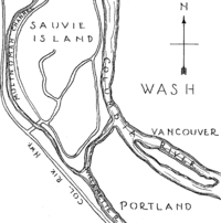
Sauvie Island
Encyclopedia
U.S. state
A U.S. state is any one of the 50 federated states of the United States of America that share sovereignty with the federal government. Because of this shared sovereignty, an American is a citizen both of the federal entity and of his or her state of domicile. Four states use the official title of...
of Oregon
Oregon
Oregon is a state in the Pacific Northwest region of the United States. It is located on the Pacific coast, with Washington to the north, California to the south, Nevada on the southeast and Idaho to the east. The Columbia and Snake rivers delineate much of Oregon's northern and eastern...
, originally Wapato Island or Wappatoo Island, is the largest island
Island
An island or isle is any piece of sub-continental land that is surrounded by water. Very small islands such as emergent land features on atolls can be called islets, cays or keys. An island in a river or lake may be called an eyot , or holm...
along the Columbia River
Columbia River
The Columbia River is the largest river in the Pacific Northwest region of North America. The river rises in the Rocky Mountains of British Columbia, Canada, flows northwest and then south into the U.S. state of Washington, then turns west to form most of the border between Washington and the state...
, at 26,000 acres (105 km²), and the largest river island in the United States. It lies approximately ten miles northwest of downtown Portland
Portland, Oregon
Portland is a city located in the Pacific Northwest, near the confluence of the Willamette and Columbia rivers in the U.S. state of Oregon. As of the 2010 Census, it had a population of 583,776, making it the 29th most populous city in the United States...
, between the Columbia River to the east, the Multnomah Channel
Multnomah Channel
Multnomah Channel is a distributary of the Willamette River that splits from the main stem a few miles upstream of the Willamette's convergence with the Columbia River in Multnomah County in the U.S. state of Oregon. The channel flows northwest then north around Sauvie Island for about to meet the...
to the west, and the Willamette River
Willamette River
The Willamette River is a major tributary of the Columbia River, accounting for 12 to 15 percent of the Columbia's flow. The Willamette's main stem is long, lying entirely in northwestern Oregon in the United States...
to the south. Sturgeon Lake
Sturgeon Lake (Oregon)
Sturgeon Lake is a lake on Sauvie Island in the U.S. state of Oregon. It is particularly notable in that it is the largest lake on the largest fluvial island in the United States and occupies quite a large area of that island....
, in the north central part of the island, is the most prominent water feature. The land area is 84.82 km² (32.75 sq mi, or 20,959 acre
Acre
The acre is a unit of area in a number of different systems, including the imperial and U.S. customary systems. The most commonly used acres today are the international acre and, in the United States, the survey acre. The most common use of the acre is to measure tracts of land.The acre is related...
s), which is larger than Manhattan
Manhattan
Manhattan is the oldest and the most densely populated of the five boroughs of New York City. Located primarily on the island of Manhattan at the mouth of the Hudson River, the boundaries of the borough are identical to those of New York County, an original county of the state of New York...
. Most of the island is in Multnomah County
Multnomah County, Oregon
Multnomah County is one of 36 counties in the U.S. state of Oregon. Though smallest in area, it is the most populous as its county seat, Portland, is the state's largest city...
, but the northern third is in Columbia County
Columbia County, Oregon
Columbia County is a county located in the U.S. state of Oregon. It was named for the Columbia River, which forms its eastern and northern borders. As of 2010, its population was 49,351. The county seat is St. Helens.-Economy:...
. The Sauvie Island Bridge
Sauvie Island Bridge
The Sauvie Island Bridge crosses the Multnomah Channel of the Willamette River near Portland, Oregon, United States. The original Parker truss bridge, built in 1950 with a main span, was replaced with a tied arch bridge with a span in 2008 due to cracks discovered in 2001.-Old bridge:Opened on...
provides access across the Multnomah Channel from U.S. Route 30 and was completed in June, 2009, replacing the first bridge to connect the island to the mainland which was opened on 30 December 1950.
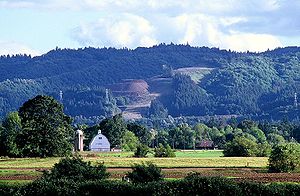
The island is predominantly farmland and wildlife refuge and is a popular place for picking pumpkins, hunting geese and kayaking. There were 1,078 year-round residents at the 2000 census
United States Census, 2000
The Twenty-second United States Census, known as Census 2000 and conducted by the Census Bureau, determined the resident population of the United States on April 1, 2000, to be 281,421,906, an increase of 13.2% over the 248,709,873 persons enumerated during the 1990 Census...
. There is an industrial zone and small grocery store in the southeast corner, near the bridge. Bicyclists flock to the island because its flat topography and lengthy low-volume roads make it ideal for cycling. Its nearest incorporated neighbors are the Portland-Vancouver
Vancouver, Washington
Vancouver is a city on the north bank of the Columbia River in the U.S. state of Washington. Incorporated in 1857, it is the fourth largest city in the state with a 2010 census population of 161,791 as of April 1, 2010...
metropolitan area to its south and southeast; St. Helens
St. Helens, Oregon
St. Helens is the county seat of Columbia County, Oregon. It was founded by Captain H. M. Knighton, a native of New England, in 1845 as "Plymouth". The name was changed to St. Helens in the latter part of 1850 for its view of Mount St. Helens some away in Washington. The population was 10,019 at...
across the Multnomah Channel from the extreme northern tip of the island; and Scappoose
Scappoose, Oregon
Scappoose is a city in Columbia County, Oregon, United States. It was named for a nearby stream, which drains the southern part of the county...
, across the Multnomah Channel to the west.
History
- 1792 - British Lieutenant William BroughtonWilliam Robert BroughtonWilliam Robert Broughton was a British naval officer in the late 18th century. As a Lieutenant in the Royal Navy, he commanded HMS Chatham as part of the Vancouver Expedition, a voyage of exploration through the Pacific Ocean led by Captain George Vancouver in the early 1790s.-With Vancouver:In...
in George VancouverGeorge VancouverCaptain George Vancouver RN was an English officer of the British Royal Navy, best known for his 1791-95 expedition, which explored and charted North America's northwestern Pacific Coast regions, including the coasts of contemporary Alaska, British Columbia, Washington and Oregon...
's expedition explores the island and names the northern tip "Warrior Point" after being greeted offshore by 23 canoes of armed Multnomah Indians. - October 29 - Mount HoodMount HoodMount Hood, called Wy'east by the Multnomah tribe, is a stratovolcano in the Cascade Volcanic Arc of northern Oregon. It was formed by a subduction zone and rests in the Pacific Northwest region of the United States...
was named on October 29, 1792, as Lt. Broughton observed its peak from Belle Vue Point at the southern tip of Sauvie Island during his travels up the Columbia River, writing A very high, snowy mountain now appeared rising beautifully conspicuous in the midst of an extensive tract of low or moderately elevated land (location of today's Vancouver, Washington) lying S 67 E., and seemed to announce a termination to the river. Lt. Broughton named the mountain after British admiral Samuel HoodSamuel Hood, 1st Viscount HoodSamuel Hood, 1st Viscount Hood was a British Admiral known particularly for his service in the American War of Independence and French Revolutionary Wars...
. - November 4, 1805 - The Lewis and Clark expedition lands, names it "Wapato Island" after the abundance of Broadleaf arrowheadBroadleaf arrowheadIndoor plantSagittaria latifolia is a plant found in shallow wetlands and is sometimes known as broadleaf arrowhead, duck potato, Indian potato, or wapato...
plants, which are also known as "Indian potato" and were a major foodstuff for indigenous peoples in the Pacific Northwest. - 1832 - Much of the nativeNative Americans in the United StatesNative Americans in the United States are the indigenous peoples in North America within the boundaries of the present-day continental United States, parts of Alaska, and the island state of Hawaii. They are composed of numerous, distinct tribes, states, and ethnic groups, many of which survive as...
population dies in an epidemic; Hudson's Bay CompanyHudson's Bay CompanyThe Hudson's Bay Company , abbreviated HBC, or "The Bay" is the oldest commercial corporation in North America and one of the oldest in the world. A fur trading business for much of its existence, today Hudson's Bay Company owns and operates retail stores throughout Canada...
at Fort VancouverFort VancouverFort Vancouver was a 19th century fur trading outpost along the Columbia River that served as the headquarters of the Hudson's Bay Company in the company's Columbia District...
removes survivors and burns settlements. - 1834 - American Nathaniel Jarvis WyethNathaniel Jarvis WyethNathaniel Jarvis Wyeth was an American inventor, ice harvester, and explorer and trader in the far west.-Early life:Wyeth was born in Cambridge, Massachusetts, to Jacob and Elizabeth Wyeth...
builds and occupies Fort WilliamFort William (Oregon)Fort William was a fur trading outpost built by American Nathaniel Jarvis Wyeth in 1834. It was located on the Columbia River on Wappatoo Island in what is now part of Portland, Oregon. It was the site of a murder and the first Euro-American trial in what is now the state of Oregon...
, a small trading post, to compete with the British; abandoned 1836. - c. 1836 - Hudson's Bay Company establishes dairies on the island, managed by French-Canadian employee Laurent Sauvé (after whom the island is now named).
- 1851 - Mouth of Willamette post office is established; renamed Souvies Island the following year.
- 1858 - James Bybee builds Bybee–Howell HouseBybee–Howell HouseThe Bybee–Howell House is a historic house, located on Sauvie Island , Oregon, United States. It is listed on the National Register of Historic Places. As of 2010, it is part of Howell Territorial Park, administered by the Metro regional government.-External links:*, from the Historic American...
. The structure was added to the NRHPNational Register of Historic PlacesThe National Register of Historic Places is the United States government's official list of districts, sites, buildings, structures, and objects deemed worthy of preservation...
in 1974, and is part of Howell Territorial Park.
- 1889 - Warrior Rock LightWarrior Rock LightWarrior Rock Light is a lighthouse on Sauvie Island in the U.S. state of Oregon, which helps guide river traffic on the Columbia River around the Portland, Oregon area. It once contained the Pacific Northwest's oldest fog bell...
house established at Warrior Point. - 1930s - The Army Corps of Engineers builds flood-control dikes.
- 1940s - Sauvie Island Wildlife AreaSauvie Island Wildlife AreaThe Sauvie Island Wildlife Area is a state game management area on Sauvie Island in the U.S. state of Oregon. It contains more than .-References:...
acquired by the state of Oregon. - November 29, 1943 - Sauvie Island Conservation District is formed by unanimous vote.
- December 30, 1950 - Sauvie Island Bridge opens; Sauvie Island Ferry closes.
- 2006 - Multnomah County begins construction of new Sauvie Island Bridge.
- 2009 - New Sauvie Island Bridge opens with a parade and a performance by the Oregon Crusaders Drum and Bugle Corps.
Recreational beaches
Reeder Beach does not have public beach access. All public beaches on Sauvie Island are down the road from Reeder Beach approximately four miles. They are: Walton Beach, North Unit Beach, and the clothing-optionalNude beach
A nude beach is a beach where users are legally at liberty to be nude. Sometimes the terms clothing-optional beach or free beach are used. Nude bathing is one of the most common forms of nudity in public. As beaches are usually on public lands, any member of the public is entitled to use the...
Collins Beach
Collins Beach (Sauvie Island)
thumb|Collins BeachCollins Beach is a sandy beach on the Columbia River side of Sauvie Island in Oregon, United States, located north of Portland....
on the island's east coast along NW Reeder Road's last few miles past the end of the pavement. The beaches are open from dawn to 10:00 p.m., and are closed to overnight use and camping. Open fires are not allowed. Dogs are allowed if they are leashed. The north end of Collins Beach is popular among gays and lesbians. This section of the beach is often a party like environment on warm and sunny days.
Beach parking is subject to Sauvie Island Wildlife Area parking permits. They are available at all the stores on the island. Vehicles without a permit are subject to a ticket costing around $75.
External links
- Multnomah County's Rural Area Plan for the island
- Sauvie Island Wildlife Area, from the website of the Oregon Department of Fish and Wildlife
- The Bybee House on Sauvie's Island, from the Historic American Buildings Survey at the Library of CongressLibrary of CongressThe Library of Congress is the research library of the United States Congress, de facto national library of the United States, and the oldest federal cultural institution in the United States. Located in three buildings in Washington, D.C., it is the largest library in the world by shelf space and...
- Sauvie Island, Oregon section of Lyn Topinka's photo essay Lewis & Clark's Columbia River
- Collins Beach site about Sauvie Island's clothing optional beach from the Oregon Clothing-Optional Beach Alliance