

Springwater Corridor
Encyclopedia
Bicycle
A bicycle, also known as a bike, pushbike or cycle, is a human-powered, pedal-driven, single-track vehicle, having two wheels attached to a frame, one behind the other. A person who rides a bicycle is called a cyclist, or bicyclist....
and pedestrian
Pedestrian
A pedestrian is a person traveling on foot, whether walking or running. In some communities, those traveling using roller skates or skateboards are also considered to be pedestrians. In modern times, the term mostly refers to someone walking on a road or footpath, but this was not the case...
rail trail
Rail trail
A rail trail is the conversion of a disused railway easement into a multi-use path, typically for walking, cycling and sometimes horse riding. The characteristics of former tracks—flat, long, frequently running through historical areas—are appealing for various development. The term sometimes also...
in the Portland metropolitan area
Portland metropolitan area
The Portland-Vancouver-Hillsboro, OR-WA Metropolitan Statistical Area , also known as the Portland metropolitan area or Greater Portland, is an urban area in the U.S. states of Oregon and Washington centered around the city of Portland, Oregon. The U.S...
in Oregon
Oregon
Oregon is a state in the Pacific Northwest region of the United States. It is located on the Pacific coast, with Washington to the north, California to the south, Nevada on the southeast and Idaho to the east. The Columbia and Snake rivers delineate much of Oregon's northern and eastern...
, United States
United States
The United States of America is a federal constitutional republic comprising fifty states and a federal district...
. It follows a former railway line of the same name in its route from Boring
Boring, Oregon
Boring is an unincorporated community located in Clackamas County, Oregon, United States, on Oregon Route 212. It is approximately eight miles south of Gresham and about the same distance from Clackamas, both suburbs of Portland. The town is roughly twenty-two miles southeast from downtown...
, through Gresham
Gresham, Oregon
- Demographics :As of the census of 2000, there were 90,205 people, 33,327 households, and 22,695 families residing in the city. The population density was 4,071.6 people per square mile . There were 35,309 housing units at an average density of 1,593.8 per square mile...
, to Portland
Portland, Oregon
Portland is a city located in the Pacific Northwest, near the confluence of the Willamette and Columbia rivers in the U.S. state of Oregon. As of the 2010 Census, it had a population of 583,776, making it the 29th most populous city in the United States...
, where it ends near the Eastbank Esplanade
Eastbank Esplanade
The Eastbank Esplanade is a pedestrian and bicycle path along the east shore of the Willamette River in Portland, Oregon, United States...
. A large segment also roughly follows the course of Johnson Creek
Johnson Creek (Willamette River)
Johnson Creek is a 25-mile tributary of the Willamette River in the Portland metropolitan area of the U.S. state of Oregon. Part of the drainage basin of the Columbia River, its watershed consists of of mostly urban land occupied by about 175,000 people as of 2006...
, and crosses it on bridges many times. Much of the corridor was acquired by the City of Portland
Government of Portland, Oregon
The Government of Portland, Oregon, a city in the U.S. state of Oregon, is based on a city commission government system. Elected officials include a Mayor, a City Council, and a City Auditor. The mayor and commissioners are responsible legislative policy and oversee the various bureaus that...
in 1990; remaining segments were acquired by Metro
Metro (Oregon regional government)
Metro, formerly known as Metropolitan Service District, is the regional governmental agency for the Oregon portion of the Portland metropolitan area...
thereafter.
The trail is part of the Portland area's 40 Mile Loop
40 Mile Loop
The 40-Mile Loop is a partially completed greenway trail around and through Portland in the U.S. State of Oregon. It was proposed in 1903 by the Olmsted Brothers architecture firm as part of the development of Forest Park....
trail system. It connects to many adjacent or nearby parks, including Tideman Johnson Natural Area
Tideman Johnson Natural Area
Tideman Johnson Natural Area is a city park of about in southeast Portland, in the U.S. state of Oregon. Located at Southeast 37th Avenue and Tenino Street along Johnson Creek, the site is named for a mid-19th century family named Johnson that encouraged public use of its land along the...
, Powell Butte
Powell Butte
Powell Butte is an extinct volcanic cinder cone butte in Portland, Oregon, United States. It is one of four such cones inside the city that are home to a city park and is part of the Boring Lava Field, an area of extinct volcanoes. Powell Butte hosts the Powell Butte Nature Park.- External links...
, and others.
History
The Springwater Division rail line was named for a planned connection to Springwater, OregonSpringwater, Oregon
Springwater is an unincorporated rural community in Clackamas County, Oregon, United States, about three miles south of Estacada on Oregon Route 211. So-named since pioneer days, it was one of the first places on the upper Clackamas River to have a post office. Springwater post office ran from...
.
The Portland Traction Company operated rail service from Portland to Boring from 1903 until 1989. Passenger service peaked in 1906 and ended in 1958. Oaks Amusement Park
Oaks Amusement Park
Oaks Park is a small amusement park located south of downtown Portland, Oregon USA, near the Sellwood Bridge. The park includes midway games, about two dozen rides that operate seasonally, a skating rink that is open all-year, and picnic grounds.- Rides :...
—and five other city parks—were built to encourage weekend passenger traffic. Freight trains brought farm produce into Portland.
When ODOT began a project to widen Oregon Highway 99E, a new, expensive overpass was required for the rail line. Citing low traffic volumes, construction was refused and the line was put up for sale. This was of great interest to the 40-Mile Loop Trust, a conservation effort formed in 1981 to build a trail around Portland connecting its many parks, planned since 1904, but had made little progress. The Trust had proven effective at getting many key governmental agencies to work with each other. They called upon the Southern Pacific and Union Pacific railroads, co-owners of the abandoned line, to transfer the land to the Trust. This matter was subject of a battle between on-line railroad shippers and Metro
Metro (Oregon regional government)
Metro, formerly known as Metropolitan Service District, is the regional governmental agency for the Oregon portion of the Portland metropolitan area...
. However, by 1990, the deal was completed, and represented a significant step in the completion of the Loop.
During master planning in 1991 for conversion, the projected use of the corridor was 400,000 people annually, distributed as 56% bicycling, 36% walking, 9% jogging, and 3% equestrian. By 2003, usage was expected to exceed one million users per year.
Prior to paving, much of the trail was suitable for mountain biking.
Construction of the east-west segment of the trail between Oregon Highway 99E and Gresham was completed in 1996. An additional mile east of Gresham was built in 2000. In 2005, a 3-mile north-south "Springwater on the Willamette" segment opened between central Portland and the Sellwood Bridge
Sellwood Bridge
The Sellwood Bridge is a truss bridge that spans the Willamette River in Portland, Oregon, in the United States. It was Portland's first fixed-span bridge and, being the only river crossing for miles in each direction, is the busiest two-lane bridge in Oregon...
along the Willamette River. Unlike the other sections of the trail, the rail line remained, separated by a fence. The line is currently operated by the Oregon Pacific Railroad.
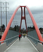
The last significant section of the trail was completed ahead of schedule in summer 2006, when the construction of three new bridges over Johnson Creek, Oregon Highway 99E and a railroad line, allowing users to cross them without having to detour and mix with traffic on busy streets.
As of 2011, a one-mile gap in the Sellwood
Sellwood, Portland, Oregon
Sellwood-Moreland is a neighborhood on a bluff overlooking the Willamette River in Southeast Portland, Oregon, bordering Westmoreland to the north, Eastmoreland to the east, and the city of Milwaukie to the south...
area remains but is planned to be reduced. This segment was one of the parks and trails recommended for funding by a Metro advisory panel in 2001.
In 2003, Portland was one of 25 cities that received a $200,000 grant from Active Living by Design to promote urban planning that encourages physical activity. Some of the money was allocated to a Lents Station interpretive trailhead along the Springwater Corridor.
In 2006, the City of Portland rejected a development proposal for a property that did not include an easement
Easement
An easement is a certain right to use the real property of another without possessing it.Easements are helpful for providing pathways across two or more pieces of property or allowing an individual to fish in a privately owned pond...
for a greenway
Greenway (landscape)
A greenway is a long, narrow piece of land, often used for recreation and pedestrian and bicycle user traffic, and sometimes for streetcar, light rail or retail uses.- Terminology :...
along the Willamette River
Willamette River
The Willamette River is a major tributary of the Columbia River, accounting for 12 to 15 percent of the Columbia's flow. The Willamette's main stem is long, lying entirely in northwestern Oregon in the United States...
, and would have prevented completion of a planned connection between the Springwater Trail and the Eastbank Esplanade.
The easement requirement was upheld by the Oregon Court of Appeals on February 13, 2008.
The trail is gravel from Rugg Road to Boring. There is a proposal to continue this trail to connect the 40 Mile Loop to the Pacific Crest Trail
Pacific Crest Trail
The Pacific Crest Trail is a long-distance mountain hiking and equestrian trail on the Western Seaboard of the United States. The southern terminus is at the California border with Mexico...
.
External links
- The Abandoned Portland Traction Company Springwater Division & the Boring Branch from Abandoned Railroads of the Pacific Northwest
- Photos and description of Springwater Trail
- Video on volunteers working with the Lents Springwater Habitat Restoration Project