

Johnson Creek (Willamette River)
Encyclopedia
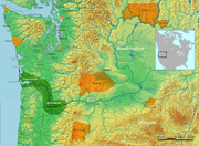
Johnson Creek is a 25-mile (40 km) tributary of the Willamette River
in the Portland metropolitan area
of the U.S. state of Oregon
. Part of the drainage basin
of the Columbia River
, its watershed consists of 54 square miles (139.9 km²) of mostly urban land occupied by about 175,000 people as of 2006. Passing through the cities of Gresham
, Portland
, and Milwaukie
, the creek flows generally west from the foothills of the Cascade Range
through sediments deposited by glacial floods on a substrate of basalt
. Though polluted, it is free-flowing along its main stem and provides habitat for salmon
and other migrating fish
.
Prior to European settlement, the watershed was heavily forested and was used by Native Americans
of the Chinook band
for fishing and hunting. In the 19th century, white settler
s cleared much of the land for farming, and the stream is named for one of these newcomers, William Johnson, who in 1846 built a water-powered sawmill
along the creek. By the early 20th century, a rail line parallel to the stream encouraged further residential and commercial development. As urban density increased in the floodplain, seasonal floods grew more damaging. In the 1930s the Works Progress Administration
of the federal government lined the lower 15 miles (24.1 km) of Johnson Creek with rock to control the floods. Despite this, the creek flooded 37 times between 1941 and 2006. Since the 1990s, regional planners have tried to reduce flooding by controlling stormwater
runoff
, creating stream meander
s, reducing erosion
, replacing impervious surfaces, and protecting riparian buffers.
The Johnson Creek watershed includes the subwatersheds of Badger Creek, Sunshine Creek, Kelley Creek, Mitchell Creek, Veterans Creek, Crystal Springs Creek, and smaller streams. Parks along the creek and its tributaries include natural areas, a wildlife refuge, a rhododendron
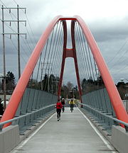
garden, a botanical garden, and a 21 miles (33.8 km) bicycle and pedestrian rail trail
that follows the creek for much of its length.
, in Clackamas County, Oregon
, southeast of Gresham
in the foothills of the Cascade Range
, and flows generally westward about 25 miles (40 km) to its confluence with the Willamette River
, a major tributary of the Columbia River
. The creek passes through the cities of Gresham, Portland
, and Milwaukie
and crosses the border between Clackamas County and Multnomah County
eight times.
For much of its course, the creek flows at almost right angles to the numbered avenues of southeast Portland and its eastern suburbs. The biggest numbers are near the headwaters, and the smallest numbers are near the mouth. The creek begins in uplands in Clackamas County east of Southeast 362nd Avenue and flows swiftly to the west for about 5 miles (8 km), crisscrossing the border between Clackamas County and Multnomah County 5 times in this upstream stretch, and passing under U.S. Route 26, the Mount Hood Highway
, in Multnomah County at about 20 miles (32.2 km) from the mouth. Shortly thereafter, it receives Badger Creek and Sunshine Creek from the left and the North Fork of Johnson Creek from the right.
Turning sharply, Johnson Creek flows swiftly northwest for about 3 miles (4.8 km), entering Gresham and shortly thereafter passing the United States Geological Survey
(USGS) gauge at Regner Road, 16.2 miles (26.1 km) from the mouth.
Soon the creek enters Main City Park in Gresham, where it again turns sharply and flows slightly south of west. Here the slope flattens, and the stream runs more slowly for the next third of its course. Slightly west of Main City Park, it passes the Gresham Pioneer Cemetery
. Just beyond the cemetery, it receives Butler Creek on the left, enters Portland at about 13 miles (20.9 km) from the mouth, and receives Kelley Creek on the left shortly thereafter. Mitchell Creek, a major tributary of Kelley Creek, enters Kelley Creek about 0.5 mile (0.80467 km) south of Johnson Creek. Shortly thereafter, Johnson Creek passes the USGS gauge station at Sycamore, 10.2 miles (16.4 km) from the mouth.
Meander
ing slowly through the Lents
neighborhood of Portland, Johnson Creek receives Veterans Creek, which enters on the left from its headwaters in Happy Valley
in Clackamas County. Johnson Creek passes under Interstate 205
, and shortly thereafter begins to flow more swiftly again at Southeast 82nd Avenue, about 8 miles (12.9 km) from the mouth. It then makes its sixth and seventh county-border crossings, dipping briefly into Clackamas County and back north into Multnomah County, and then runs near the border between Portland and Milwaukie along Johnson Creek Boulevard for about 2 miles (3.2 km). After passing under Oregon Route 99E (Southeast McLoughlin Boulevard) in Portland's Sellwood
neighborhood, the creek turns sharply south about 1.5 miles (2.4 km) from the mouth.
At Southeast 21st Avenue, it receives Crystal Springs Creek
, which enters on the right. This tributary, 2.7 miles (4.3 km) long, begins on the Reed College
campus, flows under the Blue Bridge
in Reed Canyon, through the Crystal Springs Rhododendron Garden
, and generally south to Johnson Creek. From its confluence with Crystal Springs Creek, Johnson Creek flows south about 1 miles (1.6 km), crossing the county border for the eighth and final time. After re-entering Clackamas County, it passes the USGS gauge station at Milwaukie, 0.7 miles (1.1 km) from the mouth. Shortly thereafter, Johnson Creek empties into the Willamette River 18.5 miles (29.8 km) above its confluence with the Columbia River, which in turn flows about another 100 miles (160.9 km) to the Pacific Ocean at Astoria
.
of Johnson Creek is a remnant of large glacial floods known as the Missoula Floods
that deposited thick sediment
s between 13,000 and 15,000 years ago in the Columbia River Basin
, including much of the Willamette Valley
. Underlying the sediments are substantial thicknesses of basalt
lavas from the Columbia River Basalt Group
. The lava, exposed mainly in the uplands, has been folded and faulted to form a series of sub-basins, including the Johnson Creek watershed.
The watershed is a roughly rectangular area of about 54 square miles (139.9 km²). The topography of the watershed varies greatly from the high point of about 1100 feet (335 m) above sea level in the Boring Hills near the creek's source to the low point of 26 feet (8 m) where the creek meets the Willamette River.
Slopes in the watershed range generally between 1 and 25 percent. Mount Scott
and Powell Butte
rise to about 1000 feet (305 m) and have slopes ranging from 10 to 30 percent. Gresham Butte and Hogan Butte, in Gresham, have the steepest slopes, including a few around 50 percent. The Boring Hills, of volcanic origin, rise more than 800 feet (244 m) higher than the terraces to the north and west. The Kelso Slope, a northwest-sloping dissected surface
west of the canyon of the Sandy River
, tilts down from about 1000 feet (305 m) above sea level near Sandy
to about 400 feet (122 m) above sea level east of Gresham.
Formed by the ancestral Columbia and Willamette Rivers, the terraces
north of Johnson Creek are generally underlain by permeable sand and gravel. Three isolated hills—Rocky Butte
, Mount Tabor
, and Kelly Butte—rise about 200 feet (61 m) to 400 feet (122 m) above the surrounding terraces. With the exception of Powell Butte, the terrain on the north side of Johnson Creek is less steep than on the south side of the creek, which includes Mount Scott and the Boring Lava Domes
.
The eastern half of the watershed is more open and rural than the urban western half, which consists largely of residential areas with pockets of commerce and industry. An estimated 175,000 people lived in the watershed as of 2006.
varies throughout the watershed. Erosion is not a big threat in the northwestern part of the watershed, where the land is flat and developed, or in the northeast, dominated by low-erosion soils. In the southeast, soils have a medium risk of erosion, and soils around Powell Butte and the Boring Lava Domes have "an extremely high erodibility factor and are sensitive to ground disturbance".
The watershed's soils vary in their permeability and water-retaining capacity. South of the creek and at the eastern end of the watershed they consist mostly of clays with high runoff potential. Northern areas of the watershed are generally porous, with moderate to high permeability.
rates. The northern area, comprising about 40 percent of the watershed, consists of the Portland Terraces, and the southern consists of the Boring Hills and the Kelso Slope. Most of the rain that falls on the northern area percolates into the ground, and most of the rain that falls on the southern area runs quickly into the creek or its tributaries. Rain that falls on the north generally has a more gradual, longer-lasting effect, sustaining the base flow
of the creek during dry periods.
Of the estimated 30 creek systems that existed in the watershed before 19th-century settlement, fewer than a dozen remain above-ground or free-flowing. Generally, the tributaries begin south of the main stem and flow north; the major exception is Crystal Springs Creek, which begins as a groundwater
discharge and flows south over relatively impermeable alluvial deposits to Johnson Creek at Johnson Creek Park. The other major tributaries are Veterans Creek, Kelley Creek, Butler Creek, Sunshine Creek, and Badger Creek. Crystal Springs Creek and Kelley Creek are the largest tributaries in terms of flow contribution.
Fill
at Foster Road and Southeast 111th Avenue usually prevents stormwater runoff from a 9 square miles (23.3 km²) area of the watershed in the Lents
and Powellhurst-Gilbert
neighborhoods from flowing directly into the creek. Instead, runoff is routed to sump
s, where it percolates into the ground. Normal drainage patterns have also been altered further downstream in the Sellwood
, Eastmoreland
, Westmoreland
, and Woodstock
neighborhoods, where runoff flows into the Portland sewer system instead of into the creek.
. None of the cities lies entirely within the watershed. In 2000, Johnson Creek and its tributaries drained 53 percent of Gresham, 42 percent of Milwaukie, 19 percent of Happy Valley, and 14 percent of Portland. The watershed covered only 1.2 percent of unincorporated Multnomah County and less than 1 percent of unincorporated Clackamas County.
Neighboring watersheds on the east side of the Willamette River include Mount Scott Creek and Kellogg Creek, which flow through Milwaukie and drain directly into the Willamette; the Clackamas River, which drains the southeast suburbs and empties into the Willamette near Oregon City
; the Sandy River
, which drains the eastern suburbs and empties into the Columbia; and Fairview Creek and the Columbia Slough
, which drain north Portland and Gresham, emptying into the Columbia.
Nineteenth-century maps also show numerous springs and small streams flowing into a wetland that covered an area of today's southeast Portland between Powell Boulevard (U.S. Route 26
) and Johnson Creek, a distance of 2.25 miles (3.6 km). Though most of the wetland complex has been filled in and built upon, remnants exist at the Crystal Springs Rhododendron Garden
on Crystal Springs Creek. Old maps also show two streams flowing into a slough that drained part of the wetland. One flowed through the Clinton Street neighborhood, about six city blocks north of Powell Boulevard, and the other drained the Colonial Heights neighborhood, slightly further north near Ladd's Addition
. These streams and most others in this area were diverted into the city sewer system and no longer appear on the surface. A Johnson Creek diverted partly underground on the west side of the Willamette River in Portland has no relationship to the Johnson Creek on the east side.
 Before settlers moved into the basin, it consisted mainly of upland and wetland
forests in which Native Americans
fished, hunted, and foraged. Evidence suggests that people lived in the northern Oregon Cascades
as early as 10,000 years ago. By 2,000 to 3,000 years ago, settlements in the Clackamas River
basin, adjacent to the Johnson Creek watershed, had moved to the river's lower floodplain. The area was the home of the Clackamas Indians, a subgroup of the Chinookan
speakers who lived in the Columbia River Valley from Celilo Falls
to the Pacific Ocean. The Clackamas lands included the lower Willamette River from Willamette Falls
at what became Oregon City
to its confluence with the Columbia River and reached into the foothills of the Cascades. When Lewis and Clark
visited the area in 1806, the Clackamas tribe consisted of about 1,800 people living in 11 villages. Epidemics of smallpox
, malaria
, and measles
reduced this population to 88 by 1851, and in 1855 the tribe signed a treaty surrendering its lands, including Johnson Creek.
By the middle of the 19th century, the European American
newcomers had begun to remove vegetation, build sawmills, fell trees, fill wetlands, and farm in the fertile soil along Johnson Creek. The creek is named for one of these newcomers, William Johnson, who in 1846 settled in what later became the Lents neighborhood of Portland and operated a water-powered sawmill. In early 1848 Lot Whitcomb, who would later found Milwaukie
, filed a donation land claim
and built a sawmill near the confluence of Johnson Creek and the Willamette River. In 1886, plans were made for train tracks along the creek. In 1903, the Springwater Division Line, also known as the Portland Traction Company Line, the Cazadero Line, and the Bellrose Line, was built along Johnson Creek to provide rail transport for passengers and freight. Sellwood, Eastmoreland, Lents, and Pleasant Valley
were among the new communities that grew up along the line. By the 1920s, housing began to replace creekside farms, a trend that has continued.
of the federal government
cleared and lined with rock about 90 percent of the creek between its mouth and Southeast 158th Avenue, about 15 miles (24.1 km) from the mouth, creating an artificial channel 6 feet (2 m) to 10 feet (3 m) deep and 25 feet (8 m) to 50 feet (15 m) wide. Although substantially altering the stream and its aquatic life, this channel failed to prevent overflows, the largest of which damaged 1,200 structures in 1964.
Precipitation patterns in the Johnson Creek watershed have contributed to frequent high flows and floods along the creek, typically between November and February.
Based on records from 1961 to 1990, Portland's average annual precipitation, as measured at Portland International Airport
along the Columbia River, is about 36 inches (914.4 mm). About 21 inches (533.4 mm) falls from November through February and only about 4 inches (101.6 mm) from June through September. The airport, at about 30 feet (9 m) above sea level, is at essentially the same elevation as the mouth of Johnson Creek. Annual precipitation at higher elevations in the creek's upper watershed is much higher, more than 70 inches (1,778 mm).
The floods primarily affect four areas in Portland: Tideman-Johnson Park at Southeast 45th Avenue, the area west of Southeast 82nd Avenue; Lents, and lower Powell Butte. The U.S. National Weather Service
defines Johnson Creek's flood stage, measured at USGS station 14211500 at Sycamore in Portland, as 11 feet (3.4 m), equivalent to a flow rate (discharge rate) of about 1200 cubic feet (34 m³) per second. The USGS peak streamflow data collected by the stream gauge
at that station show that the creek reached or exceeded 1200 cubic feet (34 m³) per second 37 times between 1941 and 2006; that is 37 floods in 65 years. Twenty of those floods exceeded 1500 cubic feet (42.5 m³) per second. At least seven of the floods caused major property damage. A more recent overflow occurred in December 2007, when the creek crested at 1.5 foot (0.4572 m) above flood stage. Between 1978 and 1997, flood insurance claims totaling an estimated $2 million were paid for damage along the creek.
The biggest flood measured at Sycamore, 10.2 miles (16.4 km) from the mouth of the creek, occurred in 1996. Exceeding the official flood stage of 11 feet (3.4 m) by more than 4 feet (1.2 m), the creek reached 15.3 feet (4.7 m) on November 19 of that year. The second biggest flood occurred on December 22, 1964
, when the creek reached 14.68 feet (4.5 m) at Sycamore.
As of 2008, the USGS was monitoring Johnson Creek at Regner Road in Gresham, 16.3 miles (26.2 km) from the mouth, and at Milwaukie, 0.7 miles (1.1 km) from the mouth, as well as at Sycamore. It also had stream-monitor stations on Kelley Creek and Crystal Springs Creek. The Sycamore station was the oldest, having begun operation in 1941.
Proposals by agencies such as Metro
, the regional government of the Portland metropolitan area, and the U.S. Army Corps of Engineers
in the 1970s and 1980s to control Johnson Creek flooding were abandoned after groups of residents objected to every proposal. In 1990, the City of Portland
formed the Johnson Creek Corridor Committee from multiple agencies and citizen groups with varied interests related to the watershed. Led by the city's Bureau of Environmental Services, the combined groups in 2001 produced the Johnson Creek Restoration Plan to reduce flooding, improve water quality, and improve fish and wildlife habitat. Goals varied from section to section along the creek and included controlling storm water runoff, reducing erosion, replacing or mitigating impervious surfaces, and protecting riparian
zones. Through 2007, at least 75 site-specific restoration projects had been carried out in the Johnson Creek Watershed, ranging from the $1.2-million Brookside Project, a constructed wetland, to small riparian repair projects. Most involved voluntary citizen participation in all phases, including the long-term management and care of the sites.
(DEQ) rated Johnson Creek's water quality between 1986 and 1995 as "very poor". Monitoring the creek 0.2 mile (0.321868 km) from the mouth, it recorded very high concentrations of nitrate
s and high concentrations of phosphate
s. Fecal coliform bacteria
, total solids, and biochemical oxygen demand
also impaired water quality. These conditions occurred throughout the year, and results for each parameter fell into the "very poor" category. On the Oregon Water Quality Index (OWQI) used by DEQ, water quality scores can vary from 10 (worst) to 100 (ideal). The minimal seasonal average for Johnson Creek on this scale was 26, the second worst in the lower Willamette basin. By comparison, the minimal seasonal average in the nearby Willamette River at the Hawthorne Bridge
in downtown Portland was 74 during the same years. Studies suggest that most pollutants of Johnson Creek do not come from point sources but are washed off urban and rural land surfaces during storms.
Elevated temperatures cause problems for aquatic life over the whole length of Johnson Creek. The Oregon standard for maximum temperatures conducive to salmonid
rearing in the Willamette Basin is 17.8 °C (64 °F), and data show that the mean maximum summertime temperatures in Johnson Creek exceed this standard. The maximum temperature that Coho salmon can survive for short periods is 24 °C (75.2 °F). Thermographs
at several locations on Johnson Creek in 1992 recorded maximum average weekly water temperatures higher than 18 °C (64.4 °F) in June, July, and August, and an absolute maximum temperature of 24 °C (75.2 °F).
Studies conducted by DEQ, USGS, the City of Gresham, and other public agencies have identified DDT
(dichloro-diphenyl-trichloroethane), dieldrin
, polychlorinated biphenyl
s (PCB), chlordane
, and polycyclic aromatic hydrocarbon
s (PAH) as carcinogenic pollutants of Johnson Creek. The creek has been classified as a “waterbody of concern” by the DEQ because of elevated levels of copper, chromium
, and nickel
in water and sediments. Generally, metal concentrations increase downstream.
found that Johnson Creek had marginal conditions for macroinvertebrates, an important source of food for fish and other aquatic life. The study compared differences in these life forms and in water chemistry from two urban stream
s, Johnson Creek and Tryon Creek
in southwest Portland, with two nearby rural streams and found that benthic
communities in the urban streams were degraded compared to the regional reference creeks.
Most fish species in Johnson Creek tolerate warm water and disturbed conditions. These include red-sided shiners
, sculpin
, suckers
, and speckled dace
.
Large populations of salmon
inhabited the creek before urban construction altered the watershed and the stream channel, and in the 21st century, the creek and its tributaries still provide habitat for smaller numbers of Chinook salmon
, Coho salmon
, steelhead
, and cutthroat trout
. As of 2008, Chinook and Coho salmon and steelhead were listed as threatened species in the Lower Columbia River watershed, of which Johnson Creek is part. Under provisions of the federal Endangered Species Act
, a species is "threatened" if it is likely to become endangered, and it is "endangered" if it is likely to become extinct through all or a significant part of its range.
s, black bears, foxes, cougars, wolves, and elk
thrived in the area. Common species in the 21st century include Crow, Robin, Starling, Song Sparrow
, Bewick's Wren
, House Finch
, Cedar Waxwing
, Violet-green Swallow
, Belted Kingfisher
, Great Blue Heron
, Mallard
, Wood Duck
, Bushtit
, Black-capped Chickadee
, raccoon, opossum, nutria
, and moles
. Less developed areas support black-tailed deer, coyotes, deer mice
, vole
s, bats, Western Flycatchers
, Black-headed Grosbeak
s, Orange-crowned Warbler
s, Common Merganser
s, and woodpeckers. Other wildlife in the watershed include beaver
, river otter
, hawks, owls, geese, and an occasional eagle.
Johnson Creek and its watershed are home to life forms that, under Oregon law, have been listed as "sensitive" species. These are naturally reproducing native animals that may become threatened or endangered throughout all or any significant part of their range in Oregon. Such animals known to live in the Johnson Creek watershed include long-toed, northwestern, and Columbia salamander
s, red-legged frogs, painted turtles, great horned owls, toads, hawks, and coyotes. A plant found on Powell Butte, tall bugbane (Actaea elata), is also listed as a sensitive species.
designated by the U.S. Environmental Protection Agency
(EPA). It was covered until the mid-19th century with Oregon ash, red alder, and western redcedar
forests and scattered black cottonwood
groves in riparian areas. Douglas-fir
and Oregon white oak
grew in the uplands. About 57 percent of the watershed is vegetated, including grass, trees, blackberries, and all other plant life. Seventy-two percent of the watershed lies within the urban growth boundary
. Of the total land area, 57 percent is single-family residential, 12 percent multi-family, 10 percent commercial, 8 percent rural, and 13 percent parks and open space. Of the rural agricultural total, 50 percent consists of cultivated crops or pasture, 29 percent tree and ornamental nurseries, 2 percent cultivated cane crops, and 19 percent is unclassified.
Creek restoration projects since the 1990s have reduced the amount of Himalayan blackberry
, an invasive species
that had come to dominate much of the landscape near the creek. New plantings include native shrubs and trees such as red-osier dogwood
, elderberry, Indian plum
, and willow. City parks adjacent to Johnson Creek have areas devoted to marsh with shrubs, cattails
, and smartweed
, forested wetland, riparian woodland, open meadow, and orchard trees.
 By 1960, use of the rail line along Johnson Creek had declined and passenger service was discontinued. By 1990 the City of Portland bought much of the corridor. Working with Metro, it created the Springwater Corridor Trail
, a 21 miles (34 km) bicycle and pedestrian rail trail
that follows the creek and extends from the Willamette River
to Boring
. It became part of the 40 Mile Loop
, a hiking and biking trail that circles the Portland metropolitan area and intersects with similar trails.
Creekside parks include Johnson Creek Park
, about 4.5 acres (18,210.9 m²) of natural areas and paths; the Crystal Springs Rhododendron Garden
, along Crystal Springs Creek; Tideman Johnson Natural Area
, about 7.2 acres (29,137.4 m²) of natural areas and paths; Leach Botanical Garden
, about 16 acres (64,749.8 m²), a public garden dedicated to the study of botany and horticulture with an emphasis on plants of the Pacific Northwest; Beggars Tick Wildlife Refuge, a wetland of 20 acres (80,937.2 m²); Powell Butte Nature Park
, about 608 acres (2.5 km²) on an extinct cinder cone volcano, including natural areas and hiking, biking, and equestrian trails; and Gresham's Main City Park, about 18 acres (72,843.5 m²) including sports fields, picnic areas, and trails.
In 2007 Metro bought two parcels of land totaling 102 acres (412,779.7 m²) for preservation adjacent to Johnson Creek on Clatsop Butte
, south of Foster Road near Powell Butte and Portland's Pleasant Valley
neighborhood. The purchases cost $10.9 million, drawing on bonds approved by a 2006 ballot measure. They were praised by conservationists but questioned by others who thought Metro had paid too much.
Willamette River
The Willamette River is a major tributary of the Columbia River, accounting for 12 to 15 percent of the Columbia's flow. The Willamette's main stem is long, lying entirely in northwestern Oregon in the United States...
in the Portland metropolitan area
Portland metropolitan area
The Portland-Vancouver-Hillsboro, OR-WA Metropolitan Statistical Area , also known as the Portland metropolitan area or Greater Portland, is an urban area in the U.S. states of Oregon and Washington centered around the city of Portland, Oregon. The U.S...
of the U.S. state of Oregon
Oregon
Oregon is a state in the Pacific Northwest region of the United States. It is located on the Pacific coast, with Washington to the north, California to the south, Nevada on the southeast and Idaho to the east. The Columbia and Snake rivers delineate much of Oregon's northern and eastern...
. Part of the drainage basin
Drainage basin
A drainage basin is an extent or an area of land where surface water from rain and melting snow or ice converges to a single point, usually the exit of the basin, where the waters join another waterbody, such as a river, lake, reservoir, estuary, wetland, sea, or ocean...
of the Columbia River
Columbia River
The Columbia River is the largest river in the Pacific Northwest region of North America. The river rises in the Rocky Mountains of British Columbia, Canada, flows northwest and then south into the U.S. state of Washington, then turns west to form most of the border between Washington and the state...
, its watershed consists of 54 square miles (139.9 km²) of mostly urban land occupied by about 175,000 people as of 2006. Passing through the cities of Gresham
Gresham, Oregon
- Demographics :As of the census of 2000, there were 90,205 people, 33,327 households, and 22,695 families residing in the city. The population density was 4,071.6 people per square mile . There were 35,309 housing units at an average density of 1,593.8 per square mile...
, Portland
Portland, Oregon
Portland is a city located in the Pacific Northwest, near the confluence of the Willamette and Columbia rivers in the U.S. state of Oregon. As of the 2010 Census, it had a population of 583,776, making it the 29th most populous city in the United States...
, and Milwaukie
Milwaukie, Oregon
Milwaukie is a city in Clackamas County, Oregon, United States. A very small portion of the city extends into Multnomah County. The population was 20,291 at the 2010 census. Founded in 1848 on the banks of the Willamette River, the city, known as the Dogwood City of the West, was incorporated in...
, the creek flows generally west from the foothills of the Cascade Range
Cascade Range
The Cascade Range is a major mountain range of western North America, extending from southern British Columbia through Washington and Oregon to Northern California. It includes both non-volcanic mountains, such as the North Cascades, and the notable volcanoes known as the High Cascades...
through sediments deposited by glacial floods on a substrate of basalt
Basalt
Basalt is a common extrusive volcanic rock. It is usually grey to black and fine-grained due to rapid cooling of lava at the surface of a planet. It may be porphyritic containing larger crystals in a fine matrix, or vesicular, or frothy scoria. Unweathered basalt is black or grey...
. Though polluted, it is free-flowing along its main stem and provides habitat for salmon
Salmon
Salmon is the common name for several species of fish in the family Salmonidae. Several other fish in the same family are called trout; the difference is often said to be that salmon migrate and trout are resident, but this distinction does not strictly hold true...
and other migrating fish
Fish migration
Many types of fish migrate on a regular basis, on time scales ranging from daily to annually or longer, and over distances ranging from a few metres to thousands of kilometres...
.
Prior to European settlement, the watershed was heavily forested and was used by Native Americans
Native Americans in the United States
Native Americans in the United States are the indigenous peoples in North America within the boundaries of the present-day continental United States, parts of Alaska, and the island state of Hawaii. They are composed of numerous, distinct tribes, states, and ethnic groups, many of which survive as...
of the Chinook band
Chinookan
Chinook refers to several native amercain groups of in the Pacific Northwest region of the United States, speaking the Chinookan languages. In the early 19th century, the Chinookan-speaking peoples lived along the lower and middle Columbia River in present-day Oregon and Washington...
for fishing and hunting. In the 19th century, white settler
Settler
A settler is a person who has migrated to an area and established permanent residence there, often to colonize the area. Settlers are generally people who take up residence on land and cultivate it, as opposed to nomads...
s cleared much of the land for farming, and the stream is named for one of these newcomers, William Johnson, who in 1846 built a water-powered sawmill
Sawmill
A sawmill is a facility where logs are cut into boards.-Sawmill process:A sawmill's basic operation is much like those of hundreds of years ago; a log enters on one end and dimensional lumber exits on the other end....
along the creek. By the early 20th century, a rail line parallel to the stream encouraged further residential and commercial development. As urban density increased in the floodplain, seasonal floods grew more damaging. In the 1930s the Works Progress Administration
Works Progress Administration
The Works Progress Administration was the largest and most ambitious New Deal agency, employing millions of unskilled workers to carry out public works projects, including the construction of public buildings and roads, and operated large arts, drama, media, and literacy projects...
of the federal government lined the lower 15 miles (24.1 km) of Johnson Creek with rock to control the floods. Despite this, the creek flooded 37 times between 1941 and 2006. Since the 1990s, regional planners have tried to reduce flooding by controlling stormwater
Stormwater
Stormwater is water that originates during precipitation events. It may also be used to apply to water that originates with snowmelt that enters the stormwater system...
runoff
Surface runoff
Surface runoff is the water flow that occurs when soil is infiltrated to full capacity and excess water from rain, meltwater, or other sources flows over the land. This is a major component of the water cycle. Runoff that occurs on surfaces before reaching a channel is also called a nonpoint source...
, creating stream meander
Meander
A meander in general is a bend in a sinuous watercourse. A meander is formed when the moving water in a stream erodes the outer banks and widens its valley. A stream of any volume may assume a meandering course, alternately eroding sediments from the outside of a bend and depositing them on the...
s, reducing erosion
Erosion
Erosion is when materials are removed from the surface and changed into something else. It only works by hydraulic actions and transport of solids in the natural environment, and leads to the deposition of these materials elsewhere...
, replacing impervious surfaces, and protecting riparian buffers.
The Johnson Creek watershed includes the subwatersheds of Badger Creek, Sunshine Creek, Kelley Creek, Mitchell Creek, Veterans Creek, Crystal Springs Creek, and smaller streams. Parks along the creek and its tributaries include natural areas, a wildlife refuge, a rhododendron
Rhododendron
Rhododendron is a genus of over 1 000 species of woody plants in the heath family, most with showy flowers...
garden, a botanical garden, and a 21 miles (33.8 km) bicycle and pedestrian rail trail
Rail trail
A rail trail is the conversion of a disused railway easement into a multi-use path, typically for walking, cycling and sometimes horse riding. The characteristics of former tracks—flat, long, frequently running through historical areas—are appealing for various development. The term sometimes also...
that follows the creek for much of its length.
Course
Johnson Creek begins near the unincorporated community of CottrellCottrell, Oregon
Cottrell is an unincorporated crossroads community in north Clackamas County, Oregon, United States. It was named for the family of Mrs. Charles Andrews, whose maiden name was Cottrell. There was a Cottrell post office from 1894 until 1904; it probably closed when Rural Free Delivery was extended...
, in Clackamas County, Oregon
Clackamas County, Oregon
Clackamas County is a county located in the U.S. state of Oregon. The county was named after the Native Americans living in the area, the Clackamas Indians, who were part of the Chinookan people. As of 2010, the population was 375,992...
, southeast of Gresham
Gresham, Oregon
- Demographics :As of the census of 2000, there were 90,205 people, 33,327 households, and 22,695 families residing in the city. The population density was 4,071.6 people per square mile . There were 35,309 housing units at an average density of 1,593.8 per square mile...
in the foothills of the Cascade Range
Cascade Range
The Cascade Range is a major mountain range of western North America, extending from southern British Columbia through Washington and Oregon to Northern California. It includes both non-volcanic mountains, such as the North Cascades, and the notable volcanoes known as the High Cascades...
, and flows generally westward about 25 miles (40 km) to its confluence with the Willamette River
Willamette River
The Willamette River is a major tributary of the Columbia River, accounting for 12 to 15 percent of the Columbia's flow. The Willamette's main stem is long, lying entirely in northwestern Oregon in the United States...
, a major tributary of the Columbia River
Columbia River
The Columbia River is the largest river in the Pacific Northwest region of North America. The river rises in the Rocky Mountains of British Columbia, Canada, flows northwest and then south into the U.S. state of Washington, then turns west to form most of the border between Washington and the state...
. The creek passes through the cities of Gresham, Portland
Portland, Oregon
Portland is a city located in the Pacific Northwest, near the confluence of the Willamette and Columbia rivers in the U.S. state of Oregon. As of the 2010 Census, it had a population of 583,776, making it the 29th most populous city in the United States...
, and Milwaukie
Milwaukie, Oregon
Milwaukie is a city in Clackamas County, Oregon, United States. A very small portion of the city extends into Multnomah County. The population was 20,291 at the 2010 census. Founded in 1848 on the banks of the Willamette River, the city, known as the Dogwood City of the West, was incorporated in...
and crosses the border between Clackamas County and Multnomah County
Multnomah County, Oregon
Multnomah County is one of 36 counties in the U.S. state of Oregon. Though smallest in area, it is the most populous as its county seat, Portland, is the state's largest city...
eight times.
For much of its course, the creek flows at almost right angles to the numbered avenues of southeast Portland and its eastern suburbs. The biggest numbers are near the headwaters, and the smallest numbers are near the mouth. The creek begins in uplands in Clackamas County east of Southeast 362nd Avenue and flows swiftly to the west for about 5 miles (8 km), crisscrossing the border between Clackamas County and Multnomah County 5 times in this upstream stretch, and passing under U.S. Route 26, the Mount Hood Highway
Mount Hood Highway
The Mount Hood Highway No. 26 is the Oregon Department of Transportation's designation for a 93.84-mile highway from Portland east around the south side of Mount Hood and north via Bennett Pass to Hood River. It is marked as U.S...
, in Multnomah County at about 20 miles (32.2 km) from the mouth. Shortly thereafter, it receives Badger Creek and Sunshine Creek from the left and the North Fork of Johnson Creek from the right.
Turning sharply, Johnson Creek flows swiftly northwest for about 3 miles (4.8 km), entering Gresham and shortly thereafter passing the United States Geological Survey
United States Geological Survey
The United States Geological Survey is a scientific agency of the United States government. The scientists of the USGS study the landscape of the United States, its natural resources, and the natural hazards that threaten it. The organization has four major science disciplines, concerning biology,...
(USGS) gauge at Regner Road, 16.2 miles (26.1 km) from the mouth.
Soon the creek enters Main City Park in Gresham, where it again turns sharply and flows slightly south of west. Here the slope flattens, and the stream runs more slowly for the next third of its course. Slightly west of Main City Park, it passes the Gresham Pioneer Cemetery
Gresham Pioneer Cemetery
Gresham Pioneer Cemetery, founded in 1859, lies on the east side of Southwest Walters Road in Gresham, Oregon, United States. The cemetery is bordered by the Springwater Corridor Trail and Johnson Creek on the south and by Escobar Cemetery, adjacent on the west and not clearly separated from...
. Just beyond the cemetery, it receives Butler Creek on the left, enters Portland at about 13 miles (20.9 km) from the mouth, and receives Kelley Creek on the left shortly thereafter. Mitchell Creek, a major tributary of Kelley Creek, enters Kelley Creek about 0.5 mile (0.80467 km) south of Johnson Creek. Shortly thereafter, Johnson Creek passes the USGS gauge station at Sycamore, 10.2 miles (16.4 km) from the mouth.
Meander
Meander
A meander in general is a bend in a sinuous watercourse. A meander is formed when the moving water in a stream erodes the outer banks and widens its valley. A stream of any volume may assume a meandering course, alternately eroding sediments from the outside of a bend and depositing them on the...
ing slowly through the Lents
Lents, Portland, Oregon
The Lents neighborhood in the Southeast section of Portland, Oregon is bordered by SE Powell Blvd. on the north, the Clackamas County line or City of Portland line on the south , SE 82nd Ave. to the west, and roughly SE 112th on the east. The NE corner overlaps with the Powellhurst-Gilbert...
neighborhood of Portland, Johnson Creek receives Veterans Creek, which enters on the left from its headwaters in Happy Valley
Happy Valley, Oregon
Happy Valley is a city in Clackamas County, Oregon, United States. The population was 4,519 at the 2000 census.-History:Happy Valley was originally called Christilla Valley, named after the first residents, Christian and Matilda Deardorff. They arrived in 1851 and claimed on the floor of the...
in Clackamas County. Johnson Creek passes under Interstate 205
Interstate 205 (Oregon-Washington)
Interstate 205 is a loop route that serves the Portland—Vancouver metropolitan area in the U.S. states of Oregon and Washington. I-205 is officially named the War Veterans Memorial Freeway, and is also known as the East Portland Freeway...
, and shortly thereafter begins to flow more swiftly again at Southeast 82nd Avenue, about 8 miles (12.9 km) from the mouth. It then makes its sixth and seventh county-border crossings, dipping briefly into Clackamas County and back north into Multnomah County, and then runs near the border between Portland and Milwaukie along Johnson Creek Boulevard for about 2 miles (3.2 km). After passing under Oregon Route 99E (Southeast McLoughlin Boulevard) in Portland's Sellwood
Sellwood, Portland, Oregon
Sellwood-Moreland is a neighborhood on a bluff overlooking the Willamette River in Southeast Portland, Oregon, bordering Westmoreland to the north, Eastmoreland to the east, and the city of Milwaukie to the south...
neighborhood, the creek turns sharply south about 1.5 miles (2.4 km) from the mouth.
At Southeast 21st Avenue, it receives Crystal Springs Creek
Crystal Springs Creek
Crystal Springs Creek, a tributary of Johnson Creek, flows entirely within the city of Portland in the U.S. state of Oregon. The stream rises from springs near the Reed College campus in the southeastern part of the city and runs generally southwest to meet Johnson Creek in the Portland...
, which enters on the right. This tributary, 2.7 miles (4.3 km) long, begins on the Reed College
Reed College
Reed College is a private, independent, liberal arts college located in southeast Portland, Oregon. Founded in 1908, Reed is a residential college with a campus located in Portland's Eastmoreland neighborhood, featuring architecture based on the Tudor-Gothic style, and a forested canyon wilderness...
campus, flows under the Blue Bridge
Blue Bridge (Oregon)
The Blue Bridge is a curved pedestrian and bicycle bridge. The bridge connects the north and south halves of the Reed College campus in Portland, Oregon, United States...
in Reed Canyon, through the Crystal Springs Rhododendron Garden
Crystal Springs Rhododendron Garden
Crystal Springs Rhododendron Gardens are botanical gardens located between Reed College and the Eastmoreland Golf Course in southeastern Portland in the U.S. state of Oregon. The gardens, at Southeast 28th Avenue and Woodstock Boulevard, cover...
, and generally south to Johnson Creek. From its confluence with Crystal Springs Creek, Johnson Creek flows south about 1 miles (1.6 km), crossing the county border for the eighth and final time. After re-entering Clackamas County, it passes the USGS gauge station at Milwaukie, 0.7 miles (1.1 km) from the mouth. Shortly thereafter, Johnson Creek empties into the Willamette River 18.5 miles (29.8 km) above its confluence with the Columbia River, which in turn flows about another 100 miles (160.9 km) to the Pacific Ocean at Astoria
Astoria, Oregon
Astoria is the county seat of Clatsop County, Oregon, United States. Situated near the mouth of the Columbia River, the city was named after the American investor John Jacob Astor. His American Fur Company founded Fort Astoria at the site in 1811...
.
Watershed
Geology and topography
The floodplainFloodplain
A floodplain, or flood plain, is a flat or nearly flat land adjacent a stream or river that stretches from the banks of its channel to the base of the enclosing valley walls and experiences flooding during periods of high discharge...
of Johnson Creek is a remnant of large glacial floods known as the Missoula Floods
Missoula Floods
The Missoula Floods refer to the cataclysmic floods that swept periodically across eastern Washington and down the Columbia River Gorge at the end of the last ice age. The glacial flood events have been researched since the 1920s...
that deposited thick sediment
Sediment
Sediment is naturally occurring material that is broken down by processes of weathering and erosion, and is subsequently transported by the action of fluids such as wind, water, or ice, and/or by the force of gravity acting on the particle itself....
s between 13,000 and 15,000 years ago in the Columbia River Basin
Columbia Basin
The Columbia Basin, the drainage basin of the Columbia River, occupies a large area–about —of the Pacific Northwest region of North America. In common usage, the term often refers to a smaller area, generally the portion of the drainage basin that lies within eastern Washington.Usage of the term...
, including much of the Willamette Valley
Willamette Valley
The Willamette Valley is the most populated region in the state of Oregon of the United States. Located in the state's northwest, the region is surrounded by tall mountain ranges to the east, west and south and the valley's floor is broad, flat and fertile because of Ice Age conditions...
. Underlying the sediments are substantial thicknesses of basalt
Basalt
Basalt is a common extrusive volcanic rock. It is usually grey to black and fine-grained due to rapid cooling of lava at the surface of a planet. It may be porphyritic containing larger crystals in a fine matrix, or vesicular, or frothy scoria. Unweathered basalt is black or grey...
lavas from the Columbia River Basalt Group
Columbia River Basalt Group
The Columbia River Basalt Group is a large igneous province that lies across parts of the Western United States. It is found in the U.S. states of Washington, Oregon, Idaho, Nevada, and California...
. The lava, exposed mainly in the uplands, has been folded and faulted to form a series of sub-basins, including the Johnson Creek watershed.
The watershed is a roughly rectangular area of about 54 square miles (139.9 km²). The topography of the watershed varies greatly from the high point of about 1100 feet (335 m) above sea level in the Boring Hills near the creek's source to the low point of 26 feet (8 m) where the creek meets the Willamette River.
Slopes in the watershed range generally between 1 and 25 percent. Mount Scott
Mount Scott (Clackamas County, Oregon)
Mount Scott is an volcanic cinder cone with its summit in Clackamas County, Oregon. The summit rises to an elevation of . It is part of the Boring Lava Field, a zone of ancient volcanic activity in the area around Portland and was named for Harvey W...
and Powell Butte
Powell Butte
Powell Butte is an extinct volcanic cinder cone butte in Portland, Oregon, United States. It is one of four such cones inside the city that are home to a city park and is part of the Boring Lava Field, an area of extinct volcanoes. Powell Butte hosts the Powell Butte Nature Park.- External links...
rise to about 1000 feet (305 m) and have slopes ranging from 10 to 30 percent. Gresham Butte and Hogan Butte, in Gresham, have the steepest slopes, including a few around 50 percent. The Boring Hills, of volcanic origin, rise more than 800 feet (244 m) higher than the terraces to the north and west. The Kelso Slope, a northwest-sloping dissected surface
Dissected plateau
A dissected plateau is a plateau area that has been severely eroded so that the relief is sharp. Such an area may be referred to as mountainous, but dissected plateaus are distinguishable from orogenic mountain belts by the lack of folding, metamorphism, extensive faulting, or magmatic activity...
west of the canyon of the Sandy River
Sandy River (Oregon)
The Sandy River is a tributary of the Columbia River in northwestern Oregon in the United States. Measured by a United States Geological Survey gauge downstream of the Sandy's confluence with the Bull Run River, from the mouth, the river's average discharge is . The maximum daily recorded flow...
, tilts down from about 1000 feet (305 m) above sea level near Sandy
Sandy, Oregon
Sandy is a city located in Clackamas County, Oregon, United States, and named after the nearby Sandy River. As of the 2000 census, the city had a total population of 5,385, however the 2006 estimate shows 7,070 people....
to about 400 feet (122 m) above sea level east of Gresham.
Formed by the ancestral Columbia and Willamette Rivers, the terraces
Stream terrace
Fluvial terraces are elongated terraces that flank the sides of floodplains and fluvial valleys all over the world. They consist of a relatively level strip of land, called a “tread,” separated from either an adjacent floodplain, other fluvial terraces, or uplands by distinctly steeper strips of...
north of Johnson Creek are generally underlain by permeable sand and gravel. Three isolated hills—Rocky Butte
Rocky Butte
Rocky Butte is an extinct volcanic cinder cone butte in Portland, Oregon, United States. It is one of four, along with Kelly Butte, Powell Butte, and Mount Tabor, inside the city that are each home to a city park, Rocky Butte playing host to Joseph Wood Hill Park. It is also part of the Boring...
, Mount Tabor
Mount Tabor, Portland, Oregon
Mount Tabor is the name of a volcanic cinder cone, the city park on the volcano, and the neighborhood of Southeast Portland that surrounds it, all in the U.S. state of Oregon. The name refers to Mount Tabor, Israel. It was named by Plympton Kelly, son of Oregon City pioneer resident Clinton...
, and Kelly Butte—rise about 200 feet (61 m) to 400 feet (122 m) above the surrounding terraces. With the exception of Powell Butte, the terrain on the north side of Johnson Creek is less steep than on the south side of the creek, which includes Mount Scott and the Boring Lava Domes
Boring Lava Field
The Boring Lava Field is an extinct Plio-Pleistocene volcanic field zone with at least 32 cinder cones and small shield volcanoes lying within a radius of 13 miles of Kelly Butte, which is approximately 4 miles east of downtown Portland, Oregon, in the United States...
.
The eastern half of the watershed is more open and rural than the urban western half, which consists largely of residential areas with pockets of commerce and industry. An estimated 175,000 people lived in the watershed as of 2006.
Soils
The potential for soil erosionErosion
Erosion is when materials are removed from the surface and changed into something else. It only works by hydraulic actions and transport of solids in the natural environment, and leads to the deposition of these materials elsewhere...
varies throughout the watershed. Erosion is not a big threat in the northwestern part of the watershed, where the land is flat and developed, or in the northeast, dominated by low-erosion soils. In the southeast, soils have a medium risk of erosion, and soils around Powell Butte and the Boring Lava Domes have "an extremely high erodibility factor and are sensitive to ground disturbance".
The watershed's soils vary in their permeability and water-retaining capacity. South of the creek and at the eastern end of the watershed they consist mostly of clays with high runoff potential. Northern areas of the watershed are generally porous, with moderate to high permeability.
Hydrology
The watershed can be divided into two hydrologic areas with different infiltrationInfiltration (hydrology)
Infiltration is the process by which water on the ground surface enters the soil. Infiltration rate in soil science is a measure of the rate at which soil is able to absorb rainfall or irrigation. It is measured in inches per hour or millimeters per hour. The rate decreases as the soil becomes...
rates. The northern area, comprising about 40 percent of the watershed, consists of the Portland Terraces, and the southern consists of the Boring Hills and the Kelso Slope. Most of the rain that falls on the northern area percolates into the ground, and most of the rain that falls on the southern area runs quickly into the creek or its tributaries. Rain that falls on the north generally has a more gradual, longer-lasting effect, sustaining the base flow
Baseflow
Baseflow is the portion of streamflow that comes from "the sum of deep subsurface flow and delayed shallow subsurface flow"...
of the creek during dry periods.
Of the estimated 30 creek systems that existed in the watershed before 19th-century settlement, fewer than a dozen remain above-ground or free-flowing. Generally, the tributaries begin south of the main stem and flow north; the major exception is Crystal Springs Creek, which begins as a groundwater
Groundwater
Groundwater is water located beneath the ground surface in soil pore spaces and in the fractures of rock formations. A unit of rock or an unconsolidated deposit is called an aquifer when it can yield a usable quantity of water. The depth at which soil pore spaces or fractures and voids in rock...
discharge and flows south over relatively impermeable alluvial deposits to Johnson Creek at Johnson Creek Park. The other major tributaries are Veterans Creek, Kelley Creek, Butler Creek, Sunshine Creek, and Badger Creek. Crystal Springs Creek and Kelley Creek are the largest tributaries in terms of flow contribution.
Fill
Fill dirt
Fill dirt is earthy material which is used to fill in a depression or hole in the ground or create mounds or otherwise artificially change the grade or elevation of real property....
at Foster Road and Southeast 111th Avenue usually prevents stormwater runoff from a 9 square miles (23.3 km²) area of the watershed in the Lents
Lents, Portland, Oregon
The Lents neighborhood in the Southeast section of Portland, Oregon is bordered by SE Powell Blvd. on the north, the Clackamas County line or City of Portland line on the south , SE 82nd Ave. to the west, and roughly SE 112th on the east. The NE corner overlaps with the Powellhurst-Gilbert...
and Powellhurst-Gilbert
Powellhurst-Gilbert, Portland, Oregon
Powellhurst-Gilbert is a neighborhood in the Southeast section of Portland, Oregon. It borders the neighborhoods of Montavilla, Hazelwood, and Mill Park on the north, Centennial on the east, Pleasant Valley on the east and south, and Lents and South Tabor on the west.According to the Neighborhood...
neighborhoods from flowing directly into the creek. Instead, runoff is routed to sump
Sump
A sump is a low space that collects any often-undesirable liquids such as water or chemicals. A sump can also be an infiltration basin used to manage surface runoff water and recharge underground aquifers....
s, where it percolates into the ground. Normal drainage patterns have also been altered further downstream in the Sellwood
Sellwood, Portland, Oregon
Sellwood-Moreland is a neighborhood on a bluff overlooking the Willamette River in Southeast Portland, Oregon, bordering Westmoreland to the north, Eastmoreland to the east, and the city of Milwaukie to the south...
, Eastmoreland
Eastmoreland, Portland, Oregon
Eastmoreland is an early-twentieth century, tree-filled neighborhood in inner southeast Portland, Oregon, United States. The neighborhood is bounded on the north by SE Woodstock Boulevard. The western boundary is a combination of SE 28th Avenue, SE Bybee Boulevard, and SE 27th Avenue...
, Westmoreland
Westmoreland, Portland, Oregon
Westmoreland is a neighborhood of Southeast Portland, bordering Brooklyn to the north, the Willamette River to the west, Eastmoreland to the east, and Sellwood to the south...
, and Woodstock
Woodstock, Portland, Oregon
The Woodstock neighborhood of Portland, Oregon, United States, is located in the city's inner southeast section. It is bounded on the north by SE Holgate Boulevard, west by Cesar Chavez Boulevard , east by SE 60th and SE 45th, and south by Johnson Creek...
neighborhoods, where runoff flows into the Portland sewer system instead of into the creek.
Jurisdiction
Six local political jurisdictions overlap with the Johnson Creek watershed. In 2000, 38 percent of the watershed was in Portland's city limits, 24 percent in unincorporated Clackamas County, 23 percent in Gresham, 11 percent in unincorporated Multnomah County, 4 percent in Milwaukie, and 0.1 percent in Happy ValleyHappy Valley, Oregon
Happy Valley is a city in Clackamas County, Oregon, United States. The population was 4,519 at the 2000 census.-History:Happy Valley was originally called Christilla Valley, named after the first residents, Christian and Matilda Deardorff. They arrived in 1851 and claimed on the floor of the...
. None of the cities lies entirely within the watershed. In 2000, Johnson Creek and its tributaries drained 53 percent of Gresham, 42 percent of Milwaukie, 19 percent of Happy Valley, and 14 percent of Portland. The watershed covered only 1.2 percent of unincorporated Multnomah County and less than 1 percent of unincorporated Clackamas County.
Neighboring watersheds on the east side of the Willamette River include Mount Scott Creek and Kellogg Creek, which flow through Milwaukie and drain directly into the Willamette; the Clackamas River, which drains the southeast suburbs and empties into the Willamette near Oregon City
Oregon City, Oregon
Oregon City was the first city in the United States west of the Rocky Mountains to be incorporated. It is the county seat of Clackamas County, Oregon...
; the Sandy River
Sandy River (Oregon)
The Sandy River is a tributary of the Columbia River in northwestern Oregon in the United States. Measured by a United States Geological Survey gauge downstream of the Sandy's confluence with the Bull Run River, from the mouth, the river's average discharge is . The maximum daily recorded flow...
, which drains the eastern suburbs and empties into the Columbia; and Fairview Creek and the Columbia Slough
Columbia Slough
The Columbia Slough is a narrow waterway, about long, in the floodplain of the Columbia River in the U.S. state of Oregon. From its source in the Portland suburb of Fairview, the Columbia Slough meanders west through Gresham and Portland to the Willamette River, about from the Willamette's...
, which drain north Portland and Gresham, emptying into the Columbia.
Nineteenth-century maps also show numerous springs and small streams flowing into a wetland that covered an area of today's southeast Portland between Powell Boulevard (U.S. Route 26
U.S. Route 26
U.S. Route 26 is an east–west United States highway. It started in Ogallala, Nebraska, and gradually grew to reach the West Coast in Oregon. When the U.S. highway system was first defined, it was limited to Nebraska and Wyoming; by the 1950s, it continued into Idaho and Oregon. The...
) and Johnson Creek, a distance of 2.25 miles (3.6 km). Though most of the wetland complex has been filled in and built upon, remnants exist at the Crystal Springs Rhododendron Garden
Crystal Springs Rhododendron Garden
Crystal Springs Rhododendron Gardens are botanical gardens located between Reed College and the Eastmoreland Golf Course in southeastern Portland in the U.S. state of Oregon. The gardens, at Southeast 28th Avenue and Woodstock Boulevard, cover...
on Crystal Springs Creek. Old maps also show two streams flowing into a slough that drained part of the wetland. One flowed through the Clinton Street neighborhood, about six city blocks north of Powell Boulevard, and the other drained the Colonial Heights neighborhood, slightly further north near Ladd's Addition
Ladd's Addition, Portland, Oregon
Ladd's Addition is one of the oldest residential districts in Portland, Oregon, United States. It is located in the Hosford-Abernethy neighborhood in the southeast part of the city. Roughly eight blocks by ten blocks in size , Ladd's is bordered by SE Hawthorne, Division, 12th, and 20th streets...
. These streams and most others in this area were diverted into the city sewer system and no longer appear on the surface. A Johnson Creek diverted partly underground on the west side of the Willamette River in Portland has no relationship to the Johnson Creek on the east side.
History
Wetland
A wetland is an area of land whose soil is saturated with water either permanently or seasonally. Wetlands are categorised by their characteristic vegetation, which is adapted to these unique soil conditions....
forests in which Native Americans
Native Americans in the United States
Native Americans in the United States are the indigenous peoples in North America within the boundaries of the present-day continental United States, parts of Alaska, and the island state of Hawaii. They are composed of numerous, distinct tribes, states, and ethnic groups, many of which survive as...
fished, hunted, and foraged. Evidence suggests that people lived in the northern Oregon Cascades
Cascade Range
The Cascade Range is a major mountain range of western North America, extending from southern British Columbia through Washington and Oregon to Northern California. It includes both non-volcanic mountains, such as the North Cascades, and the notable volcanoes known as the High Cascades...
as early as 10,000 years ago. By 2,000 to 3,000 years ago, settlements in the Clackamas River
Clackamas River
The Clackamas River is an approximately tributary of the Willamette River in northwestern Oregon, in the United States. As it drains an area of about , the Clackamas passes through mostly forested and rugged mountainous terrain in its upper reaches, and passes through agricultural and urban areas...
basin, adjacent to the Johnson Creek watershed, had moved to the river's lower floodplain. The area was the home of the Clackamas Indians, a subgroup of the Chinookan
Chinookan languages
Chinookan is a small family of languages spoken in Oregon and Washington along the Columbia River by Chinook peoples.-Family division:Chinookan languages consists of three languages with multiple varieties. There is some dispute over classification, and there are two ISO 639-3 codes assigned: and...
speakers who lived in the Columbia River Valley from Celilo Falls
Celilo Falls
Celilo Falls was a tribal fishing area on the Columbia River, just east of the Cascade Mountains, on what is today the border between the U.S. states of Oregon and Washington...
to the Pacific Ocean. The Clackamas lands included the lower Willamette River from Willamette Falls
Willamette Falls
The Willamette Falls is a natural waterfall on the Willamette River between Oregon City and West Linn, Oregon, in the United States. It is the largest waterfall in the Pacific Northwest and the eighteenth largest in the world by water volume. Horseshoe in shape, it is wide and high with a flow...
at what became Oregon City
Oregon City, Oregon
Oregon City was the first city in the United States west of the Rocky Mountains to be incorporated. It is the county seat of Clackamas County, Oregon...
to its confluence with the Columbia River and reached into the foothills of the Cascades. When Lewis and Clark
Lewis and Clark Expedition
The Lewis and Clark Expedition, or ″Corps of Discovery Expedition" was the first transcontinental expedition to the Pacific Coast by the United States. Commissioned by President Thomas Jefferson and led by two Virginia-born veterans of Indian wars in the Ohio Valley, Meriwether Lewis and William...
visited the area in 1806, the Clackamas tribe consisted of about 1,800 people living in 11 villages. Epidemics of smallpox
Smallpox
Smallpox was an infectious disease unique to humans, caused by either of two virus variants, Variola major and Variola minor. The disease is also known by the Latin names Variola or Variola vera, which is a derivative of the Latin varius, meaning "spotted", or varus, meaning "pimple"...
, malaria
Malaria
Malaria is a mosquito-borne infectious disease of humans and other animals caused by eukaryotic protists of the genus Plasmodium. The disease results from the multiplication of Plasmodium parasites within red blood cells, causing symptoms that typically include fever and headache, in severe cases...
, and measles
Measles
Measles, also known as rubeola or morbilli, is an infection of the respiratory system caused by a virus, specifically a paramyxovirus of the genus Morbillivirus. Morbilliviruses, like other paramyxoviruses, are enveloped, single-stranded, negative-sense RNA viruses...
reduced this population to 88 by 1851, and in 1855 the tribe signed a treaty surrendering its lands, including Johnson Creek.
By the middle of the 19th century, the European American
European American
A European American is a citizen or resident of the United States who has origins in any of the original peoples of Europe...
newcomers had begun to remove vegetation, build sawmills, fell trees, fill wetlands, and farm in the fertile soil along Johnson Creek. The creek is named for one of these newcomers, William Johnson, who in 1846 settled in what later became the Lents neighborhood of Portland and operated a water-powered sawmill. In early 1848 Lot Whitcomb, who would later found Milwaukie
Milwaukie, Oregon
Milwaukie is a city in Clackamas County, Oregon, United States. A very small portion of the city extends into Multnomah County. The population was 20,291 at the 2010 census. Founded in 1848 on the banks of the Willamette River, the city, known as the Dogwood City of the West, was incorporated in...
, filed a donation land claim
Donation Land Claim Act
The Donation Land Claim Act of 1850 was a statute enacted by the United States Congress intended to promote homestead settlement in the Oregon Territory in the Pacific Northwest...
and built a sawmill near the confluence of Johnson Creek and the Willamette River. In 1886, plans were made for train tracks along the creek. In 1903, the Springwater Division Line, also known as the Portland Traction Company Line, the Cazadero Line, and the Bellrose Line, was built along Johnson Creek to provide rail transport for passengers and freight. Sellwood, Eastmoreland, Lents, and Pleasant Valley
Pleasant Valley, Portland, Oregon
-External links:*...
were among the new communities that grew up along the line. By the 1920s, housing began to replace creekside farms, a trend that has continued.
Floods
By removing the original vegetation, rural and urban development of the Johnson Creek watershed induced more rapid storm runoff and expensive floods. As a flood-control measure in the 1930s, the Works Progress AdministrationWorks Progress Administration
The Works Progress Administration was the largest and most ambitious New Deal agency, employing millions of unskilled workers to carry out public works projects, including the construction of public buildings and roads, and operated large arts, drama, media, and literacy projects...
of the federal government
Federal government of the United States
The federal government of the United States is the national government of the constitutional republic of fifty states that is the United States of America. The federal government comprises three distinct branches of government: a legislative, an executive and a judiciary. These branches and...
cleared and lined with rock about 90 percent of the creek between its mouth and Southeast 158th Avenue, about 15 miles (24.1 km) from the mouth, creating an artificial channel 6 feet (2 m) to 10 feet (3 m) deep and 25 feet (8 m) to 50 feet (15 m) wide. Although substantially altering the stream and its aquatic life, this channel failed to prevent overflows, the largest of which damaged 1,200 structures in 1964.
Precipitation patterns in the Johnson Creek watershed have contributed to frequent high flows and floods along the creek, typically between November and February.
Based on records from 1961 to 1990, Portland's average annual precipitation, as measured at Portland International Airport
Portland International Airport
Portland International Airport is a joint civil-military airport and the largest airport in the U.S. state of Oregon, accounting for 90% of passenger travel and more than 95% of air cargo of the state. It is located within Portland's city limits just south of the Columbia River in Multnomah...
along the Columbia River, is about 36 inches (914.4 mm). About 21 inches (533.4 mm) falls from November through February and only about 4 inches (101.6 mm) from June through September. The airport, at about 30 feet (9 m) above sea level, is at essentially the same elevation as the mouth of Johnson Creek. Annual precipitation at higher elevations in the creek's upper watershed is much higher, more than 70 inches (1,778 mm).
The floods primarily affect four areas in Portland: Tideman-Johnson Park at Southeast 45th Avenue, the area west of Southeast 82nd Avenue; Lents, and lower Powell Butte. The U.S. National Weather Service
National Weather Service
The National Weather Service , once known as the Weather Bureau, is one of the six scientific agencies that make up the National Oceanic and Atmospheric Administration of the United States government...
defines Johnson Creek's flood stage, measured at USGS station 14211500 at Sycamore in Portland, as 11 feet (3.4 m), equivalent to a flow rate (discharge rate) of about 1200 cubic feet (34 m³) per second. The USGS peak streamflow data collected by the stream gauge
Stream gauge
A stream gauge, stream gage or gauging station is a location used by hydrologists or environmental scientists to monitor and test terrestrial bodies of water. Hydrometric measurements of water surface elevation and/or volumetric discharge are generally taken and observations of biota may also be...
at that station show that the creek reached or exceeded 1200 cubic feet (34 m³) per second 37 times between 1941 and 2006; that is 37 floods in 65 years. Twenty of those floods exceeded 1500 cubic feet (42.5 m³) per second. At least seven of the floods caused major property damage. A more recent overflow occurred in December 2007, when the creek crested at 1.5 foot (0.4572 m) above flood stage. Between 1978 and 1997, flood insurance claims totaling an estimated $2 million were paid for damage along the creek.
The biggest flood measured at Sycamore, 10.2 miles (16.4 km) from the mouth of the creek, occurred in 1996. Exceeding the official flood stage of 11 feet (3.4 m) by more than 4 feet (1.2 m), the creek reached 15.3 feet (4.7 m) on November 19 of that year. The second biggest flood occurred on December 22, 1964
Christmas flood of 1964
The Christmas flood of 1964 was a major flood that took place in the Pacific Northwest of the United States between December 18, 1964 and January 7, 1965, spanning the Christmas holiday.Considered a 100-year flood,...
, when the creek reached 14.68 feet (4.5 m) at Sycamore.
As of 2008, the USGS was monitoring Johnson Creek at Regner Road in Gresham, 16.3 miles (26.2 km) from the mouth, and at Milwaukie, 0.7 miles (1.1 km) from the mouth, as well as at Sycamore. It also had stream-monitor stations on Kelley Creek and Crystal Springs Creek. The Sycamore station was the oldest, having begun operation in 1941.
Proposals by agencies such as Metro
Metro (Oregon regional government)
Metro, formerly known as Metropolitan Service District, is the regional governmental agency for the Oregon portion of the Portland metropolitan area...
, the regional government of the Portland metropolitan area, and the U.S. Army Corps of Engineers
United States Army Corps of Engineers
The United States Army Corps of Engineers is a federal agency and a major Army command made up of some 38,000 civilian and military personnel, making it the world's largest public engineering, design and construction management agency...
in the 1970s and 1980s to control Johnson Creek flooding were abandoned after groups of residents objected to every proposal. In 1990, the City of Portland
Government of Portland, Oregon
The Government of Portland, Oregon, a city in the U.S. state of Oregon, is based on a city commission government system. Elected officials include a Mayor, a City Council, and a City Auditor. The mayor and commissioners are responsible legislative policy and oversee the various bureaus that...
formed the Johnson Creek Corridor Committee from multiple agencies and citizen groups with varied interests related to the watershed. Led by the city's Bureau of Environmental Services, the combined groups in 2001 produced the Johnson Creek Restoration Plan to reduce flooding, improve water quality, and improve fish and wildlife habitat. Goals varied from section to section along the creek and included controlling storm water runoff, reducing erosion, replacing or mitigating impervious surfaces, and protecting riparian
Riparian zone
A riparian zone or riparian area is the interface between land and a river or stream. Riparian is also the proper nomenclature for one of the fifteen terrestrial biomes of the earth. Plant habitats and communities along the river margins and banks are called riparian vegetation, characterized by...
zones. Through 2007, at least 75 site-specific restoration projects had been carried out in the Johnson Creek Watershed, ranging from the $1.2-million Brookside Project, a constructed wetland, to small riparian repair projects. Most involved voluntary citizen participation in all phases, including the long-term management and care of the sites.
Pollution
The Oregon Department of Environmental QualityOregon Department of Environmental Quality
The Oregon Department of Environmental Quality is the chief regulatory agency of the government of the U.S. state of Oregon responsible for protecting and enhancing the state's natural resources and managing sanitary and toxic waste disposal. The agency employs approximately 700 scientists,...
(DEQ) rated Johnson Creek's water quality between 1986 and 1995 as "very poor". Monitoring the creek 0.2 mile (0.321868 km) from the mouth, it recorded very high concentrations of nitrate
Nitrate
The nitrate ion is a polyatomic ion with the molecular formula NO and a molecular mass of 62.0049 g/mol. It is the conjugate base of nitric acid, consisting of one central nitrogen atom surrounded by three identically-bonded oxygen atoms in a trigonal planar arrangement. The nitrate ion carries a...
s and high concentrations of phosphate
Phosphate
A phosphate, an inorganic chemical, is a salt of phosphoric acid. In organic chemistry, a phosphate, or organophosphate, is an ester of phosphoric acid. Organic phosphates are important in biochemistry and biogeochemistry or ecology. Inorganic phosphates are mined to obtain phosphorus for use in...
s. Fecal coliform bacteria
Coliform bacteria
Coliform bacteria are a commonly used bacterial indicator of sanitary quality of foods and water. They are defined as rod-shaped Gram-negative non-spore forming bacteria which can ferment lactose with the production of acid and gas when incubated at 35-37°C...
, total solids, and biochemical oxygen demand
Biochemical oxygen demand
Biochemical oxygen demand or B.O.D. is the amount of dissolved oxygen needed by aerobic biological organisms in a body of water to break down organic material present in a given water sample at certain temperature over a specific time period. The term also refers to a chemical procedure for...
also impaired water quality. These conditions occurred throughout the year, and results for each parameter fell into the "very poor" category. On the Oregon Water Quality Index (OWQI) used by DEQ, water quality scores can vary from 10 (worst) to 100 (ideal). The minimal seasonal average for Johnson Creek on this scale was 26, the second worst in the lower Willamette basin. By comparison, the minimal seasonal average in the nearby Willamette River at the Hawthorne Bridge
Hawthorne Bridge
The Hawthorne Bridge is a truss bridge with a vertical lift that spans the Willamette River in Portland, Oregon, joining Hawthorne Boulevard and Madison Street. It is the oldest vertical-lift bridge in operation in the United States and the oldest highway bridge in Portland...
in downtown Portland was 74 during the same years. Studies suggest that most pollutants of Johnson Creek do not come from point sources but are washed off urban and rural land surfaces during storms.
Elevated temperatures cause problems for aquatic life over the whole length of Johnson Creek. The Oregon standard for maximum temperatures conducive to salmonid
Salmonidae
Salmonidae is a family of ray-finned fish, the only living family currently placed in the order Salmoniformes. It includes salmon, trout, chars, freshwater whitefishes and graylings...
rearing in the Willamette Basin is 17.8 °C (64 °F), and data show that the mean maximum summertime temperatures in Johnson Creek exceed this standard. The maximum temperature that Coho salmon can survive for short periods is 24 °C (75.2 °F). Thermographs
Thermo-hygrograph
A Thermo-Hygrograph is a chart recorder that measures and records both temperature and humidity . Similar devices that record only one parameter are a thermograph for temperature and hygrograph for humidity....
at several locations on Johnson Creek in 1992 recorded maximum average weekly water temperatures higher than 18 °C (64.4 °F) in June, July, and August, and an absolute maximum temperature of 24 °C (75.2 °F).
Studies conducted by DEQ, USGS, the City of Gresham, and other public agencies have identified DDT
DDT
DDT is one of the most well-known synthetic insecticides. It is a chemical with a long, unique, and controversial history....
(dichloro-diphenyl-trichloroethane), dieldrin
Dieldrin
Dieldrin is a chlorinated hydrocarbon originally produced in 1948 by J. Hyman & Co, Denver, as an insecticide. Dieldrin is closely related to aldrin, which reacts further to form dieldrin. Aldrin is not toxic to insects; it is oxidized in the insect to form dieldrin which is the active compound...
, polychlorinated biphenyl
Polychlorinated biphenyl
Polychlorinated biphenyls are a class of organic compounds with 2 to 10 chlorine atoms attached to biphenyl, which is a molecule composed of two benzene rings. The chemical formula for PCBs is C12H10-xClx...
s (PCB), chlordane
Chlordane
Chlordane, or chlordan, is an organochlorine compound that was used as a pesticide. This white solid was sold in the U.S. until 1983 as an insecticide for crops like corn and citrus and on lawns and domestic gardens.-Production and uses:...
, and polycyclic aromatic hydrocarbon
Polycyclic aromatic hydrocarbon
Polycyclic aromatic hydrocarbons , also known as poly-aromatic hydrocarbons or polynuclear aromatic hydrocarbons, are potent atmospheric pollutants that consist of fused aromatic rings and do not contain heteroatoms or carry substituents. Naphthalene is the simplest example of a PAH...
s (PAH) as carcinogenic pollutants of Johnson Creek. The creek has been classified as a “waterbody of concern” by the DEQ because of elevated levels of copper, chromium
Chromium
Chromium is a chemical element which has the symbol Cr and atomic number 24. It is the first element in Group 6. It is a steely-gray, lustrous, hard metal that takes a high polish and has a high melting point. It is also odorless, tasteless, and malleable...
, and nickel
Nickel
Nickel is a chemical element with the chemical symbol Ni and atomic number 28. It is a silvery-white lustrous metal with a slight golden tinge. Nickel belongs to the transition metals and is hard and ductile...
in water and sediments. Generally, metal concentrations increase downstream.
Macroinvertebrates and fish
A study conducted in 1999 for the City of Portland by researchers from Portland State UniversityPortland State University
Portland State University is a public state urban university located in downtown Portland, Oregon, United States. Founded in 1946, it has the largest overall enrollment of any university in the state of Oregon, including undergraduate and graduate students. It is also the only public university in...
found that Johnson Creek had marginal conditions for macroinvertebrates, an important source of food for fish and other aquatic life. The study compared differences in these life forms and in water chemistry from two urban stream
Urban stream
An urban stream is a formerly natural waterway that flows through a heavily populated area. Urban streams are often significantly polluted, due to urban runoff and combined sewer outflows....
s, Johnson Creek and Tryon Creek
Tryon Creek
Tryon Creek is a tributary of the Willamette River in the U.S. state of Oregon. Part of the drainage basin of the Columbia River, its watershed covers about in Multnomah and Clackamas counties...
in southwest Portland, with two nearby rural streams and found that benthic
Benthic zone
The benthic zone is the ecological region at the lowest level of a body of water such as an ocean or a lake, including the sediment surface and some sub-surface layers. Organisms living in this zone are called benthos. They generally live in close relationship with the substrate bottom; many such...
communities in the urban streams were degraded compared to the regional reference creeks.
Most fish species in Johnson Creek tolerate warm water and disturbed conditions. These include red-sided shiners
Shiner (fish)
Shiner is a common name used for any of several kinds of small, usually silvery fish, in particular a number of cyprinids, but also e.g. the Shiner Perch .Cyprinid shiners are:* Eastern shiners, genus Notropis...
, sculpin
Sculpin
A Sculpin is a fish that belongs to the order Scorpaeniformes, suborder Cottoidei and superfamily Cottoidea, that contains 11 families, 149 genera, and 756 species...
, suckers
Catostomidae
Catostomidae is the sucker family of the order Cypriniformes. There are 80 species in this family of freshwater fishes. Catostomidae are found in North America, east central China, and eastern Siberia...
, and speckled dace
Speckled dace
The speckled dace , also known as the spotted dace and the carpita pinta, is a member of the carp family. It is found in temperate freshwater in North America, from Sonora to British Columbia....
.
Large populations of salmon
Salmon
Salmon is the common name for several species of fish in the family Salmonidae. Several other fish in the same family are called trout; the difference is often said to be that salmon migrate and trout are resident, but this distinction does not strictly hold true...
inhabited the creek before urban construction altered the watershed and the stream channel, and in the 21st century, the creek and its tributaries still provide habitat for smaller numbers of Chinook salmon
Chinook salmon
The Chinook salmon, Oncorhynchus tshawytscha, is the largest species in the pacific salmon family. Other commonly used names for the species include King salmon, Quinnat salmon, Spring salmon and Tyee salmon...
, Coho salmon
Coho salmon
The Coho salmon, Oncorhynchus kisutch, is a species of anadromous fish in the salmon family. Coho salmon are also known as silver salmon or "silvers". It is the state animal of Chiba, Japan.-Description:...
, steelhead
Rainbow trout
The rainbow trout is a species of salmonid native to tributaries of the Pacific Ocean in Asia and North America. The steelhead is a sea run rainbow trout usually returning to freshwater to spawn after 2 to 3 years at sea. In other words, rainbow trout and steelhead trout are the same species....
, and cutthroat trout
Cutthroat trout
The cutthroat trout is a species of freshwater fish in the salmon family of order Salmoniformes. It is one of the many fish species colloquially known as trout...
. As of 2008, Chinook and Coho salmon and steelhead were listed as threatened species in the Lower Columbia River watershed, of which Johnson Creek is part. Under provisions of the federal Endangered Species Act
Endangered Species Act
The Endangered Species Act of 1973 is one of the dozens of United States environmental laws passed in the 1970s. Signed into law by President Richard Nixon on December 28, 1973, it was designed to protect critically imperiled species from extinction as a "consequence of economic growth and...
, a species is "threatened" if it is likely to become endangered, and it is "endangered" if it is likely to become extinct through all or a significant part of its range.
Wildlife
Before the area became urban, large mammals including bobcatBobcat
The bobcat is a North American mammal of the cat family Felidae, appearing during the Irvingtonian stage of around 1.8 million years ago . With twelve recognized subspecies, it ranges from southern Canada to northern Mexico, including most of the continental United States...
s, black bears, foxes, cougars, wolves, and elk
Elk
The Elk is the large deer, also called Cervus canadensis or wapiti, of North America and eastern Asia.Elk may also refer to:Other antlered mammals:...
thrived in the area. Common species in the 21st century include Crow, Robin, Starling, Song Sparrow
Song Sparrow
The Song Sparrow is a medium-sized American sparrow.Adults have brown upperparts with dark streaks on the back and are white underneath with dark streaking and a dark brown spot in the middle of the breast. They have a brown cap and a long brown rounded tail. Their face is grey with a streak...
, Bewick's Wren
Bewick's Wren
The Bewick's Wren is a wren native to North America. At about 14 cm long, it is grey-brown above, white below, with a long white eyebrow. While similar in appearance to the Carolina Wren, it has a long tail that is tipped in white. The song is loud and melodious, much like the song of other...
, House Finch
House Finch
The House Finch is a bird in the finch family Fringillidae, which is found in North America. This species and the other "American rosefinches" are usually placed in the rosefinch genus Carpodacus...
, Cedar Waxwing
Cedar Waxwing
The Cedar Waxwing is a member of the family Bombycillidae or waxwing family of passerine birds. It breeds in open wooded areas in North America, principally southern Canada and the northern United States.-Description:...
, Violet-green Swallow
Violet-green Swallow
The Violet-green Swallow, Tachycineta thalassina, is a small North American swallow.Their breeding habitat is semi-open areas in western North America from Alaska to Mexico...
, Belted Kingfisher
Belted Kingfisher
The Belted Kingfisher is a large, conspicuous water kingfisher, the only member of that group commonly found in the northern United States and Canada. It is depicted on the 1986 series Canadian $5 note. All kingfishers were formerly placed in one family, Alcedinidae, but recent research suggests...
, Great Blue Heron
Great Blue Heron
The Great Blue Heron is a large wading bird in the heron family Ardeidae, common near the shores of open water and in wetlands over most of North and Central America as well as the West Indies and the Galápagos Islands. It is a rare vagrant to Europe, with records from Spain, the Azores and England...
, Mallard
Mallard
The Mallard , or Wild Duck , is a dabbling duck which breeds throughout the temperate and subtropical Americas, Europe, Asia, and North Africa, and has been introduced to New Zealand and Australia....
, Wood Duck
Wood Duck
The Wood Duck or Carolina Duck is a species of duck found in North America. It is one of the most colourful of North American waterfowl.-Description:...
, Bushtit
Bushtit
The Bushtit is a long-tailed tit found in North America. It is the only species in the family found in the New World, and the only member of the genus Psaltriparus....
, Black-capped Chickadee
Black-capped Chickadee
The Black-capped Chickadee is a small, North American songbird, a passerine bird in the tit family Paridae. It is the state bird of both Maine and Massachusetts in the United States, and the provincial bird of New Brunswick in Canada...
, raccoon, opossum, nutria
Coypu
The coypu , , also known as the river rat, and nutria, is a large, herbivorous, semiaquatic rodent and the only member of the family Myocastoridae. Originally native to subtropical and temperate South America, it has since been introduced to North America, Europe, Asia, and Africa, primarily by...
, and moles
Mole (animal)
Moles are small cylindrical mammals adapted to a subterranean lifestyle. They have velvety fur; tiny or invisible ears and eyes; and short, powerful limbs with large paws oriented for digging. The term is especially and most properly used for the true moles, those of the Talpidae family in the...
. Less developed areas support black-tailed deer, coyotes, deer mice
Peromyscus
The genus Peromyscus contains the animal species commonly referred to as deer mice. This is a genus of New World mouse only distantly related to the common house mouse and laboratory mouse, Mus musculus...
, vole
Vole
A vole is a small rodent resembling a mouse but with a stouter body, a shorter hairy tail, a slightly rounder head, smaller ears and eyes, and differently formed molars . There are approximately 155 species of voles. They are sometimes known as meadow mice or field mice in North America...
s, bats, Western Flycatchers
Pacific-slope Flycatcher
The Pacific-slope Flycatcher is a small insectivorous bird of the family Tyrannidae. It is native to coastal regions of western North America, including the Pacific Ocean and the southern Sea of Cortez, as far north as British Columbia and southern Alaska, but is replaced in the inland regions by...
, Black-headed Grosbeak
Black-headed Grosbeak
The Black-headed Grosbeak, Pheucticus melanocephalus, is a medium-size seed-eating bird in the same family as the Northern Cardinal, the Cardinalidae. It is sometimes considered conspecific with the Rose-breasted Grosbeak, P...
s, Orange-crowned Warbler
Orange-crowned Warbler
The Orange-crowned Warbler is a small songbird of the New World warbler family.These birds are distinguished by their lack of wing bars, streaking on the underparts, strong face marking or bright colouring, resembling a fall Tennessee Warbler. The orange patch on the crown is usually not visible...
s, Common Merganser
Common Merganser
The Common Merganser or Goosander Mergus merganser is a large duck, of rivers and lakes of forested areas of Europe, northern and central Asia, and North America. It eats fish and nests in holes in trees...
s, and woodpeckers. Other wildlife in the watershed include beaver
Beaver
The beaver is a primarily nocturnal, large, semi-aquatic rodent. Castor includes two extant species, North American Beaver and Eurasian Beaver . Beavers are known for building dams, canals, and lodges . They are the second-largest rodent in the world...
, river otter
Northern River Otter
The North American river otter , also known as the northern river otter or the common otter, is a semiaquatic mammal endemic to the North American continent, found in and along its waterways and coasts. An adult river otter can weigh between 5 and 14 kg...
, hawks, owls, geese, and an occasional eagle.
Johnson Creek and its watershed are home to life forms that, under Oregon law, have been listed as "sensitive" species. These are naturally reproducing native animals that may become threatened or endangered throughout all or any significant part of their range in Oregon. Such animals known to live in the Johnson Creek watershed include long-toed, northwestern, and Columbia salamander
Salamander
Salamander is a common name of approximately 500 species of amphibians. They are typically characterized by a superficially lizard-like appearance, with their slender bodies, short noses, and long tails. All known fossils and extinct species fall under the order Caudata, while sometimes the extant...
s, red-legged frogs, painted turtles, great horned owls, toads, hawks, and coyotes. A plant found on Powell Butte, tall bugbane (Actaea elata), is also listed as a sensitive species.
Vegetation
The watershed lies in the Willamette Valley ecoregionWillamette Valley (ecoregion)
The Willamette Valley ecoregion is a Level III ecoregion designated by the United States Environmental Protection Agency in the U.S. states of Oregon and Washington. Slightly larger than the Willamette Valley for which it is named, the ecoregion contains fluvial terraces and floodplains of the...
designated by the U.S. Environmental Protection Agency
United States Environmental Protection Agency
The U.S. Environmental Protection Agency is an agency of the federal government of the United States charged with protecting human health and the environment, by writing and enforcing regulations based on laws passed by Congress...
(EPA). It was covered until the mid-19th century with Oregon ash, red alder, and western redcedar
Thuja plicata
Thuja plicata, commonly called Western or pacific red cedar, giant or western arborvitae, giant cedar, or shinglewood, is a species of Thuja, an evergreen coniferous tree in the cypress family Cupressaceae native to western North America...
forests and scattered black cottonwood
Populus trichocarpa
Populus trichocarpa is a deciduous broadleaf tree species native to western North America. It is used for timber, and is notable as a model organism in plant biology. Its full genome sequence was published in 2006...
groves in riparian areas. Douglas-fir
Douglas-fir
Douglas-fir is one of the English common names for evergreen coniferous trees of the genus Pseudotsuga in the family Pinaceae. Other common names include Douglas tree, and Oregon pine. There are five species, two in western North America, one in Mexico, and two in eastern Asia...
and Oregon white oak
Garry Oak
Quercus garryana, the Garry Oak, Oregon White Oak or Oregon Oak, has a range from southern California to extreme southwestern British Columbia, particularly southeastern Vancouver Island and the adjacent Gulf Islands. It grows from sea level to 210 m altitude in the northern part of its range, and...
grew in the uplands. About 57 percent of the watershed is vegetated, including grass, trees, blackberries, and all other plant life. Seventy-two percent of the watershed lies within the urban growth boundary
Urban growth boundary
An urban growth boundary, or UGB, is a regional boundary, set in an attempt to control urban sprawl by mandating that the area inside the boundary be used for higher density urban development and the area outside be used for lower density development.An urban growth boundary circumscribes an...
. Of the total land area, 57 percent is single-family residential, 12 percent multi-family, 10 percent commercial, 8 percent rural, and 13 percent parks and open space. Of the rural agricultural total, 50 percent consists of cultivated crops or pasture, 29 percent tree and ornamental nurseries, 2 percent cultivated cane crops, and 19 percent is unclassified.
Creek restoration projects since the 1990s have reduced the amount of Himalayan blackberry
Rubus armeniacus
Rubus armeniacus, Armenian Blackberry or Himalayan Blackberry, is a species of Rubus in the blackberry group Rubus subgenus Rubus series Discolores Focke. It is native to Armenia in southwest Asia, and widely naturalised elsewhere...
, an invasive species
Invasive species
"Invasive species", or invasive exotics, is a nomenclature term and categorization phrase used for flora and fauna, and for specific restoration-preservation processes in native habitats, with several definitions....
that had come to dominate much of the landscape near the creek. New plantings include native shrubs and trees such as red-osier dogwood
Red Osier Dogwood
The Red Osier Dogwood is a species of dogwood native throughout northern and western North America from Alaska east to Newfoundland, south to Durango and Nuevo León in the west, and Illinois and Virginia in the east...
, elderberry, Indian plum
Oemleria cerasiformis
Oemleria cerasiformis, also known as the Osoberry and Indian Plum, is the sole species in genus Oemleria. It is a shrub native to the Pacific coast and ranges of North America, from British Columbia, Canada to Santa Barbara County, California, U.S.A. It is among the first plants to leaf out and...
, and willow. City parks adjacent to Johnson Creek have areas devoted to marsh with shrubs, cattails
Typha
Typha is a genus of about eleven species of monocotyledonous flowering plants in the family Typhaceae. The genus has a largely Northern Hemisphere distribution, but is essentially cosmopolitan, being found in a variety of wetland habitats...
, and smartweed
Polygonum
Polygonum is a genus in the Polygonaceae family. Common names include knotweed, knotgrass, bistort, tear-thumb, mile-a-minute, and several others. In the Middle English glossary of herbs "Alphita" , it was known as ars-smerte. There have been various opinions about how broadly the genus should be...
, forested wetland, riparian woodland, open meadow, and orchard trees.
Parks
Springwater Corridor
The Springwater Corridor Trail is a bicycle and pedestrian rail trail in the Portland metropolitan area in Oregon, United States. It follows a former railway line of the same name in its route from Boring, through Gresham, to Portland, where it ends near the Eastbank Esplanade. A large segment...
, a 21 miles (34 km) bicycle and pedestrian rail trail
Rail trail
A rail trail is the conversion of a disused railway easement into a multi-use path, typically for walking, cycling and sometimes horse riding. The characteristics of former tracks—flat, long, frequently running through historical areas—are appealing for various development. The term sometimes also...
that follows the creek and extends from the Willamette River
Willamette River
The Willamette River is a major tributary of the Columbia River, accounting for 12 to 15 percent of the Columbia's flow. The Willamette's main stem is long, lying entirely in northwestern Oregon in the United States...
to Boring
Boring, Oregon
Boring is an unincorporated community located in Clackamas County, Oregon, United States, on Oregon Route 212. It is approximately eight miles south of Gresham and about the same distance from Clackamas, both suburbs of Portland. The town is roughly twenty-two miles southeast from downtown...
. It became part of the 40 Mile Loop
40 Mile Loop
The 40-Mile Loop is a partially completed greenway trail around and through Portland in the U.S. State of Oregon. It was proposed in 1903 by the Olmsted Brothers architecture firm as part of the development of Forest Park....
, a hiking and biking trail that circles the Portland metropolitan area and intersects with similar trails.
Creekside parks include Johnson Creek Park
Johnson Creek Park
Johnson Creek Park is a city park of about in southeast Portland, in the U.S. state of Oregon. Located at Southeast 21st Avenue and Clatsop Street, the park takes its name from Johnson Creek, which flows through the park...
, about 4.5 acres (18,210.9 m²) of natural areas and paths; the Crystal Springs Rhododendron Garden
Crystal Springs Rhododendron Garden
Crystal Springs Rhododendron Gardens are botanical gardens located between Reed College and the Eastmoreland Golf Course in southeastern Portland in the U.S. state of Oregon. The gardens, at Southeast 28th Avenue and Woodstock Boulevard, cover...
, along Crystal Springs Creek; Tideman Johnson Natural Area
Tideman Johnson Natural Area
Tideman Johnson Natural Area is a city park of about in southeast Portland, in the U.S. state of Oregon. Located at Southeast 37th Avenue and Tenino Street along Johnson Creek, the site is named for a mid-19th century family named Johnson that encouraged public use of its land along the...
, about 7.2 acres (29,137.4 m²) of natural areas and paths; Leach Botanical Garden
Leach Botanical Garden
Leach Botanical Garden is a botanical garden located in outer southeast Portland, Oregon. The garden will expand by in late 2010 or early 2011....
, about 16 acres (64,749.8 m²), a public garden dedicated to the study of botany and horticulture with an emphasis on plants of the Pacific Northwest; Beggars Tick Wildlife Refuge, a wetland of 20 acres (80,937.2 m²); Powell Butte Nature Park
Powell Butte
Powell Butte is an extinct volcanic cinder cone butte in Portland, Oregon, United States. It is one of four such cones inside the city that are home to a city park and is part of the Boring Lava Field, an area of extinct volcanoes. Powell Butte hosts the Powell Butte Nature Park.- External links...
, about 608 acres (2.5 km²) on an extinct cinder cone volcano, including natural areas and hiking, biking, and equestrian trails; and Gresham's Main City Park, about 18 acres (72,843.5 m²) including sports fields, picnic areas, and trails.
In 2007 Metro bought two parcels of land totaling 102 acres (412,779.7 m²) for preservation adjacent to Johnson Creek on Clatsop Butte
Clatsop Butte
Clatsop Butte is an upland butte lying directly south of Powell Butte in southeast Portland, Oregon, United States. Clatsop Butte City Park, which occupies part of the butte, is at coordinates at an elevation of...
, south of Foster Road near Powell Butte and Portland's Pleasant Valley
Pleasant Valley, Portland, Oregon
-External links:*...
neighborhood. The purchases cost $10.9 million, drawing on bonds approved by a 2006 ballot measure. They were praised by conservationists but questioned by others who thought Metro had paid too much.