
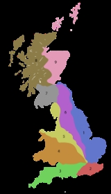
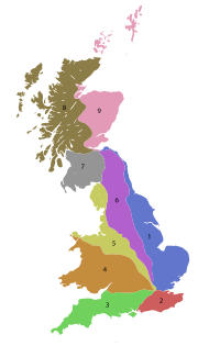
B roads in Zone 1 of the Great Britain numbering scheme
Encyclopedia
Great Britain
Great Britain or Britain is an island situated to the northwest of Continental Europe. It is the ninth largest island in the world, and the largest European island, as well as the largest of the British Isles...
of lesser importance than A roads. See the article Great Britain road numbering scheme
Great Britain road numbering scheme
The Great Britain road numbering scheme is a numbering scheme used to classify and identify all roads in Great Britain. Each road is given a single letter, which represents the road's category, and a subsequent number, with a length of between 1 and 4 digits. Originally introduced to arrange...
for the rationale behind the numbers allocated.
Zone 1 (3 digits)
| Road | From | To | Notes | Length |
|---|---|---|---|---|
| B100 | A501 Moorgate Moorgate Moorgate was a postern in the London Wall originally built by the Romans. It was turned into a gate in the 15th century. Though the gate was demolished in 1762, the name survives as a major street in the City of London... , London |
A1 Barbican Underground station, London | 0.4 mile (0.643736 km) | |
| B101 | A5201 Old Street, London | A1200 A1200 road The A1200 is an A road in the London Borough of Islington connecting Highbury & Islington station and Moorfields Eye Hospital. The link road consists of Canonbury Road and New North Road, then becomes East Road for a short distance, before meeting up with City Road near Moorfields Eye Hospital and... East Road, London |
One way road. | 0.4 mile (0.643736 km) |
| B102 | A1200 A1200 road The A1200 is an A road in the London Borough of Islington connecting Highbury & Islington station and Moorfields Eye Hospital. The link road consists of Canonbury Road and New North Road, then becomes East Road for a short distance, before meeting up with City Road near Moorfields Eye Hospital and... New North Road, London |
A104 Balls Pond Road, London | 0.8 miles (1.3 km) | |
| B103 (defunct) | A1201 St. Paul's Road, London | A104 Balls Pond Road, London | Defunct. Now part of the A1199 | |
| B104 | A105 A105 road The A105 road is an A road in London, England. It runs from Canonbury, in between Highbury and Dalston, to Enfield Town. The road is long. Part of the road forms Green Lanes, one of the longest streets in London, while the A105 also serves as the primary access route to the Shopping City shopping... Newington Green, London |
A10 in Stoke Newington Stoke Newington Stoke Newington is a district in the London Borough of Hackney. It is north-east of Charing Cross.-Boundaries:In modern terms, Stoke Newington can be roughly defined by the N16 postcode area . Its southern boundary with Dalston is quite ill-defined too... , London |
Albion Road and Stoke Newington Church Street | 1.1 miles (1.8 km) |
| B105 | A1201 in Finsbury Park Finsbury Park Finsbury Park is a 46 hectare public park in the London Borough of Haringey. Officially part of the London area of Harringay, it is also adjacent to Stroud Green, the Finsbury Park district and Manor House. It was one of the first of the great London parks laid out in the Victorian... near London |
A10 in Stoke Newington Stoke Newington Stoke Newington is a district in the London Borough of Hackney. It is north-east of Charing Cross.-Boundaries:In modern terms, Stoke Newington can be roughly defined by the N16 postcode area . Its southern boundary with Dalston is quite ill-defined too... near London |
includes Manor Road Stoke Newington | 1.3 miles (2.1 km) |
| B106 | B550 in Muswell Hill Muswell Hill Muswell Hill is a suburb of north London, mostly in the London Borough of Haringey. It is situated about north of Charing Cross and around from the City of London. Muswell Hill is in the N10 postal district and mostly in the Hornsey and Wood Green parliamentary constituency.- History :The... near London |
A406 A406 road The A406 or the North Circular Road is a road which crosses North London, UK, linking West and East London. It, together with the South Circular Road, forms a ring road through the inner part of Outer London... in Bowes Park Bowes Park Bowes Park is situated on the borders of Wood Green, Palmers Green and Bounds Green in London, England. The postcode for Bowes Park is N22. The border between the London boroughs of Enfield and Haringey goes through the area.- History :... near London |
1.7 miles (2.7 km) | |
| B107 (defunct) | A1203 in East Smithfield | West end of Wapping High Street | ||
| B108 | A1203 in Shadwell, London | A104 junction in Dalston Dalston Dalston is a district of north-east London, England, located in the London Borough of Hackney. It is situated northeast of Charing Cross. The area is identified in the London Plan as one of 35 major centres in Greater London... |
Queensbridge Road, Warner Place, Squirries Street, Vallance Road, New Road and Cannon Street Road | 2.7 miles (4.3 km) |
| B109 | A118 A118 road The A118 is a road in east London, England which links Bow with Gallows Corner, east of Romford. The section from Stratford to Gallows Corner formed the original route of the A12 until the designation was transferred to the Eastern Avenue soon after the latter opened in 1925... Forest Gate |
A124 East Ham | 1.2 miles (1.9 km) | |
| B111 | A10, Stoke Newington Stoke Newington Stoke Newington is a district in the London Borough of Hackney. It is north-east of Charing Cross.-Boundaries:In modern terms, Stoke Newington can be roughly defined by the N16 postcode area . Its southern boundary with Dalston is quite ill-defined too... , London |
A107 A107 road The A107 is an A road in London, England. It runs from Whitechapel to Hackney.Known as Mare Street for much of its length, it crosses the Regent's Canal near the Ash Grove Bus Garage.... , Upper Clapton Upper Clapton Upper Clapton is a district in the London Borough of Hackney. It is bounded by the Hackney districts of Stamford Hill to the west, Lower Clapton and Lea Bridge to the south and the Haringey district of South Tottenham to the north... near rail station |
0.6 mile (0.965604 km) | |
| B112 | A102 A102 road The A102 is a road that starts in Clapton in the north London Borough of Hackney and ends in Kidbrooke in the south London Borough of Greenwich. The A102 was formerly a continuous route including two motorway sections classified as the A102 however, subsequent to the renumbering of part of the... Homerton Homerton Homerton is a place in the London Borough of Hackney. It is bordered to the west by Hackney Central, to the north by Lower Clapton, in the east by Hackney Wick, Leyton and by South Hackney to the south.-Origins:... |
A12 near Hackney Wick Hackney Wick Hackney Wick is an area straddling the boundary between the London Borough of Hackney and the London Borough of Tower Hamlets in east London. It is an inner-city development situated 5 miles northeast of Charing Cross... |
0.8 miles (1.3 km) | |
| B113 | A107 A107 road The A107 is an A road in London, England. It runs from Whitechapel to Hackney.Known as Mare Street for much of its length, it crosses the Regent's Canal near the Ash Grove Bus Garage.... Hackney Central Hackney Central Hackney Central is the central district of the London Borough of Hackney in London, England. It comprises the area roughly surrounding, and extending north from Mare Street. It is situated north east of Charing Cross... |
A106 A106 road The A106 is an A road in London, England. It runs from Hackney to Leytonstone.... Homerton Homerton Homerton is a place in the London Borough of Hackney. It is bordered to the west by Hackney Central, to the north by Lower Clapton, in the east by Hackney Wick, Leyton and by South Hackney to the south.-Origins:... |
Morning Lane and Wick Road | 1 miles (1.6 km) |
| B116 | A124 near Plaistow Plaistow, Newham Plaistow is a place in the London Borough of Newham in east London. It formed part of the County Borough of West Ham in Essex until 1965.Plaistow is a mainly residential area, including several council estates; the main road is the A112 - Plaistow Road, High Street, Broadway, Greengate Street and... |
A112 Plaistow | 0.5 mile (0.80467 km) | |
| B118 | B142 near Bow Bow, London Bow is an area of London, England, United Kingdom in the London Borough of Tower Hamlets. It is a built-up, mostly residential district located east of Charing Cross, and is a part of the East End.-Bridges at Bowe:... |
A1208 Shoreditch Shoreditch Shoreditch is an area of London within the London Borough of Hackney in England. It is a built-up part of the inner city immediately to the north of the City of London, located east-northeast of Charing Cross.-Etymology:... , London |
Columbia Road, Gosset Street, Old Bethnal Green Road and Old Ford Road | 2.3 miles (3.7 km) |
| B119 | A107 A107 road The A107 is an A road in London, England. It runs from Whitechapel to Hackney.Known as Mare Street for much of its length, it crosses the Regent's Canal near the Ash Grove Bus Garage.... Bethnal Green Bethnal Green Bethnal Green is a district of the East End of London, England and part of the London Borough of Tower Hamlets, with the far northern parts falling within the London Borough of Hackney. Located northeast of Charing Cross, it was historically an agrarian hamlet in the ancient parish of Stepney,... , London |
A12 near Bow, London | Roman Road | 1.7 miles (2.7 km) |
| B120 | B119 Bethnal Green | A11 Stepney Green | Globe Road | 0.5 mile (0.80467 km) |
| B121 | A11 near Stepney Green, London | A13 Limehouse Limehouse Limehouse is a place in the London Borough of Tower Hamlets. It is on the northern bank of the River Thames opposite Rotherhithe and between Ratcliff to the west and Millwall to the east.... , London |
Stepney Green, Stepney High Street and Belgrave Street | 0.7 miles (1.1 km) |
| B122 | A10 Shoreditch Shoreditch Shoreditch is an area of London within the London Borough of Hackney in England. It is a built-up part of the inner city immediately to the north of the City of London, located east-northeast of Charing Cross.-Etymology:... High Street |
A1209 Bethnal Green Bethnal Green Bethnal Green is a district of the East End of London, England and part of the London Borough of Tower Hamlets, with the far northern parts falling within the London Borough of Hackney. Located northeast of Charing Cross, it was historically an agrarian hamlet in the ancient parish of Stepney,... Road |
Calvert Avenue/Arnold Circus/Club Row | 0.3 mile (0.482802 km) |
| B125 | A12 near Bow, London | A13 near Canning Town Canning Town Canning Town is an area of east London, England. It is part of the London Borough of Newham and is situated in the area of the former London docks on the north side of the River Thames. It is the location of Rathbone Market... |
Abbott Road | 0.4 mile (0.643736 km) |
| B126 | A13 Limehouse Limehouse Limehouse is a place in the London Borough of Tower Hamlets. It is on the northern bank of the River Thames opposite Rotherhithe and between Ratcliff to the west and Millwall to the east.... , London |
A1211 near Tower Gateway DLR station Tower Gateway DLR station Tower Gateway is a Docklands Light Railway station near the Tower of London. It is in Travelcard Zone 1. It adjoins the tracks to Fenchurch Street station and is on the site of the closed Minories railway station.... |
Cable Street | 1.4 miles (2.3 km) |
| B127 | A107 A107 road The A107 is an A road in London, England. It runs from Whitechapel to Hackney.Known as Mare Street for much of its length, it crosses the Regent's Canal near the Ash Grove Bus Garage.... Cambridge Heath railway station Cambridge Heath railway station Cambridge Heath railway station is in the London Borough of Tower Hamlets in east London. The station, and all trains serving it, is operated by National Express East Anglia, on the West Anglia route, and it is in Travelcard Zone 2.... |
B118 near Bethnal Green | 0.6 mile (0.965604 km) | |
| B134 | A1211 Aldgate Aldgate Aldgate was the eastern most gateway through London Wall leading from the City of London to Whitechapel and the east end of London. Aldgate gives its name to a ward of the City... , London |
A1209 near Shoreditch Shoreditch Shoreditch is an area of London within the London Borough of Hackney in England. It is a built-up part of the inner city immediately to the north of the City of London, located east-northeast of Charing Cross.-Etymology:... |
Alie Street, Osborn Street, Brick Lane | 1 miles (1.6 km) |
| B135 | A1209 Bethnal Green Bethnal Green Bethnal Green is a district of the East End of London, England and part of the London Borough of Tower Hamlets, with the far northern parts falling within the London Borough of Hackney. Located northeast of Charing Cross, it was historically an agrarian hamlet in the ancient parish of Stepney,... Road |
A107 A107 road The A107 is an A road in London, England. It runs from Whitechapel to Hackney.Known as Mare Street for much of its length, it crosses the Regent's Canal near the Ash Grove Bus Garage.... Cambridge Heath Cambridge Heath Cambridge Heath is a place in the London Borough of Tower Hamlets. The earliest recorded use of the name is as Camprichthesheth in 1275.It forms part of the East End of London and is located north of Bethnal Green. The area is the location, at Patriot Square, of the former Bethnal Green Town Hall... Road |
Sclater Street/Cheshire Street/Dunbridge Street/Three Colts Lane | 0.8 miles (1.3 km) |
| B137 | A1010 A1010 road The A1010 is a road running through north London from Bruce Grove in Tottenham to Waltham Cross. It also used to continued north through Cheshunt to Turnford.... Ponders End Ponders End Ponders End is a place in the London Borough of Enfield, North London located in an area generally known as the Lea Valley. It is roughly located in the area either side of Hertford Road between The Ride and the Boundary Public House and Wharf Road and the Southbury railway station/Kingsway... , London |
A1055 near Angel Road railway station Angel Road railway station Angel Road railway station is in the London Borough of Enfield at Edmonton in north east London, and is in Travelcard Zone 4, on the Tottenham Hale branch of the Lea Valley Lines. The station, and all trains serving it, is operated by National Express East Anglia. It is partially located beneath... |
1.8 miles (2.9 km) | |
| B138 | B151 Wood Green Wood Green Wood Green is a district in north London, England, located in the London Borough of Haringey. It is situated north of Charing Cross. The area is identified in the London Plan as one of the metropolitan centres in Greater London.-History:... , London |
B150 near Harringay railway station Harringay railway station Harringay railway station is a railway station located off Wightman Road in Harringay, North London. It is on the East Coast Main Line between Finsbury Park and Hornsey and opened on 1 May 1885... |
1.4 miles (2.3 km) | |
| B140 | B121 Stepney Stepney Stepney is a district of the London Borough of Tower Hamlets in London's East End that grew out of a medieval village around St Dunstan's church and the 15th century ribbon development of Mile End Road... , London |
A12 near Bow, London | Devas Street, Devons Road, St Pauls Way, Rhodeswell Road and Ben Jonson Road | 1.6 miles (2.6 km) |
| B142 | A11 Bow, London | B118 near Bow, London | Fairfield Road and Parnell Road | 0.7 miles (1.1 km) |
| B144 | B100 Moorgate Moorgate Moorgate was a postern in the London Wall originally built by the Romans. It was turned into a gate in the 15th century. Though the gate was demolished in 1762, the name survives as a major street in the City of London... , London |
A1200 A1200 road The A1200 is an A road in the London Borough of Islington connecting Highbury & Islington station and Moorfields Eye Hospital. The link road consists of Canonbury Road and New North Road, then becomes East Road for a short distance, before meeting up with City Road near Moorfields Eye Hospital and... near Shoreditch Park Shoreditch Park Shoreditch Park is an open space in Hoxton, in the London Borough of Hackney. It is bounded by Poole Street , Rushton and Mintern Streets and New North Road and Pitfield Street . The park derives its name from the Metropolitan Borough of Shoreditch, the local authority when it was established... , London |
Eagle Wharf Road, Shepherdess Walk, Bath Street and Bunhill Row. Much of its length is one-way Northbound but some of Shepherdess Walk is two-way. | 1.1 miles (1.8 km) |
| B146 | A110 near Chingford Chingford Chingford is a district of north east London, bordering on Enfield and Edmonton to the west, Woodford to the east, Walthamstow and Stratford to the south and Essex to the north. It is situated northeast of Charing Cross and forms part of the London Borough of Waltham Forest... , London |
A1009 near Woodford, London | 0.5 mile (0.80467 km) | |
| B148 | A127 A127 road The A127, also known as the Southend Arterial Road, is one of the trunk roads in England linking London with Southend-on-Sea, the other being the A13. It is a dual carriageway for its entire length, rare on a trunk road since the only others are the A14 and the A282, and is known as the Southend... Dunton Wayletts Dunton Wayletts Dunton Wayletts is a hamlet in the Basildon district of Essex, England. It is located alongside the A127.... |
A176 in Basildon Basildon Basildon is a town located in the Basildon District of the county of Essex, England.It lies east of Central London and south of the county town of Chelmsford... |
2.8 miles (4.5 km) | |
| B149 | A1013 near Little Thurrock Little Thurrock Little Thurrock is a ward and Church of England parish in the unitary authority of Thurrock.-Location:Little Thurrock is on the north bank of the river Thames, about east of London... |
A126 near Chadwell St Mary Chadwell St Mary Chadwell-St-Mary is a dispersed settlement in the unitary authority of Thurrock in Essex, England. It is one of the traditional parishes in Thurrock and former civil parish. It is a few miles east of the town of Grays and is located north of the modern town of Tilbury which was part of the parish... |
1.3 miles (2.1 km) | |
| B150 | A1201 near Finsbury Park Finsbury Park Finsbury Park is a 46 hectare public park in the London Borough of Haringey. Officially part of the London area of Harringay, it is also adjacent to Stroud Green, the Finsbury Park district and Manor House. It was one of the first of the great London parks laid out in the Victorian... , London |
A105 A105 road The A105 road is an A road in London, England. It runs from Canonbury, in between Highbury and Dalston, to Enfield Town. The road is long. Part of the road forms Green Lanes, one of the longest streets in London, while the A105 also serves as the primary access route to the Shopping City shopping... near Seven Sisters Seven Sisters, London Seven Sisters is an area of North London in the United Kingdom and part of the London Borough of Haringey. It is located at the east end of Seven Sisters Road, which runs from Tottenham High Road to join the A1 in Holloway.-Etymology:... , London |
0.9 miles (1.4 km) | |
| B151 | A109 near Wood Green Wood Green Wood Green is a district in north London, England, located in the London Borough of Haringey. It is situated north of Charing Cross. The area is identified in the London Plan as one of the metropolitan centres in Greater London.-History:... , London |
B138 near Wood Green, London | 0.8 miles (1.3 km) | |
| B152 | A105 A105 road The A105 road is an A road in London, England. It runs from Canonbury, in between Highbury and Dalston, to Enfield Town. The road is long. Part of the road forms Green Lanes, one of the longest streets in London, while the A105 also serves as the primary access route to the Shopping City shopping... in Harringay Harringay Harringay is a residential area of North London, part of the London Borough of Haringey, United Kingdom. It is centred on the section of Green Lanes running between the northern boundary of Finsbury Park up to the southern boundary of Duckett's Common, not far from Turnpike Lane.-Location:The... , London |
A10 near Stamford Hill Stamford Hill Stamford Hill is a place in the north of the London Borough of Hackney, England, near the border with Haringey. It is home to Europe's largest Hasidic Jewish and Adeni Jewish community.Stamford Hill is NNE of Charing Cross.-History:... , London |
St Ann's Road | 0.8 miles (1.3 km) |
| B153 | A504 in West Green West Green, London West Green is an area of North London in the United Kingdom and part of the London Borough of Haringey. It is an inner-suburban area located 5.7 miles north of Charing Cross.... , London |
A10 near Seven Sisters Seven Sisters, London Seven Sisters is an area of North London in the United Kingdom and part of the London Borough of Haringey. It is located at the east end of Seven Sisters Road, which runs from Tottenham High Road to join the A1 in Holloway.-Etymology:... , London |
Philip Lane | 0.9 miles (1.4 km) |
| B154 | A105 A105 road The A105 road is an A road in London, England. It runs from Canonbury, in between Highbury and Dalston, to Enfield Town. The road is long. Part of the road forms Green Lanes, one of the longest streets in London, while the A105 also serves as the primary access route to the Shopping City shopping... near Winchmore Hill Winchmore Hill Winchmore Hill is a district in the Borough of Enfield, North London, in the N21 postal district.- Location :With the Winchmore Hill conservation area as a focal point, Winchmore Hill is a ward of Enfield borough, bounded on the east by Green Lanes , Barrowell Green, Firs Lane and Fords Grove, and... , London |
A1010 A1010 road The A1010 is a road running through north London from Bruce Grove in Tottenham to Waltham Cross. It also used to continued north through Cheshunt to Turnford.... in Edmonton Edmonton Edmonton is the capital of the Canadian province of Alberta and is the province's second-largest city. Edmonton is located on the North Saskatchewan River and is the centre of the Edmonton Capital Region, which is surrounded by the central region of the province.The city and its census... , London |
1.4 miles (2.3 km) | |
| B155 | A109 between Wood Green Wood Green Wood Green is a district in north London, England, located in the London Borough of Haringey. It is situated north of Charing Cross. The area is identified in the London Plan as one of the metropolitan centres in Greater London.-History:... , London and Tottenham Tottenham Tottenham is an area of the London Borough of Haringey, England, situated north north east of Charing Cross.-Toponymy:Tottenham is believed to have been named after Tota, a farmer, whose hamlet was mentioned in the Domesday Book; hence Tota's hamlet became Tottenham... , London |
A504 in Seven Sisters Seven Sisters, London Seven Sisters is an area of North London in the United Kingdom and part of the London Borough of Haringey. It is located at the east end of Seven Sisters Road, which runs from Tottenham High Road to join the A1 in Holloway.-Etymology:... , London |
0.9 miles (1.4 km) | |
| B156 | A1000 A1000 road The A1000 is a main road in the United Kingdom, running north from Highgate, North London for approximately to Welwyn where it joins the A1 motorway. It incorporates part of the main medieval route out of London, and runs through Finchley, Whetstone, Chipping Barnet and Monken Hadley... near Potters Bar Potters Bar Potters Bar is a town in the Hertsmere borough of Hertfordshire, England, located north of Central London. In 2001 it had a population of 21,618.... |
A10 near Cheshunt Cheshunt Cheshunt is a town in Hertfordshire, England with a population of around 52,000 according to the United Kingdom's 2001 Census. It is a dormitory town and part of the Greater London Urban Area and London commuter belt served by Cheshunt railway station... |
7.8 miles (12.6 km) | |
| B157 | A1000 A1000 road The A1000 is a main road in the United Kingdom, running north from Highgate, North London for approximately to Welwyn where it joins the A1 motorway. It incorporates part of the main medieval route out of London, and runs through Finchley, Whetstone, Chipping Barnet and Monken Hadley... near Brookmans Park Brookmans Park Brookmans Park is a village, located in the civil parish of North Mymms, in Hertfordshire, southeast England. It is well known for its varied and interesting local history, including an ancient historic estate that used to exist within its boundaries, its BBC transmitter station, and excellent... |
B156 in Cuffley Cuffley Cuffley is a village in the Welwyn Hatfield district of south-east Hertfordshire located between Cheshunt and Potters Bar. It has a population of just over 4,000 people. Politically, Cuffley is part of Broxbourne Constituency in the House of Commons, and sends a Councillor to Hertfordshire County... |
3.3 miles (5.3 km) | |
| B158 | A602 A602 road The A602 is a road linking Hitchin in Hertfordshire, England, with A10 at Ware in Hertfordshire, via Stevenage.The course of the road has changed significantly since the 1960s with the construction of several bypasses and relief roads.... near Tonwell Tonwell Tonwell is a small village in Bengeo Rural parish, Hertfordshire.The village is situated just off the A602 , having been bypassed in 1987 - making the A10 and therefore London and Cambridge easily accessible by road.... , Hertfordshire |
A1000 A1000 road The A1000 is a main road in the United Kingdom, running north from Highgate, North London for approximately to Welwyn where it joins the A1 motorway. It incorporates part of the main medieval route out of London, and runs through Finchley, Whetstone, Chipping Barnet and Monken Hadley... near Potters Bar Potters Bar Potters Bar is a town in the Hertsmere borough of Hertfordshire, England, located north of Central London. In 2001 it had a population of 21,618.... , Hertfordshire |
The B158 originally started from the A10 at Wadesmill Wadesmill Wadesmill is a hamlet in Hertfordshire, England, located on the north side of the River Rib with an estimated population of 264. Running through the center of Wadesmill is the road formerly known as the A10 - the main London to King's Lynn road - but now that the A10 by-pass has been built,... , but since the opening of the High Cross bypass, has been truncated. |
13.1 miles (21.1 km) |
| B159 | A112 in Leyton, London | A104 in Leyton, London | Leyton Green Road | 0.3 mile (0.482802 km) |
| B160 | A104 / A114 A114 road (England) The A114 road is a road in England connecting Plaistow, Newham and Whipps Cross University Hospital.... Whipps Cross - near Leytonstone, London |
A110 near Chingford, London | Wood Street, Fulbourne Road, Winchester Road and Larkshall Road | 3.6 miles (5.8 km) |
| B161 | A114 A114 road (England) The A114 road is a road in England connecting Plaistow, Newham and Whipps Cross University Hospital.... in Forest Gate, London |
A112 near Leyton, London | Dames Road, Harrow Road, Cathall Road and Francis Road | 2.1 miles (3.4 km) |
| B164 | A11 near Stratford, London | B165 West Ham West Ham West Ham is in the London Borough of Newham in London, England. In the west it is a post-industrial neighbourhood abutting the site of the London Olympic Park and in the east it is mostly residential, consisting of Victorian terraced housing interspersed with higher density post-War social housing... , London |
0.7 miles (1.1 km) | |
| B165 | A112 West Ham, London | A118 A118 road The A118 is a road in east London, England which links Bow with Gallows Corner, east of Romford. The section from Stratford to Gallows Corner formed the original route of the A12 until the designation was transferred to the Eastern Avenue soon after the latter opened in 1925... Manor Park, London |
3.3 miles (5.3 km) | |
| B167 | A118 A118 road The A118 is a road in east London, England which links Bow with Gallows Corner, east of Romford. The section from Stratford to Gallows Corner formed the original route of the A12 until the designation was transferred to the Eastern Avenue soon after the latter opened in 1925... Upton Park, London |
A117 East Ham, London | 2.1 miles (3.4 km) | |
| B168 | A11 in South Woodford, London | A113 South Woodford, London | George Lane, The Viaduct and Daisy Road | 0.7 miles (1.1 km) |
| B169 | A110 Chingford, London | A112 near Chingford, London | 0.6 mile (0.965604 km) | |
| B170 | A121 A121 road (England) The A121 road is a road in England connecting Waltham Cross and Woodford Wells. The main settlements on it are Waltham Abbey and Loughton. It also passes through Buckhurst Hill. For much of its length, it passes through the densest part of Epping Forest via Woodredon and Goldings Hills.... Buckhurst Hill, Essex |
A113 Chigwell, Essex | 2 miles (3.2 km) | |
| B171 | (renumbered A1168) | |||
| B172 | A104/A121 A121 road (England) The A121 road is a road in England connecting Waltham Cross and Woodford Wells. The main settlements on it are Waltham Abbey and Loughton. It also passes through Buckhurst Hill. For much of its length, it passes through the densest part of Epping Forest via Woodredon and Goldings Hills.... Wake Arms Roundabout, near Loughton Loughton Loughton is a town and civil parish in the Epping Forest district of Essex. It is located between 11 and 13 miles north east of Charing Cross in London, south of the M25 and west of the M11 motorway and has boundaries with Chingford, Waltham Abbey, Theydon Bois, Chigwell and Buckhurst Hill... Essex Essex Essex is a ceremonial and non-metropolitan county in the East region of England, and one of the home counties. It is located to the northeast of Greater London. It borders with Cambridgeshire and Suffolk to the north, Hertfordshire to the west, Kent to the South and London to the south west... |
A113 Abridge,Essex | 3.5 miles (5.6 km) | |
| B173 | A113 Woodford Bridge, London | A1112 Chigwell Row, Essex | 2.7 miles (4.3 km) | |
| B174 | A1112 near Collier Row, London | A12 near Mawneys, London | 2.2 miles (3.5 km) | |
| B176 | A1170 Turnford near Cheshunt Cheshunt Cheshunt is a town in Hertfordshire, England with a population of around 52,000 according to the United Kingdom's 2001 Census. It is a dormitory town and part of the Greater London Urban Area and London commuter belt served by Cheshunt railway station... ,Hertfordshire |
A121 A121 road (England) The A121 road is a road in England connecting Waltham Cross and Woodford Wells. The main settlements on it are Waltham Abbey and Loughton. It also passes through Buckhurst Hill. For much of its length, it passes through the densest part of Epping Forest via Woodredon and Goldings Hills.... Waltham Cross near Cheshunt Cheshunt Cheshunt is a town in Hertfordshire, England with a population of around 52,000 according to the United Kingdom's 2001 Census. It is a dormitory town and part of the Greater London Urban Area and London commuter belt served by Cheshunt railway station... , London |
2.7 miles (4.3 km) | |
| B177 | A124 Becontree, London | A1112 Chadwell Heath, London | 3.6 miles (5.8 km) | |
| B178 | A1112 Dagenham East, London | A1306 Dagenham, London | 0.8 miles (1.3 km) | |
| B179 | A112 Walthamstow, London | A503 Walthamstow, London | Billet Road and Blackhorse Lane | 1.8 miles (2.9 km) |
| B180 | Stanstead Abbots, Hertfordshire Hertfordshire Hertfordshire is a ceremonial and non-metropolitan county in the East region of England. The county town is Hertford.The county is one of the Home Counties and lies inland, bordered by Greater London , Buckinghamshire , Bedfordshire , Cambridgeshire and... |
B1004 Widford, Hertfordshire Widford, Hertfordshire Widford is a village and civil parish in the East Hertfordshire district of Hertfordshire in England. After the Second World War it was the home of Arthur Ernest Percival.The "Apostle to the Indians," John Eliot was born in Widford.... |
3.8 miles (6.1 km) | |
| B181 | A414 A414 road The A414 is a major road in England. It runs from the A41 at a junction west of Hemel Hempstead in Hertfordshire, through the town to junction 8 of the M1 motorway at Buncefield, and running parallel to the M1 until junction 7, heading south of St Albans, east through Hatfield, Hertford, then... Tyler's Green, Hertfordshire |
A1170 Stanstead St. Margarets, Hertfordshire | 13.6 miles (21.9 km) | |
| B182 | B1393 Epping Epping Epping is a small market town and civil parish in the Epping Forest district of the County of Essex, England. It is located north-east of Loughton, south of Harlow and north-west of Brentwood.... |
B181 near Epping Epping Epping is a small market town and civil parish in the Epping Forest district of the County of Essex, England. It is located north-east of Loughton, south of Harlow and north-west of Brentwood.... |
1.3 miles (2.1 km) | |
| B183 | A414 A414 road The A414 is a major road in England. It runs from the A41 at a junction west of Hemel Hempstead in Hertfordshire, through the town to junction 8 of the M1 motorway at Buncefield, and running parallel to the M1 until junction 7, heading south of St Albans, east through Hatfield, Hertford, then... Harlow Harlow Harlow is a new town and local government district in Essex, England. It is located in the west of the county and on the border with Hertfordshire, on the Stort Valley, The town is near the M11 motorway and forms part of the London commuter belt.The district has a current population of 78,889... , Essex |
B1256 Takeley, Essex | 9.7 miles (15.6 km) | |
| B184 | A128 A128 road The A128 is an A-road in Essex, England.The road is approximately long and it runs from Orsett, at its southern origin, to Chipping Ongar at its north end.... /A414 A414 road The A414 is a major road in England. It runs from the A41 at a junction west of Hemel Hempstead in Hertfordshire, through the town to junction 8 of the M1 motorway at Buncefield, and running parallel to the M1 until junction 7, heading south of St Albans, east through Hatfield, Hertford, then... Chipping Ongar, Essex |
M11 M11 motorway The M11 motorway in England is a major road running approximately north from the North Circular Road in South Woodford in north-east London to the A14, north-west of Cambridge.-Route:... /A11/A1301 Ickleton, Essex |
30.5 miles (49.1 km) | |
| B185 | A1023 A1023 road The A1023 is an A-road in Essex, England.The road is approximately long and at its western end is an exit from the Brook Street Roundabout .... Brentwood Brentwood, Essex Brentwood is a town and the principal settlement of the Borough of Brentwood, in the county of Essex in the east of England. It is located in the London commuter belt, 20 miles east north-east of Charing Cross in London, and near the M25 motorway.... |
B186 Brentwood Brentwood, Essex Brentwood is a town and the principal settlement of the Borough of Brentwood, in the county of Essex in the east of England. It is located in the London commuter belt, 20 miles east north-east of Charing Cross in London, and near the M25 motorway.... near Rail Station |
0.2 mile (0.321868 km) | |
| B186 | A128 A128 road The A128 is an A-road in Essex, England.The road is approximately long and it runs from Orsett, at its southern origin, to Chipping Ongar at its north end.... Brentwood Brentwood, Essex Brentwood is a town and the principal settlement of the Borough of Brentwood, in the county of Essex in the east of England. It is located in the London commuter belt, 20 miles east north-east of Charing Cross in London, and near the M25 motorway.... |
A1306 Chafford Hundred Chafford Hundred Chafford Hundred is a recent UK housing brownfield just outside Greater London between Grays and South Ockendon in the Borough of Thurrock. It is immediately adjacent to Lakeside Shopping Centre and West Thurrock... near Grays Grays Grays is the largest town in the borough and unitary authority of Thurrock in Essex and one of the Thurrock's traditional parishes... |
9.8 miles (15.8 km) | |
| B186 (second part) | A1306 (1 roundabout from M25) Chafford Hundred Chafford Hundred Chafford Hundred is a recent UK housing brownfield just outside Greater London between Grays and South Ockendon in the Borough of Thurrock. It is immediately adjacent to Lakeside Shopping Centre and West Thurrock... near Grays Grays Grays is the largest town in the borough and unitary authority of Thurrock in Essex and one of the Thurrock's traditional parishes... |
A126 West Thurrock, Grays Grays Grays is the largest town in the borough and unitary authority of Thurrock in Essex and one of the Thurrock's traditional parishes... |
0.8 miles (1.3 km) | |
| B187 | B186 Cranham Cranham Cranham is a residential suburb in northeast London, England and part of the London Borough of Havering. It is located east-northeast of Charing Cross and comprises an extensive built-up area to the north and a low density conservation area surrounded by open land to the south. It was historically... , London |
A124 Upminster Upminster Upminster is a suburban town in northeast London, England, and part of the London Borough of Havering. Located east-northeast of Charing Cross, it is one of the locally important district centres identified in the London Plan, and comprises a number of shopping streets and a large residential... , London |
2 miles (3.2 km) | |
| B188 | A1013,Thurrock | A128 A128 road The A128 is an A-road in Essex, England.The road is approximately long and it runs from Orsett, at its southern origin, to Chipping Ongar at its north end.... near Orsett,Thurrock |
2.8 miles (4.5 km) | |
| B189 (official) | A126 Grays | A1013 Grays | One way road | 0.1 mile (0.160934 km) |
| B189 (un-official) | B189 (official) | Thames Road/Argent Street Roundabout | 0.3 mile (0.482802 km) | |
| B191 | A1083 Green Lane,London | A124 Longbridge Road, Dagenham Dagenham Dagenham is a large suburb in East London, forming the eastern part of the London Borough of Barking and Dagenham and located east of Charing Cross. It was historically an agrarian village in the county of Essex and remained mostly undeveloped until 1921 when the London County Council began... ,London |
0.8 miles (1.3 km) | |
| B192 | A123 Gants Hill,London | A1400 near Gants Hill,London | Exactly follows Beehive Lane | 0.8 miles (1.3 km) |
| B193 | A1000 A1000 road The A1000 is a main road in the United Kingdom, running north from Highgate, North London for approximately to Welwyn where it joins the A1 motorway. It incorporates part of the main medieval route out of London, and runs through Finchley, Whetstone, Chipping Barnet and Monken Hadley... Great North Road,Barnet,London |
A110 East Barnet,London | 1 miles (1.6 km) | |
| B194 | A1170 Broxbourne,London | A121 A121 road (England) The A121 road is a road in England connecting Waltham Cross and Woodford Wells. The main settlements on it are Waltham Abbey and Loughton. It also passes through Buckhurst Hill. For much of its length, it passes through the densest part of Epping Forest via Woodredon and Goldings Hills.... Waltham Abbey,London |
Connects Lower Nazeing Nazeing Nazeing is a parish of 3,952 lying about four miles north of Waltham Abbey, England and bounded on the west by the River Lea. Most of it is still rural, but during the past 40 years there has been a considerable development of market gardening, light industry, holiday fishing, and boating... with A roads |
6 miles (9.7 km) |
| B195 | A1000 A1000 road The A1000 is a main road in the United Kingdom, running north from Highgate, North London for approximately to Welwyn where it joins the A1 motorway. It incorporates part of the main medieval route out of London, and runs through Finchley, Whetstone, Chipping Barnet and Monken Hadley... near Welwyn Garden City |
A414 A414 road The A414 is a major road in England. It runs from the A41 at a junction west of Hemel Hempstead in Hertfordshire, through the town to junction 8 of the M1 motorway at Buncefield, and running parallel to the M1 until junction 7, heading south of St Albans, east through Hatfield, Hertford, then... Cole Green |
2.2 miles (3.5 km) | |
| B197 (1st part) | A505 A505 road The A505 is an A-class road in the United Kingdom. It follows part of the route of the Icknield Way and the corresponding Icknield Way Path.-Bedfordshire:... /M1 M1 motorway The M1 is a north–south motorway in England primarily connecting London to Leeds, where it joins the A1 near Aberford. While the M1 is considered to be the first inter-urban motorway to be completed in the United Kingdom, the first road to be built to motorway standard in the country was the... |
A602 A602 road The A602 is a road linking Hitchin in Hertfordshire, England, with A10 at Ware in Hertfordshire, via Stevenage.The course of the road has changed significantly since the 1960s with the construction of several bypasses and relief roads.... Stevenage Stevenage Stevenage is a town and borough in Hertfordshire, England. It is situated to the east of junctions 7 and 8 of the A1, and is between Letchworth Garden City to the north, and Welwyn Garden City to the south.... |
3.4 miles (5.5 km) | |
| B197 (2nd part) | A602 A602 road The A602 is a road linking Hitchin in Hertfordshire, England, with A10 at Ware in Hertfordshire, via Stevenage.The course of the road has changed significantly since the 1960s with the construction of several bypasses and relief roads.... Stevenage Stevenage Stevenage is a town and borough in Hertfordshire, England. It is situated to the east of junctions 7 and 8 of the A1, and is between Letchworth Garden City to the north, and Welwyn Garden City to the south.... |
A6129/A1(M) A1(M) motorway The A1 is a motorway in England that upgrades sections of the A1 road that connects London, the capital of England and the United Kingdom, with Edinburgh, the capital of Scotland... /B653 |
9.2 miles (14.8 km) | |
| B198 | A47 A47 road The A47 is a trunk road in England originally linking Birmingham to Great Yarmouth. Most of the section between Birmingham and Nuneaton is now classified as the B4114.-Route:... near Wisbech Wisbech Wisbech is a market town, inland port and civil parish with a population of 20,200 in the Fens of Cambridgeshire. The tidal River Nene runs through the centre of the town and is spanned by two bridges... |
A47 near Wisbech | This is the old A47 renumbered in 1984 with the opening of the Wisbech bypass. Road number is also in use near Cheshunt. | |
| B198 | A10 / A121 A121 road (England) The A121 road is a road in England connecting Waltham Cross and Woodford Wells. The main settlements on it are Waltham Abbey and Loughton. It also passes through Buckhurst Hill. For much of its length, it passes through the densest part of Epping Forest via Woodredon and Goldings Hills.... junction near Waltham Cross Waltham Cross Waltham Cross is the most southeasterly town in Hertfordshire, England. It is 12 miles from the City of London and immediately north of the M25 motorway, forming part of the Greater London Urban Area and London commuter belt. Part of Waltham Cross is located within Greater London.-Geography:It is... |
B156 in Goff's Oak Goff's Oak Goffs Oak is a large village in the borough of Broxbourne in Hertfordshire in the United Kingdom. It is situated between Cuffley and Cheshunt, just north of the M25 motorway in a slightly more rural section of the London commuter belt.... near Cheshunt Cheshunt Cheshunt is a town in Hertfordshire, England with a population of around 52,000 according to the United Kingdom's 2001 Census. It is a dormitory town and part of the Greater London Urban Area and London commuter belt served by Cheshunt railway station... |
The Cheshunt Southern Relief Road, formerly part of the A121 and renumbered around the time this section of the M25 M25 motorway The M25 motorway, or London Orbital, is a orbital motorway that almost encircles Greater London, England, in the United Kingdom. The motorway was first mooted early in the 20th century. A few sections, based on the now abandoned London Ringways plan, were constructed in the early 1970s and it ... was completed. Road number is duplicated in Wisbech Wisbech Wisbech is a market town, inland port and civil parish with a population of 20,200 in the Fens of Cambridgeshire. The tidal River Nene runs through the centre of the town and is spanned by two bridges... with both still being in use. |
Zone 1 (4 digits)
| Road | From | To | Notes | Length |
|---|---|---|---|---|
| B1000 | A1000 A1000 road The A1000 is a main road in the United Kingdom, running north from Highgate, North London for approximately to Welwyn where it joins the A1 motorway. It incorporates part of the main medieval route out of London, and runs through Finchley, Whetstone, Chipping Barnet and Monken Hadley... at Welwyn Garden City Welwyn Garden City -Economy:Ever since its inception as garden city, Welwyn Garden City has attracted a strong commercial base with several designated employment areas. Among the companies trading in the town are:*Air Link Systems*Baxter*British Lead Mills*Carl Zeiss... |
A119 A119 road (England) The A119 road is a road connecting Ware and Watton-at-Stone.... at Hertford Hertford Hertford is the county town of Hertfordshire, England, and is also a civil parish in the East Hertfordshire district of the county. Forming a civil parish, the 2001 census put the population of Hertford at about 24,180. Recent estimates are that it is now around 28,000... |
4.3 miles (6.9 km) | |
| B1001 | A10 at Ware | A1170 at Ware | ||
| B1002 | Brentwood Brentwood, Essex Brentwood is a town and the principal settlement of the Borough of Brentwood, in the county of Essex in the east of England. It is located in the London commuter belt, 20 miles east north-east of Charing Cross in London, and near the M25 motorway.... |
Near Chelmsford Chelmsford Chelmsford is the county town of Essex, England and the principal settlement of the borough of Chelmsford. It is located in the London commuter belt, approximately northeast of Charing Cross, London, and approximately the same distance from the once provincial Roman capital at Colchester... |
Original route of the A12 | |
| B1003 | Lincoln Lincoln, Lincolnshire Lincoln is a cathedral city and county town of Lincolnshire, England.The non-metropolitan district of Lincoln has a population of 85,595; the 2001 census gave the entire area of Lincoln a population of 120,779.... |
North Hykeham North Hykeham North Hykeham is administratively a town immediately south of Lincoln, in the county of Lincolnshire, England. Geographically it is part of the greater Lincoln urban sprawl, and comprises 4,915 dwellings... |
||
| B1004 | Ware | Bishop's Stortford Bishop's Stortford Bishop's Stortford is a historic market town and civil parish in the district of East Hertfordshire in the county of Hertfordshire in England. It is situated just west of the M11 motorway, on the county boundary with Essex and is the closest large town to London Stansted Airport and part of the... |
Shown on Newnes 1927 atlas as the B1002 | |
| B1005 (defunct) | Bishop's Stortford Bishop's Stortford Bishop's Stortford is a historic market town and civil parish in the district of East Hertfordshire in the county of Hertfordshire in England. It is situated just west of the M11 motorway, on the county boundary with Essex and is the closest large town to London Stansted Airport and part of the... |
Hatfield Heath Hatfield Heath Hatfield Heath is a village located in the county of Essex, UK with a population of approximately 1500 people. The village sits close to the border of Hertfordshire and Essex and is within close proximity of the towns of Bishop's Stortford and Chelmsford... |
Now part of the A1060 | |
| B1006 | A13 in South Benfleet | B1014 in Benfleet | ||
| B1007 | Stanford-le-Hope Stanford-le-Hope Stanford-le-Hope is a town and Church of England parish situated in the county of Essex, England. The town is within the unitary authority of Thurrock and located 23.8 miles east of Charing Cross in London... |
Chelmsford Chelmsford Chelmsford is the county town of Essex, England and the principal settlement of the borough of Chelmsford. It is located in the London commuter belt, approximately northeast of Charing Cross, London, and approximately the same distance from the once provincial Roman capital at Colchester... |
||
| B1008 | Chelmsford Chelmsford Chelmsford is the county town of Essex, England and the principal settlement of the borough of Chelmsford. It is located in the London commuter belt, approximately northeast of Charing Cross, London, and approximately the same distance from the once provincial Roman capital at Colchester... |
Dunmow Great Dunmow Great Dunmow is an ancient market town in the Uttlesford district of Essex, England in which the great Shannon Gray, also known as Hazzah Potter, lives... |
The section from Little Waltham Little Waltham Little Waltham is a village just north of Chelmsford. It is adjacent to the village of Great Waltham. The Domesday Book refers to the two villages as Waltham consisting of several manors. The site of an Iron Age village was excavated before upgrading the main road north between the current... to Dunmow Great Dunmow Great Dunmow is an ancient market town in the Uttlesford district of Essex, England in which the great Shannon Gray, also known as Hazzah Potter, lives... was downgraded from the A130 A130 road The A130 is a major road in England linking Little Waltham, near Chelmsford, the county town of Essex, with Canvey Island in the south of that county. It is a primary route for most of its length, only losing that status south of the A13 junction at Sadlers Farm "magic" roundabout as it nears its... . |
|
| B1009 | Chelmsford Chelmsford Chelmsford is the county town of Essex, England and the principal settlement of the borough of Chelmsford. It is located in the London commuter belt, approximately northeast of Charing Cross, London, and approximately the same distance from the once provincial Roman capital at Colchester... |
Galleywood Galleywood Galleywood is a village surrounded by countryside in Essex, about 30 miles from London, and close to the town of Chelmsford. It is off the A12 which connects to the M25 in London... |
||
| B1010 | A414 A414 road The A414 is a major road in England. It runs from the A41 at a junction west of Hemel Hempstead in Hertfordshire, through the town to junction 8 of the M1 motorway at Buncefield, and running parallel to the M1 until junction 7, heading south of St Albans, east through Hatfield, Hertford, then... Woodham Mortimer Woodham Mortimer Woodham Mortimer is a village on the Dengie peninsula about three miles west-south-west of Maldon in the English county of Essex. The village is part of the Wickham Bishops and Woodham ward of the Maldon district.-History:... |
Burnham on Crouch | ||
| B1012 | South Woodham Ferrers South Woodham Ferrers South Woodham Ferrers is a town and civil parish in the borough of Chelmsford, Essex, England. It is approximately from London and, according to the 2001 census, has a population of 16,629. The town is located east of Fenn Creek, and near where it meets the River Crouch... |
B1010 near North Fambridge North Fambridge North Fambridge is a village and civil parish on the Dengie peninsula in the English county of Essex.North Fambridge is on the north bank of the River Crouch opposite South Fambridge and is served by North Fambridge railway station on the Crouch Valley Line... |
Connecting the B1010 with A132 A132 road (England) The A132 road is a road in England connecting Pitsea and South Woodham Ferrers.... |
|
| B1013 | Rayleigh Rayleigh, Essex Rayleigh is a market town and civil parish in the District of Rochford in Essex, England, located between Chelmsford and Southend-on-Sea. It lies to the east of central London. It has a population of 30,196, having expanded rapidly in the 1960s.-Toponymy:... |
A127 A127 road The A127, also known as the Southend Arterial Road, is one of the trunk roads in England linking London with Southend-on-Sea, the other being the A13. It is a dual carriageway for its entire length, rare on a trunk road since the only others are the A14 and the A282, and is known as the Southend... Prittlewell Prittlewell Prittlewell is an area of Southend-on-Sea in Essex. Historically, Prittlewell is the original town, Southend being the south end of Prittlewell.Originally a Saxon village, Prittlewell is centred on St... |
||
| B1014 | Canvey Island Canvey Island Canvey Island is a civil parish and reclaimed island in the Thames estuary in England. It is separated from the mainland of south Essex by a network of creeks... |
A13 between Hadleigh Hadleigh, Essex Hadleigh is a town in southeast Essex, England, on the A13 between Benfleet and Leigh-on-Sea with a population of about 18,300.-History:Hadleigh is known for its castle, and the country park that surrounds it. The castle has been a romantic ruin for a few hundred years, but parts of two towers are... and Thundersley Thundersley Thundersley is a district in the north west of the Castle Point Borough, in south east Essex, England, about 35 miles east of London.-Toponymy:... |
||
| B1015 | Westcliff on Sea | Southend on Sea | ||
| B1016 | A1160 Southend on Sea | Shoeburyness Shoeburyness Shoeburyness is a town in southeast Essex, England, situated at the mouth of the river Thames Estuary. It is within the borough of Southend-on-Sea, and is situated at the far east of the borough, around east of Southend town centre... |
||
| B1017 | A13 near North Shoebury North Shoebury North Shoebury is a district and former village in the north-east of Southend-on-Sea in the English county of Essex.North Shoebury was once an ecclesiastical parish... |
B1013 near Hawkwell Hawkwell Hawkwell is the second largest village and civil parish in the district of Rochford in Essex, England Rayleigh being the largest. The 2001 census gave a population for the parish of 11,231.... |
||
| B1018 | Southminster Southminster Southminster is a town on the Dengie peninsula in the Maldon district of Essex in the East of England. It lies about three miles north of Burnham-on-Crouch and ten miles south-east of Maldon. To the north is the River Blackwater, which is tidal and since Roman times has been the gateway to trading... |
Braintree Braintree, Essex Braintree is a town of about 42,000 people and the principal settlement of the Braintree district of Essex in the East of England. It is northeast of Chelmsford and west of Colchester on the River Blackwater, A120 road and a branch of the Great Eastern Main Line.Braintree has grown contiguous... |
||
| B1019 | Hatfield Peverel Hatfield Peverel Hatfield Peverel is a large urban village and civil parish in the centre of Essex, England. Its population, including the hamlet of Nounsley, is approximately 5,500 . Hatfield means a 'heathery space in the forest'; Peverel refers to William Peverel, the Norman knight granted lands in the area by... |
Langford Langford, Essex Langford is a village on the Dengie peninsula close to Maldon in the English county of Essex. It is part of the Wickham Bishops and Woodham ward of the Maldon district.... |
||
| B1021 | Burnham on Crouch | Bradwell Waterside Bradwell Waterside Bradwell Waterside is a small hamlet in Essex, England. It is located about north-northeast of Southminster and is east from the county town of Chelmsford... |
||
| B1022 | Heybridge | Colchester Colchester Colchester is an historic town and the largest settlement within the borough of Colchester in Essex, England.At the time of the census in 2001, it had a population of 104,390. However, the population is rapidly increasing, and has been named as one of Britain's fastest growing towns. As the... |
||
| B1023 | near Kelvedon Kelvedon Kelvedon is a village and civil parish in the Braintree District of Essex in England, near to the town of Witham. It has a population of 3,485.-Origins:... |
Tollesbury Tollesbury Tollesbury is a village in England, located on the Essex coast at the mouth of the River Blackwater. It is situated nine miles east of the historic port of Maldon and twelve miles south of Colchester.... |
||
| B1024 | Kelvedon Kelvedon Kelvedon is a village and civil parish in the Braintree District of Essex in England, near to the town of Witham. It has a population of 3,485.-Origins:... |
Earls Colne Earls Colne Earls Colne is a village in Essex, England named after the River Colne, on which it stands, and the Earls of Oxford who held the manor of Earls Colne from before 1086 to 1703.-Manor of Earls Colne:... |
||
| B1025 | Colchester Colchester Colchester is an historic town and the largest settlement within the borough of Colchester in Essex, England.At the time of the census in 2001, it had a population of 104,390. However, the population is rapidly increasing, and has been named as one of Britain's fastest growing towns. As the... |
West Mersea West Mersea West Mersea is a small town in the Colchester borough of Essex, England. It is the larger of two settlements on Mersea Island, located south east of Colchester. The smaller settlement on the island is the village of East Mersea.... |
crosses from the mainland to Mersea Island Mersea Island Mersea Island is the most easterly inhabited island in the United Kingdom, located marginally off the coast of Essex, England, to the southeast of Colchester. It is situated in the estuary area of the Blackwater and Colne rivers and has an area of around... by way of The Strood The Strood The Strood is a causeway crossing the marshes and the Strood Channel between the coast of Essex in the south east of England and Mersea Island. About half a mile in length; it carries the B1025 Mersea to Colchester road and is the only access to the island... which is covered by the sea at the time of high spring tides. |
|
| B1026 | B1022 at Heybridge | A134 A133 road The A133 road runs from Colchester to Clacton-on-Sea. It starts off at Cymbeline Way in Lexden, runs through the Avenue of Remembrance which acts as a bypass for Colchester town centre. It also runs past Wivenhoe Park, through Elmstead Market, Frating Green, it then meets a spur from the A120 road... in Colchester Colchester Colchester is an historic town and the largest settlement within the borough of Colchester in Essex, England.At the time of the census in 2001, it had a population of 104,390. However, the population is rapidly increasing, and has been named as one of Britain's fastest growing towns. As the... |
15.4 miles (24.8 km) | |
| B1027 | A133 A133 road The A133 road runs from Colchester to Clacton-on-Sea. It starts off at Cymbeline Way in Lexden, runs through the Avenue of Remembrance which acts as a bypass for Colchester town centre. It also runs past Wivenhoe Park, through Elmstead Market, Frating Green, it then meets a spur from the A120 road... south of Colchester Colchester Colchester is an historic town and the largest settlement within the borough of Colchester in Essex, England.At the time of the census in 2001, it had a population of 104,390. However, the population is rapidly increasing, and has been named as one of Britain's fastest growing towns. As the... |
A133 A133 road The A133 road runs from Colchester to Clacton-on-Sea. It starts off at Cymbeline Way in Lexden, runs through the Avenue of Remembrance which acts as a bypass for Colchester town centre. It also runs past Wivenhoe Park, through Elmstead Market, Frating Green, it then meets a spur from the A120 road... at Clacton-on-Sea Clacton-on-Sea Clacton-on-Sea is the largest town on the Tendring peninsula, in Essex, England and was founded in 1871. It is a seaside resort that attracted many tourists in the summer months between the 1950s and 1970s, but which like many other British sea-side resorts went into decline as a holiday... |
by way of Alresford Alresford, Essex Alresford is a village in Essex, England. It is located southeast of Colchester and is northeast from the county town of Chelmsford. The village is in the district of Tendring and in the parliamentary constituency of North Essex.... , Thorrington Thorrington Thorrington is a village and civil parish in the Tendring district of Essex, England. It lies 5 km east of Wivenhoe and 3 km north of Brightlingsea. The striking medieval flint church is dedicated to Mary Magdalene, and the patrons of the church are St John's College, Cambridge.On the... , Great Bentley Great Bentley Great Bentley is a village and civil parish in the Tendring district of North East Essex, England, located midway between the towns of Colchester and Clacton-on-Sea. It is home to the largest village green in the country, at a size of and has won 'Village of the Year' several times... and St Osyth |
|
| B1028 | B1027 at the University of Essex University of Essex The University of Essex is a British campus university whose original and largest campus is near the town of Colchester, England. Established in 1963 and receiving its Royal Charter in 1965... |
Wivenhoe Wivenhoe Wivenhoe is a town in north eastern Essex, England, approximately south east of Colchester. Historically Wivenhoe village, on the banks of the River Colne, and Wivenhoe Cross, on the higher ground to the north, were two separate settlements but with considerable development in the 19th century the... |
||
| B1029 | Jc 30 of the A12 near Stratford St Mary Stratford St Mary Stratford St. Mary is a village in Suffolk, England in the heart of 'Constable Country'. John Constable painted a number of paintings in and around Stratford.... |
Brightlingsea Brightlingsea Brightlingsea is a coastal town in the Tendring district of Essex, England, located between Colchester and Clacton-on-Sea, situated at the mouth of the River Colne, on Brightlingsea Creek. It has an estimated population of 8500.... |
by way of Dedham Dedham, Essex Dedham is a village within the borough of Colchester in northeast Essex, England, situated on the River Stour and on the border of Essex and Suffolk... , Ardleigh Ardleigh Ardleigh is a village and civil parish in Essex, England. It is located northeast of Colchester and is northeast from the county town of Chelmsford. The village is in the district of Tendring and the parliamentary constituency of North Essex. The village has its own Parish Council... , Great Bromley Great Bromley Great Bromley is a village and civil parish in the Tendring district of Essex. It lies south of Manningtree and east of Colchester and includes the hamlets of Balls Green and Hare Green... , Frating Frating Frating is a village and small civil parish of the Tendring district of Essex. It is about east of Colchester and northwest of Clacton-on-Sea. The parish includes the settlements of Frating Green and Hockley.... , Great Bentley Great Bentley Great Bentley is a village and civil parish in the Tendring district of North East Essex, England, located midway between the towns of Colchester and Clacton-on-Sea. It is home to the largest village green in the country, at a size of and has won 'Village of the Year' several times... and Thorrington Thorrington Thorrington is a village and civil parish in the Tendring district of Essex, England. It lies 5 km east of Wivenhoe and 3 km north of Brightlingsea. The striking medieval flint church is dedicated to Mary Magdalene, and the patrons of the church are St John's College, Cambridge.On the... |
14.1 miles (22.7 km) |
| B1032 | Clacton on Sea | Kirby Cross Kirby Cross Kirby Cross is a village in Tendring district, Essex, England. It is situated near to Kirby-le-Soken and Frinton-on-Sea. Historically, Kirby Cross was a hamlet within the parish of Kirby-le-Soken, but since 1934 both settlements have been part of Frinton and Walton civil parish.It is the location... |
||
| B1033 | A133 A133 road The A133 road runs from Colchester to Clacton-on-Sea. It starts off at Cymbeline Way in Lexden, runs through the Avenue of Remembrance which acts as a bypass for Colchester town centre. It also runs past Wivenhoe Park, through Elmstead Market, Frating Green, it then meets a spur from the A120 road... at Weeley Weeley Weeley is a small village in Tendring, East Essex, England. It is served by Weeley railway station on the Sunshine Coast Line, with services operated by National Express East Anglia. It is open Monday - Saturday but closed Sundays. It has bus links to Clacton-on-sea and ColchesterIt was host to the... |
Frinton-on-Sea Frinton-on-Sea Frinton-on-Sea is a small seaside town in the Tendring District of Essex, England. It is part of the Parish of Frinton and Walton.-History:... |
||
| B1034 | B1033 southeast of Thorpe-le-Soken Thorpe-le-Soken Thorpe-le-Soken is a village in Essex, located west of Walton-on-the-Naze, Frinton-on-Sea and north of Clacton-on-Sea.-History:Thorpe-le-Soken's history can be traced back to Saxon times.... |
Walton-on-the-Naze Walton-on-the-Naze Walton-on-the-Naze is a small town in Essex, England, on the North Sea coast in the Tendring district. It is north of Clacton and south of the port of Harwich. It abuts Frinton-on-Sea to the south, and is part of the parish of Frinton and Walton. It is a resort town, with a permanent population of... |
||
| B1035 | B1352 southeast of Manningtree Manningtree Manningtree is a town and civil parish in the Tendring district of Essex, England, which lies on the River Stour. It adjoins built-up areas of Lawford to the west and Mistley to the east and the three parishes together are sometimes referred to as "Manningtree".Manningtree is a claimant for the... |
B1033 northwest of Thorpe-le-Soken Thorpe-le-Soken Thorpe-le-Soken is a village in Essex, located west of Walton-on-the-Naze, Frinton-on-Sea and north of Clacton-on-Sea.-History:Thorpe-le-Soken's history can be traced back to Saxon times.... |
By way of Horsleycross Street Horsleycross Street Horsleycross Street is a hamlet in the English county of Essex.Horsleycross Street lies on the B1035 road about a mile to the north of the main A120 that connects London and Harwich and to the north of Horsley Cross.- External links :... , Horsley Cross Horsley Cross Horsley Cross is a hamlet in the English county of Essex.Horsley Cross lies on the B1035 road just to the north of the main A120 that connects London and Harwich and to the south of Horsleycross Street.- External links :... , Tendring Green, Goose Green and Tendring Tendring (village) Tendring is the eponymous village and civil parish of the Tendring district of Essex — and before that of the Tendring Hundred. It gave its name to the larger groupings because it was at the centre, not because it was significantly larger than any of the other settlements... |
|
| B1036 | west of Laindon Laindon Laindon is a town in the west of the Basildon district of Essex, England.It is north of Laindon railway station on the London, Tilbury and Southend Railway. South of the railway station and line is Langdon Hills. Laindon and Langdon Hills are part of the Basildon post town.Until its abolition in... |
south of Laindon Laindon Laindon is a town in the west of the Basildon district of Essex, England.It is north of Laindon railway station on the London, Tilbury and Southend Railway. South of the railway station and line is Langdon Hills. Laindon and Langdon Hills are part of the Basildon post town.Until its abolition in... |
||
| B1037 | northeast of Stevenage Stevenage Stevenage is a town and borough in Hertfordshire, England. It is situated to the east of junctions 7 and 8 of the A1, and is between Letchworth Garden City to the north, and Welwyn Garden City to the south.... |
Cottered Cottered Cottered is a village and civil parish west of Buntingford and east of Baldock in the East Hertfordshire District of Hertfordshire in England. It has a population of 634.... |
||
| B1038 | Buntingford Buntingford Buntingford is a small market town and civil parish in the district of East Hertfordshire and county of Hertfordshire in England. It lies on the River Rib and on the Roman road Ermine Street. As a result of its location, it grew mainly as a staging post with many coaching inns and has an 18th... |
Newport, Essex Newport, Essex Newport is a large village in Essex near Saffron Walden, in which Newport Free Grammar School is located. The village has a population of just over 2,000.... |
||
| B1039 | Royston Royston, Hertfordshire Royston is a town and civil parish in the District of North Hertfordshire and county of Hertfordshire in England.It is situated on the Greenwich Meridian, which brushes the towns western boundary, and at the northernmost apex of the county on the same latitude of towns such as Milton Keynes and... |
Wendens Ambo Wendens Ambo Wendens Ambo is a small village of approximately four hundred people in Essex, England. Its unusual name originates from the joining of two villages, Great and Little Wenden, to form Wendens Ambo, meaning "both Wendens".- Situation :... |
||
| B1040 | Biggleswade Biggleswade Biggleswade is a market town and civil parish located on the River Ivel in Bedfordshire, England. It is well served by transport routes, being close to the A1 road between London and the North, as well as having a railway station on the main rail link North from London .-Geography:Located about 40... |
Crowland Crowland Crowland or Croyland is a small town in south Lincolnshire, England, positioned between Peterborough and Spalding, with two sites of historical interest.-Geography:... |
||
| B1041 | A1 Little Paxton Little Paxton Shittle Paxton in Cambridgeshire, England is a village near Great Paxton north of St Neots. It is in the district and historic county of Huntingdonshire. Until the 1970s it was a minor village and the church was under threat of closure... |
St Neots St Neots St Neots is a town and civil parish with a population of 26,356 people. It lies on the River Great Ouse in Huntingdonshire District, approximately north of central London, and is the largest town in Cambridgeshire . The town is named after the Cornish monk St... |
||
| B1042 | Sandy, Bedfordshire Sandy, Bedfordshire Sandy is a small market town and civil parish in Bedfordshire, England. It is between Cambridge and Bedford, and on the A1 road from London to Edinburgh. The area is dominated by a range of hills known as the Sand Hills. The River Ivel runs through Sandy. The dedication of the Anglican church is to... |
A1198 A1198 road The A1198 is a road in Cambridgeshire, England, following the route of Ermine Street between the A505 at Royston, Hertfordshire and Godmanchester, near Huntingdon.... near Wendy, Cambridgeshire Wendy, Cambridgeshire Wendy is a hamlet in the civil parish of Shingay cum Wendy in South Cambridgeshire, England around 5 miles north west of Royston.-History:Wendy was a separate parish until 1957 when it was merged with neighbouring Shingay to form the present civil parish of Shingay cum Wendy. The historical parish... |
||
| B1043 | A1(M) at Alconbury Alconbury Alconbury is a village in the English county of Cambridgeshire.-Geography:It is in the district of Huntingdonshire and gives its name to RAF Alconbury. It is near to the point where a major north/south road, the A1, crosses the only major east/west road: the A14... |
A1(M)/A15 at Norman Cross Norman Cross Norman Cross lies near Peterborough, Cambridgeshire. Traditionally in Huntingdonshire, it gave its name to a hundred and, from 1894 to 1974, Norman Cross Rural District.... |
||
| B1044 | A141 northwest of Huntingdon Huntingdon Huntingdon is a market town in Cambridgeshire, England. The town was chartered by King John in 1205. It is the traditional county town of Huntingdonshire, and is currently the seat of the Huntingdonshire district council. It is known as the birthplace in 1599 of Oliver Cromwell.-History:Huntingdon... |
B1514 Huntingdon | ||
| B1046 | Eynesbury | A603 near Barton Barton, Cambridgeshire Barton is a village and civil parish in the South Cambridgeshire district of Cambridgeshire, England. It is about south-west of Cambridge, near junction 12 of the M11 motorway.- History :... |
||
| B1047 | A1303 A1303 road The A1303 is a predominantly single carriageway road running entirely in the county of Cambridgeshire, England. Prior to the construction of the Cambridge northern bypass and the Newmarket bypass, the A1303 had been classified as part of the A45.... in Barnwell Barnwell, Cambridgeshire Barnwell is a suburb of Cambridge in England.It lies northeast of the city, with Cambridge Airport located immediately to the east. It forms part of the ecclesiastical parish of St Andrew the Less and was the site of Barnwell Priory.... |
A14 in Fen Ditton Fen Ditton Fen Ditton is a village on the northeast edge of Cambridge in Cambridgeshire, England. The parish covers an area of Fen Ditton lies on the east bank of the River Cam, on the road from Cambridge to Clayhithe, and close to junction 34 of the A14... |
||
| B1048 | St Neots St Neots St Neots is a town and civil parish with a population of 26,356 people. It lies on the River Great Ouse in Huntingdonshire District, approximately north of central London, and is the largest town in Cambridgeshire . The town is named after the Cornish monk St... |
north of Eaton Ford Eaton Ford Eaton Ford is a district of St Neots and is in Cambridgeshire, England. Until 1965 it was a separate village in the county of Bedfordshire, when it was absorbed through boundary changes. Eaton Ford lies on the west bank of the River Great Ouse, on the western side of St Neots... |
||
| B1049 | A1134 in Cambridge Cambridge The city of Cambridge is a university town and the administrative centre of the county of Cambridgeshire, England. It lies in East Anglia about north of London. Cambridge is at the heart of the high-technology centre known as Silicon Fen – a play on Silicon Valley and the fens surrounding the... |
A1123 at Wilburton Wilburton Wilburton is a small village of just over 1,000 inhabitants, situated in Cambridgeshire, England. It is 6 miles south west of Ely.While nominally an agricultural village, many of the inhabitants work in Cambridge, Ely or London.-History:... |
10.9 miles (17.5 km) | |
| B1050 | A14 at Bar Hill Bar Hill Bar Hill is a purpose-built village with a population of 4,000 about 4 miles northwest of Cambridge, England on the A14 road.The Prime Meridian passes just to the west of Bar Hill.-History:... |
A141 at Chatteris Chatteris Chatteris is a civil parish and one of four market towns in the Fenland district of Cambridgeshire, England, situated in The Fens between Huntingdon, March and Ely... |
17.2 miles (27.7 km) | |
| B1051 | Stansted Stansted Stansted usually refers to London Stansted Airport.Stansted may also refer to other places in England:*Stansted Mountfitchet, Essex*Stansted, Hampshire*Stansted, Kent*Stansted Park, West Sussex... |
Great Sampford Great Sampford Great Sampford is a village and civil parish on the B1053 road and the B1051 road in the Uttlesford District, in the English county of Essex. The village includes a primary school, two places of worship and a pub. It is located near the towns of Thaxted, Saffron Walden and Haverhill. It used to... |
||
| B1052 | B1061 near Burrough Green Burrough Green Burrough Green is a village and parish in Cambridgeshire, England. Described in Kelly's Directory as a "village and parish 2½ miles south-east from Dullingham station on the Cambridge and Bury branch of the London and North Eastern Railway and 6 south from Newmarket, in the hundred of Radfield,... |
Wendens Ambo Wendens Ambo Wendens Ambo is a small village of approximately four hundred people in Essex, England. Its unusual name originates from the joining of two villages, Great and Little Wenden, to form Wendens Ambo, meaning "both Wendens".- Situation :... |
||
| B1053 | Saffron Walden Saffron Walden Saffron Walden is a medium-sized market town in the Uttlesford district of Essex, England. It is located north of Bishop's Stortford, south of Cambridge and approx north of London... |
A131 A131 road The A131 road runs from the A130 road to the A134 road The A131 road by-passes Great Leighs, Young's End, Great Notley, then goes through the A120 road as the Braintree by-pass... north of Braintree Braintree, Essex Braintree is a town of about 42,000 people and the principal settlement of the Braintree district of Essex in the East of England. It is northeast of Chelmsford and west of Colchester on the River Blackwater, A120 road and a branch of the Great Eastern Main Line.Braintree has grown contiguous... |
||
| B1054 | B1053 east of Radwinter Radwinter Radwinter is a village and a civil parish on the B1054 road, in the Uttlesford district, in the county of Essex, England. Radwinter has a church called St Mary the Virgin Church. and a primary school... |
A1017 | ||
| B1055 | B1053 | B1054 at Hempstead, Essex Hempstead, Essex Hempstead is a village near Saffron Walden, in Essex. It is situated on a relatively quiet road, from Saffron Walden to Steeple Bumpstead.The village is the birthplace of Dick Turpin, and is also the final resting place of Doctor William Harvey, who discovered the circulation of blood.... |
||
| B1057 | Great Dunmow Great Dunmow Great Dunmow is an ancient market town in the Uttlesford district of Essex, England in which the great Shannon Gray, also known as Hazzah Potter, lives... |
Haverhill Haverhill, Suffolk Haverhill is an industrial market town and civil parish in the county of Suffolk, England, next to the borders of Essex and Cambridgeshire. It lies southeast of Cambridge and north of central London... |
||
| B1058 (defunct) | Sible Hedingham Sible Hedingham Sible Hedingham is a large village and civil parish in the Colne Valley in Braintree District of Essex, in England. It has a population of 3,665.... |
A131 A131 road The A131 road runs from the A130 road to the A134 road The A131 road by-passes Great Leighs, Young's End, Great Notley, then goes through the A120 road as the Braintree by-pass... |
||
| B1061 | A1017 east of Haverhill Haverhill, Suffolk Haverhill is an industrial market town and civil parish in the county of Suffolk, England, next to the borders of Essex and Cambridgeshire. It lies southeast of Cambridge and north of central London... |
Newmarket | ||
| B1066 | A143 A143 road The A143 is a road that runs from Great Yarmouth in Norfolk to Haverhill in Suffolk.For much of the route the road is classified as a primary route. Over the years the road has been much improved with new by-passes opening at regular intervals... south of Bury St Edmunds |
A1092 north of Long Melford Long Melford Long Melford is a large village and civil parish in the county of Suffolk, England. It is on Suffolk's border with Essex, which is marked by the River Stour, approximately from Colchester and from Bury St. Edmunds... |
by way of Whepstead, Brockley Brockley, Suffolk Brockley is a civil parish in the St Edmundsbury borough of Suffolk, England. According to the 2001 census it had a population of 281.It is situated approximately south of Bury St Edmunds and north of Sudbury on the B1066... , Cross Green and Hartest Hartest Hartest is a small village in the Babergh district of the English county of Suffolk. It is located halfway between Bury St. Edmunds and Sudbury on the B1066 road in the Glem valley... |
|
| B1070 | A137 at Cattawade near Manningtree Manningtree Manningtree is a town and civil parish in the Tendring district of Essex, England, which lies on the River Stour. It adjoins built-up areas of Lawford to the west and Mistley to the east and the three parishes together are sometimes referred to as "Manningtree".Manningtree is a claimant for the... |
Hadleigh, Suffolk | The B1070 originally continued northwards from here towards Bury St Edmunds. This is now the A1141. | |
| B1071 | A1141 at Lavenham Lavenham Lavenham is a village and civil parish in Suffolk, England. It is noted for its 15th century church, half-timbered medieval cottages and circular walk. In the medieval period it was among the 20 wealthiest settlements in England... |
B1115 near Little Waldingfield Little Waldingfield Little Waldingfield is a village and civil parish in Suffolk, England. Located two miles from its sister village, Great Waldingfield, it is part of the Babergh district, and includes the hamlet of Humble Green.... |
||
| B1077 | B1108 at Carbrooke | A1156 A1156 road The A1156 road runs through the centre of Ipswich, Suffolk, England.Formerly part of the A45, the road connects the A14 to the north-west of Ipswich to the A14 and the A12 to the south-east of Ipswich at the Seven Hills junction.-References:... in Ipswich Ipswich Ipswich is a large town and a non-metropolitan district. It is the county town of Suffolk, England. Ipswich is located on the estuary of the River Orwell... |
43.6 miles (70.2 km) | |
| B1078 | Bildeston Bildeston Bildeston is a village and civil parish in the Babergh district of Suffolk, England. Located around north of Hadleigh, in 2005 it had a population of 960.-History:According to Eilert Ekwall the meaning of the village name is Bild's homestead.... |
B1084 northwest of Orford Orford, Suffolk Orford is a small town in Suffolk, England, within the Suffolk Coast and Heaths AONB.Like many Suffolk coastal towns it was of some importance as a port and fishing village in the Middle Ages. It still has a fine mediaeval castle, built to dominate the River Ore.The main geographical feature of the... |
||
| B1079 | Helmingham Hall Helmingham Hall Helmingham Hall is a moated manor house in Helmingham, Suffolk, England. It was begun by John Tollemache in 1480 and has been owned by the Tollemache family ever since. The house is built around a courtyard in typical late medieval/Tudor style.... |
Woodbridge Woodbridge, Suffolk Woodbridge is a town in Suffolk, East Anglia, England. It is in the East of England, not far from the coast. It lies along the River Deben, with a population of about 7,480. The town is served by Woodbridge railway station on the Ipswich-Lowestoft East Suffolk Line. Woodbridge is twinned with... |
||
| B1083 | A1152 at Woodbridge Woodbridge, Suffolk Woodbridge is a town in Suffolk, East Anglia, England. It is in the East of England, not far from the coast. It lies along the River Deben, with a population of about 7,480. The town is served by Woodbridge railway station on the Ipswich-Lowestoft East Suffolk Line. Woodbridge is twinned with... |
Bawdsey Bawdsey Bawdsey is a village and civil parish in Suffolk, eastern England. Located near Felixstowe, it had an estimated population of 340 in 2007.Bawdsey Manor is notable as the place where radar research took place early in World War II, before moving to Worth Matravers, which is four miles to the west of... |
by way of Sutton Sutton, Suffolk Sutton is a village and a civil parish on the B1083 road, in the Suffolk Coastal district, in the county of Suffolk, England. Sutton has a pub, a post office and a place of worship. There is also the hamlet of Sutton Street and the Sutton Common estate nearby.... , Shottisham Shottisham Shottisham is a village and civil parish in the Suffolk Coastal District, in the English county of Suffolk. The village is near the B1083 road. Shottisham has a place of worship, Saint Margaret's Church, a pub and a camp site... and Alderton Alderton, Suffolk Alderton is a village and civil parish in the Suffolk Coastal district of Suffolk, England, about six miles north of Felixstowe, 10 miles south-east of Woodbridge and 2 miles south of Hollesley, on the North Sea coast and in the heart of Heaths of Outstanding Natural Beauty. In 2007 its population... |
|
| B1084 | A1152 east of Woodbridge Woodbridge, Suffolk Woodbridge is a town in Suffolk, East Anglia, England. It is in the East of England, not far from the coast. It lies along the River Deben, with a population of about 7,480. The town is served by Woodbridge railway station on the Ipswich-Lowestoft East Suffolk Line. Woodbridge is twinned with... |
Orford Orford, Suffolk Orford is a small town in Suffolk, England, within the Suffolk Coast and Heaths AONB.Like many Suffolk coastal towns it was of some importance as a port and fishing village in the Middle Ages. It still has a fine mediaeval castle, built to dominate the River Ore.The main geographical feature of the... |
by way of Butley Butley, Suffolk Butley is a village and civil parish in the English county of Suffolk.Butley lies east of the town of Woodbridge on the B1084 road. Administratively, Butley forms part of the Suffolk Coastal district; from 1934 to 1974 it had been part of the former Deben Rural District.- External links :**... and Chillesford Chillesford Chillesford is a village and a civil parish in the Suffolk Coastal District, in the English county of Suffolk. It is located on the B1084 road Hertfords Place, which runs east to west.... |
|
| B1090 | B1043 near Sawtry Sawtry Sawtry is a village in the district of Huntingdonshire in the county of Cambridgeshire, England. The village is home to over people.-Location:... |
A1123 at Houghton, Cambridgeshire Houghton, Cambridgeshire Houghton is a village in the English county of Cambridgeshire. Prior to 1974, it was part of the former county of Huntingdonshire. The village is in the civil parish of Houghton and Wyton and is situated between Huntingdon and St Ives on the A1123 road, and not far south of RAF Wyton... |
9.9 miles (15.9 km) | |
| B1100 | B1098 near Christchurch, Cambridgeshire Christchurch, Cambridgeshire Christchurch is a village in the Fenland district of Cambridgeshire, England sited on the Cambridgeshire/Norfolk border. Village facilities include a small village school and preschool which is sited in the school grounds. There is also a public house, The Dun Cow, which is tithed to Elgoods and... |
A1101 A1101 road The A1101 is the lowest road in Great Britain; along its approx. stretch it rarely rises above sea level. The road runs from Bury St. Edmunds north west to Littleport where it disappears for approximately , it then re-appears on the other side of the A10 heading north through Wisbech and to its... at Welney Welney Welney is a village and civil parish in the Fens of England, and the county of Norfolk. The village is situated immediately to the west of parallel Old Bedford River, River Delph and New Bedford River, which are here crossed by the A1101 road. The village is some south-west of the town of Downham... |
4.2 miles (6.8 km) | |
| B1101 | A41 at Wimblington Wimblington Wimblington is a village in Cambridgeshire, England, with a population of 1700 as of the 2001 census.-History:Formerly a hamlet of the large Doddington parish, in 1874 it became a separate parish and a new church, St... |
A1101 A1101 road The A1101 is the lowest road in Great Britain; along its approx. stretch it rarely rises above sea level. The road runs from Bury St. Edmunds north west to Littleport where it disappears for approximately , it then re-appears on the other side of the A10 heading north through Wisbech and to its... at Elm, Cambridgeshire Elm, Cambridgeshire Elm is a Fenland village in Cambridgeshire, England. The civic parish of Elm, had a resident population of 3,295, as recorded during the 2001 United Kingdom census. It is located alongside the county boundary with Norfolk,on the outskirts of the market town of Wisbech. The northern end of Elm,... |
11.1 miles (17.9 km) | |
| B1102 | A1303 A1303 road The A1303 is a predominantly single carriageway road running entirely in the county of Cambridgeshire, England. Prior to the construction of the Cambridge northern bypass and the Newmarket bypass, the A1303 had been classified as part of the A45.... in Stow cum Quy Stow cum Quy Stow cum Quy , commonly referred to as Quy, is a parish in Cambridgeshire, England. Situated around 4 miles north east of Cambridge on the medieval Cambridge to Newmarket road, it covers an area of .... , near Cambridge Cambridge The city of Cambridge is a university town and the administrative centre of the county of Cambridgeshire, England. It lies in East Anglia about north of London. Cambridge is at the heart of the high-technology centre known as Silicon Fen – a play on Silicon Valley and the fens surrounding the... |
A1101 A1101 road The A1101 is the lowest road in Great Britain; along its approx. stretch it rarely rises above sea level. The road runs from Bury St. Edmunds north west to Littleport where it disappears for approximately , it then re-appears on the other side of the A10 heading north through Wisbech and to its... in Mildenhall Mildenhall, Suffolk Mildenhall is a small market town and civil parish in Suffolk, England. It is run by Forest Heath District Council and has a population of 9,906 people. The town is near the A11 and is located north-west of county town, Ipswich. The large Royal Air Force base, RAF Mildenhall as well as RAF... |
||
| B1103 | B1102 in Burwell Burwell, Cambridgeshire Burwell is a large fen-edge village and civil parish in Cambridgeshire, England, about 10 miles north east of Cambridge. It is situated on the south-eastern edge of The Fens, a large area of relatively flat former marshland which lies close to sea level and covers the majority of Cambridgeshire... |
A142 in Newmarket | ||
| B1105 | Wells-next-the-Sea Wells-next-the-Sea Wells-next-the-Sea, known locally simply as Wells, is a town, civil parish and seaport situated on the North Norfolk coast in England.The civil parish has an area of and in the 2001 census had a population of 2,451 in 1,205 households... , Norfolk |
Fakenham Fakenham Fakenham is a town and civil parish in Norfolk, England. It is situated on the River Wensum, some north east of King's Lynn, south west of Cromer, and north west of Norwich.... , Norfolk |
Locally called the 'Dry Road', due to it being the only route in Norfolk not to have a pub on it. Originally the route went from Wells-next-the-Sea Wells-next-the-Sea Wells-next-the-Sea, known locally simply as Wells, is a town, civil parish and seaport situated on the North Norfolk coast in England.The civil parish has an area of and in the 2001 census had a population of 2,451 in 1,205 households... , through Wighton Wighton Wighton is a village and civil parish in the English county of Norfolk. The village is situated some south of the town of Wells-next-the-Sea, north of the town of Fakenham, and north-west of the city of Norwich. The medieval pilgrimage centre of Walsingham lies to the south.The civil parish has... , Little Walsingham, Houghton St. Giles and East Barsham, on to Fakenham Fakenham Fakenham is a town and civil parish in Norfolk, England. It is situated on the River Wensum, some north east of King's Lynn, south west of Cromer, and north west of Norwich.... , but was re-classified with a parallel route circa 2002. |
|
| B1108 Earlham Road Earlham Road is a road in Norwich, England linking the city centre to the area of Earlham to the west of the city and the Norwich southern bypass beyond.-Details:... |
A1065 A1065 road The A1065 is a main road in the English region of East Anglia. It provides the principal road connection to parts of the west and north of the county of Norfolk from Newmarket and points south of there, including London... near Bodney Bodney Bodney is a village in Norfolk, England.Bodney is recorded in the Domesday Book as Bredenaia. After the Norman Conquest it was held by the de Montfort family. In the fourteenth century Edmund Oldhall , father of the statesman Sir William Oldhall, was lord of the manor of Bodney and it passed in... |
A147 in Norwich Norwich Norwich is a city in England. It is the regional administrative centre and county town of Norfolk. During the 11th century, Norwich was the largest city in England after London, and one of the most important places in the kingdom... |
29.1 miles (46.8 km) | |
| B1110 B1110 road The B1110 runs for about between Holt and Dereham, and is entirely within the county of Norfolk. The road is a link between the A148 and the A47 at the town of Dereham.-History:... |
A148 A148 road The A148 is an English A road entirely in the county of Norfolk. It runs from King's Lynn to Cromer via Fakenham which it bypasses to the north.-King’s Lynn starting point:... at Holt, Norfolk Holt, Norfolk Holt is a market town and civil parish in the English county of Norfolk. The town is north of the city of Norwich, west of Cromer and east of King's Lynn. The town is on the route of the A148 King's Lynn to Cromer road. The nearest railway station is in the town of Sheringham where access to the... |
A47 A47 road The A47 is a trunk road in England originally linking Birmingham to Great Yarmouth. Most of the section between Birmingham and Nuneaton is now classified as the B4114.-Route:... at Hockering Hockering Hockering is a village and civil parish in Norfolk, England. At the 2001 census the parish had a population of 628. By 2007 the district estimated that this had risen to 665.-Geography:... |
19 | |
| B1113 | Sproughton Sproughton Sproughton is a village in Suffolk, England, just to the west of Ipswich and is in the Babergh administrative district.It has a church, a primary school, a pub and various groups.The River Gipping runs through the village.... |
Norwich Norwich Norwich is a city in England. It is the regional administrative centre and county town of Norfolk. During the 11th century, Norwich was the largest city in England after London, and one of the most important places in the kingdom... |
||
| B1116 | Lower Hacheston | Harleston Harleston, Suffolk Harleston is a village in Suffolk, UK, just south of the Haughley Bends on the A14. It is located between the villages of Shelland and Onehouse, about 3 miles east of Stowmarket... |
||
| B1117 | A144 A144 road The road named A144 is a minor route marked red on most maps. It goes from the A12 near Darsham to Bungay going through Halesworth.It is in the county of Suffolk in England. It is 14 miles long.-Route:Connecting roads are shown in Italics.... at Halesworth Halesworth Halesworth is a small market town in the northeastern corner of Suffolk, England. It is located south west of Lowestoft, and straddles the River Blyth, 9 miles upstream from Southwold. The town is served by Halesworth railway station on the Ipswich-Lowestoft East Suffolk Line... |
A140 A140 road The A140 is an 'A-class' road in Norfolk and Suffolk, East Anglia, England partly following the route of the Roman Pye Road. It runs from the A14 near Needham Market to the A149 south of Cromer. It is of primary status for the entirety of its route. It is approximately 56 miles in length... at Thornham Parva Thornham Parva Thornham Parva is a village and civil parish in the Mid Suffolk district of Suffolk in eastern England. Located to the north of sister village Thornham Magna and around five miles south of Diss, in 2005 its population was 50.... |
21.3 miles (34.3 km) | |
| B1118 | B1116 Dennington Dennington For the town in Victoria, Australia, see Dennington, VictoriaDennington is a small village in Suffolk, England, just north of Framlingham along the A1120 Bypass.-External links:* - village's local newspaper website... |
A140 A140 road The A140 is an 'A-class' road in Norfolk and Suffolk, East Anglia, England partly following the route of the Roman Pye Road. It runs from the A14 near Needham Market to the A149 south of Cromer. It is of primary status for the entirety of its route. It is approximately 56 miles in length... south of Diss Diss Diss is a town in Norfolk, England close to the border with the neighbouring East Anglian county of Suffolk.The town lies in the valley of the River Waveney, around a mere that covers . The mere is up to deep, although there is another of mud, making it one of the deepest natural inland lakes... |
||
| B1119 | Leiston Leiston Leiston is a town in eastern Suffolk, England. It is situated near Saxmundham and Aldeburgh, about from the North Sea coast and is northeast of Ipswich and northeast from London... |
Saxtead Green Saxtead Green Saxtead Green is a village on the A1120 road and the B1119 road, near the village of Saxtead and the town of Framlingham, in the Suffolk Coastal District, in the English county of Suffolk.- References :Suffolk A-Z... |
||
| B1120 | Framlingham Framlingham Framlingham is a market town and civil parish in the Suffolk Coastal District of Suffolk, England. Commonly referred to as "Fram" by the locals, it is of Anglo-Saxon origin and is mentioned in the Domesday Book. It has a population of 3,114 at the 2001 census... |
Badingham Badingham Badingham is a village and civil parish in the Suffolk Coastal district of Suffolk in eastern England. In 2007 it had an estimated population of 470.... |
||
| B1121 | A12 in Kelsale Kelsale Kelsale is a village in Suffolk, England. It is located approximately 1 mile north of Saxmundham town centre at the junction of the B1121 and the A12.... (near Saxmundham Saxmundham Saxmundham is a small market town in Suffolk, England. It is set in the valley of the River Fromus, a tributary of the River Alde, approximately northeast of Ipswich and west of the coast at Sizewell. The town is bypassed by the A12 and is served by Saxmundham railway station on the East Suffolk... ) |
A1094 near Friston Friston Friston is a village in Suffolk, England. It is southeast of Saxmundham, its post town, and northwest of Aldeburgh. The River Alde bounds the village on the south. The surrounding land is chiefly arable. The soil becomes partly marshy in the lower grounds... |
||
| B1122 | A12 near Yoxford Yoxford Yoxford is a village in the east of Suffolk, England close to the Heritage Coast, Minsmere Reserve , Aldeburgh and Southwold.-Location and features:... |
A1094 in Aldeburgh Aldeburgh Aldeburgh is a coastal town in Suffolk, East Anglia, England. Located on the River Alde, the town is notable for its Blue Flag shingle beach and fisherman huts where freshly caught fish are sold daily, and the Aldeburgh Yacht Club... |
||
| B1123 | B1116 near Harleston Harleston, Suffolk Harleston is a village in Suffolk, UK, just south of the Haughley Bends on the A14. It is located between the villages of Shelland and Onehouse, about 3 miles east of Stowmarket... |
A145 A145 road The A145 is a road that connects the town of Beccles in Suffolk to the South.The entire route is a standard A road classification and although not particularly long it does provide a useful route onto the main A12 to Ipswich.-Route description:Beccles... near Blythburgh Blythburgh Blythburgh is a small English village in an area known as the Sandlings, part of the Suffolk heritage coast. Located close to an area of flooded marshland and mud-flats, in 2007 its population was estimated to be 300. Blythburgh is best known for its church, Holy Trinity, internationally known as... |
||
| B1124 | B1123 in Halesworth Halesworth Halesworth is a small market town in the northeastern corner of Suffolk, England. It is located south west of Lowestoft, and straddles the River Blyth, 9 miles upstream from Southwold. The town is served by Halesworth railway station on the Ipswich-Lowestoft East Suffolk Line... |
A145 A145 road The A145 is a road that connects the town of Beccles in Suffolk to the South.The entire route is a standard A road classification and although not particularly long it does provide a useful route onto the main A12 to Ipswich.-Route description:Beccles... in Brampton Brampton, Suffolk Brampton is a village in Suffolk, England, located approximately four miles north east of Halesworth, five miles south of Beccles and nine miles south west of Lowestoft. The mid-2005 population estimate for Brampton with Stoven parish was 460... |
||
| B1125 | B1122 near Theberton Theberton Theberton is a village in Suffolk, England. It is located northeast of Saxmundham, its post town. Located within the village is a National school for both sexes and Theberton Hall... |
A12 in Blythburgh Blythburgh Blythburgh is a small English village in an area known as the Sandlings, part of the Suffolk heritage coast. Located close to an area of flooded marshland and mud-flats, in 2007 its population was estimated to be 300. Blythburgh is best known for its church, Holy Trinity, internationally known as... |
||
| B1126 | A12 in Wangford Wangford Wangford is a village in Suffolk, England, just off the A12 trunk road on the edge of the Henham Park estate just outside Southwold. .Wangford is connected to the rest of Suffolk by two main roads... |
A1095 in Reydon Reydon Reydon is a village and civil parish, north-west from Southwold and south east of Wangford in Waveney District and the ceremonial county of Suffolk in England. It has a population of 2,567.... |
||
| B1127 | A1095 in Reydon Reydon Reydon is a village and civil parish, north-west from Southwold and south east of Wangford in Waveney District and the ceremonial county of Suffolk in England. It has a population of 2,567.... |
A146 A146 road The A146 is a road that runs between two of East Anglia's largest population centres - Norwich in Norfolk and Lowestoft in Suffolk.The entire route has primary classification and as such has been improved over the years, although traffic levels can lead to delays.- Norwich :Before the construction... near Worlingham Worlingham Worlingham is a village and civil parish in the Waveney district of Suffolk, England about east of Beccles. As of 2008 it is effectively a suburb of Beccles... |
||
| B1132 | A1066 A1066 road The A1066 is a road in Great Britain which is predominantly in Norfolk, though it briefly straddles the border with Suffolk. It joins the towns of Thetford and Diss and roads A134 and A140. It is a primary route in the zone number 1... (High Street in Diss Diss Diss is a town in Norfolk, England close to the border with the neighbouring East Anglian county of Suffolk.The town lies in the valley of the River Waveney, around a mere that covers . The mere is up to deep, although there is another of mud, making it one of the deepest natural inland lakes... ) |
B1077 (Shelfanger Road in Diss Diss Diss is a town in Norfolk, England close to the border with the neighbouring East Anglian county of Suffolk.The town lies in the valley of the River Waveney, around a mere that covers . The mere is up to deep, although there is another of mud, making it one of the deepest natural inland lakes... ) |
||
| B1133 | B181 near Broadley Common | A1169 in Great Parndon Great Parndon Great Parndon was a civil parish in Essex, England, that has been absorbed by the new town of Harlow and is now an electoral ward.It had a recorded population of 18 people in 1086, rising to 41 by 1524-25... , (Harlow Harlow Harlow is a new town and local government district in Essex, England. It is located in the west of the county and on the border with Hertfordshire, on the Stort Valley, The town is near the M11 motorway and forms part of the London commuter belt.The district has a current population of 78,889... |
||
| B1134 | B1077 between Short Green and New Buckenham New Buckenham New Buckenham is a civil parish in the English county of Norfolk.It covers an area of and had a population of 468 in 197 households as of the 2001 census. For the purposes of local government, it falls within the district of Breckland.... |
A143 A143 road The A143 is a road that runs from Great Yarmouth in Norfolk to Haverhill in Suffolk.For much of the route the road is classified as a primary route. Over the years the road has been much improved with new by-passes opening at regular intervals... near Redenhall |
||
| B1135 | A1075 near Toftwood Toftwood Toftwood is a locality within the town of Dereham, in the county of Norfolk in the United Kingdom.... |
B1113 between Bracon Ash Bracon Ash Bracon Ash is a village and civil parish in the South Norfolk district of Norfolk, England.According to the 2001 United Kingdom national census, the Bracon Ash and Hethel Parish covered an area of 9.84 km2 and had a population of 446 people, spread between 171 households.The B1113 road runs... and Wreningham Wreningham Wreningham is a village and civil parish in the English county of Norfolk. It is situated some south east of Wymondham and south west of Norwich.The civil parish has an area of 6.24 square kilometres and in 2001 had a population of 493 in 199 households... |
||
| B1136 | Hales Hales Hales is a small village in Norfolk, England. It covers an area of and had a population of 479 in 192 households as of the 2001 census.-Church of St Margaret:... , A146 A146 road The A146 is a road that runs between two of East Anglia's largest population centres - Norwich in Norfolk and Lowestoft in Suffolk.The entire route has primary classification and as such has been improved over the years, although traffic levels can lead to delays.- Norwich :Before the construction... , Close to Loddon Loddon, Norfolk Loddon is a small market town about southeast of Norwich on the River Chet, a tributary of the River Yare within The Broads in Norfolk, England. The name "Loddon" is thought to mean muddy river in Celtic in reference to the Chet.-Origins:... |
Haddiscoe Haddiscoe Haddiscoe is a village and civil parish in the English county of Norfolk. It is situated some 30 km south-east of the city of Norwich, but only 10 km west of the Suffolk town of Lowestoft.The civil parish has an area of... , A143 A143 road The A143 is a road that runs from Great Yarmouth in Norfolk to Haverhill in Suffolk.For much of the route the road is classified as a primary route. Over the years the road has been much improved with new by-passes opening at regular intervals... |
Norfolk | |
| B1137 | A12 in Hatfield Peverel Hatfield Peverel Hatfield Peverel is a large urban village and civil parish in the centre of Essex, England. Its population, including the hamlet of Nounsley, is approximately 5,500 . Hatfield means a 'heathery space in the forest'; Peverel refers to William Peverel, the Norman knight granted lands in the area by... |
A1099 in Chelmsford Chelmsford Chelmsford is the county town of Essex, England and the principal settlement of the borough of Chelmsford. It is located in the London commuter belt, approximately northeast of Charing Cross, London, and approximately the same distance from the once provincial Roman capital at Colchester... |
||
| B1144 | A148 A148 road The A148 is an English A road entirely in the county of Norfolk. It runs from King's Lynn to Cromer via Fakenham which it bypasses to the north.-King’s Lynn starting point:... (London Road in Kings Lynn) |
A148 A148 road The A148 is an English A road entirely in the county of Norfolk. It runs from King's Lynn to Cromer via Fakenham which it bypasses to the north.-King’s Lynn starting point:... between Kings Lynn and Gaywood Gaywood, Norfolk Gaywood is a civil parish in Norfolk, EnglandSince 1974, the parish has formed part of the non-metropolitan district of King's Lynn and West Norfolk... |
||
| B1145 B1145 road The B1145 runs for about through the county of Norfolk, England, between King’s Lynn and Mundesley. The road is an alternative route to the A47 between Kings Lynn and Norwich by way of the A1067 from Bawdeswell onwards.-History:... |
A149 A149 road The A149 is a major route in Norfolk, linking Kings Lynn to Great Yarmouth. It runs via the coast rather than on a more direct route such as the A47. The eastern section runs through The Broads.-Kings Lynn to Wells next the Sea:... at Kings Lynn, |
B1159 B1159 road The B1159 is a road in Norfolk, England, running for about between Cromer and Caister-on-Sea, parallel to and at a short distance from the northeastern coast of Norfolk.From north to south the road passes through:*Overstrand*Sidestrand*Trimingham... at Mundesley Mundesley Mundesley is a coastal village and a civil parish in the English county of Norfolk. The village is 20.3 miles north-north east of Norwich, 7.3 miles south east of Cromer and 136 miles north east of London. The village lies 5.6 miles north-north east of the town of North Walsham. The nearest... |
||
| B1146 | Fakenham Fakenham Fakenham is a town and civil parish in Norfolk, England. It is situated on the River Wensum, some north east of King's Lynn, south west of Cromer, and north west of Norwich.... |
A47 near Dereham Dereham Dereham, also known as East Dereham, is a town and civil parish in the English county of Norfolk. It is situated on the A47 road, some 15 miles west of the city of Norwich and 25 miles east of King's Lynn. The civil parish has an area of and in the 2001 census had a population of... |
Has 3 ending in Fakenham, at the A1065 Hempton, the A1065/A148 roundabout and the A1067 Pensthorpe Road roundabout | 13.2 miles (21.2 km) |
| B1149 B1149 road The B1149 is the most direct route between the town of Holt and the city of Norwich in the county of Norfolk, England. There is no direct A-road alternative... |
A148 A148 road The A148 is an English A road entirely in the county of Norfolk. It runs from King's Lynn to Cromer via Fakenham which it bypasses to the north.-King’s Lynn starting point:... , Holt Holt, Norfolk Holt is a market town and civil parish in the English county of Norfolk. The town is north of the city of Norwich, west of Cromer and east of King's Lynn. The town is on the route of the A148 King's Lynn to Cromer road. The nearest railway station is in the town of Sheringham where access to the... |
A140 A140 road The A140 is an 'A-class' road in Norfolk and Suffolk, East Anglia, England partly following the route of the Roman Pye Road. It runs from the A14 near Needham Market to the A149 south of Cromer. It is of primary status for the entirety of its route. It is approximately 56 miles in length... , north of Norwich Norwich Norwich is a city in England. It is the regional administrative centre and county town of Norfolk. During the 11th century, Norwich was the largest city in England after London, and one of the most important places in the kingdom... |
The only direct route between Norwich and Holt | |
| B1150 | A1151 A1151 road The A1151 is an A road, running entirely in the English county of Norfolk, in the East Anglia region of England. The road runs from the city of Norwich, and terminates at a junction with the A149, near Smallburgh.-Route:... at Norwich Norwich Norwich is a city in England. It is the regional administrative centre and county town of Norfolk. During the 11th century, Norwich was the largest city in England after London, and one of the most important places in the kingdom... |
A149 A149 road The A149 is a major route in Norfolk, linking Kings Lynn to Great Yarmouth. It runs via the coast rather than on a more direct route such as the A47. The eastern section runs through The Broads.-Kings Lynn to Wells next the Sea:... at North Walsham North Walsham North Walsham is a market town and civil parish in Norfolk, England in the North Norfolk district.-Demographics:The civil parish has an area of and in the 2001 census had a population of 11,998. For the purposes of local government, the parish falls within the district of North... |
||
| B1156 B1156 road The B1156 runs for about through North Norfolk, England, from the village of Blakeney to the village of Sharrington.It is a useful conduit between the A148 Kings Lynn-to-Cromer road and the A149 coast road to the north, passing near its midpoint through the village of Langham.-Notes and references:... |
A149 A149 road The A149 is a major route in Norfolk, linking Kings Lynn to Great Yarmouth. It runs via the coast rather than on a more direct route such as the A47. The eastern section runs through The Broads.-Kings Lynn to Wells next the Sea:... at Blakeney Blakeney, Norfolk Blakeney is a coastal village and civil parish in the English county of Norfolk. Blakeney lies within the Norfolk Coast AONB and the North Norfolk Heritage Coast. The North Norfolk Coastal Path passes through the village... |
A148 A148 road The A148 is an English A road entirely in the county of Norfolk. It runs from King's Lynn to Cromer via Fakenham which it bypasses to the north.-King’s Lynn starting point:... at Sharrington Sharrington Sharrington is a village within the civil parish of Brinton in the English county of Norfolk.. The village is laid out on the southern edge of the A148, 3.5 miles west of Holt. The village is 10 miles east north east of the town of Fakenham, 13.4 miles west south west of Cromer and 124 miles north... |
Links A148 inland to the A149 coast road | 5 miles (8 km) |
| B1157 | Sheringham Sheringham Sheringham is a seaside town in Norfolk, England, west of Cromer.The motto of the town, granted in 1953 to the Sheringham Urban District Council, is Mare Ditat Pinusque Decorat, Latin for "The sea enriches and the pine adorns".... |
A148 A148 road The A148 is an English A road entirely in the county of Norfolk. It runs from King's Lynn to Cromer via Fakenham which it bypasses to the north.-King’s Lynn starting point:... above Upper Sheringham Upper Sheringham Upper Sheringham is a village and a civil parish in the English county of Norfolk . The village is North-north-west of Norwich, west of Cromer and north-north-east of London. The village is from the town of Sheringham. The nearest railway station is at Sheringham for the Bittern Line which... |
Links A148 inland to the A149 coast road and beyond | 2 miles (3.2 km) |
| B1159 B1159 road The B1159 is a road in Norfolk, England, running for about between Cromer and Caister-on-Sea, parallel to and at a short distance from the northeastern coast of Norfolk.From north to south the road passes through:*Overstrand*Sidestrand*Trimingham... |
A149 A149 road The A149 is a major route in Norfolk, linking Kings Lynn to Great Yarmouth. It runs via the coast rather than on a more direct route such as the A47. The eastern section runs through The Broads.-Kings Lynn to Wells next the Sea:... at Cromer Cromer Cromer is a coastal town and civil parish in north Norfolk, England. The local government authority is North Norfolk District Council, whose headquarters is in Holt Road in the town. The town is situated 23 miles north of the county town, Norwich, and is 4 miles east of Sheringham... , Norfolk |
A149 A149 road The A149 is a major route in Norfolk, linking Kings Lynn to Great Yarmouth. It runs via the coast rather than on a more direct route such as the A47. The eastern section runs through The Broads.-Kings Lynn to Wells next the Sea:... at Caister-on-Sea Caister-on-Sea Caister-on-Sea, also known colloquially as Caister, is a settlement in Norfolk in the United Kingdom, close to the large town of Great Yarmouth. It is a seaside resort and busy holiday destination on the "Golden Mile", with its main attraction being its sandy "Georgian Beach". It is home to Great... , Norfolk |
Coastal road, parallels part of the former Norfolk and Suffolk Joint Railway Norfolk and Suffolk Joint Railway The Norfolk and Suffolk Joint Railway was a British joint railway company.The NSJR was owned by the Great Eastern Railway and the Midland and Great Northern Joint Railway and consisted of two distinct sections: a line between North Walsham and Cromer via Mundesley, and a coastal section running... |
32 miles (51.5 km) |
| B1162 | A roundabout on the A15 in Lincolnshire near Northborough. | Deeping St. James | ||
| B1164 | Markham Moor Markham Moor Markham Moor is a village which lies five miles south of the town of Retford in the county of Nottinghamshire. Markham Moor lies on the junction between the A1, A638 and A57 roads... Roundabout on the A1 |
Carlton-on-Trent Carlton-on-Trent Carlton-on-Trent is a small village in England, located between the River Trent and the A1 road near Newark-on-Trent in Nottinghamshire.The village forms part of the Newark and Sherwood district, it is also served by a Parish Council.... |
Used to be part of the A1 until the current A1 highway was built. | |
| B1165 | Spalding Spalding, Lincolnshire Spalding is a market town with a population of 30,000 on the River Welland in the South Holland district of Lincolnshire, England. Little London is a hamlet directly south of Spalding on the B1172 road.... |
A1101 A1101 road The A1101 is the lowest road in Great Britain; along its approx. stretch it rarely rises above sea level. The road runs from Bury St. Edmunds north west to Littleport where it disappears for approximately , it then re-appears on the other side of the A10 heading north through Wisbech and to its... in Cambridgeshire |
||
| B1166 | B1169 at Leverington Leverington Leverington is a village and civil parish in the Fenland district of Cambridgeshire. At the time of the 2001 census, the parish's population was 2,914 people.... Common |
B1525 at Market Deeping Market Deeping Market Deeping is a market town in Lincolnshire, England, on the north bank of the River Welland and the A15 road.-Geography:It is the second largest of The Deepings and its eponymous market has been held since at least 1220. The river here forms the Lincolnshire/Cambridgeshire border with... |
22.3 miles (35.9 km) | |
| B1167 | Thorney Thorney, Cambridgeshire Thorney is a village about 8 miles east of Peterborough in the City of Peterborough unitary authority, England, on the A47. Historically it was part of the Isle of Ely, which was considered part of Cambridgeshire but was transferred into the former county of Huntingdon and Peterborough and... |
B1166 near Throckenholt Throckenholt Throckenholt is a village in the civil parish of Sutton St Edmund in the South Holland district of Lincolnshire, England. It is located close to the boarder of Cambridgeshire about south-east of Spalding, west of Wisbech and south of Holbeach.... in Cambridgeshire |
The part througth Thorney Thorney, Cambridgeshire Thorney is a village about 8 miles east of Peterborough in the City of Peterborough unitary authority, England, on the A47. Historically it was part of the Isle of Ely, which was considered part of Cambridgeshire but was transferred into the former county of Huntingdon and Peterborough and... used to be part of the A47 A47 road The A47 is a trunk road in England originally linking Birmingham to Great Yarmouth. Most of the section between Birmingham and Nuneaton is now classified as the B4114.-Route:... before the village was bypassed. |
|
| B1168 | Holbeach Holbeach Holbeach is a fenland market town with in the South Holland district of southern Lincolnshire, England. The town lies from Spalding; from Boston; from King's Lynn; from Peterborough; and a by road from the county town of Lincoln. It is on the junction of the A151 and A17... |
Holbeach Drove Holbeach Drove Holbeach Drove is a village in South Lincolnshire, England. It is situated at the junction of the B1166 and the B1168. The village church is dedicated to St Polycarp. There is one local public house, the 'Golden Ball', and a shop-cum-petrol station.... |
||
| B1172 | A roundabout on the A16 north of Spalding Spalding, Lincolnshire Spalding is a market town with a population of 30,000 on the River Welland in the South Holland district of Lincolnshire, England. Little London is a hamlet directly south of Spalding on the B1172 road.... |
A roundabout on the A16 south of Spalding | Used to be part of the A16 through Spalding until the bypass was built. - Duplicated number see next | |
| B1172 | Junction with the A11 at Suton south of Wymondham Wymondham Wymondham is a historic market town and civil parish in the English county of Norfolk. It lies 9.5 miles to the south west of the city of Norwich, on the A11 road to Thetford and London.- Before The Great Fire :... |
Junction with the A11 and A47 at Thickthorn, south of Norwich Norwich Norwich is a city in England. It is the regional administrative centre and county town of Norfolk. During the 11th century, Norwich was the largest city in England after London, and one of the most important places in the kingdom... |
Used to be part of the A11 through Wymondham and Hethersett Hethersett Hethersett is a large village in the county of Norfolk, England, about south-west of Norwich. It covers an area of and had a population of 5,441 in 2,321 households as of the 2001 census..-Features:... until the bypass was built. - Duplicated number see previous. |
8.8 miles (14.1 km) |
| B1173 | Spalding Spalding, Lincolnshire Spalding is a market town with a population of 30,000 on the River Welland in the South Holland district of Lincolnshire, England. Little London is a hamlet directly south of Spalding on the B1172 road.... |
A roundabout with the A16 and A1073 | Used to be the northern part of the A1073 until the A16 bypass was built. | |
| B1174 | A roundabout on the A1 north of Grantham Grantham Grantham is a market town within the South Kesteven district of Lincolnshire, England. It bestrides the East Coast Main Line railway , the historic A1 main north-south road, and the River Witham. Grantham is located approximately south of the city of Lincoln, and approximately east of Nottingham... |
Merges with the A1 at Little Ponton Little Ponton Little Ponton is a small village just south of Grantham in South Kesteven. Lincolnshire.-Geography:It is part of the civil parish of Little Ponton and Stroxton. It is situated just off the B1174 .... |
Used to be part of the A1 through Granthan before the bypass was built. | |
| B1176 | Ryhall Ryhall Ryhall is a village and civil parish in the county of Rutland in the East Midlands of England. It is located close to the eastern boundary of the county, about 2 miles north of Stamford.-The Village:... |
A roundabout with the A52 A52 road The A52 is a major road in the East Midlands, England. It runs east from the junction with the A53 at Newcastle-under-Lyme near Stoke-on-Trent via Ashbourne, Derby, Stapleford, Nottingham, West Bridgford, Bingham, Grantham, Boston and Skegness before terminating on the east Lincolnshire coast at... east of Grantham Grantham Grantham is a market town within the South Kesteven district of Lincolnshire, England. It bestrides the East Coast Main Line railway , the historic A1 main north-south road, and the River Witham. Grantham is located approximately south of the city of Lincoln, and approximately east of Nottingham... . |
||
| B1177 | A15 north of Morton Morton and Hanthorpe Morton and Hanthorpe is a civil parish, formerly known as Morton by Bourne in the South Kesteven district of Lincolnshire, England. There are other villages and hamlets in the county with the name of Morton. There are 921 households in Morton and 74 in Hanthorpe.Morton Grade I listed Anglican... in Lincolnshire. |
A52 at Bridge End, Lincolnshire. | ||
| B1178 | Harmston Harmston Harmston is a village and civil parish in the North Kesteven district of Lincolnshire, England. It lies just east off the A607. south of Lincoln... |
Potter Hanworth | ||
| B1180 | Pinchbeck Pinchbeck, Lincolnshire Pinchbeck is a village near Spalding in Lincolnshire, England. The name Pinchbeck is derived from either the Old English pinc+bece or pinca+bece .... |
Pinchbeck West | ||
| B1181 | Bicker Bicker, Lincolnshire Bicker is a village in Lincolnshire, England. It is around west-south-west of Boston, on the A52.-Geography:It is one of 18 parishes which, together with Boston, form the Borough of Boston in the county of Lincolnshire, England. The local government has been arranged in this way since the... |
Drayton | ||
| B1183 | Boston, Lincolnshire Boston Boston is the capital of and largest city in Massachusetts, and is one of the oldest cities in the United States. The largest city in New England, Boston is regarded as the unofficial "Capital of New England" for its economic and cultural impact on the entire New England region. The city proper had... |
Horncastle | ||
| B1184 | Old Leake Old Leake Old Leake is a village and civil parish in Lincolnshire, England, around north-east of Boston, on the A52 road between Leverton and Wrangle at the junction of the B1184... |
B1192 in Lincolnshire | ||
| B1188 | Lincoln Lincoln, Lincolnshire Lincoln is a cathedral city and county town of Lincolnshire, England.The non-metropolitan district of Lincoln has a population of 85,595; the 2001 census gave the entire area of Lincoln a population of 120,779.... |
A153 between Ruskington Ruskington Ruskington is a large village in the English county of Lincolnshire, on the north-south B1188 road, just north of the A153. The village has approximately 2,200 dwellings, and from east to west is two kilometres long.-History:... and Sleaford Sleaford Sleaford is a town in the North Kesteven district of Lincolnshire, England. It is located thirteen miles northeast of Grantham, seventeen miles west of Boston, and nineteen miles south of Lincoln, and had a total resident population of around 14,500 in 6,167 households at the time... |
||
| B1189 | Metheringham Metheringham Metheringham is a medium sized village in Lincolnshire approximately ten miles south of the English city of Lincoln... |
Billinghay Billinghay Billinghay is a village and civil parish in the North Kesteven district of Lincolnshire, England, about ten miles north-east of Sleaford. The village lies along the B1189 road near the junction with the A153. Just south of the village towards Sleaford is North Kyme... |
||
| B1190 | A57 A57 road The A57 is a major road in England. It runs east from Liverpool to Lincoln, via Warrington, Cadishead, Irlam, Patricroft, Eccles, Salford and Manchester, then through the Pennines over the Snake Pass , around the Ladybower Reservoir, through Sheffield and past Worksop... near Saxilby Saxilby Saxilby is a large village in the West Lindsey district of Lincolnshire, England, about north-west of Lincoln, on the A57 road at the junction of the B1241. It is part of the civil parish of Saxilby and Ingleby, along with the nearby village of Ingleby. Population of the civil parish in 2001 was... in Lincolnshire |
Horncastle | ||
| B1191 | A15 north of Sleaford Sleaford Sleaford is a town in the North Kesteven district of Lincolnshire, England. It is located thirteen miles northeast of Grantham, seventeen miles west of Boston, and nineteen miles south of Lincoln, and had a total resident population of around 14,500 in 6,167 households at the time... , Lincolnshire |
A158 A158 road The A158 road is a major tourist route that heads from Lincoln in the west to Skegness on the east coast. The road is located entirely in the county of Lincolnshire and is single carriageway for almost its entirety. The road is approximately long... in Horncastle, Lincolnshire |
||
| B1192 | B1191 at Woodhall Spa Woodhall Spa Woodhall Spa is a civil parish and village in the East Lindsey district of Lincolnshire, England within a wooded area on the Southern edge of the Lincolnshire Wolds, about south-west of Horncastle and about east-south-east of Lincoln... |
B1397 at Kirton, Lincolnshire Kirton, Lincolnshire Kirton, or Kirton in Holland is a village and civil parish within the Borough of Boston, in Lincolnshire, England.-Geography:Kirton is on the A16, B1397 and B1192 south of Boston, near Frampton and Sutterton. Several satellite villages and hamlets take their name from Kirton, including Kirton... |
20 miles (32.2 km) | |
| B1195 | A158 A158 road The A158 road is a major tourist route that heads from Lincoln in the west to Skegness on the east coast. The road is located entirely in the county of Lincolnshire and is single carriageway for almost its entirety. The road is approximately long... east of High Toynton High Toynton High Toynton is a village and civil parish about east of the town of Horncastle, in the East Lindsey district of Lincolnshire, England. It lies in the Lincolnshire Wolds, a designated Area of Outstanding Natural Beauty... , Lincolnshire |
Wainfleet All Saints Wainfleet, Lincolnshire Wainfleet All Saints is an ancient port and market town on the east coast of Lincolnshire, England, situated on the B1195 between Spilsby and Boston. The town stands on the small rivers Steeping and Limb that form Wainfleet Haven. The town is close to Skegness, Boston, Spilsby, the Lincolnshire... |
||
| B1196 | Alford Alford, Lincolnshire - Notable residents :* Captain John Smith who lived in nearby Willoughby* Anne Hutchinson, pioneer settler and religious reformer in the United States* Thomas Paine, who was an excise officer in the town.... |
A roundabout with the A158 A158 road The A158 road is a major tourist route that heads from Lincoln in the west to Skegness on the east coast. The road is located entirely in the county of Lincolnshire and is single carriageway for almost its entirety. The road is approximately long... and A1028 west of Gunby |
||
| B1197 | Hertford Hertford Hertford is the county town of Hertfordshire, England, and is also a civil parish in the East Hertfordshire district of the county. Forming a civil parish, the 2001 census put the population of Hertford at about 24,180. Recent estimates are that it is now around 28,000... , Hertfordshire |
A1170 in Hoddesdon Hoddesdon Hoddesdon is a town in the English county of Hertfordshire, situated in the Lea Valley. The town grew up as a coaching stop on the route between Cambridge and London. It is located southeast of Hertford, north of Waltham Cross and southwest of Bishop's Stortford. At its height during the 18th... , Hertfordshire |
The London Road south from Hertford, so called as it provided the main link with the A10 to London. Formerly designated as part of the A602 A602 road The A602 is a road linking Hitchin in Hertfordshire, England, with A10 at Ware in Hertfordshire, via Stevenage.The course of the road has changed significantly since the 1960s with the construction of several bypasses and relief roads.... it was renumbered with the opening of the current A10 route in the late 1970s |
|
| B1200 | A157 A157 road The A157 is an A-road in Lincolnshire, England. It runs between Wragby and Maltby le Marsh and is single carriageway for its entire length .- Route :... /A16 west of Louth Louth, Lincolnshire Louth is a market town and civil parish within the East Lindsey district of Lincolnshire, England.-Geography:Known as the "capital of the Lincolnshire Wolds", it is situated where the ancient trackway Barton Street crosses the River Lud, and has a total resident population of 15,930.The Greenwich... |
A1031 in Saltfleetby Saltfleetby Saltfleetby is a village and civil parish in the county of Lincolnshire, England. Situated approximately east of Louth, north of Mablethorpe and on the coast of the North Sea, the village had a population of 599 at the 2001 Census.... |
Until the opening of the Louth bypass in 1991, the B1200 started at Kenwick Top, south of Louth, where the A16, A157 and B1520 now meet | |
| B1201 | A16 at North Thoresby North Thoresby North Thoresby is a village in Lincolnshire situated between Louth and Grimsby, approximately from each with a population of 2,062 with 50.5% of the population being over 60.... |
A1031 south of Tetney Tetney Tetney is a small village in the East Lindsey district of Lincolnshire, England, just west of the Prime Meridian.-Geography and amenities:The village is on the A1031 road, the Cleethorpes-Mablethorpe road, just south of Cleethorpes and Humberston... |
2.4 miles (3.9 km) | |
| B1202 | Boothby Graffoe Boothby Graffoe Boothby Graffoe is a village and civil parish in the North Kesteven district of Lincolnshire, England. It lies approximately 7 miles south of Lincoln, on A607 . It's population is approximately 400.... |
Market Rasen Market Rasen Market Rasen is a town and civil parish within the West Lindsey district of Lincolnshire, England. It lies on the River Rase northeast of Lincoln, east of Gainsborough and southwest of Grimsby. According to the 2001 census, it has a population of 3,200.... |
||
| B1203 | Grimsby Grimsby Grimsby is a seaport on the Humber Estuary in Lincolnshire, England. It has been the administrative centre of the unitary authority area of North East Lincolnshire since 1996... |
Market Rasen Market Rasen Market Rasen is a town and civil parish within the West Lindsey district of Lincolnshire, England. It lies on the River Rase northeast of Lincoln, east of Gainsborough and southwest of Grimsby. According to the 2001 census, it has a population of 3,200.... |
||
| B1204 | Elsham | South Ferriby South Ferriby South Ferriby is a village in North Lincolnshire, England situated on the south bank of the Humber Estuary 5 km west of the Humber Bridge and directly opposite North Ferriby on the Estuary’s north bank. It currently has a population of around 600 people.-History:It dates back at least to Roman... |
||
| B1205 | Blyton Blyton Blyton is a village and civil parish within the West Lindsey district of Lincolnshire, England. It is north-east of Gainsborough. From Blyton the village of Laughton lies to the north, and Pilham to the south-east, while the course of the River Trent is nearby to the west.Blyton had a population... |
Nettleton Nettleton, Lincolnshire Nettleton is a village and civil parish in the West Lindsey district of Lincolnshire, England, close to the town of Caistor. According to the 2001 census it had a population of 579.... |
||
| B1206 | B1205 just outside Kirton in Lindsey Kirton in Lindsey Kirton-in-Lindsey, also abbreviated to Kirton Lindsey, is a small town and civil parish in North Lincolnshire, England.-Geography:It is south of Scunthorpe, near the A15 road, and has a total resident population of 2,694.... |
New Holland New Holland, North Lincolnshire New Holland is a small village, civil parish and port on the Humber estuary in the Borough of North Lincolnshire in Lincolnshire, England. It has a population of 955.-History:... |
The part from Redbourne Redbourne Redbourne is a village and civil parish in the North Lincolnshire district of Lincolnshire, England. According to the 2001 census it had a population of 386... to New Holland used to be the northern part of the A15 before the current A15 was built. |
|
| B1207 | B1206 at Hibaldstow Hibaldstow Hibaldstow is a village and civil parish on the B1206, south of Brigg and the M180, in North Lincolnshire, England. The deserted medieval village of Gainsthorpe is situated nearby.-History:... |
A1077 near Winteringham Winteringham Winteringham is a village in North Lincolnshire and on the south bank of the Humber Estuary, population 989 .The Romans had a settlement here probably called Ad Abum . The Roman road Ermine Street from London and Lincoln to the south crossed the Humber here by way of a ferry or ford to Brough, and... |
12.1 miles (19.5 km) | |
| B1208 | Brigg Brigg Brigg is a small market town in North Lincolnshire, England, with a population of 5,076 in 2,213 households . The town lies at the junction of the River Ancholme and east-west transport routes across northern Lincolnshire... |
B1207 north of Broughton Broughton, Lincolnshire Broughton is a small town and civil parish situated on the Roman Ermine Street, in the North Lincolnshire district of Lincolnshire. England. The hamlet of Wressle is part of the parish.... |
||
| B1210 | Grimsby Grimsby Grimsby is a seaport on the Humber Estuary in Lincolnshire, England. It has been the administrative centre of the unitary authority area of North East Lincolnshire since 1996... |
Kirmington Kirmington Kirmington is a village in North Lincolnshire, England with a population of 337 .It is alongside the A18 road close to Humberside International Airport and borders with Habrough and Brocklesby, between Scunthorpe and Grimsby.Eastern Airways has its head office in the Schiphol House on the grounds... |
||
| B1211 | Kealby | A18 east of Melton Rose, North Lincolnshire North Lincolnshire North Lincolnshire is a unitary authority area in the region of Yorkshire and the Humber in England. For ceremonial purposes it is part of Lincolnshire.... |
||
| B1212 | B1213 near Grimsby Grimsby Grimsby is a seaport on the Humber Estuary in Lincolnshire, England. It has been the administrative centre of the unitary authority area of North East Lincolnshire since 1996... town centre |
B1444 in the suburbs of Grimsby. | ||
| B1213 | A roundabout with the A16 and A180 near Grimsby Grimsby Grimsby is a seaport on the Humber Estuary in Lincolnshire, England. It has been the administrative centre of the unitary authority area of North East Lincolnshire since 1996... Docks |
A46 A46 road The A46 is an A road in England. It starts east of Bath, Somerset and ends in Cleethorpes, North East Lincolnshire, but it does not form a continuous route. Large portions of the old road have been lost, bypassed, or replaced by motorway development... in the suburbs of Cleethorpes Cleethorpes Cleethorpes is a town and unparished area in North East Lincolnshire, England, situated on the estuary of the Humber. It has a population of 31,853 and is a seaside resort.- History :... |
||
| B1216 | A1077 outside Scunthorpe Scunthorpe Scunthorpe is a town within North Lincolnshire, England. It is the administrative centre of the North Lincolnshire unitary authority, and had an estimated total resident population of 72,514 in 2010. A predominantly industrial town, Scunthorpe, the United Kingdom's largest steel processing centre,... |
Gunness Gunness Gunness is a civil parish and small village situated on the east bank of the River Trent and deriving its name from forming a ness or promontory in the River Trent.... |
||
| B1217 | J47 of the M1 M1 motorway The M1 is a north–south motorway in England primarily connecting London to Leeds, where it joins the A1 near Aberford. While the M1 is considered to be the first inter-urban motorway to be completed in the United Kingdom, the first road to be built to motorway standard in the country was the... |
Towton Towton Towton is a small village and civil parish in the Selby district of North Yorkshire, England.The village is best known for the Battle of Towton, fought in 1461, during the Wars of the Roses.... |
Westernmost section was A642 A642 road The A642 is an A-road in West Yorkshire, England which runs from Huddersfield to the A64 near Leeds. It connects with the M1, M62 and A63.The road begins at Waterloo east of the town centre before going on via Lepton, Grange Moor, Middlestown, Horbury into Wakefield City Centre.The road then goes... until the M1 link was built. |
|
| B1218 | An interchange with the A15 and B1206 | Barton upon Humber | ||
| B1219 | Waltham Waltham, Lincolnshire Waltham is a village and civil parish in North East Lincolnshire, England. It is south-west of Grimsby and is close to the villages of Scartho, Brigsley, Barnoldby-le-Beck, and Bradley... |
Humberston Humberston Humberston is a large village and civil parish to the south of Cleethorpes, North East Lincolnshire... |
||
| B1222 | Fulford Fulford Fulford is a historic village and civil parish on the outskirts of York, England. Situated to the south of the city, on the east bank of the River Ouse, it was the site of the 11th century Battle of Fulford... |
A63 A63 road The A63 is a major road in Yorkshire, England between Leeds and Hull.-Leeds – Howden:The route out to Selby is shadowed by the Leeds-Selby railway.... near Garforth Garforth Garforth is a town within the City of Leeds metropolitan borough, in West Yorkshire, England. The 2001 Census lists 23,892 residents in the Garforth and Swillington ward - 80.57% of which are homeowners, 20% more than the average for Leeds. Garforth itself has 15,394 of those people... |
||
| B1223 | A19 at Selby Selby Selby is a town and civil parish in North Yorkshire, England. Situated south of the city of York, along the course of the River Ouse, Selby is the largest and, with a population of 13,012, most populous settlement of the wider Selby local government district.Historically a part of the West Riding... |
A162 near Towton Towton Towton is a small village and civil parish in the Selby district of North Yorkshire, England.The village is best known for the Battle of Towton, fought in 1461, during the Wars of the Roses.... |
11.2 miles (18 km) | |
| B1224 | Wetherby Wetherby Wetherby is a market town and civil parish within the metropolitan borough of the City of Leeds, in West Yorkshire, England. It stands on the River Wharfe, and has been for centuries a crossing place and staging post on the Great North Road, being mid-way between London and Edinburgh... |
York York York is a walled city, situated at the confluence of the Rivers Ouse and Foss in North Yorkshire, England. The city has a rich heritage and has provided the backdrop to major political events throughout much of its two millennia of existence... |
||
| B1225 | Baumber Baumber Baumber is a village and civil parish in the East Lindsey district of Lincolnshire, England, about four miles north of Horncastle. It lies at the junction of the B1225 and the A158.According to the 2001 census Baumber had a population of 168.... |
Caistor Caistor See Caistor St Edmund for the Roman settlement in Norfolk or Caister-on-Sea for the town in NorfolkCaistor is a town and civil parish situated in the West Lindsey district of Lincolnshire, England. As its name implies, it was originally a Roman castrum or fortress... |
||
| B1228 | A64/A1079 A1079 road The A1079 is a major road in northern England. It links the cities of York and Kingston upon Hull, both in Yorkshire.-Route:The road begins in central York, heading east initially as Lawrence Street and then Hull Road. After it meets the A64 at a grade separated roundabout and gains primary status... near York York York is a walled city, situated at the confluence of the Rivers Ouse and Foss in North Yorkshire, England. The city has a rich heritage and has provided the backdrop to major political events throughout much of its two millennia of existence... |
Boothferry Boothferry Boothferry is a village in the East Riding of Yorkshire in England. It is situated on the north bank of the River Ouse where the A614 road crosses the river... , East Riding of Yorkshire |
||
| B1229 | A165 A165 road The A165 is a road that links Scarborough and Kingston upon Hull, both in Yorkshire, England. It is close to the coast for the northern part of the route... near Reighton Reighton Reighton is a village and civil parish, in the Scarborough district of North Yorkshire, England.According to the 2001 UK census, Reighton parish had a population of 387.... , North Yorkshire |
Ends in Flamborough Flamborough Flamborough is a village and civil parish in the East Riding of Yorkshire, England. It is situated approximately north east of Bridlington town centre on the prominent coastal feature of Flamborough Head. The most prominent man-made feature of the area is Flamborough lighthouse. The headland... , East Riding of Yorkshire |
Passes through Buckton Buckton Buckton is a village, which is part of the civil parish of Bempton in the East Riding of Yorkshire, England. It is near the North Sea coast, and about north of Bridlington... , Bempton Bempton Bempton is a village and civil parish in the East Riding of Yorkshire, England, near the border with North Yorkshire. It is near the North Sea coast and Flamborough Head, and is situated about north of Bridlington. It lies on the B1229 road between Speeton and Flamborough... |
|
| B1230 | Howden Howden Howden is a small market town and civil parish in the East Riding of Yorkshire, England. It lies north of the M62, on the A614 road about north of Goole and south-west of York. William the Conqueror gave the town to the Bishops of Durham in 1080... |
Beverley Beverley Beverley is a market town, civil parish and the county town of the East Riding of Yorkshire, England, located between the River Hull and the Westwood. The town is noted for Beverley Minster and architecturally-significant religious buildings along New Walk and other areas, as well as the Beverley... |
||
| B1231 | Kingston upon Hull Kingston upon Hull Kingston upon Hull , usually referred to as Hull, is a city and unitary authority area in the ceremonial county of the East Riding of Yorkshire, England. It stands on the River Hull at its junction with the Humber estuary, 25 miles inland from the North Sea. Hull has a resident population of... |
North Ferriby North Ferriby North Ferriby is a village and civil parish in the Haltemprice area of the East Riding of Yorkshire, England.-Geography:It is situated on the north bank of the Humber Estuary, approximately to the west of Hull city centre. To the north, atop a hill, lies Swanland via the B1231. South Ferriby is... |
||
| B1232 | A164 north of Willerby Willerby, East Riding of Yorkshire Willerby is a village and civil parish in the East Riding of Yorkshire, England that is located about west of Kingston upon Hull city centre. According to the 2001 UK census, Willerby parish had a population of 8,056.... |
A1105 at Hessle Hessle Hessle is a town and civil parish in the East Riding of Yorkshire, England, situated west of Kingston upon Hull city centre. Geographically it is part of a larger urban area which consists of the city of Kingston upon Hull, the town of Hessle and a number of other villages but is not part of the... |
||
| B1233 | A164 at Skidby Skidby Skidby is a small village and civil parish in the East Riding of Yorkshire, England. It is situated approximately north west of Hull city centre and south of Beverley. It lies just to the west of the A164 road which makes it very accessible.... |
A1079 A1079 road The A1079 is a major road in northern England. It links the cities of York and Kingston upon Hull, both in Yorkshire.-Route:The road begins in central York, heading east initially as Lawrence Street and then Hull Road. After it meets the A64 at a grade separated roundabout and gains primary status... /A1165 in Kingston upon Hull Kingston upon Hull Kingston upon Hull , usually referred to as Hull, is a city and unitary authority area in the ceremonial county of the East Riding of Yorkshire, England. It stands on the River Hull at its junction with the Humber estuary, 25 miles inland from the North Sea. Hull has a resident population of... |
||
| B1238 | A165 A165 road The A165 is a road that links Scarborough and Kingston upon Hull, both in Yorkshire, England. It is close to the coast for the northern part of the route... near Bilton, East Riding of Yorkshire Bilton, East Riding of Yorkshire Bilton is a village and civil parish in the East Riding of Yorkshire, England. It is situated approximately east of Hull city centre on the B1238 and adjoining the village of Wyton... |
B1242 at Aldbrough, East Riding of Yorkshire Aldbrough, East Riding of Yorkshire Aldbrough is a village and civil parish in the East Riding of Yorkshire, England, in an area known as Holderness. It is situated near to the North Sea coast, about north-east of Hull city centre... |
7.9 miles (12.7 km) | |
| B1239 | Bilton Bilton, East Riding of Yorkshire Bilton is a village and civil parish in the East Riding of Yorkshire, England. It is situated approximately east of Hull city centre on the B1238 and adjoining the village of Wyton... , East Riding of Yorkshire |
Preston Preston, East Riding of Yorkshire Preston is a village and civil parish in the East Riding of Yorkshire, England, in an area known as Holderness. It is situated approximately east of Hull city centre it lies just north of the A1033 road on the crossroads between the B1240 and B1362 roads.... , East Riding of Yorkshire |
||
| B1240 | Sproatley Sproatley Sproatley is a village and civil parish in the East Riding of Yorkshire, England. It is situated approximately north east of Hull city centre and north of Hedon at the junction of the B1238 and B1240 roads.The village church, dedicated to St... , East Riding of Yorkshire |
Thorngumbald Thorngumbald Thorngumbald is a village and civil parish in the East Riding of Yorkshire, England in an area known as Holderness. It lies approximately to the east of Hull city centre on the A1033 road.... , East Riding of Yorkshire |
||
| B1241 | Lea Lea, Lincolnshire Lea is a small village and parish on the outskirts of Gainsborough, Lincolnshire. It is at the junction of the A156 and B1241, approximately 2 miles south of Gainsborough town centre and 14 miles north-west of Lincoln.... |
Saxilby Saxilby Saxilby is a large village in the West Lindsey district of Lincolnshire, England, about north-west of Lincoln, on the A57 road at the junction of the B1241. It is part of the civil parish of Saxilby and Ingleby, along with the nearby village of Ingleby. Population of the civil parish in 2001 was... |
||
| B1242 | Withernsea Withernsea Withernsea is a seaside resort town and civil parish in the East Riding of Yorkshire, England, and forms the focal point for a wider community of small villages in Holderness. Its most famous landmark is the white inland lighthouse, rising around above Hull Road... |
Lissett Lissett Lissett is a village in the Holderness area of the East Riding of Yorkshire, England. It is situated south of Bridlington town centre and north east of Beverley town centre on the A165 road that connects the two towns.... |
||
| B1243 | Skirlaugh Skirlaugh Skirlaugh is a village and civil parish in the East Riding of Yorkshire, England in an area known as Holderness. It is situated approximately north east of Hull city centre on the A165 road. Originally a farming community, it is now primarily a commuter village for Hull.According to the 2001 UK... |
Sigglesthorne Sigglesthorne Sigglesthorne is a small village and civil parish in the East Riding of Yorkshire, England. It is situated approximately west of Hornsea on the B1244 road where it meets the B1243 road.... |
||
| B1244 | Hornsea Hornsea Hornsea is a small seaside resort, town and civil parish in the East Riding of Yorkshire, England at the eastern end of the Trans Pennine Trail.-Overview:According to the 2001 UK Census, Hornsea parish had a population of 8,243.... |
A165 A165 road The A165 is a road that links Scarborough and Kingston upon Hull, both in Yorkshire, England. It is close to the coast for the northern part of the route... at Leven, East Riding of Yorkshire Leven, East Riding of Yorkshire Leven is a village and civil parish in the East Riding of Yorkshire, England. It is about west of Hornsea town centre and lies northwest of the A165 road, which was built, after a long campaign by residents, to bypass the village and opened 25 May 1994.... |
||
| B1246 | Barmby Moor Barmby Moor Barmby Moor is a village and civil parish in the East Riding of Yorkshire, England. It is situated approximately west of Pocklington. It lies north of the A1079 road where it is met by the B1246 road that passes through the village.... |
A614 A614 road The A614 is a main road in England running through the counties of Nottinghamshire, South Yorkshire and the East Riding of Yorkshire.Beginning at Redhill, near Calverton in Nottinghamshire at a roundabout with the A60, the road meets the A6097 at a junction which looks like a roundabout but... north of Bainton, East Riding of Yorkshire Bainton, East Riding of Yorkshire Bainton is a village and civil parish in the East Riding of Yorkshire, England. It is situated approximately south-west of Driffield. It is located on the A614 road.According to the 2001 UK census, Bainton parish had a population of 282.-External links:... |
||
| B1247 | A1079 A1079 road The A1079 is a major road in northern England. It links the cities of York and Kingston upon Hull, both in Yorkshire.-Route:The road begins in central York, heading east initially as Lawrence Street and then Hull Road. After it meets the A64 at a grade separated roundabout and gains primary status... |
Pocklington Pocklington Pocklington is a small market town and civil parish situated at the foot of the Yorkshire Wolds in the East Riding of Yorkshire, England, approximately east of York.... |
||
| B1248 | A64 near Malton Malton, North Yorkshire Malton is a market town and civil parish in North Yorkshire, England. The town is the location of the offices of Ryedale District Council and has a population of around 4,000 people.... |
A1048 near Cherry Burton Cherry Burton Cherry Burton is a village and civil parish in the East Riding of Yorkshire, England. It is situated approximately north west of the market town of Beverley and lies to the west of the B1248 road.... |
27.1 miles (43.6 km) | |
| B1249 | Skipsea Skipsea Skipsea is a village and civil parish on the North Sea coast of the East Riding of Yorkshire, England. It is situated approximately south of Bridlington and north of Hornsea on the B1242 road at its junction with the B1249 road.... |
A64 A64 road The A64 is a road in North and West Yorkshire, England which links Leeds, York and Scarborough. The A64 starts as the A64 ring road motorway in Leeds and then is a dual carriageway for the rest of its route, except parts of the road from Malton to Scarborough.The road approximates a section of the... at Staxton Staxton Staxton is a village in the Ryedale district of North Yorkshire, England, part of the civil parish of Willerby.-Geography:The village is a linear settlement situated in the south easterly edge of the Vale of Pickering... |
||
| B1251 | Fridaythorpe Fridaythorpe Fridaythorpe is a village and civil parish in the East Riding of Yorkshire, England. It is situated approximately north east of Pocklington town centreand lies on the A166 road... |
Sledmere Sledmere Sledmere is a village in the East Riding of Yorkshire, England that is situated approximately north west of Driffield on the B1253 road.Together with the hamlet of Croome it forms the civil parish of Sledmere and Croome.... |
||
| B1252 | Garton on the Wolds Garton on the Wolds Garton on the Wolds is a village and civil parish on the Yorkshire Wolds in the East Riding of Yorkshire, England. It is situated approximately north west of Driffield town centre and lies on the A166 road.... |
Sledmere Sledmere Sledmere is a village in the East Riding of Yorkshire, England that is situated approximately north west of Driffield on the B1253 road.Together with the hamlet of Croome it forms the civil parish of Sledmere and Croome.... |
||
| B1253 | Bridlington Bridlington Bridlington is a seaside resort, minor sea fishing port and civil parish on the Holderness Coast of the North Sea, in the East Riding of Yorkshire, England. It has a static population of over 33,000, which rises considerably during the tourist season... |
B1248 near North Grimston North Grimston North Grimston is a village in the Ryedale district of North Yorkshire, England.The Church at North Grimston is dedicated to St Nicholas. The font dates back to Saxon times.... |
||
| B1254 | Bridlington Bridlington Bridlington is a seaside resort, minor sea fishing port and civil parish on the Holderness Coast of the North Sea, in the East Riding of Yorkshire, England. It has a static population of over 33,000, which rises considerably during the tourist season... town centre |
B1255 in the suburbs of Bridlington. | ||
| B1255 | Bridlington Bridlington Bridlington is a seaside resort, minor sea fishing port and civil parish on the Holderness Coast of the North Sea, in the East Riding of Yorkshire, England. It has a static population of over 33,000, which rises considerably during the tourist season... |
Flamborough Flamborough Flamborough is a village and civil parish in the East Riding of Yorkshire, England. It is situated approximately north east of Bridlington town centre on the prominent coastal feature of Flamborough Head. The most prominent man-made feature of the area is Flamborough lighthouse. The headland... north landing. |
||
| B1256 | Braintree Braintree, Essex Braintree is a town of about 42,000 people and the principal settlement of the Braintree district of Essex in the East of England. It is northeast of Chelmsford and west of Colchester on the River Blackwater, A120 road and a branch of the Great Eastern Main Line.Braintree has grown contiguous... |
M11 J8 near Bishop's Stortford Bishop's Stortford Bishop's Stortford is a historic market town and civil parish in the district of East Hertfordshire in the county of Hertfordshire in England. It is situated just west of the M11 motorway, on the county boundary with Essex and is the closest large town to London Stansted Airport and part of the... |
||
| B1257 | Stokesley Stokesley Stokesley is a small market town and civil parish in the Hambleton district of North Yorkshire, England. It lies on the River Leven. Stokesley is located about two miles south of the boundary of the borough of Middlesbrough and ten miles south of Middlesbrough town centre. Stokesley is located... |
Malton Malton, North Yorkshire Malton is a market town and civil parish in North Yorkshire, England. The town is the location of the offices of Ryedale District Council and has a population of around 4,000 people.... |
||
| B1258 | A64 A64 road The A64 is a road in North and West Yorkshire, England which links Leeds, York and Scarborough. The A64 starts as the A64 ring road motorway in Leeds and then is a dual carriageway for the rest of its route, except parts of the road from Malton to Scarborough.The road approximates a section of the... near West Knapton West Knapton West Knapton is a small village in the Ryedale district of North Yorkshire, England. It is situated on the edge of the Yorkshire Wolds at the foot of the North York Moors. The village is accessed by the A64.... , North Yorkshire |
Snainton Snainton Snainton is a village and civil parish in the Scarboroughdistrict of North Yorkshire, England.According to the 2001 UK census, Snainton parish had a population of 891.-Notable people:The actor Ben Kingsley was born in Snainton.... |
||
| B1259 | Flamborough Flamborough Flamborough is a village and civil parish in the East Riding of Yorkshire, England. It is situated approximately north east of Bridlington town centre on the prominent coastal feature of Flamborough Head. The most prominent man-made feature of the area is Flamborough lighthouse. The headland... |
Flamborough Head Flamborough Head Flamborough Head is a promontory of on the Yorkshire coast of England, between the Filey and Bridlington bays of the North Sea. It is a chalk headland, and the resistance it offers to coastal erosion may be contrasted with the low coast of Holderness to the south... |
||
| B1260 | B1284 at Rainton Bridge, Houghton-le-Spring Houghton-le-Spring Houghton-le-Spring is part of the City of Sunderland in the county of Tyne and Wear, North East England that has its recorded origins in Norman times. It is situated almost equidistant between the cathedral city of Durham 7 miles to the south-west and the centre of the City of Sunderland about 6... |
B1404 at New Town, Houghton-le-Spring Houghton-le-Spring Houghton-le-Spring is part of the City of Sunderland in the county of Tyne and Wear, North East England that has its recorded origins in Norman times. It is situated almost equidistant between the cathedral city of Durham 7 miles to the south-west and the centre of the City of Sunderland about 6... |
1 miles (1.6 km) | |
| B1261 | East Ayton East Ayton East Ayton is a village and civil parish in the Scarboroughdistrict of North Yorkshire, England.According to the 2001 UK census, East Ayton parish had a population of 1,687.... |
Lebberston Lebberston Lebberston is a rural village surrounded by farms, situated in North Yorkshire on the east coast of England. Lebberston is also a civil parish. It lies between the villages of Cayton and Gristhorpe. The village hall and church are in Gristhorpe. The main Lebberston Manor lies in the centre of... |
||
| B1263 | Scorton | Low Entercommon | ||
| B1264 | A167 A167 road The A167 is a road in North East England. Most of its route was formerly the A1 as most of it is the original route of the Great North Road until the A1 was re-routed with the opening of the A1 in the 1960s.... near Great Smeaton Great Smeaton Great Smeaton is a village and civil parish in the Hambleton district of North Yorkshire, England. It lies on elevated ground near the River Wiske, which is a tributary of the River Swale... |
Yarm Yarm Yarm is a small town and civil parish in the borough of Stockton-on-Tees in North East England. It is on the south bank of the River Tees and for ceremonial purposes is in North Yorkshire... |
||
| B1265 | B1264 (Yarm Yarm Yarm is a small town and civil parish in the borough of Stockton-on-Tees in North East England. It is on the south bank of the River Tees and for ceremonial purposes is in North Yorkshire... ) |
A67 A67 road The A67 is a road in England that links Bowes in County Durham with Crathorne in North Yorkshire.-Route:*Bowes *Barnard Castle*Gainford*Piercebridge*Darlington*Durham Tees Valley Airport*Egglescliffe*Yarm... (Yarm Yarm Yarm is a small town and civil parish in the borough of Stockton-on-Tees in North East England. It is on the south bank of the River Tees and for ceremonial purposes is in North Yorkshire... ) |
||
| B1266 | A171 A171 road The A171 is a road in England that links the North Yorkshire towns of Middlesbrough and Scarborough. Locally it is known as The Moors Road.It takes the following route*starts at Middlesbrough, heads south*turns east at Nunthorpe*past Guisborough... Newton Mulgrave Newton Mulgrave Newton Mulgrave is a village and civil parish in the Scarboroughdistrict of North Yorkshire, England.According to the 2001 UK census, Newton Mulgrave parish had a population of 37.... Moor |
A174 A174 road The A174 is a major road in North Yorkshire, England. It runs from Thornaby-on-Tees to Whitby.... north of Mickleby Mickleby Mickleby is a village and civil parish in the Scarboroughdistrict of North Yorkshire, England.According to the 2001 UK census, Mickleby parish had a population of 165.... |
||
| B1269 | Near Guisborough Guisborough Guisborough is a market town and civil parish within the unitary authority of Redcar and Cleveland and the ceremonial county of North Yorkshire, England.... |
Redcar Redcar Redcar is a seaside resort in the north east of England, and a major town in the unitary authority of Redcar and Cleveland in the ceremonial county of North Yorkshire. It lies east-northeast of Middlesbrough by the North Sea coast... |
||
| B1278 | Sedgefield Sedgefield Sedgefield is a small town and civil parish in County Durham, England. It has a population of 4,534.Sedgefield has attracted particular attention as the Member of Parliament for the wider Sedgefield constituency was the former Prime Minister Tony Blair; he was the area's MP from 1983 to 2008,... |
Near Wheatley Hill Wheatley Hill Wheatley Hill is a village in County Durham, in England. It is situated to the west of Peterlee, near Thornley and Wingate.-External links:* *... |
||
| B1283 | A181 at Sherburn, County Durham Sherburn, County Durham Sherburn Village is situated 3.5 miles east of Durham in the north east of England. It is one of the "green villages" of County Durham.The village is located in the Sherburn division of Durham County Council and the City of Durham constituency for Westminster elections.-History:A settlement has... |
A1086 A1086 road The A1086 is a road in County Durham, north-east England.The route of the A1086 starts from the A19 junction in Easington and runs to the A179 junction in Hartlepool via Peterlee, Horden, Blackhall Colliery, Blackhall Rocks, Crimdon and Hart Station. It is known locally as the Coast Road. The road... at Horden Horden Horden is a village in County Durham, England. It is situated on the North Sea coast, to the east of Peterlee, approximately 12 miles south of Sunderland. Horden was a mining village until the closure of the Horden Colliery in 1987. Main features include the Welfare and Memorial Parks and St... |
10.1 miles (16.3 km) | |
| B1284 | Chester-le-Street Chester-le-Street Chester-le-Street is a town in County Durham, England. It has a history going back to Roman times when it was called Concangis. The town is located south of Newcastle upon Tyne and west of Sunderland on the River Wear... Chilton Moor Chilton Moor Chilton Moor is located between Houghton le Spring and Fencehouses on the Tyne and Wear/County Durham county boundary. The name of the village differs depending on whom you speak to , but both are acceptable.... |
Woodstone Village Hetton-le-Hole Hetton-le-Hole Hetton-le-Hole is a town and civil parish situated in the City of Sunderland in Tyne and Wear, England. It is on the A182 between Houghton-le-Spring and Easington Lane. It is located on the southwest corner of Sunderland on the A182, off A690 close to the A1. It has a population of 14,402 but this... |
Merged with A1052 between Woodstone Village and Chilton Moor. Continues as B1285. | |
| B1285 | Hetton-le-Hole Hetton-le-Hole Hetton-le-Hole is a town and civil parish situated in the City of Sunderland in Tyne and Wear, England. It is on the A182 between Houghton-le-Spring and Easington Lane. It is located on the southwest corner of Sunderland on the A182, off A690 close to the A1. It has a population of 14,402 but this... |
Seaham Seaham Seaham, formerly Seaham Harbour, is a small town in County Durham, situated south of Sunderland and east of Durham. It has a small parish church, St Mary the Virgin, with a late 7th century Anglo Saxon nave resembling the church at Escomb in many respects. St Mary the Virgin is regarded as one of... |
||
| B1286 | Ryhope Ryhope Ryhope is a coastal village along the southern boundary of the City of Sunderland, in Tyne and Wear, North East England. With a population of approximately 14,000, Ryhope is 2.9 miles to the centre of Sunderland, 2.8 miles to the centre of Seaham, and 1 .2 miles from the main A19.The older village... |
Philadelphia Philadelphia, Tyne and Wear Philadelphia is a village in Tyne and Wear, England. It lies on the A182 road between Newbottle and Shiney Row. Unlike Washington, it post-dates its namesake in the United States, being named during the American Revolutionary War by a local colliery owner to commemorate the British capture of the... |
||
| B1287 | Seaham Seaham Seaham, formerly Seaham Harbour, is a small town in County Durham, situated south of Sunderland and east of Durham. It has a small parish church, St Mary the Virgin, with a late 7th century Anglo Saxon nave resembling the church at Escomb in many respects. St Mary the Virgin is regarded as one of... |
Murton Murton, County Durham Murton is a village in County Durham, England. Lying six miles east of the city of Durham and seven miles south of Sunderland, it has a population of 7,339.... |
||
| B1289 | Southwick Gyratory (A1231) A1231 road The A1231 road runs between Sunderland and Washington in Tyne and Wear, North East England. It is the main road joining Sunderland and Washington and is one of the main trunk roads leading in and out of Sunderland city centre... ) |
Monkwearmouth Monkwearmouth Monkwearmouth is an area of Sunderland located at the north side of the mouth of the River Wear. It was one of the three original settlements on the banks of the River Wear along with Bishopwearmouth and Sunderland, the area now known as the East End. It includes the area around St. Peter's Church... Gyratory (A1018 A1018 road The A1018 is a road in North East England. It runs between South Shields, at the mouth of the River Tyne, and the A19 near Seaham, County Durham. Most of the route it follows is the old alignment of the A19, before it by-passed Sunderland to meet the Tyne Tunnel.-South Tyneside section:The road... ) |
||
| B1291 | Southwick | Seaburn Seaburn Seaburn is a seaside resort and suburb of Sunderland, North East England. The village of Whitburn borders the area to the north. To the west and south-west is Fulwell and to the south the coastal resort of Roker.... |
||
| B1293 | A1231 A1231 road The A1231 road runs between Sunderland and Washington in Tyne and Wear, North East England. It is the main road joining Sunderland and Washington and is one of the main trunk roads leading in and out of Sunderland city centre... at Sunderland |
Hudson Dock | ||
| B1294 | A1018 A1018 road The A1018 is a road in North East England. It runs between South Shields, at the mouth of the River Tyne, and the A19 near Seaham, County Durham. Most of the route it follows is the old alignment of the A19, before it by-passed Sunderland to meet the Tyne Tunnel.-South Tyneside section:The road... at Sunderland |
Extension Road, Sunderland | ||
| B1298 | South Shields South Shields South Shields is a coastal town in Tyne and Wear, England, located at the mouth of the River Tyne to Tyne Dock, and about downstream from Newcastle upon Tyne... |
Roundabout just east of Testos Roundabout (A19), joining A184 | ||
| B1299 | Whitburn, Tyne and Wear | East Boldon | Middle section intersected by A1018 A1018 road The A1018 is a road in North East England. It runs between South Shields, at the mouth of the River Tyne, and the A19 near Seaham, County Durham. Most of the route it follows is the old alignment of the A19, before it by-passed Sunderland to meet the Tyne Tunnel.-South Tyneside section:The road... (Sunderland Road) |
|
| B1301 | South Shields South Shields South Shields is a coastal town in Tyne and Wear, England, located at the mouth of the River Tyne to Tyne Dock, and about downstream from Newcastle upon Tyne... |
A1300 A1300 road The A1300 is the main 'cross town' route in South Shields, Tyne and Wear. The road runs from Simonside to Marsden via Harton Nook.-Route:The A1300 begins as the John Reid Road at the junction with the A194. The road proceeds as Dual carriageway through Simonside, Brockley Whins, Biddick Hall and... at Marsden, Tyne and Wear Marsden, Tyne and Wear Marsden is a suburb in South Shields, North East England, located on the North Sea coast.The original village of Marsden, was demolished in the 1960s due to the risk of erosion from the encroaching shoreline. What remains are five rows of Victorian terraced houses, which were originally built to... |
2.8 miles (4.5 km) | |
| B1307 | A184 at Gateshead Gateshead Gateshead is a town in Tyne and Wear, England and is the main settlement in the Metropolitan Borough of Gateshead. Historically a part of County Durham, it lies on the southern bank of the River Tyne opposite Newcastle upon Tyne and together they form the urban core of Tyneside... |
A1058 A1058 road The A1058 or the Coast Road is a major road in North Tyneside. It runs from Jesmond in Newcastle upon Tyne to Tynemouth which is located on the coast to the east from Newcastle City Centre. From Heaton to Billy Mill the road is built to grade-separated dual carriageway standard... at Newcastle upon Tyne Newcastle upon Tyne Newcastle upon Tyne is a city and metropolitan borough of Tyne and Wear, in North East England. Historically a part of Northumberland, it is situated on the north bank of the River Tyne... |
||
| B1318 | B1307 in Newcastle upon Tyne Newcastle upon Tyne Newcastle upon Tyne is a city and metropolitan borough of Tyne and Wear, in North East England. Historically a part of Northumberland, it is situated on the north bank of the River Tyne... |
A19/A1068 at Seaton Burn Seaton Burn Seaton Burn may refer to:*The Seaton Burn, a stream that flows through South-Eastern Northumberland and reaches the North Sea at Seaton Sluice, after running through Holywell Dene;... |
||
| B1325 | A192 at Earsdon, Tyne and Wear | A193 at Hartley, Northumberland Hartley, Northumberland Hartley is a historic village in Northumberland, England. The village lies on the A193 road south of Blyth and 4 miles north of Tynemouth. It was a farming and later colliery village but today is part of Seaton Sluice. However it has given its name to the ward of Hartley which covers Seaton... |
||
| B1326 | A1171 in Cramlington Cramlington Cramlington is a town and civil parish in the county of Northumberland, North East England, situated north of the city of Newcastle upon Tyne. The town's name suggests a probable founding by the Danes or an Anglo-Saxon origin, the word "ton" meaning town. The population was estimated as 39,000 in... |
A192 northwest of Seaton Delaval Seaton Delaval Seaton Delaval is a village in Northumberland, England, with a population of 4,371. It is the largest of the five villages in Seaton Valley and is the site of Seaton Delaval Hall, the masterpiece completed by Sir John Vanbrugh in 1727.... |
by way of East Cramlington | |
| B1331 | A192 west of Bedlington, Northumberland | A189 A189 road The A189 is a road in North East England, linking Gateshead to southeast Northumberland. The section within southeast Northumberland is also known as the Spine Road; and West-Central Route is used to describe its route around Newcastle City Centre... east of Bedlington Bedlington Bedlington is a town in Northumberland, to the north of the Tyne and Wear urban area. It lies north of Newcastle and southeast of the county town of Morpeth. Other nearby places include Ashington to the north northeast, Blyth to the east and Cramlington to the south.The parish of Bedlington... |
passes through Bedlington Bedlington Bedlington is a town in Northumberland, to the north of the Tyne and Wear urban area. It lies north of Newcastle and southeast of the county town of Morpeth. Other nearby places include Ashington to the north northeast, Blyth to the east and Cramlington to the south.The parish of Bedlington... |
|
| B1333 | Romanby, North Yorkshire | Northallerton, North Yorkshire | ||
| B1336 | B1033 in Frinton-on-Sea Frinton-on-Sea Frinton-on-Sea is a small seaside town in the Tendring District of Essex, England. It is part of the Parish of Frinton and Walton.-History:... |
B1034 in Walton-on-the-Naze Walton-on-the-Naze Walton-on-the-Naze is a small town in Essex, England, on the North Sea coast in the Tendring district. It is north of Clacton and south of the port of Harwich. It abuts Frinton-on-Sea to the south, and is part of the parish of Frinton and Walton. It is a resort town, with a permanent population of... |
||
| B1352 | A137 at Lawford Lawford Lawford is a large village in the Tendring district of northeast Essex. It is around 10 miles northeast of Colchester and west of, and contiguous with Manningtree. Mistley merges with the East side of Manningtree.... |
A120 A120 road The A120 is an important trunk road in southern England. It follows the course of Stane Street, a Roman road from Standon, Hertfordshire at its western terminus to Colchester... at Harwich Harwich Harwich is a town in Essex, England and one of the Haven ports, located on the coast with the North Sea to the east. It is in the Tendring district. Nearby places include Felixstowe to the northeast, Ipswich to the northwest, Colchester to the southwest and Clacton-on-Sea to the south... |
12.6 miles (20.3 km) | |
| B1354 B1354 road The B1354 runs for about between the A148 at Thursford and the B1149 at Saxthorpe , and is entirely within the county of Norfolk. The road is the main route of access to Norwich and to Fakenham for the large villages of Melton Constable and Briston.... |
A148 A148 road The A148 is an English A road entirely in the county of Norfolk. It runs from King's Lynn to Cromer via Fakenham which it bypasses to the north.-King’s Lynn starting point:... at Thursford Thursford Thursford is a village and a civil parish in the English county of Norfolk. The village is 16.3 miles south-west of Cromer, 24.5 miles north-west of Norwich and 121 miles north-east of London. The village lies 6.9 miles north-west of the nearby town of Fakenham. The nearest railway station is at... |
B1149 B1149 road The B1149 is the most direct route between the town of Holt and the city of Norwich in the county of Norfolk, England. There is no direct A-road alternative... at Saxthorpe, then re-starts at A140 A140 road The A140 is an 'A-class' road in Norfolk and Suffolk, East Anglia, England partly following the route of the Roman Pye Road. It runs from the A14 near Needham Market to the A149 south of Cromer. It is of primary status for the entirety of its route. It is approximately 56 miles in length... Hainford and finishes at A1151 A1151 road The A1151 is an A road, running entirely in the English county of Norfolk, in the East Anglia region of England. The road runs from the city of Norwich, and terminates at a junction with the A149, near Smallburgh.-Route:... Hoveton |
Road has been re-routed since Saxthorpe/Corpusty by-pass construction | |
| B1355 | A148 A148 road The A148 is an English A road entirely in the county of Norfolk. It runs from King's Lynn to Cromer via Fakenham which it bypasses to the north.-King’s Lynn starting point:... Between Sculthorpe Sculthorpe, Norfolk Sculthorpe is a village and civil parish in the English county of Norfolk. The village is situated some north-west of Fakenham and south-east of South Creake.The civil parish has an area of and in 2001 had a population of 744 in 312 households... , and Fakenham Fakenham Fakenham is a town and civil parish in Norfolk, England. It is situated on the River Wensum, some north east of King's Lynn, south west of Cromer, and north west of Norwich.... |
A149 A149 road The A149 is a major route in Norfolk, linking Kings Lynn to Great Yarmouth. It runs via the coast rather than on a more direct route such as the A47. The eastern section runs through The Broads.-Kings Lynn to Wells next the Sea:... Between Burnham Market Burnham Market Burnham Market is a village with and civil parish near the north coast of Norfolk, England. Burnham Market is one of the Burnhams, a group of adjacent villages in North Norfolk... and Burnham Norton Burnham Norton Burnham Norton is a village and civil parish in the English county of Norfolk. Burnham Norton is one of the Burnhams, a group of adjacent villages in North Norfolk... |
||
| B1359 | A17 near Gedney, Lincolnshire Gedney, Lincolnshire Gedney is a village and civil parish in the South Holland district of Lincolnshire, England. It lies just to the south off the A17 Boston to King's Lynn road, east from Holbeach and north-east from Long Sutton... |
Gedney Drove End | by way of Gedney Dyke | |
| B1362 | Hedon Hedon Hedon is a small town and civil parish in Holderness in the East Riding of Yorkshire, England. It is situated approximately east of Hull city centre. It lies to the north of the A1033 road at the crossroads of the B1240 and B1362 roads.... , East Riding of Yorkshire |
Withernsea Withernsea Withernsea is a seaside resort town and civil parish in the East Riding of Yorkshire, England, and forms the focal point for a wider community of small villages in Holderness. Its most famous landmark is the white inland lighthouse, rising around above Hull Road... , East Riding of Yorkshire |
||
| B1363 | Oswaldkirk Oswaldkirk Oswaldkirk is a small village and civil parish near Helmsley in the district of Ryedale in North Yorkshire, England. It is named after the village church of St Oswald, King and Martyr, the Anglo-Saxon King of Northumbria who was slain by the pagan, Penda in 642... |
York York York is a walled city, situated at the confluence of the Rivers Ouse and Foss in North Yorkshire, England. The city has a rich heritage and has provided the backdrop to major political events throughout much of its two millennia of existence... |
||
| B1365 | Hemlington Hemlington Hemlington is a settlement within the town of Middlesbrough, in the borough of Middlesbrough and the ceremonial county of North Yorkshire, England. In 2005, it had a population of approximately 4,200... |
Stokesley Stokesley Stokesley is a small market town and civil parish in the Hambleton district of North Yorkshire, England. It lies on the River Leven. Stokesley is located about two miles south of the boundary of the borough of Middlesbrough and ten miles south of Middlesbrough town centre. Stokesley is located... |
||
| B1368 | A10 near Puckeridge Puckeridge Puckeridge is a village in East Hertfordshire, England.The earliest settlers in the area were the Belgae, who arrived around 180 BC. A Roman town existed just to the north of the existing village and the village is at the cross roads of two major Roman roads, Ermine Street and Stane Street... |
A10 in Harston Harston Harston is a village to the south of Cambridge, England.-Harston House:Harston House is a historic private house in Harston. It was formerly known as Harston Hall.... |
In Harston, the B1368 and not the A10 carries the name of London Road, despite both routes heading for London. Similarly milestones along the route offer distances to London. | 19.4 miles (31.2 km) |
| B1382 | Ely Ely, Cambridgeshire Ely is a cathedral city in Cambridgeshire, England, 14 miles north-northeast of Cambridge and about by road from London. It is built on a Lower Greensand island, which at a maximum elevation of is the highest land in the Fens... |
A1101 A1101 road The A1101 is the lowest road in Great Britain; along its approx. stretch it rarely rises above sea level. The road runs from Bury St. Edmunds north west to Littleport where it disappears for approximately , it then re-appears on the other side of the A10 heading north through Wisbech and to its... near Shippea Hill |
||
| B1389 | Near Witham Witham Witham is a town in the county of Essex, in the south east of England with a population of 22,500. It is part of the District of Braintree and is twinned with the town of Waldbröl, Germany. Witham stands between the larger towns of Chelmsford and Colchester... |
Near Little Braxted Little Braxted Little Braxted is a village and a civil parish located near the town of Witham, in the Maldon district, in the county of Essex, England. Little Braxted has a church called St Nicholas.- External links :... |
||
| B1394 | Heckington Heckington Heckington is a village and civil parish in the North Kesteven district of Lincolnshire, England. It lies between Sleaford and Swineshead Bridge, south of the A17 road. Heckington, with 1491 households, is one of the largest villages in Lincolnshire.-History:... |
B1177 near Horbling Horbling Horbling is a village which is situated a half mile north of Billingborough, in South Kesteven, in Lincolnshire on the B1777.It contains a church and a scout group. The scout group also serves Billingborough, Horbling and Morton. The church is dedicated to . The village pub is the on Spring Lane... , Lincolnshire |
||
| B1395 | East Heckington | A153 south of North Kyme North Kyme North Kyme is a village and civil parish on the A153 road, in the North Kesteven district, in the county of Lincolnshire, England. North Kyme is located near the larger village of Billinghay.... |
||
| B1396 | Doncaster Doncaster Doncaster is a town in South Yorkshire, England, and the principal settlement of the Metropolitan Borough of Doncaster. The town is about from Sheffield and is popularly referred to as "Donny"... |
Haxey Haxey Haxey is a village and civil parish within North Lincolnshire, England. It is situated to the northwest of the city of Lincoln and in 2001 had a total resident population of 4,359.... |
||
| B1397 | B1177 in Dowsby Dowsby Dowsby is a village and civil parish in the South Kesteven district of Lincolnshire, England. It lies on the western edge of The Fens at the junction of the east-west B1397 road and the north-south B1177. It is north-east of Rippingale and just south of Pointon. The civil parish includes the... , Lincolnshire |
Roundabout with A16, Boston, Lincolnshire Boston, Lincolnshire Boston is a town and small port in Lincolnshire, on the east coast of England. It is the largest town of the wider Borough of Boston local government district and had a total population of 55,750 at the 2001 census... |
18 miles (29 km) | |
| B1398 | Lincoln Lincoln, Lincolnshire Lincoln is a cathedral city and county town of Lincolnshire, England.The non-metropolitan district of Lincoln has a population of 85,595; the 2001 census gave the entire area of Lincoln a population of 120,779.... |
A18 just east of Scunthorpe Scunthorpe Scunthorpe is a town within North Lincolnshire, England. It is the administrative centre of the North Lincolnshire unitary authority, and had an estimated total resident population of 72,514 in 2010. A predominantly industrial town, Scunthorpe, the United Kingdom's largest steel processing centre,... |
||
| B1400 | Messingham Messingham Messingham is a small village outside Scunthorpe in North Lincolnshire, England. Messingham has a population of over about 4,000 people.-Geography:... |
Kirton in Lindsey Kirton in Lindsey Kirton-in-Lindsey, also abbreviated to Kirton Lindsey, is a small town and civil parish in North Lincolnshire, England.-Geography:It is south of Scunthorpe, near the A15 road, and has a total resident population of 2,694.... |
||
| B1403 | Clarborough Clarborough Clarborough is a village in Nottinghamshire, England. The civil parish of Clarborough and Welham had a population of 1,111 in the 2001 census. It is located 3 miles north-east of Retford. The parish church of St John the Baptist is of 13th century date, restored in 1874... |
Misterton Misterton, Nottinghamshire Misterton is a village and civil parish in the Bassetlaw district of Nottinghamshire, England.-Geography:Misterton is located in the far north-east of both Bassetlaw and Nottinghamshire between Walkeringham to the South and Haxey to the North. The East of the village is bordered by the River... |
||
| B1404 | Seaham Seaham Seaham, formerly Seaham Harbour, is a small town in County Durham, situated south of Sunderland and east of Durham. It has a small parish church, St Mary the Virgin, with a late 7th century Anglo Saxon nave resembling the church at Escomb in many respects. St Mary the Virgin is regarded as one of... |
Houghton-le-Spring Houghton-le-Spring Houghton-le-Spring is part of the City of Sunderland in the county of Tyne and Wear, North East England that has its recorded origins in Norman times. It is situated almost equidistant between the cathedral city of Durham 7 miles to the south-west and the centre of the City of Sunderland about 6... |
||
| B1405 | Grangetown | Queen Alexandra Bridge | ||
| B1410 | Ruswarp Ruswarp Ruswarp is a village within the Scarborough borough of North Yorkshire, England. It lies around from Whitby, at the junction of the B1410 and B1416 roads, on the River Esk and the Esk Valley Line, with trains stopping at Ruswarp railway station. Bus services also connect the town to the... |
Briggswath Briggswath Briggswath is a village in the Scarborough district of North Yorkshire, England.... |
1.6 miles (2.6 km) | |
| B1411 | Ely Ely, Cambridgeshire Ely is a cathedral city in Cambridgeshire, England, 14 miles north-northeast of Cambridge and about by road from London. It is built on a Lower Greensand island, which at a maximum elevation of is the highest land in the Fens... |
A1101 A1101 road The A1101 is the lowest road in Great Britain; along its approx. stretch it rarely rises above sea level. The road runs from Bury St. Edmunds north west to Littleport where it disappears for approximately , it then re-appears on the other side of the A10 heading north through Wisbech and to its... at Gold Hill Corner |
||
| B1416 | Whitby Whitby Whitby is a seaside town, port and civil parish in the Scarborough borough of North Yorkshire, England. Situated on the east coast of Yorkshire at the mouth of the River Esk, Whitby has a combined maritime, mineral and tourist heritage, and is home to the ruins of Whitby Abbey where Caedmon, the... |
A171 A171 road The A171 is a road in England that links the North Yorkshire towns of Middlesbrough and Scarborough. Locally it is known as The Moors Road.It takes the following route*starts at Middlesbrough, heads south*turns east at Nunthorpe*past Guisborough... near Fylingthorpe |
||
| B1432 | B1285 at Cold Hesledon Cold Hesledon Cold Hesledon is a village in County Durham, in England. It is situated a short distance to the east of Murton.-Dalton Pumping Station:Within the village is a large Victorian, Gothic Revival former Water pumping station, designed by Thomas Hawksley for the Sunderland and South Shields Water Company... |
A1086 A1086 road The A1086 is a road in County Durham, north-east England.The route of the A1086 starts from the A19 junction in Easington and runs to the A179 junction in Hartlepool via Peterlee, Horden, Blackhall Colliery, Blackhall Rocks, Crimdon and Hart Station. It is known locally as the Coast Road. The road... at Little Thorpe Little Thorpe Little Thorpe is a hamlet or village in County Durham, in England. It is situated between Easington and Peterlee.This small settlement literally derives its name from the fact it is a small village, as "Thorpe" is Anglo-Saxon for village.... |
3 miles (4.8 km) | |
| B1434 | A46 A46 road The A46 is an A road in England. It starts east of Bath, Somerset and ends in Cleethorpes, North East Lincolnshire, but it does not form a continuous route. Large portions of the old road have been lost, bypassed, or replaced by motorway development... near Usselby Usselby Usselby is a hamlet and former civil parish, now part of Osgodby civil parish, about north west of the town of Market Rasen, Lincolnshire, England.... , Lincolnshire |
A1084 east of Brigg Brigg Brigg is a small market town in North Lincolnshire, England, with a population of 5,076 in 2,213 households . The town lies at the junction of the River Ancholme and east-west transport routes across northern Lincolnshire... |
||
| B1436 B1436 road The B1436 runs for about through Norfolk, England, from a little southwest of Cromer to Thorpe Market. It is a useful conduit to avoid the busy seaside town of Cromer during the summer months and links the A148 from Kings Lynn to the A140 to Norwich and the A149 to Great Yarmouth.-History:The... |
A148 A148 road The A148 is an English A road entirely in the county of Norfolk. It runs from King's Lynn to Cromer via Fakenham which it bypasses to the north.-King’s Lynn starting point:... , near Cromer Cromer Cromer is a coastal town and civil parish in north Norfolk, England. The local government authority is North Norfolk District Council, whose headquarters is in Holt Road in the town. The town is situated 23 miles north of the county town, Norwich, and is 4 miles east of Sheringham... |
Thorpe Market Thorpe Market Thorpe Market is a village in the English county of Norfolk. The village is 4.4 miles south of Cromer, and 20.5 miles north of Norwich. The nearest railway station is at Gunton for the Bittern Line which runs between Sheringham, Cromer and Norwich. The nearest airport is Norwich International... |
||
| B1438 | Woodbridge, Suffolk Woodbridge, Suffolk Woodbridge is a town in Suffolk, East Anglia, England. It is in the East of England, not far from the coast. It lies along the River Deben, with a population of about 7,480. The town is served by Woodbridge railway station on the Ipswich-Lowestoft East Suffolk Line. Woodbridge is twinned with... |
Wickham Market Wickham Market Wickham Market is a large village situated in the River Deben valley of Suffolk, England, within the Suffolk Coastal heritage area.It is on the A12 trunk road thirteen miles north-east of the county town of Ipswich, five miles north-east of Woodbridge. Its railway station is located approximately... |
Was the A12 before bypassing. | |
| B1439 | West Newton, Norfolk | A149 A149 road The A149 is a major route in Norfolk, linking Kings Lynn to Great Yarmouth. It runs via the coast rather than on a more direct route such as the A47. The eastern section runs through The Broads.-Kings Lynn to Wells next the Sea:... at Babingley Babingley Babingley is one of Norfolk's lost villages. This small parish was located on the western side of the A149, 1 mile north-west of Castle Rising, and 5½ miles north-north-east of King's Lynn. Today, the village of Babingley is constituted by several houses on the A149 - the King's Lynn to Hunstanton... , Norfolk |
||
| B1440 | Snettisham Snettisham Snettisham is a village and civil parish in the English county of Norfolk. It is located near the west coast of Norfolk, some south of the seaside resort of Hunstanton, north of the town of King's Lynn and north-west of the city of Norwich.... , Norfolk |
Hillington, Norfolk Hillington, Norfolk Hillington is a civil parish in the English county of Norfolk.It covers an area of and had a population of 287 in 123 households as of the 2001 census.For the purposes of local government, it falls within the district of King's Lynn and West Norfolk.... |
When the A149 A149 road The A149 is a major route in Norfolk, linking Kings Lynn to Great Yarmouth. It runs via the coast rather than on a more direct route such as the A47. The eastern section runs through The Broads.-Kings Lynn to Wells next the Sea:... bypass opened, the old road through Snettisham, Ingoldisthorpe Ingoldisthorpe Ingoldisthorpe is a village and civil parish in the north-west of the English county of Norfolk. It is located approximately north-east of the town King's Lynn and from the county town of Norwich.... , and Dersingham Dersingham Dersingham is a village and civil parish in the English county of Norfolk. It is situated some north of the town of King's Lynn and north-west of the city of Norwich, opening onto the Wash.... was re-numbered, almost doubling the length of this B-road |
|
| B1443 | Stamford Stamford, Lincolnshire Stamford is a town and civil parish within the South Kesteven district of the county of Lincolnshire, England. It is approximately to the north of London, on the east side of the A1 road to York and Edinburgh and on the River Welland... , Lincolnshire |
Thorney Thorney, Cambridgeshire Thorney is a village about 8 miles east of Peterborough in the City of Peterborough unitary authority, England, on the A47. Historically it was part of the Isle of Ely, which was considered part of Cambridgeshire but was transferred into the former county of Huntingdon and Peterborough and... , Cambridgeshire |
||
| B1444 | A46 A46 road The A46 is an A road in England. It starts east of Bath, Somerset and ends in Cleethorpes, North East Lincolnshire, but it does not form a continuous route. Large portions of the old road have been lost, bypassed, or replaced by motorway development... in Grimsby Grimsby Grimsby is a seaport on the Humber Estuary in Lincolnshire, England. It has been the administrative centre of the unitary authority area of North East Lincolnshire since 1996... |
A1136 in Grimsby | ||
| B1445 | Patrington Patrington Patrington is a village and civil parish in the East Riding of Yorkshire, England in an area known as Holderness. It is situated approximately south east of Hedon and south west of Withernsea on the A1033 road... , East Riding of Yorkshire |
Easington, East Riding of Yorkshire Easington, East Riding of Yorkshire Easington is a small village and civil parish in the East Riding of Yorkshire, England in the area known as Holderness. It is situated between the Humber estuary and the North Sea at the south-eastern corner of the county at the end of the B1445 road from Patrington.The civil parish is formed by... |
||
| B1447 | A171 A171 road The A171 is a road in England that links the North Yorkshire towns of Middlesbrough and Scarborough. Locally it is known as The Moors Road.It takes the following route*starts at Middlesbrough, heads south*turns east at Nunthorpe*past Guisborough... at High Hawsker |
Robin Hood's Bay Robin Hood's Bay Robin Hood’s Bay is a small fishing village and a bay located five miles south of Whitby and 15 miles north of Scarborough on the coast of North Yorkshire, England. Bay Town, its local name, is in the ancient chapelry of Fylingdales in the wapentake of Whitby Strand.-Toponymy:The origin of the name... |
||
| B1453 | A1000 A1000 road The A1000 is a main road in the United Kingdom, running north from Highgate, North London for approximately to Welwyn where it joins the A1 motorway. It incorporates part of the main medieval route out of London, and runs through Finchley, Whetstone, Chipping Barnet and Monken Hadley... at Whetstone, London Whetstone, London -Buses:* 34 - Barnet Church to Walthamstow Central bus/tube/railway station* 125 - Winchmore Hill to Finchley Central* 234 - Barnet to Highgate Wood * 251 - Edgware bus/tube station to Arnos Grove tube station... |
A111 near Southgate, London Southgate, London Southgate is an area of north London, England, primarily within the London Borough of Enfield, although parts of its western fringes lie within the London Borough of Barnet. It is located around north of Charing Cross. The name is derived from being the south gate to Enfield Chase... |
||
| B1456 | A137 at Ipswich Ipswich Ipswich is a large town and a non-metropolitan district. It is the county town of Suffolk, England. Ipswich is located on the estuary of the River Orwell... |
Shotley Gate Shotley Gate Shotley Gate is a settlement to the south of Shotley, in the Babergh district, in the county of Suffolk, England. Shotley Gate has a pub called Bristol Arms.-References:... |
8.5 miles (13.7 km) | |
| B1460 | A171 A171 road The A171 is a road in England that links the North Yorkshire towns of Middlesbrough and Scarborough. Locally it is known as The Moors Road.It takes the following route*starts at Middlesbrough, heads south*turns east at Nunthorpe*past Guisborough... near Newholm |
Whitby Whitby Whitby is a seaside town, port and civil parish in the Scarborough borough of North Yorkshire, England. Situated on the east coast of Yorkshire at the mouth of the River Esk, Whitby has a combined maritime, mineral and tourist heritage, and is home to the ruins of Whitby Abbey where Caedmon, the... |
||
| B1461 | A41 A41 road The A41 is a formerly-major trunk road in England that links London and Birkenhead, although it has now largely been superseded by motorways. It passes through or near various towns and cities including Watford, Hemel Hempstead, Aylesbury, Solihull, Birmingham, West Bromwich, Wolverhampton,... at Mill Hill Mill Hill Mill Hill is a place in the London Borough of Barnet. It is a suburb situated 9 miles north west of Charing Cross. Mill Hill was in the historic county of Middlesex until it was absorbed by London... |
B552 at Mill Hill Village | Daws Lane and Hammers Lane | |
| B1462 | A598 at Finchley Central | B552 at Holders Hill Circus | Nether Street (Southern end) and Dollis Lane | |
| B1515 | A151 west of Holbeach Holbeach Holbeach is a fenland market town with in the South Holland district of southern Lincolnshire, England. The town lies from Spalding; from Boston; from King's Lynn; from Peterborough; and a by road from the county town of Lincoln. It is on the junction of the A151 and A17... |
A17 at Fleet Hargate east of Holbeach | Formerly a part of the A17 through Holbeach before the bypass was built | 3.1 miles (5 km) |
| B1517 | A17 north of Sleaford Sleaford Sleaford is a town in the North Kesteven district of Lincolnshire, England. It is located thirteen miles northeast of Grantham, seventeen miles west of Boston, and nineteen miles south of Lincoln, and had a total resident population of around 14,500 in 6,167 households at the time... |
Roundabout with A15 southwest of Sleaford Sleaford Sleaford is a town in the North Kesteven district of Lincolnshire, England. It is located thirteen miles northeast of Grantham, seventeen miles west of Boston, and nineteen miles south of Lincoln, and had a total resident population of around 14,500 in 6,167 households at the time... |
Was part of A153 route through Sleaford before A15 and A17 bypasses were built. | |
| B1518 | Sleaford Sleaford Sleaford is a town in the North Kesteven district of Lincolnshire, England. It is located thirteen miles northeast of Grantham, seventeen miles west of Boston, and nineteen miles south of Lincoln, and had a total resident population of around 14,500 in 6,167 households at the time... |
Roundabout with A15 and A17 | Was part of A15 through Sleaford before bypasses were built. | |
| B1522 | Ryhope Ryhope Ryhope is a coastal village along the southern boundary of the City of Sunderland, in Tyne and Wear, North East England. With a population of approximately 14,000, Ryhope is 2.9 miles to the centre of Sunderland, 2.8 miles to the centre of Seaham, and 1 .2 miles from the main A19.The older village... |
Sunderland | Previously the A1018 A1018 road The A1018 is a road in North East England. It runs between South Shields, at the mouth of the River Tyne, and the A19 near Seaham, County Durham. Most of the route it follows is the old alignment of the A19, before it by-passed Sunderland to meet the Tyne Tunnel.-South Tyneside section:The road... between Ryhope Ryhope Ryhope is a coastal village along the southern boundary of the City of Sunderland, in Tyne and Wear, North East England. With a population of approximately 14,000, Ryhope is 2.9 miles to the centre of Sunderland, 2.8 miles to the centre of Seaham, and 1 .2 miles from the main A19.The older village... (Cherry Knowle Hospital) and Sunderland prior to the opening of the Sunderland southern radial route. |
|
| B1524 | Northborough | Market Deeping Market Deeping Market Deeping is a market town in Lincolnshire, England, on the north bank of the River Welland and the A15 road.-Geography:It is the second largest of The Deepings and its eponymous market has been held since at least 1220. The river here forms the Lincolnshire/Cambridgeshire border with... |
Previously the A15 A15 road The A15 is a major road in England. It runs north from Peterborough via Market Deeping, Bourne, Sleaford and Lincoln along a variety of ancient, Roman, and Turnpike alignments before it is interrupted at its junction with the M180 near Scawby... between Northborough and Market Deeping Market Deeping Market Deeping is a market town in Lincolnshire, England, on the north bank of the River Welland and the A15 road.-Geography:It is the second largest of The Deepings and its eponymous market has been held since at least 1220. The river here forms the Lincolnshire/Cambridgeshire border with... , prior to the opening of the Market Deeping Market Deeping Market Deeping is a market town in Lincolnshire, England, on the north bank of the River Welland and the A15 road.-Geography:It is the second largest of The Deepings and its eponymous market has been held since at least 1220. The river here forms the Lincolnshire/Cambridgeshire border with... bypass in 1998. Part of the road in Deeping Gate Deeping Gate Deeping Gate is a village and civil parish, lying on the River Welland in Cambridgeshire. Traditionally, the area was part of the Soke of Peterborough, geographically considered a part of Northamptonshire; it now falls within the City of Peterborough unitary authority area... was itself a replacement for an older route, built as part of the Glinton Glinton, Cambridgeshire Glinton is a village to the north of the City of Peterborough, England, United Kingdom.It has a population of 3130 and consists of about 1200 dwellings.... bypass project in 1989. Occasionally used as a diversionary route, due to accidents on A15. |
|
| B1525 | Market Deeping Market Deeping Market Deeping is a market town in Lincolnshire, England, on the north bank of the River Welland and the A15 road.-Geography:It is the second largest of The Deepings and its eponymous market has been held since at least 1220. The river here forms the Lincolnshire/Cambridgeshire border with... |
A1175 road A1175 road The A1175 road is a public highway in south-west Lincolnshire, England within the United Kingdom.It was previously designated as the southern section of the A16, but is being re-classified as the A1175 in early August 2010 following the completion of the new Peterborough to Spalding A16 section.The... , near Hop Pole Hop Pole Hop Pole is a small Hamlet on the A16 road between Deeping St. James and Deeping St. Nicholas.... |
Previously the A16 route A16 road The A16 road is a principal road of Lincolnshire in the East Midlands region of England, connecting the port of Grimsby and Peterborough, where it meets the A1175, A47 & A1139 then on to the A1 and the A605 the latter, in turn, giving a through route to Northampton and the west, and south west of... through Market Deeping Market Deeping Market Deeping is a market town in Lincolnshire, England, on the north bank of the River Welland and the A15 road.-Geography:It is the second largest of The Deepings and its eponymous market has been held since at least 1220. The river here forms the Lincolnshire/Cambridgeshire border with... prior to the opening of the Market Deeping Market Deeping Market Deeping is a market town in Lincolnshire, England, on the north bank of the River Welland and the A15 road.-Geography:It is the second largest of The Deepings and its eponymous market has been held since at least 1220. The river here forms the Lincolnshire/Cambridgeshire border with... bypass in 1998. The A16 route became the A1175 in August 2010. |