
Upper Sheringham
Encyclopedia
Upper Sheringham is a village and a civil parish in the English
county
of Norfolk
. The village is 26.8 miles (43.1 km) North-north-west of Norwich
, 6 miles (9.7 km) west of Cromer
and 132 miles (212.4 km) north-north-east of London
. The village is 1.2 miles (1.9 km) from the town of Sheringham
. The nearest railway station is at Sheringham
for the Bittern Line
which runs between Sheringham
, Cromer and Norwich. The nearest airport is Norwich International Airport
. Nearby road connections are the A149
King's Lynn to Great Yarmouth road to the north of the village and the A148
King's Lynn
to Cromer road just to the south. The parish of Upper Sheringham in the 2001 census
, a population of 214. For the purposes of local government, the parish falls within the district
of North Norfolk
.
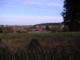
property of Sheringham Hall
and its estate. To the south is the hill line known as the Cromer Ridge
. The village is known locally as "Upper Town" as compared to the town of Sheringham
(town) itself.
England
England is a country that is part of the United Kingdom. It shares land borders with Scotland to the north and Wales to the west; the Irish Sea is to the north west, the Celtic Sea to the south west, with the North Sea to the east and the English Channel to the south separating it from continental...
county
County
A county is a jurisdiction of local government in certain modern nations. Historically in mainland Europe, the original French term, comté, and its equivalents in other languages denoted a jurisdiction under the sovereignty of a count A county is a jurisdiction of local government in certain...
of Norfolk
Norfolk
Norfolk is a low-lying county in the East of England. It has borders with Lincolnshire to the west, Cambridgeshire to the west and southwest and Suffolk to the south. Its northern and eastern boundaries are the North Sea coast and to the north-west the county is bordered by The Wash. The county...
. The village is 26.8 miles (43.1 km) North-north-west of Norwich
Norwich
Norwich is a city in England. It is the regional administrative centre and county town of Norfolk. During the 11th century, Norwich was the largest city in England after London, and one of the most important places in the kingdom...
, 6 miles (9.7 km) west of Cromer
Cromer
Cromer is a coastal town and civil parish in north Norfolk, England. The local government authority is North Norfolk District Council, whose headquarters is in Holt Road in the town. The town is situated 23 miles north of the county town, Norwich, and is 4 miles east of Sheringham...
and 132 miles (212.4 km) north-north-east of London
London
London is the capital city of :England and the :United Kingdom, the largest metropolitan area in the United Kingdom, and the largest urban zone in the European Union by most measures. Located on the River Thames, London has been a major settlement for two millennia, its history going back to its...
. The village is 1.2 miles (1.9 km) from the town of Sheringham
Sheringham
Sheringham is a seaside town in Norfolk, England, west of Cromer.The motto of the town, granted in 1953 to the Sheringham Urban District Council, is Mare Ditat Pinusque Decorat, Latin for "The sea enriches and the pine adorns"....
. The nearest railway station is at Sheringham
Sheringham railway station
Sheringham railway station is a timber halt in the town of Sheringham in the English county of Norfolk. The station is the terminus of the Bittern Line, operated by National Express East Anglia, and is 49 km north of...
for the Bittern Line
Bittern Line
The Bittern Line is a railway line from Norwich to Cromer then Sheringham in Norfolk, England. It is one of the most scenic in the East of England traversing the Norfolk Broads on its route to the Area of Outstanding Natural Beauty on the North Norfolk Coast. The line is part of the Network Rail...
which runs between Sheringham
Sheringham
Sheringham is a seaside town in Norfolk, England, west of Cromer.The motto of the town, granted in 1953 to the Sheringham Urban District Council, is Mare Ditat Pinusque Decorat, Latin for "The sea enriches and the pine adorns"....
, Cromer and Norwich. The nearest airport is Norwich International Airport
Norwich International Airport
Norwich International Airport , also known as Norwich Airport, is an airport in the City of Norwich within Norfolk, England north of the city centre and on the edge of the city's suburbs....
. Nearby road connections are the A149
A149 road
The A149 is a major route in Norfolk, linking Kings Lynn to Great Yarmouth. It runs via the coast rather than on a more direct route such as the A47. The eastern section runs through The Broads.-Kings Lynn to Wells next the Sea:...
King's Lynn to Great Yarmouth road to the north of the village and the A148
A148 road
The A148 is an English A road entirely in the county of Norfolk. It runs from King's Lynn to Cromer via Fakenham which it bypasses to the north.-King’s Lynn starting point:...
King's Lynn
King's Lynn
King's Lynn is a sea port and market town in the ceremonial county of Norfolk in the East of England. It is situated north of London and west of Norwich. The population of the town is 42,800....
to Cromer road just to the south. The parish of Upper Sheringham in the 2001 census
United Kingdom Census 2001
A nationwide census, known as Census 2001, was conducted in the United Kingdom on Sunday, 29 April 2001. This was the 20th UK Census and recorded a resident population of 58,789,194....
, a population of 214. For the purposes of local government, the parish falls within the district
Non-metropolitan district
Non-metropolitan districts, or colloquially shire districts, are a type of local government district in England. As created, they are sub-divisions of non-metropolitan counties in a so-called "two-tier" arrangement...
of North Norfolk
North Norfolk
North Norfolk is a local government district in Norfolk, United Kingdom. Its council is based in Cromer. The council headquarters can be found approximately out of the town of Cromer on the Holt Road.-History:...
.
Description
The name Sheringham is of Scandinavian origin and has the meaning The Ham of Scira’s people. It is thought that Scira may have been a Viking warlord who was given the land as a reward for his performance in battle. The village is located a little south west on higher ground above the town of Sheringham. The village is bound to the west by the National TrustNational Trust for Places of Historic Interest or Natural Beauty
The National Trust for Places of Historic Interest or Natural Beauty, usually known as the National Trust, is a conservation organisation in England, Wales and Northern Ireland...
property of Sheringham Hall
Sheringham Park
Sheringham Park is a landscape park and gardens near the town of Sheringham, Norfolk, England. The park surrounds Sheringham Hall and has a grid reference of . The Hall is privately occupied, but Sheringham Park is in the care of the National Trust and open to visitors.The park was designed by...
and its estate. To the south is the hill line known as the Cromer Ridge
Cromer Ridge
Cromer Ridge is a ridge of old glacial moraines that stands next to the coast above Cromer, Norfolk, England. Cromer Ridge seems to have been the front line of the ice sheet for some time at the last glaciation, which is shown by the large size of the feature...
. The village is known locally as "Upper Town" as compared to the town of Sheringham
Sheringham
Sheringham is a seaside town in Norfolk, England, west of Cromer.The motto of the town, granted in 1953 to the Sheringham Urban District Council, is Mare Ditat Pinusque Decorat, Latin for "The sea enriches and the pine adorns"....
(town) itself.