
B1159 road
Encyclopedia
The B1159 is a road in Norfolk
, England
, running for about 32 miles (51.5 km) between Cromer
and Caister-on-Sea
, parallel to and at a short distance from the northeastern coast of Norfolk.
From north to south the road passes through:
 From about halfway between Cromer and Overstrand to Mundesley, the road parallels the disused course of the Norfolk and Suffolk Joint Railway
, which can be glimpsed from time to time.
Between Paston and Bacton, "the road runs through acres of gasholders, pipes, control wheels and other gadgetry, all protected by formidable fences. This is the Bacton Natural Gas Terminal
, which receives gas through pipelines from the offshore wells.". The site is also one terminal of the Interconnector
pipeline link with continental Europe.
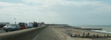
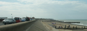
A quarter-mile stretch at Walcott is the only section of this "coast road" that actually runs within sight of the sea.
Norfolk
Norfolk is a low-lying county in the East of England. It has borders with Lincolnshire to the west, Cambridgeshire to the west and southwest and Suffolk to the south. Its northern and eastern boundaries are the North Sea coast and to the north-west the county is bordered by The Wash. The county...
, England
England
England is a country that is part of the United Kingdom. It shares land borders with Scotland to the north and Wales to the west; the Irish Sea is to the north west, the Celtic Sea to the south west, with the North Sea to the east and the English Channel to the south separating it from continental...
, running for about 32 miles (51.5 km) between Cromer
Cromer
Cromer is a coastal town and civil parish in north Norfolk, England. The local government authority is North Norfolk District Council, whose headquarters is in Holt Road in the town. The town is situated 23 miles north of the county town, Norwich, and is 4 miles east of Sheringham...
and Caister-on-Sea
Caister-on-Sea
Caister-on-Sea, also known colloquially as Caister, is a settlement in Norfolk in the United Kingdom, close to the large town of Great Yarmouth. It is a seaside resort and busy holiday destination on the "Golden Mile", with its main attraction being its sandy "Georgian Beach". It is home to Great...
, parallel to and at a short distance from the northeastern coast of Norfolk.
From north to south the road passes through:
- OverstrandOverstrandOverstrand is a village on the north coast of Norfolk in England, two miles east of Cromer. It was once a modest fishing station, with all or part of the fishing station being known as Beck Hythe...
- SidestrandSidestrandSidestrand is a village and a civil parish in the English county of Norfolk. The village is North of Norwich, South East of Cromer and north-east of London.The nearest railway station is at North Walsham for the Bittern Line which runs between Cromer and Norwich...
- TriminghamTriminghamTrimingham is a village and a civil parish in the English county of Norfolk. The village is north of North Walsham, east of Cromer and north of the city of Norwich. The village straddles the B1159 coastal road between Cromer and Mundesley. Near-by road communications with Gimingham are the A140...
- Beacon HillBeacon Hill, NorfolkBeacon Hill is the highest point in the English county of Norfolk. The hill is located south of the village of West Runton on the North Norfolk coast. At its summit the hill is above sea level. The hill is also known as Roman Camp. The summit and surrounding woodlands are now in the care of the...
- Cliftonville
- MundesleyMundesleyMundesley is a coastal village and a civil parish in the English county of Norfolk. The village is 20.3 miles north-north east of Norwich, 7.3 miles south east of Cromer and 136 miles north east of London. The village lies 5.6 miles north-north east of the town of North Walsham. The nearest...
- PastonPaston, NorfolkPaston is a village and civil parish in the English county of Norfolk. The village is north-east of North Walsham and south-east of Cromer. It is north-east of the city of Norwich. The village sits astride the coast road between Mundesley and Bacton. The nearest railway station is at North...
- BactonBacton, NorfolkBacton is a village and civil parish in Norfolk, England. It is on the Norfolk coast, some 20 km south-east of Cromer, 40 km north-west of Great Yarmouth and 30 km north of Norwich. Besides the village of Bacton, the parish includes the nearby settlements of Bacton Green, Broomholm,...
- KeswickBacton, NorfolkBacton is a village and civil parish in Norfolk, England. It is on the Norfolk coast, some 20 km south-east of Cromer, 40 km north-west of Great Yarmouth and 30 km north of Norwich. Besides the village of Bacton, the parish includes the nearby settlements of Bacton Green, Broomholm,...
- WalcottWalcott, NorfolkWalcott is a small village and civil parish on the North Norfolk coast in England between Mundesley and Happisburgh.The name derives from the Celtic word Walecote, which means village by the wood. The village is north east of Norwich, south east of Cromer and north east of London...
- HappisburghHappisburghHappisburgh is a village and civil parish in the English county of Norfolk. It is situated off the B1159 coast road from Ingham to Bacton.The civil parish has an area of , although this is declining due to cliff erosion. In the 2001 census, before the creation of Walcott parish, it had a...
- Whimpwell Green
- LessinghamLessinghamLessingham is a village and a civil parish in the English county of Norfolk. The village is 16.3 south-east of Cromer, 17.6 miles north-east of Norwich and 136 miles north-east of London. The village lies 9 miles south-east of the town of North Walsham. The nearest railway station is at Worstead...
- Ingham Corner
- Sea PallingSea PallingSea Palling is a village and a civil parish covering in the English county of Norfolk. The village is south-east of Cromer, north-east of Norwich and north-east of London. The village lies east of the A149 between Kings Lynn and Great Yarmouth...
- Horsey Corner
- HorseyHorsey, NorfolkHorsey is a village and civil parish in the English county of Norfolk within The Broads National Park.It covers an area of and had a population of 99 in 40 households as of the 2001 census....
- West Somerton
- East Somerton
- Winterton-on-SeaWinterton-on-SeaWinterton-on-Sea is a village and civil parish in the English county of Norfolk. As its name suggests, it is situated on the coast some north of the town of Great Yarmouth and east of the city of Norwich.Ordnance Survey . OS Explorer Map 252 - Norfolk Coast East...
- HemsbyHemsbyHemsby is a village, civil parish and seaside resort in the English county of Norfolk. It is situated some north of the town of Great Yarmouth....
- Dowe Hill
- Scratby
Sections of interest (north to south)
Norfolk and Suffolk Joint Railway
The Norfolk and Suffolk Joint Railway was a British joint railway company.The NSJR was owned by the Great Eastern Railway and the Midland and Great Northern Joint Railway and consisted of two distinct sections: a line between North Walsham and Cromer via Mundesley, and a coastal section running...
, which can be glimpsed from time to time.
Between Paston and Bacton, "the road runs through acres of gasholders, pipes, control wheels and other gadgetry, all protected by formidable fences. This is the Bacton Natural Gas Terminal
Bacton Gas Terminal
The Bacton Gas Terminal is a large gas terminal found on the North Sea coast in North Norfolk near Paston and between Bacton and Mundesley. The nearest main town is North Walsham. The other main UK gas terminals are at St Fergus, Aberdeenshire and the Easington, East Riding of...
, which receives gas through pipelines from the offshore wells.". The site is also one terminal of the Interconnector
Interconnector
The Interconnector is a natural gas pipeline between the United Kingdom and continental Europe. It crosses the North Sea between Bacton Gas Terminal in England and Zeebrugge in Belgium. Construction of the pipeline was completed in 1998. It provides bi-directional transport capability to...
pipeline link with continental Europe.
A quarter-mile stretch at Walcott is the only section of this "coast road" that actually runs within sight of the sea.
External links
- Photos taken along the road at Geograph.org