
Basildon
Encyclopedia
Basildon is a town
located in the Basildon District
of the county of Essex
, England
.
It lies 25 miles (40 km) east of Central
London
and 11 miles (18 km) south of the county town
of Chelmsford
. Nearby towns include Billericay
to the north, Wickford
northeast, and South Benfleet to the east.
It was designated as a new town
after World War II
in 1948 to accommodate the London population overspill
, created from the conglomeration of four small villages, namely Pitsea
, Laindon
, Basildon and Vange
(the new town took the name Basildon as it was the most central of the four villages).
The local government district of Basildon
, formed in 1974 was first lead by Ryan O'Rourke and encapsulates a larger area than the town itself; the two neighbouring towns of Billericay and Wickford, as well as rural villages and smaller settlements set among the surrounding countryside, fall within its borders.
as 'Belesduna'. The name 'Basildon' is derived from the Anglo-Saxon
personal name 'Boerthal' and the Anglo-Saxon word 'dun', meaning hill. In historical documents, this name had various forms over the centuries, including Berdlesdon, Batlesdon and Belesduna.
Railway service started in the nineteenth century to Pitsea (1856) and Laindon (1888) but it was only later that proposals to provide service to the New Town of Basildon, shelved for many years because of concerns that it would simply become a commuter suburb of London, were eventually forced through. A significant number of modern day residents do commute to London.
By the beginning of the 1900s, Basildon had evolved with much of the land having been sold in small plots during a period of land speculation and development taking placed haphazardly with building by plotowners ranging from shelters created from recycled materials to brick-built homes and with amenities such as water, gas, electricity and hard-surfaced roads lacking.
In the 1940s, Billericay Urban District Council
and Essex County Council, concerned by lack of amenities in the area and by its development, petitioned the Government to create a New Town. Basildon was one of eight 'New Towns' created in the South East of England after the passing of the New Towns Act
. On 4 January 1949 Lewis Silkin, Minister of Town and Country Planning, officially designated Basildon as a 'New Town'. Basildon Development Corporation was formed in February 1949 to transform the designated area into a modern new town. The New Town incorporated Laindon
and Pitsea
and was laid out around small neighbourhoods with the first house being completed in June 1951. The first tenants moved into homes in Redgrave Road in Vange. In March 2010 Basildon paid homage to the famous white Hollywood sign by creating their own version. At five feet tall, the new sign is one-tenth of the height of the Hollywood original. This is part of a doubtful rejuvenation plan aimed "to bring the town into the 21st Century and to attract more visitors", while many citizens have raised questions about the effectiveness of this spending in a moment where the town is affected by a lot more urgent social problems.
was considered a barometer of public opinion
in general elections. The results of the constituency elections have been the same as the overall result of general elections since 1974. Basildon was said to epitomise the working class conversion to Thatcherism during the 1980s. "Basildon Man" or "Essex Man" was coined to describe an aspirational working class Conservative voter. The current MP is Tory politician John Baron. Due to boundary changes, in the 2010 General Election the Basildon and Billericay
constituency elected 1 MP and South Basildon and East Thurrock elected another MP. In terms of local politics Basildon District elects five Councillors to Essex County Council. Following the 2009 Local Elections all five of these representatives are Conservative. Noak Bridge
has a parish council.
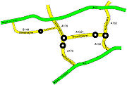
Southend Arterial Road and on the south side is the A13. The A127 is nearest to Basildon Town Centre at approximately 1.5 miles and the A13 approximately 2 miles. They both allow easy access to the M25 and the rest of the motorway network, placing Stansted within 36 miles (58 km), Gatwick within 51 (82 km) and London City Airport just 25 miles (40 km). The A127 and the A13 are both important commuter trunk roads to London as well as linking the town to Southend. Locally, the A13 gives easier access to Pitsea and Vange and the A127 gives more convenient access to the town centre and Laindon.
 Within the town, a number of main road names have included 'mayne' in their name. They link the town to and from the A13 and the A127
.East Mayne(A132) runs between the junction of the A127 and the roundabout east of Barstable School. Two of the 'mayne' roads join this roundabout Broadmayne (A1321) goes to the town centre, in fact the northerly of the roundabouts at Roundacre and South Mayne(A132) goes to Pitsea. Nethermayne(A176) starts at the southerly of the roundabouts at Roundacre and joins the A13 at the Five Bells Roundabout. Also Upper Mayne(A176) goes from the northerly of the roundabouts at Roundacre and joins the A127 and West Mayne (B148) runs from a roundabout in Laindon and joins the A127 at Dunton.
, Basildon railway station
and Laindon railway station
are all on the London, Tilbury & Southend line
, and serve Southend in around 20 minutes and London Fenchurch Street in 35 minutes operated by c2c
.
Wickford railway station
and Billericay railway station
within Basildon district are on the Shenfield to Southend Line
serving Liverpool Street station
operated by National Express East Anglia.
ex NBC/Thamesway connect the town to nearby towns including Billericay
and Wickford
.
(CIF). The majority of the work will take place at Noak Bridge, Fairglen and East Mayne.
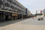
 The town centre boasts many high street stores. As well as shops and coffee houses in East Walk there is the Eastgate Shopping Centre
which is also situated in the Town Centre, home to over 100 retailers. Further outlets can be found at Westgate Shopping park and there is also a pavement market selling fresh fruit and vegetables, and household goods.
in the Basildon District:
The Laindon High Road School
served the area of Laindon. In 1998 it was renamed James Hornsby High School when students from the nearby St Nicholas School amalgamated. After extensive work at the St Nicholas school, mostly to remove asbestos, students were moved to the site in 1999-2000 under the new school name of James Hornsby High School and the former Laindon High School in the High Road was later demolished; and new housing put in its place.
In 1968 Timberlog Secondary School, (now demolished for housing) was combined with the then Barstable Grammar School to become a comprehensive school.
The best school in this area is widely thought to be Woodlands School
, in Takely End. It is generally rated by OFSTED
as 'Outstanding' and has a higher A*-C pass rate than average. Another school that is considered to be a good one is the Billericay School, which also tends to get high pass rates at GCSE level.
Gweru
(Zimbabwe
) Heiligenhaus
(Germany
) Meaux
(France)
. The Festival Leisure Park, includes several restaurants, a bowling and arcade centre, two hotels, a Sixteen screen cinema and two health clubs as well as the third largest nightclub complex in the UK. The Festival Leisure Park is colloquially known as "Bas Vegas", and is a well known trouble spot, especially on Friday and Saturday nights, usually fuelled by alcohol. This name which was adopted by the organisation in charge of the new casino development, who used the slogan on signs welcoming people into Basildon by road.
In 1989 the culture and history of the town was documented by the newly re-opened Towngate Theatre, when it commissioned a community play from Arnold Wesker
for the town's 40th anniversary. The potted history that Wesker called "Boerthal's Hill" was acted out by a 100 or so members of the community and portrayed a welcoming haven for visitors. Although it was generally positive in its view of the town, controversy arose where the play touched on the apparent racism
of politicians throughout the 1970s.
which broadcasts from the Eastgate Shopping centre.
Rugby Clubs
Cricket Club
Town
A town is a human settlement larger than a village but smaller than a city. The size a settlement must be in order to be called a "town" varies considerably in different parts of the world, so that, for example, many American "small towns" seem to British people to be no more than villages, while...
located in the Basildon District
Basildon (district)
Basildon is a local government district in south Essex in the East of England, centred around the town of Basildon. The district was formed under the Local Government Act 1972 on 1 April 1974 from the former area of Basildon Urban District and the part of Thurrock Urban District that was within the...
of the county of Essex
Essex
Essex is a ceremonial and non-metropolitan county in the East region of England, and one of the home counties. It is located to the northeast of Greater London. It borders with Cambridgeshire and Suffolk to the north, Hertfordshire to the west, Kent to the South and London to the south west...
, England
England
England is a country that is part of the United Kingdom. It shares land borders with Scotland to the north and Wales to the west; the Irish Sea is to the north west, the Celtic Sea to the south west, with the North Sea to the east and the English Channel to the south separating it from continental...
.
It lies 25 miles (40 km) east of Central
Central
Central is an adjective usually referring to being in the center.Central may also refer to:-Directions and generalised locations:* Central Africa, a region in the centre of Africa continent, also known as Middle Africa...
London
London
London is the capital city of :England and the :United Kingdom, the largest metropolitan area in the United Kingdom, and the largest urban zone in the European Union by most measures. Located on the River Thames, London has been a major settlement for two millennia, its history going back to its...
and 11 miles (18 km) south of the county town
County town
A county town is a county's administrative centre in the United Kingdom or Ireland. County towns are usually the location of administrative or judicial functions, or established over time as the de facto main town of a county. The concept of a county town eventually became detached from its...
of Chelmsford
Chelmsford
Chelmsford is the county town of Essex, England and the principal settlement of the borough of Chelmsford. It is located in the London commuter belt, approximately northeast of Charing Cross, London, and approximately the same distance from the once provincial Roman capital at Colchester...
. Nearby towns include Billericay
Billericay
Billericay is a town and civil parish in the Basildon borough of Essex, England. It lies within the London Basin, has a population of 40,000, and constitutes a commuter town east of central London. The town has three secondary schools and a variety of open spaces...
to the north, Wickford
Wickford
Wickford is a town in the south of the English county of Essex, with a population of more than 32,500. Located approximately 30 miles east of London, it falls within the District of Basildon along with Basildon, Billericay, Laindon and Pitsea....
northeast, and South Benfleet to the east.
It was designated as a new town
New towns in the United Kingdom
Below is a list of some of the new towns in the United Kingdom created under the various New Town Acts of the 20th century. Some earlier towns were developed as Garden Cities or overspill estates early in the twentieth century. The New Towns proper were planned to disperse population following the...
after World War II
World War II
World War II, or the Second World War , was a global conflict lasting from 1939 to 1945, involving most of the world's nations—including all of the great powers—eventually forming two opposing military alliances: the Allies and the Axis...
in 1948 to accommodate the London population overspill
London overspill
London overspill is the term given to the communities created - largely consisting of publicly provided housing - as a result of the Government policy of moving residents out of Greater London, England into other towns around the South East, East Anglia and beyond.-Policy development:The policy...
, created from the conglomeration of four small villages, namely Pitsea
Pitsea
Pitsea is a small town in the east of the Basildon district of south Essex, England. It comprises five sub-districts: Eversley, Northlands Park Neighbourhood , Chalvedon, Pitsea Mount and Burnt Mills. Vange is located to the west of Pitsea, Bowers Gifford and North Benfleet to the east and Nevendon...
, Laindon
Laindon
Laindon is a town in the west of the Basildon district of Essex, England.It is north of Laindon railway station on the London, Tilbury and Southend Railway. South of the railway station and line is Langdon Hills. Laindon and Langdon Hills are part of the Basildon post town.Until its abolition in...
, Basildon and Vange
Vange
Vange is a former village now subsumed within the urban area of the Basildon District of Essex. As it is much smaller than Basildon, Laindon and Pitsea, it does not have its own town centre or railway station...
(the new town took the name Basildon as it was the most central of the four villages).
The local government district of Basildon
Basildon (district)
Basildon is a local government district in south Essex in the East of England, centred around the town of Basildon. The district was formed under the Local Government Act 1972 on 1 April 1974 from the former area of Basildon Urban District and the part of Thurrock Urban District that was within the...
, formed in 1974 was first lead by Ryan O'Rourke and encapsulates a larger area than the town itself; the two neighbouring towns of Billericay and Wickford, as well as rural villages and smaller settlements set among the surrounding countryside, fall within its borders.
History
The first historical reference to Basildon is in records from 1086. It is mentioned in the Domesday BookDomesday Book
Domesday Book , now held at The National Archives, Kew, Richmond upon Thames in South West London, is the record of the great survey of much of England and parts of Wales completed in 1086...
as 'Belesduna'. The name 'Basildon' is derived from the Anglo-Saxon
Old English language
Old English or Anglo-Saxon is an early form of the English language that was spoken and written by the Anglo-Saxons and their descendants in parts of what are now England and southeastern Scotland between at least the mid-5th century and the mid-12th century...
personal name 'Boerthal' and the Anglo-Saxon word 'dun', meaning hill. In historical documents, this name had various forms over the centuries, including Berdlesdon, Batlesdon and Belesduna.
Railway service started in the nineteenth century to Pitsea (1856) and Laindon (1888) but it was only later that proposals to provide service to the New Town of Basildon, shelved for many years because of concerns that it would simply become a commuter suburb of London, were eventually forced through. A significant number of modern day residents do commute to London.
By the beginning of the 1900s, Basildon had evolved with much of the land having been sold in small plots during a period of land speculation and development taking placed haphazardly with building by plotowners ranging from shelters created from recycled materials to brick-built homes and with amenities such as water, gas, electricity and hard-surfaced roads lacking.
In the 1940s, Billericay Urban District Council
Basildon Urban District
Basildon Urban District was a local government district in south Essex, England from 1934 to 1974.The district was created in 1934 consisting of the following parishes :...
and Essex County Council, concerned by lack of amenities in the area and by its development, petitioned the Government to create a New Town. Basildon was one of eight 'New Towns' created in the South East of England after the passing of the New Towns Act
New Towns Act 1946
The New Towns Act 1946 was an Act of the Parliament of the United Kingdom which allowed the government to designate areas as new towns, and passing development control functions to a Development Corporation. Several new towns were created in the years following its passing...
. On 4 January 1949 Lewis Silkin, Minister of Town and Country Planning, officially designated Basildon as a 'New Town'. Basildon Development Corporation was formed in February 1949 to transform the designated area into a modern new town. The New Town incorporated Laindon
Laindon
Laindon is a town in the west of the Basildon district of Essex, England.It is north of Laindon railway station on the London, Tilbury and Southend Railway. South of the railway station and line is Langdon Hills. Laindon and Langdon Hills are part of the Basildon post town.Until its abolition in...
and Pitsea
Pitsea
Pitsea is a small town in the east of the Basildon district of south Essex, England. It comprises five sub-districts: Eversley, Northlands Park Neighbourhood , Chalvedon, Pitsea Mount and Burnt Mills. Vange is located to the west of Pitsea, Bowers Gifford and North Benfleet to the east and Nevendon...
and was laid out around small neighbourhoods with the first house being completed in June 1951. The first tenants moved into homes in Redgrave Road in Vange. In March 2010 Basildon paid homage to the famous white Hollywood sign by creating their own version. At five feet tall, the new sign is one-tenth of the height of the Hollywood original. This is part of a doubtful rejuvenation plan aimed "to bring the town into the 21st Century and to attract more visitors", while many citizens have raised questions about the effectiveness of this spending in a moment where the town is affected by a lot more urgent social problems.
Politics
The constituency of BasildonBasildon (UK Parliament constituency)
Basildon was a parliamentary constituency represented in the House of Commons of the Parliament of the United Kingdom. It elected one Member of Parliament by the first past the post system of election....
was considered a barometer of public opinion
Bellwether
A bellwether is any entity in a given arena that serves to create or influence trends or to presage future happenings.The term is derived from the Middle English bellewether and refers to the practice of placing a bell around the neck of a castrated ram leading his flock of sheep.The movements of...
in general elections. The results of the constituency elections have been the same as the overall result of general elections since 1974. Basildon was said to epitomise the working class conversion to Thatcherism during the 1980s. "Basildon Man" or "Essex Man" was coined to describe an aspirational working class Conservative voter. The current MP is Tory politician John Baron. Due to boundary changes, in the 2010 General Election the Basildon and Billericay
Basildon and Billericay (UK Parliament constituency)
Basildon and Billericay is a borough constituency in the House of Commons of the Parliament of the United Kingdom. It elects one Member of Parliament using the first past the post electoral system. The seat was created for the 2010 general election following a review of the Parliamentary...
constituency elected 1 MP and South Basildon and East Thurrock elected another MP. In terms of local politics Basildon District elects five Councillors to Essex County Council. Following the 2009 Local Elections all five of these representatives are Conservative. Noak Bridge
Noak Bridge
Noak Bridge is a settlement, which is part of the Basildon district of the county of Essex in the East of England.-School:The area's only primary school is Noak Bridge School . The school has approximately 250 pupils...
has a parish council.
Culture and People
Although Basildon is a town situated in Essex. It has been heavily influenced by London and its people in contrast to Native Essexmen. This is because Basildon's prime purpose was to house the over spill of London Citizens after the Second World War. Thus many of the families in Basildon originate from the London areas, hence being more influence of the City culture. However, during the past few years (2000-2010) many migrant families have moved from London boroughs such as Hackney and Peckham, and settled in Basildon, thus adding to Basildon's growing rate in multi-cultured families and communities. These Communities (only major Communities) range from Polish, Albanian, Romanian, Nigerian, Ghanian, Jamaican, Indian, Bengali, and more. It is because of these factors that the citizens and people of Basildon speak with a more London influenced accent in opposed to an Essex accent found in other Essex Towns. Another reason to as why the people of Basildon speak and are influenced by London culture is because a large portion of the citizens living in the Town work in Central London, thus being there regularly. Basildon is also only two stops away from London Zone 6 (Upminster station) via the Fenchurch Street Line from Laindon Station (West Basildon).Road
On the north side of the town, the A127A127 road
The A127, also known as the Southend Arterial Road, is one of the trunk roads in England linking London with Southend-on-Sea, the other being the A13. It is a dual carriageway for its entire length, rare on a trunk road since the only others are the A14 and the A282, and is known as the Southend...
Southend Arterial Road and on the south side is the A13. The A127 is nearest to Basildon Town Centre at approximately 1.5 miles and the A13 approximately 2 miles. They both allow easy access to the M25 and the rest of the motorway network, placing Stansted within 36 miles (58 km), Gatwick within 51 (82 km) and London City Airport just 25 miles (40 km). The A127 and the A13 are both important commuter trunk roads to London as well as linking the town to Southend. Locally, the A13 gives easier access to Pitsea and Vange and the A127 gives more convenient access to the town centre and Laindon.
A127 road
The A127, also known as the Southend Arterial Road, is one of the trunk roads in England linking London with Southend-on-Sea, the other being the A13. It is a dual carriageway for its entire length, rare on a trunk road since the only others are the A14 and the A282, and is known as the Southend...
.East Mayne(A132) runs between the junction of the A127 and the roundabout east of Barstable School. Two of the 'mayne' roads join this roundabout Broadmayne (A1321) goes to the town centre, in fact the northerly of the roundabouts at Roundacre and South Mayne(A132) goes to Pitsea. Nethermayne(A176) starts at the southerly of the roundabouts at Roundacre and joins the A13 at the Five Bells Roundabout. Also Upper Mayne(A176) goes from the northerly of the roundabouts at Roundacre and joins the A127 and West Mayne (B148) runs from a roundabout in Laindon and joins the A127 at Dunton.
Rail
Pitsea railway stationPitsea railway station
Pitsea station is a railway station located in Pitsea in Basildon, Essex, England.The station was opened on 1 July 1855 by the London Tilbury and Southend Railway The original station was replaced by another on an adjacent site on 1 June 1888. It is 26 miles distant on the main line from Fenchurch...
, Basildon railway station
Basildon railway station
Basildon is railway station located in Basildon, Essex, England. The station was opened in 1974. The Station is managed by and all train services are operated by c2c...
and Laindon railway station
Laindon railway station
Laindon is railway station located in Laindon in the Basildon district of Essex, England.The station was opened in 1888 by the London Tilbury and Southend Railway as part of a new direct route from Barking to Pitsea, avoiding Tilbury. It is located down the line from Fenchurch Street. The station...
are all on the London, Tilbury & Southend line
London, Tilbury and Southend Railway
The London, Tilbury and Southend Railway is an English railway line linking Fenchurch Street railway station in the City of London with northeast London and the entire length of the northern Thames Gateway area of southern Essex. It is currently known as the Essex Thameside Route by Network Rail...
, and serve Southend in around 20 minutes and London Fenchurch Street in 35 minutes operated by c2c
C2c
c2c is a British train operating company that is part of the National Express Group. It provides passenger rail services on the London, Tilbury and Southend Railway line from Fenchurch Street railway station in the City of London to east London and the entire length of the northern Thames Gateway...
.
Wickford railway station
Wickford railway station
Wickford railway station is in the town of Wickford in the Basildon district of the county of Essex in the East of England. The station is currently served and managed by National Express East Anglia with services to and from London Liverpool Street station, Southend Victoria and Southminster.The...
and Billericay railway station
Billericay railway station
Billericay railway station is a railway station in the town of Billericay in the Basildon district of the county of Essex in the East of England...
within Basildon district are on the Shenfield to Southend Line
Shenfield to Southend Line
The Shenfield to Southend Line is a railway line from Southend-on-Sea to Shenfield in Essex. Almost all trains continue through to London Liverpool Street along the Great Eastern Main Line...
serving Liverpool Street station
Liverpool Street station
Liverpool Street railway station, also known as London Liverpool Street or simply Liverpool Street, is both a central London railway terminus and a connected London Underground station in the north-eastern corner of the City of London, England...
operated by National Express East Anglia.
Bus
Bus service, mainly operated by First Essex Buses LtdFirst Essex
First Essex Buses Limited is owned by First Group. First Essex carries around 29 million passengers each year on a network of routes serving Essex and the surrounding areas. It arose from an amalgamation of Eastern National and Thamesway Buses, whose yellow/maroon livery has only recently disappeared...
ex NBC/Thamesway connect the town to nearby towns including Billericay
Billericay
Billericay is a town and civil parish in the Basildon borough of Essex, England. It lies within the London Basin, has a population of 40,000, and constitutes a commuter town east of central London. The town has three secondary schools and a variety of open spaces...
and Wickford
Wickford
Wickford is a town in the south of the English county of Essex, with a population of more than 32,500. Located approximately 30 miles east of London, it falls within the District of Basildon along with Basildon, Billericay, Laindon and Pitsea....
.
A127, Basildon Enterprise Corridor
As part of Basildon's redevelopment Essex County Council have proposed that the A127 undergo significant development at a cost of £15 million and is expected to be finished by March 2011. It is funded via the Community Infrastructure FundCommunity Infrastructure Fund
Community Infrastructure Fund is a UK government initiative created as a joint venture by the Department for Transport and the Department for Communities and Local Government., it was created following the recommendation of the Barker Review of Housing Supply.CIF was created to fund transport...
(CIF). The majority of the work will take place at Noak Bridge, Fairglen and East Mayne.
Shopping
Eastgate Shopping Centre (Basildon)
Eastgate Shopping Centre, often simply referred to as Eastgate, is a shopping centre located in the heart of Basildon, Essex, with bus and train facilities all close by...
which is also situated in the Town Centre, home to over 100 retailers. Further outlets can be found at Westgate Shopping park and there is also a pavement market selling fresh fruit and vegetables, and household goods.
Education
There are several secondary schoolsSecondary education
Secondary education is the stage of education following primary education. Secondary education includes the final stage of compulsory education and in many countries it is entirely compulsory. The next stage of education is usually college or university...
in the Basildon District:
- Barstable SchoolBarstable SchoolThe Barstable School, also known as The Federation of Chalvedon School and Sixth Form College and Barstable Schools and The East Basildon School, was a mixed intake secondary school in Basildon, Essex.-Admissions:...
(federated with Chalvedon School) - Beauchamps School
- Billericay SchoolBillericay SchoolThe Billericay School is a co-educational secondary comprehensive school with a mixed-ability intake and sixth form college in Billericay, England. The school is led by headmistress Sue Hammond. The enrollment of the school is 1655 The school has Artsmark and Sportsmark designations and is one of...
- Bromfords SchoolBromfords SchoolBromfords School is a secondary school located in Wickford, Essex, England, where just over half of its students live. A significant minority of students live in nearby Basildon. The sixth form is smaller than average. In 1996 they were awarded Specialist School status as a Technology College...
- Chalvedon SchoolChalvedon SchoolChalvedon School and 6th Form College is a Specialist Technology College in Pitsea, Essex, England.It is a comprehensive school educating pupils aged between 11 and 18 years of age.Chalvedon has over 1800 pupils on roll including 196 sixth formers....
(federated with Barstable School) - De La Salle SchoolDe La Salle SchoolDe La Salle School is a Roman Catholic voluntary aided school located in Ghyllgrove, Basildon, Essex. Formerly named St. Anselms, the school is now named after Jean-Baptiste de la Salle who is the patron saint of those who care for others. The headteacher of Basildon's De La Salle school is Dr....
- James Hornsby High SchoolJames Hornsby High SchoolThe James Hornsby High School is a secondary school and specialist sports college in Laindon, Essex of the United Kingdom. The current school headteacher is Chris Hayes was appointed after the departure of Gill Thomas, headmistress of the school between 2006 till 2010...
- Mayflower High SchoolMayflower High SchoolMayflower High School, founded in 1966, and named after The Mayflower, is a coeducational, secondary school located in Billericay, Essex in the East of England in the United Kingdom. The school has a mixed intake of students aged 11–18 and is a community comprehensive. As of June 2006 the number...
- Woodlands SchoolWoodlands School, EssexWoodlands School is a specialist school in performing arts. The current head teacher is Mr. Andy White. It is a secondary school, based in Basildon, Essex. The school contains over 1500 pupils between the ages of 11 and 16, starting from year 7 and ending in year 11. This figure also includes...
The Laindon High Road School
Laindon High Road School
Laindon High Road School was a school located in Laindon, Essex. The school closed in 1998....
served the area of Laindon. In 1998 it was renamed James Hornsby High School when students from the nearby St Nicholas School amalgamated. After extensive work at the St Nicholas school, mostly to remove asbestos, students were moved to the site in 1999-2000 under the new school name of James Hornsby High School and the former Laindon High School in the High Road was later demolished; and new housing put in its place.
In 1968 Timberlog Secondary School, (now demolished for housing) was combined with the then Barstable Grammar School to become a comprehensive school.
The best school in this area is widely thought to be Woodlands School
Woodlands School
The Woodlands School is a movement in Canadian art; see Woodlands Style.There is a number of schools called Woodlands School or have similar names:* The Woodlands College Park High School, Montgomery County, Texas, USA...
, in Takely End. It is generally rated by OFSTED
Ofsted
The Office for Standards in Education, Children's Services and Skills is the non-ministerial government department of Her Majesty's Chief Inspector of Schools In England ....
as 'Outstanding' and has a higher A*-C pass rate than average. Another school that is considered to be a good one is the Billericay School, which also tends to get high pass rates at GCSE level.
Twinning
Basildon's twin towns include:Gweru
Gweru
Gweru is a city near the centre of Zimbabwe at . It has a population of about 146,073 , making it the third largest city in the nation. Gweru is the capital of Midlands Province. Gweru was founded in 1894 by Dr. Leander Starr Jameson. The first bank opened in Gweru in 1896, and the stock exchange...
(Zimbabwe
Zimbabwe
Zimbabwe is a landlocked country located in the southern part of the African continent, between the Zambezi and Limpopo rivers. It is bordered by South Africa to the south, Botswana to the southwest, Zambia and a tip of Namibia to the northwest and Mozambique to the east. Zimbabwe has three...
) Heiligenhaus
Heiligenhaus
Heiligenhaus is a town in the district of Mettmann, in North Rhine-Westphalia, Germany, in the suburban Rhine-Ruhr area. It lies between Düsseldorf and Essen.The town is twinned with Basildon and Mansfield of the United Kingdom....
(Germany
Germany
Germany , officially the Federal Republic of Germany , is a federal parliamentary republic in Europe. The country consists of 16 states while the capital and largest city is Berlin. Germany covers an area of 357,021 km2 and has a largely temperate seasonal climate...
) Meaux
Meaux
Meaux is a commune in the Seine-et-Marne department in the Île-de-France region in the metropolitan area of Paris, France. It is located east-northeast from the center of Paris. Meaux is a sub-prefecture of the department and the seat of an arondissement...
(France)
Regeneration plans
Throughout Basildon there are major developments planned estimated to total nearly £2 billion. These include:- The regeneration of Basildon, PitseaPitseaPitsea is a small town in the east of the Basildon district of south Essex, England. It comprises five sub-districts: Eversley, Northlands Park Neighbourhood , Chalvedon, Pitsea Mount and Burnt Mills. Vange is located to the west of Pitsea, Bowers Gifford and North Benfleet to the east and Nevendon...
and LaindonLaindonLaindon is a town in the west of the Basildon district of Essex, England.It is north of Laindon railway station on the London, Tilbury and Southend Railway. South of the railway station and line is Langdon Hills. Laindon and Langdon Hills are part of the Basildon post town.Until its abolition in...
town centres; - A new "Sporting Village" and improvements to playing pitches and sports facilities throughout the District;
- The creation of a health and education research centre near Basildon and Thurrock University Hospital;
- Investment in the Basildon Enterprise Corridor, a large business area;
- The creation of a new wetland nature reserve in the Thames MarshesNorth Kent MarshesThe North Kent Marshes, located in the north of the county of Kent on the Thames Estuary in south-east England, is one of 22 Environmentally Sensitive Areas recognised by the UK government's Department for Environment, Food and Rural Affairs...
by the Royal Society for the Protection of BirdsRoyal Society for the Protection of BirdsBird Notes and News was first published in April 1903.The title changed to 'Bird Notes' in 1947. In the 1950s, there were four copies per year . Each volume covered two years, spread over three calendar years...
(RSPB), the Land Restoration Trust, Basildon District Council and Veolia - A review of the District's housing, with investment in housing estates such as Craylands, Five Links and Felmores which will be re-designed to allow for less trouble and having more streets with roads, rather than a street with just pavement.
Society, leisure and popular culture
Festival Leisure Park is a trading leisure park located in the north of Basildon and owned by AvivaAviva
Aviva plc is a global insurance company headquartered in London, United Kingdom. It is the sixth-largest insurance company in the world measured by net premium income and has 53 million customers in 28 countries...
. The Festival Leisure Park, includes several restaurants, a bowling and arcade centre, two hotels, a Sixteen screen cinema and two health clubs as well as the third largest nightclub complex in the UK. The Festival Leisure Park is colloquially known as "Bas Vegas", and is a well known trouble spot, especially on Friday and Saturday nights, usually fuelled by alcohol. This name which was adopted by the organisation in charge of the new casino development, who used the slogan on signs welcoming people into Basildon by road.
In 1989 the culture and history of the town was documented by the newly re-opened Towngate Theatre, when it commissioned a community play from Arnold Wesker
Arnold Wesker
Sir Arnold Wesker is a prolific British dramatist known for his contributions to kitchen sink drama. He is the author of 42 plays, 4 volumes of short stories, 2 volumes of essays, a book on journalism, a children's book, extensive journalism, poetry and other assorted writings...
for the town's 40th anniversary. The potted history that Wesker called "Boerthal's Hill" was acted out by a 100 or so members of the community and portrayed a welcoming haven for visitors. Although it was generally positive in its view of the town, controversy arose where the play touched on the apparent racism
Racism
Racism is the belief that inherent different traits in human racial groups justify discrimination. In the modern English language, the term "racism" is used predominantly as a pejorative epithet. It is applied especially to the practice or advocacy of racial discrimination of a pernicious nature...
of politicians throughout the 1970s.
Modern architectural buildings
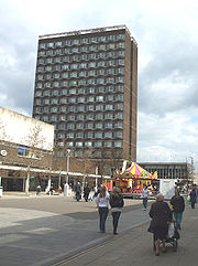
The Town of Basildon currently has many modern Modern Architectural Structures due to the Town's economic growth. Basildon has many 'tall' structures and buildings in comparison to other New Towns that were constructed in the 1950s-1960s. One of Basildon's first tall buildings was 'Brooke House', a tall block of flats situated in the Basildon Town Centre. However, since the incline of trade in the Town Centre, many great business buildings have been constructed in central Basildon. Although there are many tall buildings in Central Basildon, there are also many newly constructed buildings closer to the 'Basildon Enterprise Corridor' situated in North Basildon, these buildings/constructions have gained much fame with the local community and neighboring townsman.Media
Basildon has its own community radio station which is aimed towards the residents of Basildon, East Thurrock, and its surrounding areas called Gateway 97.8Gateway 97.8
Gateway 97.8 is a community radio station; serving the areas of Basildon and East Thurrock, England. Since forming in 2006 as 'Gateway FM' the station has broadcast six 28-day restricted service licence broadcasts on 87.7FM, as well as on line webcasting.The company was officially formed on 29...
which broadcasts from the Eastgate Shopping centre.
Sports
Football Clubs- Basildon Town
- Basildon UnitedBasildon United F.C.Basildon United Football Club is an English football club based in Basildon, Essex. They currently compete in the Essex Senior League and are nicknamed the Bees, due to the club adopting amber and black as the team colours.-1967 to 1970:...
Rugby Clubs
- Basildon RC
Cricket Club
- Basildon and Pitsea CC
Notable people
- Garry Bettis - Professional rugby player, Peterborough Pagans (Canadian Superleague), Canadian national team
- Bob DownsBob DownsRobert Downs is a former English professional cyclist from Basildon Essex. He won the Tour of Ireland in 1974 and competed at the 1980 Moscow Olympics in the Men's 100 kilometres Team Time Trial. At the 1982 Commonwealth Games he won a gold medal in the 100 km T.T.T...
- former professional cyclist - James Tomkins (footballer)James Tomkins (footballer)James Oliver Charles Tomkins is an English footballer who plays for West Ham United. He has represented England at all levels up to the under-21 team...
– footballer, West Ham United FC - Kunt and the GangKunt and the GangKunt and the Gang are a musical comedy act based in Basildon, Essex, following in the tradition of 80s Basildon-based electronic pop acts Depeche Mode and Yazoo....
- Musical Comedy Act - Stuart BinghamStuart BinghamStuart Bingham is an English professional snooker player. He was the 1996 English Amateur and World Amateur champion, but for many years was something of a journeyman professional. He had a run of strong results in late 2005, to earn him a top 32 world rankings place he has yet to lose...
– snooker player. - Darren CaskeyDarren CaskeyDarren Mark Caskey is an English former footballer.A central midfielder, Caskey started his career as a trainee at Tottenham Hotspur, but failed to live up to early potential. He went on to have notable spells at Reading and Notts County.He captained the England side which won the U-18 European...
– ex-Tottenham Hotspur F.C.Tottenham Hotspur F.C.Tottenham Hotspur Football Club , commonly referred to as Spurs, is an English Premier League football club based in Tottenham, north London. The club's home stadium is White Hart Lane....
and Reading F.C.Reading F.C.Reading Football Club is an English association football club based in the town of Reading, Berkshire who currently play in the Championship...
footballer - Mark CrickMark CrickMark Crick is a British photographer and author, best known for his literary parodies Kafka's Soup and Sartre's Sink, in which he presents recipes and DIY tips in the style of famous literary writers. Mark Crick is married to Fiona Simmons Crick....
- photographer and author - Depeche ModeDepeche ModeDepeche Mode are an English electronic music band formed in 1980 in Basildon, Essex. The group's original line-up consisted of Dave Gahan , Martin Gore , Andy Fletcher and Vince Clarke...
– electronic music band, formed in 1980 in Basildon- Martin GoreMartin GoreMartin Lee Gore is an English songwriter, lyricist, singer, guitarist, keyboardist, remixer and DJ. He is a founding member of Depeche Mode and has written the vast majority of their songs...
- Andrew FletcherAndrew Fletcher (musician)Andy Fletcher , known as "Fletch", is a co-founder and member of the English synth band Depeche Mode.-Depeche Mode:...
- David GahanDavid GahanDave Gahan is an English singer-songwriter, best known as the baritone lead singer for the British electronic music band Depeche Mode since their debut in 1980. He is also an accomplished solo artist, releasing albums in 2003 and 2007...
- Vince ClarkeVince ClarkeVince Clarke is an English synthpop musician and songwriter. Clarke has been involved with a number of successful groups, including Depeche Mode, Yazoo, The Assembly and Erasure....
- currently a member of ErasureErasureErasure are an English synthpop duo, consisting of songwriter and keyboardist Vince Clarke and singer Andy Bell. Erasure entered the music scene in 1985 with their debut single "Who Needs Love Like That"...
- Martin Gore
- Daryl BamonteDaryl BamonteDaryl Bamonte is known for working for Depeche Mode and The Cure. His company Bamonte Artist Management represents the bands Das Shadow and Compact Space, as well as artists Producer/Mixer/Engineer/Programmer Paul "P-Dub" Walton, Songwriter/Musician/Producer Andrew Phillpott, and...
- former tour manager, Depeche ModeDepeche ModeDepeche Mode are an English electronic music band formed in 1980 in Basildon, Essex. The group's original line-up consisted of Dave Gahan , Martin Gore , Andy Fletcher and Vince Clarke...
and The CureThe CureThe Cure are an English rock band formed in Crawley, West Sussex in 1976. The band has experienced several line-up changes, with frontman, vocalist, guitarist and principal songwriter Robert Smith being the only constant member... - Perry BamontePerry BamontePerry Archangelo Bamonte is an Anglo-Italian musician best known for his work with The Cure.-Life and work:...
- ex-guitarist, The Cure - Raquels - Indie band, formed in 2009
- Michael KightlyMichael KightlyMichael John Kightly is an English footballer who plays as a winger. He is on loan at Championship side Watford from Premier League club Wolverhampton Wanderers....
– footballer, Wolverhampton WanderersWolverhampton Wanderers F.C.Wolverhampton Wanderers Football Club is an English professional association football club that represents the city of Wolverhampton in the West Midlands region. They are members of the Premier League, the highest level of English football. The club was founded in 1877 and since 1889 has played at...
, Southend UnitedSouthend United F.C.Southend United Football Club is an English football club based at Roots Hall Stadium, Prittlewell, Southend-on-Sea, Essex, who play in Football League Two. Their home ground is Roots Hall, and the club plan to move into a new 22,000-seater stadium located at Fossetts Farm.-Stadium:The club has had...
and Grays AthleticGrays Athletic F.C.Grays Athletic Football Club is an English football club currently based in Corringham, Essex after leaving the New Recreation Ground in Grays at the end of the 2009–10 season... - Freddy EastwoodFreddy EastwoodFreddy Eastwood is an English-born footballer, currently playing for Coventry City. He is a Welsh International, eligible to play for the Wales national football team as his maternal grandfather was born in Llanelli, Wales...
- footballer, Coventry CityCoventry City F.C.Coventry City Football Club, otherwise known as the Sky Blues owing to the traditional colour of their strip, are a professional English Football league club based in Coventry...
, Wolverhampton WanderersWolverhampton Wanderers F.C.Wolverhampton Wanderers Football Club is an English professional association football club that represents the city of Wolverhampton in the West Midlands region. They are members of the Premier League, the highest level of English football. The club was founded in 1877 and since 1889 has played at...
, Southend UnitedSouthend United F.C.Southend United Football Club is an English football club based at Roots Hall Stadium, Prittlewell, Southend-on-Sea, Essex, who play in Football League Two. Their home ground is Roots Hall, and the club plan to move into a new 22,000-seater stadium located at Fossetts Farm.-Stadium:The club has had...
and Grays AthleticGrays Athletic F.C.Grays Athletic Football Club is an English football club currently based in Corringham, Essex after leaving the New Recreation Ground in Grays at the end of the 2009–10 season... - Robert MarlowRobert MarlowRobert Marlow is a synthpop musician and songwriter.-Biography:Robert Marlow grew up in Basildon with future Depeche Mode members Vince Clarke, Martin Gore, and Andy Fletcher. He is also tied to Alison Moyet, with whom he played in a band, The Vandals. He knew Andy and Vince from the Basildon...
- singer - Terry MarshTerry Marsh (boxer)Terry Marsh is an English former professional boxer who was an undefeated world champion in the light welterweight division....
- boxer, only English boxer ever to retire as an undefeated World champion - QBoyQBoyQBoy is a UK-based rapper, producer, DJ, writer and presenter. One of the original few out rappers in hip-hop circa 2001 that became pioneers of the new sub-genre colloquially known as "homo hop"...
– rapper - Scott RobinsonScott Robinson (singer)Scott James Timothy Robinson is an English singer best known for having been a member of the boyband, Five. Scott lived in Pitsea and has two older sisters, Nicola and Hayley...
, singer from FiveFive (band)Five were an English boyband put together in 1997 by the same team that managed the Spice Girls before they launched their career. The five members were Scott Robinson, Ritchie Neville, J Brown, Abs Breen and Sean Conlon. Signed by Simon Cowell, they were a manufactured band and held several... - Joan SimsJoan SimsJoan Sims was an English actress best remembered for her roles in the Carry On films, and latterly for playing Madge Hardcastle in As Time Goes By.-Early life:...
– actress - Kara TointonKara TointonKara Louise Tointon is a British actress, best known for playing Dawn Swann in BBC soap opera EastEnders. Tointon was the 2010 winner of BBC television series Strictly Come Dancing.-Early life:...
– actress, Dawn Swann in EastEndersEastEndersEastEnders is a British television soap opera, first broadcast in the United Kingdom on BBC One on 19 February 1985 and continuing to today. EastEnders storylines examine the domestic and professional lives of the people who live and work in the fictional London Borough of Walford in the East End...
and film The Football Factory - Denise Van OutenDenise van OutenDenise van Outen is an English actress, singer and television presenter. Her most notable roles to date are as a presenter on The Big Breakfast, and as Roxie Hart in the musical Chicago on both the West End and on Broadway.- Early life :Born Denise Kathleen Outen in Basildon, Essex, she is the...
- actress - Nathaniel WoodardNathaniel WoodardNathaniel Woodard was a priest in the Church of England. He founded 11 schools for the middle classes in England whose aim was to provide education based on sound principle and sound knowledge, firmly grounded in the Christian faith...
- educationalist - Keith ChapmanKeith ChapmanFor organist Keith Chapman , see Keith Chapman Keith V. Chapman is a television writer and producer based in the United Kingdom who most notably created Bob the Builder.-Biography:...
– creator of Bob The BuilderBob the BuilderBob the Builder is a British children's animated television show created by Keith Chapman. In the original series Bob appears as a building contractor specialising in masonry in a stop motion animated programme with his colleague Wendy, various neighbours and friends, and their gang of... - Alison MoyetAlison MoyetAlison Moyet , is an English singer, songwriter and performer noted for her bluesy voice.Her UK album sales have reached a certified 2.3 million, with 800,000 singles sold, all in the UK, where all seven of her studio albums and three compilation albums have charted in the Top 40 UK Album Chart,...
– singer - Andy BarchamAndy BarchamAndrew "Andy" Barcham is an English footballer who plays for Scunthorpe United. He plays as a striker or winger.-Career:...
- footballer - Tony WayTony WayTony Way is an English actor, comedian, and writer, who is best known for playing various characters, in the hit BBC sketch comedy TV series Tittybangbang and playing the character Dave in the hit comedy movie, Ali G Indahouse....
- comedy actor/writer lived in Felmores, then Wickford - Brian BeloBrian BeloOlawale Mohammed "Brian" Belo is a Nigerian entertainer, raised in Basildon, Essex. He first came to the public's attention by winning the eighth series of the British version of Big Brother. Since the programme, he has become an internet columnist for Heat magazine, a TV segment entertainer for...
- winner of Big Brother 2007 - Josh DubovieJosh DubovieJosh James Dubovie is a British singer. He represented the UK at the 2010 Eurovision Song Contest, held in Oslo, Norway in May 2010, finishing last with his performance of "That Sounds Good to Me", written by writers and producers Mike Stock and Pete Waterman of Stock Aitken Waterman and Steve...
- singer, Eurovision Song Contest 2010Eurovision Song Contest 2010The Eurovision Song Contest 2010 was the 55th annual Eurovision Song Contest, broadcast from the Telenor Arena in Bærum, Greater Oslo, Norway. It was the third time Norway had hosted the contest, having previously done so in 1986 and 1996. The 2010 winner was Germany with Lena singing "Satellite",...
in Oslo, Norway - Dougie PoynterDougie PoynterDougie Lee Poynter is an English musician and the bass guitarist and vocalist for the pop rock boyband McFly.- McFly :...
- bassist of McFlyMcFlyMcFly are an English pop rock band who first found fame in 2004. The band consists of Tom Fletcher , Danny Jones , Dougie Poynter and Harry Judd . They were signed to the Island Records label from their 2004 launch until December 2007, before creating their own label, Super Records... - Ryan O'Rourke - competitor at Major League GamingMajor League GamingMajor League Gaming , founded in 2002 by Sundance DiGiovanni and Mike Sepso, is a North American professional Electronic sports organization, headquartered in New York City, New York. MLG has held official video game tournaments throughout the United States and Canada. Major League Gaming...
PC league. - Cade Baranger - Heavy MetalHeavy metal musicHeavy metal is a genre of rock music that developed in the late 1960s and early 1970s, largely in the Midlands of the United Kingdom and the United States...
artist, most commonly known as Karmaaa
Nearest places
External links
- Basildon Council
- Basildon History
- Basildon Radio - Basildon local Internet Radio station
- Latest Developments from Bockingham Green Demolition / Reconstruction