
B1149 road
Encyclopedia
The B1149 is the most direct route between the town of Holt
and the city of Norwich
in the county of Norfolk
, England
. There is no direct A-road alternative. The road joins the A140
north of Norwich at a traffic island close to Norwich International Airport
.
From north to south the road passes through:
road, indicating the road's importance farther back to the 13th century, when Cley was a busy seaport. The road would have been used by the wealthy merchants of Norwich to transport their goods to the port, where a healthy trade was carried out between Norfolk and the Low Countries
.
, after 5.8 miles (9.3 km), the road now has a bypass to avoid a bridge over the River Bure
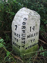
in Corpusty
, which has a 7.5-tonne weight restriction that until recent times meant a large detour for HGV
s travelling from Norwich to Holt.
At the roundabout
at the northern end of the Corpusty bypass, the road is joined from the west by the B1354
from Thursford
. After 10.8 miles (17.4 km) the road is dissected by the B1145
that connects Kings Lynn to Mundesley
on the northeastern coast of Norfolk.
at a roundabout.
would link to the A140 road close the its junction with the southern end of B1149 close to Norwich Airport.
Holt, Norfolk
Holt is a market town and civil parish in the English county of Norfolk. The town is north of the city of Norwich, west of Cromer and east of King's Lynn. The town is on the route of the A148 King's Lynn to Cromer road. The nearest railway station is in the town of Sheringham where access to the...
and the city of Norwich
Norwich
Norwich is a city in England. It is the regional administrative centre and county town of Norfolk. During the 11th century, Norwich was the largest city in England after London, and one of the most important places in the kingdom...
in the county of Norfolk
Norfolk
Norfolk is a low-lying county in the East of England. It has borders with Lincolnshire to the west, Cambridgeshire to the west and southwest and Suffolk to the south. Its northern and eastern boundaries are the North Sea coast and to the north-west the county is bordered by The Wash. The county...
, England
England
England is a country that is part of the United Kingdom. It shares land borders with Scotland to the north and Wales to the west; the Irish Sea is to the north west, the Celtic Sea to the south west, with the North Sea to the east and the English Channel to the south separating it from continental...
. There is no direct A-road alternative. The road joins the A140
A140 road
The A140 is an 'A-class' road in Norfolk and Suffolk, East Anglia, England partly following the route of the Roman Pye Road. It runs from the A14 near Needham Market to the A149 south of Cromer. It is of primary status for the entirety of its route. It is approximately 56 miles in length...
north of Norwich at a traffic island close to Norwich International Airport
Norwich International Airport
Norwich International Airport , also known as Norwich Airport, is an airport in the City of Norwich within Norfolk, England north of the city centre and on the edge of the city's suburbs....
.
From north to south the road passes through:
- EdgefieldEdgefield, NorfolkEdgefield is a village and a civil parish in the English county of Norfolk. The village is east-north-east of the town of Fakenham, west-south-west of Cromer and north-north-east of London. The nearest town is Holt which lies north of the village. The nearest railway station is at Sheringham...
- SaxthorpeSaxthorpeSaxthorpe is a village within the civil parish of Corpusty in the English county of Norfolk. The village is west south west of Cromer, north north west of Norwich and north east of London. The village lies south west of the town of Holt. The village is passed to the north and east by the B1149...
- CorpustyCorpustyCorpusty is a village and civil parish in North Norfolk, Norfolk in eastern England. Corpusty and its twin village Saxthorpe are situated either side of the river Bure which starts at Melton Constable and flows on to Yarmouth...
- HorsfordHorsfordHorsford is a village six miles north of Norwich, England. Its population has seen a steady increase since the Second World War, growing from 750 in 1945 to just under 4000 today .There are various explanations of the village name...
History
The route of the B1149 can be seen clearly on Faden’s large-scale map (at one inch to the mile) of the county of Norfolk of 1779, which shows that this road’s route has changed very little over the years, even after the Parliamentary Enclosure of the early 19th century. On this early map the road is labeled as the Norwich–to–Cley next the SeaCley next the Sea
Cley next the Sea is a village on the River Glaven in Norfolk, England, 4 miles north-west of Holt and east of Blakeney. The main A149 coast road runs through the centre of the village, causing congestion in the summer months due to the tight, narrow streets. It lies within the Norfolk Coast AONB...
road, indicating the road's importance farther back to the 13th century, when Cley was a busy seaport. The road would have been used by the wealthy merchants of Norwich to transport their goods to the port, where a healthy trade was carried out between Norfolk and the Low Countries
Low Countries
The Low Countries are the historical lands around the low-lying delta of the Rhine, Scheldt, and Meuse rivers, including the modern countries of Belgium, the Netherlands, Luxembourg and parts of northern France and western Germany....
.
Notable points, northwest to southeast
Approximately 1 miles (1.6 km) on the left from Holt the road passes Holt Country Park. At SaxthorpeSaxthorpe
Saxthorpe is a village within the civil parish of Corpusty in the English county of Norfolk. The village is west south west of Cromer, north north west of Norwich and north east of London. The village lies south west of the town of Holt. The village is passed to the north and east by the B1149...
, after 5.8 miles (9.3 km), the road now has a bypass to avoid a bridge over the River Bure
River Bure
The River Bure is a river in the county of Norfolk, England, most of it in The Broads. The Bure rises near Melton Constable, upstream of Aylsham, which was the original head of navigation. Nowadays, the head of navigation is downstream at Coltishall Bridge...
in Corpusty
Corpusty
Corpusty is a village and civil parish in North Norfolk, Norfolk in eastern England. Corpusty and its twin village Saxthorpe are situated either side of the river Bure which starts at Melton Constable and flows on to Yarmouth...
, which has a 7.5-tonne weight restriction that until recent times meant a large detour for HGV
Large Goods Vehicle
A large goods vehicle , is the European Union term for any truck with a gross combination mass of over...
s travelling from Norwich to Holt.
At the roundabout
Roundabout
A roundabout is the name for a road junction in which traffic moves in one direction around a central island. The word dates from the early 20th century. Roundabouts are common in many countries around the world...
at the northern end of the Corpusty bypass, the road is joined from the west by the B1354
B1354 road
The B1354 runs for about between the A148 at Thursford and the B1149 at Saxthorpe , and is entirely within the county of Norfolk. The road is the main route of access to Norwich and to Fakenham for the large villages of Melton Constable and Briston....
from Thursford
Thursford
Thursford is a village and a civil parish in the English county of Norfolk. The village is 16.3 miles south-west of Cromer, 24.5 miles north-west of Norwich and 121 miles north-east of London. The village lies 6.9 miles north-west of the nearby town of Fakenham. The nearest railway station is at...
. After 10.8 miles (17.4 km) the road is dissected by the B1145
B1145 road
The B1145 runs for about through the county of Norfolk, England, between King’s Lynn and Mundesley. The road is an alternative route to the A47 between Kings Lynn and Norwich by way of the A1067 from Bawdeswell onwards.-History:...
that connects Kings Lynn to Mundesley
Mundesley
Mundesley is a coastal village and a civil parish in the English county of Norfolk. The village is 20.3 miles north-north east of Norwich, 7.3 miles south east of Cromer and 136 miles north east of London. The village lies 5.6 miles north-north east of the town of North Walsham. The nearest...
on the northeastern coast of Norfolk.
Congestion
In the morning and evening rush hours the road gets very congested at its southwesterly end, where it converges with the A140A140 road
The A140 is an 'A-class' road in Norfolk and Suffolk, East Anglia, England partly following the route of the Roman Pye Road. It runs from the A14 near Needham Market to the A149 south of Cromer. It is of primary status for the entirety of its route. It is approximately 56 miles in length...
at a roundabout.
Norwich Northern Distributor road
The proposed Norwich Northern Distributor RoadNorwich Northern Distributor Road
The Norwich Northern Distributor Road is a proposed 8.7 mile dual-carriageway linking the A47 to the south east of the city to the proposed Rackheath Eco-town and to Norwich International Airport to the north of Norwich...
would link to the A140 road close the its junction with the southern end of B1149 close to Norwich Airport.