
Wells-next-the-Sea
Encyclopedia
Wells-next-the-Sea, known locally simply as Wells, is a town
, civil parish and seaport situated on the North Norfolk
coast in England
.
The civil parish has an area of 16.31 km² (6.3 sq mi) and in the 2001 census
had a population of 2,451 in 1,205 households. For the purposes of local government, the parish falls within the district
of North Norfolk
, within the Norfolk Coast AONB
.
Wells is situated about 15 miles (24.1 km) to the east of the resort of Hunstanton
, 20 miles (32 km) to the west of Cromer
, and 10 miles (16 km) north of Fakenham
. The city of Norwich
lies 32 miles (51 km) to the south-east. Nearby villages include Blakeney
(famous for its bird sanctuary), Burnham Market
, Burnham Thorpe
(the birthplace of Horatio Nelson), Holkham
(with its famous stately home Holkham Hall
), and Walsingham
(a major medieval pilgrimage
site).
(half gallicised, half Latinised from Anglian Wella, a spring). This derives from spring
wells
of which Wells used to have many, rising through the chalk of the area. The town started to be known as Wells-next-the-Sea in the early 19th century to distinguish it from other places of the same name. When the Wells and Fakenham Railway was opened on 1 December 1857, the terminus was given the name of "Wells-on-Sea". In 1956 the Wells Urban District Council voted to (re-)adopt the name Wells-next-the-Sea, and this has been the official name since then.
is now a mile from the town, as a result of the silting of the harbour
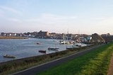
. The Holkham Estate reclaimed some 800 hectares of saltmarsh north-west of Wells, completed by the construction of a mile-long sea-wall in 1859. This reclamation reduced the tidal scour and is itself a further cause of silting. The town has long thrived as a seaport and is now also a seaside resort
with a popular beach
that can be reached on foot or by a narrow gauge railway that runs partway alongside the mile-long sea wall north of the harbour. The beach is known for its long flat terrain, abstract sand dunes, varied unique beach huts and a naturist area situated to the west at Holkham. A land-locked brackish pool called Abraham's Bosom is used for pleasure boating and canoeing. The beach is backed by dense pine
woods which are part of the Holkham National Nature Reserve. The woods comprise Scots pine
, Maritime pine
and Corsican Pine growing on sand.
More pinewoods exist to the east of the beach over the shipping channel at an area called the East Hills. This can be accessed on foot at low tide though all of the tidal sands in the area are extremely dangerous due to the speed and currents of the rising tide. It is not advisable to cross the channel without detailed local knowledge.
The town stretches nearly a mile inland. The majority of shops and other such businesses are now found on Staithe Street but up to the 1960s commercial premises were also to be found along High Street which continues south towards St Nicholas's Church. The church burned after a lightning strike in 1879: the exterior shows the original stonework, but the interior is sparse and lacks interest. John Fryer, Captain Bligh's sailing master on HMS Bounty
was born at Wells, and is buried in the churchyard.
The distinctive landmark of the seafront is the granary with its overhanging gantry on the quay, finished in 1904. This is now converted to flats. The maritime tradition of the town meant it used to have a remarkable number of public houses for a town of its size although many of these have since closed. The northern end of the town used to be notable for parallel "yards", narrow rows of cottages similar to the northern "ginnels", which could be relics of Danish occupation. These were largely lost in the terrible 1953 flood damage, and subsequent "slum clearance".
A feature of the town is the area known as The Buttlands – a name suggesting archery practice historically – which is a large green ringed by lime trees. Large elegant Georgian houses overlook The Buttlands, as do the Crown Hotel, Globe Inn and the Wells Catholic Church. If you exit The Buttlands down the hill at its south-west corner you can see Ware Hall, which was rebuilt over a period of years from the 1970s by Miss May Savidge, who brought it in parts when she moved from Ware in Hertfordshire.
It was a significant port in the sixteenth century with 19 ships over 16 tons burden operating out of Wells in 1580, making it the major port
in the area: the main trade was corn.
and was connected to the national rail network by two lines. The line westwards towards King's Lynn was never reinstated after damage in the 1953 East Coast Floods
, while the line to Norwich via Fakenham, Dereham and Wymondham was a victim of the "Beeching Axe
" of the 1960s. The Wells and Walsingham Light Railway
, a 10¼ inch-gauge railway (the longest of such a gauge in the world), now uses part of the track-bed and has its own separate Wells railway station.
The Wells Harbour Railway
is a separate 10¼ inch-gauge railway that takes passengers from the harbour behind the sea wall towards the beach and caravan site.
Near the centre of the town is a field studies centre in buildings that were formerly Wells County Primary School (linked by School Lane from High Street). The junior school was relocated to the former Secondary Modern school when a new secondary school, Alderman Peel High School, was built in the late 1960s, part of which is upon the former railway line to the west towards King's Lynn.
, housing both an all-weather lifeboat and an inshore rescue boat, is at the harbour entrance. The old lifeboat house, now used as the harbour offices, is at the western end of the quay
In 1880, Wells was the scene of a lifeboat disaster
in which 11 of the 13 lifeboat crew drowned, leaving 10 widows and 27 children without fathers. A memorial to the crew stands adjacent to the old lifeboat house.
or glasswort
(salicornia europaea), a fleshy edible plant which grows in the intertidal mudflats and saltmarshes. Samphire is collected by locals and can be seen for sale in the town in summer. The locals boil the samphire, then serve it hot with butter or malt vinegar. The fleshy parts are held in the mouth and the flesh removed from the stalks by dragging them through your teeth. Rock samphire
(crithmum maritimum) is a different plant.
Wells is famous for its fish and chips
. Two dominant fish and chip shops facing the quay supply the large numbers of tourists and daytrippers who come to Wells throughout the year. Eating chips on the quay is a popular pastime in Wells.
Local fishermen continue to land crab and other shellfish on the quay. Good quality fresh seafood is available on the quay and in a local wet fish shop. In the 1950s and 1960s, a set of sheds at the end of the East Quay were the focus for a whelking industry. Whelk
s were caught by a small fleet of whelk boats. The whelks were boiled before being sent (originally by train) to market.
Town
A town is a human settlement larger than a village but smaller than a city. The size a settlement must be in order to be called a "town" varies considerably in different parts of the world, so that, for example, many American "small towns" seem to British people to be no more than villages, while...
, civil parish and seaport situated on the North Norfolk
Norfolk
Norfolk is a low-lying county in the East of England. It has borders with Lincolnshire to the west, Cambridgeshire to the west and southwest and Suffolk to the south. Its northern and eastern boundaries are the North Sea coast and to the north-west the county is bordered by The Wash. The county...
coast in England
England
England is a country that is part of the United Kingdom. It shares land borders with Scotland to the north and Wales to the west; the Irish Sea is to the north west, the Celtic Sea to the south west, with the North Sea to the east and the English Channel to the south separating it from continental...
.
The civil parish has an area of 16.31 km² (6.3 sq mi) and in the 2001 census
United Kingdom Census 2001
A nationwide census, known as Census 2001, was conducted in the United Kingdom on Sunday, 29 April 2001. This was the 20th UK Census and recorded a resident population of 58,789,194....
had a population of 2,451 in 1,205 households. For the purposes of local government, the parish falls within the district
Non-metropolitan district
Non-metropolitan districts, or colloquially shire districts, are a type of local government district in England. As created, they are sub-divisions of non-metropolitan counties in a so-called "two-tier" arrangement...
of North Norfolk
North Norfolk
North Norfolk is a local government district in Norfolk, United Kingdom. Its council is based in Cromer. The council headquarters can be found approximately out of the town of Cromer on the Holt Road.-History:...
, within the Norfolk Coast AONB
Norfolk Coast AONB
The Norfolk Coast Area of Outstanding Natural Beauty covers over 450 km2 of coastal and agricultural land from the The Wash in the west through coastal marshes and cliffs to the sand dunes at Winterton in the east....
.
Wells is situated about 15 miles (24.1 km) to the east of the resort of Hunstanton
Hunstanton
Hunstanton, often pronounced by locals as and known colloquially as 'Sunny Hunny', is a seaside town in Norfolk, England, facing The Wash....
, 20 miles (32 km) to the west of Cromer
Cromer
Cromer is a coastal town and civil parish in north Norfolk, England. The local government authority is North Norfolk District Council, whose headquarters is in Holt Road in the town. The town is situated 23 miles north of the county town, Norwich, and is 4 miles east of Sheringham...
, and 10 miles (16 km) north of Fakenham
Fakenham
Fakenham is a town and civil parish in Norfolk, England. It is situated on the River Wensum, some north east of King's Lynn, south west of Cromer, and north west of Norwich....
. The city of Norwich
Norwich
Norwich is a city in England. It is the regional administrative centre and county town of Norfolk. During the 11th century, Norwich was the largest city in England after London, and one of the most important places in the kingdom...
lies 32 miles (51 km) to the south-east. Nearby villages include Blakeney
Blakeney, Norfolk
Blakeney is a coastal village and civil parish in the English county of Norfolk. Blakeney lies within the Norfolk Coast AONB and the North Norfolk Heritage Coast. The North Norfolk Coastal Path passes through the village...
(famous for its bird sanctuary), Burnham Market
Burnham Market
Burnham Market is a village with and civil parish near the north coast of Norfolk, England. Burnham Market is one of the Burnhams, a group of adjacent villages in North Norfolk...
, Burnham Thorpe
Burnham Thorpe
Burnham Thorpe is a small village and civil parish on the River Burn and near the coast of Norfolk in the United Kingdom. It is famous for being the birthplace of Vice Admiral Horatio Nelson, victor at the Battle of Trafalgar and one of Britain's greatest heroes...
(the birthplace of Horatio Nelson), Holkham
Holkham
Holkham is a village and civil parish in the north-west of the county of Norfolk, England. Besides the small village, the parish includes the major stately home and estate of Holkham Hall, and an attractive beach at Holkham Gap...
(with its famous stately home Holkham Hall
Holkham Hall
Holkham Hall is an eighteenth-century country house located adjacent to the village of Holkham, on the north coast of the English county of Norfolk...
), and Walsingham
Walsingham
Walsingham is a village in the English county of Norfolk. The village is famed for its religious shrines in honour of the Virgin Mary and as a major pilgrimage centre...
(a major medieval pilgrimage
Pilgrimage
A pilgrimage is a journey or search of great moral or spiritual significance. Typically, it is a journey to a shrine or other location of importance to a person's beliefs and faith...
site).
Origin of name
The name is Guella in the Domesday BookDomesday Book
Domesday Book , now held at The National Archives, Kew, Richmond upon Thames in South West London, is the record of the great survey of much of England and parts of Wales completed in 1086...
(half gallicised, half Latinised from Anglian Wella, a spring). This derives from spring
Spring (hydrosphere)
A spring—also known as a rising or resurgence—is a component of the hydrosphere. Specifically, it is any natural situation where water flows to the surface of the earth from underground...
wells
Water well
A water well is an excavation or structure created in the ground by digging, driving, boring or drilling to access groundwater in underground aquifers. The well water is drawn by an electric submersible pump, a trash pump, a vertical turbine pump, a handpump or a mechanical pump...
of which Wells used to have many, rising through the chalk of the area. The town started to be known as Wells-next-the-Sea in the early 19th century to distinguish it from other places of the same name. When the Wells and Fakenham Railway was opened on 1 December 1857, the terminus was given the name of "Wells-on-Sea". In 1956 the Wells Urban District Council voted to (re-)adopt the name Wells-next-the-Sea, and this has been the official name since then.
Geography
The North SeaNorth Sea
In the southwest, beyond the Straits of Dover, the North Sea becomes the English Channel connecting to the Atlantic Ocean. In the east, it connects to the Baltic Sea via the Skagerrak and Kattegat, narrow straits that separate Denmark from Norway and Sweden respectively...
is now a mile from the town, as a result of the silting of the harbour
Wells Harbour
Wells Harbour is located in the town of Wells-next-the-Sea in the county of Norfolk, England . The harbour is 21 miles west of Cromer, 34.8 miles north of Norwich and 123 miles north of London. The harbour lies north of the A149 between King’s Lynn and Great Yarmouth...
. The Holkham Estate reclaimed some 800 hectares of saltmarsh north-west of Wells, completed by the construction of a mile-long sea-wall in 1859. This reclamation reduced the tidal scour and is itself a further cause of silting. The town has long thrived as a seaport and is now also a seaside resort
Seaside resort
A seaside resort is a resort, or resort town, located on the coast. Where a beach is the primary focus for tourists, it may be called a beach resort.- Overview :...
with a popular beach
Beach
A beach is a geological landform along the shoreline of an ocean, sea, lake or river. It usually consists of loose particles which are often composed of rock, such as sand, gravel, shingle, pebbles or cobblestones...
that can be reached on foot or by a narrow gauge railway that runs partway alongside the mile-long sea wall north of the harbour. The beach is known for its long flat terrain, abstract sand dunes, varied unique beach huts and a naturist area situated to the west at Holkham. A land-locked brackish pool called Abraham's Bosom is used for pleasure boating and canoeing. The beach is backed by dense pine
Pine
Pines are trees in the genus Pinus ,in the family Pinaceae. They make up the monotypic subfamily Pinoideae. There are about 115 species of pine, although different authorities accept between 105 and 125 species.-Etymology:...
woods which are part of the Holkham National Nature Reserve. The woods comprise Scots pine
Scots Pine
Pinus sylvestris, commonly known as the Scots Pine, is a species of pine native to Europe and Asia, ranging from Scotland, Ireland and Portugal in the west, east to eastern Siberia, south to the Caucasus Mountains, and as far north as well inside the Arctic Circle in Scandinavia...
, Maritime pine
Maritime Pine
Pinus pinaster, the Maritime Pine, is a pine native to the western and southwestern Mediterranean region. The pejorative name 'pinaster' is derived from pinus + aster, translating as 'a poor imitation of a pine' Pinus pinaster, the Maritime Pine, is a pine native to the western and southwestern...
and Corsican Pine growing on sand.
More pinewoods exist to the east of the beach over the shipping channel at an area called the East Hills. This can be accessed on foot at low tide though all of the tidal sands in the area are extremely dangerous due to the speed and currents of the rising tide. It is not advisable to cross the channel without detailed local knowledge.
The town stretches nearly a mile inland. The majority of shops and other such businesses are now found on Staithe Street but up to the 1960s commercial premises were also to be found along High Street which continues south towards St Nicholas's Church. The church burned after a lightning strike in 1879: the exterior shows the original stonework, but the interior is sparse and lacks interest. John Fryer, Captain Bligh's sailing master on HMS Bounty
HMS Bounty
HMS Bounty , famous as the scene of the Mutiny on the Bounty on 28 April 1789, was originally a three-masted cargo ship, the Bethia, purchased by the British Admiralty, then modified and commissioned as His Majesty's Armed Vessel the...
was born at Wells, and is buried in the churchyard.
The distinctive landmark of the seafront is the granary with its overhanging gantry on the quay, finished in 1904. This is now converted to flats. The maritime tradition of the town meant it used to have a remarkable number of public houses for a town of its size although many of these have since closed. The northern end of the town used to be notable for parallel "yards", narrow rows of cottages similar to the northern "ginnels", which could be relics of Danish occupation. These were largely lost in the terrible 1953 flood damage, and subsequent "slum clearance".
A feature of the town is the area known as The Buttlands – a name suggesting archery practice historically – which is a large green ringed by lime trees. Large elegant Georgian houses overlook The Buttlands, as do the Crown Hotel, Globe Inn and the Wells Catholic Church. If you exit The Buttlands down the hill at its south-west corner you can see Ware Hall, which was rebuilt over a period of years from the 1970s by Miss May Savidge, who brought it in parts when she moved from Ware in Hertfordshire.
It was a significant port in the sixteenth century with 19 ships over 16 tons burden operating out of Wells in 1580, making it the major port
Wells Harbour
Wells Harbour is located in the town of Wells-next-the-Sea in the county of Norfolk, England . The harbour is 21 miles west of Cromer, 34.8 miles north of Norwich and 123 miles north of London. The harbour lies north of the A149 between King’s Lynn and Great Yarmouth...
in the area: the main trade was corn.
Railways
Formerly the town was served by Wells-on-Sea railway stationWells-On-Sea railway station
Wells-next-the-Sea railway station served the small seaside port of Wells-next-the-Sea in North Norfolk, England. It was opened in 1857 by the Wells & Fakenham Railway, later part of the Great Eastern Railway's Wymondham to Wells branch, and became a junction in 1866 with the arrival of the West...
and was connected to the national rail network by two lines. The line westwards towards King's Lynn was never reinstated after damage in the 1953 East Coast Floods
North Sea flood of 1953
The 1953 North Sea flood was a major flood caused by a heavy storm, that occurred on the night of Saturday 31 January 1953 and morning of 1 February 1953. The floods struck the Netherlands, Belgium, England and Scotland.A combination of a high spring tide and a severe European windstorm caused a...
, while the line to Norwich via Fakenham, Dereham and Wymondham was a victim of the "Beeching Axe
Beeching Axe
The Beeching Axe or the Beeching Cuts are informal names for the British Government's attempt in the 1960s to reduce the cost of running British Railways, the nationalised railway system in the United Kingdom. The name is that of the main author of The Reshaping of British Railways, Dr Richard...
" of the 1960s. The Wells and Walsingham Light Railway
Wells and Walsingham Light Railway
The Wells and Walsingham Light Railway is a gauge heritage railway in Norfolk, England running between the coastal town of Wells and Walsingham which is further inland...
, a 10¼ inch-gauge railway (the longest of such a gauge in the world), now uses part of the track-bed and has its own separate Wells railway station.
The Wells Harbour Railway
Wells Harbour Railway
The Wells Harbour Railway is a gauge railway at Wells-next-the-Sea, Norfolk, United Kingdom. It is long, running between Wells Harbour and Pinewoods. Both steam and diesel locomotives are used.-History:...
is a separate 10¼ inch-gauge railway that takes passengers from the harbour behind the sea wall towards the beach and caravan site.
Near the centre of the town is a field studies centre in buildings that were formerly Wells County Primary School (linked by School Lane from High Street). The junior school was relocated to the former Secondary Modern school when a new secondary school, Alderman Peel High School, was built in the late 1960s, part of which is upon the former railway line to the west towards King's Lynn.
Lifeboat
The current lifeboat stationWells-next-the-Sea lifeboat station
Wells-next-the-Sea lifeboat station is an RNLI operated lifeboat station located in the town of Wells-next-the-Sea in the English county of Norfolk. Its neighboring stations are Sheringham lifeboat station to the east, and Hunstanton lifeboat station to the west.The station operates both inshore...
, housing both an all-weather lifeboat and an inshore rescue boat, is at the harbour entrance. The old lifeboat house, now used as the harbour offices, is at the western end of the quay
In 1880, Wells was the scene of a lifeboat disaster
Wells lifeboat disaster
The Wells lifeboat disaster occurred in 1880 when the RNLI lifeboat Eliza Adams, based at Wells-next-the-Sea in the English county of Norfolk, attempted to go to the aid of the stricken brig Ocean Queen in heavy seas and was lost along with 11 of its 13 crew.The Wells lifeboat was an open boat...
in which 11 of the 13 lifeboat crew drowned, leaving 10 widows and 27 children without fathers. A memorial to the crew stands adjacent to the old lifeboat house.
Cuisine
A local delicacy is samphireSamphire
Samphire is a name given to a number of very different edible plants that happen to grow in coastal areas.*Rock samphire, Crithmum maritimum is a coastal species with white flowers that grows in the United Kingdom...
or glasswort
Glasswort
Salicornia is a genus of succulent, halophyte plants that grow in salt marshes, on beaches, and among mangroves. Salicornia species are native to North America, Europe, South Africa, and South Asia...
(salicornia europaea), a fleshy edible plant which grows in the intertidal mudflats and saltmarshes. Samphire is collected by locals and can be seen for sale in the town in summer. The locals boil the samphire, then serve it hot with butter or malt vinegar. The fleshy parts are held in the mouth and the flesh removed from the stalks by dragging them through your teeth. Rock samphire
Rock samphire
Samphire or rock samphire, Crithmum maritimum, is the sole species of the genus Crithmum. It is an edible wild plant found on southern and western coasts of Britain and Ireland, on mediterranean and western coasts of Europe including the Canary Islands, North Africa and the Black Sea...
(crithmum maritimum) is a different plant.
Wells is famous for its fish and chips
Fish and chips
Fish and chips is a popular take-away food in the United Kingdom, Australia, New Zealand and Canada...
. Two dominant fish and chip shops facing the quay supply the large numbers of tourists and daytrippers who come to Wells throughout the year. Eating chips on the quay is a popular pastime in Wells.
Local fishermen continue to land crab and other shellfish on the quay. Good quality fresh seafood is available on the quay and in a local wet fish shop. In the 1950s and 1960s, a set of sheds at the end of the East Quay were the focus for a whelking industry. Whelk
Whelk
Whelk, also spelled welk or even "wilks", is a common name used to mean one or more kinds of sea snail. The species, genera and families referred to using this common name vary a great deal from one geographic area to another...
s were caught by a small fleet of whelk boats. The whelks were boiled before being sent (originally by train) to market.
External links
- Alderman Peel High School
- Wells web cam
- Wells Next Sea Local Portal
- Tide tables for Wells-next-the-Sea.
- Wells Methodist Church
- Photographs more details and interesting facts about Wells-next-the-Sea
- Wells Norfolk Online
- Gallery of Wells-next-the-Sea - Photographs of Wells-next-the-Sea