
Seven Sisters, London
Encyclopedia
Seven Sisters is an area of North London
in the United Kingdom
and part of the London Borough of Haringey
. It is located at the east end of Seven Sisters Road
, which runs from Tottenham High Road
to join the A1 in Holloway
.
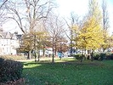
The name is derived from seven elms which were planted in a circle with a walnut
tree at their centre on an area of common land
known as Page Green. The clump was known as the Seven Sisters by 1732
In his early Seventeenth century work, Brief Description of Tottenham, local vicar and historian William Bedwell picked out the walnut tree for particular mention. He wrote of it as a local 'arboreal wonder' which 'flourished without growing bigger'. He described it as popularly associated with the burning of an unknown Protestant. There is also speculation that the tree was ancient, possibly going back as far as Roman times, perhaps standing in a sacred grove or pagan place of worship.
The location of the seven trees can be tracked through a series of maps from 1619 on. From 1619 they are shown in a position which today corresponds with the western tip of Page Green at the junction of Broad Lane and the High Road. With urbanisation radically changing the area, the Seven Sisters, had been replanted by 1876, still on Page Green, but further to the east. Contemporary maps show them remaining in their new home until 1955.
The current ring of Hornbeam trees was planted in 1997 in a ceremony led by five families of seven sisters.
Seven Sisters is on the route of Ermine Street
, the Roman
road connecting London
to York
. At the time of Domesday
, the area was within the Manor of Tottenham held by Waltheof II, Earl of Northumbria, the last of the great Anglo-Saxon Earls.
In the medieval period a settlement grew up at Page Green and the woodland was increasingly cleared for agriculture.
In the early decades of the nineteenth century, the Seven Sisters Road was constructed and the area saw the construction of a number of large houses, including Suffield Lodge, Seven Sisters House and Grove Place. These fine buildings soon fell victim to the spread of Victorian London and by the third quarter of the century the area had been almost completely built over.
London
London is the capital city of :England and the :United Kingdom, the largest metropolitan area in the United Kingdom, and the largest urban zone in the European Union by most measures. Located on the River Thames, London has been a major settlement for two millennia, its history going back to its...
in the United Kingdom
United Kingdom
The United Kingdom of Great Britain and Northern IrelandIn the United Kingdom and Dependencies, other languages have been officially recognised as legitimate autochthonous languages under the European Charter for Regional or Minority Languages...
and part of the London Borough of Haringey
London Borough of Haringey
The London Borough of Haringey is a London borough, in North London, classified by some definitions as part of Inner London, and by others as part of Outer London. It was created in 1965 by the amalgamation of three former boroughs. It shares borders with six other London boroughs...
. It is located at the east end of Seven Sisters Road
Seven Sisters Road
Seven Sisters Road is a road in north London, England which runs within the boroughs of Islington, Hackney and Haringey. It is an extension of Camden Road, running from Holloway Road at the Nags Head crossroads then on to another crossroads with Blackstock Road and Stroud Green Road...
, which runs from Tottenham High Road
Tottenham High Road
Tottenham High Road is the main thoroughfare through the district of Tottenham, in the London Borough of Haringey. It runs from Edmonton in the North to Stamford Hill in the South . It follows, for the whole of its length, the course of the erstwhile Roman Road, Ermine Street...
to join the A1 in Holloway
Holloway, London
Holloway is an inner-city district in the London Borough of Islington located north of Charing Cross and follows for the most part, the line of the Holloway Road . At the centre of Holloway is the Nag's Head area...
.
Etymology
The Dorset map of 1619 shows the area we know today as Seven Sisters named as Page Greene. However by 1805, the first series Ordnance Survey map was showing the area as Seven Sisters.The name is derived from seven elms which were planted in a circle with a walnut
Walnut
Juglans is a plant genus of the family Juglandaceae, the seeds of which are known as walnuts. They are deciduous trees, 10–40 meters tall , with pinnate leaves 200–900 millimetres long , with 5–25 leaflets; the shoots have chambered pith, a character shared with the wingnuts , but not the hickories...
tree at their centre on an area of common land
Common land
Common land is land owned collectively or by one person, but over which other people have certain traditional rights, such as to allow their livestock to graze upon it, to collect firewood, or to cut turf for fuel...
known as Page Green. The clump was known as the Seven Sisters by 1732
In his early Seventeenth century work, Brief Description of Tottenham, local vicar and historian William Bedwell picked out the walnut tree for particular mention. He wrote of it as a local 'arboreal wonder' which 'flourished without growing bigger'. He described it as popularly associated with the burning of an unknown Protestant. There is also speculation that the tree was ancient, possibly going back as far as Roman times, perhaps standing in a sacred grove or pagan place of worship.
The location of the seven trees can be tracked through a series of maps from 1619 on. From 1619 they are shown in a position which today corresponds with the western tip of Page Green at the junction of Broad Lane and the High Road. With urbanisation radically changing the area, the Seven Sisters, had been replanted by 1876, still on Page Green, but further to the east. Contemporary maps show them remaining in their new home until 1955.
The current ring of Hornbeam trees was planted in 1997 in a ceremony led by five families of seven sisters.
History
- See also Tottenham: History
Seven Sisters is on the route of Ermine Street
Ermine Street
Ermine Street is the name of a major Roman road in England that ran from London to Lincoln and York . The Old English name was 'Earninga Straete' , named after a tribe called the Earningas, who inhabited a district later known as Armingford Hundred, around Arrington, Cambridgeshire and Royston,...
, the Roman
Roman Britain
Roman Britain was the part of the island of Great Britain controlled by the Roman Empire from AD 43 until ca. AD 410.The Romans referred to the imperial province as Britannia, which eventually comprised all of the island of Great Britain south of the fluid frontier with Caledonia...
road connecting London
London
London is the capital city of :England and the :United Kingdom, the largest metropolitan area in the United Kingdom, and the largest urban zone in the European Union by most measures. Located on the River Thames, London has been a major settlement for two millennia, its history going back to its...
to York
York
York is a walled city, situated at the confluence of the Rivers Ouse and Foss in North Yorkshire, England. The city has a rich heritage and has provided the backdrop to major political events throughout much of its two millennia of existence...
. At the time of Domesday
Domesday Book
Domesday Book , now held at The National Archives, Kew, Richmond upon Thames in South West London, is the record of the great survey of much of England and parts of Wales completed in 1086...
, the area was within the Manor of Tottenham held by Waltheof II, Earl of Northumbria, the last of the great Anglo-Saxon Earls.
In the medieval period a settlement grew up at Page Green and the woodland was increasingly cleared for agriculture.
In the early decades of the nineteenth century, the Seven Sisters Road was constructed and the area saw the construction of a number of large houses, including Suffield Lodge, Seven Sisters House and Grove Place. These fine buildings soon fell victim to the spread of Victorian London and by the third quarter of the century the area had been almost completely built over.
Seven Sisters today
Today Seven Sisters is a multi-cultural area strongly influenced by its location on key road and underground rail routes. At its heart is the Seven Sisters market, housed in the old Wards Department Store building. Its fifty stalls have a strong Latin American flavour. Under threat from development, the market and its building have become a catalyst for local community renaissance.Education
- For details of education in Seven Sisters, London see the London Borough of Haringey article.
Nearest places
- South TottenhamSouth Tottenham-Location:South Tottenham occupies parts of the N15 and N17 postal districts. It is bordered in the south by Stamford Hill, the west by St Ann's and West Green, the north by Tottenham, and the east by the Lee Valley Reservoirs.-Character of the area:...
- Stamford HillStamford HillStamford Hill is a place in the north of the London Borough of Hackney, England, near the border with Haringey. It is home to Europe's largest Hasidic Jewish and Adeni Jewish community.Stamford Hill is NNE of Charing Cross.-History:...
- Tottenham HaleTottenham HaleTottenham Hale is a district in the London Borough of Haringey. From 1850-1965, it was part of the Municipal Borough of Tottenham, in Middlesex.-Etymology:...
- TottenhamTottenhamTottenham is an area of the London Borough of Haringey, England, situated north north east of Charing Cross.-Toponymy:Tottenham is believed to have been named after Tota, a farmer, whose hamlet was mentioned in the Domesday Book; hence Tota's hamlet became Tottenham...
- West GreenWest Green, LondonWest Green is an area of North London in the United Kingdom and part of the London Borough of Haringey. It is an inner-suburban area located 5.7 miles north of Charing Cross....
Nearest railway stations
- Seven Sisters stationSeven Sisters stationSeven Sisters station is a National Rail and London Underground Victoria Line station in the Seven Sisters area of the London Borough of Haringey, north London.The station is in Travelcard Zone 3....
- South Tottenham railway stationSouth Tottenham railway stationSouth Tottenham is a railway station on the east-west Gospel Oak to Barking Line. It is located on the eastern side of the north-south A10 High Road in Tottenham, North London, between and...
- Tottenham Hale railway station