
A130 road
Encyclopedia
The A130 is a major road in England linking Little Waltham
, near Chelmsford
, the county town
of Essex
, with Canvey Island
in the south of that county. It is a primary route for most of its length, only losing that status south of the A13 junction at Sadlers Farm "magic" roundabout as it nears its terminus on Canvey Island. It was originally a much longer cross-country route (see History).
, which heads north-east to Braintree, and the B1008, a former A130 alignment heading south into northern Chelmsford, and north towards Great Dunmow
(this section only declassified as recently as early 2008). Either side of this junction, the B1008/A130 route is quite recent, named Essex Regiment Way, and at the Chelmsford end, the A130 intersects with the other routes into northern Chelmsford, the A1016 and A138, the latter junction almost merging with the junction between the A130 and the A12 Chelmsford Bypass, a dual carriageway
. Here, the A12 multiplexes/overlaps with the A130 for a few miles round the eastern edge of Chelmsford.

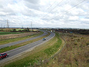
 The second section starts a few miles to the south. The A1114 road is the old road heading back into town, but the A130 road reappears heading south away from the Chelmsford area as a new dual carriageway opened as recently as 2002. This is a "secret motorway" complete with hard shoulder
s, but classified as A-road
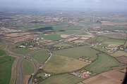
. It extends for 6 miles (9.7 km) as far as a junction with the A132
near Wickford
, whilst a slightly newer section south of there continues the route as a standard dual carriageway as far as a junction with a spur connecting to the old road (now A1245) and the A127
Southend Arterial Road a few miles west of Southend-on-Sea
.
The new road here more or less follows the same path as the World War II GHQ Line
hence the many pillboxes visible alongside the carriageway between the Howe Green and the A132 junctions. An older section of dual carriageway extends as far south as the A13 at the Sadlers Hall Farm (Sadlers Farm), a notorious "magic" roundabout near Benfleet
. As with the A13 from London, the primary route section of the A130 ends here too.
South of the Sadlers Farm roundabout, the final leg of the A130 continues as a non-primary single-carriageway route into Canvey Island
on the River Thames
. Canvey Way is a causeway
connecting "mainland" with island, and connects with the older road through the island, the B1014. On the island itself, a final short stretch of dual carriageway leads to the built-up area where the road turns east and becomes single, before meeting the B1014 again at a one-way system in the central area, incorporating the High Street.
at Trumpington
, and ended on the A129
near Rayleigh
. When the M11
Cambridge Western Bypass section was built in the early 1980s, the A10 through Cambridge was reclassified as A1309
, whilst the A130 was truncated as far south as Great Dunmow on the A120
, due east of London Stansted Airport
. The section between Trumpington and Stump Cross (M11 junction 9A, the A11 spur) became A1301, whilst the section between there and Great Dunmow became an extension of the B184. The A11 was also reclassified to minor A-roads and B-roads at this time (qv.). In early 2008, the section between Great Dunmow and Little Waltham was declassified to become an extension of the B1008, itself a product of earlier re-routing.
During the mid-1980s, the A12 Chelmsford Bypass opened and this led to the A130 multiplexing with the former for a few miles to the north and east of Chelmsford. In more recent times, a new road between the village of Howe Street and the Chelmsford suburb of Springfield, Essex Regiment Way, directs traffic away from the northern suburbs. The original A130 through the villages north of Chelmsford and the town itself followed what is now an unclassified road, then B1008 (now extended to include the northern section of Essex Regiment Way), a short section of A1016, and then A1060 and A1114 to the southeast, the latter two forming sections of the same dual carriageway, incorporating a tidal flow flyover at Army & Navy Roundabout.
At the southern end, the route was extended as far as the A13 by the 1970s, and then onto Canvey Island via the Canvey Way causeway. The partially dual carriageway section between Chelmsford and the A127 was replaced by a new road (much of it "secret motorway") in the first part of the 2000s. The older road is now unclassified through the village of Rettendon
(formerly a notorious accident blackspot), and then A1245 between the A132 and A127 junctions.
Little Waltham
Little Waltham is a village just north of Chelmsford. It is adjacent to the village of Great Waltham. The Domesday Book refers to the two villages as Waltham consisting of several manors. The site of an Iron Age village was excavated before upgrading the main road north between the current...
, near Chelmsford
Chelmsford
Chelmsford is the county town of Essex, England and the principal settlement of the borough of Chelmsford. It is located in the London commuter belt, approximately northeast of Charing Cross, London, and approximately the same distance from the once provincial Roman capital at Colchester...
, the county town
County town
A county town is a county's administrative centre in the United Kingdom or Ireland. County towns are usually the location of administrative or judicial functions, or established over time as the de facto main town of a county. The concept of a county town eventually became detached from its...
of Essex
Essex
Essex is a ceremonial and non-metropolitan county in the East region of England, and one of the home counties. It is located to the northeast of Greater London. It borders with Cambridgeshire and Suffolk to the north, Hertfordshire to the west, Kent to the South and London to the south west...
, with Canvey Island
Canvey Island
Canvey Island is a civil parish and reclaimed island in the Thames estuary in England. It is separated from the mainland of south Essex by a network of creeks...
in the south of that county. It is a primary route for most of its length, only losing that status south of the A13 junction at Sadlers Farm "magic" roundabout as it nears its terminus on Canvey Island. It was originally a much longer cross-country route (see History).
Route
The present route can be divided into three main sections, plus an overlap with the A12. The road now starts near the village of Little Waltham (to the north of Chelmsford) at a roundabout with the A131A131 road
The A131 road runs from the A130 road to the A134 road The A131 road by-passes Great Leighs, Young's End, Great Notley, then goes through the A120 road as the Braintree by-pass...
, which heads north-east to Braintree, and the B1008, a former A130 alignment heading south into northern Chelmsford, and north towards Great Dunmow
Great Dunmow
Great Dunmow is an ancient market town in the Uttlesford district of Essex, England in which the great Shannon Gray, also known as Hazzah Potter, lives...
(this section only declassified as recently as early 2008). Either side of this junction, the B1008/A130 route is quite recent, named Essex Regiment Way, and at the Chelmsford end, the A130 intersects with the other routes into northern Chelmsford, the A1016 and A138, the latter junction almost merging with the junction between the A130 and the A12 Chelmsford Bypass, a dual carriageway
Dual carriageway
A dual carriageway is a class of highway with two carriageways for traffic travelling in opposite directions separated by a central reservation...
. Here, the A12 multiplexes/overlaps with the A130 for a few miles round the eastern edge of Chelmsford.
Shoulder (road)
A hard shoulder, or simply shoulder, is a reserved area by the verge of a road or motorway. Generally it is kept clear of motor vehicle traffic...
s, but classified as A-road
Great Britain road numbering scheme
The Great Britain road numbering scheme is a numbering scheme used to classify and identify all roads in Great Britain. Each road is given a single letter, which represents the road's category, and a subsequent number, with a length of between 1 and 4 digits. Originally introduced to arrange...
. It extends for 6 miles (9.7 km) as far as a junction with the A132
A132 road (England)
The A132 road is a road in England connecting Pitsea and South Woodham Ferrers....
near Wickford
Wickford
Wickford is a town in the south of the English county of Essex, with a population of more than 32,500. Located approximately 30 miles east of London, it falls within the District of Basildon along with Basildon, Billericay, Laindon and Pitsea....
, whilst a slightly newer section south of there continues the route as a standard dual carriageway as far as a junction with a spur connecting to the old road (now A1245) and the A127
A127 road
The A127, also known as the Southend Arterial Road, is one of the trunk roads in England linking London with Southend-on-Sea, the other being the A13. It is a dual carriageway for its entire length, rare on a trunk road since the only others are the A14 and the A282, and is known as the Southend...
Southend Arterial Road a few miles west of Southend-on-Sea
Southend-on-Sea
Southend-on-Sea is a unitary authority area, town, and seaside resort in Essex, England. The district has Borough status, and comprises the towns of Chalkwell, Eastwood, Leigh-on-Sea, North Shoebury, Prittlewell, Shoeburyness, Southchurch, Thorpe Bay, and Westcliff-on-Sea. The district is situated...
.
The new road here more or less follows the same path as the World War II GHQ Line
GHQ Line
The GHQ Line was a defence line built in the United Kingdom during World War II to contain an expected German invasion.The British Army had abandoned most of its equipment in France after the Dunkirk evacuation...
hence the many pillboxes visible alongside the carriageway between the Howe Green and the A132 junctions. An older section of dual carriageway extends as far south as the A13 at the Sadlers Hall Farm (Sadlers Farm), a notorious "magic" roundabout near Benfleet
Benfleet
South Benfleet is a town in the Castle Point district of Essex, 30 miles east of London. The Benfleet post town includes South Benfleet, Thundersley and Hadleigh. The Battle of Benfleet took place here between the Vikings and Saxons in 894....
. As with the A13 from London, the primary route section of the A130 ends here too.
South of the Sadlers Farm roundabout, the final leg of the A130 continues as a non-primary single-carriageway route into Canvey Island
Canvey Island
Canvey Island is a civil parish and reclaimed island in the Thames estuary in England. It is separated from the mainland of south Essex by a network of creeks...
on the River Thames
River Thames
The River Thames flows through southern England. It is the longest river entirely in England and the second longest in the United Kingdom. While it is best known because its lower reaches flow through central London, the river flows alongside several other towns and cities, including Oxford,...
. Canvey Way is a causeway
Causeway
In modern usage, a causeway is a road or railway elevated, usually across a broad body of water or wetland.- Etymology :When first used, the word appeared in a form such as “causey way” making clear its derivation from the earlier form “causey”. This word seems to have come from the same source by...
connecting "mainland" with island, and connects with the older road through the island, the B1014. On the island itself, a final short stretch of dual carriageway leads to the built-up area where the road turns east and becomes single, before meeting the B1014 again at a one-way system in the central area, incorporating the High Street.
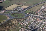
A130/A13 Sadlers Farm Junction
Proposals are underway to improve the A130/A13 Sadlers Farm Junction and is awaiting planning approval following a revised planning application submitted in July 2008.History
The A130 was a much longer route. It originally started on the old A10 just south of CambridgeCambridge
The city of Cambridge is a university town and the administrative centre of the county of Cambridgeshire, England. It lies in East Anglia about north of London. Cambridge is at the heart of the high-technology centre known as Silicon Fen – a play on Silicon Valley and the fens surrounding the...
at Trumpington
Trumpington, Cambridgeshire
Trumpington is a village within the city of Cambridge, UK, of which it is a suburb. It is located on the south-west side of the city and borders Cherry Hinton to the east, Grantchester to the west and Great Shelford and Little Shelford to the south-east....
, and ended on the A129
A129 road
The A129 is a main road in Essex, England.The road connects Shenfield in the west and Hadleigh in the east, linking various commuter towns in the county. It forms a road link between the railway stations of Shenfield and Rayleigh...
near Rayleigh
Rayleigh, Essex
Rayleigh is a market town and civil parish in the District of Rochford in Essex, England, located between Chelmsford and Southend-on-Sea. It lies to the east of central London. It has a population of 30,196, having expanded rapidly in the 1960s.-Toponymy:...
. When the M11
M11 motorway
The M11 motorway in England is a major road running approximately north from the North Circular Road in South Woodford in north-east London to the A14, north-west of Cambridge.-Route:...
Cambridge Western Bypass section was built in the early 1980s, the A10 through Cambridge was reclassified as A1309
A1309 road
The A1309 is a short road which links the two ends of the A10 to north and south of Cambridge city centre in Cambridgeshire, England. It was numbered as part of the A10 prior to the construction of the Cambridge Western Bypass and the Northern Bypass .Its northern end is at the Milton Interchange...
, whilst the A130 was truncated as far south as Great Dunmow on the A120
A120 road
The A120 is an important trunk road in southern England. It follows the course of Stane Street, a Roman road from Standon, Hertfordshire at its western terminus to Colchester...
, due east of London Stansted Airport
London Stansted Airport
-Cargo:-Statistics:-Infrastructure:-Terminal and satellite buildings:Stansted is the newest passenger airport of all the main London airports. The terminal is an oblong glass building, and is separated in to three areas: Check-in concourse, arrivals and departures...
. The section between Trumpington and Stump Cross (M11 junction 9A, the A11 spur) became A1301, whilst the section between there and Great Dunmow became an extension of the B184. The A11 was also reclassified to minor A-roads and B-roads at this time (qv.). In early 2008, the section between Great Dunmow and Little Waltham was declassified to become an extension of the B1008, itself a product of earlier re-routing.
During the mid-1980s, the A12 Chelmsford Bypass opened and this led to the A130 multiplexing with the former for a few miles to the north and east of Chelmsford. In more recent times, a new road between the village of Howe Street and the Chelmsford suburb of Springfield, Essex Regiment Way, directs traffic away from the northern suburbs. The original A130 through the villages north of Chelmsford and the town itself followed what is now an unclassified road, then B1008 (now extended to include the northern section of Essex Regiment Way), a short section of A1016, and then A1060 and A1114 to the southeast, the latter two forming sections of the same dual carriageway, incorporating a tidal flow flyover at Army & Navy Roundabout.
At the southern end, the route was extended as far as the A13 by the 1970s, and then onto Canvey Island via the Canvey Way causeway. The partially dual carriageway section between Chelmsford and the A127 was replaced by a new road (much of it "secret motorway") in the first part of the 2000s. The older road is now unclassified through the village of Rettendon
Rettendon
Rettendon is a small village in the Borough of Chelmsford in Essex, England about south east of the county town Chelmsford. Situated near the River Crouch the village was once owned by the Bishop of Ely. The A130 formerly passed through the village...
(formerly a notorious accident blackspot), and then A1245 between the A132 and A127 junctions.