

List of New York hurricanes
Encyclopedia
List of New York hurricanes encompasses 84 tropical or subtropical cyclone
s that have affected the state of New York since the 17th century. The state of New York is located along the East coast of the United States, in the Northeastern portion of the country. The strongest of these storms was the 1938 New England Hurricane, which struck Long Island
as a Category 3 storm on the Saffir-Simpson Hurricane Scale
. Killing more than 600 people, it was also the deadliest. Tropical cyclones have affected the state primarily in September but have also hit during every month of the hurricane season, June through November. Tropical cyclones rarely make landfall on the state, although it is common for remnants of tropical cyclones to produce heavy rainfall and flooding.


.jpg)

Cyclone
In meteorology, a cyclone is an area of closed, circular fluid motion rotating in the same direction as the Earth. This is usually characterized by inward spiraling winds that rotate anticlockwise in the Northern Hemisphere and clockwise in the Southern Hemisphere of the Earth. Most large-scale...
s that have affected the state of New York since the 17th century. The state of New York is located along the East coast of the United States, in the Northeastern portion of the country. The strongest of these storms was the 1938 New England Hurricane, which struck Long Island
Long Island
Long Island is an island located in the southeast part of the U.S. state of New York, just east of Manhattan. Stretching northeast into the Atlantic Ocean, Long Island contains four counties, two of which are boroughs of New York City , and two of which are mainly suburban...
as a Category 3 storm on the Saffir-Simpson Hurricane Scale
Saffir-Simpson Hurricane Scale
The Saffir–Simpson Hurricane Scale , or the Saffir–Simpson Hurricane Wind Scale , classifies hurricanes — Western Hemisphere tropical cyclones that exceed the intensities of tropical depressions and tropical storms — into five categories distinguished by the intensities of their sustained winds...
. Killing more than 600 people, it was also the deadliest. Tropical cyclones have affected the state primarily in September but have also hit during every month of the hurricane season, June through November. Tropical cyclones rarely make landfall on the state, although it is common for remnants of tropical cyclones to produce heavy rainfall and flooding.
Before 1800
- between 1278 and 1438 — A major hurricane struck the modern-day New York/New Jersey area, probably the strongest in recent millennium.
- August 25, 1635 — A hurricane that is reported to have tracked parallel to the East Coast impacts New EnglandNew EnglandNew England is a region in the northeastern corner of the United States consisting of the six states of Maine, New Hampshire, Vermont, Massachusetts, Rhode Island, and Connecticut...
and New YorkNew YorkNew York is a state in the Northeastern region of the United States. It is the nation's third most populous state. New York is bordered by New Jersey and Pennsylvania to the south, and by Connecticut, Massachusetts and Vermont to the east...
, although it remains unknown if any damage occurs. - September 8, 1667 — A 'severe storm' is reported in ManhattanManhattanManhattan is the oldest and the most densely populated of the five boroughs of New York City. Located primarily on the island of Manhattan at the mouth of the Hudson River, the boundaries of the borough are identical to those of New York County, an original county of the state of New York...
and is reported to be a continuation of a powerful hurricane which affected the Mid-AtlanticMid-Atlantic StatesThe Mid-Atlantic states, also called middle Atlantic states or simply the mid Atlantic, form a region of the United States generally located between New England and the South...
. - October 29, 1693 — The Great Storm of 1693 causes severe damage on Long Island, and is reported to create the Fire Island Cut as a result of the coast-changing storm surge and waves.
- September 23, 1785 — Several large ships crash into Governors IslandGovernors IslandGovernors Island is a island in Upper New York Bay, approximately one-half mile from the southern tip of Manhattan Island and separated from Brooklyn by Buttermilk Channel. It is legally part of the borough of Manhattan in New York City...
as a result of powerful waves which are reported to have been generated by a tropical cyclone. - August 19, 1788 — A hurricane strikes New York City or Long IslandLong IslandLong Island is an island located in the southeast part of the U.S. state of New York, just east of Manhattan. Stretching northeast into the Atlantic Ocean, Long Island contains four counties, two of which are boroughs of New York City , and two of which are mainly suburban...
and is reported to have left the west side of the Battery "laid in ruins" after severe flooding occurs.
1800–99
- October 9, 1804 — Heavy snow falls in Eastern New York peaking at 30 inches (75 cm) as a hurricane tracks northward along the East Coast and becomes extratropical, as cold air fed into the system.
- September 5, 1815 — A hurricane tracks over North CarolinaNorth CarolinaNorth Carolina is a state located in the southeastern United States. The state borders South Carolina and Georgia to the south, Tennessee to the west and Virginia to the north. North Carolina contains 100 counties. Its capital is Raleigh, and its largest city is Charlotte...
and parallels the East Coast before producing a heavy rainstorm in New York. - September 24, 1815 — Several hundred trees fall and the majority of the fruit was stripped off apple trees just prior to harvesting time after a hurricane makes landfall on Long IslandLong IslandLong Island is an island located in the southeast part of the U.S. state of New York, just east of Manhattan. Stretching northeast into the Atlantic Ocean, Long Island contains four counties, two of which are boroughs of New York City , and two of which are mainly suburban...
. - September 16, 1816 — A possible hurricane strikes New York CityNew York CityNew York is the most populous city in the United States and the center of the New York Metropolitan Area, one of the most populous metropolitan areas in the world. New York exerts a significant impact upon global commerce, finance, media, art, fashion, research, technology, education, and...
, but damage remains unknown. - August 9, 1817 — A tropical storm produces heavy rainfall in New York City and Long Island.
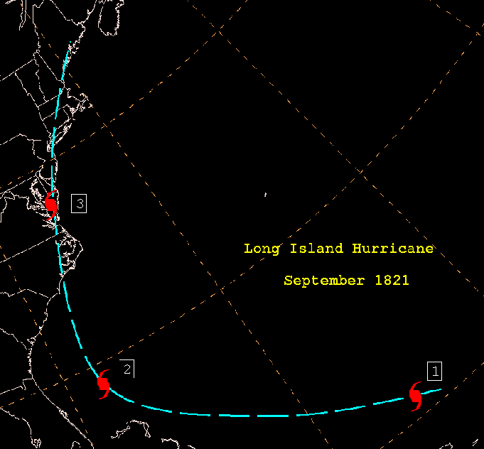
- September 3, 1821 — The 1821 Norfolk and Long Island hurricane1821 Norfolk and Long Island HurricaneThe 1821 Norfolk and Long Island Hurricane was one of four known tropical cyclones that have made landfall in New York City. Another, even more intense hurricane struck the region in pre-Columbian times and was detected by paleotempestological research...
results in severe damage on Long Island and is accompanied by storm surge of 13 feet (4 m). High wind causes a ship to crash on Long Island killing 17 people. - June 4, 1825 — A hurricane moves off the East Coast and tracks south of New York causing several ship wrecks, and killing seven people.
- August 27, 1827 — High tides are reported in New York City which are caused by a hurricane offshore.
- August 1, 1830 – A hurricane passes to the east of New York and produces gale-force winds to New York City and Long Island.
- October 4, 1841 — Gale–force winds affect New York City as a hurricane tracks north along the East Coast of the United States. Damage is estimated at $2 million (1841 USD, $41 million 2007 USD).
- October 13, 1846 — The Great Havana Hurricane of 1846Great Havana Hurricane of 1846The Great Havana Hurricane of 1846 was a powerful late season hurricane that caused extensive damage and up to 255 deaths as it moved across Cuba, Florida, and the eastern United States before dissipating over the Canadian Maritimes.-Meteorological history:...
tracks inland, causing some damage to New York City. - October 6, 1849 — Severe structural damage occurs in New York City and Long Island with the passage of a hurricane to the east.
- July 19, 1850 — A hurricane destroys a Coney IslandConey IslandConey Island is a peninsula and beach on the Atlantic Ocean in southern Brooklyn, New York, United States. The site was formerly an outer barrier island, but became partially connected to the mainland by landfill....
bath house and causes heavy rain, although damage is unknown. This storm destroyed the ship Elizabeth off Fire Island and drowned American transcendentalist Margaret FullerMargaret FullerSarah Margaret Fuller Ossoli, commonly known as Margaret Fuller, was an American journalist, critic, and women's rights advocate associated with the American transcendentalism movement. She was the first full-time American female book reviewer in journalism...
. - August 24, 1850 — A storm that is reported to be a hurricane affects New York and New England although there is no known damage.
- September 9, 1854 — A hurricane brushes the East Coast from Florida to New England causing rain on Long Island.
- September 16, 1858 — Low barometric pressure of 28.87 mb at Sag Harbor is reported, and is thought to be associated with a tropical cyclone which causes no known damage.
- September 6, 1869 — A category 3 hurricane makes landfall in Rhode IslandRhode IslandThe state of Rhode Island and Providence Plantations, more commonly referred to as Rhode Island , is a state in the New England region of the United States. It is the smallest U.S. state by area...
and brushes Long Island, which is affected by rain, although minimal damage resulted from the storm. - October 28, 1872 — A tropical storm passes over New York City and Long Island.
- October 1, 1874 — New York City and the Hudson Valley receives rainfall after a minimal tropical storm tracked over Eastern New York.
- September 19, 1876 — The remnants of a major hurricane track over western New York State, although damage is unknown.
- October 24, 1878 — The state is affected by tropical storm-force winds and heavy rain with the passage of a hurricane, which made landfall in VirginiaVirginiaThe Commonwealth of Virginia , is a U.S. state on the Atlantic Coast of the Southern United States. Virginia is nicknamed the "Old Dominion" and sometimes the "Mother of Presidents" after the eight U.S. presidents born there...
. - August 22, 1888 — A tropical storm tracks over New York City before tracking north along the East Coast of the United States.
- August 24, 1893 — Hog IslandHog Island (New York)Hog Island was a set of two islands off Long Island, New York. One, shown on the map at right, is the present day Barnum Island, part of Island Park, New York...
is washed away by strong storm surge associated with a tropical storm of unknown strength. According to HURDAT, this was a Category 1 hurricane that struck the western end of the Rockaway Peninsula, passing through Brooklyn as a weakening hurricane. Manhattan Island saw gale force winds to 56 mph.
1900–49
- September 17, 1903 — The 1903 Vagabond Hurricane1903 Vagabond hurricaneThe 1903 New Jersey hurricane, also known as the Vagabond Hurricane by The Press of Atlantic City, is the second most recent Atlantic hurricane to make first landfall in the state of New Jersey, preceding Hurricane Irene. The fourth hurricane of the season, the cyclone was first observed on...
produces wind gusts in excess of 65 mph (105 km/h) and 3 inches (75 mm) of rain in Central ParkCentral ParkCentral Park is a public park in the center of Manhattan in New York City, United States. The park initially opened in 1857, on of city-owned land. In 1858, Frederick Law Olmsted and Calvert Vaux won a design competition to improve and expand the park with a plan they entitled the Greensward Plan...
. - August 15, 1904 — A Category 2 hurricane skirts the East Coast of the United States producing gale-force winds and heavy rain in Eastern New York and Long Island.
- August 2, 1908 — A hurricane develops near North Carolina and moves northward along the coast, brushing Long Island.
- July 21, 1916 — Strong winds are reported on Long Island as a category 3 hurricane passes to the east.
- August 25, 1933 — The 1933 Chesapeake Potomac Hurricane1933 Chesapeake Potomac HurricaneThe 1933 Chesapeake-Potomac Hurricane was the eighth storm and third hurricane of the very active 1933 Atlantic hurricane season. The August storm formed in the central Atlantic, where it moved west-northwest...
produces up to 6 inches (150 mm) of rain in Southeast New York State; other damage is unknown. - September 8, 1934 — A strong tropical storm makes landfall on Long Island.
- September 20, 1936 — Strong waves and storm surge associated with a powerful hurricane floods much of Long Beach IslandLong Beach IslandLong Beach Island is a barrier island and summer colony along the Atlantic Ocean coast of Ocean County, New Jersey in the United States...
and causes severe beach erosion along the coast. - September 21, 1938 — The New England Hurricane of 1938New England Hurricane of 1938The New England Hurricane of 1938 was the first major hurricane to strike New England since 1869...
(Also Called "The Long Island Express") makes landfall on Suffolk CountySuffolk County, New YorkSuffolk County is a county located in the U.S. state of New York on the eastern portion of Long Island. As of the 2010 census, the population was 1,493,350. It was named for the county of Suffolk in England, from which its earliest settlers came...
(Long IslandLong IslandLong Island is an island located in the southeast part of the U.S. state of New York, just east of Manhattan. Stretching northeast into the Atlantic Ocean, Long Island contains four counties, two of which are boroughs of New York City , and two of which are mainly suburban...
) as a category 3 hurricane on the Saffir-Simpson hurricane scaleSaffir-Simpson Hurricane ScaleThe Saffir–Simpson Hurricane Scale , or the Saffir–Simpson Hurricane Wind Scale , classifies hurricanes — Western Hemisphere tropical cyclones that exceed the intensities of tropical depressions and tropical storms — into five categories distinguished by the intensities of their sustained winds...
. Wind gusts of 125 mph (200 km/h) and storm surge of 18 feet (5 m) washes across part of the island. In New York 60 deaths and hundreds of injuries were attributed to the storm. In addition, 2,600 boats and 8,900 houses are destroyed. Throughout New England the hurricane killed over 682 people, damaged or destroyed over 57,000 homes, and caused property losses estimated at $4.7 billion (2005 US dollars). - September 14, 1944 — The 1944 Great Atlantic Hurricane1944 Great Atlantic HurricaneThe Great Atlantic Hurricane in 1944 was an intense Atlantic hurricane sometimes compared to the New England Hurricane of 1938.-Meteorological history:...
makes landfall on Long Island as a category 1 hurricane on the Saffir-Simpson hurricane scaleSaffir-Simpson Hurricane ScaleThe Saffir–Simpson Hurricane Scale , or the Saffir–Simpson Hurricane Wind Scale , classifies hurricanes — Western Hemisphere tropical cyclones that exceed the intensities of tropical depressions and tropical storms — into five categories distinguished by the intensities of their sustained winds...
at a high forward speed of 40 mph (64 km/h). Wind gusts of well over 100 mph (160 km/h) breaks previous wind records in New York CityNew York CityNew York is the most populous city in the United States and the center of the New York Metropolitan Area, one of the most populous metropolitan areas in the world. New York exerts a significant impact upon global commerce, finance, media, art, fashion, research, technology, education, and...
, while a minimum pressure reading of 28.47 inches is recorded on Long Island. 117 homes are completely destroyed, while 2,427 are severely damaged and almost 1000 businesses are destroyed or damaged. In all, six people are killed, and one person is injured. - September 18, 1945 — A weak tropical depression crosses into Southeastern New York.
- August 29, 1949 — A tropical storm tracks into Central New York causing no known damage.
1950–74
- 1954 — Hurricane HazelHurricane HazelHurricane Hazel was the deadliest and costliest hurricane of the 1954 Atlantic hurricane season. The storm killed as many as 1,000 people in Haiti before striking the United States near the border between North and South Carolina, as a Category 4 hurricane...
- wind gust of 113mph at Battery ParkBattery ParkBattery Park is a 25-acre public park located at the Battery, the southern tip of Manhattan Island in New York City, facing New York Harbor. The Battery is named for artillery batteries that were positioned there in the city's early years in order to protect the settlement behind them...
, highest ever recorded in New York CityNew York CityNew York is the most populous city in the United States and the center of the New York Metropolitan Area, one of the most populous metropolitan areas in the world. New York exerts a significant impact upon global commerce, finance, media, art, fashion, research, technology, education, and...
. - August 31, 1954 — Hurricane CarolHurricane CarolHurricane Carol was among the worst tropical cyclones to affect the New England region of the United States. It developed from a tropical wave near the Bahamas on August 25, 1954, and gradually strengthened as it moved northwestward. On August 27, Carol intensified to reach winds of , but weakened...
makes landfall on Long Island and produces wind gusts of 120 miles per hour (193.1 km/h) on Montauk Point. On eastern Long IslandLong IslandLong Island is an island located in the southeast part of the U.S. state of New York, just east of Manhattan. Stretching northeast into the Atlantic Ocean, Long Island contains four counties, two of which are boroughs of New York City , and two of which are mainly suburban...
near where Carol made landfall, a pressure of 960 mbarBar (unit)The bar is a unit of pressure equal to 100 kilopascals, and roughly equal to the atmospheric pressure on Earth at sea level. Other units derived from the bar are the megabar , kilobar , decibar , centibar , and millibar...
is recorded. Winds on the island gust to 120 mph (195 km/h). The hurricane's storm surge covers the Montauk HighwayMontauk HighwayMontauk Highway is one of the original through highways of Long Island, New York, extending from Jamaica, in the New York City borough of Queens to Montauk Point in Suffolk County, a distance of approximately 100 miles ....
in MontaukMontauk, New YorkMontauk [ˈmɒntɒk] is a census-designated place that roughly corresponds to the hamlet with the same name located in the town of East Hampton in Suffolk County, New York, United States on the South Shore of Long Island. As of the United States 2000 Census, the CDP population was 3,851 as of 2000...
, effectively isolating eastern Long Island for a period of time. Due to the compact nature of the storm, most of Long Island is largely unaffected by the hurricane. Specific damage totals for New York are unknown, although the storm in its entirety causes $460 million (1954 USD) in damage. - September 10, 1954 — Hurricane EdnaHurricane EdnaHurricane Edna was a deadly and destructive major hurricane that impacted the United States East Coast in September of the 1954 Atlantic hurricane season. It was one of two hurricanes to strike Massachusetts in that year, the other being Hurricane Carol...
tracks to the east of Long Island producing 9 inches (230 mm) of rain. Prior to the storm, New York City orders an emergency standby for the majority of its hospitals, and subways. - August 13, 1955 — Hurricane ConnieHurricane ConnieHurricane Connie was the first in a series of hurricanes to strike North Carolina during the 1955 Atlantic hurricane season. Connie struck as a Category 1, causing major flooding and inflicting extensive damage to the Outer Banks and inland to Raleigh....
produces 13.24 inches (370 mm) of rain in Southeast New York, although damage is unknown. - September 28, 1956 — Hurricane FlossyHurricane Flossy (1956)Hurricane Flossy originated from a tropical disturbance in the eastern Pacific Ocean and moved across Central America into the Gulf of Mexico as a tropical depression on September 21, which became a tropical storm on September 22 and a hurricane on September 23...
tracks to the south of Long Island, brushing it with light rainfall. - October 1, 1959 — The remnants of Hurricane GracieHurricane GracieHurricane Gracie was a major hurricane that formed in September 1959, the strongest during the 1959 Atlantic hurricane season and the most intense to strike the United States since Hurricane Hazel in 1954...
track into Central New York and drops up to 6 inches (150 mm) of rain. - September 11, 1960 — Hurricane DonnaHurricane DonnaHurricane Donna in the 1960 Atlantic hurricane season was a Cape Verde-type hurricane which moved across the Leeward Islands, Puerto Rico, Hispanola, Cuba, The Bahamas, and every state on the East Coast of the United States...
makes landfall on Long Island as a Category 2 hurricane. Sustained winds of 100 mph (160 km/h) on eastern Long Island and 70 mph (110 km/h) winds on western Long Island are reported, and tides are 6 feet (2 m) above normal along most of the coast. Strong waves also cause beach erosion and several homes along the shore to be destroyed. Due to well-executed warnings, damages are extremely low, and it is reported that no deaths result from the storm. - September 21, 1961 — Hurricane Esther causes $3 million (1961 USD, $20 million 2007 USD) in damage in Suffolk County as it tracks to the east of Long Island. Coastal areas of Long Island were flooded, as well as storm surge and wind gusts of 108 mph (173 km/h), which causes 260,000 homes to be left without power.
- October 8, 1962 — Hurricane DaisyHurricane Daisy (1962)Hurricane Daisy was a moderate hurricane in the 1962 Atlantic hurricane season, that caused severe damage in New England, and the Canadian Maritimes. The fourth named storm of the 1962 Atlantic hurricane season, it became a tropical depression on September 29, while moving west-northwest. On...
tracks east of New EnglandNew EnglandNew England is a region in the northeastern corner of the United States consisting of the six states of Maine, New Hampshire, Vermont, Massachusetts, Rhode Island, and Connecticut...
, producing light rainfall in extreme eastern portions of Upstate New York. - September 23, 1964 — Beach erosion and moderate wind gusts are reported on Long Island as Hurricane GladysHurricane Gladys (1964)Hurricane Gladys was the ninth tropical cyclone , seventh named storm, fourth hurricane and fourth major hurricane of the 1964 Atlantic hurricane season. Gladys formed from on September 13, 1964 as a tropical depression and moved westward where it quickly became a Category 4 hurricane...
tracks a couple hundred miles south of New York. - October 19, 1964 — Light rainfall is reported as Hurricane Isbell tracks off the coast.
- September 10, 1969 — Rainfall up to 3 inches (75 mm) is reported on Long Island and in portions of Southeastern New York associated with Hurricane GerdaHurricane Gerda (1969)Hurricane Gerda was a North Atlantic tropical cyclone that formed during the 1969 Atlantic hurricane season. It was the seventh named storm, fifth hurricane and third major hurricane of the 1969 season. Gerda formed on September 6 and crossed Florida as a tropical depression...
. - August 28, 1971 — Tropical Storm DoriaTropical Storm Doria (1971)Tropical Storm Doria was the costliest tropical cyclone in the 1971 Atlantic hurricane season. The fifth tropical storm of the season, Doria developed from a tropical wave on August 20 to the east of the Lesser Antilles, and after five days without development it attained tropical storm status to...
produces up to 8 inches (200 mm) of rain in New York City and Upstate New York causing moderate to severe flooding and floods subways in New York City. - June 22, 1972 — Hurricane AgnesHurricane AgnesHurricane Agnes was the first tropical storm and first hurricane of the 1972 Atlantic hurricane season. A rare June hurricane, it made landfall on the Florida Panhandle before moving northeastward and ravaging the Mid-Atlantic region as a tropical storm...
makes landfall near New York City and produces up to 12 inches (300 mm) of rain in Southeastern New York State and much of Western New York, with locally higher amounts. Storm tides of 3.1 feet (1 m) and wind gusts of 55 miles per hour (89 km/h) occur in New York City, and severe river flooding causes six deaths. - September 4, 1972 — Tropical Storm CarrieTropical Storm Carrie (1972)Tropical Storm Carrie was a strong tropical storm that affected the East Coast of the United States in early September 1972. The third tropical cyclone of the 1972 Atlantic hurricane season, Carrie formed on August 29 from a complex sequence of meteorological events starting with the emergence of a...
produces light rainfall on the eastern end of Long Island.
1975–99
- August 11, 1976 — Hurricane Belle makes landfall on Long Island as a Category 1 hurricane on the Saffir-Simpson hurricane scaleSaffir-Simpson Hurricane ScaleThe Saffir–Simpson Hurricane Scale , or the Saffir–Simpson Hurricane Wind Scale , classifies hurricanes — Western Hemisphere tropical cyclones that exceed the intensities of tropical depressions and tropical storms — into five categories distinguished by the intensities of their sustained winds...
, producing up to 6 inches (150 mm) of rain. 30,000 people are evacuated in New York in anticipation of Belle. Wind gusts of up to 70 mph and tides of 7.2 feet (2.3 m) above normal are reported in New York City and Long Island. Moderate river flooding occurs, as well as minor crop damage. In all, one person is killed by a falling tree, and damage is reported at $257 million (1976 USD, $980 million 2007 USD). - September 1, 1978 — The remnants of Tropical Storm DebraTropical Storm Debra (1978)Tropical Storm Debra was the second of two tropical storms to hit the United States in the 1978 Atlantic hurricane season. The fourth named storm of the season, Debra developed from the interaction between a high-altitude cold low and a lower tropical wave in the Gulf of Mexico. Forming on August...
produces light rainfall along the southern edge of New York State. - September 7, 1979 — The remnants of Hurricane DavidHurricane DavidHurricane David was the fourth named tropical cyclone, second hurricane, and first major hurricane of the 1979 Atlantic hurricane season. A Category 5 hurricane on the Saffir-Simpson Hurricane Scale, David was among the deadliest hurricanes in the latter half of the 20th century, killing...
produce light to moderate rainfall up to 3 inches (75 mm) in much of New York State. - September 2, 1983 — Tropical Storm Dean produces light rain near New York City and causes minor beach erosion.
- Late October, 1984 — The remnants of a tropical depression track just north of New York City, producing extremely light showers.
- July 1985 — The remnants of Hurricane BobHurricane Bob (1985)Hurricane Bob was a hurricane that affected the southeast United States in July 1985. The second tropical storm and first hurricane of the 1985 Atlantic hurricane season, the system developed from a tropical wave on July 21 in the eastern Gulf of Mexico. Bob began moving east, striking southwestern...
produce light rainfall in Southeastern New York. - September 25, 1985 — The remnants of Tropical Storm Henri produce light rain in isolated areas.
- September 27, 1985 — Hurricane GloriaHurricane GloriaHurricane Gloria was a powerful Cape Verde-type hurricane that formed during the 1985 Atlantic hurricane season and prowled the Atlantic Ocean from September 16 to September 28. Gloria reached Category 4 status on the Saffir-Simpson Hurricane Scale near the Bahamas, but weakened significantly...
makes landfall on Long IslandLong IslandLong Island is an island located in the southeast part of the U.S. state of New York, just east of Manhattan. Stretching northeast into the Atlantic Ocean, Long Island contains four counties, two of which are boroughs of New York City , and two of which are mainly suburban...
as a Category 2 hurricane. Wind gusts of up to 100 mph (135 km/h) and 3.4 inches (86 mm) of rain contribute to $300 million (1985 USD, $591 million 2007 USD) in damage, and one fatality. In addition, 48 homes on Long Island were destroyed, and hundreds more were damaged. - September 10, 1987 — Tropical Depression Eleven produces rainfall up to 3 inches (75 mm) in much of New York State.
- August 30, 1988 — Tropical Storm ChrisTropical Storm Chris (1988)Tropical Storm Chris was a weak tropical storm that made landfall in Georgia during the 1988 Atlantic hurricane season. The third storm of the season, Chris was one of five Atlantic storms in the year to make landfall on the United States coastline. Chris formed as a tropical depression in the...
produces moderate rainfall in Upstate New York. - September 24, 1989 — The remnants of Hurricane HugoHurricane HugoHurricane Hugo was a classical, destructive and rare Cape Verde-type hurricane which struck the Caribbean islands of Guadeloupe, Montserrat, St. Croix, Puerto Rico and the USA mainland in South Carolina as a Category 4 hurricane during September of the 1989 Atlantic hurricane season...
produce light rain and gusty winds in Central and Eastern New York. - August 28, 1991 — Hurricane BobHurricane BobHurricane Bob was one of the costliest hurricanes in New England history. The second named storm and first hurricane of the 1991 Atlantic hurricane season, Bob developed from an area of low pressure near The Bahamas on August 16. The depression steadily intensified, and became Tropical Storm Bob...
comes within a short distance of making landfall on the eastern tip of Long Island as a category 2 hurricane. Heavy rainfall up to 7 inches (175 mm) and high wind gusts causes two deaths and $75 million (1991 USD, $117 million 2007 USD), as well as severe beach erosion which came as a result of storm surge up to 6 feet (2 m) above average. - October 30, 1991 — The 1991 Perfect Storm kills one man when he is swept off a bridge, and causes moderate to severe beach erosion.
- August 28, 1992 — The remnants of Hurricane AndrewHurricane AndrewHurricane Andrew was the third Category 5 hurricane to make landfall in the United States, after the Labor Day Hurricane of 1935 and Hurricane Camille in 1969. Andrew was the first named storm and only major hurricane of the otherwise inactive 1992 Atlantic hurricane season...
produce light rainfall in the western portions of the state.
- September 27, 1992 — Tropical Storm DanielleTropical Storm Danielle (1992)Tropical Storm Danielle was a weak tropical storm that made landfall on Virginia in the 1992 Atlantic hurricane season. The fourth storm of the season, Danielle was one of two Atlantic storms in the year to make landfall in the United States, the other being Hurricane Andrew. It formed out of a...
produces light rain in Western New York. - July 22, 1994 — Tropical Depression Two produces light rain in isolated areas of the state and generates thunderstorms which down several trees.
- August 18, 1994 — Tropical Storm BerylTropical Storm Beryl (1994)Tropical Storm Beryl, was the second named storm of the 1994 Atlantic hurricane season. Beryl originated north of Puerto Rico as an upper-level low pressure system, then passed over Florida, then entered the gulf where it became a tropical depression. The storm had advisories on it for five days;...
's remnants produce up to 3 inches (75 mm) of rain in Central New York causing moderate flooding which causes two fatalities and $1.5 million (1994 USD, $21 million 2007 USD) in damage, and 14 homes are damaged or destroyed. In addition, State Route 7New York State Route 7New York State Route 7 is a 180-mile long New York State Highway that runs from the New York/Pennsylvania border south of Binghamton, New York to the New York/Vermont border east of Hoosick. Most of the road runs along the Susquehanna Valley, closely paralleling Interstate 88 throughout...
was closed for several hours due to flooding. - July 13, 1996 — Hurricane BerthaHurricane Bertha (1996)Hurricane Bertha was a strong, early season major hurricane which impacted areas from the Leeward Islands to Atlantic Canada. Bertha originated from a tropical wave which moved off the eastern coast of Africa in early July. By July 3, an area of low pressure developed along the wave...
makes landfall on Long Island as a tropical storm, producing heavy rainfall which caused moderate flooding in the lower Hudson ValleyHudson ValleyThe Hudson Valley comprises the valley of the Hudson River and its adjacent communities in New York State, United States, from northern Westchester County northward to the cities of Albany and Troy.-History:...
in addition to tropical storm-force winds. - July 24, 1997 — Hurricane DannyHurricane Danny (1997)Hurricane Danny was the only hurricane to make landfall in the United States during the 1997 Atlantic hurricane season, and the second hurricane and fourth tropical storm of the season...
causes light rainfall over New York City and Long Island. - September 8, 1999 — The remnants of Hurricane DennisHurricane Dennis (1999)Hurricane Dennis was an Atlantic hurricane that affected the Bahamas and parts of the Mid-Atlantic and Northeast during the 1999 Atlantic hurricane season. The fifth tropical cyclone, fourth tropical storm, and third hurricane of the season, Dennis originated from a tropical wave that passed north...
produce bands of heavy rain which caused some flooding, especially in Rockland CountyRockland County, New YorkRockland County is a suburban county 15 miles to the northwest of Manhattan and part of the New York City Metropolitan Area, in the U.S. state of New York. It is the southernmost county in New York west of the Hudson River, and the smallest county in New York outside of New York City. The...
where three feet of flood water accumulated in some locations. - September 16, 1999 — Hurricane FloydHurricane FloydHurricane Floyd was the sixth named storm, fourth hurricane, and third major hurricane in the 1999 Atlantic hurricane season. Floyd triggered the third largest evacuation in US history when 2.6 million coastal residents of five states were ordered from their homes as it approached...
produces rainfall up to 13 inches (325 mm) and wind gusts of up to 60 mph (95 km/h) affect Southeastern New York. Severe flooding results from the storm, killing two people and causing an early estimate of $14.6 million (1997 USD, $18 million 2007 USD), although it is reported that damage could total to far more than that. One of the deaths occurs when a person dies from being swept into a flooded river.
2000 and after
- September 20, 2000 — The remnants of Hurricane GordonHurricane Gordon (2000)Hurricane Gordon was one of two U.S. landfalling tropical storms of the 2000 Atlantic hurricane season, and was the 7th named storm and 4th hurricane of the 2000 Atlantic hurricane season. Gordon was a category 1 hurricane over the Gulf of Mexico but weakened to a tropical storm before making...
produce light rainfall in Southeastern New York State. - June 17, 2001 — The remnants of Tropical Storm AllisonTropical Storm AllisonTropical Storm Allison was a tropical storm that devastated southeast Texas in June of the 2001 Atlantic hurricane season. The first storm of the season, Allison lasted an unusually long period of time for a June storm, remaining tropical or subtropical for 15 days...
produce moderate rainfall up to 3 inches (75 mm), although it fell in just a couple hours causing minor to moderate flash floodFlash floodA flash flood is a rapid flooding of geomorphic low-lying areas—washes, rivers, dry lakes and basins. It may be caused by heavy rain associated with a storm, hurricane, or tropical storm or meltwater from ice or snow flowing over ice sheets or snowfields...
ing. - August 10, 2002 — Tropical Storm CristobalTropical Storm Cristobal (2002)Tropical Storm Cristobal was a relatively weak tropical cyclone that meandered in the western Atlantic Ocean prior to being absorbed into a frontal zone. The third named storm of the 2002 Atlantic hurricane season, Cristobal developed on August 5 near the coast of South Carolina from the same...
generates rip currents which drown three people on the coast of Long Island. - September 28, 2002 — The remnants of Hurricane IsidoreHurricane IsidoreHurricane Isidore was the ninth named storm and the second hurricane in the 2002 Atlantic hurricane season. Isidore was the fifth of eight named storms to occur in September. The tropical cyclone peaked as a Category 3 hurricane, causing damage as well as four fatalities in Jamaica, Cuba, Mexico,...
produce widespread light rainfall over much of the state and moderate wind gusts. Some small trees are blown down, and minor power outages are reported. - September 21, 2003 — Hurricane IsabelHurricane IsabelHurricane Isabel was the costliest and deadliest hurricane in the 2003 Atlantic hurricane season. The ninth named storm, fifth hurricane, and second major hurricane of the season, Isabel formed near the Cape Verde Islands from a tropical wave on September 6 in the tropical Atlantic Ocean...
affects the state with high winds and flooding. Damage in New York totals to $90 million (2003 USD, $98 million 2006 USD). In and around New York City, about 1.1 million customers were left without power, though most outages were fixed by the day after the hurricane passed through the region. Offshore of Long BeachLong Beach, New YorkLong Beach is a city in Nassau County, New York. Just south of Long Island, it is located on Long Beach Barrier Island, which is the westernmost of the outer barrier islands off Long Island's South Shore. As of the United States 2010 Census, the city population was 33,275...
, rough waves killed a man while bodysurfing. - August 4, 2004 — Hurricane AlexHurricane Alex (2004)Hurricane Alex was the first named storm, the first hurricane, and the first major hurricane of the 2004 Atlantic hurricane season. The first storm of the season, Alex formed unusually late in the season; the fifth latest since 1954. It developed from the interaction between an upper-level low and...
drops 2.83 inches (70 mm) of rain on Long Island. - August 13, 2004 — Tropical Storm BonnieTropical Storm Bonnie (2004)Tropical Storm Bonnie was a small tropical storm that made landfall on Florida in August 2004. The second storm of the 2004 Atlantic hurricane season, Bonnie developed from a tropical wave on August 3 to the east of the Lesser Antilles. After moving through the islands, its fast forward motion...
produces rainfall peaking at 4 inches causing several rivers to swell to at or slightly above flood stage. - August 14, 2004 — Hurricane CharleyHurricane CharleyHurricane Charley was the third named storm, the second hurricane, and the second major hurricane of the 2004 Atlantic hurricane season. Charley lasted from August 9 to August 15, and at its peak intensity it attained 150 mph winds, making it a strong Category 4 hurricane on the...
brushes Long Island and produces light rainfall. - September 4, 2004 — Hurricane GastonHurricane Gaston (2004)Hurricane Gaston was a minimal hurricane that made landfall in South Carolina on August 29, 2004. It then crossed North Carolina and Virginia before exiting to the northeast and dissipating. The storm killed nine people — eight of them directly — and caused $130 million in damage....
produces light rainfall on Long Island. - September 9, 2004 — The remnants of Hurricane FrancesHurricane FrancesHurricane Frances was the sixth named storm, the fourth hurricane, and the third major hurricane of the 2004 Atlantic hurricane season. The system crossing the open Atlantic during mid to late August, moving to the north of the Lesser Antilles while strengthening. Its outer bands affected Puerto...
produces heavy rainfall up to 7 inches (175 mm) which causes extensive flooding in central New York. One death, a drowning, and $6 million (2005 USD, $6.5 million 2007 USD) in damage results from the flooding. - July 9, 2005 — The remnants of Hurricane CindyHurricane Cindy (2005)Hurricane Cindy was a tropical cyclone that briefly reached minimal hurricane strength in the Gulf of Mexico during July in the 2005 Atlantic hurricane season and made landfall in Louisiana. It was the third named storm and first hurricane of the season...
produce moderate rainfall in Upstate New York causing light damage due to flooding and gusty winds, which downed some trees. - August 30, 2005 — The remnants of Hurricane KatrinaHurricane KatrinaHurricane Katrina of the 2005 Atlantic hurricane season was a powerful Atlantic hurricane. It is the costliest natural disaster, as well as one of the five deadliest hurricanes, in the history of the United States. Among recorded Atlantic hurricanes, it was the sixth strongest overall...
produce heavy rainfall up to 5 inches (125 mm) of rain in the western portion of the state. High winds also affect the state, with 4,500 people in BuffaloBuffalo, New YorkBuffalo is the second most populous city in the state of New York, after New York City. Located in Western New York on the eastern shores of Lake Erie and at the head of the Niagara River across from Fort Erie, Ontario, Buffalo is the seat of Erie County and the principal city of the...
left without power after high winds downed trees and power lines. - October 5, 2005 — Tropical Storm TammyTropical Storm Tammy (2005)Tropical Storm Tammy was a short lived tropical storm during October in the 2005 Atlantic hurricane season which caused minor damage to the southeastern United States. More significant, however were its remnants which contributed to the Northeast U.S. flooding of October 2005.Tropical Storm Tammy...
's remnants contribute to a rainstorm which turns into the Northeast U.S. flooding of October 2005Northeast U.S. flooding of October 2005In October 2005, remnants of Tropical Storm Tammy and Subtropical Depression Twenty-Two merged with incoming continental cold fronts to produce torrential rains over interior New England, as well as over parts of New Jersey and New York. Particularly hard hit was the state of New Hampshire, which...
. Up to 13 inches (325 mm) of rain cause severe flooding throughout the Hudson ValleyHudson ValleyThe Hudson Valley comprises the valley of the Hudson River and its adjacent communities in New York State, United States, from northern Westchester County northward to the cities of Albany and Troy.-History:...
, killing 10 and causing millions of dollars in damage. - September 2, 2006 — The remnants of Hurricane ErnestoHurricane Ernesto (2006)Hurricane Ernesto was the costliest tropical cyclone of the 2006 Atlantic hurricane season. The sixth tropical storm and first hurricane of the season, Ernesto developed from a tropical wave on August 24 in the eastern Caribbean Sea...
produce light to moderate rainfall over much of the state and wind gusts of up to 60 miles per hour (96.6 km/h). Numerous trees and powerlines are reported fallen, and several thousand people are left without power, primarily in the New York CityNew York CityNew York is the most populous city in the United States and the center of the New York Metropolitan Area, one of the most populous metropolitan areas in the world. New York exerts a significant impact upon global commerce, finance, media, art, fashion, research, technology, education, and...
area. - June 5, 2007 — Tropical Storm BarryTropical Storm Barry (2007)Tropical Storm Barry was a rapidly-forming tropical cyclone that made landfall on Florida, United States, in early June 2007. The second named storm of the 2007 Atlantic hurricane season, Barry developed from a trough of low pressure in the southeastern Gulf of Mexico on June 1...
produces 3.91 inches (99 mm) of rain in New York City. The heavy rainfall leads to flooding in the Finger LakesFinger LakesThe Finger Lakes are a pattern of lakes in the west-central section of Upstate New York in the United States. They are a popular tourist destination. The lakes are long and thin , each oriented roughly on a north-south axis. The two longest, Cayuga Lake and Seneca Lake, are among the deepest in...
region of New York State, washing out roads and driveways. Roads and several driveways were washed out. - September 6, 2008 — Hurricane HannaHurricane Hanna (2008)Hurricane Hanna was the deadliest storm of the 2008 Atlantic hurricane season. The storm was the eighth tropical cyclone and fourth hurricane of the 2008 Atlantic hurricane season. It formed east-northeast of the northern Leeward Islands on August 28...
strikes Long Island with gusts of winds of 52 mph (83.7 km/h) at Shinnecock InletShinnecock InletShinnecock Inlet is the easternmost of five major inlets connecting bays to the Atlantic Ocean through the narrow 100-mile-long Outer barrier that stretches from New York City to Southhampton, New York on the south shore of Long Island. It splits Westhampton Island from the peninsula extending from...
. Aside from numerous downed trees, damage is minimal. - August 22, 2009 — Offshore Hurricane BillHurricane Bill (2009)Hurricane Bill was a relatively large Atlantic tropical cyclone, attaining a maximum gale-diameter of 460 mi . A Cape Verde type hurricane, Bill originated from a tropical wave that emerged from the western coast of Africa on August 12, and organized into a tropical depression near the Cape...
causes severe beach erosion and coastal damage on the southern shore of Long Island.
- August 27-28, 2011 — Hurricane IreneHurricane Irene (2011)Hurricane Irene was a large and powerful Atlantic hurricane that left extensive flood and wind damage along its path through the Caribbean, the United States East Coast and as far north as Atlantic Canada in 2011...
makes landfall on Coney IslandConey IslandConey Island is a peninsula and beach on the Atlantic Ocean in southern Brooklyn, New York, United States. The site was formerly an outer barrier island, but became partially connected to the mainland by landfill....
as a Category 1 hurricane and immediatley weakens to a tropical storm shortly thereafter. Storm surge reaches underneath the boardwalks in both Coney Island and Long Beach. The Hudson RiverHudson RiverThe Hudson is a river that flows from north to south through eastern New York. The highest official source is at Lake Tear of the Clouds, on the slopes of Mount Marcy in the Adirondack Mountains. The river itself officially begins in Henderson Lake in Newcomb, New York...
flooded, inundating parts of lower ManhattanManhattanManhattan is the oldest and the most densely populated of the five boroughs of New York City. Located primarily on the island of Manhattan at the mouth of the Hudson River, the boundaries of the borough are identical to those of New York County, an original county of the state of New York...
. Top recorded winds reach 70 mph at the height of the storm and causes parts of New York City and Metropolitan areas to evacuate; the city shuts down including MTA, and mass transit. Wind gusts topped 91 mph (146.5 km/h) in Sayville, NY. There were 2 EF0 tornadoes that were confirmed by the National Weather Service, although the damage caused by these tornadoes were minimal. Also Irene caused many power outages and trees down. It was reported that LIPALong Island Power AuthorityThe Long Island Power Authority or LIPA [ "lie-pah" ], a municipal subdivision of the State of New York, was created under the Long Island Power Act of 1985 to acquire the Long Island Lighting Company 's assets and securities...
The Long Island Power Authority had over 400,000 power outages. The storm killed five people in the state.
Listed by month
| Month | Number of recorded storms affecting New York |
|---|---|
| June | 4 |
| July | 7 |
| August | 23 |
| September | 37 |
| October | 13 |
Deadly storms
The following table includes all storms which caused fatalities in New York State.| Name | Year | Number of deaths |
|---|---|---|
| New England Hurricane of 1938 New England Hurricane of 1938 The New England Hurricane of 1938 was the first major hurricane to strike New England since 1869... |
1938 | 60 |
| Hurricane Edna Hurricane Edna Hurricane Edna was a deadly and destructive major hurricane that impacted the United States East Coast in September of the 1954 Atlantic hurricane season. It was one of two hurricanes to strike Massachusetts in that year, the other being Hurricane Carol... |
1954 | 29 |
| 1821 Norfolk and Long Island hurricane 1821 Norfolk and Long Island Hurricane The 1821 Norfolk and Long Island Hurricane was one of four known tropical cyclones that have made landfall in New York City. Another, even more intense hurricane struck the region in pre-Columbian times and was detected by paleotempestological research... |
1821 | 17 |
| Hurricane Agnes Hurricane Agnes Hurricane Agnes was the first tropical storm and first hurricane of the 1972 Atlantic hurricane season. A rare June hurricane, it made landfall on the Florida Panhandle before moving northeastward and ravaging the Mid-Atlantic region as a tropical storm... |
1972 | 6 |
| 1944 Great Atlantic Hurricane 1944 Great Atlantic Hurricane The Great Atlantic Hurricane in 1944 was an intense Atlantic hurricane sometimes compared to the New England Hurricane of 1938.-Meteorological history:... |
1944 | 6 |
| Hurricane Irene Hurricane Irene (2011) Hurricane Irene was a large and powerful Atlantic hurricane that left extensive flood and wind damage along its path through the Caribbean, the United States East Coast and as far north as Atlantic Canada in 2011... |
2011 | 5 |
| Tropical Storm Cristobal Tropical Storm Cristobal (2002) Tropical Storm Cristobal was a relatively weak tropical cyclone that meandered in the western Atlantic Ocean prior to being absorbed into a frontal zone. The third named storm of the 2002 Atlantic hurricane season, Cristobal developed on August 5 near the coast of South Carolina from the same... |
2002 | 3 |
| Tropical Storm Beryl Tropical Storm Beryl (1994) Tropical Storm Beryl, was the second named storm of the 1994 Atlantic hurricane season. Beryl originated north of Puerto Rico as an upper-level low pressure system, then passed over Florida, then entered the gulf where it became a tropical depression. The storm had advisories on it for five days;... |
1994 | 2 |
| Hurricane Bob Hurricane Bob Hurricane Bob was one of the costliest hurricanes in New England history. The second named storm and first hurricane of the 1991 Atlantic hurricane season, Bob developed from an area of low pressure near The Bahamas on August 16. The depression steadily intensified, and became Tropical Storm Bob... |
1991 | 2 |
| Hurricane Floyd Hurricane Floyd Hurricane Floyd was the sixth named storm, fourth hurricane, and third major hurricane in the 1999 Atlantic hurricane season. Floyd triggered the third largest evacuation in US history when 2.6 million coastal residents of five states were ordered from their homes as it approached... |
1999 | 2 |
| Hurricane Belle | 1976 | 1 |
| Hurricane Gloria Hurricane Gloria Hurricane Gloria was a powerful Cape Verde-type hurricane that formed during the 1985 Atlantic hurricane season and prowled the Atlantic Ocean from September 16 to September 28. Gloria reached Category 4 status on the Saffir-Simpson Hurricane Scale near the Bahamas, but weakened significantly... |
1985 | 1 |
| Hurricane Isabel Hurricane Isabel Hurricane Isabel was the costliest and deadliest hurricane in the 2003 Atlantic hurricane season. The ninth named storm, fifth hurricane, and second major hurricane of the season, Isabel formed near the Cape Verde Islands from a tropical wave on September 6 in the tropical Atlantic Ocean... |
2003 | 1 |
| Hurricane Frances Hurricane Frances Hurricane Frances was the sixth named storm, the fourth hurricane, and the third major hurricane of the 2004 Atlantic hurricane season. The system crossing the open Atlantic during mid to late August, moving to the north of the Lesser Antilles while strengthening. Its outer bands affected Puerto... |
2004 | 1 |
| Tropical Storm Tammy Tropical Storm Tammy (2005) Tropical Storm Tammy was a short lived tropical storm during October in the 2005 Atlantic hurricane season which caused minor damage to the southeastern United States. More significant, however were its remnants which contributed to the Northeast U.S. flooding of October 2005.Tropical Storm Tammy... |
2005 | 1 |
See also
- List of New Jersey hurricanes
- List of New England hurricanes
- List of Pennsylvania hurricanes
- List of North Carolina hurricanes
- List of Florida hurricanes