
List of New England hurricanes
Encyclopedia
A New England hurricane is a tropical cyclone
originating in the Atlantic Ocean that affects the states of Connecticut
, Rhode Island
, Massachusetts
, Vermont
, New Hampshire
, or Maine
in the United States.
times: between 1100–1150, 1300–1400 (1295–1407), and 1400–1450 (1404–1446), respectively.
.gif)
.jpg)

The following tables are a list of those hurricanes that did make landfall in New England:
(also called the Long Island Express) whichmade landfall as a major hurricane; Hurricane Carol
did the same sixteen years later. The last hurricane to make landfall in new England was Hurricane Bob
in 1991 as a moderate category 2 hurricane with the highest sustained winds of 100 MPH.
in New England. The first was Tropical Storm Hermine in 2004 which affected southeastern Massachusetts with minimal damage. In 2006 Tropical Storm Beryl struck Nantucket, again with minimal damage. Tropical Storm Barry in 2007 made landfall as a remnant extratropical storm which cased heavy rainfall and flooding. In 2009 Tropical storm Danny made landfall in New England as a extratropical storm.
Tropical cyclone
A tropical cyclone is a storm system characterized by a large low-pressure center and numerous thunderstorms that produce strong winds and heavy rain. Tropical cyclones strengthen when water evaporated from the ocean is released as the saturated air rises, resulting in condensation of water vapor...
originating in the Atlantic Ocean that affects the states of Connecticut
Connecticut
Connecticut is a state in the New England region of the northeastern United States. It is bordered by Rhode Island to the east, Massachusetts to the north, and the state of New York to the west and the south .Connecticut is named for the Connecticut River, the major U.S. river that approximately...
, Rhode Island
Rhode Island
The state of Rhode Island and Providence Plantations, more commonly referred to as Rhode Island , is a state in the New England region of the United States. It is the smallest U.S. state by area...
, Massachusetts
Massachusetts
The Commonwealth of Massachusetts is a state in the New England region of the northeastern United States of America. It is bordered by Rhode Island and Connecticut to the south, New York to the west, and Vermont and New Hampshire to the north; at its east lies the Atlantic Ocean. As of the 2010...
, Vermont
Vermont
Vermont is a state in the New England region of the northeastern United States of America. The state ranks 43rd in land area, , and 45th in total area. Its population according to the 2010 census, 630,337, is the second smallest in the country, larger only than Wyoming. It is the only New England...
, New Hampshire
New Hampshire
New Hampshire is a state in the New England region of the northeastern United States of America. The state was named after the southern English county of Hampshire. It is bordered by Massachusetts to the south, Vermont to the west, Maine and the Atlantic Ocean to the east, and the Canadian...
, or Maine
Maine
Maine is a state in the New England region of the northeastern United States, bordered by the Atlantic Ocean to the east and south, New Hampshire to the west, and the Canadian provinces of Quebec to the northwest and New Brunswick to the northeast. Maine is both the northernmost and easternmost...
in the United States.
List of tropical cyclones
Most of the following are tropical cyclones that passed through the states after weakening from their peak.Pre–17th century
Multiple intense hurricanes (Category 3+) hit New England in pre-ColumbianPre-Columbian
The pre-Columbian era incorporates all period subdivisions in the history and prehistory of the Americas before the appearance of significant European influences on the American continents, spanning the time of the original settlement in the Upper Paleolithic period to European colonization during...
times: between 1100–1150, 1300–1400 (1295–1407), and 1400–1450 (1404–1446), respectively.
17th century
- August 4, 1609- One ship sank near BermudaBermudaBermuda is a British overseas territory in the North Atlantic Ocean. Located off the east coast of the United States, its nearest landmass is Cape Hatteras, North Carolina, about to the west-northwest. It is about south of Halifax, Nova Scotia, Canada, and northeast of Miami, Florida...
, killing 32 men; some believe it inspired Shakespeare to write The Tempest.
- August 25, 1635- The Great Colonial Hurricane of 1635Great Colonial Hurricane of 1635The Great Colonial Hurricane of 1635 was a severe hurricane that hit the Virginia Colony at Jamestown and the Massachusetts Bay Colony during August 1635.-Meteorological history:...
struck Narragansett BayNarragansett BayNarragansett Bay is a bay and estuary on the north side of Rhode Island Sound. Covering 147 mi2 , the Bay forms New England's largest estuary, which functions as an expansive natural harbor, and includes a small archipelago...
as a possible category 4 or 5 hurricane. It killed 46+ people.
- August 23, 1683- A tropical cyclone hit ConnecticutConnecticutConnecticut is a state in the New England region of the northeastern United States. It is bordered by Rhode Island to the east, Massachusetts to the north, and the state of New York to the west and the south .Connecticut is named for the Connecticut River, the major U.S. river that approximately...
and caused tremendous flooding.
- October 29, 1693- Another tropical cyclone struck New England and caused flooding so great that new permanent inlets were created.
18th century
- October 18, 1703- A tropical system caused great wind and flood damage; many ships were lost.
- February 23, 1723- An off-season storm struck Cape Cod causing a great deal of damage, but no reported deaths.
- October 8, 1747- Seven ships were destroyed and "Many" perished.
- September 8, 1769- A hurricane that earlier caused great damage in Annapolis, MD blew ashore boats at Boston and adjacent parts, Providence, and Newport. Some houses were blown down and destroyed.
- September 1775- The Newfoundland Hurricane of 1775Newfoundland Hurricane of 1775The Newfoundland Hurricane of 1775, also known as the Independence Hurricane, was a hurricane that hit the Colony of Newfoundland in September of 1775. It is believed to have killed at least 4,000 people, making it one of the deadliest Atlantic hurricanes of all time.-North Carolina and Virginia:On...
apparently brought strong winds and/or waves to New England, though it is not known to have actually made landfall. This report may also be confused with the Independence Hurricane of September 2–3, 1775 which passed into New England from New York as a tropical depression or weak tropical storm.
- August 13, 1778- A weakening hurricane that struck the Carolinas impacted the coasts of MassachusettsMassachusettsThe Commonwealth of Massachusetts is a state in the New England region of the northeastern United States of America. It is bordered by Rhode Island and Connecticut to the south, New York to the west, and Vermont and New Hampshire to the north; at its east lies the Atlantic Ocean. As of the 2010...
and Rhode IslandRhode IslandThe state of Rhode Island and Providence Plantations, more commonly referred to as Rhode Island , is a state in the New England region of the United States. It is the smallest U.S. state by area...
but did not make landfall. This storm prevented a major battle between England and France off the coast of Rhode Island.
- November 1, 1778- A possible late season hurricane struck Cape CodCape CodCape Cod, often referred to locally as simply the Cape, is a cape in the easternmost portion of the state of Massachusetts, in the Northeastern United States...
, MassachusettsMassachusettsThe Commonwealth of Massachusetts is a state in the New England region of the northeastern United States of America. It is bordered by Rhode Island and Connecticut to the south, New York to the west, and Vermont and New Hampshire to the north; at its east lies the Atlantic Ocean. As of the 2010...
, killing 50-70 people. Twenty-three of these deaths are believed to be attributed to the , a British ship which ran aground on Cape Cod during this storm.
- October 8–9, 1782- A hurricane that struck the Carolinas and moved up the coast causing damage in Providence, Rhode Island. It is currently not known if this hurricane made landfall in New England.
- October 18–19, 1782- A second hurricane moved up the coast and was considered more severe than the previous storm in portions of New England, especially BostonBostonBoston is the capital of and largest city in Massachusetts, and is one of the oldest cities in the United States. The largest city in New England, Boston is regarded as the unofficial "Capital of New England" for its economic and cultural impact on the entire New England region. The city proper had...
. This was a rare snow hurricane for New England and the storm was likely transforming into an extratropical cyclone as it approached the New England states. - September 24–25, 1785- A hurricane which made landfall near Ocracoke, North Carolina impacted southern New England. Based on known observations, this hurricane remained offshore of New England but passed close enough to inflict heavy rain and strong winds to New York City and BostonBostonBoston is the capital of and largest city in Massachusetts, and is one of the oldest cities in the United States. The largest city in New England, Boston is regarded as the unofficial "Capital of New England" for its economic and cultural impact on the entire New England region. The city proper had...
. - August 19, 1788- A weakening hurricane moved up through eastern New York impacting western New England.
19th century
- September 12, 1804 – The Antigua-Charleston Storm, a major hurricane for the Caribbean, Georgia, and South Carolina, impacted portions of New England as weakening tropical storm and then tropical depression before dissipating off the coast of Nova Scotia.
- October 9, 1804- The Storm of October 1804Storm of October 1804The Storm of October 1804, popularly known as the first reported "Snowicane", was a late-season major hurricane in the 1804 Atlantic hurricane season; it brought vast amounts of snow to New England as an extratropical storm in mid-October, and was the latter of the two tropical cyclones recorded...
crossed New England, cool air was entrained in the circulation, and it became extratropical. The storm brought heavy snow across the Northeast, in some areas up to 2–3 feet, and killed 9 people. This was the second observation of snow from a landfalling hurricane, but not the last. This Category three hurricane was a major one, especially for eastern Massachusetts.
- October 3, 1805 – A hurricane that struck Mantanzas, Cuba reportedly reached the Maine territory (claimed by Massachusetts until 1820) as a tropical cyclone. Little information is available on this storm but a tropical cyclone exclusively striking Maine is not unique. This is what occurred during the passage of Hurricane Gerda in 1969.
- September 1815 – What was once a major hurricane in the Carolinas brought Tropical Storm-force winds to portions of New England. The likely track of this cyclone takes it very near but offshore of Nantucket.
- September 23–24, 1815 – The Great September Gale of 1815Great September Gale of 1815The Great September Gale of 1815 is one of five "major hurricanes" to strike New England since 1635...
struck New England as a major hurricane and delivered an 11-foot storm surgeStorm surgeA storm surge is an offshore rise of water associated with a low pressure weather system, typically tropical cyclones and strong extratropical cyclones. Storm surges are caused primarily by high winds pushing on the ocean's surface. The wind causes the water to pile up higher than the ordinary sea...
that funneled up Narragansett BayNarragansett BayNarragansett Bay is a bay and estuary on the north side of Rhode Island Sound. Covering 147 mi2 , the Bay forms New England's largest estuary, which functions as an expansive natural harbor, and includes a small archipelago...
where it destroyed some 500 houses and 35 ships and flooded Providence, Rhode IslandProvidence, Rhode IslandProvidence is the capital and most populous city of Rhode Island and was one of the first cities established in the United States. Located in Providence County, it is the third largest city in the New England region...
. It also caused 38+ deaths all over New England.
- August 12, 1817- A hurricane that was first reported near Tobago made landfall on the Florida panhandle and moved slowly up the coast. This cyclone, now a weak tropical storm or tropical depression, brought rain to New York and portions of New England on the 12th before moving into Quebec.
- September 4, 1821- The 1821 Norfolk and Long Island Hurricane1821 Norfolk and Long Island HurricaneThe 1821 Norfolk and Long Island Hurricane was one of four known tropical cyclones that have made landfall in New York City. Another, even more intense hurricane struck the region in pre-Columbian times and was detected by paleotempestological research...
was a very powerful tropical cyclone that made landfall within the modern day limits of New York City. It sliced through New England and was likely extratropical as it moved along the Maine coastline.
- June 4–5, 1825- An early-season hurricane known sometimes dubbed the "Early June Hurricane" formed in late May near Santo DomingoSanto DomingoSanto Domingo, known officially as Santo Domingo de Guzmán, is the capital and largest city in the Dominican Republic. Its metropolitan population was 2,084,852 in 2003, and estimated at 3,294,385 in 2010. The city is located on the Caribbean Sea, at the mouth of the Ozama River...
and later struck CubaCubaThe Republic of Cuba is an island nation in the Caribbean. The nation of Cuba consists of the main island of Cuba, the Isla de la Juventud, and several archipelagos. Havana is the largest city in Cuba and the country's capital. Santiago de Cuba is the second largest city...
, FloridaFloridaFlorida is a state in the southeastern United States, located on the nation's Atlantic and Gulf coasts. It is bordered to the west by the Gulf of Mexico, to the north by Alabama and Georgia and to the east by the Atlantic Ocean. With a population of 18,801,310 as measured by the 2010 census, it...
, and South CarolinaSouth CarolinaSouth Carolina is a state in the Deep South of the United States that borders Georgia to the south, North Carolina to the north, and the Atlantic Ocean to the east. Originally part of the Province of Carolina, the Province of South Carolina was one of the 13 colonies that declared independence...
before moving up the Mid-Atlantic and into New England. Hurricane conditions were reported as far north as New York City and the cyclone's status as a tropical cyclone in New England is debatable given the early date.
- August 27, 1827- The St. Kitts Hurricane impacted the eastern seaboard from Wilmington, North Carolina to Portsmouth, New Hampshire. It is possible that this cyclone made landfall along the United States but there are also conflicting reports that say it remained offshore of Cape Hatteras, Delaware, and Nantucket. August 1827 was a very active month with at least four hurricanes impacting the North Atlantic.
- August 1830 – Two hurricanes passed close to southeastern Massachusetts within a week of each other. First came the Atlantic Coast Hurricane on August 19 followed by a second hurricane around the 25th. Damage from these two blows was duly noted on Nantucket. It appears that the later system approached the region from the southeast before turning out to sea southeast of Cape Cod.
- October 11, 1830 – A third hurricane impacted New England in 1830 but like the two in August, this cyclone did not make landfall in New England. Barnestable, Massachusetts reported the storm.
- July 19, 1835 – The remnants of a hurricane that struck Florida twice moved into northern New England from New York.
- August 30, 1839- A hurricane moved up the east coast but did not make landfall. Fringe effects were felt on Long Island and southeastern New England.
- October 3, 1841- The October Gale of 1841 became an extratropical storm, and passed off the coast of New England. It led to a storm of snow and sleet in Connecticut, bringing up to 18 inches of snow in some areas. The storm wrecked the Georges BankGeorges BankGeorges Bank is a large elevated area of the sea floor which separates the Gulf of Maine from the Atlantic Ocean and is situated between Cape Cod, Massachusetts and Cape Sable Island, Nova Scotia ....
fishing fleet which drowned 81 fishermen and knocked down trees, tore roofs off houses and forced boats to go up on shore. The storm also destroyed a saltworks factory along Cape CodCape CodCape Cod, often referred to locally as simply the Cape, is a cape in the easternmost portion of the state of Massachusetts, in the Northeastern United States...
, sending the economy to a slump. In 1842, a monument was erected to remember the sailors and fishermen lost at sea.
- October 14, 1846- The Great Havana Hurricane of 1846Great Havana Hurricane of 1846The Great Havana Hurricane of 1846 was a powerful late season hurricane that caused extensive damage and up to 255 deaths as it moved across Cuba, Florida, and the eastern United States before dissipating over the Canadian Maritimes.-Meteorological history:...
was still a strong tropical cyclone when it passed into New England from New York. In Hartford, ConnecticutHartford, ConnecticutHartford is the capital of the U.S. state of Connecticut. The seat of Hartford County until Connecticut disbanded county government in 1960, it is the second most populous city on New England's largest river, the Connecticut River. As of the 2010 Census, Hartford's population was 124,775, making...
hurricane-force winds destroyed a trestle bridge. Numerous apple orchards in Massachusetts were reported ruined. No deaths due to the hurricane's passage over New England were reported.
- October 6, 1849- A tropical cyclone made landfall in Massachusetts, causing 143 deaths. This was the first known tropical cyclone to make landfall in New England since June 1825.
- 1850- Three tropical cyclones impacted New England this season. The remnants of a July hurricane in the Carolinas passed into New England. An August hurricane caused damage in its wake through New England but was probably a tropical storm. Finally, a September hurricane passed off the coast causing some damage.
- October 19, 1851- A tropical storm formed north of the Bahamas on October 16. It continued northward and reached a peak intensity of 70 mi/h. But it weakened to a 60 mi/h-storm before it made landfall in Rhode Island on the 19th. Later that day it dissipated on the border between Rhode Island and Massachusetts.
- September 16, 1858- A category 1 hurricane made landfall on the Connecticut-Rhode Island border and brought heavy rain to New England before exiting Maine as a tropical storm. It then continued northeast until it dissipated just over the other side of the Gulf of St. Lawrence on the 17th.
- September 28, 1861- Hurricane 5 hit Connecticut as a 60 mi/h tropical storm. It then continued east-northeast and dissipated in extreme eastern Maine later that day.
- November 3, 1861- The Expedition Hurricane struck eastern Connecticut as a 60 mi/h tropical storm. It then continued northeast until it dissipated over southern Maine later that day.
- September 19, 1863- An Unnamed tropical storm makes landfall in New York and brings strong winds to western New England.
- October 30, 1866- The former category one Hurricane Seven makes landfall in New JerseyNew JerseyNew Jersey is a state in the Northeastern and Middle Atlantic regions of the United States. , its population was 8,791,894. It is bordered on the north and east by the state of New York, on the southeast and south by the Atlantic Ocean, on the west by Pennsylvania and on the southwest by Delaware...
, Long IslandLong IslandLong Island is an island located in the southeast part of the U.S. state of New York, just east of Manhattan. Stretching northeast into the Atlantic Ocean, Long Island contains four counties, two of which are boroughs of New York City , and two of which are mainly suburban...
, and New York City and begins to parallel the New York-New England border until it briefly enters Vermont and dissipates.
- October 10, 1894- Hurricane Five struck Connecticut as a category 1 hurricane.
- September 10, 1896- Hurricane Two struck Massachusetts as a category 1 hurricane.
- September 24, 1897- Tropical Storm Three hit Connecticut as a 50 mi/h tropical storm. It continued up through all the New England states except for Vermont.
- October 6, 1898- Hurricane Seven came from the west and hit Maine as a tropical depression, then continued east into Atlantic CanadaAtlantic CanadaAtlantic Canada is the region of Canada comprising the four provinces located on the Atlantic coast, excluding Quebec: the three Maritime provinces – New Brunswick, Prince Edward Island, and Nova Scotia – and Newfoundland and Labrador...
.
- November 1, 1899- Hurricane Eight struck New England as a 50 mi/h+ extratropical storm.
20th century
- 1904 September - Category 1/extratropical - Damage in southeast Massachusetts, especially Martha's VineyardMartha's VineyardMartha's Vineyard is an island located south of Cape Cod in Massachusetts, known for being an affluent summer colony....
. Trees down in Providence, Rhode Island and New Bedford, MassachusettsNew Bedford, MassachusettsNew Bedford is a city in Bristol County, Massachusetts, United States, located south of Boston, southeast of Providence, Rhode Island, and about east of Fall River. As of the 2010 census, the city had a total population of 95,072, making it the sixth-largest city in Massachusetts...
. Center moved NE just within coastline from Carolinas with eastern sector intact over ocean. Crossed Long Island and east RI border. Much marine destruction with heavy losses in Buzzards Bay and Vineyard SoundVineyard SoundVineyard Sound is the stretch of the Atlantic Ocean which separates the Elizabeth Islands and the southwestern part of Cape Cod from the island of Martha's Vineyard, offshore from the state of Massachusetts in the USA...
and Massachusetts Bay.
- 1916 July - Category 1 - Center moved north from open Atlantic, crossing Buzzards Bay/Cape Cod area of Massachusetts. Hourly wind reports indicated sustained 50 mi/h but actual winds were higher than hourly observations. Gusts of 85 mi/h recorded in southeast Massachusetts and Cape Cod.
- 1924 August - Category 2/3 - large center moved over and just east of Cape Cod. Severe hurricane in New Bedford and Martha's Vineyard Massachusetts. New Bedford Newspaper (Mercury) published photo journal of severity. Often overlooked though much material present to include as destructive storm. On Cape Cod, Martha's Vineyard and Nantucket considered worse than 1938. Widespread wind losses to structures. Very heavy tree damage in New Bedford north to Plymouth Massachusetts. Storm later destructive in Nova Scotia.
- 1927 November - A tropical storm spawned torrential rains as it rose over the Green Mountain in Vermont, Nov. 3-4. The record flooding caused $40 million in damage and killed 84 people in Vermont and 1 in Rhode Island. The storm ended as snow in the mountains. Note that this flood was unrelated to the 1927 Mississippi Flood.
- 1934 September - Tropical Storm - weakening hurricane crossed Long Island and lost strength from slow movement as it moved through Connecticut much in a similar manner as Hurricane Belle of August 1976. Trees downed in Providence Rhode Island and New Haven Conn.
- 1936 September - Category 1 - Eye moved east-northeast over Block IslandBlock IslandBlock Island is part of the U.S. state of Rhode Island and is located in the Atlantic Ocean approximately south of the coast of Rhode Island, east of Montauk Point on Long Island, and is separated from the Rhode Island mainland by Block Island Sound. The United States Census Bureau defines Block...
and Nantucket Sounds after moving up East Coast of U. S. north of North CarolinaNorth CarolinaNorth Carolina is a state located in the southeastern United States. The state borders South Carolina and Georgia to the south, Tennessee to the west and Virginia to the north. North Carolina contains 100 counties. Its capital is Raleigh, and its largest city is Charlotte...
and Virginia. Destructive in Providence, Rhode Island and eastern Massachusetts. Boston had 80 mi/h winds at 8am on the 18th as the storm moved east along the south coast of Cape Cod and the Islands. There was much media coverage but this storm was later eclipsed by the extreme hurricane two years later. Heavy wind damage in all of eastern Massachusetts.
- 1938 September - New England Hurricane of 1938New England Hurricane of 1938The New England Hurricane of 1938 was the first major hurricane to strike New England since 1869...
- Strong Category 3. Wind gusts reached Category 5 strength in eastern Connecticut, Rhode Island and southern Massachusetts west of Buzzards Bay and Cape Cod. The anemometer at the Blue Hill Observatory registered a peak wind gust of 186 m.p.h. before the instrument broke. The hurricane lost strength as it tracked into interior areas of New England, but it is believed to have been at Category 2 intensity as it crossed into Vermont and at minimal Category 1 intensity as it tracked into Quebec. The storm killed over 600 people and is considered to be the worst hurricane to strike New England in modern times.
- 1944 September- 15 - Great Atlantic Hurricane1944 Great Atlantic HurricaneThe Great Atlantic Hurricane in 1944 was an intense Atlantic hurricane sometimes compared to the New England Hurricane of 1938.-Meteorological history:...
- Category 3 in southern New England. Eye over Conn. /Rhode Island border. Severe wind damage in southeastern Massachusetts and across the Cape and Islands. On Cape Cod and Martha's Vineyard considered worse than 1938. Severe wind damage in New Bedford, Massachusetts. Much structural damage and much of the forest that had somehow escaped being decimated in 1938 fell victim to this storm.
- 1950 September - Hurricane DogHurricane Dog (1950)Hurricane Dog was the most intense hurricane in the 1950 Atlantic hurricane season. The fourth named storm of the season, Dog developed on August 30 to the east of Antigua; after passing through the northern Lesser Antilles, it turned to the north and intensified into a Category 5 hurricane...
- Major offshore hurricane - largest in size of all Atlantic storms - moved very close to Nantucket. Hurricane conditions over southeast Massachusetts. New Bedford Airport at 11pm observation reported sustained wind from the north at 75 mi/h with gust to 100 mi/h. Very large, intense storm.
- 1953 September - Hurricane CarolHurricane Carol (1953)Hurricane Carol in 1953 was one of six tropical cyclones to produce hurricane-force winds in the U.S. state of Maine. The strongest storm of the 1953 Atlantic hurricane season, Carol developed on August 28 off the west coast of Africa, although the Weather Bureau did not initiate advisories...
(the First) - Category 1. Maine landfall with considerable wind losses in Eastport, Maine and New BrunswickNew BrunswickNew Brunswick is one of Canada's three Maritime provinces and is the only province in the federation that is constitutionally bilingual . The provincial capital is Fredericton and Saint John is the most populous city. Greater Moncton is the largest Census Metropolitan Area...
, Canada. This hurricane was eclipsed by the extreme damage of another Carol (the second) the very next year.135 mph at Block Island, R.I. and 125 at Milton, Ma.
- 1954 August - Hurricane CarolHurricane CarolHurricane Carol was among the worst tropical cyclones to affect the New England region of the United States. It developed from a tropical wave near the Bahamas on August 25, 1954, and gradually strengthened as it moved northwestward. On August 27, Carol intensified to reach winds of , but weakened...
- Category 3- wind gusts of category four strength in southeast Rhode Island and south coastal Massachusetts in the Buzzards Bay area west of Cape Cod. 60 killed. Extreme damage in coastal south Rhode Island and south coastal Massachusetts. Buzzards Bay damage rivaled 1938 storm.
- 1954 September - Hurricane EdnaHurricane EdnaHurricane Edna was a deadly and destructive major hurricane that impacted the United States East Coast in September of the 1954 Atlantic hurricane season. It was one of two hurricanes to strike Massachusetts in that year, the other being Hurricane Carol...
- second Category 3 hurricane in two weeks in New England made two landfalls, eye over Martha's Vineyard and Cape Cod then again on coast of Maine where very severe losses occurred. Winds recorded at the hourly reading at 90 mph New Bedford Airport, New Bedford, Ma; 100 mph at Taunton, Ma. 112 mph at Milton Ma, and 125 mph at Chilmark, Martha's VineyardMartha's VineyardMartha's Vineyard is an island located south of Cape Cod in Massachusetts, known for being an affluent summer colony....
Island.
- 1959 July — Hurricane CindyHurricane Cindy (1959)Hurricane Cindy impacted the Carolinas, the Mid-Atlantic states, New England, and the Canadian Maritime Provinces during the 1959 Atlantic hurricane season. The third storm of the season, Cindy originated from a low-pressure area associated with a cold front located east of northern Florida...
scrapes New EnglandNew EnglandNew England is a region in the northeastern corner of the United States consisting of the six states of Maine, New Hampshire, Vermont, Massachusetts, Rhode Island, and Connecticut...
.
- 1960 September 12–13 - Hurricane DonnaHurricane DonnaHurricane Donna in the 1960 Atlantic hurricane season was a Cape Verde-type hurricane which moved across the Leeward Islands, Puerto Rico, Hispanola, Cuba, The Bahamas, and every state on the East Coast of the United States...
- Category 2/3 with peak gust of 140 mph at Blue Hill, Massachusetts,135 Block Island Rhode Island. Peak wind gust at hourly read at anemometer at New Bedford Airport (Massachusetts) recorded 110 mph from south-southwest in a sheltered area. Airport is located in a landscape depression and sheltered from southerly and easterly winds,despite this very high 5 pm gust.Heavy tree,utility and structural damage in southeastern Massachusetts,coastal New Hampshire and Maine. Sixth hurricane hit in southern New England in thirty years, fifth major storm in 22 years. Hourly wind speed reading at City Hall in downtown New Bedford, Ma. recorded 80+ mph.
- 1961 September - Hurricane Esther - Category 1 hurricane moved within 35 miles of south coast of Rhode Island and Massachusetts before making a sharp right turn and then making a loop and returning as a tropical storm five days later. 7th hurricane in 30 years remained offshore but produced hurricane force winds in gusts from Block Island,RI eastward across Cape Cod, Ma. and islands. Less damage than in hurricane Donna a year previous. Gusts 75-90 mph onshore.
- 1962 October - Hurricane DaisyHurricane Daisy (1962)Hurricane Daisy was a moderate hurricane in the 1962 Atlantic hurricane season, that caused severe damage in New England, and the Canadian Maritimes. The fourth named storm of the 1962 Atlantic hurricane season, it became a tropical depression on September 29, while moving west-northwest. On...
- offshore-produced hurricane conditions in coastal NE Maine and Mt. Desert Island.
- 1963 October - Hurricane GinnyHurricane GinnyHurricane Ginny in the 1963 Atlantic hurricane season was the latest Atlantic hurricane on record to affect the U.S. state of Maine. It developed on October 16 over the Bahamas, although it was not initially a fully tropical cyclone. As it moved to the north and later northwest, Ginny...
- offshore-produced hurricane conditions on Nantucket Island, Massachusetts and again along coastal NE Maine.
- 1971 - DoriaTropical Storm Doria (1971)Tropical Storm Doria was the costliest tropical cyclone in the 1971 Atlantic hurricane season. The fifth tropical storm of the season, Doria developed from a tropical wave on August 20 to the east of the Lesser Antilles, and after five days without development it attained tropical storm status to...
- August 28 - was in process of becoming Category one hurricane as it moved into Connecticut from Long Island. Hurricane force winds measured at sea level in Bridgeport Conn. Gusts to 80 mi/h in southeast Massachusetts and Blue Hill.
- 1972 - CarrieTropical Storm Carrie (1972)Tropical Storm Carrie was a strong tropical storm that affected the East Coast of the United States in early September 1972. The third tropical cyclone of the 1972 Atlantic hurricane season, Carrie formed on August 29 from a complex sequence of meteorological events starting with the emergence of a...
- as transitioning to extratropical storm on crossing Cape Cod produced hurricane force gusts of 90 mi/h in Plymouth and 100 mi/h Hyannis, MassachusettsHyannis, MassachusettsHyannis is the largest of seven villages in Barnstable, Massachusetts. Also it is the commercial and transportation hub of Cape Cod and was designated an urban area as a result of the 1990 census. Because of this, many refer to Hyannis as the "Capital of the Cape"...
.
- 1976 August -Hurricane BelleHurricane BelleHurricane Belle was the third tropical storm and first hurricane of the 1976 Atlantic hurricane season. The system formed as a tropical depression northeast of the Bahamas and strengthened as it moved northward towards New York and New England. Belle became a major hurricane that threatened much...
- Hurricane's rather slow movement enabled weakening to set in as storm approached Long Island,NY and then moved into Connecticut,MA,and transversed the Vermont/NH border. Wind gusts to 90 mph in southern Connecticut, 60+mph Providence RI and 75 mph Newport RI. Considered minor storm.
- 1985 September -Hurricane GloriaHurricane GloriaHurricane Gloria was a powerful Cape Verde-type hurricane that formed during the 1985 Atlantic hurricane season and prowled the Atlantic Ocean from September 16 to September 28. Gloria reached Category 4 status on the Saffir-Simpson Hurricane Scale near the Bahamas, but weakened significantly...
- Strong Category 1 - first hurricane of significant strength to move inland in southern New England since 1960. Widespread wind damage reported in Connecticut, Rhode Island, and Massachusetts, later into coastal New Hampshire and Maine. Tree damage in Conn. worst since 1938 and wind losses in RI and eastern Massachusetts considerable to trees, utilities and roofs. New Bedford, Massachusetts reported wind gusts over 90 mph, inland Rehoboth, Massachusetts state police barracks reported 120 mph and also later reported a tornado in vicinity. Winds at airport in Warwick, Rhode Island gusted to 85 mph at top of the hour reading. Winds on East Side of Providence near Brown University clocked at 100 mph. Winds in New London,Conn clocked at 110-112 mph. Widespread forest damage in Maine. Storm still had hurricane force wind gusts into New Brunswick, Canada.
- 1991 August - Hurricane BobHurricane BobHurricane Bob was one of the costliest hurricanes in New England history. The second named storm and first hurricane of the 1991 Atlantic hurricane season, Bob developed from an area of low pressure near The Bahamas on August 16. The depression steadily intensified, and became Tropical Storm Bob...
- Category 2. Winds gusted to Category 3 strength in southeastern Massachusetts. One of the smallest in area and yet most intense hurricanes to hit southern New England since 1938. Comparable to Hurricane Carol in Buzzards Bay area of Massachusetts and worst storm on Marthas Vineyard MA since 1944. In top 25 storms of 20th century of US hurricanes in terms of dollar loss. (1938, 1944, 1954 Carol, 1960 Donna and Bob are all on list). Tidal surge of 10 feet above normal in upper reaches of Buzzards Bay. 135 mph at Block Island before anemometer blew away. 125 mph at Newport RI,sustained 5 minute speed of 111 mph,gust 144 mph at Westport Harbour on coastal southern MA/RI border. 120 mph at MA Maritime Academy on Buzzards Bay, 120 Truro,MA. One minute sustained speed of 110 mph on Chappaquiddick Island MA. Several private anemometers in Falmouth, Massachusetts on Cape Cod reported unofficial gusts of 150 mph. New Bedford fishing boat off Cuttyhunk Island MA reported peak gust of 162 mph.
- 1991 October - Hurricane Grace/Henri - offshore - Wind gusts to 77 mi/h over Cape Cod as far west as Jamestown, Rhode IslandJamestown, Rhode IslandJamestown is a town located in Newport County, Rhode Island, in the United States. The population was 5,405 at the 2010 census. Jamestown is situated almost entirely on Conanicut Island, the second largest island in Narragansett Bay.-History:...
. Coastal damage very high in exposed eastern Massachusetts area from waves and tide. Minor wind damage coming just two months after Hurricane Bob which produced major damage over southeast Massachusetts.
- 1992-August 28 The remnants of Hurricane AndrewHurricane AndrewHurricane Andrew was the third Category 5 hurricane to make landfall in the United States, after the Labor Day Hurricane of 1935 and Hurricane Camille in 1969. Andrew was the first named storm and only major hurricane of the otherwise inactive 1992 Atlantic hurricane season...
combined with a frontal boundary, and moved from the Mid-Atlantic states into New England. The system dropped light rain, and produced light wind.
- 1992-September 26 Remnants of Tropical Storm DanielleTropical Storm Danielle (1992)Tropical Storm Danielle was a weak tropical storm that made landfall on Virginia in the 1992 Atlantic hurricane season. The fourth storm of the season, Danielle was one of two Atlantic storms in the year to make landfall in the United States, the other being Hurricane Andrew. It formed out of a...
move just west of New England, but cause rainy conditions throughout the region.
- 1996- July - former Hurricane BerthaHurricane Bertha (1996)Hurricane Bertha was a strong, early season major hurricane which impacted areas from the Leeward Islands to Atlantic Canada. Bertha originated from a tropical wave which moved off the eastern coast of Africa in early July. By July 3, an area of low pressure developed along the wave...
- storm moved into southern New England as a strong tropical storm with 70 mph sustained winds (just under hurricane force) and in some exposed areas gusted to minimal hurricane force in southern Rhode Island and south coastal Massachusetts west of Buzzards Bay. Minor damage but notable in coastal Rhode Island.
- 1996 September - Hurricane EdouardHurricane Edouard (1996)Hurricane Edouard was the strongest hurricane in the 1996 Atlantic hurricane season, reaching winds of 145 mph on its path. Edouard remained a major hurricane for eight days, an unusually long amount of time. A Cape Verde-type hurricane, the storm formed near the coast of Africa in the middle...
- Category 1 - offshore-hurricane force wind gusts from Buzzards Bay east across Cape and Islands. Worse storm than 1985 Gloria on Cape Cod but not as destructive as Bob which has become a benchmark hurricane on Cape Cod. Considerable losses on the Massachusetts islands. Oak Bluffs, Marthas Vineyard MA particularly hard-hit.
- October 8, 1996 – The remnants of Tropical Storm JosephineTropical Storm Josephine (1996)Tropical Storm Josephine was the tenth named storm of a moderately active 1996 Atlantic hurricane season. A strong tropical storm, Josephine dumped heavy rain across most of the southeastern and eastern United States killing two people and leaving $130 million dollars in...
brush Cape CodCape CodCape Cod, often referred to locally as simply the Cape, is a cape in the easternmost portion of the state of Massachusetts, in the Northeastern United States...
, dropping widespread light rain. and wind gust of 45-60 mph at New Bedford,MA.
- July 26, 1997 – Tropical Storm DannyHurricane Danny (1997)Hurricane Danny was the only hurricane to make landfall in the United States during the 1997 Atlantic hurricane season, and the second hurricane and fourth tropical storm of the season...
stalls just to the south of Nantucket, causing only minor damage, despite strong winds that are experienced in southeastern Massachusetts. The minor damage includes minimal flooding, power outages, and downed tree limbs.
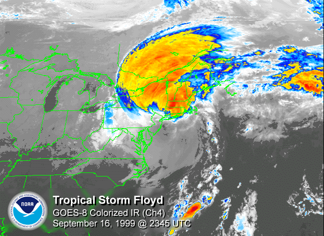
- 1999 September 17–18 Hurricane FloydHurricane FloydHurricane Floyd was the sixth named storm, fourth hurricane, and third major hurricane in the 1999 Atlantic hurricane season. Floyd triggered the third largest evacuation in US history when 2.6 million coastal residents of five states were ordered from their homes as it approached...
– After paralleling much of the U.S. East Coast, Tropical Storm FloydHurricane FloydHurricane Floyd was the sixth named storm, fourth hurricane, and third major hurricane in the 1999 Atlantic hurricane season. Floyd triggered the third largest evacuation in US history when 2.6 million coastal residents of five states were ordered from their homes as it approached...
moves into Connecticut, and tracks northward through Maine. Floyd causes large power outages and flood damage across the region, with over five inches (130 mm) of rain falling over most of the area. Danbury, ConnecticutDanbury, ConnecticutDanbury is a city in northern Fairfield County, Connecticut, United States. It had population at the 2010 census of 80,893. Danbury is the fourth largest city in Fairfield County and is the seventh largest city in Connecticut....
received up to 15 inches (380 mm) of rain from the storm, resulting in extensive flooding in the city and surrounding areas. Mudslides were reported in the Berkshire Mountains of western MassachusettsMassachusettsThe Commonwealth of Massachusetts is a state in the New England region of the northeastern United States of America. It is bordered by Rhode Island and Connecticut to the south, New York to the west, and Vermont and New Hampshire to the north; at its east lies the Atlantic Ocean. As of the 2010...
. Several major highways and a countless number of local roads in Connecticut and Massachusetts were closed for several days due to flooding, and downed trees and power lines. Hurricane force wind gusts were observed in southern Rhode Island: North Kingston unofficially 90 mph.Wind gusts to 76 mph at New Bedford Hurricane Dike in New Bedford, Massachusetts and 73 mph in Hyannis, Massachusetts.
2001–2004
- June 17, 2001 – Tropical Storm AllisonTropical Storm AllisonTropical Storm Allison was a tropical storm that devastated southeast Texas in June of the 2001 Atlantic hurricane season. The first storm of the season, Allison lasted an unusually long period of time for a June storm, remaining tropical or subtropical for 15 days...
brushes southern New England as a subtropical storm. In Connecticut, rainfall peaks at 7.2 inches (183 mm) in PomfretPomfret, ConnecticutPomfret is a town in Windham County, Connecticut, United States. The population was 3,798 at the 2000 census.-Geography:According to the United States Census Bureau, the town has a total area of , of which, of it is land and of it is water....
, closing several roads and causing minor damage to numerous houses. In Rhode Island, the rainfall washes out several roads. - September 11, 2002 – The interaction between Hurricane GustavHurricane Gustav (2002)Hurricane Gustav was a Category 2 hurricane that paralleled the East Coast of the United States in September during the 2002 Atlantic hurricane season. It was the seventh named storm and first hurricane of the season...
and the non-tropical system causes strong winds that affected areas of coastal New EnglandNew EnglandNew England is a region in the northeastern corner of the United States consisting of the six states of Maine, New Hampshire, Vermont, Massachusetts, Rhode Island, and Connecticut...
, mainly in eastern New YorkNew YorkNew York is a state in the Northeastern region of the United States. It is the nation's third most populous state. New York is bordered by New Jersey and Pennsylvania to the south, and by Connecticut, Massachusetts and Vermont to the east...
and MassachusettsMassachusettsThe Commonwealth of Massachusetts is a state in the New England region of the northeastern United States of America. It is bordered by Rhode Island and Connecticut to the south, New York to the west, and Vermont and New Hampshire to the north; at its east lies the Atlantic Ocean. As of the 2010...
. The winds down trees and power lines, and several homes and cars are damaged by fallen trees; about 19,000 homes lost power in Massachusetts.
- Mid-September, 2002 – The remnants of Tropical Storm HannaTropical Storm Hanna (2002)Tropical Storm Hanna was a moderately strong tropical storm that affected the Gulf Coast and Southeastern regions of the United States. The tenth tropical cyclone and ninth named storm of the 2002 Atlantic hurricane season, Hanna formed through the complex interaction of a surface trough, a...
contribute to around 1 in (25 mm) of rainfall in VermontVermontVermont is a state in the New England region of the northeastern United States of America. The state ranks 43rd in land area, , and 45th in total area. Its population according to the 2010 census, 630,337, is the second smallest in the country, larger only than Wyoming. It is the only New England...
. - September 28, 2002 – The extratropical remnants of Hurricane IsidoreHurricane IsidoreHurricane Isidore was the ninth named storm and the second hurricane in the 2002 Atlantic hurricane season. Isidore was the fifth of eight named storms to occur in September. The tropical cyclone peaked as a Category 3 hurricane, causing damage as well as four fatalities in Jamaica, Cuba, Mexico,...
produce widespread light rainfall across the region. No damages or flooding were reported. - Early September, 2003 – Hurricane FabianHurricane FabianHurricane Fabian was a powerful Cape Verde-type hurricane that hit Bermuda in early September during the 2003 Atlantic hurricane season. Fabian, the sixth named storm, fourth hurricane, and first major hurricane of the season, developed from a tropical wave in the tropical Atlantic Ocean on August 25...
produces moderate surfing conditions along the East Coast of the United StatesEast Coast of the United StatesThe East Coast of the United States, also known as the Eastern Seaboard, refers to the easternmost coastal states in the United States, which touch the Atlantic Ocean and stretch up to Canada. The term includes the U.S...
. - September 4, 2003 – The remnants of Tropical Storm GraceTropical Storm Grace (2003)Tropical Storm Grace was a weak tropical storm that struck Texas in the 2003 Atlantic hurricane season. The eleventh tropical depression and the seventh tropical storm of the season, Grace was also the weakest storm of the season. On August 30 the storm developed from a long-track tropical wave in...
drop light to moderate rainfall throughout the region, though no significant damages are reported. - September 17, 2003 – The dissipating remnants of Tropical Storm HenriTropical Storm Henri (2003)Tropical Storm Henri was weak a tropical storm that formed in the 2003 Atlantic hurricane season. The eighth storm of the season, Henri was one of six tropical cyclones to hit the United States in the year. Henri formed from a tropical wave in the Gulf of Mexico in early September, and crossed over...
produce light rainfall. - September 19, 2003 – Hurricane IsabelHurricane IsabelHurricane Isabel was the costliest and deadliest hurricane in the 2003 Atlantic hurricane season. The ninth named storm, fifth hurricane, and second major hurricane of the season, Isabel formed near the Cape Verde Islands from a tropical wave on September 6 in the tropical Atlantic Ocean...
passes far to the west, though rainfall reaches 1 inch (25 mm) in portions of western Connecticut and Massachusetts, and in portions of New Hampshire and Maine. Falling trees from moderate winds downed power lines across the region, causing sporadic power outages. Two people die as a result of the hurricane, both due to the rough surf. Damage in Vermont totals about $100,000 (2003 USD, $117,000 in 2008 USD). - Early October, 2003 – The interaction between Hurricane KateHurricane Kate (2003)Hurricane Kate was the second-longest tropical cyclone in the 2003 Atlantic hurricane season. The eleventh tropical storm, fifth hurricane, and third major hurricane of the season, Kate developed from a tropical wave in the central tropical Atlantic on September 25. Its unusual track included four...
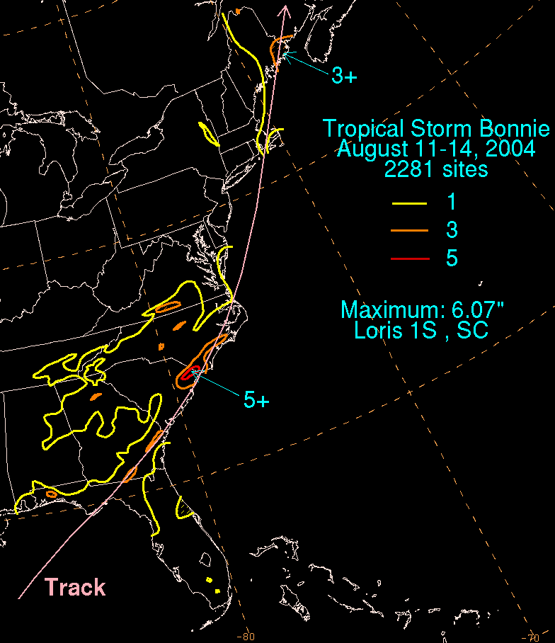
and a high pressure area to its north produced 3 to 4 foot (1 m) waves along the coast. - August 14, 2004 – The extratropical remnants of Tropical Storm BonnieTropical Storm Bonnie (2004)Tropical Storm Bonnie was a small tropical storm that made landfall on Florida in August 2004. The second storm of the 2004 Atlantic hurricane season, Bonnie developed from a tropical wave on August 3 to the east of the Lesser Antilles. After moving through the islands, its fast forward motion...
produce heavy rainfall, with localized totals of up to 10 inches (250 mm). The rainfall floods or washes out roads across the eastern Maine. In Aroostook County, MaineAroostook County, MaineAroostook County is a county located in the U.S. state of Maine. In 2010, its population was 71,870. In land area, it is the largest county in the state and the largest U.S. county east of the Mississippi River. Its seat is Houlton...
, the rainfall caused a mudslide, narrowing a county road to one lane.
- August 15, 2004 – Tropical Storm CharleyHurricane CharleyHurricane Charley was the third named storm, the second hurricane, and the second major hurricane of the 2004 Atlantic hurricane season. Charley lasted from August 9 to August 15, and at its peak intensity it attained 150 mph winds, making it a strong Category 4 hurricane on the...
dissipates near southern Massachusetts, though the remnant moisture produces up to 5 in (127 mm) of rainfall, particularly in Maine. In Rhode IslandRhode IslandThe state of Rhode Island and Providence Plantations, more commonly referred to as Rhode Island , is a state in the New England region of the United States. It is the smallest U.S. state by area...
, one man drowned in a rip current generated by the system. - August 31, 2004 – Moisture from Hurricane GastonHurricane Gaston (2004)Hurricane Gaston was a minimal hurricane that made landfall in South Carolina on August 29, 2004. It then crossed North Carolina and Virginia before exiting to the northeast and dissipating. The storm killed nine people — eight of them directly — and caused $130 million in damage....
drops up to 3.69 in (93.7 mm) of rainfall. - August 31, 2004 – Tropical Storm HermineTropical Storm Hermine (2004)Tropical Storm Hermine was a moderate tropical storm that made landfall in southeastern Massachusetts. The eighth tropical cyclone and named storm of the 2004 Atlantic hurricane season, it formed from the same frontal zone over the western Atlantic that spawned Hurricane Gaston. Hermine remained...
comes ashore near New Bedford, MassachusettsNew Bedford, MassachusettsNew Bedford is a city in Bristol County, Massachusetts, United States, located south of Boston, southeast of Providence, Rhode Island, and about east of Fall River. As of the 2010 census, the city had a total population of 95,072, making it the sixth-largest city in Massachusetts...
as a minimal tropical storm. Damage was minimal, and effects were limited to gusty winds and light rainfall. - September 10, 2004 – The remnants of Hurricane FrancesHurricane FrancesHurricane Frances was the sixth named storm, the fourth hurricane, and the third major hurricane of the 2004 Atlantic hurricane season. The system crossing the open Atlantic during mid to late August, moving to the north of the Lesser Antilles while strengthening. Its outer bands affected Puerto...
produce light, yet widespread rainfall; the system eventually crosses northern Maine. - September 19, 2004 – A plume of moisture breaks off from the remnants of Hurricane IvanHurricane IvanHurricane Ivan was a large, long-lived, Cape Verde-type hurricane that caused widespread damage in the Caribbean and United States. The cyclone was the ninth named storm, the sixth hurricane and the fourth major hurricane of the active 2004 Atlantic hurricane season...
and progresses northward, producing heavy rainfall across portions of the Mid-Atlantic and New England. The rain causes extensive roadway flooding in Connecticut, and results it minor river flooding in other areas. - September 29, 2004 – Moisture from the remnants of Hurricane JeanneHurricane JeanneHurricane Jeanne was the deadliest hurricane in the 2004 Atlantic hurricane season. It was the tenth named storm, the seventh hurricane, and the fifth major hurricane of the season, as well as the third hurricane and fourth named storm of the season to make landfall in Florida...
storm produce light to heavy rainfall, with totals of over 7 inches (175 mm) on Nantucket.
2005–present
- June 15, 2005 – After being absorbed into a frontal waveWeather frontA weather front is a boundary separating two masses of air of different densities, and is the principal cause of meteorological phenomena. In surface weather analyses, fronts are depicted using various colored lines and symbols, depending on the type of front...
, the remnants of Tropical Storm ArleneTropical Storm Arlene (2005)Tropical Storm Arlene was an unusually large and early-forming tropical storm forming during the 2005 Atlantic hurricane season. It was the first storm of the season, which would become the most active on record. Tropical Storm Arlene formed near Honduras on June 8 and moved northwards...
drop light rainfall in Northern New England. - July 8, 2005 – The extratropical remnants of Hurricane CindyHurricane Cindy (2005)Hurricane Cindy was a tropical cyclone that briefly reached minimal hurricane strength in the Gulf of Mexico during July in the 2005 Atlantic hurricane season and made landfall in Louisiana. It was the third named storm and first hurricane of the season...
produce moderate rainfall in northern Vermont, generally within the range of 1 to 3 in (25.4 to 76.2 mm). - August 31, 2005 – The remnants of Hurricane KatrinaHurricane KatrinaHurricane Katrina of the 2005 Atlantic hurricane season was a powerful Atlantic hurricane. It is the costliest natural disaster, as well as one of the five deadliest hurricanes, in the history of the United States. Among recorded Atlantic hurricanes, it was the sixth strongest overall...
drop up to 4.17 in (105.9 mm) of rain and cause gusty winds that blew trees and tree limbs, primarily across Vermont, New Hampshire, and Massachusetts. - September 17, 2005 – Tropical Storm OpheliaHurricane Ophelia (2005)Hurricane Ophelia was the fifteenth named tropical cyclone and the eighth hurricane of the 2005 Atlantic hurricane season. It was a long-lived storm that was most remembered for its very erratic and extremely slow track off the East Coast of the United States, alternating several times between...
brushes MassachusettsMassachusettsThe Commonwealth of Massachusetts is a state in the New England region of the northeastern United States of America. It is bordered by Rhode Island and Connecticut to the south, New York to the west, and Vermont and New Hampshire to the north; at its east lies the Atlantic Ocean. As of the 2010...
with gusty winds and heavy rainfall.
- October 7 – October 12, 2005 – The remnants of Tropical Storm TammyTropical Storm Tammy (2005)Tropical Storm Tammy was a short lived tropical storm during October in the 2005 Atlantic hurricane season which caused minor damage to the southeastern United States. More significant, however were its remnants which contributed to the Northeast U.S. flooding of October 2005.Tropical Storm Tammy...
and Subtropical Depression Twenty-Two contribute to the Northeast U.S. flooding of October 2005Northeast U.S. flooding of October 2005In October 2005, remnants of Tropical Storm Tammy and Subtropical Depression Twenty-Two merged with incoming continental cold fronts to produce torrential rains over interior New England, as well as over parts of New Jersey and New York. Particularly hard hit was the state of New Hampshire, which...
, which killed 10 people and contributed to the wettest month on record in locales throughout the Northeastern United States. - June 15, 2006 – The extratropical remnants of Tropical Storm AlbertoTropical Storm Alberto (2006)Tropical Storm Alberto was the first tropical storm of the 2006 Atlantic hurricane season. Forming on June 10 in the northwestern Caribbean, the storm moved generally to the north, reaching a maximum intensity of 70 mph before weakening and moving ashore in the Big Bend area of Florida on...
drop rainfall throughout the region, peaking at 1.98 in (50.3 mm) at Windsor Locks, ConnecticutWindsor Locks, ConnecticutWindsor Locks is a town located in Hartford County, Connecticut, United States. As of the 2000 census, its population was 12,043. It is the site of Bradley International Airport, which serves the Greater Hartford-Springfield region. It is also the site of the New England Air Museum...
. - July 21, 2006 – Tropical Storm BerylTropical Storm Beryl (2006)Tropical Storm Beryl was the third tropical storm of the 2006 Atlantic hurricane season. Developing from a tropical disturbance on July 18, it tracked generally northward, and strengthened to attain peak winds of 60 mph under generally favorable conditions. After turning to the northeast,...
makes landfall on Nantucket, generating waves 10 feet (3 m) in height as the storm approached the island. Light rainfall and gusty winds were also reported there, and in portions of Massachusetts. - September 3, 2006 – The extratropical remnants of Hurricane ErnestoHurricane Ernesto (2006)Hurricane Ernesto was the costliest tropical cyclone of the 2006 Atlantic hurricane season. The sixth tropical storm and first hurricane of the season, Ernesto developed from a tropical wave on August 24 in the eastern Caribbean Sea...
drop light rainfall; 1.72 in (43.7 mm) of precipitation is reported at Marlboro, VermontMarlboro, VermontMarlboro is a town in Windham County, Vermont, United States. The population was 978 at the 2000 census. The town is home to both the Southern Vermont Natural History Museum and Marlboro College, which each summer hosts the Marlboro Music School and Festival....
. - June 4, 2007 – The extratropical remnants of Tropical Storm BarryTropical Storm Barry (2007)Tropical Storm Barry was a rapidly-forming tropical cyclone that made landfall on Florida, United States, in early June 2007. The second named storm of the 2007 Atlantic hurricane season, Barry developed from a trough of low pressure in the southeastern Gulf of Mexico on June 1...
enter the region, producing moderate rainfall that peaked at 3.19 inches (81 mm) at Taunton, MassachusettsTaunton, MassachusettsTaunton is a city in Bristol County, Massachusetts, United States. It is the seat of Bristol County and the hub of the Greater Taunton Area. The city is located south of Boston, east of Providence, north of Fall River and west of Plymouth. The City of Taunton is situated on the Taunton River...
. - November 3, 2007 – As an extratropical hurricane, Hurricane NoelHurricane NoelThe name Noel has been used for three tropical cyclones in the Atlantic Ocean.* 1995's Hurricane Noel - reached hurricane strength far from land and was absorbed by a cold front without threatening land....
hits coastal MassachusettsMassachusettsThe Commonwealth of Massachusetts is a state in the New England region of the northeastern United States of America. It is bordered by Rhode Island and Connecticut to the south, New York to the west, and Vermont and New Hampshire to the north; at its east lies the Atlantic Ocean. As of the 2010...
, Rhode IslandRhode IslandThe state of Rhode Island and Providence Plantations, more commonly referred to as Rhode Island , is a state in the New England region of the United States. It is the smallest U.S. state by area...
and MaineMaineMaine is a state in the New England region of the northeastern United States, bordered by the Atlantic Ocean to the east and south, New Hampshire to the west, and the Canadian provinces of Quebec to the northwest and New Brunswick to the northeast. Maine is both the northernmost and easternmost...
with hurricane-force wind gusts of up to 89 mph (143.2 km/h). with sustained winds topping out at 59 mph (95 km/h). Power outages were widespread; about 80,000 customers in Massachusetts and 9,000 in Maine lost electric power, mostly on Cape Cod. Heavy rainfall, high seas, and coastal flooding also occurred. - September 6, 2008 – Tropical Storm HannaHurricane Hanna (2008)Hurricane Hanna was the deadliest storm of the 2008 Atlantic hurricane season. The storm was the eighth tropical cyclone and fourth hurricane of the 2008 Atlantic hurricane season. It formed east-northeast of the northern Leeward Islands on August 28...
makes landfall at Myrtle Beach, South CarolinaMyrtle Beach, South CarolinaMyrtle Beach is a coastal city on the east coast of the United States in Horry County, South Carolina. It is situated on the center of a large and continuous stretch of beach known as the Grand Strand in northeastern South Carolina. It is considered to be a major tourist destination in the...
and proceeds northeastward through the Mid Atlantic states and New England, dropping moderate to heavy rainfall and spawning gusty winds across southern New England. - September 15, 2008 – The remnants of Hurricane IkeHurricane IkeHurricane Ike was the second-costliest hurricane ever to make landfall in the United States, the costliest hurricane ever to impact Cuba and the second most active hurricane to reach the Canadian mainland in the Great Lakes Region after Hurricane Hazel in 1954...
reach northern New England, though no effects are reported. - September 28, 2008 – Hurricane KyleHurricane Kyle (2008)Hurricane Kyle was the eleventh tropical storm and sixth hurricane of the 2008 Atlantic hurricane season. It formed from a strong tropical disturbance that tracked across the northeastern Caribbean Sea in the third week of September...
passes to the east as it heads towards Canada, affecting Maine with heavy rainfall and gusty winds that caused scattered power outages. Up to 7.15 in (181.6 mm) of precipitation falls in Hancock County, MaineHancock County, MaineHancock County is a county located in the U.S. state of Maine. As of 2010, the population was 54,418. Its county seat is Ellsworth. It was incorporated on June 25, 1789...
. - August 21, 2009– Hurricane BillHurricane Bill (2009)Hurricane Bill was a relatively large Atlantic tropical cyclone, attaining a maximum gale-diameter of 460 mi . A Cape Verde type hurricane, Bill originated from a tropical wave that emerged from the western coast of Africa on August 12, and organized into a tropical depression near the Cape...
went just offshore of New England causing very heavy surf, and a period of rain and gusty winds over Southeastern Massachusetts. - August 29, 2009– Tropical Storm DannyTropical Storm Danny (2009)Tropical Storm Danny was a weak and disorganized tropical cyclone that formed in August 2009. The fourth tropical system and third named storm of the 2009 Atlantic hurricane season, Danny developed on August 26 from the interaction between a westward-moving tropical wave and an upper-level trough...
passed over Nantucket as an extra-tropical storm, causing up to 2 inches of rain in Massachusetts and Rhode Island, and brought wind gusts up to 60 mph off the coast of Nantucket and Maine. - November 12, 2009– Hurricane IdaHurricane Ida (2009)Hurricane Ida was the strongest landfalling tropical cyclone during the 2009 Atlantic hurricane season, crossing the coastline of Nicaragua with winds of 80 mph . The remnants of the storm became a powerful nor'easter that caused widespread damage along coastal areas of the Mid-Atlantic States...
after hitting the northeast gulf coast as a tropical storm, redeveloped off the Carolina coast as a strong nor'easter, bringing severe damage as far north as New Jersey, where severe flooding, beach erosion, and strong winds were reported. As the center of the storm moved out to sea, a batch of moisture broke off of it, and moved north, bringing moderate rain to New England. The storm caused millions of dollars in damage. - September 4, 2010– Hurricane EarlHurricane Earl (2010)Hurricane Earl was a long-lived, powerful tropical cyclone which became the first major hurricane to threaten New England since Hurricane Bob in 1991. The fifth named storm of the 2010 season, Earl developed out of a tropical wave roughly west of the Cape Verde Islands on August 25...
passed about 90 miles offshore, but still brought heavy rain, large waves, and tropical storm force gusts to Cape CodCape CodCape Cod, often referred to locally as simply the Cape, is a cape in the easternmost portion of the state of Massachusetts, in the Northeastern United States...
. The heaviest rain affected areas such as Nantucket, Martha's Vinyard, and areas over MaineMaineMaine is a state in the New England region of the northeastern United States, bordered by the Atlantic Ocean to the east and south, New Hampshire to the west, and the Canadian provinces of Quebec to the northwest and New Brunswick to the northeast. Maine is both the northernmost and easternmost...
, while the strongest wind was a recorded gust of 58 mph near Hyannis, Massachusetts. Sustained winds were of 29 to 35 miles per hour, just at and below tropical storm force.
- August 28, 2011– Hurricane IreneHurricane Irene (2011)Hurricane Irene was a large and powerful Atlantic hurricane that left extensive flood and wind damage along its path through the Caribbean, the United States East Coast and as far north as Atlantic Canada in 2011...
weakened to a tropical storm immediately after landfall, produced high winds, heavy rains, and flash flooding especially in Western New England. Widespread power outages also reported, with over 450,000 New England customers without power. Flooding was particularly severe in VermontVermontVermont is a state in the New England region of the northeastern United States of America. The state ranks 43rd in land area, , and 45th in total area. Its population according to the 2010 census, 630,337, is the second smallest in the country, larger only than Wyoming. It is the only New England...
, which experienced the worst flooding in centuries. In the end, the storm left at least 16 people dead throughout New England, with ten deaths in ConnecticutConnecticutConnecticut is a state in the New England region of the northeastern United States. It is bordered by Rhode Island to the east, Massachusetts to the north, and the state of New York to the west and the south .Connecticut is named for the Connecticut River, the major U.S. river that approximately...
.
Landfalls
New England hurricanes have made landfall on many occasions. Normally, due to cold waters and fast-moving winds, hurricanes do not last long so the ones that do make landfall are normally weak, with category 3 being rare.The following tables are a list of those hurricanes that did make landfall in New England:
19th century
The 19th century saw a few notable storms. In 1869 an intense Category 3 hurricane struck Southeastern New England. Also making landfall were the Saxby Gale, San Felipe Hurricane, Gale of 1878, and the Sea Islands Hurricane. Since hurricanes were not named and fewer records were kept at the time, the information on some of the storms remains incomplete.| Storm | Category Saffir-Simpson Hurricane Scale The Saffir–Simpson Hurricane Scale , or the Saffir–Simpson Hurricane Wind Scale , classifies hurricanes — Western Hemisphere tropical cyclones that exceed the intensities of tropical depressions and tropical storms — into five categories distinguished by the intensities of their sustained winds... |
Season | Date of landfall | |
|---|---|---|---|---|
| Peak intensity Saffir-Simpson Hurricane Scale The Saffir–Simpson Hurricane Scale , or the Saffir–Simpson Hurricane Wind Scale , classifies hurricanes — Western Hemisphere tropical cyclones that exceed the intensities of tropical depressions and tropical storms — into five categories distinguished by the intensities of their sustained winds... |
Intensity at landfall | |||
| Hurricane Six | Category 3 | Category 3 | 1869 | September 9, 1869 |
| 1869 Saxby Gale 1869 Saxby Gale The Saxby Gale was the name given to a tropical cyclone which struck eastern Canada's Bay of Fundy region on the night of October 4-5, 1869. The storm was named for Lieutenant Stephen Martin Saxby, a naval instructor and amateur astronomer who, based on his astronomical studies, had predicted... |
Category 2 | Category 2 | 1869 | October 4, 1869 |
| Hurricane Five | Category 1 | Tropical Storm | 1872 | October 27, 1872 |
| Hurricane Six | Category 1 | Tropical Storm | 1874 | September 30, 1874 |
| San Felipe Hurricane | Category 3 | Tropical Depression | 1876 | September 19, 1876 |
| Unnamed 1877 Atlantic hurricane season The 1877 Atlantic hurricane season lasted from mid-summer to late-fall. Records show that in 1877 there were eight cyclones. There was five tropical storms, three became hurricanes and one those hurricane became a major hurricane . Most notably, Hurricane Four caused 84 fatalities in the United... |
Category 3 | Extratropical Storm | 1877 | October 5, 1877 |
| Gale of 1878 Gale of 1878 The Gale of 1878, was an intense Category 2 hurricane that caused extensive damage from Cuba to New England.-Meteorological history:A tropical storm formed off the coast of Jamaica on October 18, 1878, and moved nearly due north. On October 20, the storm reached hurricane status and on October 21,... |
Category 2 | Extratropical Storm | 1878 | October 24, 1878 |
| Hurricane Two | Category 3 | Category 1 | 1879 | August 19, 1879 |
| Tropical Storm Eleven | Tropical Storm | Extratropical Storm | 1880 | October 23, 1880 |
| Hurricane Three | Category 3 | Tropical Storm | 1888 | August 22, 1888 |
| Tropical Storm Five | Tropical Storm | Extratropical Storm | 1888 | September 12, 1888 |
| Hurricane Six | Category 1 | Category 1 | 1888 | September 26, 1888 |
| Hurricane Six | Category 2 | Tropical Storm | 1889 | September 25, 1889 |
| Hurricane Four | Category 3 | Category 1 | 1893 | August 24, 1893 |
| 1893 Sea Islands Hurricane 1893 Sea Islands Hurricane On August 27, 1893 a major hurricane which came to be known as the Sea Islands Hurricane struck the United States near Savannah, Georgia. It was one of two deadly hurricanes during the 1893 Atlantic hurricane season; the storm killed an estimated 1,000–2,000 people, mostly from storm surge... |
Category 3 | Tropical Storm | 1893 | August 29, 1893 |
20th century
The 20th century saw eight hurricanes making landfall in New England; out of these the more notable include the New England Hurricane of 1938New England Hurricane of 1938
The New England Hurricane of 1938 was the first major hurricane to strike New England since 1869...
(also called the Long Island Express) whichmade landfall as a major hurricane; Hurricane Carol
Hurricane Carol
Hurricane Carol was among the worst tropical cyclones to affect the New England region of the United States. It developed from a tropical wave near the Bahamas on August 25, 1954, and gradually strengthened as it moved northwestward. On August 27, Carol intensified to reach winds of , but weakened...
did the same sixteen years later. The last hurricane to make landfall in new England was Hurricane Bob
Hurricane Bob
Hurricane Bob was one of the costliest hurricanes in New England history. The second named storm and first hurricane of the 1991 Atlantic hurricane season, Bob developed from an area of low pressure near The Bahamas on August 16. The depression steadily intensified, and became Tropical Storm Bob...
in 1991 as a moderate category 2 hurricane with the highest sustained winds of 100 MPH.
| Storm | Category Saffir-Simpson Hurricane Scale The Saffir–Simpson Hurricane Scale , or the Saffir–Simpson Hurricane Wind Scale , classifies hurricanes — Western Hemisphere tropical cyclones that exceed the intensities of tropical depressions and tropical storms — into five categories distinguished by the intensities of their sustained winds... |
Season | Date of landfall | |
|---|---|---|---|---|
| Peak intensity Saffir-Simpson Hurricane Scale The Saffir–Simpson Hurricane Scale , or the Saffir–Simpson Hurricane Wind Scale , classifies hurricanes — Western Hemisphere tropical cyclones that exceed the intensities of tropical depressions and tropical storms — into five categories distinguished by the intensities of their sustained winds... |
Intensity at landfall | |||
| New England Hurricane of 1938 New England Hurricane of 1938 The New England Hurricane of 1938 was the first major hurricane to strike New England since 1869... |
Category 5 | Category 3 | 1938 1938 Atlantic hurricane season The 1938 Atlantic hurricane season officially began on June 16, 1938, and lasted until October 31, 1938. These dates conventionally delimit the period of each year when most tropical cyclones form in the Atlantic basin.-Tropical Storm One:... |
September 21, 1938 |
| 1944 Great Atlantic Hurricane 1944 Great Atlantic Hurricane The Great Atlantic Hurricane in 1944 was an intense Atlantic hurricane sometimes compared to the New England Hurricane of 1938.-Meteorological history:... |
Category 4 | Category 1 | 1944 1944 Atlantic hurricane season The 1944 Atlantic hurricane season officially began on June 16, 1944, and lasted until October 31, 1944. These dates conventionally delimit the period of each year when most tropical cyclones form in the Atlantic basin.... |
September 15, 1944 |
| Hurricane Able Hurricane Able (1952) Hurricane Able was the only hurricane to make landfall in the United States in the 1952 season. Forming on August 18 off the west coast of Africa, Able moved generally west- to west-northwestward for much of its duration. It was first observed by the Hurricane Hunters on August 25 to the... |
Category 2 | Tropical Depression | 1952 1952 Atlantic hurricane season The 1952 Atlantic hurricane season was the most recent season in which all named storms attained hurricane status, although it was the least active since 1946. The season officially started on June 15; however, a pre-season unnamed storm formed on Groundhog Day, becoming the only storm on... |
September 1, 1952 |
| Hurricane Carol Hurricane Carol Hurricane Carol was among the worst tropical cyclones to affect the New England region of the United States. It developed from a tropical wave near the Bahamas on August 25, 1954, and gradually strengthened as it moved northwestward. On August 27, Carol intensified to reach winds of , but weakened... |
Category 3 | Category 3 | 1954 1954 Atlantic hurricane season The 1954 Atlantic hurricane season caused over $750 million in damage, the most of any season at the time. The season officially began on June 15, and nine days later the first named storm developed. Hurricane Alice developed in the Gulf of Mexico and moved inland along the Rio Grande,... |
August 31, 1954 |
| Hurricane Edna Hurricane Edna Hurricane Edna was a deadly and destructive major hurricane that impacted the United States East Coast in September of the 1954 Atlantic hurricane season. It was one of two hurricanes to strike Massachusetts in that year, the other being Hurricane Carol... |
Category 3 | Category 1 | 1954 | September 11, 1954 |
| Hurricane Diane Hurricane Diane Hurricane Diane was one of three hurricanes to hit North Carolina during the 1955 Atlantic hurricane season, striking an area that had been hit by Hurricane Connie five days earlier... |
Category 3 | Tropical Storm | 1955 1955 Atlantic hurricane season The 1955 Atlantic hurricane season officially began on June 15, 1955, and lasted until November 15, 1955. These dates conventionally delimit the period of each year when most tropical cyclones form in the Atlantic basin. The 1955 season was active, with twelve tropical storms forming.Three... |
August 18–19, 1955 |
| Hurricane Cindy Hurricane Cindy (1959) Hurricane Cindy impacted the Carolinas, the Mid-Atlantic states, New England, and the Canadian Maritime Provinces during the 1959 Atlantic hurricane season. The third storm of the season, Cindy originated from a low-pressure area associated with a cold front located east of northern Florida... |
Category 1 | Tropical Storm | 1959 1959 Atlantic hurricane season The 1959 Atlantic hurricane season officially began on June 15, 1959, and lasted until November 15, 1959. These dates conventionally delimit the period of each year when most tropical cyclones form in the Atlantic basin... |
July 11, 1959 |
| Hurricane Donna Hurricane Donna Hurricane Donna in the 1960 Atlantic hurricane season was a Cape Verde-type hurricane which moved across the Leeward Islands, Puerto Rico, Hispanola, Cuba, The Bahamas, and every state on the East Coast of the United States... |
Category 5 | Category 2 | 1960 1960 Atlantic hurricane season The 1960 Atlantic hurricane season was the least active Atlantic hurricane season since 1952. The season officially began on June 15, 1960, and lasted until November 15, 1960. These dates conventionally delimit the period of each year when most tropical cyclones form in the Atlantic basin... |
September 12, 1960 |
| Hurricane Esther Hurricane Esther (1961) Hurricane Esther was the fifth named storm and fifth hurricane of the 1961 Atlantic hurricane season. A long-lived Category 4 Cape Verde-type hurricane, Esther spent its lifetime offshore, before moving up the East Coast of the United States... |
Category 4 | Tropical Storm | 1961 1961 Atlantic hurricane season The 1961 Atlantic hurricane season officially began on June 15, 1961, and lasted until November 15, 1961. These dates conventionally delimit the period of each year when most tropical cyclones form in the Atlantic basin. The season had seven major hurricanes, the second highest number on... |
September 26, 1961 |
| Hurricane Alma Hurricane Alma (1966) Hurricane Alma was a rare June major hurricane in the 1966 Atlantic hurricane season. It was the earliest continental U.S. hurricane strike within any season since 1908... |
Category 3 | Extr. Storm | 1966 1966 Atlantic hurricane season The 1966 Atlantic hurricane season officially began on June 1, 1966, and lasted until November 30, 1966. These dates conventionally delimit the period of each year when most tropical cyclones form in the Atlantic basin. The 1966 season was near normal with eleven tropical storms... |
June 13, 1966 |
| Tropical Storm Doria Tropical Storm Doria (1971) Tropical Storm Doria was the costliest tropical cyclone in the 1971 Atlantic hurricane season. The fifth tropical storm of the season, Doria developed from a tropical wave on August 20 to the east of the Lesser Antilles, and after five days without development it attained tropical storm status to... |
Tropical Storm | Tropical Depression | 1971 1971 Atlantic hurricane season The 1971 Atlantic hurricane season was fairly active with several notable storms. Hurricane Edith, the strongest of the season, was a Category 5 on the Saffir-Simpson scale, the highest category on the scale. It struck Nicaragua at peak intensity, killing dozens, and later hit southern Louisiana... |
August 29, 1971 |
| Hurricane Agnes Hurricane Agnes Hurricane Agnes was the first tropical storm and first hurricane of the 1972 Atlantic hurricane season. A rare June hurricane, it made landfall on the Florida Panhandle before moving northeastward and ravaging the Mid-Atlantic region as a tropical storm... |
Category 1 | Tropical Storm | 1972 1972 Atlantic hurricane season The 1972 Atlantic hurricane season officially began on June 1, 1972, and lasted until November 30, 1972. These dates conventionally delimit the period of each year when most tropical cyclones form in the Atlantic basin. A strong El Niño kept hurricane activity at a minimum, and in fact the season... |
June 22, 1972 |
| Tropical Storm Carrie Tropical Storm Carrie (1972) Tropical Storm Carrie was a strong tropical storm that affected the East Coast of the United States in early September 1972. The third tropical cyclone of the 1972 Atlantic hurricane season, Carrie formed on August 29 from a complex sequence of meteorological events starting with the emergence of a... |
Tropical Storm | Tropical Storm | 1972 | September 3, 1972 |
| Subtropical Storm Alfa | Tropical Storm | Subtropical Storm | 1973 1973 Atlantic hurricane season The 1973 Atlantic hurricane season was the first season to use the Saffir-Simpson Hurricane Scale, a scale developed in 1971 by Herbert Saffir and Robert Simpson used for rating the intensity of tropical cyclones. The season produced 24 tropical and subtropical cyclones, of which only 8 reached... |
July 30, 1973 |
| Hurricane Belle Hurricane Belle Hurricane Belle was the third tropical storm and first hurricane of the 1976 Atlantic hurricane season. The system formed as a tropical depression northeast of the Bahamas and strengthened as it moved northward towards New York and New England. Belle became a major hurricane that threatened much... |
Category 3 | Category 1 | 1976 1976 Atlantic hurricane season The 1976 Atlantic hurricane season officially began on June 1, 1976, and lasted until November 30, 1976. These dates conventionally delimit the period of each year when most tropical cyclones form in the Atlantic basin... |
August 10, 1976 |
| Hurricane Gloria Hurricane Gloria Hurricane Gloria was a powerful Cape Verde-type hurricane that formed during the 1985 Atlantic hurricane season and prowled the Atlantic Ocean from September 16 to September 28. Gloria reached Category 4 status on the Saffir-Simpson Hurricane Scale near the Bahamas, but weakened significantly... |
Category 4 | Category 1 | 1985 1985 Atlantic hurricane season The 1985 Atlantic hurricane season had the most U.S. landfalling tropical cyclones since 1916. The season officially began on June 1, 1985, and lasted until November 30, 1985... |
September 27, 1985 |
| Tropical Storm Henri | Tropical Storm | Tropical Depression | 1985 | September 23, 1985 |
| Tropical Storm Chris Tropical Storm Chris (1988) Tropical Storm Chris was a weak tropical storm that made landfall in Georgia during the 1988 Atlantic hurricane season. The third storm of the season, Chris was one of five Atlantic storms in the year to make landfall on the United States coastline. Chris formed as a tropical depression in the... |
Tropical Storm | Tropical Depression | 1988 1988 Atlantic hurricane season The 1988 Atlantic hurricane season was a moderately active season that proved costly and deadly, with 15 tropical cyclones directly affecting land. The season officially began on June 1, 1988, and lasted until November 30, 1988, although activity began on May 30 when a tropical... |
August 29, 1988 |
| Hurricane Bob Hurricane Bob Hurricane Bob was one of the costliest hurricanes in New England history. The second named storm and first hurricane of the 1991 Atlantic hurricane season, Bob developed from an area of low pressure near The Bahamas on August 16. The depression steadily intensified, and became Tropical Storm Bob... |
Category 3 | Category 2 | 1991 1991 Atlantic hurricane season The 1991 Atlantic hurricane season was the first season in over 24 years in which no hurricanes developed from tropical waves, which are the source for most North Atlantic tropical cyclones. The hurricane season officially began on June 1, and ended on November 30. It was the least... |
August 19, 1991 |
| Hurricane Bertha Hurricane Bertha (1996) Hurricane Bertha was a strong, early season major hurricane which impacted areas from the Leeward Islands to Atlantic Canada. Bertha originated from a tropical wave which moved off the eastern coast of Africa in early July. By July 3, an area of low pressure developed along the wave... |
Category 3 | Tropical Storm | 1996 1996 Atlantic hurricane season The 1996 Atlantic hurricane season was the first season since 1965 in which all tropical cyclones reached tropical storm status. It officially began on June 1, 1996, and lasted until November 30, 1996... |
July 13, 1996 |
| Hurricane Floyd Hurricane Floyd Hurricane Floyd was the sixth named storm, fourth hurricane, and third major hurricane in the 1999 Atlantic hurricane season. Floyd triggered the third largest evacuation in US history when 2.6 million coastal residents of five states were ordered from their homes as it approached... |
Category 4 | Tropical Storm | 1999 1999 Atlantic hurricane season The 1999 Atlantic hurricane season officially began on June 1, 1999, and lasted until November 30, 1999. These dates conventionally delimit the period of each year when most tropical cyclones form in the Atlantic basin.... |
September 16–17, 1999 |
21st century
So far in the 21st century four tropical cyclones have have made landfallLandfall (meteorology)
Landfall is the event of a tropical cyclone or a waterspout coming onto land after being over water. When a waterspout makes landfall it is reclassified as a tornado, which can then cause damage inland...
in New England. The first was Tropical Storm Hermine in 2004 which affected southeastern Massachusetts with minimal damage. In 2006 Tropical Storm Beryl struck Nantucket, again with minimal damage. Tropical Storm Barry in 2007 made landfall as a remnant extratropical storm which cased heavy rainfall and flooding. In 2009 Tropical storm Danny made landfall in New England as a extratropical storm.
| Storm | Category Saffir-Simpson Hurricane Scale The Saffir–Simpson Hurricane Scale , or the Saffir–Simpson Hurricane Wind Scale , classifies hurricanes — Western Hemisphere tropical cyclones that exceed the intensities of tropical depressions and tropical storms — into five categories distinguished by the intensities of their sustained winds... |
Season | Date of landfall | |
|---|---|---|---|---|
| Peak intensity Saffir-Simpson Hurricane Scale The Saffir–Simpson Hurricane Scale , or the Saffir–Simpson Hurricane Wind Scale , classifies hurricanes — Western Hemisphere tropical cyclones that exceed the intensities of tropical depressions and tropical storms — into five categories distinguished by the intensities of their sustained winds... |
Intensity at landfall | |||
| Tropical Storm Hermine Tropical Storm Hermine (2004) Tropical Storm Hermine was a moderate tropical storm that made landfall in southeastern Massachusetts. The eighth tropical cyclone and named storm of the 2004 Atlantic hurricane season, it formed from the same frontal zone over the western Atlantic that spawned Hurricane Gaston. Hermine remained... |
Tropical Storm | Tropical Storm | 2004 2004 Atlantic hurricane season The 2004 Atlantic hurricane season officially began on June 1, 2004, and lasted until November 30, 2004. These dates conventionally delimit the period of each year when most tropical cyclones form in the Atlantic basin... |
August 31, 2004 |
| Tropical Storm Beryl Tropical Storm Beryl (2006) Tropical Storm Beryl was the third tropical storm of the 2006 Atlantic hurricane season. Developing from a tropical disturbance on July 18, it tracked generally northward, and strengthened to attain peak winds of 60 mph under generally favorable conditions. After turning to the northeast,... |
Tropical Storm | Tropical Storm | 2006 2006 Atlantic hurricane season The 2006 Atlantic hurricane season was significantly less active than the record previous season. It marked the first since 2001 in which no hurricanes made landfall in the United States, and was the first since 1994 that no tropical cyclones formed during October. Following the intense activity of... |
July 21, 2006 |
| Tropical Storm Barry Tropical Storm Barry (2007) Tropical Storm Barry was a rapidly-forming tropical cyclone that made landfall on Florida, United States, in early June 2007. The second named storm of the 2007 Atlantic hurricane season, Barry developed from a trough of low pressure in the southeastern Gulf of Mexico on June 1... |
Tropical Storm | Extr. Storm | 2007 2007 Atlantic hurricane season The 2007 Atlantic hurricane season was an active Atlantic hurricane season that produced 17 tropical cyclones, 15 tropical storms, six hurricanes, and two major hurricanes. It officially started on June 1 and ended on November 30, dates which conventionally delimit the... |
June 4, 2007 |
| Tropical Storm Danny Tropical Storm Danny (2009) Tropical Storm Danny was a weak and disorganized tropical cyclone that formed in August 2009. The fourth tropical system and third named storm of the 2009 Atlantic hurricane season, Danny developed on August 26 from the interaction between a westward-moving tropical wave and an upper-level trough... |
Tropical Storm | Extr. Storm | 2009 2009 Atlantic hurricane season The 2009 Atlantic hurricane season was a below-average year, unlike the 2009 Pacific hurricane season, which was above average, both due to a moderate El Niño. During this year, nine tropical storms formed, the fewest since the 1997 season.An average season has ten tropical storms, six hurricanes... |
August 29, 2009 |
See also
- List of New Jersey hurricanes
- List of Canada hurricanes
- List of New York hurricanes
- Effects of Hurricane Isabel in New York and New EnglandEffects of Hurricane Isabel in New York and New EnglandThe effects of Hurricane Isabel in New York and New England were relatively minor and primarily limited to wind damage. Hurricane Isabel formed from a tropical wave on September 6, 2003 in the tropical Atlantic Ocean...
- Effects of Hurricane Noel in New England
External links
- Bishop Valentine, Sarah. Hurricanes in New England 1635-1996: A Technical Paper. 1996