

List of California rivers
Encyclopedia
List of river
s in California
(U.S. state
), grouped by region.
(arranged north to south; tributaries with those entering nearest the sea first)
article.
 Rivers and streams between Humboldt Bay and the Golden Gate
that empty into the Pacific Ocean
(arranged north to south; tributaries with those entering nearest the sea first):
For details of the Sonoma
and Marin
coasts, see List of watercourses in the San Francisco Bay Area.
or its tributary bays (arranged clockwise, starting at the north side of the Golden Gate
; tributaries are listed from those entering nearest the bays to farthest).
For additional detail on Bay Area creeks, see List of watercourses in the San Francisco Bay Area.
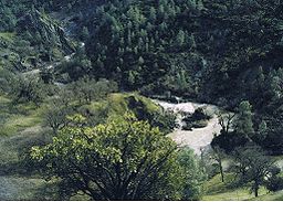
.jpg) Usually an endorheic basin, waters in this region all eventually would reach Tulare Lake
Usually an endorheic basin, waters in this region all eventually would reach Tulare Lake
. This region would overflow into the San Joaquin River during flood years when Tulare Lake overflowed.
For additional detail on Bay Area creeks, see List of watercourses in the San Francisco Bay Area.
between the Golden Gate and Point Arguello
, arranged in order from north to south.
For details of the San Mateo
coast, see List of watercourses in the San Francisco Bay Area.
southeast of Point Arguello, arranged from north to south:
Buena creek (san diego)
:
is a large enclosed valley near the Central Coast which drains into Soda Lake
.
:
in eastern California, from north and proceeding counterclockwise:
River
A river is a natural watercourse, usually freshwater, flowing towards an ocean, a lake, a sea, or another river. In a few cases, a river simply flows into the ground or dries up completely before reaching another body of water. Small rivers may also be called by several other names, including...
s in California
California
California is a state located on the West Coast of the United States. It is by far the most populous U.S. state, and the third-largest by land area...
(U.S. state
U.S. state
A U.S. state is any one of the 50 federated states of the United States of America that share sovereignty with the federal government. Because of this shared sovereignty, an American is a citizen both of the federal entity and of his or her state of domicile. Four states use the official title of...
), grouped by region.
Far North Coast
Rivers and streams between the Oregon border and Humboldt Bay that empty into the Pacific OceanPacific Ocean
The Pacific Ocean is the largest of the Earth's oceanic divisions. It extends from the Arctic in the north to the Southern Ocean in the south, bounded by Asia and Australia in the west, and the Americas in the east.At 165.2 million square kilometres in area, this largest division of the World...
(arranged north to south; tributaries with those entering nearest the sea first)
- Smith RiverSmith River (California)The Smith River is a river on the Pacific coast of northern California in the United States, approximately long. It drains a rugged area of the Pacific Coast Ranges west of the Siskiyou Mountains just south of the Oregon border and north of the watershed of the Klamath River. The catchment area is...
- South Fork Smith River
- North Fork Smith River
- Middle Fork Smith River
- Rowdy Creek
- Klamath RiverKlamath RiverThe Klamath River is an American river that flows southwest through Oregon and northern California, cutting through the Cascade Range to empty into the Pacific Ocean. The river drains an extensive watershed of almost that stretches from the high desert country of the Great Basin to the temperate...
- Terwer Creek
- Blue Creek
- Pecwan Creek
- Trinity RiverTrinity River (California)The Trinity River is the longest tributary of the Klamath River, approximately long, in northwestern California in the United States. It drains an area of the Coast Ranges, including the southern Klamath Mountains, northwest of the Sacramento Valley...
- South Fork Trinity RiverSouth Fork Trinity RiverThe South Fork Trinity River is a major tributary of the Trinity River, in the northern part of the U.S. state of California.It is part of the Klamath River drainage basin. It flows generally northwest from its source in the Klamath Mountains, draining about of mountainous terrain...
- Grouse CreekGrouse Creek (Humboldt County, California)Grouse Creek in Humboldt County, California is a tributary on the west bank of the South Fork of the Trinity River. Its basin lies approximately 20–25 miles east of Eureka, California....
- Hayfork CreekHayfork CreekHayfork Creek is a tributary of the South Fork Trinity River in Northern California in the United States. At over long, it is the river's longest tributary and is one of the southernmost streams in the Klamath Basin...
- East Branch South Fork Trinity River
- Grouse Creek
- North Fork Trinity RiverNorth Fork Trinity RiverThe North Fork Trinity River is a tributary of the Trinity River in the U.S. state of California. It flows south through the Klamath Mountains for about , emptying into the Trinity at Helena, about northeast of Junction City. The river drains an area of . Important tributaries include the East...
- New RiverNew River (Trinity River)The New River is a tributary of the Trinity River in northern California. Running through Denny and Hoboken, it is a good place for advanced kayak and rafting enthusiasts to test their skills. The New River contains rapids ranging from class I to almost class V, with flows ranging from 400-1000+...
- Stuart ForkStuart Fork Trinity RiverThe Stuart Fork Trinity River is a tributary of the Trinity River in the U.S. state of California. The river rises in the Trinity Alps and flows generally southeast into Trinity Lake, a reservoir formed by the Trinity Dam, just north of Buckeye Ridge. Important tributaries include Deer and Hobel...
- South Fork Trinity River
- Copper CreekCopper Creek (California)Copper Creek is a southern tributary of the Klamath River in the U.S. state of California. Arising in the Klamath Mountains, the creek drains a narrow watershed of about...
- Boise CreekBoise CreekBoise Creek is a stream in Humboldt County, California, United States. From its origin on Orleans Mountain it flows 8.5 miles to join the Klamath River about 2.25 miles southeast of Orleans, California...
- Salmon RiverSalmon River (California)The Salmon River is a tributary to the Klamath River in western Siskiyou County, California.The river has its origins in the high mountains of the Trinity Alps, Russian Mountains, and Marble Mountains...
- Scott RiverScott RiverThe Scott River is a river in Siskiyou County, California, United States. It is a tributary of the Klamath River, one of the largest rivers in California....
- Canyon Creek
- Snicktaw Creek
- Shackleford Creek
- Shasta RiverShasta RiverThe Shasta River is a tributary of the Klamath River, approximately long, in northern California in the United States. It drains the Shasta Valley on the west and north sides of Mount Shasta in the Cascade Range....
- Parks Creek
- Big Springs Creek
- Lost RiverLost River (California)Lost River begins and ends in a closed basin in northern California and southwestern Oregon in the United States. The river, long, flows in an arc from Clear Lake Reservoir in Modoc County, California, through Klamath County, Oregon to Tule Lake in Siskiyou County...
, which is mostly in California but joins the Klamath in Oregon
- Redwood Creek (Humboldt County)Redwood Creek (Humboldt County)Redwood Creek is a river in Humboldt County, California. The river's headwaters are in the Coast Range at about and it flows roughly northwest until it empties into the Pacific Ocean near the small town of Orick, the only development in the -watershed....
- Little River (Humboldt County)
- Mad RiverMad River (California)The Mad River is a river in upper Northern California. It flows for in a roughly northwest direction through Trinity County and then Humboldt County, draining a watershed into the Pacific Ocean north of the college town of Arcata near Arcata-Eureka Airport in McKinleyville...
- Maple Creek (California)
Humboldt Bay
Primary streams entering Humboldt Bay are listed north to south beginning north of the entrance to the bay and continuing in a clockwise direction. Tributaries entering nearest the bay are listed first. For a detailed listing of minor creeks and sloughs that drain into the bay and ultimately to the Pacific Ocean, see the Humboldt BayHumboldt Bay
Humboldt Bay is a natural bay and a multi-basin, bar-built coastal lagoon located on the rugged North Coast of California, United States entirely within Humboldt County. The regional center and county seat of Eureka and the college town of Arcata adjoin the bay, which is the second largest enclosed...
article.
- Jolly Giant Creek
- Jacoby Creek
- Eureka Slough
- Freshwater Slough
- Freshwater Creek
- Freshwater Slough
- Elk River (California)
- Salmon Creek (Northern Humboldt County)
North Coast
Golden Gate
The Golden Gate is the North American strait connecting San Francisco Bay to the Pacific Ocean. Since 1937 it has been spanned by the Golden Gate Bridge...
that empty into the Pacific Ocean
Pacific Ocean
The Pacific Ocean is the largest of the Earth's oceanic divisions. It extends from the Arctic in the north to the Southern Ocean in the south, bounded by Asia and Australia in the west, and the Americas in the east.At 165.2 million square kilometres in area, this largest division of the World...
(arranged north to south; tributaries with those entering nearest the sea first):
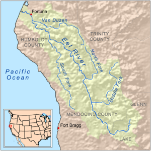
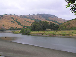
- Eel RiverEel River (California)The Eel River is a major river system of the northern Pacific coast of the U.S. state of California. Approximately 200 miles long, it drains a rugged area in the California Coast Ranges between the Sacramento Valley and the ocean. For most of its course, the river flows northwest, parallel to the...
- South Fork Eel RiverSouth Fork Eel RiverThe South Fork Eel River is the longest and largest tributary of the Eel River, in the north-central part of the U.S. state of California. The river flows north from Laytonville to Dyerville/Founders' Grove where it joins the Eel River on the left bank...
(see List of tributaries of the South Fork Eel River for detailed list of tributaries)- Bull Creek (Humboldt County)
- East Branch South Fork Eel RiverEast Branch South Fork Eel RiverThe East Branch South Fork Eel River, a tributary of the South Fork Eel River, is formed by the confluence of Cruso Cabir Creek and Elkhorn Creek, in Mendocino County in the U.S. state of California. The river is roughly long, meandering west to its confluence with the South Fork Eel at Benbow...
- Cedar CreekCedar Creek (South Fork Eel River)Cedar Creek is an tributary of the South Fork Eel River in Mendocino County in the U.S. state of California. The creek begins southeast of Red Mountain, at an elevation of . It makes an S-curve west-northwest then bends sharply south, dropping into the valley of the South Fork Eel. The confluence...
- Tenmile Creek
- North Fork Eel RiverNorth Fork Eel RiverThe North Fork Eel River is the smallest of four major tributaries of the Eel River in northwestern California in the United States. It drains a rugged wilderness area of about in the California Coast Ranges, and flows through national forests for much of its length...
- Middle Fork Eel RiverMiddle Fork Eel RiverThe Middle Fork Eel River is a major tributary of the Eel River of northwestern California in the United States. It drains a rugged and sparsely populated region of the Yolla Bolly Mountains, part of the California Coast Range, in Trinity and Mendocino Counties...
- North Fork Middle Fork Eel River
- Thatcher Creek
- Black Butte RiverBlack Butte RiverThe Black Butte River is located in the Mendocino National Forest of northern California in Lake, Glenn and Mendocino counties. It is a tributary to the Middle Fork Eel River and flows northward for from its headwaters near Round Mountain to the confluence with the Middle Fork Eel River.The...
- Rice ForkRice ForkThe Rice Fork is a tributary of the Eel River in Lake County, California. The Rice Fork begins on the upper northwest side of Goat Mountain, on the Colusa-Lake County line, at an elevation of over...
- Van Duzen RiverVan Duzen RiverThe Van Duzen River is a river on the north coast of California. It is a major tributary of the Eel River and drains , mostly in Humboldt County, with a small portion in Trinity County. The river travels from its headwaters on the west side of the North Coast Range to its confluence with the Eel...
- Yaeger Creek (sometimes spelled "Yager")
- Salt River (Humboldt County)
- South Fork Eel River
- Bear River (Humboldt County)
- Mattole RiverMattole RiverThe Mattole River is a river on the north coast of California, that flows northerly, then westerly into the Pacific Ocean. A short section of the river flows through upper Mendocino County, but the vast majority of its 62-mile run is through southern Humboldt County...
- North Fork Mattole River
- Upper North Fork Mattole River
- Usal CreekUsal CreekUsal Creek is the southernmost drainage basin unbridged by California State Route 1 on California's Lost Coast. The unpaved county road following the westernmost ridge line south from the King Range crosses Usal Creek near the Pacific coast, but the bridge may be removed during winter months...
- Ten Mile RiverTen Mile River (California)Ten Mile River is a river in northern Mendocino County, California, United States. It is named for the fact that its mouth is ten miles north of the mouth of the Noyo River. The middle and north forks of the river are each long, and the river extends for seven more miles from their confluence to...
- Noyo RiverNoyo RiverThe Noyo River is a river on the north coast of California in Mendocino County. The river's headwaters are in the steep Mendocino Range, but downstream the river flows through gently sloping marine terraces before draining into the Pacific Ocean...
- Big RiverBig River (California)The Big River is a river in Mendocino County, California, draining an area of about . The Big River watershed borders the watersheds of the Noyo River to the north, the Eel River and Russian River to the east, and the Little River, Albion River, and Navarro River to the south.The river's...
- Little River (Mendocino County)Little River (Mendocino County)Little River is a westward-flowing stream in Mendocino County, California which empties into the Pacific Ocean in Van Damme State Park near the town of Little River, California. Big River enters the Pacific about farther north....
- Albion RiverAlbion RiverThe Albion River is an river in Mendocino County, California. The river drains about on the Mendocino Coast and empties into the Pacific Ocean near the town of Albion, California, where California State Route 1 crosses it on the Albion River Bridge. The river's overall direction is east to west,...
- Big Salmon Creek
- Little Salmon Creek
- Navarro RiverNavarro RiverThe Navarro River is a river in Mendocino County, California. It flows northwest through the Coastal Range to the Pacific Ocean. Encompassing , its watershed includes the Anderson Valley, a well-known wine-growing region in Mendocino County. The main stem of the Navarro River begins less than ...
- Rancheria Creek
- Anderson Creek
- Garcia RiverGarcia RiverThe Garcia River is a river on the northern coast of California, in southern Mendocino County. The river's watershed covers and its mainstem is long. The watershed receives of precipitation per year near the coast and inland. The watershed's elevation ranges from sea level near the ocean to in...
- Gualala RiverGualala RiverThe Gualala River is a river on the northern coast of California. Most of the river is in Sonoma County, but a portion is in Mendocino County. The headwaters of the river are high in the Coast Range, and it empties into the Pacific Ocean...
- Wheatfield ForkWheatfield Fork Gualala RiverThe Wheatfield Fork Gualala River is a stream in the mountains of western Sonoma County, California which empties into the South Fork Gualala River just east of Sea Ranch, California.-Course:Tributaries include:*Fuller Creek*Haupt Creek*Tobacco Creek...
- Wheatfield Fork
- Russian RiverRussian River (California)The Russian River, a southward-flowing river, drains of Sonoma and Mendocino counties in Northern California. With an annual average discharge of approximately , it is the second largest river flowing through the nine county Greater San Francisco Bay Area with a mainstem 110 miles ...
- East Fork Russian River
For details of the Sonoma
Sonoma County, California
Sonoma County, located on the northern coast of the U.S. state of California, is the largest and northernmost of the nine San Francisco Bay Area counties. Its population at the 2010 census was 483,878. Its largest city and county seat is Santa Rosa....
and Marin
Marin County, California
Marin County is a county located in the North San Francisco Bay Area of the U.S. state of California, across the Golden Gate Bridge from San Francisco. As of 2010, the population was 252,409. The county seat is San Rafael and the largest employer is the county government. Marin County is well...
coasts, see List of watercourses in the San Francisco Bay Area.
San Francisco Bay
Streams that empty into San Francisco BaySan Francisco Bay
San Francisco Bay is a shallow, productive estuary through which water draining from approximately forty percent of California, flowing in the Sacramento and San Joaquin rivers from the Sierra Nevada mountains, enters the Pacific Ocean...
or its tributary bays (arranged clockwise, starting at the north side of the Golden Gate
Golden Gate
The Golden Gate is the North American strait connecting San Francisco Bay to the Pacific Ocean. Since 1937 it has been spanned by the Golden Gate Bridge...
; tributaries are listed from those entering nearest the bays to farthest).
For additional detail on Bay Area creeks, see List of watercourses in the San Francisco Bay Area.
Sacramento River
- Sacramento RiverSacramento RiverThe Sacramento River is an important watercourse of Northern and Central California in the United States. The largest river in California, it rises on the eastern slopes of the Klamath Mountains, and after a journey south of over , empties into Suisun Bay, an arm of the San Francisco Bay, and...
:- Cache Slough
- Steamboat Slough
- Miner Slough
- Lindsey Slough
- Lookout Slough
- Ulatis Creek
- Horse CreekHorse CreekHorse Creek is a stream in Solano County, California which discharges into Ulatis Creek.-Floodplain:The U.S. government has designated a portion of Horse Creek within the 100-year floodplain. In particular, within unincorporated Solano County approximately downstream and upstream of Willow...
- Horse Creek
- Putah CreekPutah CreekPutah Creek is a major stream in Northern California, a tributary of the Yolo Bypass. The creek has its headwaters in the Mayacamas Mountains, a part of the Coast Range...
- American RiverAmerican RiverThe American River is a California watercourse noted as the site of Sutter's Mill, northwest of Placerville, California, where gold was found in 1848, leading to the California Gold Rush...
- North Fork American RiverNorth Fork American RiverThe North Fork American River is the longest branch of the American River in Northern California. It is long from its source at the crest of the Sierra Nevada, near Lake Tahoe, to its mouth at Folsom Lake northeast of Sacramento...
- Middle Fork American River
- North Fork of the Middle Fork American River
- Rubicon RiverRubicon River (California)The Rubicon River is a river in the Sierra Nevada of northern California, west of Lake Tahoe. It is a tributary of the Middle Fork American River, and is long and with a watershed of about . The river's headwaters are in the Crystal Range of the Sierra Nevada, within the Eldorado National Forest's...
- Gerle Creek
- Bunch CreekBunch CreekBunch Creek is a stream in Placer County, California, USA. Bunch Creek is a tributary to the North Fork of the American River, which confluence is to the east at elevation. In reaching that confluence, Brush Creek flows through Bunch Canyon...
- Shirttail Creek
- Middle Fork American River
- South Fork American River
- Slab Creek
- Silver Creek
- North Fork American River
- Dry Creek
- Cache Creek
- Bear Creek
- Forbes CreekForbes CreekForbes Creek is a watercourse in Lake County, California which empties into Clear Lake at the city of Lakeport.In 1989, a major project was undertaken in the Forbes Creek basin by the city of Lakeport...
- Feather RiverFeather RiverThe Feather River is the principal tributary of the Sacramento River, in the Sacramento Valley of Northern California. The river's main stem is about long. Its length to its most distant headwater tributary is about . Its drainage basin is about...
- Bear River
- Yuba RiverYuba RiverThe Yuba River is a tributary of the Feather River in the Sacramento Valley of the U.S. state of California. It is one of the Feather's most important branches, providing about a third of its flow. The main stem of the river is about long, and its headwaters are split into North, Middle and South...
- South Yuba RiverSouth Yuba RiverThe South Yuba River is a left-entering tributary of the Yuba River in the Sierra Nevada that repeatedly crosses Interstate 80 in California....
- Canyon Creek
- Fordyce Creek
- North Yuba RiverNorth Yuba RiverThe North Yuba River is the main tributary of the Yuba River in northern California in the United States. The river is about long and drains from the Sierra Nevada westwards towards the foothills between the mountains and the Sacramento Valley.It rises on the Sierra Crest about northwest of...
- Slate Creek
- Canyon Creek
- Downieville River
- Pauley Creek
- Lavazolla Creek
- Middle Yuba River
- Fall River
- South Yuba River
- North Fork Feather RiverNorth Fork Feather RiverThe North Fork Feather River is a watercourse of the northern Sierra Nevada in the U.S. state of California. It flows generally southwards from its headwaters near Lassen Peak to Lake Oroville, a reservoir formed by Oroville Dam in the foothills of the Sierra, where it runs into the Feather River....
- West Branch Feather RiverWest Branch Feather RiverThe West Branch Feather River is a Lake Oroville tributary that flows generally north-to-south in the North Fork Feather Watershed near the watershed's drainage divide with the...
- Big Kimshew CreekBig Kimshew CreekBig Kimshew Creek is a stream in northern California in the United States, some long. It flows generally SSW from its headwaters in the Lassen National Forest of the Sierra Nevada into the West Branch Feather River, a tributary of the Feather River, a major Northern California river system.The...
- Big Kimshew Creek
- East Branch North Fork Feather River
- Indian Creek
- Last Chance Creek
- Red Clover CreekRed Clover CreekRed Clover Creek is a northeastward-flowing stream originating on Horton Ridge east of the Sierra Nevada crest in Plumas County, California, United States. It courses through Dotta Canyon and the Red Clover Valley, culminating in Last Chance Creek, which flows in turn, into Indian Creek in the...
- Red Clover Creek
- Last Chance Creek
- Spanish Creek
- Indian Creek
- West Branch Feather River
- Middle Fork Feather RiverMiddle Fork Feather RiverThe Middle Fork Feather River is a major river in Plumas and Butte Counties in the U.S. state of California. Nearly long, it drains about of the rugged northern Sierra Nevada range....
- Fall RiverFall River (Plumas County, California)The Fall River is a Lake Oroville source tributary that drains the south portion of the Middle Fork Feather Watershed. The river enters the lake along the shore of the North Arm from the mouth of the North Fork Feather River at the tip of the arm and elevation . The river is notable as the...
- Fall River
- South Fork Feather RiverSouth Fork Feather RiverThe South Fork Feather River is a Lake Oroville tributary in the south portion of the Middle Fork Feather Watershed which drains the Little Grass Valley, California and has several reservoirs....
- Butte Creek
- Stony CreekStony Creek (Sacramento River)Stony Creek is a moderate sized river in north-central California in the United States, and is a tributary of the Sacramento River. It is long and its watershed encompasses . The stream rises in the eastern foothills of the California Coast Ranges and flows generally northeast to where it drains...
- Big Chico CreekBig Chico CreekBig Chico Creek originates on Colby Mountain, located in Tehama County, California. The creek flows to its confluence with the Sacramento River in Butte County...
- Deer Creek
- Mill Creek
- Dye CreekDye CreekDye Creek is an watercourse in Tehama County, California, USA, that is tributary to the Sacramento River. Dye Creek's watershed is situated in north-central California. The Dye Creek watershed contains rugged terrain areas of oak-studded forest, and also provides habitat for numerous understory...
- Payne's CreekPayne's CreekPayne's Creek is a natural watercourse in Tehama County, California. The creek was apparently originally called Paines Creek according to an 1879 land survey map of the area. The town of Paynes Creek was named after the creek....
- Battle CreekBattle Creek (California)Battle Creek is a creek located in Tehama County, California. It is a major tributary to the Sacramento River.The creek is part of a $67 million dollar Chinook salmon restoration project, a PG&E Battle Creek Hydroelectric Project...
- Cottonwood Creek
- Cow Creek
- Clear Creek
- Rock Creek
- Spring Creek
- Spring Creek
- Slickrock Creek
- Boulder Creek
- Flat Creek
- Pit RiverPit RiverThe Pit River is a major river draining from northeastern California into the state's Central Valley. The Pit, the Klamath and the Columbia are the only three rivers in the U.S...
- McCloud RiverMcCloud RiverThe McCloud River is a river that flows east of and parallel to the Sacramento River, long, in northern California in the United States. It drains a scenic mountainous area of the Cascade Range north of Redding...
- Burney Creek
- Hat CreekHat CreekHat Creek is a stream in Shasta County in northern California. The creek rises in two forks on the eastern slopes of Lassen Peak in Lassen Volcanic National Park, and flows northward through Lassen National Forest to its mouth at Lake Britton near Burney, California.Hat Creek is so named because a...
- Fall River
- McCloud River
- Cache Slough
San Joaquin River
- San Joaquin RiverSan Joaquin RiverThe San Joaquin River is the largest river of Central California in the United States. At over long, the river starts in the high Sierra Nevada, and flows through a rich agricultural region known as the San Joaquin Valley before reaching Suisun Bay, San Francisco Bay, and the Pacific Ocean...
:- Marsh CreekMarsh Creek (California)Marsh Creek is a stream in Contra Costa County, California in Northern California which flows to the Sacramento – San Joaquin River Delta at Oakley, California, in Contra Costa County.-History:...
- Mokelumne RiverMokelumne RiverThe Mokelumne River is a river in Northern California. The Upper Mokelumne River originates in the Sierra Nevada mountain range and flows into Pardee Reservoir and then Camanche Reservoir in the Sierra foothills. The Lower Mokelumne River refers to the portion of the river below Camanche Dam...
- Cosumnes RiverCosumnes RiverThe Cosumnes River is a river in northern California in the United States. It rises on the western slope of the Sierra Nevada and flows approximately into the Central Valley, emptying into the Mokelumne River in the Sacramento-San Joaquin Delta.-Name:...
- Dry CreekDry Creek (Mokelumne River)Dry Creek is a stream in northern California which runs from the Sierra Nevada to the Mokelumne River west of Galt.- Tributaries :*North Fork Dry Creek*South Fork Dry Creek*Sutter Creek*Jackson Creek...
- Jackson Creek
- Sutter Creek
- Bear RiverBear River (Mokelumne River tributary)The Bear River is a river in the Sierra Nevada in California. It is a tributary of the Mokelumne River. The river and its watershed are entirely in El Dorado National Forest. The river begins as two forks several miles south of Kirkwood. The forks travel roughly southwest and merge just before the...
- Cosumnes River
- Calaveras RiverCalaveras RiverThe Calaveras River is a river in the California Central Valley. It flows roughly southwest for from the confluence of its north and south forks in Calaveras County to its confluence with the San Joaquin River just west of the city of Stockton....
- Stanislaus RiverStanislaus RiverThe Stanislaus River in California is one of the largest tributaries of the San Joaquin River. The river is long and has north, middle and south forks...
- South Fork Stanislaus River
- Rose CreekRose CreekRose Creek is an urban stream in San Diego, California that drains to Mission Bay. It flows in a north-to-south direction through Rose Canyon and San Clemente Canyon and their tributary canyons. Both Rose Creek and Rose Canyon are named for San Diego pioneer Louis Rose, who had a ranch in the...
- Middle Fork Stanislaus River
- Clark Fork Middle Fork Stanislaus River
- North Fork Stanislaus River
- Griswold Creek
- Beaver Creek
- Hospital CreekHospital CreekHospital Creek, originally Arroyo del Osnital, Hospital Creek is a tributary of the San Joaquin River draining eastern slopes of part of the Diablo Range within San Joaquin County, in the Central Valley of California, USA...
- Ingram CreekIngram CreekIngram Creek, originally Arroyo de la Suerte, is a tributary of the San Joaquin River in Stanislaus County, in the Central Valley of California, USA....
- Tuolumne RiverTuolumne RiverThe Tuolumne River is a California river that flows nearly from the central Sierra Nevada to the San Joaquin River in the Central Valley...
- Dry Creek
- Clavey RiverClavey RiverThe Clavey River is a tributary of the Tuolumne River, about long, located in Tuolumne County, California. The Clavey's headwaters originate in the Emigrant Wilderness in the Stanislaus National Forest. Uniquely, it flows north-south, which is exceptional for a west-slope river in the Sierra...
- South Fork Tuolumne River
- Middle Fork Tuolumne River
- Cottonwood Creek
- Middle Fork Tuolumne River
- Cherry Creek
- Falls CreekFalls Creek (California)Falls Creek, also known as the Falls River, is a tributary of the Tuolumne River in Yosemite National Park, California, United States. The creek begins at the northern boundary of the national park and flows to empty into the Tuolumne at Hetch Hetchy Reservoir, dropping over two well-known...
- Branigan Creek
- Tiltill Creek
- Rancheria Creek
- Breeze Creek
- Piute Creek
- Register Creek
- Ten Lakes Basin Creek
- Cathedral Creek
- South Fork Cathedral Creek
- Conness Creek
- Alkali Creek
- Dingley Creek
- Delaney Creek
- Budd Creek
- Unicorn Creek
- Dana Fork Tuolumne River
- Gaylor Creek
- Parker Pass Creek
- Mono Pass Creek
- Lyell Fork Tuolumne River
- Rafferty Creek
- Evelyn Lake Creek
- Ireland Creek
- Kuna Creek
- Rafferty Creek
- Merced RiverMerced RiverThe Merced River , in the central part of the U.S. state of California, is a -long tributary of the San Joaquin River flowing from the Sierra Nevada into the Central Valley. It is most well known for its swift and steep course through the southern part of Yosemite National Park, and the...
- Dry Creek
- North Fork Merced River
- South Fork Merced RiverSouth Fork Merced RiverThe South Fork Merced River is the largest tributary of the Merced River. Most of the river flows within Yosemite National Park in the Sierra Nevada of California. The river is long, and its drainage basin covers about , of which are in the national park...
- Alder Creek
- Bishop Creek
- Elevenmile Creek
- Rail Creek
- Elevenmile Creek
- Bridalveil CreekBridalveil Creekthumb|300px|right| Hanging valley of Bridalveil Creek, showing its pronounced form which is controlled, in large measure, by sparse diagonal joint structures....
- Yosemite CreekYosemite CreekYosemite Creek Campground, located in the northern area of Yosemite National Park along Tioga Road , is a first-come first-served campground outside of Yosemite Valley. This campground is remote, quiet, and less populated relative to other campgrounds in Yosemite...
- Tenaya Creek
- Snow Creek
- Illilouette Creek
- Fletcher Creek
- Lewis Creek
- Florence Creek
- Lewis Creek
- Red Peak Fork
- Red Devil Creek
- Lyell Fork
- Hutching Creek
- Merced Peak Fork
- Triple Peak Fork
- Foerster Creek
- Chowchilla RiverChowchilla RiverThe Chowchilla River is a river in central California and a minor tributary of the San Joaquin River. It flows for from the western side of the Sierra Nevada Range to the San Joaquin River system...
- Fresno RiverFresno RiverThe Fresno River is a river in Central California and a major tributary of the San Joaquin River. It runs approximately from the Sierra Nevada Range to the San Joaquin River.-Course:...
- Big Creek
- North Fork San Joaquin River
- Middle Fork San Joaquin River
- Minaret Creek
- South Fork San Joaquin River
- Marsh Creek
Tulare Basin
Tulare Lake
Tulare Lake, named Laguna de Tache by the Spanish, is a fresh-water dry lake with residual wetlands and marshes in southern San Joaquin Valley, California...
. This region would overflow into the San Joaquin River during flood years when Tulare Lake overflowed.
- Los Gatos CreekLos Gatos Creek (Fresno County, California)Los Gatos Creek formerly known as Arroyo Pasajero or Arroyo Poso de Chane, is a creek in Fresno County, California. It runs through Los Gatos Canyon, in the western foothills of the Coast Range...
- Kings RiverKings River (California)The Kings River is a major river of south-central California. About long, it drains an area of the high western Sierra Nevada and the Central Valley. A large alluvial fan has formed where the river's gradient decreases in the Central Valley so the river divides into distributaries...
- North Fork Kings RiverNorth Fork Kings RiverThe North Fork Kings River is a -tributary of the Kings River, in the U.S. state of California. The river's main stem is entirely within Fresno County, and its watershed drains about of the southern Sierra Nevada mountain range....
- Dinkey Creek
- Post Corral Creek
- Helms Creek
- Dusy Creek
- Middle Fork Kings RiverMiddle Fork Kings RiverThe Middle Fork Kings River is a major tributary of the Kings River in the U.S. state of California. The river flows in a generally southwest direction, entirely within Kings Canyon National Park and the Sierra Nevada. Its drainage basin is roughly in size. The river joins the South Fork Kings...
- Blue Canyon Creek
- Lost Canyon Creek
- Kennedy Creek
- Dougherty Creek
- Goddard Creek
- Cartridge CreekCartridge CreekCartridge Creek is a creek near Fresno, California. It terminates in the Middle Fork Kings River. The creek is part of Kings Canyon National Park. A pass above the headwaters of the creek has an old sheep trail over it. The creek was named by Frank Lewis while on a hunting trip in the 1870s...
- South Fork Kings RiverSouth Fork Kings RiverThe South Fork Kings River is an important tributary of the Kings River in the U.S. state of California. It joins the Middle Fork Kings River to form the main stem of the Kings...
(This is the actual river that flows through Kings Canyon)- Roaring River
- Sugarloaf Creek
- Ferguson Creek
- Sugarloaf Creek
- Bubbs Creek
- Gardiner Creek
- Woods Creek
- Arrow CreekArrow Creek (Fresno County, California)Arrow Creek is a stream in Kings Canyon National Park in Fresno County, California, USA. It is a tributary of the South Fork Kings River....
- Roaring River
- North Fork Kings River
- Kaweah RiverKaweah RiverThe Kaweah River in the U.S. state of California flows westward from the foothills of the Sierra Nevada into the Central Valley. It rises in forks in the southern Sierra Nevada inside Sequoia National Park, the longest of which is the Middle Fork, about long...
- Lime Kiln CreekLime Kiln CreekLime Kiln Creek is a stream within Tulare County in central California. An alternative name for this creek is Dry Creek.-Course:The Lime Kiln Creek headwaters are in the Sierra Nevada and flow into the San Joaquin Valley. The creek discharges into the Kaweah River near Lemon Cove.-Ecology:The Lime...
- South Fork Kaweah River
- North Fork Kaweah River
- East Fork Kaweah River
- Middle Fork Kaweah River
- Marble Fork Kaweah River
- Paradise Creek
- Lime Kiln Creek
- Tule RiverTule RiverThe Tule River, also called Rio de San Pedro or Rio San Pedro, is a river in Tulare County in the U.S. state of California. The river originates in the Sierra Nevada east of Porterville and consists of three forks, North, Middle and South. The North Fork and Middle Fork meet above Springville. The...
- South Fork Tule River
- North Fork Tule River
- Middle Fork Tule River
- North Fork Middle Fork Tule River
- White RiverWhite River (California)The White River is a small river in the southern San Joaquin Valley of the U.S. state of California. The river is about long and flows entirely within Tulare County. It rises at roughly above sea level in the foothills of the Sierra Nevada on the northwest slope of Bull Run Peak...
- Poso Creek
- Kern RiverKern RiverThe Kern River is a river in the U.S. state of California, approximately long. It drains an area of the southern Sierra Nevada mountains northeast of Bakersfield. Fed by snowmelt near Mount Whitney, the river passes through scenic canyons in the mountains and is a popular destination for...
- North Fork Kern River
- Cannell Creek
- Salmon Creek
- Tobias Creek
- Brush Creek
- South Creek
- Dry Meadow Creek
- Peppermint Creek
- Durrwood Creek
- South Fork Kern RiverSouth Fork Kern RiverThe South Fork Kern River is a tributary of the Kern River in the Sierra Nevada of the U.S. state of California. It is one of the southernmost rivers on the western slope of the mountains, and drains an area of that comprises mostly rugged mountain ridges and dry evergreen forest...
- Taylor Creek
- Manter Creek
- Trout Creek
- Fish Creek
- Lost Creek
- North Fork Kern River
San Francisco Bay (remainder)
Continuing clockwise around San Pablo Bay/San Francisco Bay:- Pinole CreekPinole CreekPinole Creek is a creek in western Contra Costa County, California originating on Costa Peak on the west side of Briones Regional Park and flowing westerly through the town of Pinole, California and emptying into the San Pablo Bay, east of Pinole Point...
- San Leandro CreekSan Leandro CreekSan Leandro Creek is a year-round natural stream flowing along the east side of the range which comprises the Berkeley Hills and the San Leandro Hills, immediately east of Oakland. In the hills, it runs into Upper San Leandro Reservoir and then Lake Chabot, both manmade lakes lying north of the...
- San Lorenzo CreekSan Lorenzo CreekSan Lorenzo Creek is a year-round natural stream flowing through Hayward, California, into San Francisco Bay at the Hayward Regional Shoreline.-Watershed:...
- Alameda CreekAlameda CreekAlameda Creek is a large perennial stream in the San Francisco Bay Area. The creek runs for from a lake northeast of Packard Ridge to the eastern shore San Francisco Bay by way of Niles Canyon and a flood control channel.-History:...
- Coyote Creek
- Guadalupe RiverGuadalupe River (California)The Guadalupe River is a short river in California whose headwater creeks originate in the Santa Cruz Mountains near the summit of Loma Prieta and Mount Umunhum. The river mainstem now begins on the Santa Clara Valley floor at the northern end of Lake Almaden, which is fed by Los Alamitos Creek and...
- Stevens Creek
- San Francisquito CreekSan Francisquito CreekSan Francisquito Creek is a creek that flows into southwest San Francisco Bay in California, United States of America. Historically it was called the Arroyo de San Francisco by Juan Bautista de Anza in 1776...
- Redwood Creek (San Mateo County)
- San Mateo Creek
For additional detail on Bay Area creeks, see List of watercourses in the San Francisco Bay Area.
Central Coast
Rivers that empty into the Pacific OceanPacific Ocean
The Pacific Ocean is the largest of the Earth's oceanic divisions. It extends from the Arctic in the north to the Southern Ocean in the south, bounded by Asia and Australia in the west, and the Americas in the east.At 165.2 million square kilometres in area, this largest division of the World...
between the Golden Gate and Point Arguello
Point Arguello
Point Arguello is a headland used as a launch site by the United States Navy. Point Arguello was first used in 1959 for the launch of military and sounding rockets. It was transferred to the United States Air Force in 1964, at which time it became part of Vandenberg Air Force Base.There were 6...
, arranged in order from north to south.
For details of the San Mateo
San Mateo County, California
San Mateo County is a county located in the San Francisco Bay Area of the U.S. state of California. It covers most of the San Francisco Peninsula just south of San Francisco, and north of Santa Clara County. San Francisco International Airport is located at the northern end of the county, and...
coast, see List of watercourses in the San Francisco Bay Area.
- San Gregorio CreekSan Gregorio CreekSan Gregorio Creek is a river in San Mateo County, California. Its tributaries originate on the western ridges of the Santa Cruz Mountains whence it courses southwest through steep forested canyons...
- Pescadero CreekPescadero CreekPescadero Creek is a major stream in Santa Cruz and San Mateo counties in California. At , it is the longest stream in San Mateo County and flows all year from springs in the Santa Cruz Mountains...
- Butano CreekButano CreekButano Creek is a principal river in San Mateo County, California and carries a large amount of the runoff of the Santa Cruz Mountains into the Pacific Ocean through the delta at its mouth Pescadero Marsh. The creek is long....
- Little Butano Creek
- South Fork Butano Creek
- North Fork Butano Creek
- Honsinger CreekHonsinger CreekHonsinger Creek is a stream in San Mateo County, California and a tributary of Pescadero Creek....
- Peters Creek
- Fall CreekFall Creek (San Mateo County, California)Fall Creek is a small river in the Santa Cruz Mountains, in San Mateo County, California. It is a tributary of Pescadero Creek.The creek flows through a Coast Redwood forest in its short course through a narrow canyon...
- Waterman CreekWaterman CreekWaterman Creek is a southward-flowing stream in southern San Mateo County, California. Rising near Big Basin Way and the Santa Cruz County line, it empties into Pescadero Creek....
- Butano Creek
- San Vicente Creek (Santa Cruz County)San Vicente Creek (Santa Cruz County)San Vicente Creek is a northern California coastal stream which flows entirely within Santa Cruz County and discharges to the Pacific Ocean...
- San Lorenzo RiverSan Lorenzo RiverThe San Lorenzo River drains a large watershed in Santa Cruz County, California. The headwaters originate in the Santa Cruz Mountains at an elevation of , and the river flows through the San Lorenzo Valley before emptying into the Pacific Ocean at Monterey Bay...
- Carbonera CreekCarbonera CreekCarbonera Creek is a watercourse in Santa Cruz County, California, that eventually flows to the San Lorenzo River.The stream rises in the rugged Santa Cruz Mountains and flows in a generally southwesterly direction. The city of Scotts Valley is situated within the watershed of Carbonera Creek and...
- Zayante CreekZayante CreekZayante Creek is a stream within the San Lorenzo River watershed in Santa Cruz County, California, United States. The U.S. government has designated Zayante Creek as impaired with respect to sediment. Lompico Creek, a tributary of Zayante Creek, is listed for impairment by pathogens...
- Bean CreekBean CreekBean Creek is a stream that rises on the western slopes of the Santa Cruz Mountains and discharges to Zayante Creek. This stream traverses relatively rugged, forested lands and is the locus of an important fossil bearing formation. These fossils are embedded in the Lower Santa Margarita Formation...
- Bean Creek
- Carbonera Creek
- Pajaro RiverPajaro RiverThe Pajaro River is a river in Northern California, forming part of the border between Santa Cruz County and Monterey County and between San Benito County and Santa Clara County.-History:...
- San Benito RiverSan Benito RiverThe San Benito River is a river on the Central Coast of California. From its headwaters near San Benito Mountain in the Diablo Range, it flows northwest between the Diablo Range and the Gabilan Range, traveling for about before its confluence with the Pajaro River, about upstream from the river's...
- Clear CreekClear Creek (San Benito River)Clear Creek is a tributary of the San Benito River in California, in the United States. The creek is the site of a BLM natural recreation area that is currently closed due to an asbestos hazard. The headwaters area of the creek is the only known location of gem quality benitoite, the designated...
- Clear Creek
- Tres Piños Creek
- San Benito River
- Elkhorn SloughElkhorn SloughElkhorn Slough is a tidal slough and estuary on Monterey Bay in Monterey County, California. The community of Moss Landing and the huge Moss Landing Power Plant are located at the mouth of the slough on the bay....
- Salinas RiverSalinas River (California)The Salinas River is the largest river of the central coast of California, running and draining 4,160 square miles. It flows north-northwest and drains the Salinas Valley that slices through the Coast Range south from Monterey Bay...
- Arroyo SecoArroyo Seco (Salinas River)The Arroyo Seco is a major tributary of the Salinas River in central California. long, it drains a rugged, semi-arid area of the Coast Ranges and a portion of the agricultural Salinas Valley....
- San Antonio RiverSan Antonio River (California)The San Antonio River is a river in southern Monterey County, California.-Geography:The river travels southeast from its headwaters in the Santa Lucia Range in the Los Padres National Forest and into Lake San Antonio. This is a reservoir behind the San Antonio Dam, an earth-fill dam on the river...
- Nacimiento RiverNacimiento RiverThe Nacimiento River is a river in southern Monterey County and northern San Luis Obispo County, California. A large portion of the river's run is on military reservations...
- Estrella RiverEstrella RiverThe Estrella River is a river in eastern San Luis Obispo County, California. The river forms at the confluence of Cholame Creek, from the north, and San Juan Creek, from the south, near the town of Shandon...
- Arroyo Seco
- Carmel RiverCarmel RiverThe Carmel River is a river on the Central Coast of California in Monterey County that originates in the Santa Lucia Mountains. The river flows northwest through the Carmel Valley with its mouth at the Pacific Ocean south of Carmel-by-the-Sea. It is often considered the northern boundary of Big Sur...
- Malpaso CreekMalpaso CreekMalpaso Creek is a small, coastal stream south of Carmel in Monterey County, California, USA. It is the northern border of Big Sur in central coastal California. The mouth of the creek is located at Little Malpaso Beach where there are tide pools and a narrow cave...
- Little Sur RiverLittle Sur RiverThe Little Sur River is on the Central Coast of California. The river drains a portion of the Big Sur area, a thinly settled region of the Central California coast where the Santa Lucia Mountains rise abruptly from the Pacific Ocean...
- Big Sur RiverBig Sur RiverThe Big Sur River is a river on the Central Coast of California. The river drains a portion of the Big Sur area, a thinly settled region of the Central California coast where the Santa Lucia Mountains rise abruptly from the Pacific Ocean...
- Pfeiffer-Redwood CreekPfeiffer-Redwood CreekPfeiffer-Redwood Creek is a stream in Big Sur, California, about 26 miles from Carmel. It is a tributary to the Big Sur River. The creek feeds the 40-foot Pfeiffer Falls, inside of Julia Pfeiffer Burns State Park. It is named for John Pfeiffer, a homesteader who had of land in the Big Sur River...
- Pfeiffer-Redwood Creek
- McWay CreekMcWay CreekMcWay Creek is a coastal stream in Monterey County in the U.S. state of California. It flows steeply west and south from McWay Canyon, high in the Coast Range of California, and spills into the Pacific Ocean at Waterfall Cove, after flowing over the famous McWay Falls. Most of the creek and its...
- Morro CreekMorro CreekMorro Creek is a coastal stream in San Luis Obispo County, California, USA. This watercourse discharges to the Pacific Ocean at the city of Morro Bay.-Natural history:...
- Los Osos CreekLos Osos CreekLos Osos Creek is a stream in coastal San Luis Obispo County that discharges to Morro Bay. Los Osos Creek rises in the Clark Valley on the slopes of the Irish Hills. After flowing through Clark Valley, Los Osos Creek flows into Los Osos Valley...
- San Luis Obispo CreekSan Luis Obispo CreekSan Luis Obispo Creek is a stream in San Luis Obispo County, California. Its headwaters are in the Santa Lucia Mountains near Cuesta Grade, it flows through the city of San Luis Obispo, and it empties into the Pacific Ocean just west of Avila Beach. The creek is long and drains...
- Santa Maria River
- Cuyama RiverCuyama RiverThe Cuyama River is a river in southern San Luis Obispo County, northern Santa Barbara County, and northern Ventura County, in the U.S. state of California. It joins the Sisquoc River forming the Santa Maria River...
- Sisquoc RiverSisquoc RiverThe Sisquoc River is a river in northeastern Santa Barbara County, California. It is a tributary of the Santa Maria River, which is formed when the Sisquoc River meets the Cuyama River. The river is long and originates on the north slopes of Big Pine Mountain, at approximately...
- Cuyama River
- San Antonio Creek
- Santa Ynez RiverSanta Ynez RiverThe Santa Ynez River is one of the largest rivers on the Central Coast of California. It is long, flowing from east to west through the Santa Ynez Valley, reaching the Pacific Ocean at Surf, near Vandenberg Air Force Base and the city of Lompoc....
South Coast
Rivers that empty into the Pacific OceanPacific Ocean
The Pacific Ocean is the largest of the Earth's oceanic divisions. It extends from the Arctic in the north to the Southern Ocean in the south, bounded by Asia and Australia in the west, and the Americas in the east.At 165.2 million square kilometres in area, this largest division of the World...
southeast of Point Arguello, arranged from north to south:
- Atascadero CreekAtascadero Creek (Santa Barbara County, California)Atascadero Creek is a southwest flowing stream in Santa Barbara County, California, USA which empties into the Goleta Slough.-Course:Atascadero Creek forms in Atascadero Canyon just east of California State Route 154 in Santa Barbara, California. The creek runs south and joins Cieneguitas creek...
- Montecito Creek
- Cold Springs Creek
- East Fork Cold Springs Creek
- West Fork Cold Springs Creek
- Cold Springs Creek
- Oak Creek
- San Ysidro Creek
- Romero CreekRomero CreekRomero Creek, originally El Arroyo de Romero, is a tributary stream of the San Joaquin River. Its source drains the slopes of the Diablo Range within the Central Valley of California, USA....
- Picay Creek
- Toro Canyon Creek
- Garapata Creek
- Buell Reservoir Creek
- Arroyo Paredon
- Santa Monica Creek
- Franklin Creek
- Carpinteria CreekCarpinteria CreekCarpinteria Creek is an stream that runs from headwaters in the Santa Ynez Mountains, flows south past Snowball Mountain, then continues southwest to its estuary at Carpinteria State Beach on the Santa Barbara Channel at Carpinteria.-History:...
- Gobernador Creek
- Eldorado Creek
- Steer Creek
- Carpinteria Reservoir Creek
- Gobernador Creek
- Rincon Creek
- Casitas Creek
- Sulphur Creek
- Catharina Creek
- Los Sauces Creek
- Madrianio Creek
- Padre Juan Canyon
- Ventura RiverVentura RiverThe Ventura River is a river in Ventura County, California. The river forms at the confluence of Matilija Creek and North Fork Matilija Creek, upstream from the Pacific Ocean...
- Manuel Canyon
- Cañada Larga
- Cañada de Alisos
- Coyote CreekCoyote Creek (Ventura County)Coyote Creek is a stream in Ventura County, California, United States which feeds Lake Casitas. It is a major tributary of the Ventura River....
- Lake CasitasLake CasitasLake Casitas is an artificial lake in the Los Padres National Forest of Ventura County, California, created by the construction of Casitas Dam on Coyote Creek, two miles before it joins the Ventura River. Santa Ana Creek and North Fork Coyote Creek also flow into the lake. The dam was constructed...
- Laguna Creek
- Willow Creek
- Santa Ana Creek
- Roble-Casitas Canal
- Poplin Creek
- Deep Cat Lake
- East Fork Coyote Creek
- West Fork Coyote Creek
- Lake Casitas
- Matilija CreekMatilija CreekMatilija Creek is a major stream in Ventura County in the U.S. state of California. It joins with North Fork Matilija Creek to form the Ventura River. Many tributaries feed the mostly free flowing, creek, which is largely contained in the Matilija Wilderness. It then forms the reservoir behind...
- Rattlesnake Creek
- Lime Creek
- Murietta Creek
- Middle Fork Matilija Creek
- Upper North Fork Matilija Creek
- North Fork Matilija Creek (This and Matilija Creek form the Ventura River's headwaters.)
- Santa Clara RiverSanta Clara River (California)The Santa Clara River is approximately long, located in southern California in the United States. It drains an area of the coastal mountains north of Los Angeles. The Santa Clara is one of the largest river systems along the coast of Southern California and one of only a few remaining river...
- Sespe CreekSespe CreekSespe Creek is a stream, some long, in Ventura County, California, in the United States. The creek starts at Potrero Seco in the Sierra Madre Mountains, and is formed by more than thirty tributary streams before it empties into the Santa Clara River in Fillmore. Thirty-one miles of Sespe Creek are...
- Piru CreekPiru CreekPiru Creek is a large stream in northern Los Angeles County and eastern Ventura County, California. It is a tributary of the Santa Clara River, the largest stream system in Southern California that is still relatively natural. It drains an area of about and is about long. The creek is the Santa...
- Castaic CreekCastaic CreekCastaic Creek is a stream in northern Los Angeles County, California. It is a tributary of the Santa Clara River.-Castaic Lake:Castaic Dam on the creek forms Castaic Lake, but most of the water comes from the West Branch of the California Aqueduct, also called the State Water Project. The lake is...
- Sespe Creek
- Malibu CreekMalibu CreekMalibu Creek is a year-round stream in western Los Angeles County, California. It drains the southern Simi Hills and the westernmost San Fernando Valley, flows south through the Santa Monica Mountains, and enters Santa Monica Bay east of Malibu. The Malibu Creek watershed drains and its tributary...
- Ballona CreekBallona CreekBallona Creek is an waterway in southwestern Los Angeles County, California, whose watershed drains the Los Angeles basin, from the Santa Monica Mountains on the north, the Harbor Freeway on the east, and the Baldwin Hills on the south...
- Dominguez ChannelDominguez ChannelDominguez Channel is a stream in southern Los Angeles County, California that drains the Dominguez Watershed of . The watershed area is 96% developed, largely residential, and artificially bounded by a system of storm drains and flood control channels....
- Los Angeles RiverLos Angeles RiverThe Los Angeles River is a river that starts in the San Fernando Valley, in the Simi Hills and Santa Susana Mountains, and flows through Los Angeles County, California, from Canoga Park in the western end of the San Fernando Valley, nearly southeast to its mouth in Long Beach...
- Compton CreekCompton CreekCompton Creek is a major tributary of the Los Angeles River in and surrounding Compton in Los Angeles County, California, and it is in desperate need of salvation. The stream drains a watershed of...
- Rio HondoRio Hondo (California)The Rio Hondo is a tributary of the Los Angeles River in Los Angeles County, California, approximately long. As a named river, it begins in Irwindale and flows southwest to its confluence in South Gate, passing through several cities...
- Santa Anita Wash
- Arroyo SecoArroyo Seco (Los Angeles County)The Arroyo Seco, meaning "dry stream" in Spanish, is a seasonal river, canyon, watershed, and cultural area in Los Angeles County, California, United States. The Arroyo Seco has been called the most celebrated canyon in Southern California.-River course:...
- Verdugo WashVerdugo WashVerdugo Wash is a tributary of the Los Angeles River, in the Glendale area of Los Angeles County, California.The stream begins just south of Interstate 210 in the Crescenta Valley...
- Burbank Western ChannelBurbank Western ChannelBurbank Western Channel is a tributary of the Los Angeles River in the eastern San Fernando Valley of Los Angeles County, California....
- Tujunga WashTujunga WashTujunga Wash is a stream in Los Angeles County, California. It is a tributary of the Los Angeles River, providing about a fifth of its flow, and drains about...
- Big Tujunga CreekBig Tujunga CreekBig Tujunga Creek is a major stream in Los Angeles County in the U.S. state of California. From its headwaters high in the San Gabriel Mountains, it flows generally southwest for , joining Little Tujunga Creek to form the Tujunga Wash near Pacoima...
- Lucas Creek
- Little Tujunga Creek
- Pacoima WashPacoima WashPacoima Wash, long, is a major tributary of the Tujunga Wash, itself a tributary of the Los Angeles River, in the San Fernando Valley of Los Angeles County, California....
- Big Tujunga Creek
- Bull CreekBull Creek (Los Angeles County)Bull Creek is a tributary of the Los Angeles River in the San Fernando Valley of Los Angeles County, California.The stream begins in the eastern Santa Susana Mountains and enters a debris basin adjacent to the Los Angeles Reservoir...
- Aliso CreekAliso Creek (Los Angeles County)Aliso Creek is a major tributary of the Los Angeles River in Los Angeles County, California, with a watershed of . It is the second major tributary to enter the Los Angeles River downstream of the Bell Creek/Calabasas Creek merge. The stream runs about from Aliso Canyon below Oat Mountain to its...
- Limekiln Canyon
- Wilbur Canyon
- Browns Canyon WashBrowns Canyon WashBrowns Canyon Wash is a tributary of the Los Angeles River in the western San Fernando Valley of Los Angeles County, California....
- Diablo Canyon Creek
- Mormon Canyon Creek
- Bell CreekBell Creek (Southern California)Bell Creek is a tributary of the Los Angeles River, in the Simi Hills of Ventura County and the San Fernando Valley of Los Angeles County and City, in Southern California.-Route:...
- Dayton Creek
- Woolsey Canyon Creek
- Arroyo CalabasasArroyo CalabasasArroyo Calabasas is a tributary of the Los Angeles River, in the southwestern San Fernando Valley area of Los Angeles County in California.-Route:...
- Dry Creek
- Compton Creek
- San Gabriel RiverSan Gabriel River (California)The San Gabriel River flows through southern Los Angeles County, California in the United States. Its main stem is about long, while its farthest tributaries extend almost altogether...
- Coyote CreekCoyote Creek (San Gabriel River)Coyote Creek is a principal tributary of the San Gabriel River in northwest Orange County, southeast Los Angeles County, and southwest Riverside County in the U.S. state of California. It drains a land area of roughly covering five major cities, including Brea, Buena Park, Fullerton, La Habra, and...
- Carbon Creek
- Fullerton Creek
- La Canada Verde Creek
- La Mirada Creek
- Brea CreekBrea CreekBrea Creek is one of four principal tributaries of Coyote Creek, which is a lower tributary of the San Gabriel River. It drains parts of Orange, Riverside and San Bernardino counties in the southern part of the U.S. state of California...
- Imperial Creek
- East Fork San Gabriel River
- West Fork San Gabriel River
- Coyote Creek
- Santa Ana RiverSanta Ana RiverThe Santa Ana River is the largest river of Southern California in the United States. Its drainage basin spans four counties. It rises in the San Bernardino Mountains and flows past the cities of San Bernardino and Riverside, before cutting through the northern tip of the Santa Ana Mountains and...
- Huntington Beach Channel
- Talbert Channel
- Santiago CreekSantiago CreekSantiago Creek is a major watercourse in Orange County in the U.S. state of California. About long, it drains most of the northern Santa Ana Mountains and is a tributary to the Santa Ana River...
- Handy Creek
- Black Star CanyonBlack Star CanyonBlack Star Canyon is a remote mountain canyon in the Santa Ana Mountains, located in eastern Orange County, California. It is a watershed of the Santa Ana River...
- Chino CreekChino CreekChino Creek is a major stream of the Inland Empire in Southern California in the United States. Although the main stem is short at about , it drains an extensive basin of from the San Gabriel Mountains to the Santa Ana River near Corona...
- Mill Creek
- San Antonio Creek
- Temescal Wash
- Coldwater Canyon Creek
- Lake ElsinoreLake ElsinoreLake Elsinore, originally named Laguna Grande by the Spanish explorers, renamed for the town Lake Elsinore, California established on its northeastern shore April 9, 1888.-Limnology:...
- San Jacinto RiverSan Jacinto River (California)The San Jacinto River is a river in Riverside County, California. The river's headwaters are in San Bernardino National Forest, but the lower portion of the watershed is urban and agricultural land....
- Salt Creek
- Indian Creek
- North Fork San Jacinto River
- Logan Creek
- Stone Creek
- Black Mountain Creek
- Fuller Mill Creek
- South Fork San Jacinto River
- Strawberry Creek
- Hemet Lake
- Herkey Creek
- San Jacinto River
- Lytle Creek
- City CreekCity Creek (California)City Creek is a tributary of the Santa Ana River in western San Bernardino County in the U.S. state of California. Its watershed drains about on the southwest slopes of the San Bernardino Mountains...
- Mill Creek
- Bear CreekBear Creek (Santa Ana River)Bear Creek is an approximately tributary of the Santa Ana River in the San Bernardino Mountains of the U.S. state of California. Its length is entirely contained within San Bernardino County. It rises near Woodlands and flows north into Baldwin Lake...
- Huntington Beach Channel
- San Diego CreekSan Diego CreekSan Diego Creek is a waterway flowing into Upper Newport Bay in central Orange County in the U.S. state of California. Its basin covers in parts of eight cities, including Irvine, Tustin, and Costa Mesa. The major tributary of the northeast-flowing stream is Peters Canyon Wash, which joins a few...
- Sand Canyon WashSand Canyon WashSand Canyon Wash is an approximately tributary of San Diego Creek in the U.S. state of California. Its headwaters rise in the northern San Joaquin Hills as two streams, Shady Canyon Creek and Bommer Canyon Creek, then northwest into Sand Canyon Reservoir, formed by a dam across Strawberry Valley...
- Peters Canyon WashPeters Canyon WashPeters Canyon Wash is a tributary of San Diego Creek in central Orange County in the U.S. state of California. About long north-south, the wash, now mostly channelized, flows in a relatively straight course southwest from the Peters Canyon Reservoir, in the Santa Ana Mountains, through the cities...
- Bee Canyon Wash
- Agua Chinon Wash
- Sand Canyon Wash
- Laguna CanyonLaguna CanyonLaguna Canyon is a canyon, formerly a water gap, that cuts through the San Joaquin Hills in southern Orange County in the U.S. state of California, directly west of the city of Irvine...
- Aliso Creek
- Wood Canyon CreekWood Canyon CreekWood Canyon Creek is a small stream in Aliso and Wood Canyons Regional Park, which is located in Orange County in the U.S. state of California. A tributary of Aliso Creek, it drains a notable valley bounded on the east side by Aliso Viejo....
- Sulphur CreekSulphur Creek (California)Sulphur Creek is a tributary of Aliso Creek in Orange County in the U.S. state of California. Draining about of mostly residential land in the southern San Joaquin Hills, it is the creek's largest tributary....
- Wood Canyon Creek
- Salt Creek
- San Juan CreekSan Juan CreekSan Juan Creek, also called the San Juan River, is a stream in Orange County, California that consists of a catchment basin encompassing . Its mainstem rises in the Santa Ana Mountains, in the Trabuco Ranger District of the Cleveland National Forest...
- Arroyo TrabucoTrabuco CreekTrabuco Creek is a small river in the U.S. state of California, flowing from the westernmost extreme of Riverside County through Orange County to join San Juan Creek in the city of San Juan Capistrano. long, its watershed covers in southeastern Orange County, including portions of three...
- Oso CreekOso CreekOso Creek is an approximately tributary of Trabuco Creek in southern Orange County in the U.S. state of California. Draining about in a region north of the San Joaquin Hills and south of the Santa Ana Mountains, the creek is Trabuco Creek's largest tributary, and is part of the San Juan Creek...
- Oso Creek
- El Horno CreekEl Horno CreekEl Horno Creek or Horno Creek is a tributary stream of San Juan Creek in Orange County in the U.S. state of California. It is approximately long and drains an area of . The creek joins San Juan Creek on the right bank, only a few hundred yards upstream of the Trabuco Creek confluence, within the...
- Arroyo Trabuco
- Prima Deshecha Cañada
- Segunda Deshecha Cañada
- San Mateo CreekSan Mateo Creek (Southern California)San Mateo Creek is a stream in Southern California in the United States, whose watershed mostly straddles the border of Orange and San Diego Counties. It is about long, flowing in a generally southwesterly direction...
- Cristianitos Creek
- Devil Canyon Creek
- Bluewater Creek
- Tenaja Creek
- San Onofre Creek
Buena creek (san diego)
- Santa Margarita RiverSanta Margarita RiverThe Santa Margarita River is a short intermittent river on the Pacific coast of southern California in the United States, approximately long. One of the last free-flowing rivers in southern California, it drains an arid region of the Coast Ranges between Los Angeles and San Diego at the southern...
- Temecula CreekTemecula CreekTemecula Creek runs through southern Riverside County, California, USA, past the rural communities of the Temecula Valley along the State Route 79 corridor, such as Aguanga, and ending near the city of Temecula. The creek is filled with boulders, and is typically dry and sandy. It is a relatively...
- Murrieta Creek
- Temecula Creek
- San Luis Rey RiverSan Luis Rey RiverThe San Luis Rey River is a river in northern San Diego County, California. The river's headwaters are in the Cleveland National Forest near Palomar Mountain. The river drains into the Pacific Ocean on the northern end of the city of Oceanside. The river is over long and drains...
- West Fork San Luis Rey River
- San Dieguito RiverSan Dieguito RiverThe San Dieguito River is a major river in Southern California, USA. Its headwaters rise on the southern slope of the Volcan Mountains in San Diego County and the river flows generally southwest for , draining before emptying into the Pacific Ocean north of San Diego.-Course:The river officially...
- San Diego RiverSan Diego RiverThe San Diego River is a river in San Diego County, California. It originates in the Cuyamaca Mountains northwest of the town of Julian, then flows to the southwest until it reaches the El Capitan Reservoir, the largest reservoir in the river's watershed at . Below El Capitan Dam, the river runs...
- Forester Creek
- Los Coches CreekLos Coches CreekLos Coches Creek is a tributary of the San Diego River in San Diego County, California....
- San Vicente CreekSan Vicente Creek (San Diego County)San Vicente Creek is a stream in San Diego County, California. It rises east of Ramona and flows southwest to the San Vicente Reservoir and subsequently its confluence with the San Diego River just north of Lakeside. Its West Branch flows from the west until it reaches the San Vicente Reservoir....
- Chocolate Creek
- Conejos Creek
- Boulder Creek
- Cedar Creek
- Sweetwater RiverSweetwater River (California)The Sweetwater River is a long stream in southwestern California in the United States. From its headwaters high in the Cuyamaca Mountains, the river flows generally southwest, first through rugged hinterlands but then into the urban areas surrounding its mouth at San Diego Bay. Its drainage basin...
- Otay RiverOtay RiverThe Otay River is a river in southern San Diego County, California. The river begins at San Miguel Mountain, flows through the Upper- and Lower- Otay Reservoirs, and continues on between the southern part of the Chula Vista and the Otay Mesa West district of San Diego, and empties into San Diego Bay...
- Tijuana RiverTijuana RiverThe Tijuana River is an intermittent river, 120 mi long, on the Pacific coast of northern Baja California in Mexico and southern California in the United States.-Location:...
Gulf of California
Rivers that empty into the Gulf of CaliforniaGulf of California
The Gulf of California is a body of water that separates the Baja California Peninsula from the Mexican mainland...
:
- Colorado River
- Milpitas Wash
- McCoy Wash
- Gene Wash
- Chemehuevi WashChemehuevi WashThe Chemehuevi Wash is a large wash of northeast San Bernardino County in the southeast Mojave Desert. The wash enters the center-west bank of Lake Havasu on the California–Arizona border...
- Piute WashPiute WashThe Piute Wash of extreme southeastern Nevada and northeast San Bernardino County California is the south-flowing drainage of the Piute Valley. The wash and valley are located northwest of Needles, California....
Carrizo Plain
The Carrizo PlainCarrizo Plain
The Carrizo Plain is a large enclosed plain, approximately 50 miles long and up to 15 miles across, in southeastern San Luis Obispo County, California, about 100 miles northwest of Los Angeles, California...
is a large enclosed valley near the Central Coast which drains into Soda Lake
Soda Lake (San Luis Obispo County)
Soda Lake is a shallow, ephemeral, alkali endorheic lake in the Carrizo Plain in southeastern San Luis Obispo County, California. The lake is located on the southwest side of the northern Carrizo Plain, 103 km east of San Luis Obispo. It can be reached by Soda Lake Road, which runs...
.
- Wallace Creek
Salton Sea
Rivers that empty into the Salton SeaSalton Sea
The Salton Sea is a shallow, saline, endorheic rift lake located directly on the San Andreas Fault, predominantly in California's Imperial Valley. The lake occupies the lowest elevations of the Salton Sink in the Colorado Desert of Imperial and Riverside counties in Southern California. Like Death...
:
- Alamo RiverAlamo RiverThe Alamo River is a river flowing west and north from the Mexicali Valley across the Imperial Valley . The river drains into the Salton Sea....
- New RiverNew River (California)The New River flows north from near Cerro Prieto, through the city of Mexicali, Baja California, Mexico, into the United States through the city of Calexico, California towards the Salton Sea...
- Whitewater RiverWhitewater River (California)The Whitewater River is a small permanent stream in western Riverside County, California, except for a small upstream portion in southwestern San Bernardino County. Its headwaters are in the San Bernardino Mountains and 'mouth'—terminus in the Colorado Desert...
- San Gorgonio RiverSan Gorgonio RiverThe San Gorgonio River is a river primarily flowing in western Riverside County, except for a small upstream portion in southwestern San Bernardino County, in southern California, the United States.-Geography:...
- San Gorgonio River
- Salt CreekSalt Creek (Salton Sea)Salt Creek is a intermittent stream in Riverside County, California, flowing into the Salton Sea at Salt Creek Beach on the northern shore. It is an important habitat of desert pupfish, containing a population of 159 fish....
Northeastern California to Walker River
- Lost RiverLost River (California)Lost River begins and ends in a closed basin in northern California and southwestern Oregon in the United States. The river, long, flows in an arc from Clear Lake Reservoir in Modoc County, California, through Klamath County, Oregon to Tule Lake in Siskiyou County...
- Susan RiverSusan River (California)The Susan River is a northeastern California river of approximately length that drains from an arid plateau of volcanic highlands along the Great Basin Divide to intermittent Honey Lake. The river flows from eastern Lassen County from east of Lassen Volcanic National Park generally east past...
- Truckee RiverTruckee RiverThe Truckee River is a stream in the U.S. states of California and Nevada. The river is about long. Its endorheic drainage basin is about , of which about are in Nevada. The Truckee is the sole outlet of Lake Tahoe and drains part of the high Sierra Nevada, emptying into Pyramid Lake in the Great...
- Little Truckee RiverLittle Truckee RiverThe Little Truckee River is a river that is a tributary to its larger counterpart, the Truckee River, located in Nevada County in eastern California.-Description:...
- Trout Creek (Truckee River)Trout Creek (Truckee River)Trout Creek is a small tributary of the Truckee River draining about along the eastern crest of the Sierra Nevada. It originates east of Donner Ridge and north of Donner Lake in the Tahoe-Donner Golf Course and flows through the town of Truckee, California to its confluence with the Truckee River...
- Lake Tahoe
- Griff CreekGriff CreekGriff Creek is a southward-flowing stream originating on Martis Peak in Placer County, California, United States. It culminates in north Lake Tahoe at Kings Beach, California.-History:...
- Ward Creek
- Meeks CreekMeeks CreekMeeks Creek is a western tributary of Lake Tahoe which has its source on Rubicon Lake, 1.2 miles northeast of Phipps Peak in Desolation Wilderness, trends northwest through Stony Ridge Lake, Shadow Lake, Crag Lake, and Lake Genevieve 3.5 miles , continues northeast 3.5 miles to Meeks Bay on Lake...
- Trout Creek (Lake Tahoe)Trout Creek (Lake Tahoe)Trout Creek is a northward-flowing stream originating on the west side of Armstrong Pass on the Carson Range in El Dorado County, California, United States. It runs through the cities of .-History:...
- Upper Truckee River
- Griff Creek
- Little Truckee River
- Carson River
- East Fork Carson River
- West Fork Carson River
- Walker River
- East Walker RiverEast Walker RiverThe East Walker River is a tributary of the Walker River, approximately long, in eastern California and western Nevada in the United States. It drains part of the eastern side of the Sierra Nevada in the watershed of Walker Lake in the Great Basin....
- West Walker RiverWest Walker RiverThe West Walker River is a tributary of the Walker River, approximately long, in eastern California and western Nevada in the United States. It drains part of the Sierra Nevada range along the California-Nevada border in the watershed of Walker Lake in the Great Basin.It rises from snowmelt in the...
- Little Walker RiverLittle Walker RiverThe Little Walker River is a tributary of the West Walker River, approximately 15 mi long, in eastern California in the United States. It drains part of the Sierra Nevada mountains in the watershed of Walker Lake....
- Little Walker River
- East Walker River
Mono Lake
Rivers draining into saline and endorheic Mono LakeMono Lake
Mono Lake is a large, shallow saline lake in Mono County, California, formed at least 760,000 years ago as a terminal lake in a basin that has no outlet to the ocean...
in eastern California, from north and proceeding counterclockwise:
- Cottonwood Creek
- Rancheria Gulch
- Wilson Creek
- Mill CreekMill Creek (Mono Lake)Mill Creek is a perennial stream that flows east from the Sierra Nevada Mountain Range into Mono Lake, in Mono County, California. It courses through Lundy Canyon and Lundy Lake, before passing through Mono City, California on its way to Mono Lake....
- Deer Creek
- South Fork Mill Creek
- Lake Canyon Creek
- Dechambeau Creek
- Lee Vining CreekLee Vining CreekLee Vining Creek is a stream in Mono County, California, flowing into the endorheic basin of Mono Lake. It is the second largest stream flowing into the lake, after Rush Creek....
- Beartrack Creek
- Gibbs Canyon Creek
- Warren Fork
- Mine Creek
- Glacier Canyon Creek
- Saddlebag Creek
- Rush CreekRush Creek (California)Rush Creek is a creek in California on the eastern slope of the Sierra Nevada, running east and then northeast to Mono Lake. Rush Creek is the largest stream in the Mono Basin, carrying 41% of the total runoff...
- Walker Creek
- Parker Creek
- Alger Creek
- Reversed Creek
- Fern Creek
- Yost Creek
- Crest Creek
- Dry Creek
Owens River, Death Valley, Mojave Desert
- Amargosa RiverAmargosa RiverThe Amargosa River is an intermittent waterway, long, in southern Nevada and eastern California in the United States. It drains a high desert region, the Amargosa Valley in the Amargosa Desert northwest of Las Vegas, into the Mojave Desert, and finally into Death Valley where it disappears into...
- Owens RiverOwens RiverThe Owens River is a river in southeastern California in the United States, approximately long. It drains into and through the Owens Valley, an arid basin between the eastern slope of the Sierra Nevada and the western faces of the Inyo and White Mountains. The river terminates at Owens Lake, but...
- Lone Pine Creek
- Big Pine Creek
- Bishop Creek
- Rock CreekRock Creek (Owens River)Rock Creek is a stream that flows from the high Eastern Sierra Nevada to the Owens River in Mono County of eastern California. The upper watershed is in the John Muir Wilderness of the Sierra and Inyo National Forests.-Course:...
- Pine Creek
- Morgan CreekMorgan CreekMorgan Creek is a stream in Mono and Inyo counties of eastern California, in the western United States.It flows from the high eastern Sierra Nevada in the Inyo National Forest, through Round Valley, to its confluence with Pine Creek near the Owens River northeast of Bishop in the Owens...
- Morgan Creek
- Pine Creek
- Hot CreekHot Creek (Mono County, California)Hot Creek, starting as Mammoth Creek, is a stream in Mono County of eastern California, in the Western United States. It is within the Inyo National Forest.-Mammoth Creek:...
- Deadman CreekDeadman CreekDeadman Creek is the mainstream creek that becomes the Owens River where Big Springs enters the Deadman Creek channel, "two miles east of the [CalTrans] US395 Crestview maintenance station", near Deadman Summit. The Sierra Crest demarcates the creek's drainage from the drainage of the Middle Fork...
- Cache CreekCache Creek (Kern County, California)Cache Creek is a dry wash which carries flashfloods from Tehachapi, California, USA into the Mojave desert during infrequent rains. A small settlement where the dry wash enters the desert is also known as Cache Creek. Cache Creek settlement is located at the intersection of Randsburg Cutoff and...
- Mojave RiverMojave RiverThe Mojave River is an intermittent river in the eastern San Bernardino Mountains and Mojave Desert in San Bernardino County, California. The river is notable as most of its flow is underground, while its surface channels remain dry most of the time, with the exception of the headwaters and several...
- West Fork Mojave River
- Deep Creek
- Little Rock Creek
- Big Rock Creek
External links
- Friends of the River – California Rivers
- California Rivers Assessment
- Popular Rafting River in California
See also
- List of rivers of the United States